

.
I have some question-and-answer threads over on the Facebook page. Link to those threads CLICK HERE
Or email me at beaudodsonweather@gmail.com
..

🌪️ Seven-Day Tornado Outlook ⛈️
December 26th through January 1st
Current risk: A few storms could become severe on Sunday afternoon and Sunday night. There is a low risk of a quick spin-up tornado.
Current confidence level: Medium confidence.
Comments: A strong cold front will push across the region on Sunday afternoon and night. The front will bring showers and thunderstorms. A few of the storms could become severe with strong wind gusts. I can’t rule out a brief EF0/EF1 tornado. Monitor updates.
There remain some questions about instability. Also, much of the precipitation may occur behind the front. That would limit the severe weather risk.
.

Seven-Day Hazardous Weather Outlook
1. Is lightning in the forecast? POSSIBLE. Late Sunday afternoon and Sunday night.
2. Are organized/widespread severe thunderstorms in the forecast? POSSIBLE. We have a low level risk of severe weather on Sunday afternoon and Sunday night. A few of the storms could produce strong wind gusts. An isolated brief tornado will be possible if thunderstorms form ahead of the cold front.
4. Will non-thunderstorm winds top 40 mph? NO.
5. Will the temperature fall below 20 degrees? POSSIBLE. I am monitoring Monday night and Tuesday night.
6. Is the wind chill forecast to drop below ten degrees? POSSIBLE. Wind chill values may drop below 10 degrees on Monday night/Tuesday morning.
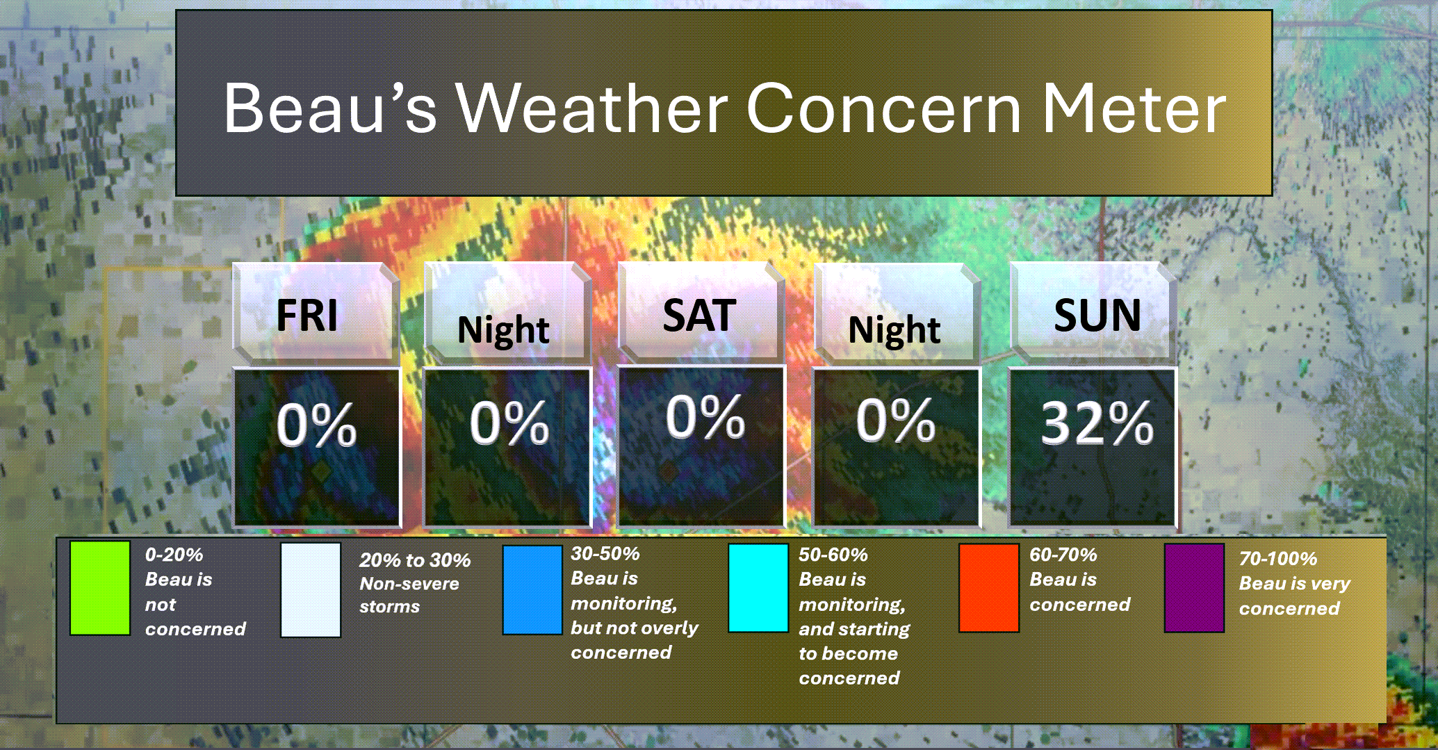
Here is the short-range thunderstorm concern meter.
I am monitoring Sunday afternoon and Sunday night. A few storms could be severe with high winds. There is a low risk of a short-lived tornado.
Confidence in severe weather is low. Most of the thunderstorms may occur behind the cold front. That would limit the threat. Monitor your Beau Dodson Weather App.
.
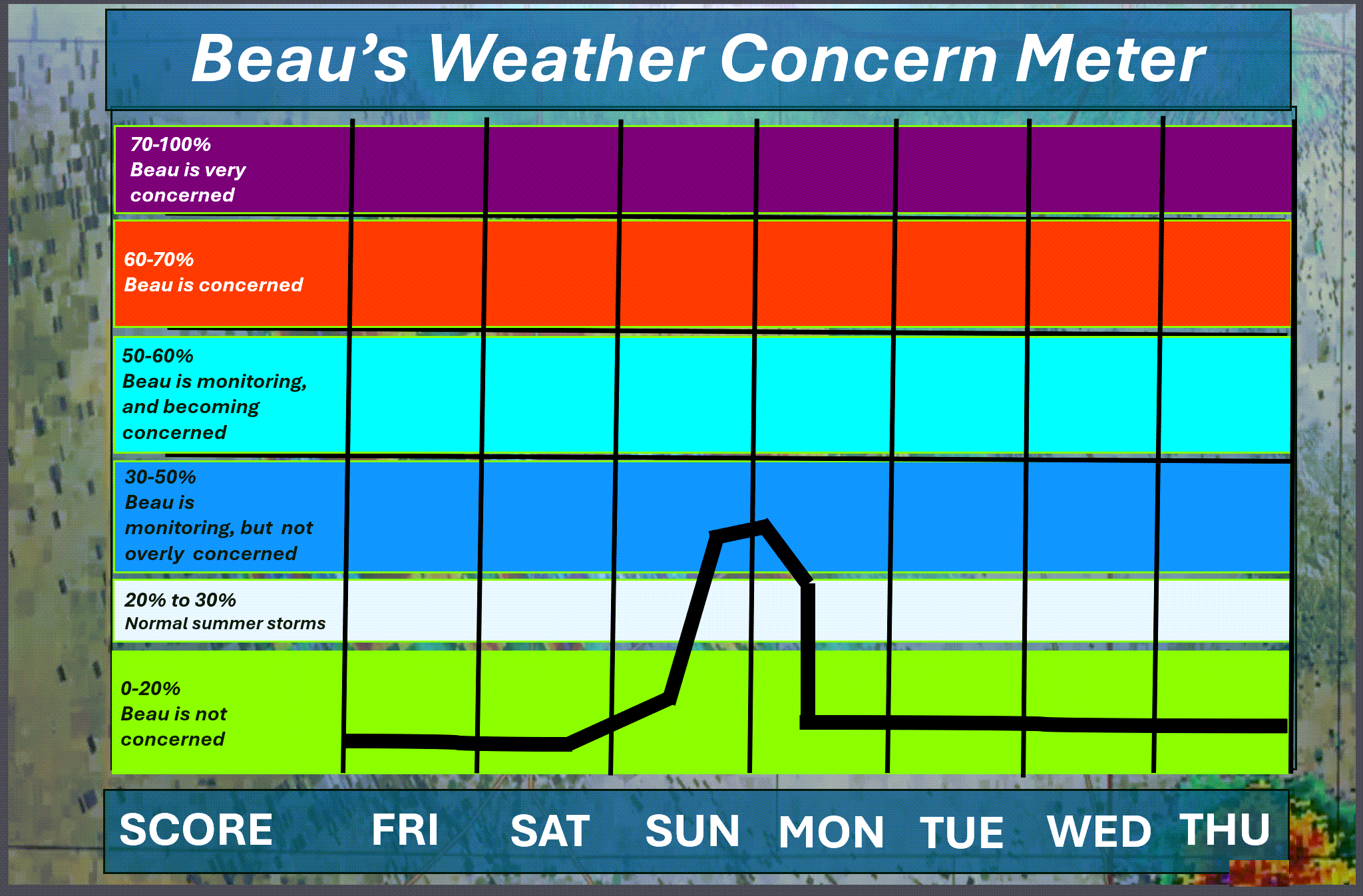
Here is the extended concern meter.
A strong cold front will bring showers and thunderstorms to the area on Sunday afternoon and Sunday night. A few of the storms could approach or reach severe levels.
The primary concern will be damaging wind. There is a low risk of a quick spin-up tornado, as well.
There remain questions about instability (CAPE). Limited CAPE would keep the severe weather risk low. Monitor updates.
.
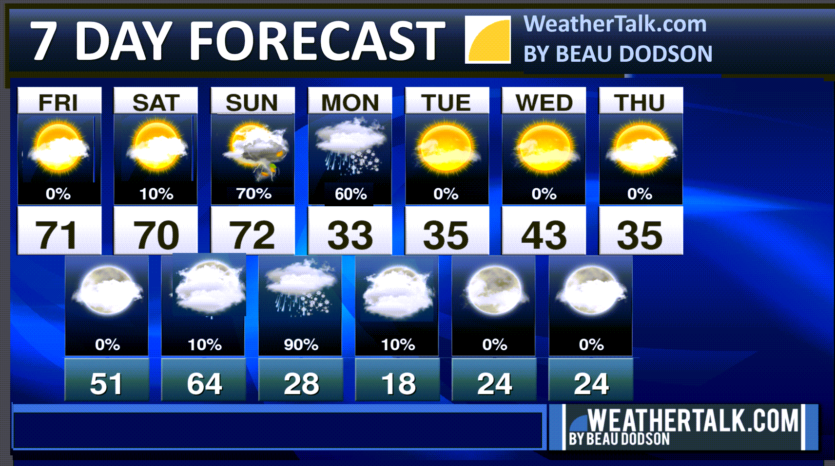
A quick forecast glance. Your 48-hour forecast Graphics


.
Here is your bus stop forecast
No school. Holidays.
.
This afternoon
No school. Holidays.
.


Forecast discussion
- Warm today through Sunday.
- Much colder by Monday and Tuesday.
- A strong cold front will bring showers to the region on Sunday and Sunday night. Ending on Monday morning.
- A few thunderstorms will be possible on Sunday night. I can’t rule out a severe thunderstorm, but confidence in severe weather remains low.
.
 .
.
.
What is the primary weather concern?
The primary weather concern will be widespread showers and thunderstorms on Sunday afternoon and Sunday night. Much colder air will arrive behind that cold front.
A few of the thunderstorms could be severe on Sunday afternoon and Sunday night. Confidence, however, remains low. Monitor your Beau Dodson Weather App.
The Storm Prediction Center/NOAA has placed us in a level one severe weather risk for Sunday afternoon into early Monday morning.
The dark green zone is the level one risk. That is the lowest risk that the SPC has. The scale ranges from one to five.
The light green zone is where lightning is possible, but severe storms are not anticipated.

.
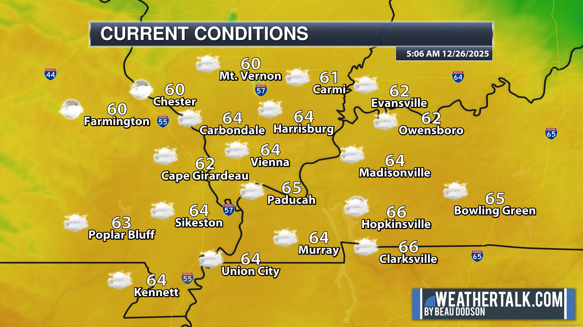
Here were the 6 AM temperatures. A mild start to your Friday.
.
Seven-day outlook graphic.
See the video or graphics below for more details specific to your county. This is a broad-brush overview of the entire region.
.
Today through Saturday night
I hope you had a nice Christmas and are enjoying the holiday weekend!
We had a nice time with family and friends.
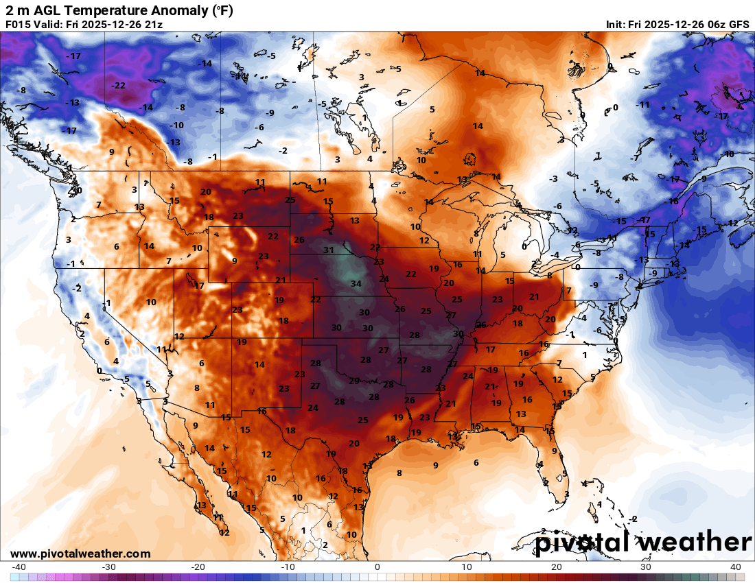
The big weather story through Saturday night will be the unseasonably warm temperatures.
Just look at these temperature anomalies. This graphic shows you how many degrees above average temperatures will be.
Some locations will be 40 degrees above seasonal averages!
Just look at how large an area those warm temperatures will cover.
Double-click the image to enlarge it.
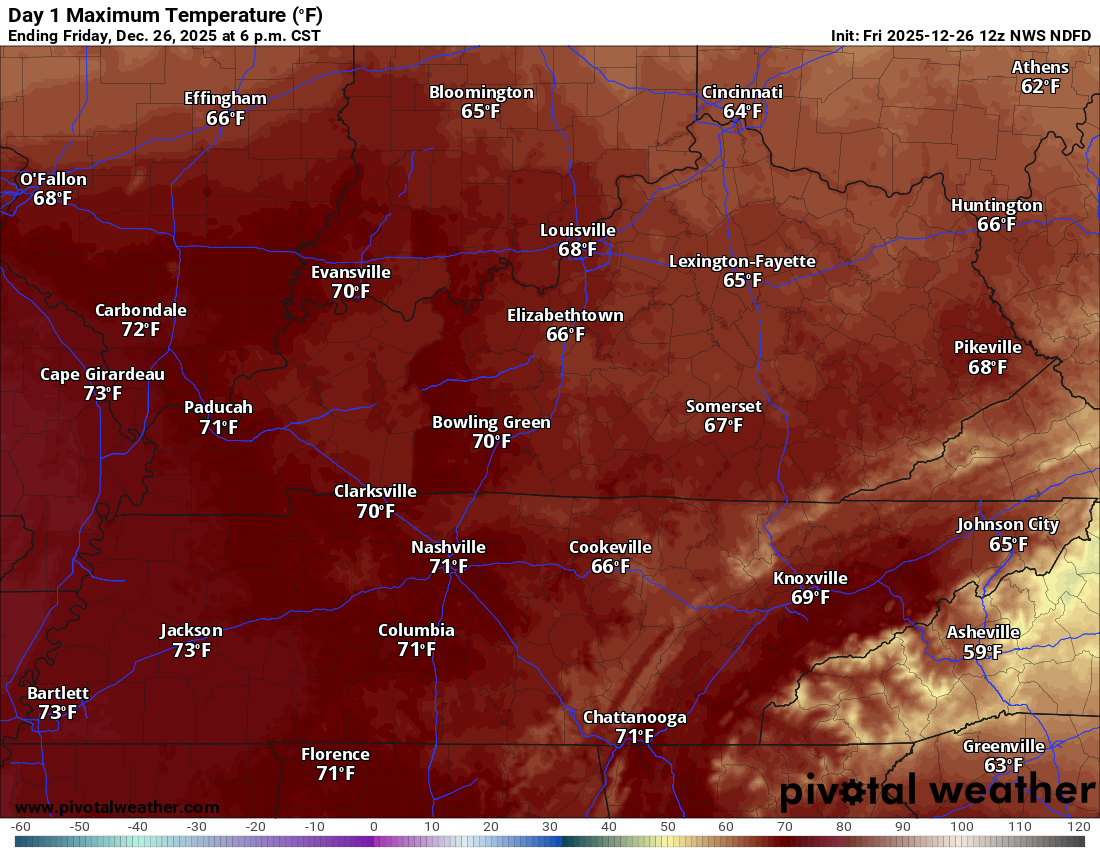
Near record or record highs are anticipated today through Sunday.
Record high low temperatures are likely, as well.
That equals highs in the upper 60s to middle 70s. That equals low temperatures in the fifties and sixties! Quite amazing for this time of the year.
What is more amazing is the longevity of these warm temperatures. Quite rare. We are lucky that we haven’t had severe weather, as well. Typically, highs like this would mean tornadoes! Let’s count our blessings.
We will have a mix of sun and clouds through Saturday night.
A small chance of patchy drizzle.
Today’s highs
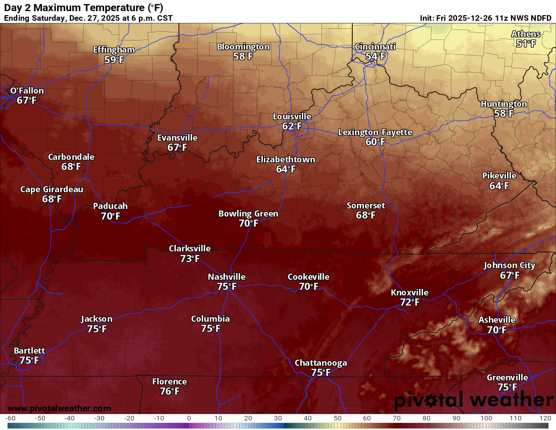
Saturday highs
.
Sunday through Tuesday
Sunday will deliver a mix of sun and clouds. A few scattered showers will be possible during the day. The bulk of the rain will hold off until late Sunday afternoon into Sunday night/Monday morning.
A strong cold front will arrive on Sunday night and Monday morning. This will bring showers and thunderstorms. It also means much colder temperatures for Monday/Tuesday.
This animation shows you how the temperatures will fall on Sunday night and Monday.
Double-click the animation to enlarge it.

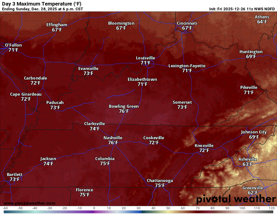
Sunday will be warm. Near record or record highs.
Sunday’s high temperatures
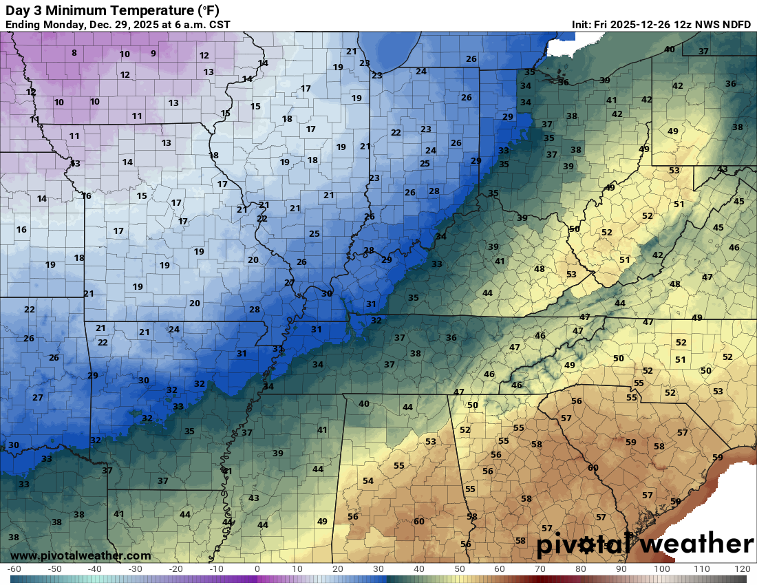
It will turn colder by Monday.
Monday morning low temperatures
We will need to monitor the speed of the front. Temperatures will be highly dependent on the front moving east of our region (colder behind the front).
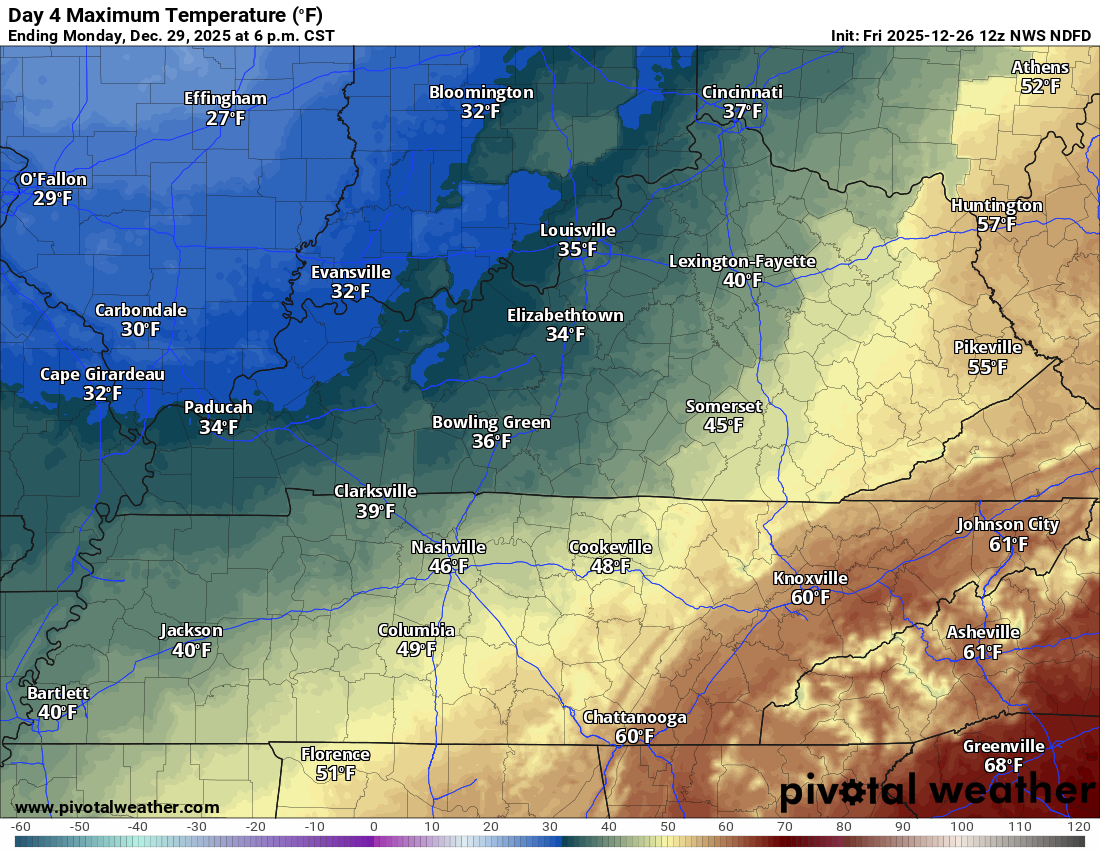
Monday’s high temperatures
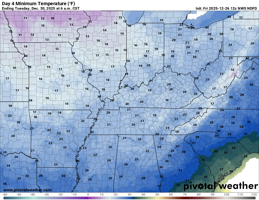
Tuesday morning low temperatures
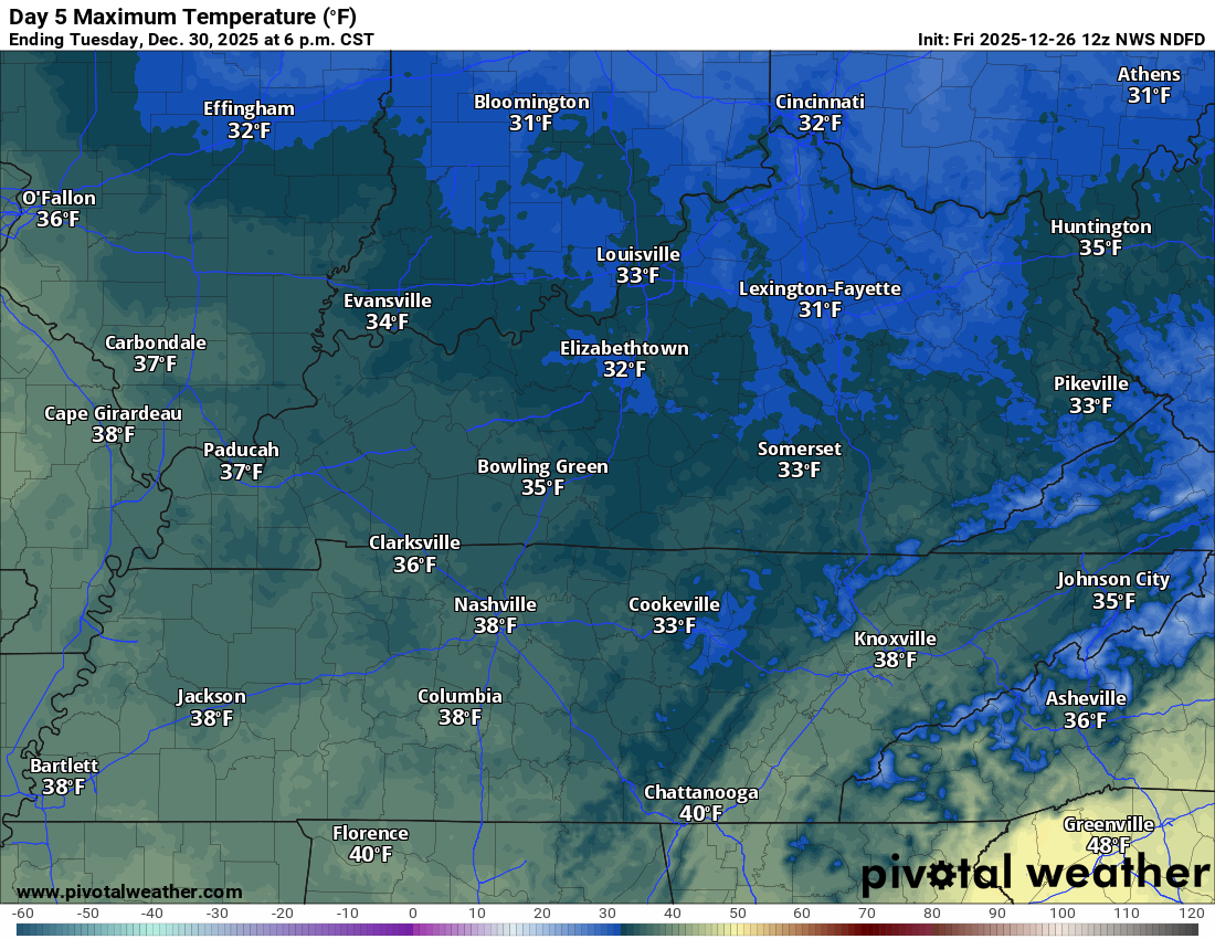
Tuesday’s high temperatures
Wednedsay morning low temperatures
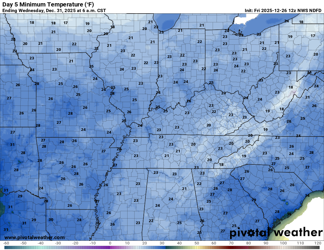
Wind chill values on Monday and Tuesday will dip into the single digits and teens. Brr.
The front will be accompanied by showers and perhaps some thunderstorms.
There are some limiting factors for the risk of severe weather.
- The front will have a limited amount of CAPE (energy that storms tap into).
- Much of the precipitation may occur behind the cold front. That would limit the risk of surface-based thunderstorms. That would limit the risk of severe weather.
There will be plenty of wind shear. Wind shear is the turning of air with height. Wind shear is an increase in wind speed with height. Basically, it equals spin in the atmosphere.
If thunderstorms can become surface-based, then there will be a risk of damaging wind gusts and a short-lived EF0/EF1 tornado.
See the SPC outlook above.
Monitor your Beau Dodson Weather app. I will send out messages.
The bulk of the rain will occur from late Sunday afternoon into Sunday night and early Monday morning. The front has slowed by about six to twelve hours.
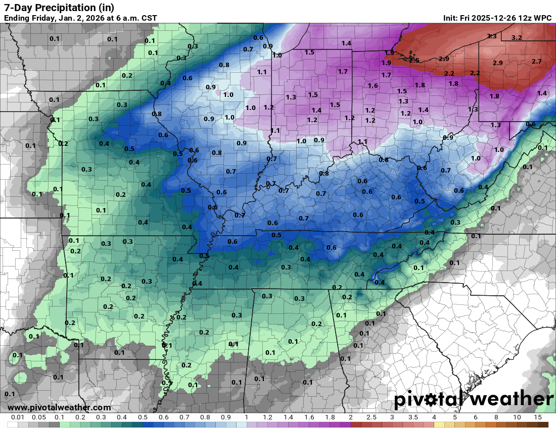
Let’s look at the rainfall totals. Most of this will fall on Sunday night. It may end as light snow. At this time, we do not expect much snow. Perhaps a dusting or so in spots. I will monitor trends.
At this time, we anticipate 0.40″ to 0.70″ of rain.
Double-click the image to enlarge it.
.

.
The timestamp (upper left) is in Zulu. 12z=6 am. 18z=12 pm. 00z=6 pm.
Double-click the animation to enlarge it.
Green is rain. Yellow is moderate rain. Blue is snow.
NAM model
.
.
The timestamp (upper left) is in Zulu. 12z=6 am. 18z=12 pm. 00z=6 pm.
Double-click the animation to enlarge it.
Green is rain. Yellow is moderate rain. Blue is snow.
GFS model
.
..
.
Click here if you would like to return to the top of the page.
.Average high temperatures for this time of the year are around 43 degrees.
Average low temperatures for this time of the year are around 26 degrees.
Average precipitation during this time period ranges from 1.00″ to 1.25″
Six to Ten Day Outlook.
Blue is below average. Red is above average. The no color zone represents equal chances.
Average highs for this time of the year are in the lower 60s. Average lows for this time of the year are in the lower 40s.

Green is above average precipitation. Yellow and brown favors below average precipitation. Average precipitation for this time of the year is around one inch per week.

.

Average low temperatures for this time of the year are around 25 degrees.
Average precipitation during this time period ranges from 1.00″ to 1.25″
.
Eight to Fourteen Day Outlook.
Blue is below average. Red is above average. The no color zone represents equal chances.

Green is above average precipitation. Yellow and brown favors below average precipitation. Average precipitation for this time of the year is around one inch per week.

.
.
.
We have a new service to complement your www.weathertalk.com subscription. This does NOTreplace www.weathertalk.com It is simply another tool for you to receive severe weather information.
.
https://weathercallservices.com/beau-dodson-weather


Want to receive the daily forecast/other products on your Beau Dodson Weather app?
Did you know you have four options in your www.weathertalk.com account
You will then receive these via your Beau Dodson Weather app.
Just log into your www.weathertalk.com account
Click the NOTIFICATION SETTINGS TAB
Then, turn them on (green) and off (red)
🌪️ Number 1 is the most important one. Severe alerts, tornado alerts, and so on.
Number 2 is the daily video, blog, livestream alerts, and severe weather Facebook threads on severe days or winter storm days.
Number 3 is the daily forecast. I send that out every day during the afternoon hours. It is the seven-day forecast, hazardous weather outlook, fire outlook, and more.
Number 4 is to receive the daily video, blog, and other content on NON-severe weather days (every day without severe threats in other words)
GREEN IS ON
RED IS OFF

I am going to start going live during bigger severe weather events.
Check it out here https://www.youtube.com/user/beaudodson
Click the subscribe button (it’s a free subscription button), and it will alert you when I go live. I will also send out alerts to the app when I go live for an event.

.

Radars and Lightning Data
Interactive-city-view radars. Clickable watches and warnings.
https://wtalk.co/B3XHASFZ
Old legacy radar site (some of you like it better)
https://weatherobservatory.com/weather-radar.htm
If the radar is not updating then try another one. If a radar does not appear to be refreshing then hit Ctrl F5. You may also try restarting your browser.
Backup radar site in case the above one is not working.
https://weathertalk.com/morani
Regional Radar
https://imagery.weathertalk.com/prx/RadarLoop.mp4
** NEW ** Zoom radar with chaser tracking abilities!
ZoomRadar
If the radar is not working, then email me: Email me at beaudodson@usawx.com
.
We do have some sponsors! Check them out.
Roof damage from recent storms? Link – Click here
INTEGRITY ROOFING AND EXTERIORS!
⛈️ Roof or gutter damage from recent storms? Today’s weather is sponsored by Integrity Roofing. Check out their website at this link https://www.ourintegritymatters.com/

![]()
![]()
![]()
Make sure you have three to five ways of receiving your severe weather information.
Weather Talk is one of those ways! Now, I have another product for you and your family.

.
Want to add more products to your Beau Dodson Weather App?
Receive daily videos, weather blog updates on normal weather days and severe weather and winter storm days, your county by county weather forecast, and more!
Here is how to do add those additional products to your app notification settings!
Here is a video on how to update your Beau Dodson Weather payment.
The app is for subscribers. Subscribe at www.weathertalk.com/welcome then go to your app store and search for WeatherTalk
Subscribers, PLEASE USE THE APP. ATT and Verizon are not reliable during severe weather. They are delaying text messages.
The app is under WeatherTalk in the app store.

Apple users click here

Android users click here
.
Radars and Lightning Data
Interactive-city-view radars. Clickable watches and warnings.
https://wtalk.co/B3XHASFZ
Old legacy radar site (some of you like it better)
https://weatherobservatory.com/weather-radar.htm
If the radar is not updating then try another one. If a radar does not appear to be refreshing then hit Ctrl F5. You may also try restarting your browser.
Backup radar site in case the above one is not working.
https://weathertalk.com/morani
Regional Radar
https://imagery.weathertalk.com/prx/RadarLoop.mp4
** NEW ** Zoom radar with chaser tracking abilities!
ZoomRadar
Lightning Data (zoom in and out of your local area)
https://wtalk.co/WJ3SN5UZ
Not working? Email me at beaudodson@usawx.com
National map of weather watches and warnings. Click here.
Storm Prediction Center. Click here.
Weather Prediction Center. Click here.
.

Live lightning data: Click here.
Real time lightning data (another one) https://map.blitzortung.org/#5.02/37.95/-86.99
Our new Zoom radar with storm chases
.
.

Interactive GOES R satellite. Track clouds. Click here.
GOES 16 slider tool. Click here.
College of DuPage satellites. Click here
.

Here are the latest local river stage forecast numbers Click Here.
Here are the latest lake stage forecast numbers for Kentucky Lake and Lake Barkley Click Here.
.
.
Find Beau on Facebook! Click the banner.


 .
.