

.
I have some question-and-answer threads over on the Facebook page. Link to those threads CLICK HERE
Or email me at beaudodsonweather@gmail.com
..

🌪️ Seven-Day Tornado Outlook ⛈️
December 23rd through December 29th
Current risk: Severe weather is not anticipated at this time. I will monitor this coming Saturday.
Current confidence level: Medium confidence.
Comments:
.

Seven-Day Hazardous Weather Outlook
1. Is lightning in the forecast? MONITOR. I am keeping an eye on Saturday PM into Sunday.
2. Are organized/widespread severe thunderstorms in the forecast? NOT AT THIS TIME. I am monitoring Saturday PM and Sunday. At this time, there is not a severe weather risk.
4. Will non-thunderstorm winds top 40 mph? NO.
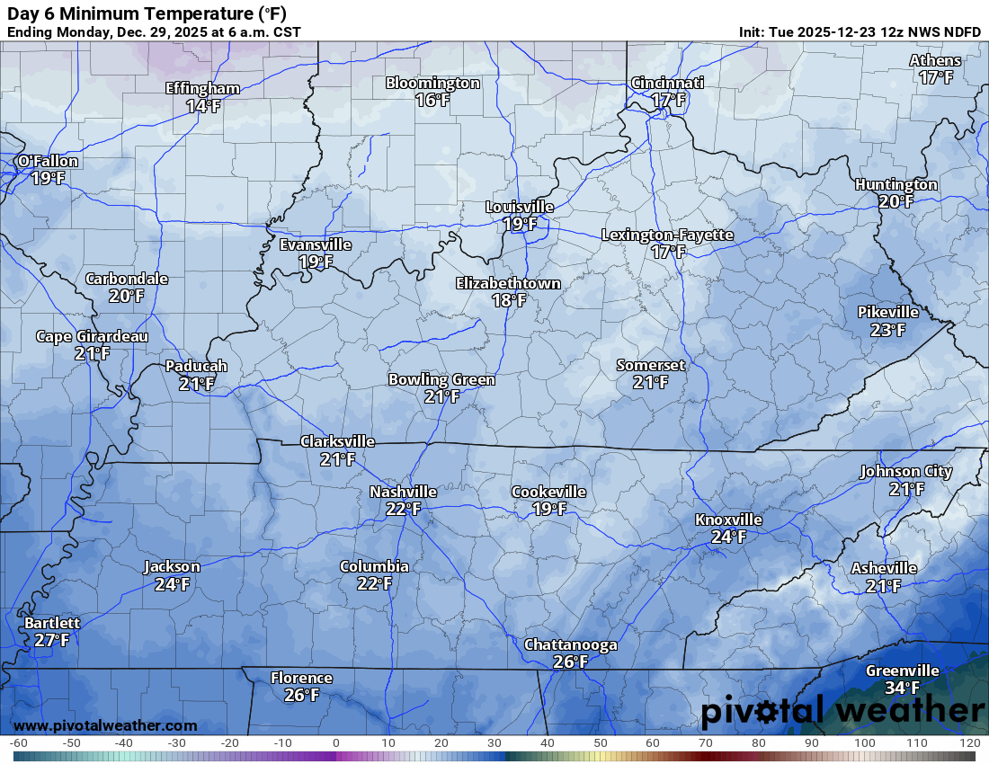
5. Will the temperature fall below 20 degrees? POSSIBLE. I am monitoring next Monday and Tuesday night.
6. Is the wind chill forecast to drop below ten degrees? NO.
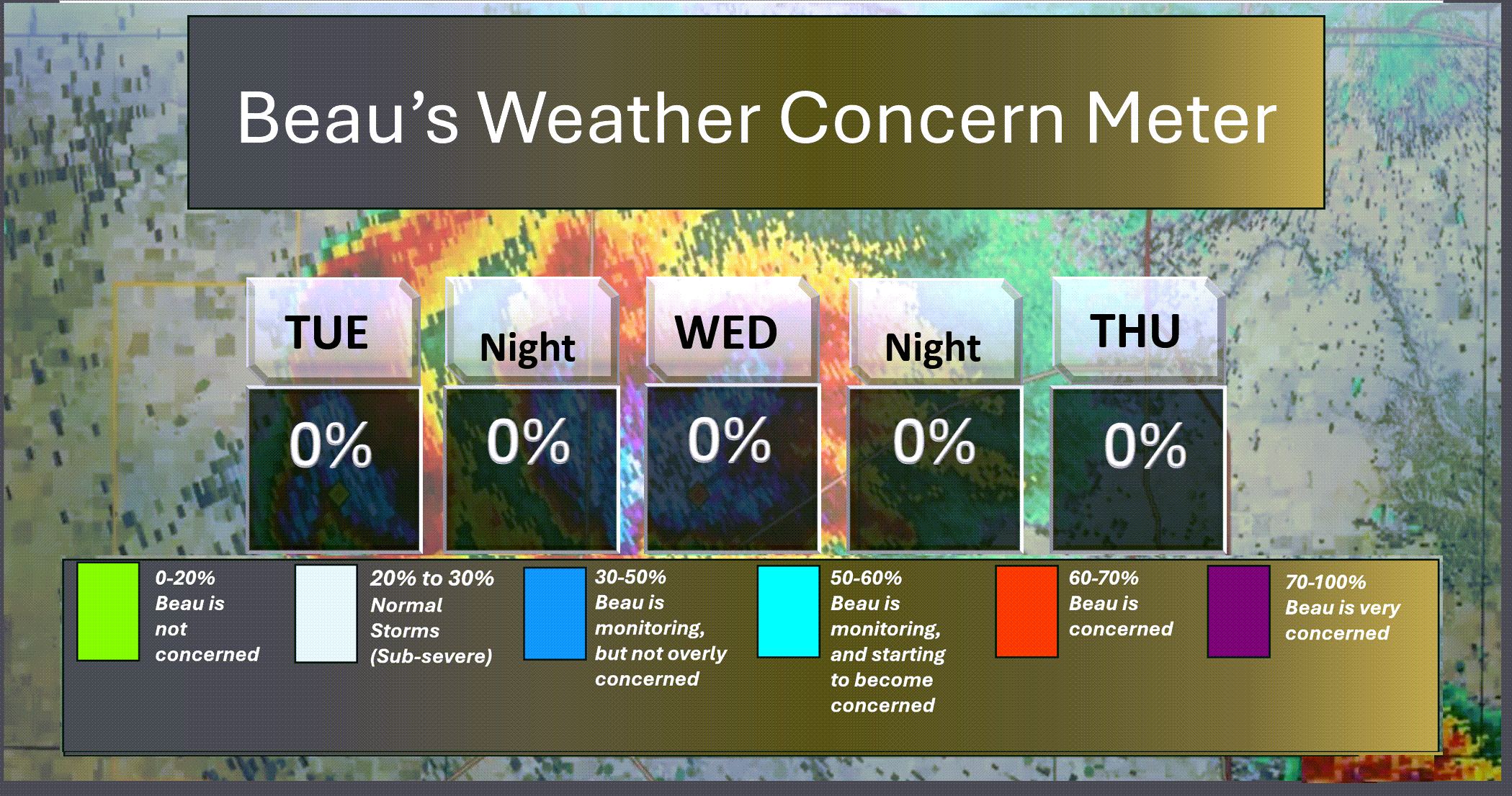
Here is the short-range thunderstorm concern meter.
.
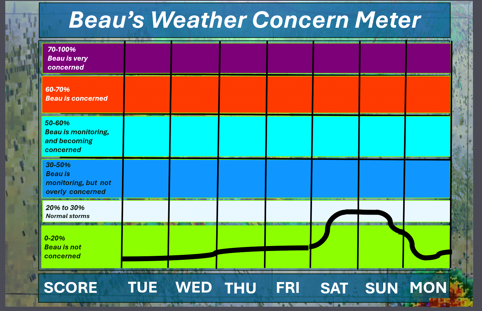
Here is the extended concern meter.
We could have lightning on Saturday PM into Sunday. I will be monitoring that system. For now, the severe weather appears minimal. Monitor updates.
.
A quick forecast glance. Your 48-hour forecast Graphics


.
Here is your bus stop forecast
No school. Holidays.
.
This afternoon
No school. Holidays.
.


Forecast discussion
- Mild temperatures ahead!
- Scattered on and off drizzle and shower chances.
- Rainfall totals will be light. Ranging from none to 0.15″. Not much.
- No significant storm systems through Friday.
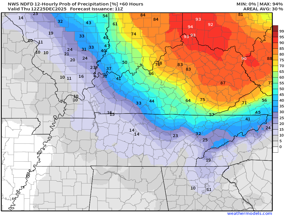
- I am watching a cold front on Saturday into Sunday. Showers may accompany that front. For now, the severe weather risk appears minimal. I am monitoring it.
.
 .
.
.
What is the primary weather concern?
We do have patchy fog in the region this morning. Use care.
No significant weather concerns through Friday. That is the good news. A warm holiday ahead of us.
.
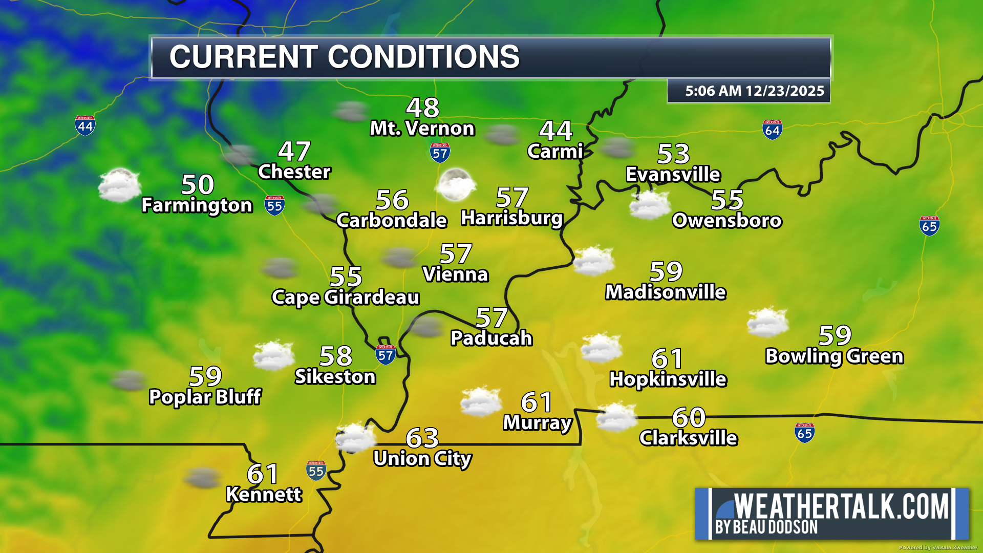
Here were the 6 AM temperatures. A mild start to your Tuesday.
We do have patchy fog in the region. Use care.
.
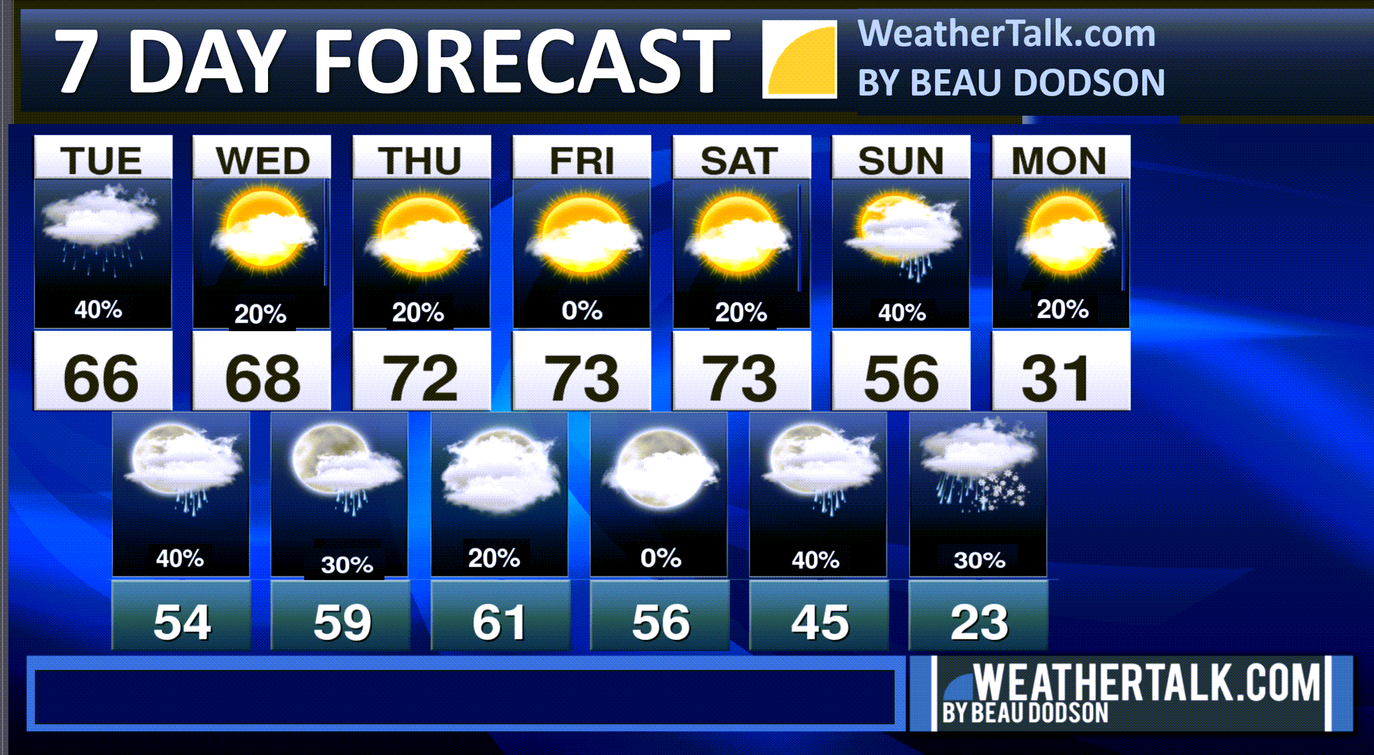
Seven-day outlook graphic.
See the video or graphics below for more details specific to your county. This is a broad-brush overview of the entire region.
.
Today through Christmas
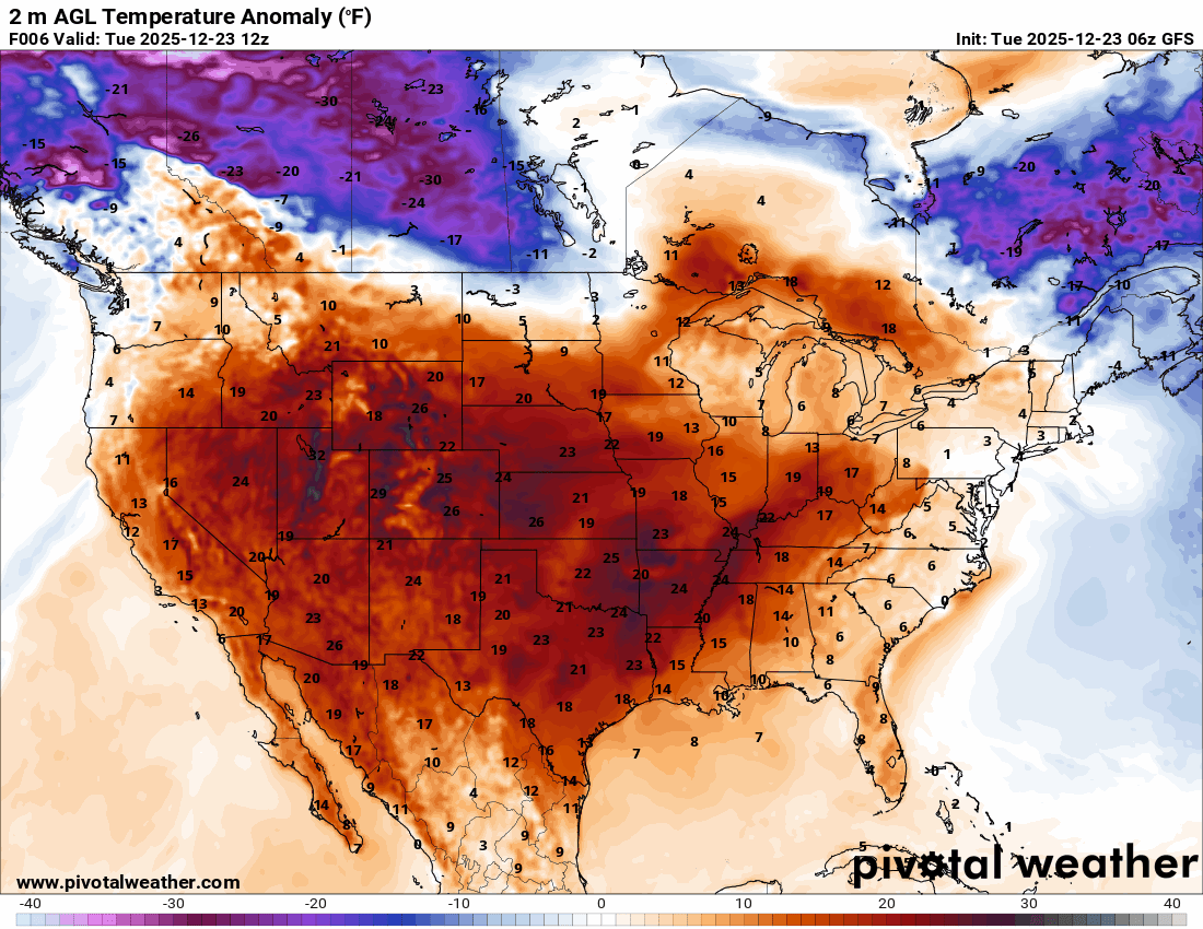
The big weather story continues to be the mild temperatures.
Look at this GFS model animation of the warm air. Those reds are well above average temperatures. At the end, you can see the colder air arriving on Sunday and Monday.
Some of these anomalies are 30+ degrees above seasonal averages. Impressive!
.
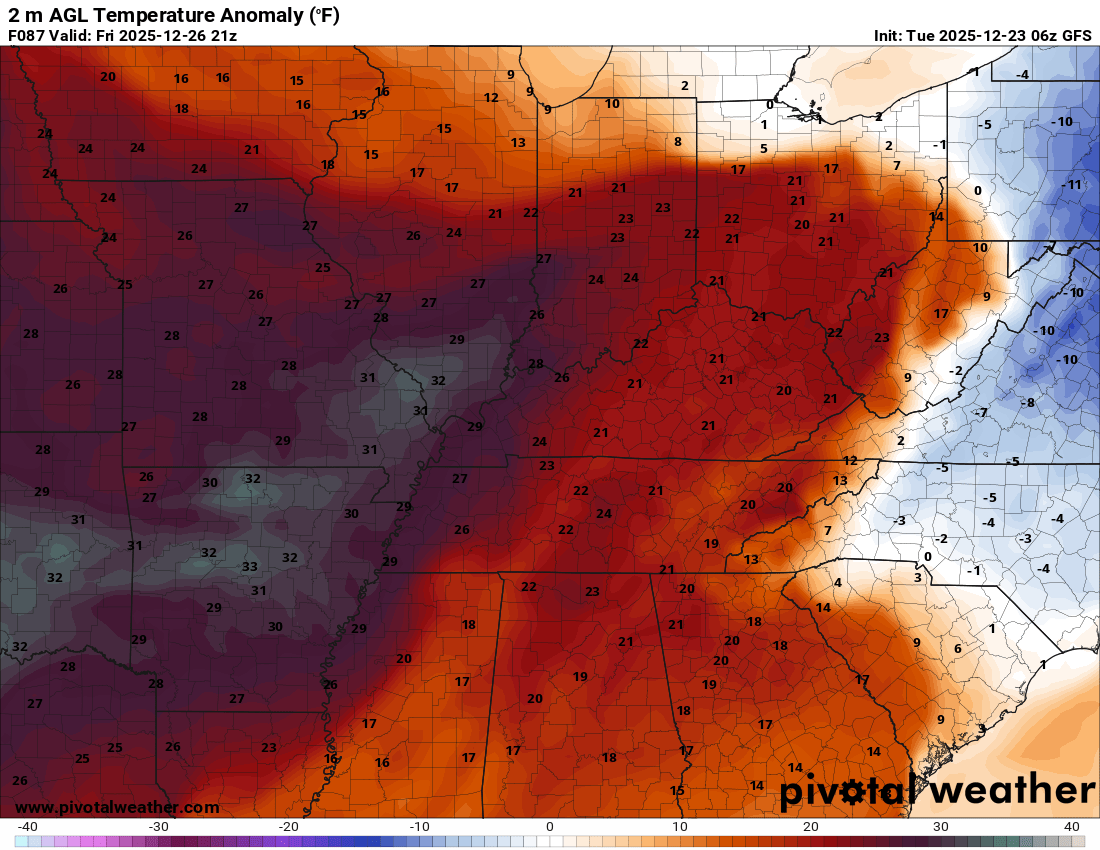
Zoomed in on Friday.
Temperatures in our region could be 30 degrees above seasonal averages!
.
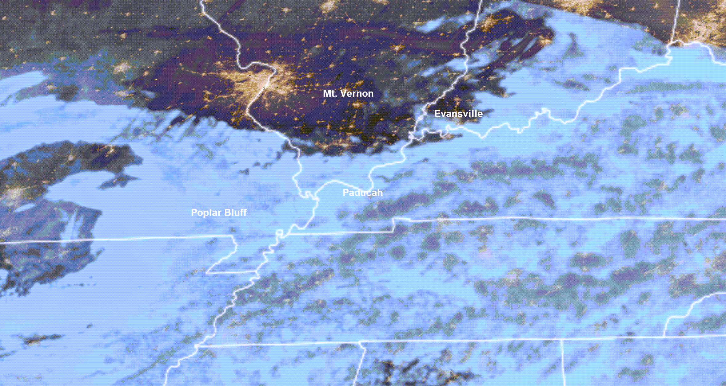
We are waking up to clouds over much of the area. Some clearing to the north.
You can see the clouds in this satellite image. This was taken at 6 AM.
Notice the clearing over our northern counties. That has allowed the temperatures to fall a bit more in those areas.
.
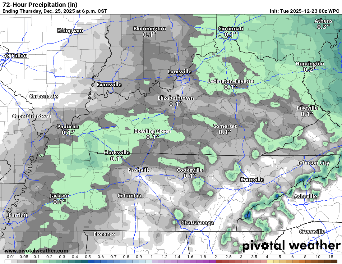
Radar shows drizzle and rain in the area. This will continue on and off into Thursday. Peak rain chances will be today. Then, lower precipitation chances over the coming days.
Let’s look at rain totals. As mentioned yesterday, the totals will be light.
As you can see, mainly in the 0.00″ to 0.15″ range.
Double-click on images to enlarge them.
.
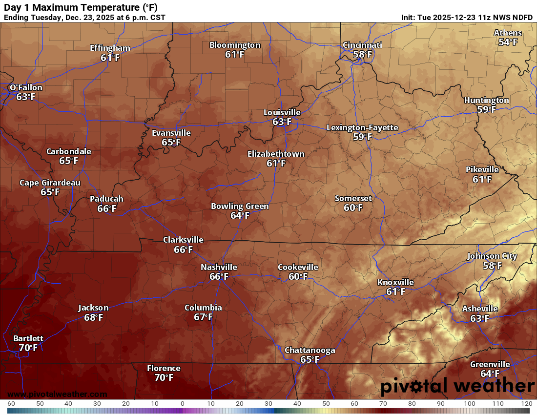
Let’s look at today’s high temperature map
.
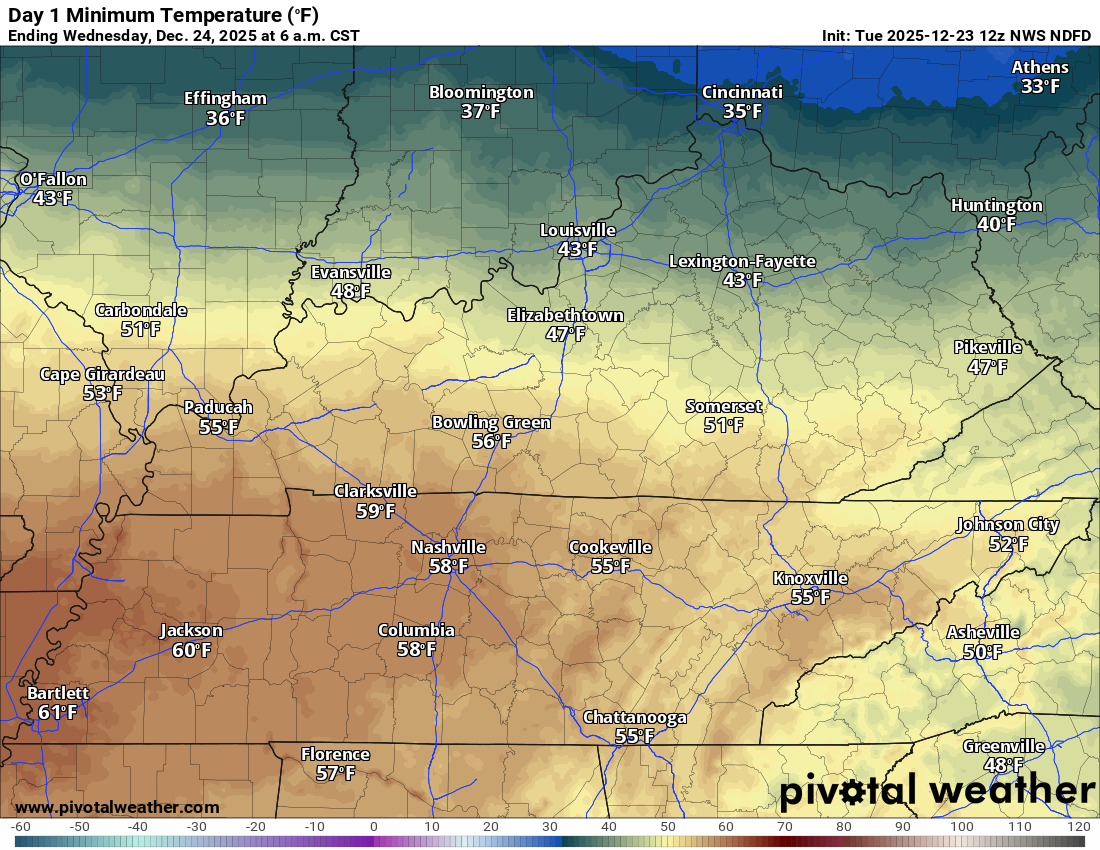
Wednesday morning lows
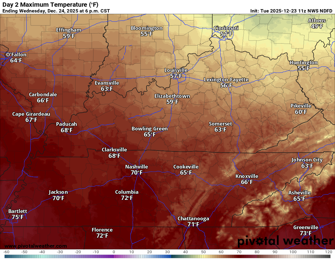
Tomorrow’s high temperature map
 .
.
.
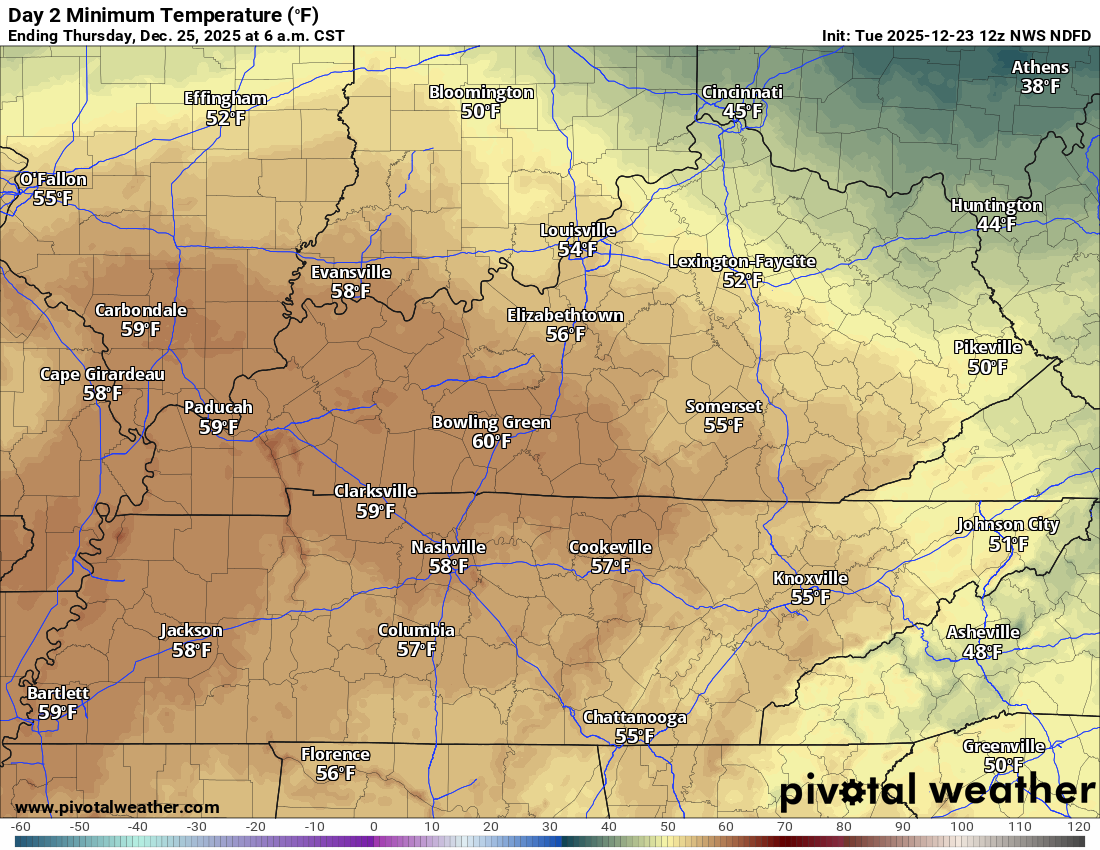
Thursday morning lows
.
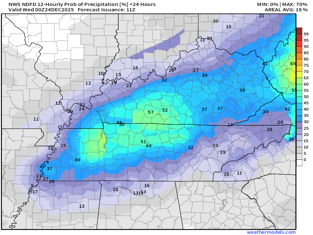
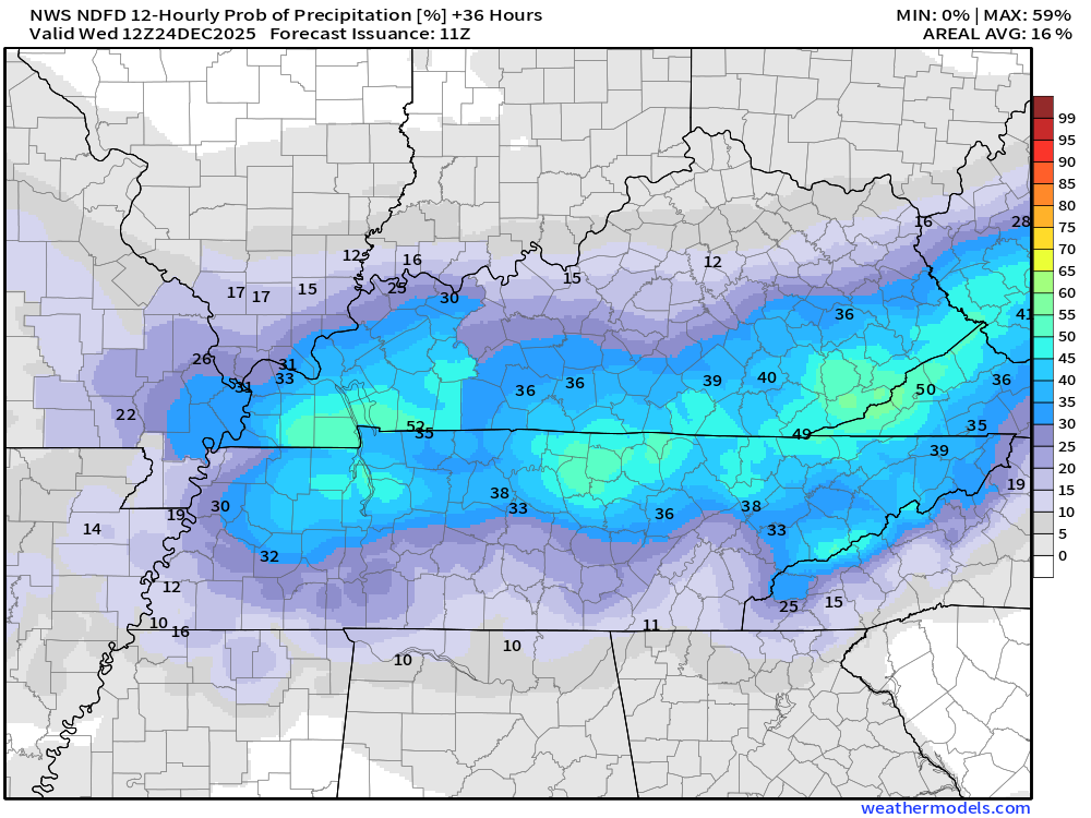
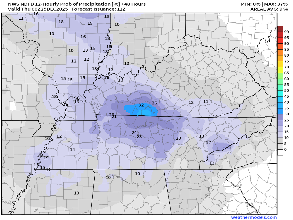
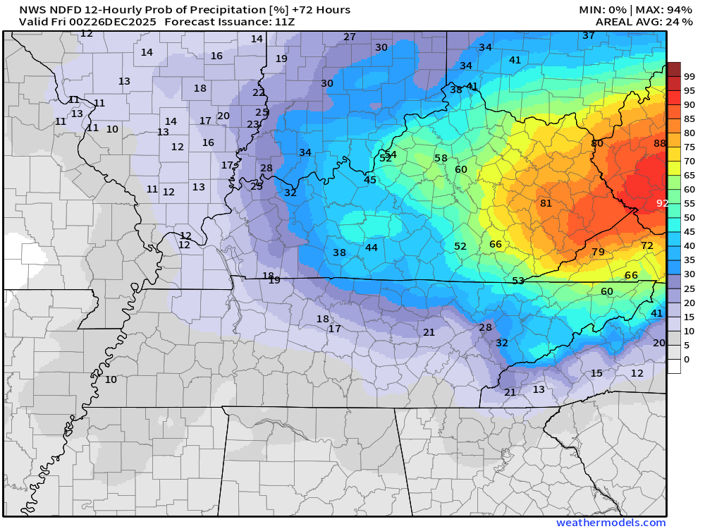
Let’s look at rain probabilities. What is the % chance of precipitation/rain?
Double-click on images to enlarge them.
As you can see, the chances are skewed towards our southern and eastern counties.
6 AM today to 6 PM tonight
6 PM tonight to 6 AM tomorrow
6 AM Wednesday to 6 PM Wednesday
6 PM Wednesday to 6 AM Thursday
.
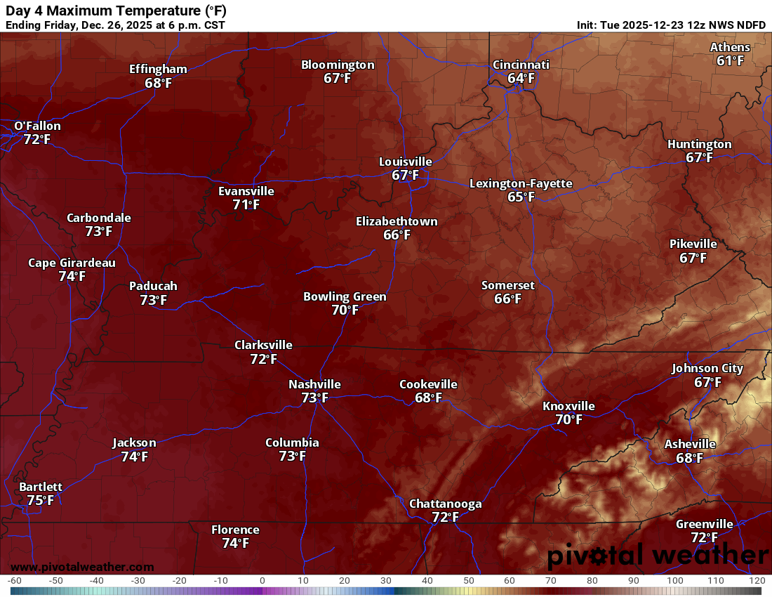
Friday through Monday
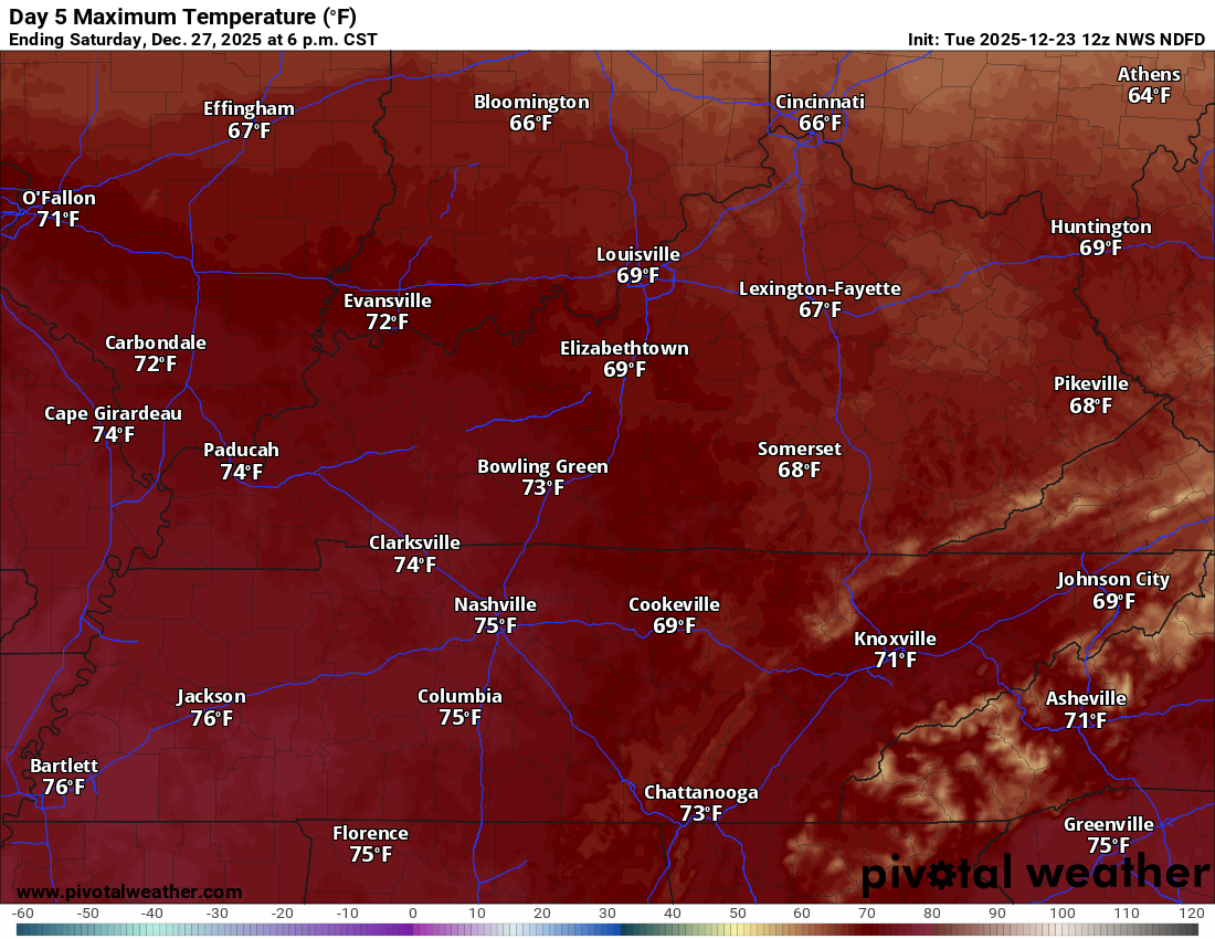
Friday will likely be one of the warmer days of the week.
A mix of sun and clouds. Highs in the seventies. We may break some records!
We will likely shatter overnight low temperatures. Meaning, this will be some of the warmest nights on record for this time of the year. Quite amazing.
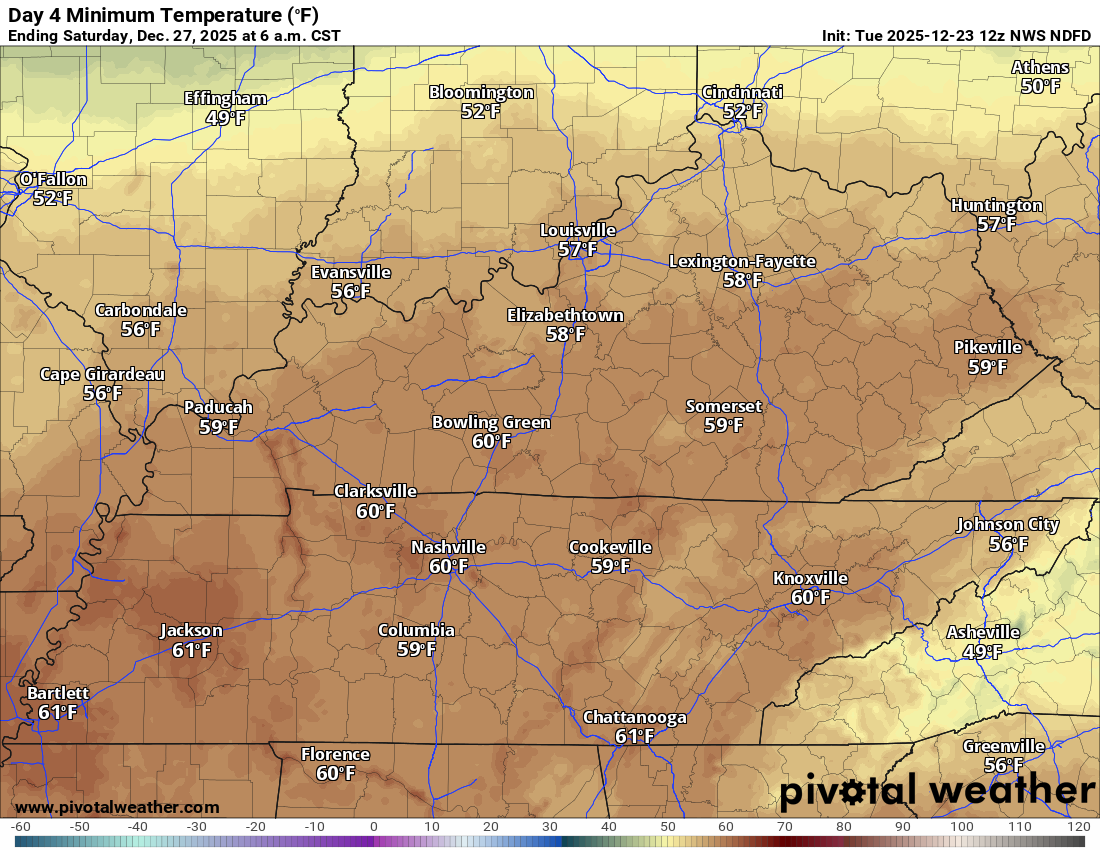
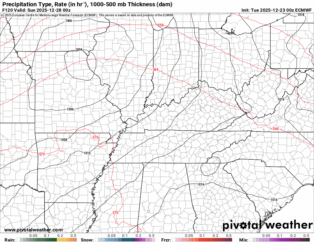
A strong cold front will push through the region on Saturday and Sunday. This will bring a chance of showers back to the area. Maybe a rumble of thunder.
At this time, we do not expect severe thunderstorms. I will monitor it, as well.
It is possible that some of my northern and western counties remain dry on Saturday and Sunday. A lot of the data shows higher rain chances over Kentucky and Tennessee. I will need to monitor and update that portion of the forecast.
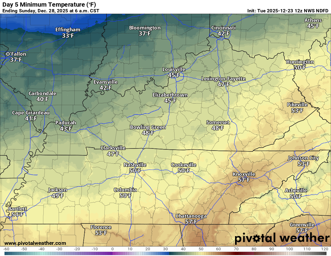
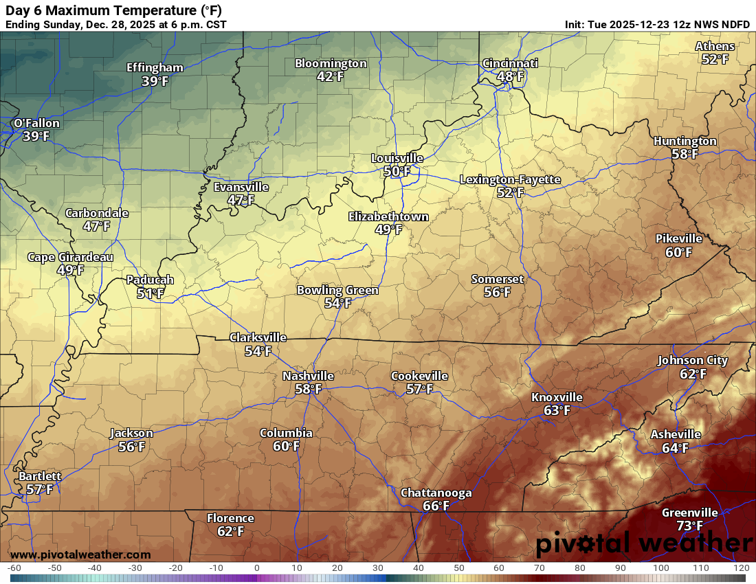
It will turn sharply colder on Sunday, Monday, and Tuesday. That cold air will arrive behind the cold front.
Gusty winds, at times.
Let’s look at those temperatures.
Friday morning lows
Friday’s high temperatures
.
Saturday morning lows
.
Saturday’s high temperatures
.
Sunday morning low temperatures
.
Sunday’s high temperatures
Monday morning low temperatures
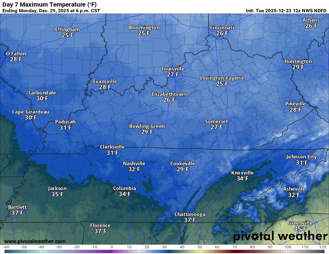
This is the EC model showing you the Saturday and Sunday cold front.
A lot of this precipitation is behind the cold front.
If that occurs, then it would limit the severe weather risk to nearly zero. I am closely monitoring it.
The time stamp is at the top of the image (on the left).
The timestamp (upper left) is in Zulu. 12z=6 am. 18z=12 pm. 00z=6 pm.
.
Have a nice day and a very Merry Christmas!
.

.
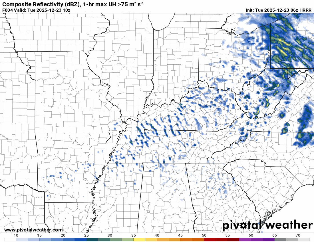
The timestamp (upper left) is in Zulu. 12z=6 am. 18z=12 pm. 00z=6 pm.
Double-click the animation to enlarge it.
Hrrr model
.
.
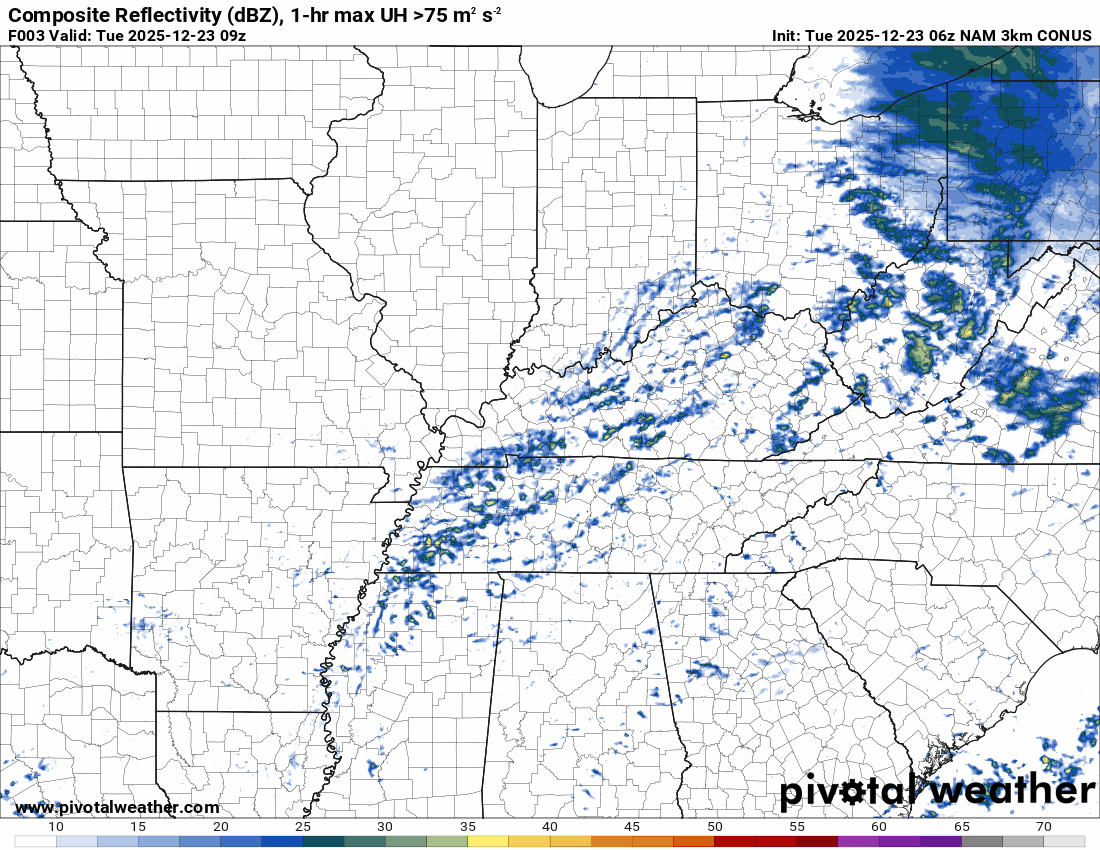
The timestamp (upper left) is in Zulu. 12z=6 am. 18z=12 pm. 00z=6 pm.
Double-click the animation to enlarge it.
NAM 3K model
.
..
.
Click here if you would like to return to the top of the page.
.Average high temperatures for this time of the year are around 43 degrees.
Average low temperatures for this time of the year are around 26 degrees.
Average precipitation during this time period ranges from 1.00″ to 1.25″
Six to Ten Day Outlook.
Blue is below average. Red is above average. The no color zone represents equal chances.
Average highs for this time of the year are in the lower 60s. Average lows for this time of the year are in the lower 40s.

Green is above average precipitation. Yellow and brown favors below average precipitation. Average precipitation for this time of the year is around one inch per week.

.

Average low temperatures for this time of the year are around 25 degrees.
Average precipitation during this time period ranges from 1.00″ to 1.25″
.
Eight to Fourteen Day Outlook.
Blue is below average. Red is above average. The no color zone represents equal chances.

Green is above average precipitation. Yellow and brown favors below average precipitation. Average precipitation for this time of the year is around one inch per week.

.
.
.
We have a new service to complement your www.weathertalk.com subscription. This does NOTreplace www.weathertalk.com It is simply another tool for you to receive severe weather information.
.
https://weathercallservices.com/beau-dodson-weather


Want to receive the daily forecast/other products on your Beau Dodson Weather app?
Did you know you have four options in your www.weathertalk.com account
You will then receive these via your Beau Dodson Weather app.
Just log into your www.weathertalk.com account
Click the NOTIFICATION SETTINGS TAB
Then, turn them on (green) and off (red)
🌪️ Number 1 is the most important one. Severe alerts, tornado alerts, and so on.
Number 2 is the daily video, blog, livestream alerts, and severe weather Facebook threads on severe days or winter storm days.
Number 3 is the daily forecast. I send that out every day during the afternoon hours. It is the seven-day forecast, hazardous weather outlook, fire outlook, and more.
Number 4 is to receive the daily video, blog, and other content on NON-severe weather days (every day without severe threats in other words)
GREEN IS ON
RED IS OFF

I am going to start going live during bigger severe weather events.
Check it out here https://www.youtube.com/user/beaudodson
Click the subscribe button (it’s a free subscription button), and it will alert you when I go live. I will also send out alerts to the app when I go live for an event.

.

Radars and Lightning Data
Interactive-city-view radars. Clickable watches and warnings.
https://wtalk.co/B3XHASFZ
Old legacy radar site (some of you like it better)
https://weatherobservatory.com/weather-radar.htm
If the radar is not updating then try another one. If a radar does not appear to be refreshing then hit Ctrl F5. You may also try restarting your browser.
Backup radar site in case the above one is not working.
https://weathertalk.com/morani
Regional Radar
https://imagery.weathertalk.com/prx/RadarLoop.mp4
** NEW ** Zoom radar with chaser tracking abilities!
ZoomRadar
If the radar is not working, then email me: Email me at beaudodson@usawx.com
.
We do have some sponsors! Check them out.
Roof damage from recent storms? Link – Click here
INTEGRITY ROOFING AND EXTERIORS!
⛈️ Roof or gutter damage from recent storms? Today’s weather is sponsored by Integrity Roofing. Check out their website at this link https://www.ourintegritymatters.com/

![]()
![]()
![]()
Make sure you have three to five ways of receiving your severe weather information.
Weather Talk is one of those ways! Now, I have another product for you and your family.

.
Want to add more products to your Beau Dodson Weather App?
Receive daily videos, weather blog updates on normal weather days and severe weather and winter storm days, your county by county weather forecast, and more!
Here is how to do add those additional products to your app notification settings!
Here is a video on how to update your Beau Dodson Weather payment.
The app is for subscribers. Subscribe at www.weathertalk.com/welcome then go to your app store and search for WeatherTalk
Subscribers, PLEASE USE THE APP. ATT and Verizon are not reliable during severe weather. They are delaying text messages.
The app is under WeatherTalk in the app store.

Apple users click here

Android users click here
.
Radars and Lightning Data
Interactive-city-view radars. Clickable watches and warnings.
https://wtalk.co/B3XHASFZ
Old legacy radar site (some of you like it better)
https://weatherobservatory.com/weather-radar.htm
If the radar is not updating then try another one. If a radar does not appear to be refreshing then hit Ctrl F5. You may also try restarting your browser.
Backup radar site in case the above one is not working.
https://weathertalk.com/morani
Regional Radar
https://imagery.weathertalk.com/prx/RadarLoop.mp4
** NEW ** Zoom radar with chaser tracking abilities!
ZoomRadar
Lightning Data (zoom in and out of your local area)
https://wtalk.co/WJ3SN5UZ
Not working? Email me at beaudodson@usawx.com
National map of weather watches and warnings. Click here.
Storm Prediction Center. Click here.
Weather Prediction Center. Click here.
.

Live lightning data: Click here.
Real time lightning data (another one) https://map.blitzortung.org/#5.02/37.95/-86.99
Our new Zoom radar with storm chases
.
.

Interactive GOES R satellite. Track clouds. Click here.
GOES 16 slider tool. Click here.
College of DuPage satellites. Click here
.

Here are the latest local river stage forecast numbers Click Here.
Here are the latest lake stage forecast numbers for Kentucky Lake and Lake Barkley Click Here.
.
.
Find Beau on Facebook! Click the banner.


 .
.