.
Your daily forecast into the coming weekend.
Wednesday Night Forecast Details:
Forecast: Clearing. Colder. Patchy fog possible.
Temperatures: MO ~ 35 to 40 IL ~ 30 to 35 KY ~ 32 to 36
What is the chance of precipitation? MO ~ 0% IL ~ 0% KY ~ 0%
Coverage of precipitation: None
Wind chill values: 25 to 35
Accumulating snow or ice: No
Winds: Northeast becoming east winds at 4 to 8 mph
What impacts are anticipated from the weather? Patchy fog possible
My confidence in the forecast verifying: High
Is severe weather expected? No
The NWS defines severe weather as 58 mph wind or great, 1″ hail or larger, and/or tornadoes
Should I cancel my outdoor plans: No
.
December 21, 2017
Thursday Forecast Details
Forecast: Partly cloudy. Warmer
Temperatures: MO ~ 56 to 62 IL ~ 54 to 58 KY ~ 55 to 60
What is the chance of precipitation? MO ~ 0% IL ~ 0% KY ~ 0%
Coverage of precipitation: None
Wind chill values: N/A
Accumulating snow or ice: No
Winds: South winds at 5 to 10 mph during the morning. Winds will become gusty on Thursday afternoon with gusts above 20 mph possible.
What impacts are anticipated from the weather? None
My confidence in the forecast verifying: High
Is severe weather expected? No
The NWS defines severe weather as 58 mph wind or great, 1″ hail or larger, and/or tornadoes
Should I cancel my outdoor plans? No
.
Thursday Night Forecast Details:
Forecast: Increasing clouds. A chance of late night showers.
Temperatures: MO ~ 45 to 50 IL ~ 45 to 50 KY ~ 45 to 50
What is the chance of precipitation? MO ~ 50% IL ~ 40% KY ~ 50%
Coverage of precipitation: Scattered to perhaps widespread late
Wind chill values: 40’s
Accumulating snow or ice: No
Winds: South and southwest winds at 5 to 10 mph with gusts to 15 mph
What impacts are anticipated from the weather? Perhaps wet roadways late
My confidence in the forecast verifying: High
Is severe weather expected? No
The NWS defines severe weather as 58 mph wind or great, 1″ hail or larger, and/or tornadoes
Should I cancel my outdoor plans: No
.
December 22, 2017
Friday Forecast Details
Forecast: Mostly cloudy. Showers increasing through the day.
Temperatures: MO ~ 52 to 58 IL ~ 52 to 56 KY ~ 54 to 58
What is the chance of precipitation? MO ~ 60% IL ~ 60% KY ~ 70%
Coverage of precipitation: Scattered to perhaps widespread. There remain some timing differences in guidance as to when the widespread rain arrives.
Wind chill values: N/A
Accumulating snow or ice: No
Winds: South and southwest at 8 to 16 mph and gusty
What impacts are anticipated from the weather? Wet roadways.
My confidence in the forecast verifying: High
Is severe weather expected? No
The NWS defines severe weather as 58 mph wind or great, 1″ hail or larger, and/or tornadoes
Should I cancel my outdoor plans? Have a plan B
.
Friday Night Forecast Details:
Forecast: Rain likely. Locally heavy rain possible, especially over west TN and west KY. Rain may mix with or change to a rain/snow mix or wet snow over southeast Missouri and southern Illinois. Perhaps western Kentucky, as well. Confidence remains low on the snow portion of the forecast. Turning colder late. Breezy.
Temperatures: MO ~ 28 to 34 IL ~ 30 to 34 KY ~ 30 to 35
What is the chance of precipitation? MO ~ 70% IL ~ 80% KY ~ 90%
Coverage of precipitation: Widespread
Wind chill values: 20 to 30
Accumulating snow or ice: Monitor updates
Winds: Becoming north at 7 to 14 mph with higher gusts possible.
What impacts are anticipated from the weather? Wet roadways. Small chance of flooding over some roads in Kentucky and Tennessee. I will monitor the snow potential.
My confidence in the forecast verifying: Medium
Is severe weather expected? Unlikely, but heavy rain is a possibility
The NWS defines severe weather as 58 mph wind or great, 1″ hail or larger, and/or tornadoes
Should I cancel my outdoor plans: Have a plan B
.
December 23, 2017
Saturday Forecast Details
Forecast: Mostly cloudy. Rain/snow mix or snow showers possible.
Temperatures: MO ~ 36 to 42 IL ~ 36 to 42 KY ~ 38 to 44
What is the chance of precipitation? MO ~ 60% IL ~ 60% KY ~ 60%
Coverage of precipitation: Widespread during the morning. Decreasing coverage through the afternoon.
Wind chill values: 30’s
Accumulating snow or ice: Small chance
Winds: Northwest at 10 to 20 mph
What impacts are anticipated from the weather? Wet roadways.
My confidence in the forecast verifying: Medium
Is severe weather expected? No
The NWS defines severe weather as 58 mph wind or great, 1″ hail or larger, and/or tornadoes
Should I cancel my outdoor plans? Have a plan B
.
Saturday Night Forecast Details:
Forecast: Mostly cloudy. Colder. Flurries possible.
Temperatures: MO ~ 24 to 28 IL ~ 22 to 26 KY ~ 24 to 28
What is the chance of precipitation? MO ~ 10% IL ~ 10% KY ~ 10%
Coverage of precipitation: Most of the precipitation should have ended. Small flurry chances.
Wind chill values: 20 to 25
Accumulating snow or ice: No
Winds: North and northwest at 5 to 10 mph
What impacts are anticipated from the weather? None
My confidence in the forecast verifying: High
Is severe weather expected? No
The NWS defines severe weather as 58 mph wind or great, 1″ hail or larger, and/or tornadoes
Should I cancel my outdoor plans: No
.
December 24, 2017
Sunday Forecast Details
Forecast: Increasing clouds. Snow showers possible during the afternoon. Greatest coverage of snow will likely be across the northern half of the region.
Temperatures: MO ~ 34 to 38 IL ~ 34 to 38 KY ~ 34 to 38
What is the chance of precipitation? MO ~ 30% IL ~ 50% KY ~ 40%
Coverage of precipitation: Scattered
Wind chill values: 20’s
Accumulating snow or ice: Monitor updates. I can’t rule out accumulation, but odds are against it.
Winds: North and northwest at 6 to 12 mph with gusts to 16 mph
What impacts are anticipated from the weather? Monitor updates
My confidence in the forecast verifying: Medium
Is severe weather expected? No
The NWS defines severe weather as 58 mph wind or great, 1″ hail or larger, and/or tornadoes
Should I cancel my outdoor plans? It will be cold
.
Sunday Night Forecast Details:
Forecast: Mostly cloudy. Colder. Snow showers possible.
Temperatures: MO ~ 16 to 22 IL ~ 16 to 22 KY ~ 20 to 25
What is the chance of precipitation? MO ~ 30% IL ~ 50% KY ~ 40%
Coverage of precipitation: Scattered, but monitor updates
Wind chill values: 10 to 20
Accumulating snow or ice: Monitor updates
Winds: West and northwest at 5 to 10 mph
What impacts are anticipated from the weather? Most likely none, but monitor the snow chances over southern Illinois and northwest Kentucky. Smaller chances elsewhere.
My confidence in the forecast verifying: Medium
Is severe weather expected? No
The NWS defines severe weather as 58 mph wind or great, 1″ hail or larger, and/or tornadoes
Should I cancel my outdoor plans: No
.
December 25, 2017
Monday Forecast Details
Forecast: Flurries possible early in the morning. Partly to mostly sunny. Cold.
Temperatures: MO ~ 35 to 40 IL ~ 32 to 36 KY ~ 34 to 38
What is the chance of precipitation? MO ~ 10% IL ~ 10% KY ~ 10%
Coverage of precipitation: None to isolated
Wind chill values: Upper teens to upper 20’s
Accumulating snow or ice: No
Winds: West and northwest at 6 to 12 mph
What impacts are anticipated from the weather? Most likely none
My confidence in the forecast verifying: High
Is severe weather expected? No
The NWS defines severe weather as 58 mph wind or great, 1″ hail or larger, and/or tornadoes
Should I cancel my outdoor plans? It will be cold
.
Monday Night Forecast Details:
Forecast: Partly cloudy and bitterly cold.
Temperatures: MO ~ 15 to 20 IL ~ 15 to 20 KY ~ 18 to 24
What is the chance of precipitation? MO ~ 0% IL ~ 0% KY ~ 0%
Coverage of precipitation: None anticipated
Wind chill values: 8 to 15
Accumulating snow or ice: No
Winds: West and northwest at 5 to 10 mph
What impacts are anticipated from the weather? Bitterly cold.
My confidence in the forecast verifying: High
Is severe weather expected? No
The NWS defines severe weather as 58 mph wind or great, 1″ hail or larger, and/or tornadoes
Should I cancel my outdoor plans: It will be quite cold
.
December 26, 2017
Tuesday Forecast Details
Forecast: Mostly sunny. A few passing clouds. Cold.
Temperatures: MO ~ 35 to 40 IL ~ 32 to 36 KY ~ 34 to 38
What is the chance of precipitation? MO ~ 0% IL ~ 0% KY ~ 0%
Coverage of precipitation: None
Wind chill values: 20’s and 30’s
Accumulating snow or ice: No
Winds: Variable at 5 to 10 mph
What impacts are anticipated from the weather? None
My confidence in the forecast verifying: High
Is severe weather expected? No
The NWS defines severe weather as 58 mph wind or great, 1″ hail or larger, and/or tornadoes
Should I cancel my outdoor plans? It will be cold
.
Tuesday Night Forecast Details:
Forecast: Partly cloudy and cold.
Temperatures: MO ~ 18 to 22 IL ~ 16 to 20 KY ~ 20 to 24
What is the chance of precipitation? MO ~ 0% IL ~ 0% KY ~ 0%
Coverage of precipitation: None
Wind chill values: 8 to 15
Accumulating snow or ice: No
Winds: Variable 5 to 10 mph
What impacts are anticipated from the weather? Bitterly cold.
My confidence in the forecast verifying: High
Is severe weather expected? No
The NWS defines severe weather as 58 mph wind or great, 1″ hail or larger, and/or tornadoes
Should I cancel my outdoor plans: It will be quite cold
.
.

.
Wednesday night through Thursday: High confidence. The risk for freezing rain, sleet, and snow is near zero.
Friday through Tuesday: Low confidence. Wintry precipitation can’t be ruled out Friday night and Saturday morning. Monitor updates.
Snow showers are possible Sunday and Monday, as well. The track of that system may be further north. This will need to be monitored. I can’t rule out light accumulations. The most likely area would be northern parts of southeast MO and northern parts of southern IL. Low confidence.
.

.
The National Weather Service definition of a severe thunderstorm is one that produces quarter size hail or larger, 58 mph winds or greater, and/or a tornado.
Wednesday night through Thursday: High confidence. Severe weather is unlikely.
Friday and Friday night: Low confidence. A stronger system will develop across the Central United States on Friday into Friday night. Showers and thunderstorms will be possible along an incoming cold front. I can’t rule out strong thunderstorms, but this is highly dependent on storm track. Monitor updates.
.

.
December 18th and 19th, 2017
Forecast
Interactive Weather Radar Page. Choose the city nearest your location: Click this link
Thursday
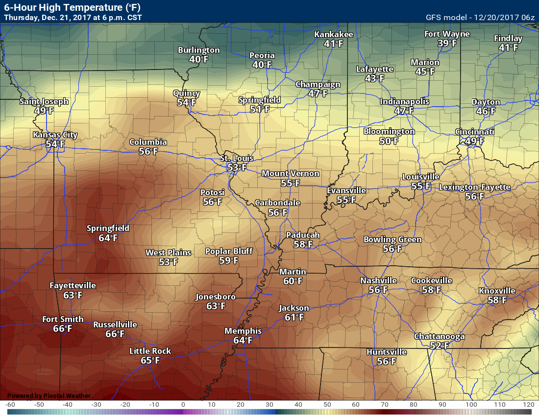
Thursday should remain dry. Perhaps some clouds. Temperatures are forecast to rise into the middle to upper 50’s over most of the area. Extreme northern portions of southern Illinois may remain in the lower to middle 50’s.
Some 60’s are possible Thursday. If we can maximize the sunshine those odds will increase.
GFS Thursday high temperatures.
.
.
Friday
A long shot chance of accumulating snow:
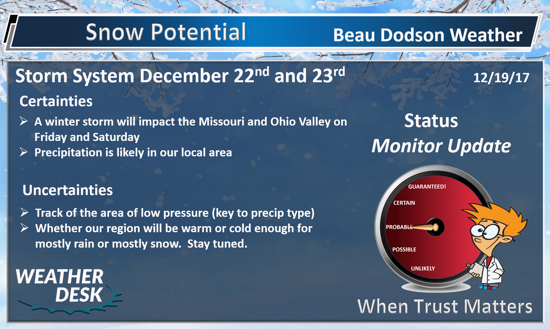
A forecast headache is developing Friday into Saturday. I keep telling everyone that I don’t think we will have a handle on the system until Wednesday night or Thursday. That is proving to be true.
At one point the guidance was taking the low pressure center into the Kansas City area. It was then tracking towards Chicago.
That would have meant thunderstorms (some strong) in our local area.
Over the last 24 hours, all of the guidance has trended further south and east. As a matter of fact, now the question is just how far south and east does the low track.
If the low tracks to our south or southeast then we will end up on the cold side of the system.
There remains questions on how fast the cold air arrives behind the area of low pressure, as well. If the cold isn’t fast enough then this will be an all rain event.
I suspect the northern and western edge of the precipitation shield will change to snow. Just a question of where.
The further southeast the low tracks, the greater the chance of rain changing to snow in our local area. I can’t rule out accumulation. Confidence on the snow accumulating remains low. We would have to have high snow rates in order for it to stick. The ground is quite warm and it will also be wet.
The confidence on the eventual track is low. I am hoping that confidence will increase today into tonight.
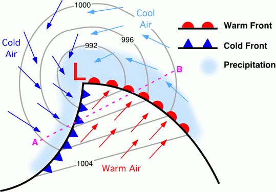
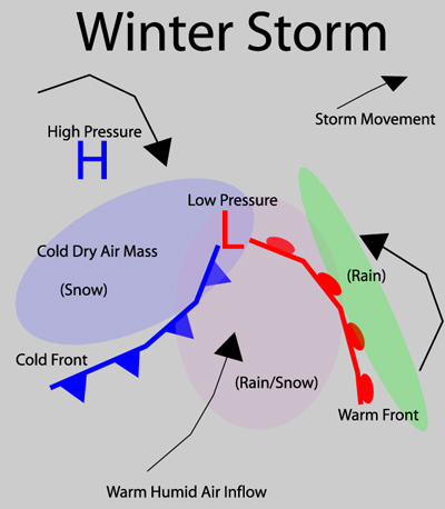
Here is a diagram of a typical storm system. The area of low pressure would be where the blue and red meet. The blue represents the cold front. The red represents the warm front. The L is the center of the area of low pressure. The arrows represent wind direction. Southerly winds ahead of the cold front. West and northwest winds behind the cold front.
Areas south and east of the low are warm. Areas north and west of the low are cold. The track and intensity of the surface low pressure is key to our eventual forecast.
.
.
The reason the forecast is so tricky is that I do not know the eventual track of the area of low pressure. At least not yet.
Monitor updated forecasts.
The main time-frame for precipitation will likely be late Friday night into Saturday morning. Guidance is not in agreement on the timing, either.
Some showers are possible as early as late Thursday night into Friday. The showers would most likely be scattered and light.
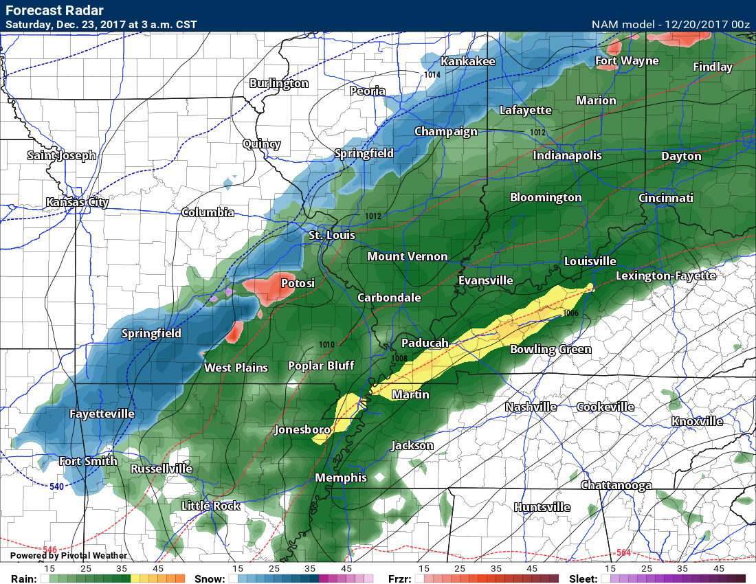
Models are all over the place. Let me show you a few.
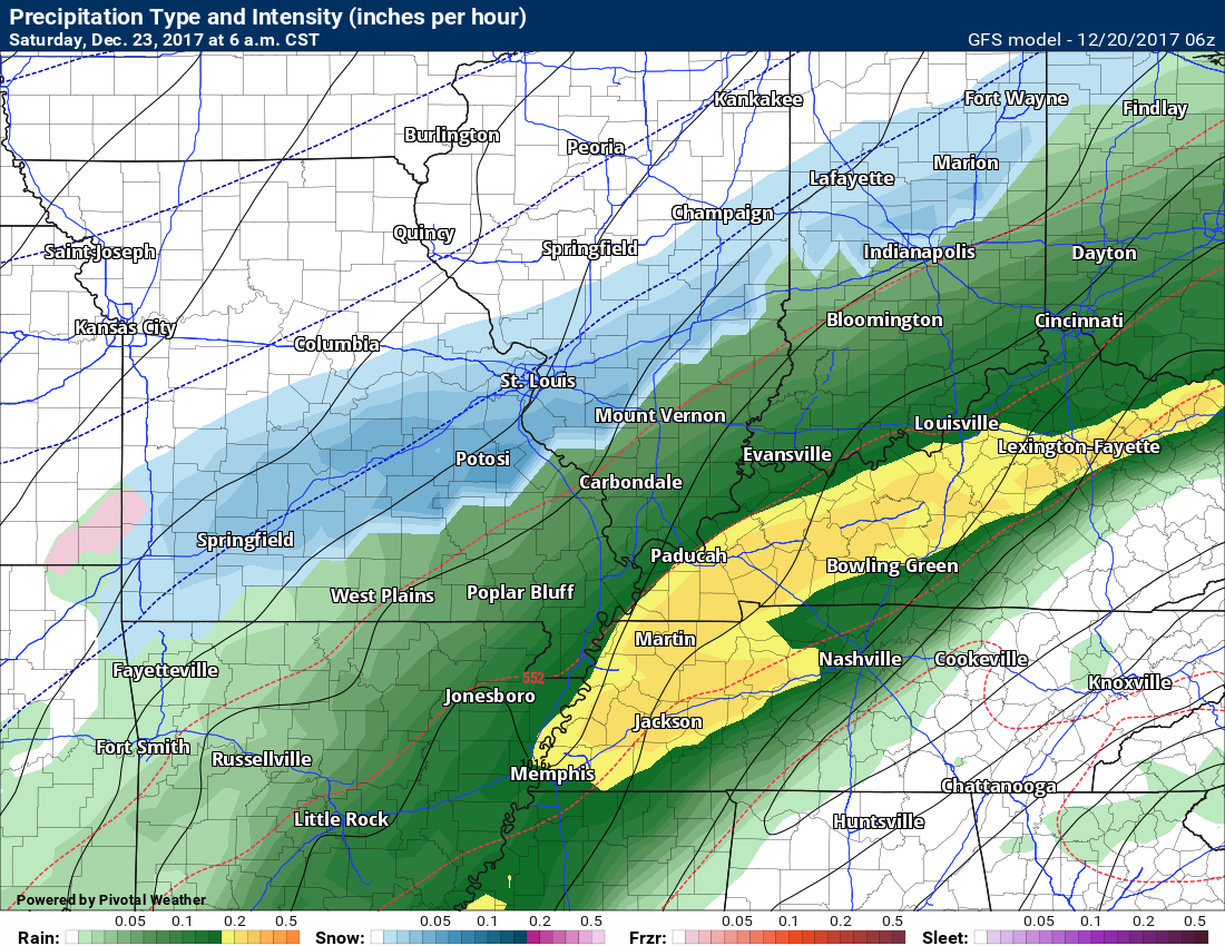
These maps show you precipitation. Green is rain. Yellow is heavy rain. Blue is snow. Dark blue is heavy snow.
This first map is the NAM model guidance
Saturday at 3 AM it has snow and rain in our region. Again, the track of the low is key. The strength of the low is also important.
Pink would be sleet on this particular graphic.
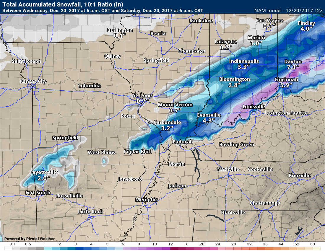
This is what the NAM shows for snow totals
Take the snow accumulation maps with a grain of salt. I am just showing you what the model is showing. Models don’t forecast. They simply show you what their algorithms tell them to show you. They are dumb, in other words. No human interaction. It is up to the meteorologist to interpret them.
.
.
This next map is the GFS model guidance
.
.
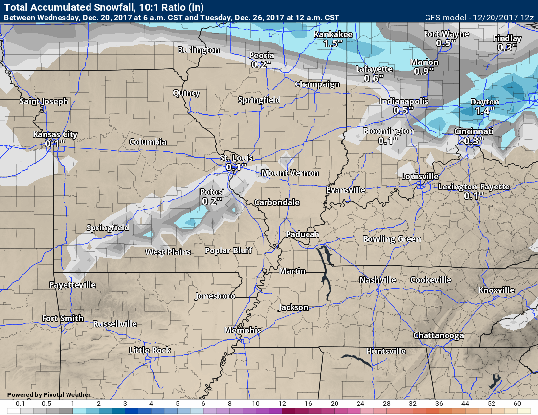
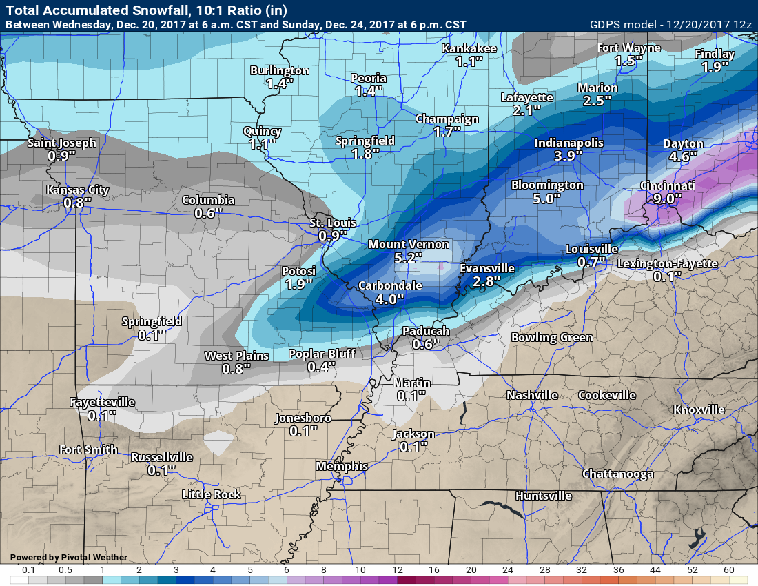
This is what the GFS show for snow totals
Take the snow accumulation maps with a grain of salt. I am just showing you what the model is showing. Models don’t forecast. They simply show you what their algorithms tell them to show you. They are dumb, in other words. No human interaction. It is up to the meteorologist to interpret them.
.
.
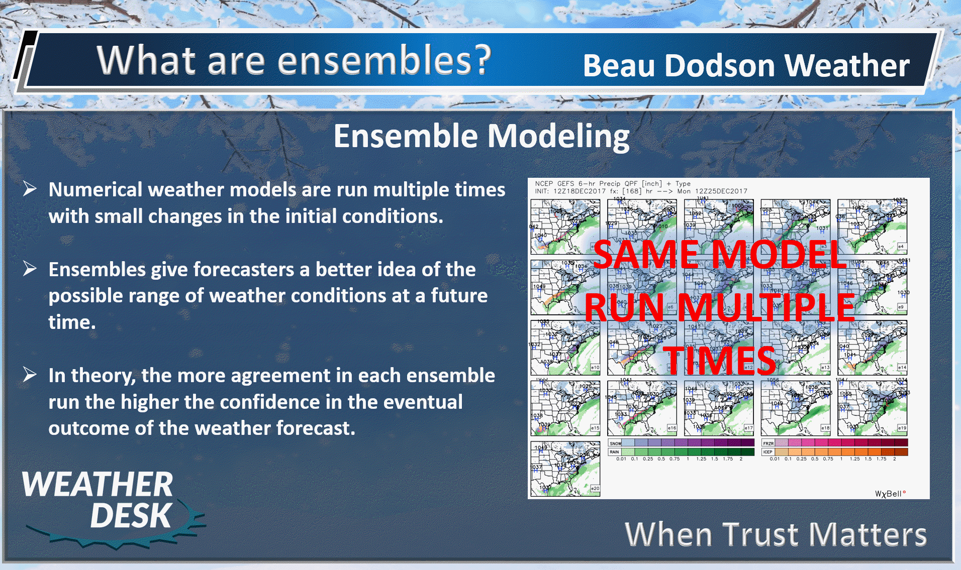
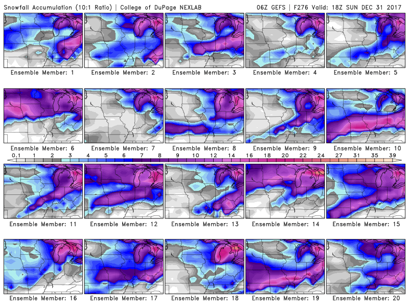
GFS ensembles are showing a strong signal for at least some snow in or near our region Friday/Saturday.
What are ensembles?
.
.
Here are the GFS snow ensembles
Click to enlarge the images on this page. The colors represent snow totals. Notice how many of them show a band of snow in our area. Each frame is one run of the GFS ensemble package.
Take the snow accumulation maps with a grain of salt. I am just showing you what the model is showing. Models don’t forecast. They simply show you what their algorithms tell them to show you. They are dumb, in other words. No human interaction. It is up to the meteorologist to interpret them.
.
.
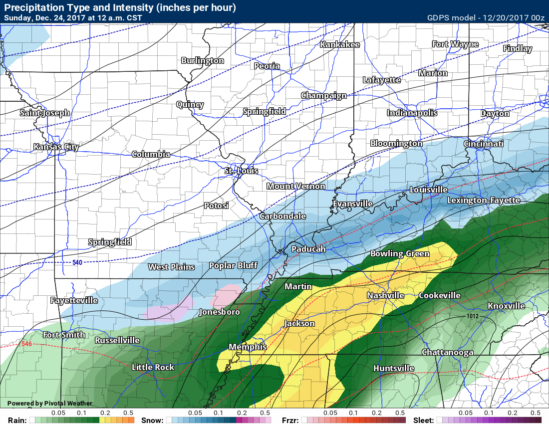
This next map is the Canadian model guidance
.
.
This is what the Canadian shows for snow totals
.
.
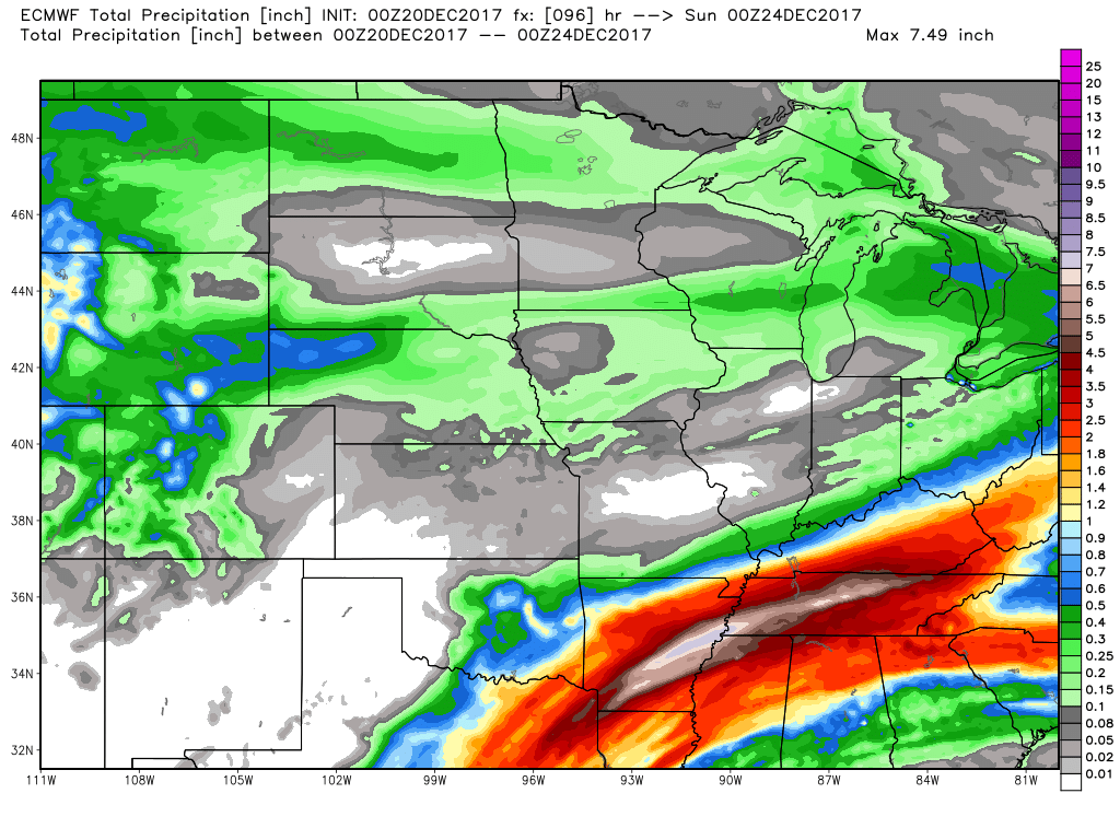
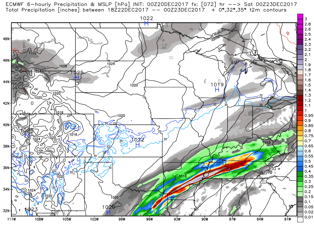
This next map is the EC model guidance. The EC used to be a great model. It has not done all that great lately. This event is an epic bust for the EC guidance. It had a few low over Kansas City. That is not going to verify.
The EC shows a band of very heavy rain along the frontal boundary. It is forecasting a thin band of 3 to 5 inches of rain. This will need to be monitored closely.
.
.
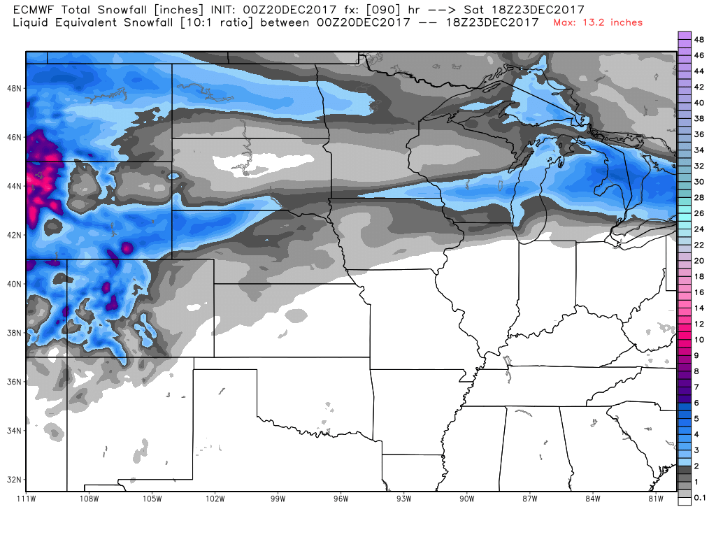
Here is the snowfall forecast from the EC guidance
.
.
All of that adds up to a tricky forecast.
The odds for snow in Missouri and Illinois are greater than Kentucky and Tennessee. If there are shifts in the systems track then forecasts will evolve and change.
Forecasting snow in our region is typically difficult two days in advance. Normally within 24 hours of an event, meteorologists have a better handle on the details.
This system is still in the day two to three range.
If you have travel plans on Friday or Saturday then you will want to monitor updated forecasts.
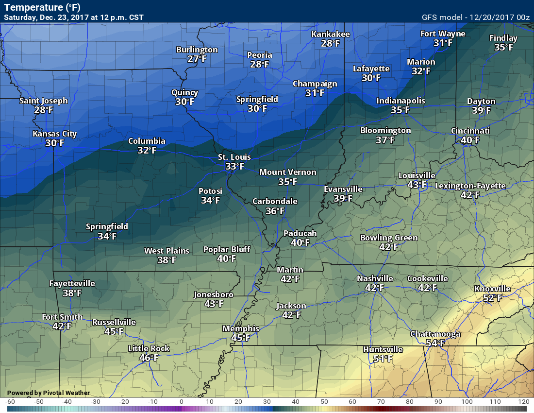
Temperatures on Friday and Saturday will vary based on the placement of the area of low pressure.
Colder air wraps in behind the low. Warmer air ahead of the low.
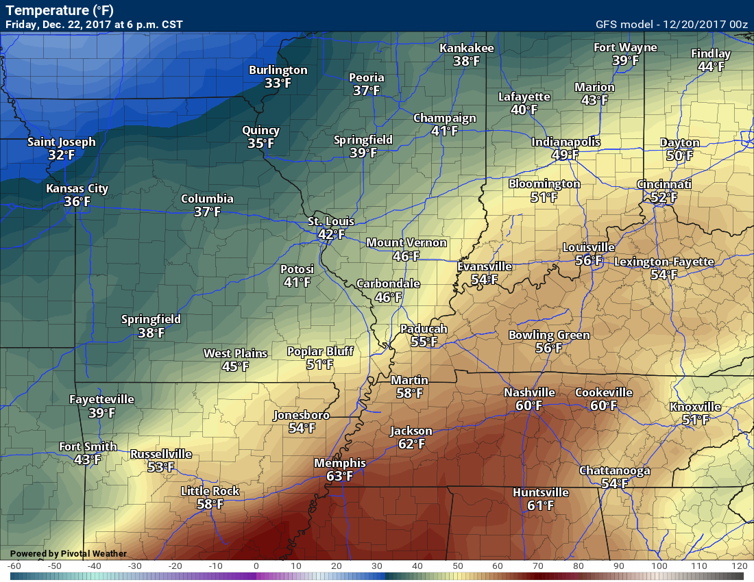
Here is the GFS temperature forecast for Friday at 6 PM
.
.
Saturday at 12 PM
You get the general idea. Warm ahead of the system and cold behind the system.
Those temperature maps will change depending on where this system eventually tracks.
Stay tuned.
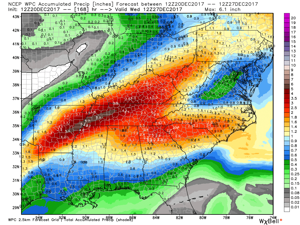
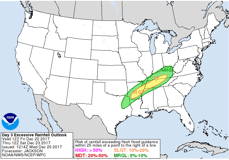
Rainfall totals with the Friday/Saturday system could be heavy. Again, a band of heavy rain is likely to be embedded within the system. The exact track of that heavier band of rain will need to be fine tuned.
The WPC has placed portions of the region in a level two (out of four) risk of excessive rainfall Friday night into Saturday morning.
.
.
Here is the NOAA/WPC rainfall forecast. Notice the stripe over greater than three inch rain totals.
The EC model guidance also shows that heavy band. It has it a bit further south.
.
Christmas Eve and Christmas Day
Some snow flurries or snow showers are possible on Sunday and Sunday night. Right now the risk for accumulation on Sunday and Sunday night appears low.
I can’t completely rule out light accumulation. The best chance of that happening would be over northern portions of the region. Northern southeast Missouri and northern portions of southern Illinois. Again, monitor updates on that system, as well.
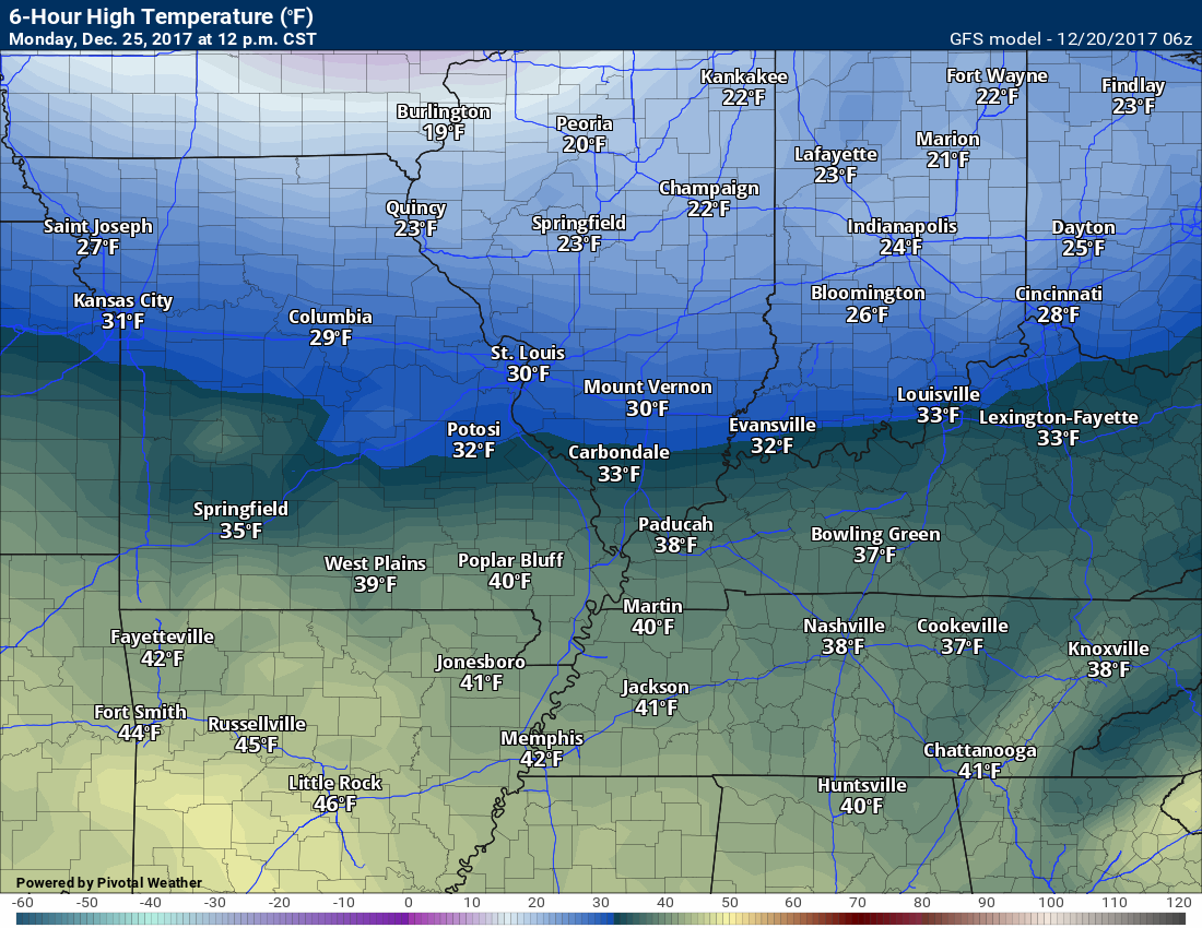
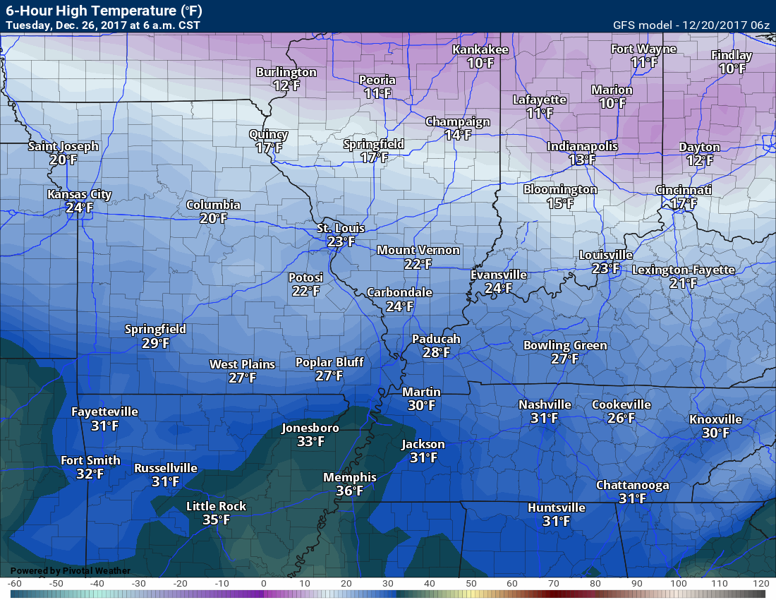
Christmas Day should deliver some sunshine. Perhaps a few passing clouds. Colder. Highs on Christmas Day will likely remain in the 30’s. Lows on Christmas night may dip into the teens.
Here is the GFS temperature map for Christmas Day at 12 PM
.
.
Here is the map for Tuesday morning
.
.
Tuesday through Friday of next week
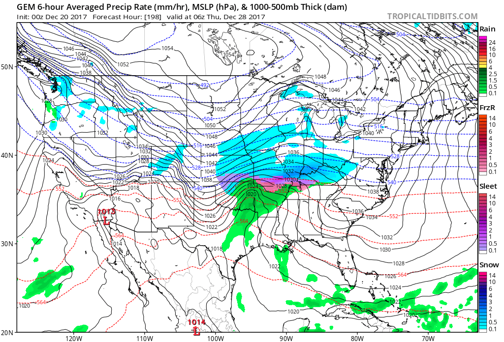
I am monitoring the chance of another storm system around Wednesday or Thursday. Way out in time. Confidence is low. Some of the guidance does indicate another chance for precipitation. It may be cold enough for wintry precipitation. Monitor updates.
The Canadian and GFS guidance is picking up on the potential.
Here is the Canadian model guidance for next Thursday
The Canadian model shows a winter storm in our area. Way too far out for confidence to be all that great. Something worth monitoring.
.
.
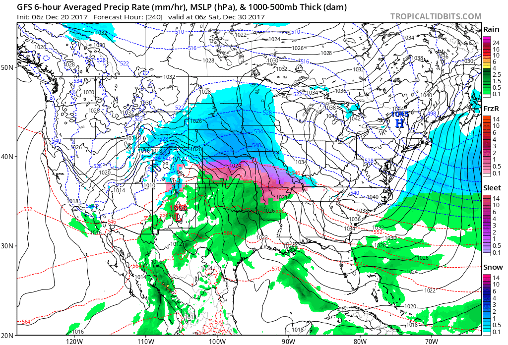
The GFS also shows a system. It brings precipitation into our region Friday or Saturday.
Again way too far out for confidence on the details.
.
.
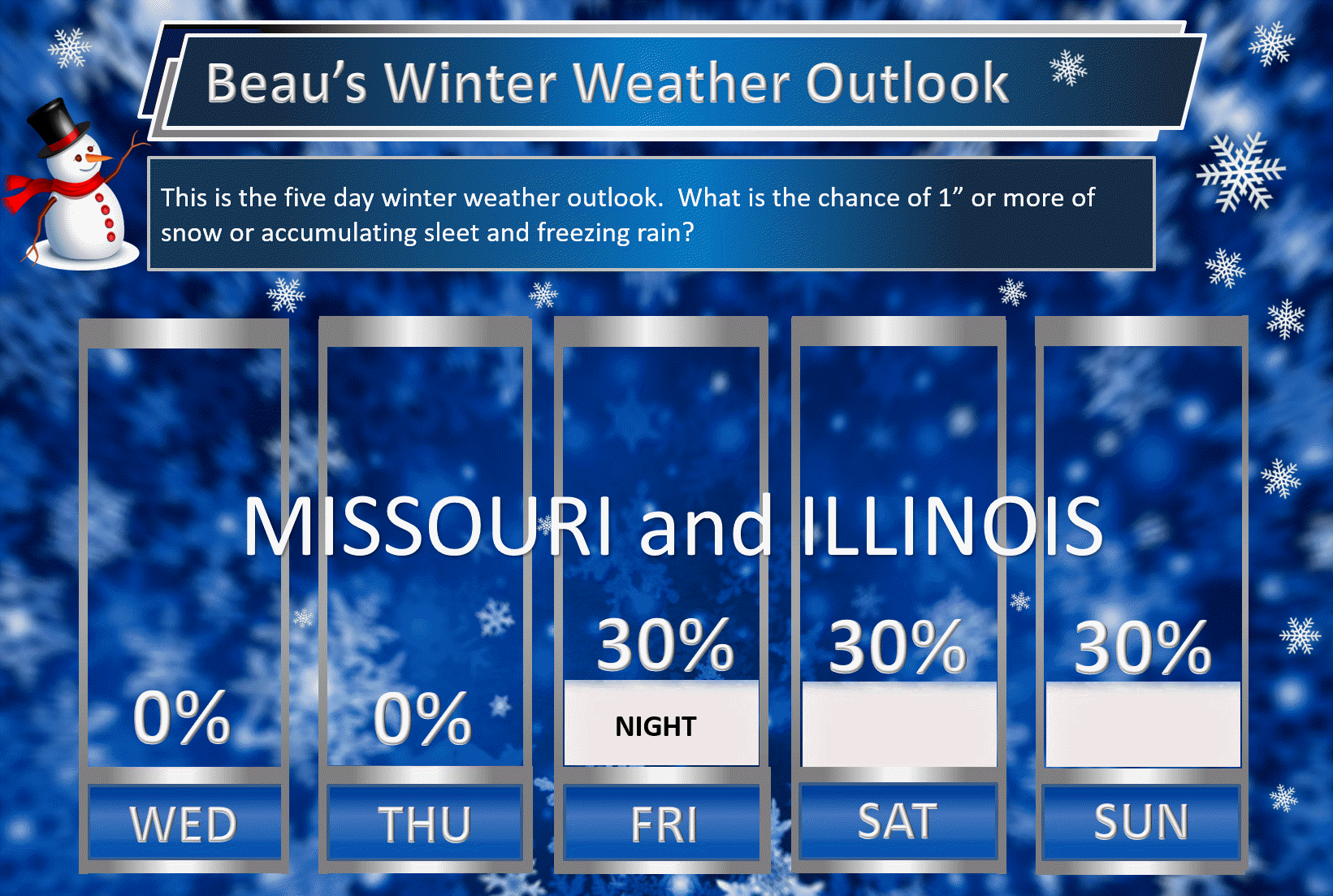
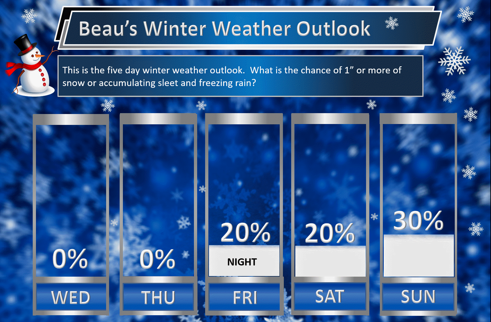
Beau’s Winter Weather Outlook
It is important to remember that this pattern is fluid. There is always going to be lower than normal confidence, during the winter months, for the forecast past day three or four.
.
.
Here are my latest snow probability maps for the week ahead.
These have been updated with the latest data.
These graphics show you the % chance of one inch or more of snow and/or accumulating sleet and freezing rain.
I do not anticipate winter weather through Friday evening. I am monitoring Friday night and Saturday for snow. Low confidence.
Here is the Missouri and Illinois forecast
.
.
Here is the Kentucky and Tennessee forecast
.
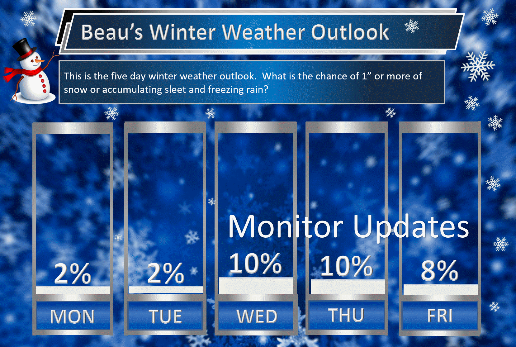
Christmas week. Model guidance shows a very active pattern that could mean multiple precipitation events. Monitor updates moving forward. Confidence is low (it is in the long range).
Keep in mind, I rarely go above 10% chances past day five. That means 10% is a max number for days six through ten.
Let’s keep an eye on the middle/end of next week for another system.
This graphic is for the entire area.
.
.
The pattern remains favorable for wintry weather. The question is going to be storm track and the placement of a boundary in or near our region.
The pattern remains favorable for wintry weather. The question is going to be storm track and the placement of a boundary in or near our region.
.
The pattern remains favorable for wintry weather. The question is going to be storm track and the placement of a boundary in or near our region.
.

We offer regional radars and local city radars – if a radar does not update then try another one. Occasional browsers need their cache cleared. You may also try restarting your browser. This will usually fix any problems.
During the winter you can track snow and ice by clicking the winterize button on the local city view interactive radars.
You may email me at beaudodson@usawx.com
Interactive Weather Radar Page. Choose the city nearest your location: Click this link
National interactive radar: Click this link.


