
Click one of the links below to take you directly to that section
Do you have any suggestions or comments? Email me at beaudodson@usawx.com
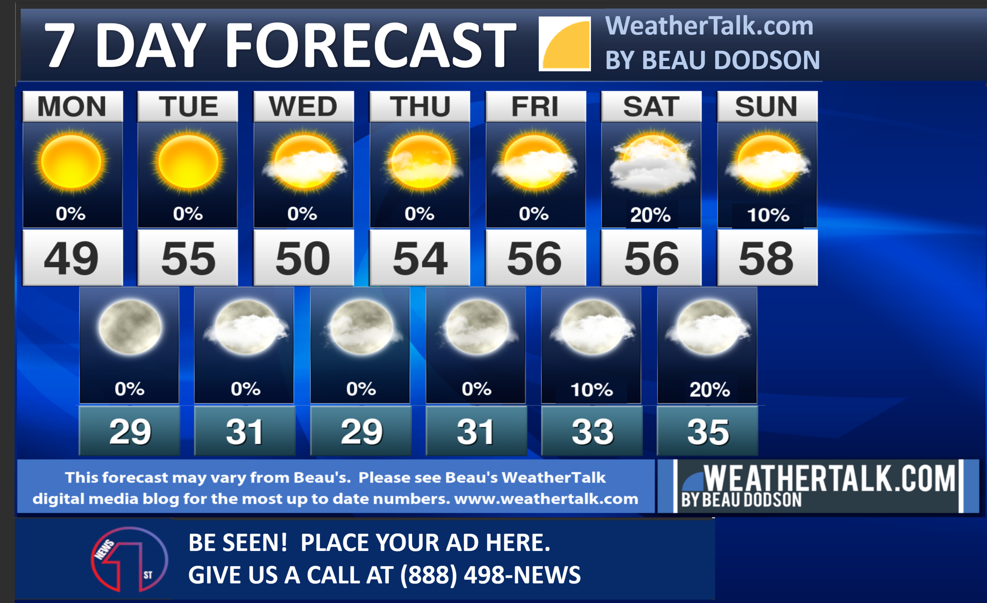
Seven-day forecast for southeast Missouri, southern Illinois, western Kentucky, and western Tennessee.
This is a BLEND for the region. Scroll down to see the region by region forecast.
THE FORECAST IS GOING TO VARY FROM LOCATION TO LOCATION. Scroll down to see the region by region forecast.
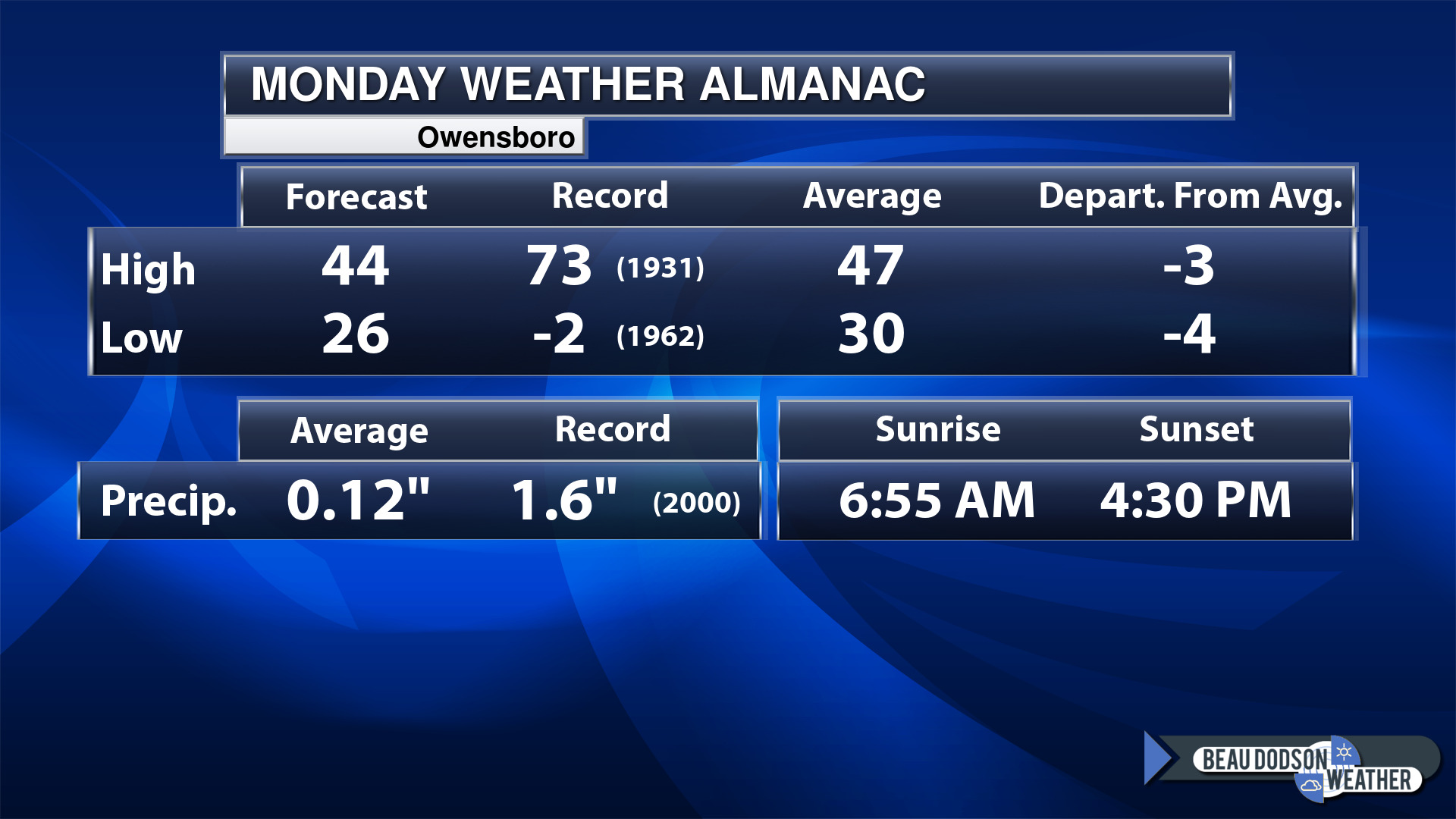
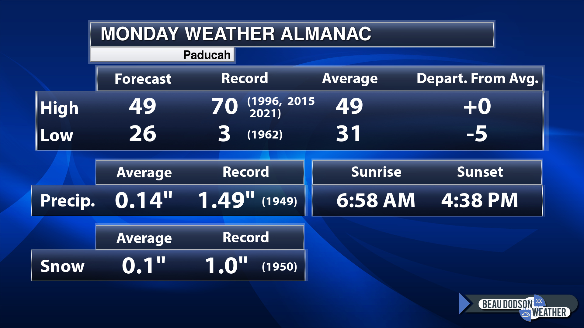
Today’s Local Almanacs (for a few select cities). Your location will be comparable.
Note, the low is this morning’s low and not tomorrows.
Today’s almanac numbers from a few select local cities.
The forecast temperature shows you today’s expected high and this morning’s low.
The graphic shows you the record high and record low for today. It shows you what year that occurred, as well.
It then shows you what today’s average temperature is.
Then, it shows you the departures (how may degrees above or below average temperatures will be ).
It shows you the average precipitation for today. Average comes from thirty years of rain totals.
It also shows you the record rainfall for the date and what year that occurred.
The sunrise and sunset are also shown.
If you have not subscribed to my YouTube Channel then click on this link and it will take you to my videos.
Click the button below and it will take you to the Beau Dodson YouTube Channel.
48-hour forecast


.

.
Monday to Monday
1. Is lightning in the forecast? No.
2. Are severe thunderstorms in the forecast? No.
3. Is flash flooding in the forecast? No.
4. Will the heat index exceed 100 degrees? No.
5. Will the wind chill dip below 10 degrees? No.
6. Is measurable snow and/or sleet in the forecast? No.
7. Is freezing rain/ice in the forecast? No.
Freezing rain is rain that falls and instantly freezes on objects such as trees and power lines
.
Fire weather risk level.
Monday: 5. Medium risk.
Monday night: 5. Medium risk.
Tuesday: 5. Medium risk.
Tuesday night: 5. Medium risk.
Fire Weather Discussion
Dry weather is anticipated through much of this week as high pressure dominates the weather pattern. The next small chance of rain hold off until next weekend. Poor to fair smoke dispersion today will become firmly poor on Tuesday as wind transport decreases within a more shallow mixing layer.
A Haines Index of 6 means a high potential for an existing fire to become large or exhibit erratic fire behavior, 5 means medium potential, 4 means low potential, and anything less than 4 means very low potential.
.
.
Monday, December 11, 2023
Confidence in the forecast? High Confidence
Monday Forecast: Mostly sunny.
What is the chance of precipitation?
Far northern southeast Missouri ~ 0%
Southeast Missouri ~ 0%
The Missouri Bootheel ~ 0%
I-64 Corridor of southern Illinois ~ 0%
Southern Illinois ~ 0%
Extreme southern Illinois (southern seven counties) ~ 0%
Far western Kentucky (Purchase area) ~ 0%
The Pennyrile area of western KY ~ 0%
Northwest Kentucky (near Indiana border) ~ 0%
Northwest Tennessee ~ 0%
Coverage of precipitation:
Timing of the precipitation:
Far northern southeast Missouri ~ 46° to 48°
Southeast Missouri ~ 46° to 48°
The Missouri Bootheel ~ 48° to 50°
I-64 Corridor of southern Illinois ~ 46° to 48°
Southern Illinois ~ 46° to 48°
Extreme southern Illinois (southern seven counties) ~ 46° to 48°
Far western Kentucky ~ 48° to 50°
The Pennyrile area of western KY ~ 48° to 50°
Northwest Kentucky (near Indiana border) ~ 48° to 50°
Northwest Tennessee ~ 48° to 50°
Winds will be from this direction: South southwest 7 to 14 mph
Wind chill or heat index (feels like) temperature forecast: 45° to 50°
What impacts are anticipated from the weather?
Should I cancel my outdoor plans? No
UV Index: 2. Low.
Sunrise: 6:59 AM
Sunset: 4:33 PM
.
Monday Night Forecast: Mostly clear.
What is the chance of precipitation?
Far northern southeast Missouri ~ 0%
Southeast Missouri ~ 0%
The Missouri Bootheel ~ 0%
I-64 Corridor of southern Illinois ~ 0%
Southern Illinois ~ 0%
Extreme southern Illinois (southern seven counties) ~ 0%
Far western Kentucky (Purchase area) ~ 0%
The Pennyrile area of western KY ~ 0%
Northwest Kentucky (near Indiana border) ~ 0%
Northwest Tennessee ~ 0%
Coverage of precipitation:
Timing of the precipitation:
Temperature range:
Far northern southeast Missouri ~ 26° to 30°
Southeast Missouri ~ 26° to 30°
The Missouri Bootheel ~ 28° to 32°
I-64 Corridor of southern Illinois ~ 26° to 30°
Southern Illinois ~ 26° to 30°
Extreme southern Illinois (southern seven counties) ~ 28° to 32°
Far western Kentucky ~ 28° to 32°
The Pennyrile area of western KY ~ 28° to 32°
Northwest Kentucky (near Indiana border) ~ 28° to 32°
Northwest Tennessee ~ 28° to 32°
Winds will be from this direction: South southwest 6 to 12 mph
Wind chill or heat index (feels like) temperature forecast: 25° to 30°
What impacts are anticipated from the weather?
Should I cancel my outdoor plans? No
Moonrise: 5:42 AM
Moonset: 3:24 PM
The phase of the moon: Waning Crescent
.
Tuesday, December 12, 2023
Confidence in the forecast? High Confidence
Tuesday Forecast: Mostly sunny.
What is the chance of precipitation?
Far northern southeast Missouri ~ 0%
Southeast Missouri ~ 0%
The Missouri Bootheel ~ 0%
I-64 Corridor of southern Illinois ~ 0%
Southern Illinois ~ 0%
Extreme southern Illinois (southern seven counties) ~ 0%
Far western Kentucky (Purchase area) ~ 0%
The Pennyrile area of western KY ~ 0%
Northwest Kentucky (near Indiana border) ~ 0%
Northwest Tennessee ~ 0%
Coverage of precipitation:
Timing of the precipitation:
Far northern southeast Missouri ~ 52° to 55°
Southeast Missouri ~ 53° to 56°
The Missouri Bootheel ~ 52° to 55°
I-64 Corridor of southern Illinois ~ 52° to 55°
Southern Illinois ~ 52° to 55°
Extreme southern Illinois (southern seven counties) ~ 53° to 56°
Far western Kentucky ~ 53° to 56°
The Pennyrile area of western KY ~ 53° to 56°
Northwest Kentucky (near Indiana border) ~ 53° to 56°
Northwest Tennessee ~ 53° to 56°
Winds will be from this direction: South southwest 7 to 14 mph
Wind chill or heat index (feels like) temperature forecast: 48° to 52°
What impacts are anticipated from the weather?
Should I cancel my outdoor plans? No
UV Index: 2. Low.
Sunrise: 7:00 AM
Sunset: 4:38 PM
.
Tuesday Night Forecast: Increasing clouds.
What is the chance of precipitation?
Far northern southeast Missouri ~ 0%
Southeast Missouri ~ 0%
The Missouri Bootheel ~ 0%
I-64 Corridor of southern Illinois ~ 0%
Southern Illinois ~ 0%
Extreme southern Illinois (southern seven counties) ~ 0%
Far western Kentucky (Purchase area) ~ 0%
The Pennyrile area of western KY ~ 0%
Northwest Kentucky (near Indiana border) ~ 0%
Northwest Tennessee ~ 0%
Coverage of precipitation:
Timing of the precipitation:
Temperature range:
Far northern southeast Missouri ~ 28° to 32°
Southeast Missouri ~ 28° to 32°
The Missouri Bootheel ~ 28° to 32°
I-64 Corridor of southern Illinois ~ 26° to 30°
Southern Illinois ~ 26° to 30°
Extreme southern Illinois (southern seven counties) ~ 28° to 32°
Far western Kentucky ~ 28° to 32°
The Pennyrile area of western KY ~ 28° to 32°
Northwest Kentucky (near Indiana border) ~ 28° to 32°
Northwest Tennessee ~ 28° to 32°
Winds will be from this direction: Becoming north northwest 6 to 12 mph
Wind chill or heat index (feels like) temperature forecast: 25° to 30°
What impacts are anticipated from the weather?
Should I cancel my outdoor plans? No
Moonrise: 6:52 AM
Moonset: 4:11 PM
The phase of the moon: New
.
Wednesday, December 13, 2023
Confidence in the forecast? High Confidence
Wednesday Forecast: Partly sunny.
What is the chance of precipitation?
Far northern southeast Missouri ~ 0%
Southeast Missouri ~ 0%
The Missouri Bootheel ~ 0%
I-64 Corridor of southern Illinois ~ 0%
Southern Illinois ~ 0%
Extreme southern Illinois (southern seven counties) ~ 0%
Far western Kentucky (Purchase area) ~ 0%
The Pennyrile area of western KY ~ 0%
Northwest Kentucky (near Indiana border) ~ 0%
Northwest Tennessee ~ 0%
Coverage of precipitation:
Timing of the precipitation:
Far northern southeast Missouri ~ 46° to 50°
Southeast Missouri ~ 46° to 50°
The Missouri Bootheel ~ 48° to 52°
I-64 Corridor of southern Illinois ~ 46° to 50°
Southern Illinois ~ 48° to 52°
Extreme southern Illinois (southern seven counties) ~ 48° to 52°
Far western Kentucky ~ 50° to 52°
The Pennyrile area of western KY ~ 50° to 52°
Northwest Kentucky (near Indiana border) ~ 48° to 52°
Northwest Tennessee ~ 50° to 52°
Winds will be from this direction: North 6 to 12 mph
Wind chill or heat index (feels like) temperature forecast: 48° to 52°
What impacts are anticipated from the weather?
Should I cancel my outdoor plans? No
UV Index: 2. Low.
Sunrise: 7:01 AM
Sunset: 4:38 PM
.
Wednesday Night Forecast: Mostly clear.
What is the chance of precipitation?
Far northern southeast Missouri ~ 0%
Southeast Missouri ~ 0%
The Missouri Bootheel ~ 0%
I-64 Corridor of southern Illinois ~ 0%
Southern Illinois ~ 0%
Extreme southern Illinois (southern seven counties) ~ 0%
Far western Kentucky (Purchase area) ~ 0%
The Pennyrile area of western KY ~ 0%
Northwest Kentucky (near Indiana border) ~ 0%
Northwest Tennessee ~ 0%
Coverage of precipitation:
Timing of the precipitation:
Temperature range:
Far northern southeast Missouri ~ 25° to 30°
Southeast Missouri ~ 26° to 30°
The Missouri Bootheel ~ 28° to 32°
I-64 Corridor of southern Illinois ~ 26° to 30°
Southern Illinois ~ 26° to 30°
Extreme southern Illinois (southern seven counties) ~ 28° to 32°
Far western Kentucky ~ 28° to 32°
The Pennyrile area of western KY ~ 28° to 32°
Northwest Kentucky (near Indiana border) ~ 28° to 32°
Northwest Tennessee ~ 28° to 32°
Winds will be from this direction: Northeast 6 to 12 mph
Wind chill or heat index (feels like) temperature forecast: 25° to 30°
What impacts are anticipated from the weather?
Should I cancel my outdoor plans? No
Moonrise: 8:00 AM
Moonset: 5:09 PM
The phase of the moon: Waxing Crescent
.
Thursday, December 14, 2023
Confidence in the forecast? High Confidence
Thursday Forecast: Partly sunny.
What is the chance of precipitation?
Far northern southeast Missouri ~ 0%
Southeast Missouri ~ 0%
The Missouri Bootheel ~ 0%
I-64 Corridor of southern Illinois ~ 0%
Southern Illinois ~ 0%
Extreme southern Illinois (southern seven counties) ~ 0%
Far western Kentucky (Purchase area) ~ 0%
The Pennyrile area of western KY ~ 0%
Northwest Kentucky (near Indiana border) ~ 0%
Northwest Tennessee ~ 0%
Coverage of precipitation:
Timing of the precipitation:
Far northern southeast Missouri ~ 46° to 50°
Southeast Missouri ~ 46° to 50°
The Missouri Bootheel ~ 52° to 54°
I-64 Corridor of southern Illinois ~ 46° to 50°
Southern Illinois ~ 48° to 52°
Extreme southern Illinois (southern seven counties) ~ 50° to 52°
Far western Kentucky ~ 50° to 54°
The Pennyrile area of western KY ~ 50° to 54°
Northwest Kentucky (near Indiana border) ~ 48° to 52°
Northwest Tennessee ~ 52° to 54°
Winds will be from this direction: East 7 to 14 mph
Wind chill or heat index (feels like) temperature forecast: 48° to 52°
What impacts are anticipated from the weather?
Should I cancel my outdoor plans? No
UV Index: 2. Low.
Sunrise: 7:01 AM
Sunset: 4:38 PM
.
Thursday Night Forecast: Becoming partly cloudy.
What is the chance of precipitation?
Far northern southeast Missouri ~ 0%
Southeast Missouri ~ 0%
The Missouri Bootheel ~ 0%
I-64 Corridor of southern Illinois ~ 0%
Southern Illinois ~ 0%
Extreme southern Illinois (southern seven counties) ~ 0%
Far western Kentucky (Purchase area) ~ 0%
The Pennyrile area of western KY ~ 0%
Northwest Kentucky (near Indiana border) ~ 0%
Northwest Tennessee ~ 0%
Coverage of precipitation:
Timing of the precipitation:
Temperature range:
Far northern southeast Missouri ~ 28° to 32°
Southeast Missouri ~ 28° to 32°
The Missouri Bootheel ~ 28° to 32°
I-64 Corridor of southern Illinois ~ 28° to 32°
Southern Illinois ~ 28° to 32°
Extreme southern Illinois (southern seven counties) ~ 28° to 32°
Far western Kentucky ~ 28° to 32°
The Pennyrile area of western KY ~ 28° to 32°
Northwest Kentucky (near Indiana border) ~ 28° to 32°
Northwest Tennessee ~ 28° to 32°
Winds will be from this direction: Northeast 6 to 12 mph
Wind chill or heat index (feels like) temperature forecast: 25° to 30°
What impacts are anticipated from the weather?
Should I cancel my outdoor plans? No
Moonrise: 9:01 AM
Moonset: 6:15 PM
The phase of the moon: Waxing Crescent
.
Friday, December 15, 2023
Confidence in the forecast? High Confidence
Friday Forecast: Partly sunny.
What is the chance of precipitation?
Far northern southeast Missouri ~ 0%
Southeast Missouri ~ 0%
The Missouri Bootheel ~ 0%
I-64 Corridor of southern Illinois ~ 0%
Southern Illinois ~ 0%
Extreme southern Illinois (southern seven counties) ~ 0%
Far western Kentucky (Purchase area) ~ 0%
The Pennyrile area of western KY ~ 0%
Northwest Kentucky (near Indiana border) ~ 0%
Northwest Tennessee ~ 0%
Coverage of precipitation:
Timing of the precipitation:
Far northern southeast Missouri ~ 52° to 55°
Southeast Missouri ~ 52° to 55°
The Missouri Bootheel ~53° to 56°
I-64 Corridor of southern Illinois ~ 52° to 55°
Southern Illinois ~ 52° to 55°
Extreme southern Illinois (southern seven counties) ~ 52° to 55°
Far western Kentucky ~ 52° to 55°
The Pennyrile area of western KY ~ 52° to 55°
Northwest Kentucky (near Indiana border) ~ 52° to 55°
Northwest Tennessee ~ 52° to 55°
Winds will be from this direction: Southeast 7 to 14 mph
Wind chill or heat index (feels like) temperature forecast: 50° to 54°
What impacts are anticipated from the weather?
Should I cancel my outdoor plans? No
UV Index: 2. Low.
Sunrise: 7:02 AM
Sunset: 4:38 PM
.
Friday Night Forecast: Partly cloudy. A chance of light showers.
What is the chance of precipitation?
Far northern southeast Missouri ~ 20%
Southeast Missouri ~ 20%
The Missouri Bootheel ~ 20%
I-64 Corridor of southern Illinois ~ 20%
Southern Illinois ~ 20%
Extreme southern Illinois (southern seven counties) ~ 20%
Far western Kentucky (Purchase area) ~ 20%
The Pennyrile area of western KY ~ 20%
Northwest Kentucky (near Indiana border) ~ 20%
Northwest Tennessee ~ 20%
Coverage of precipitation: Scattered
Timing of the precipitation: After 9 PM
Temperature range:
Far northern southeast Missouri ~ 33° to 36°
Southeast Missouri ~ 33° to 36°
The Missouri Bootheel ~ 36° to 40°
I-64 Corridor of southern Illinois ~ 33° to 36°
Southern Illinois ~ 33° to 36°
Extreme southern Illinois (southern seven counties) ~ 36° to 40°
Far western Kentucky ~ 36° to 40°
The Pennyrile area of western KY ~ 36° to 40°
Northwest Kentucky (near Indiana border) ~ 36° to 40°
Northwest Tennessee ~ 36° to 40°
Winds will be from this direction: Northeast 6 to 12 mph
Wind chill or heat index (feels like) temperature forecast: 32° to 36°
What impacts are anticipated from the weather? Wet roadways.
Should I cancel my outdoor plans? No, but monitor the Beau Dodson Weather Radars
Moonrise: 9:53 AM
Moonset: 7:31 PM
The phase of the moon: Waxing Crescent
.
Click here if you would like to return to the top of the page.
-
- Quiet weather.
- Slow warming trend.
- Monitoring several systems in the long range.
Weather advice:
Make sure you have three to five ways of receiving your severe weather information.
.Forecast Discussion
The good news is the weatherman will rest this week. No significant weather concerns.
A few clouds from time to time. Seasonal temperatures today and tomorrow Warming trend mid to late week (above average temps).
There is a 10% to 20% chance of light showers this weekend. I almost left the chance out, but kept it in for now. It is possible that system simply ends up dry.
.
Click here if you would like to return to the top of the page.
This outlook covers southeast Missouri, southern Illinois, western Kentucky, and far northwest Tennessee.
.
Today’s Storm Prediction Center’s Severe Weather Outlook
Light green is where thunderstorms may occur but should be below severe levels.
Dark green is a level one risk. Yellow is a level two risk. Orange is a level three (enhanced) risk. Red is a level four (moderate) risk. Pink is a level five (high) risk.
One is the lowest risk. Five is the highest risk.
A severe storm is one that produces 58 mph wind or higher, quarter size hail, and/or a tornado.
Explanation of tables. Click here.

.
Tornado Probability Outlook

.
Large Hail Probability Outlook

.
High wind Probability Outlook

.
Tomorrow’s severe weather outlook.

.
Day Three Severe Weather Outlook

.

.
The images below are from NOAA’s Weather Prediction Center.
24-hour precipitation outlook..
 .
.
.
48-hour precipitation outlook.
. .
.
![]()
_______________________________________
.

Click here if you would like to return to the top of the page.
Again, as a reminder, these are models. They are never 100% accurate. Take the general idea from them.
What should I take from these?
- The general idea and not specifics. Models usually do well with the generalities.
- The time-stamp is located in the upper left corner.
.
What am I looking at?
You are looking at computer model data. Meteorologists use many different models to forecast the weather.
Occasionally, these maps are in Zulu time. 12z=7 AM. 18z=1 PM. 00z=7 PM. 06z=1 AM
Green represents light rain. Dark green represents moderate rain. Yellow and orange represent heavier rain.
.
This animation is the NAM Model.
Occasionally, these maps are in Zulu time. 12z=6 AM. 18z=12 PM. 00z=6 PM. 06z=12 AM
Double click images to enlarge them.
.
This animation is the WSF NSSL Model.
Occasionally, these maps are in Zulu time. 12z=6 AM. 18z=12 PM. 00z=6 PM. 06z=12 AM
Double click images to enlarge them.
.
This animation is the EC Model.
Occasionally, these maps are in Zulu time. 12z=6 AM. 18z=12 PM. 00z=6 PM. 06z=12 AM
Double click images to enlarge them.
.
This animation is the NAM 3K Model.
Occasionally, these maps are in Zulu time. 12z=6 AM. 18z=12 PM. 00z=6 PM. 06z=12 AM
Double click images to enlarge them.
..![]()

.
Click here if you would like to return to the top of the page.
.Average high temperatures for this time of the year are around 90 degrees.
Average low temperatures for this time of the year are around 70 degrees.
Average precipitation during this time period ranges from 0.90″ to 1.20″
Six to Ten Day Outlook.
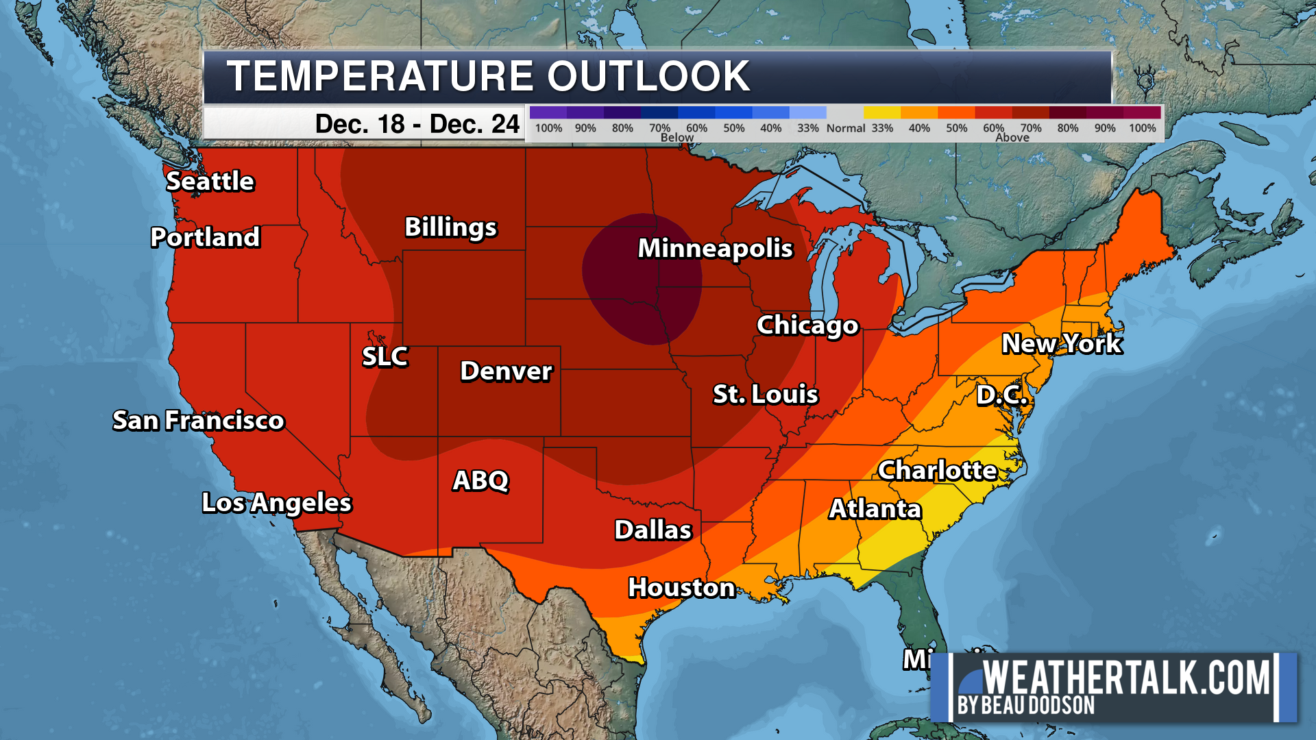
Blue is below average. Red is above average. The no color zone represents equal chances.
Average highs for this time of the year are in the lower 60s. Average lows for this time of the year are in the lower 40s.
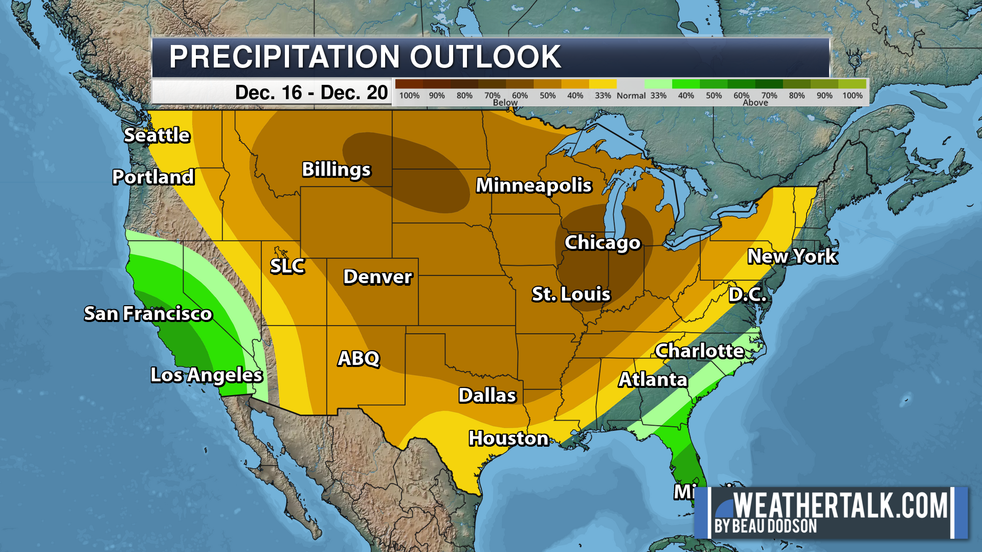
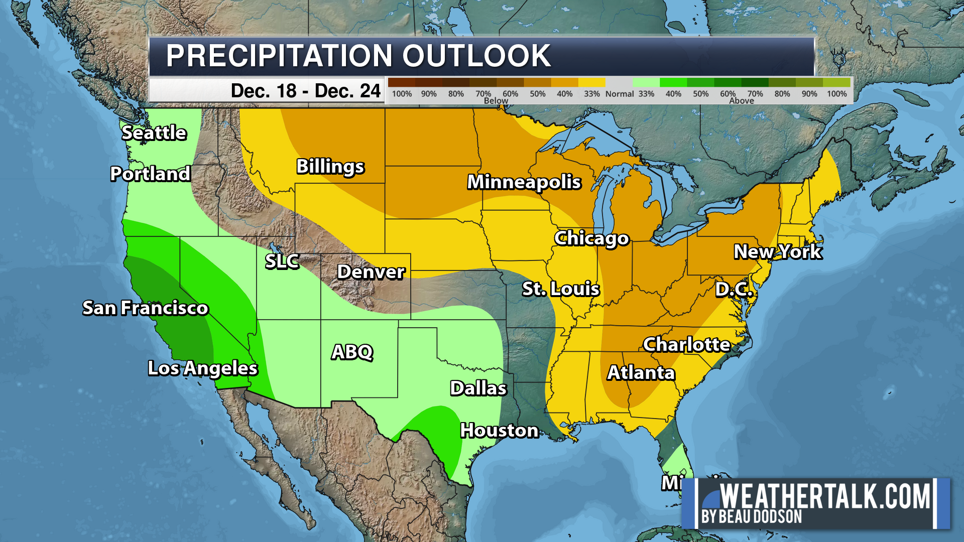
Green is above average precipitation. Yellow and brown favors below average precipitation. Average precipitation for this time of the year is around one inch per week.
.

Average low temperatures for this time of the year are around 70 degrees.
Average precipitation during this time period ranges from 0.90″ to 1.20″
.
.
![]()
The app is for subscribers. Subscribe at www.weathertalk.com/welcome then go to your app store and search for WeatherTalk
Subscribers, PLEASE USE THE APP. ATT and Verizon are not reliable during severe weather. They are delaying text messages.
The app is under WeatherTalk in the app store.
Apple users click here
Android users click here
.

Radars and Lightning Data
Interactive-city-view radars. Clickable watches and warnings.
https://wtalk.co/B3XHASFZ
If the radar is not updating then try another one. If a radar does not appear to be refreshing then hit Ctrl F5. You may also try restarting your browser.
Backup radar site in case the above one is not working.
https://weathertalk.com/morani
Regional Radar
https://imagery.weathertalk.com/prx/RadarLoop.mp4
** NEW ** Zoom radar with chaser tracking abilities!
ZoomRadar
Lightning Data (zoom in and out of your local area)
https://wtalk.co/WJ3SN5UZ
Not working? Email me at beaudodson@usawx.com
National map of weather watches and warnings. Click here.
Storm Prediction Center. Click here.
Weather Prediction Center. Click here.
.

Live lightning data: Click here.
Real time lightning data (another one) https://map.blitzortung.org/#5.02/37.95/-86.99
Our new Zoom radar with storm chases
.
.

Interactive GOES R satellite. Track clouds. Click here.
GOES 16 slider tool. Click here.
College of DuPage satellites. Click here
.

Here are the latest local river stage forecast numbers Click Here.
Here are the latest lake stage forecast numbers for Kentucky Lake and Lake Barkley Click Here.
.
.
Find Beau on Facebook! Click the banner.







 .
.