

.
I have some question-and-answer threads over on the Facebook page. Link to those threads CLICK HERE
Or email me at beaudodsonweather@gmail.com
..

🌪️ Seven-Day Tornado Outlook ⛈️
August 20th through August 27th
Current risk: NONE.
Current confidence level: High confidence in the forecast.
Comments: We are not anticipating tornadoes.
.

Seven-Day Hazardous Weather Outlook
1. Is lightning in the forecast? LOW CHANCE. A low chance of lightning today across the Missouri Bootheel and northwest Tennessee.
2. Are organized/widespread severe thunderstorms in the forecast? NO.
3. Is flash flooding in the forecast? NO.
4. Will non-thunderstorm winds top 40 mph? NO.
5. Will temperatures rise above 90 degrees? POSSIBLE. A few locations could hit 90 degrees today. A few locations could hit 90 degrees on Saturday.
6. Will temperatures rise above 100 degrees? NO.
7. Will the heat index (feels like) rise above 100 degrees? NO.
8. Will the heat index rise above 115 degrees? NO.
.
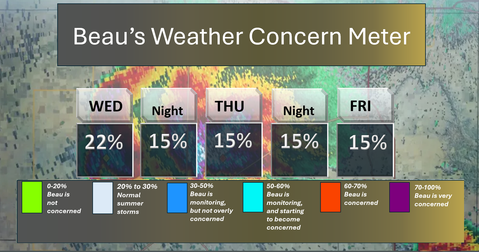
Here is the short-range concern meter.
A few thunderstorms are possible today across the Missouri Bootheel and northwest Tennessee. The chance is 10 to 20%. No severe concerns.
.
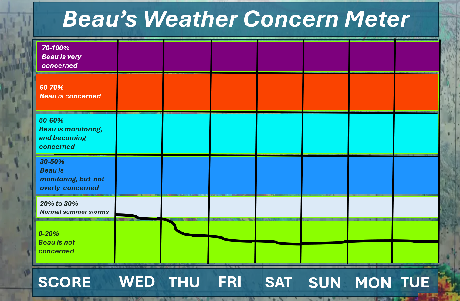
Here is the extended concern meter. This takes us through Tuesday.
Organized or widespread extreme weather is not anticipated.
A few thunderstorms will be possible today across the Missouri Bootheel and northwest Tennessee. Typical summer storms
A quick forecast glance. Your 48-hour forecast Graphics


.
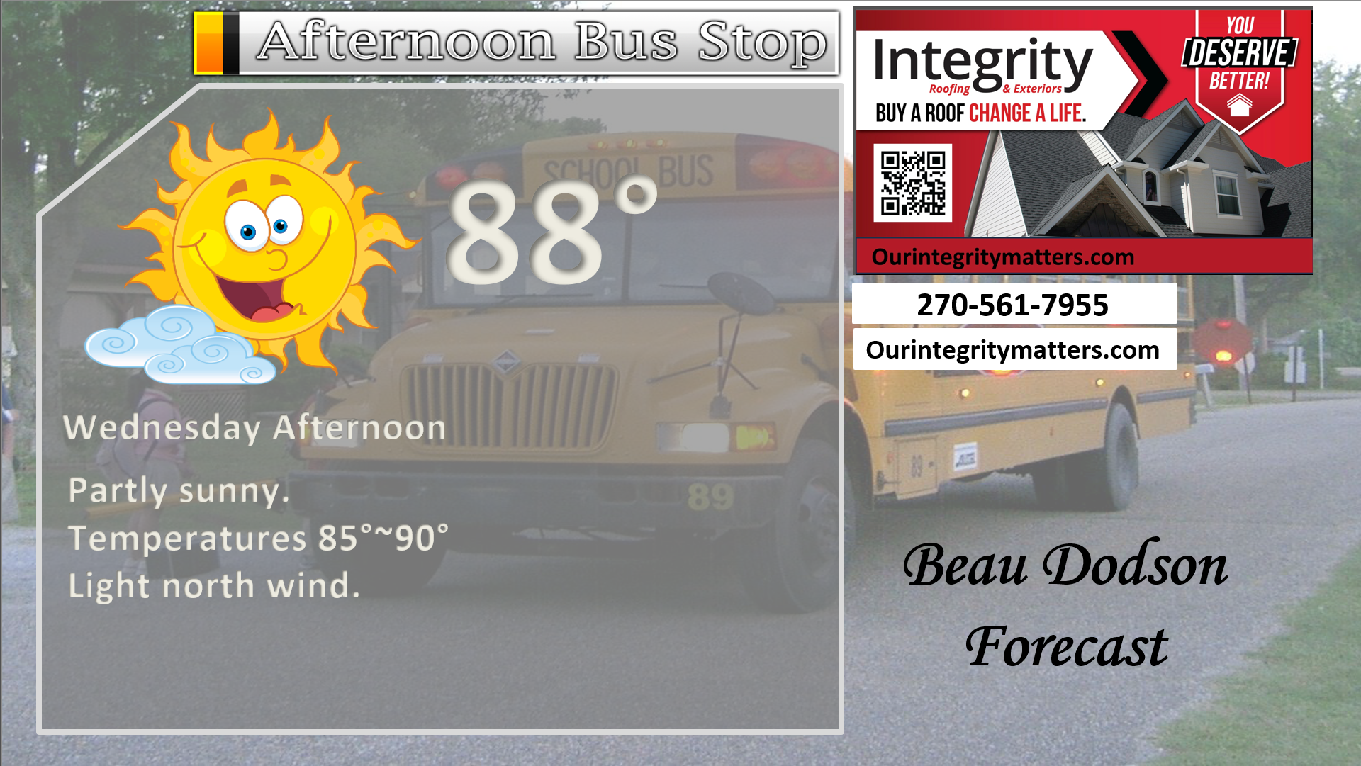
Here is your bus stop forecast.
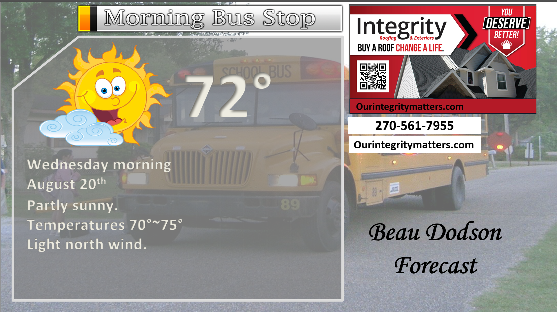
This afternoon
.

.

Forecast discussion.
- Somewhat cooler air is filtering into the region. The cold front is now draped across our far southern counties. It is moving south.
- A few thunderstorms are possible again today across the Missouri Bootheel and northwest Tennessee. We do not expect severe weather.
- Another cold front arrives on Saturday night and Sunday. This will bring even cooler air into the region.
- Next week is shaping up to be nice (much nicer than this week).
.

The cold front is now south of our region. That is the good news.
Some of you experienced heavy local downpours yesterday. There were a handful of damaging wind reports. About what was expected from the marginal risk of severe weather. Typical for August.
Damage was mostly confined to tree limbs and power lines. I did see one report of a garage door blown in and some shingles off a roof.
The chance of thunderstorms today is low and will be confined to the Missouri Bootheel and northwest Tennessee. North of there should be dry. Even in those locations, the chance of thunderstorms will be on the lower end (10% to 20%). No severe concerns.
Dry conditions will prevail tonight through at least next Tuesday.
Another cold front will bring a cooler shot of air to the region by Saturday night and Sunday.
Some locations may remain in the upper 70s next week with lows in the 50s. Won’t that be nice.
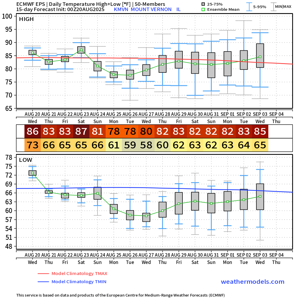
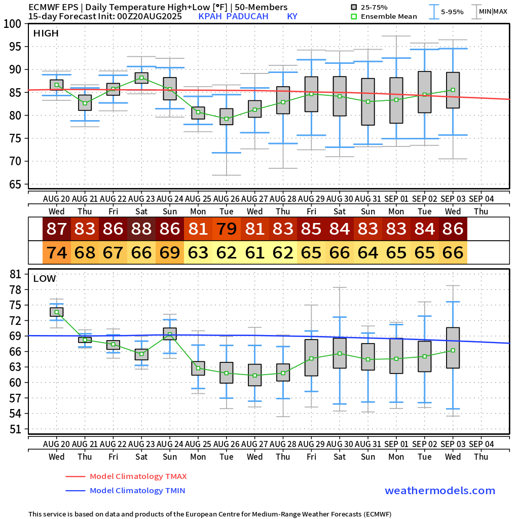
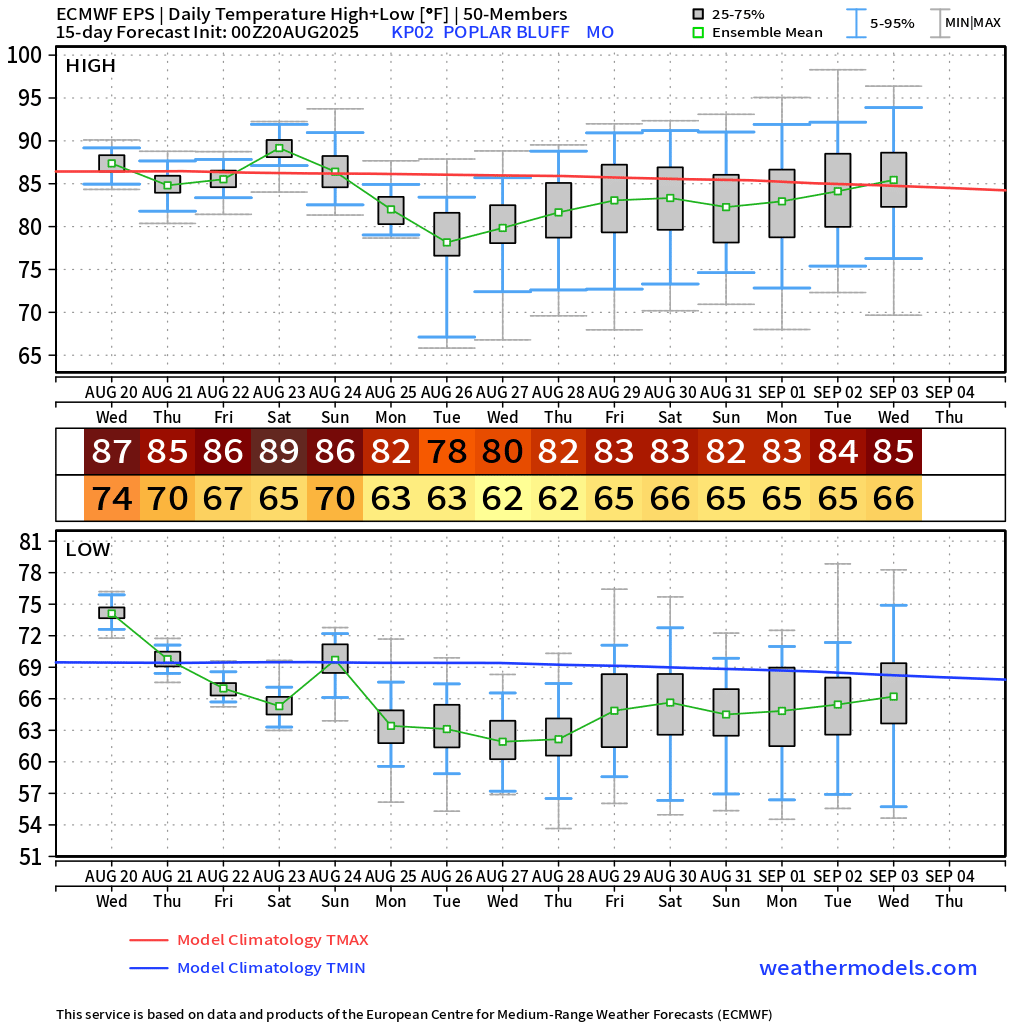
Let me show you the latest EC ensembles. I chose a few local towns.
Check out the cooler air that is on the way, as promised!
You will notice a big difference by Saturday night and Sunday onward. Is the worst of summer behind us? That is certainly possible.
Mt Vernon, Illinois
.
Paducah, Kentucky
.
Poplar Bluff, Missouri
.
Hurricane Erin continues to churn in the Atlantic. No change to the going forecasts from the past week. This thing will stay offshore and move out to sea.
There could be some impacts on the immediate East Coast. Perhaps a few bands of showers and storms. High sea conditions. Beach erosion. Rip currents.
All those pages, over the last few weeks, trying to scare people in Florida and on the East Coast, were once again nothing but hype. This is why we advise you to follow trusted sources rather than fly-by-night pages, which are usually run by non-meteorologists.
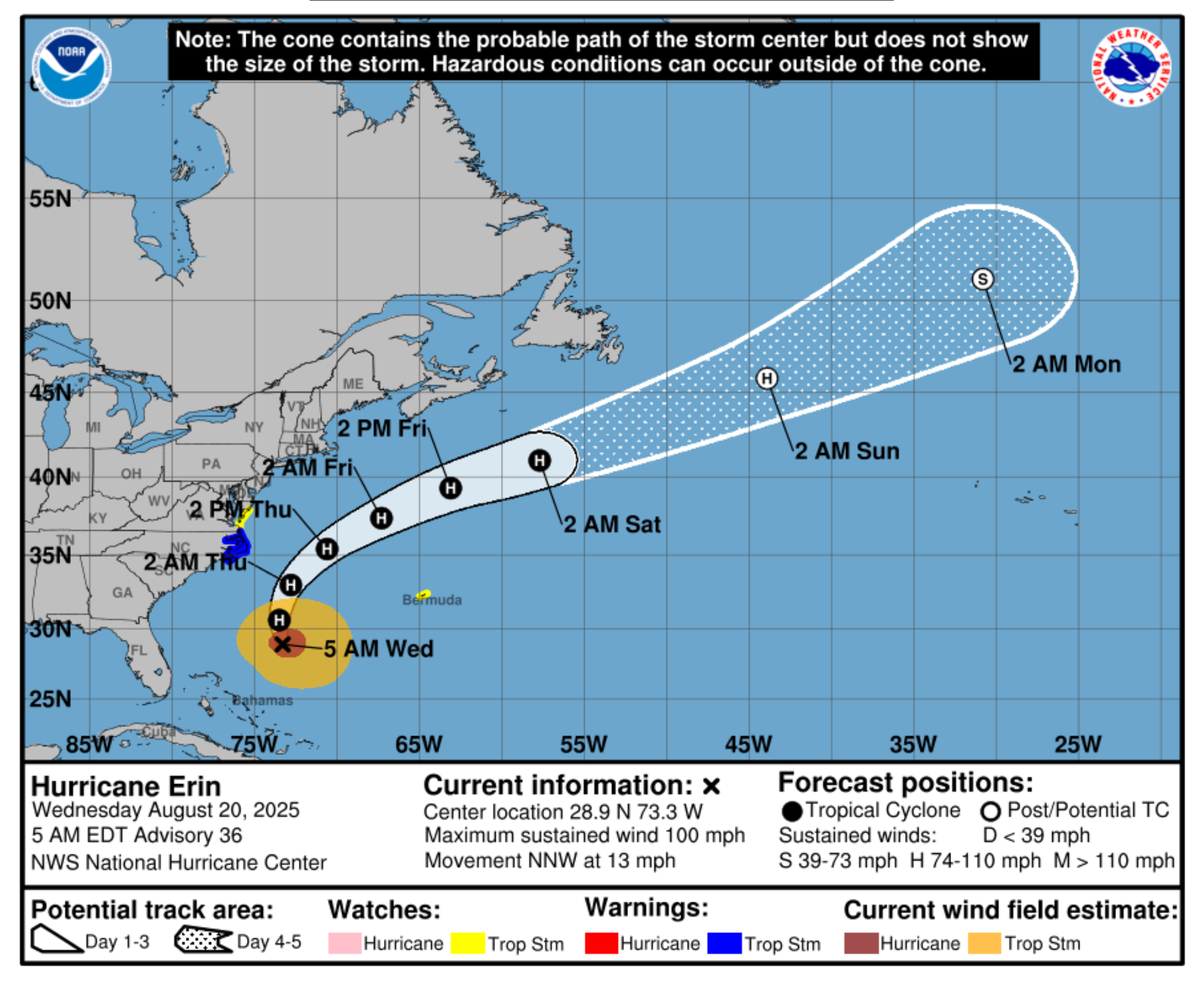
There are no tropical concerns for the Gulf through day seven. The Gulf remains very warm. If a system does get into the Gulf, then we would need to watch it closely.
For now, no concerns!

.
The timestamp (upper left) is in Zulu. 12z=7 am. 18z=1 pm. 00z=7 pm.
Double-click the animation to enlarge it.
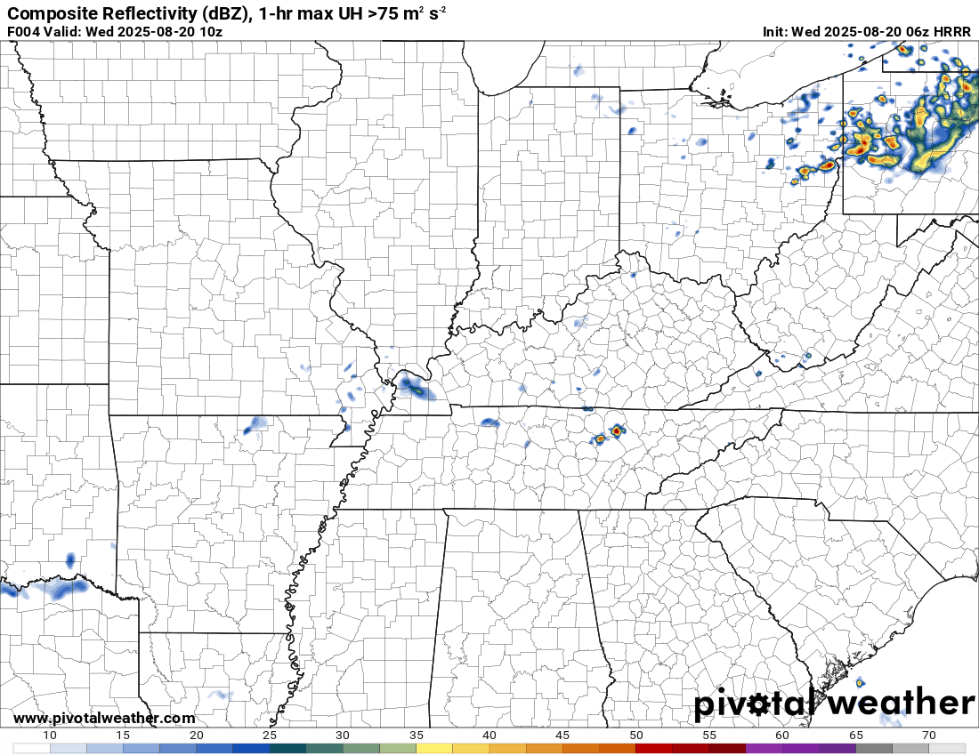
Hrrr model
.
The timestamp (upper left) is in Zulu. 12z=7 am. 18z=1 pm. 00z=7 pm.
Double-click the animation to enlarge it.
NAM model
..
.
Click here if you would like to return to the top of the page.
.Average high temperatures for this time of the year are around 90 degrees.
Average low temperatures for this time of the year are around 68 degrees.
Average precipitation during this time period ranges from 1.00″ to 1.25″
Six to Ten Day Outlook.
Blue is below average. Red is above average. The no color zone represents equal chances.
Average highs for this time of the year are in the lower 60s. Average lows for this time of the year are in the lower 40s.

Green is above average precipitation. Yellow and brown favors below average precipitation. Average precipitation for this time of the year is around one inch per week.

.

Average low temperatures for this time of the year are around 67 degrees.
Average precipitation during this time period ranges from 1.00″ to 1.25″
.
Eight to Fourteen Day Outlook.
Blue is below average. Red is above average. The no color zone represents equal chances.

Green is above average precipitation. Yellow and brown favors below average precipitation. Average precipitation for this time of the year is around one inch per week.

.
.
.
We have a new service to complement your www.weathertalk.com subscription. This does NOTreplace www.weathertalk.com It is simply another tool for you to receive severe weather information.
.
https://weathercallservices.com/beau-dodson-weather


Want to receive the daily forecast/other products on your Beau Dodson Weather app?
Did you know you have four options in your www.weathertalk.com account
You will then receive these via your Beau Dodson Weather app.
Just log into your www.weathertalk.com account
Click the NOTIFICATION SETTINGS TAB
Then, turn them on (green) and off (red)
🌪️ Number 1 is the most important one. Severe alerts, tornado alerts, and so on.
Number 2 is the daily video, blog, livestream alerts, and severe weather Facebook threads on severe days or winter storm days.
Number 3 is the daily forecast. I send that out every day during the afternoon hours. It is the seven-day forecast, hazardous weather outlook, fire outlook, and more.
Number 4 is to receive the daily video, blog, and other content on NON-severe weather days (every day without severe threats in other words)
GREEN IS ON
RED IS OFF

I am going to start going live during bigger severe weather events.
Check it out here https://www.youtube.com/user/beaudodson
Click the subscribe button (it’s a free subscription button), and it will alert you when I go live. I will also send out alerts to the app when I go live for an event.

.

Radars and Lightning Data
Interactive-city-view radars. Clickable watches and warnings.
https://wtalk.co/B3XHASFZ
Old legacy radar site (some of you like it better)
https://weatherobservatory.com/weather-radar.htm
If the radar is not updating then try another one. If a radar does not appear to be refreshing then hit Ctrl F5. You may also try restarting your browser.
Backup radar site in case the above one is not working.
https://weathertalk.com/morani
Regional Radar
https://imagery.weathertalk.com/prx/RadarLoop.mp4
** NEW ** Zoom radar with chaser tracking abilities!
ZoomRadar
If the radar is not working, then email me: Email me at beaudodson@usawx.com
.
We do have some sponsors! Check them out.
Roof damage from recent storms? Link – Click here
INTEGRITY ROOFING AND EXTERIORS!
⛈️ Roof or gutter damage from recent storms? Today’s weather is sponsored by Integrity Roofing. Check out their website at this link https://www.ourintegritymatters.com/

![]()
![]()
![]()
Make sure you have three to five ways of receiving your severe weather information.
Weather Talk is one of those ways! Now, I have another product for you and your family.

.
Want to add more products to your Beau Dodson Weather App?
Receive daily videos, weather blog updates on normal weather days and severe weather and winter storm days, your county by county weather forecast, and more!
Here is how to do add those additional products to your app notification settings!
Here is a video on how to update your Beau Dodson Weather payment.
The app is for subscribers. Subscribe at www.weathertalk.com/welcome then go to your app store and search for WeatherTalk
Subscribers, PLEASE USE THE APP. ATT and Verizon are not reliable during severe weather. They are delaying text messages.
The app is under WeatherTalk in the app store.

Apple users click here

Android users click here
.
Radars and Lightning Data
Interactive-city-view radars. Clickable watches and warnings.
https://wtalk.co/B3XHASFZ
Old legacy radar site (some of you like it better)
https://weatherobservatory.com/weather-radar.htm
If the radar is not updating then try another one. If a radar does not appear to be refreshing then hit Ctrl F5. You may also try restarting your browser.
Backup radar site in case the above one is not working.
https://weathertalk.com/morani
Regional Radar
https://imagery.weathertalk.com/prx/RadarLoop.mp4
** NEW ** Zoom radar with chaser tracking abilities!
ZoomRadar
Lightning Data (zoom in and out of your local area)
https://wtalk.co/WJ3SN5UZ
Not working? Email me at beaudodson@usawx.com
National map of weather watches and warnings. Click here.
Storm Prediction Center. Click here.
Weather Prediction Center. Click here.
.

Live lightning data: Click here.
Real time lightning data (another one) https://map.blitzortung.org/#5.02/37.95/-86.99
Our new Zoom radar with storm chases
.
.

Interactive GOES R satellite. Track clouds. Click here.
GOES 16 slider tool. Click here.
College of DuPage satellites. Click here
.

Here are the latest local river stage forecast numbers Click Here.
Here are the latest lake stage forecast numbers for Kentucky Lake and Lake Barkley Click Here.
.
.
Find Beau on Facebook! Click the banner.


 .
.