
Click one of the links below to take you directly to that section
![]()
![]()
![]()
![]()
![]()
![]()
![]()
.

.
Seven Day Hazardous Weather Outlook
1. Is lightning in the forecast? YES. Isolated lightning is possible today. An even small chance Saturday. I am watching the late next week for a cold front. If that arrives in our region, then lightning would be possible.
2. Are severe thunderstorms in the forecast? NOT AT THIS TIME. I am watching a cold front late next week. This could bring thunderstorms, but it is too early to know if severe weather will be a concern.
3. Is flash flooding in the forecast? NOT AT THIS TIME.
4. Will non-thunderstorm winds top 40 mph? NO.
5. Will temperatures rise above 100 degrees? NO.
6. Will the heat index (feels like temperature) exceed 100 degrees? POSSIBLE. I am monitoring heat index values Tuesday, Wednesday, and Thursday of next week.
7. Will the heat index (feels like temperature) exceed 110 degrees? NOT AT THIS TIME.
8. Will the wind chill dip below 10 degrees? NO.
9. Is measurable snow and/or sleet in the forecast? NO.
10. Is freezing rain/ice in the forecast? NO.
Freezing rain is rain that falls and instantly freezes on objects such as trees and power lines Freezing fog possible, as well.
.
Fire weather risk level.
Friday through Friday night: 4. Low risk.
Saturday: 4. Very low risk.
Saturday night: 5. Medium risk.
Fire Weather Discussion
Isolated showers and storms are possible this afternoon, mainly across southwest IN and the KY Pennyrile. Northwesterly winds and deeper mixing today will result in good dispersion. A long period of dry weather with near to slightly above normal temperatures will begin next weekend and continue into next week.
A Haines Index of 6 means a high potential for an existing fire to become large or exhibit erratic fire behavior, 5 means medium potential, 4 means low potential, and anything less than 4 means very low potential.
.

THE FORECAST IS GOING TO VARY FROM LOCATION TO LOCATION.
Scroll down to see your local forecast details.
Seven-day forecast for southeast Missouri, southern Illinois, western Kentucky, and western Tennessee.
This is a BLEND for the region. Scroll down to see the region by region forecast.
48-hour forecast Graphics


.
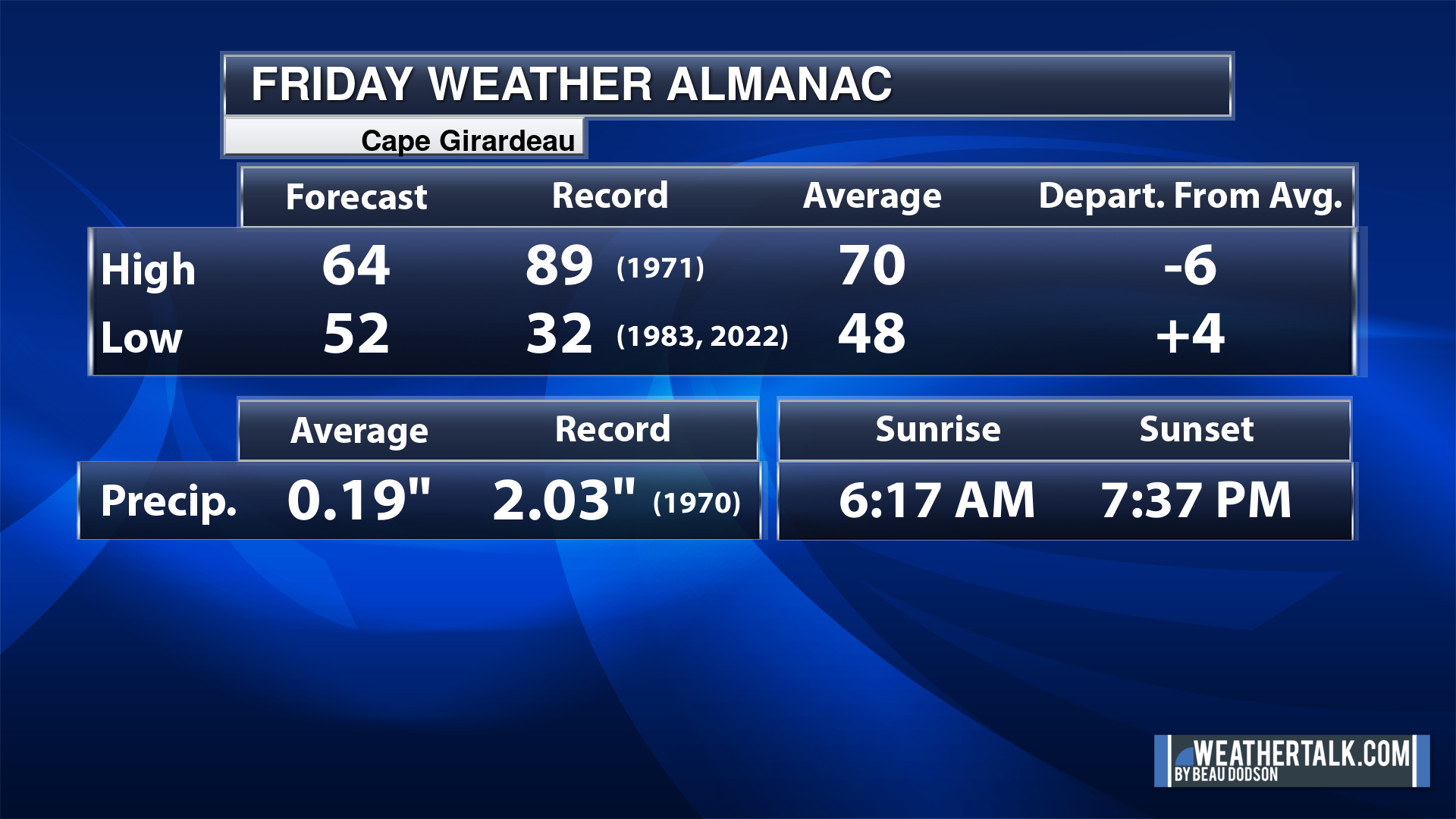
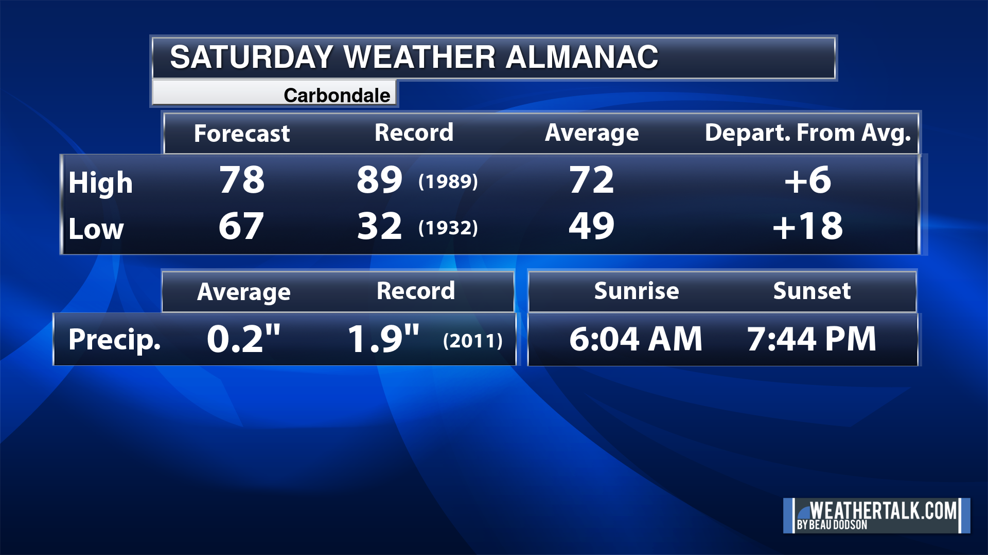
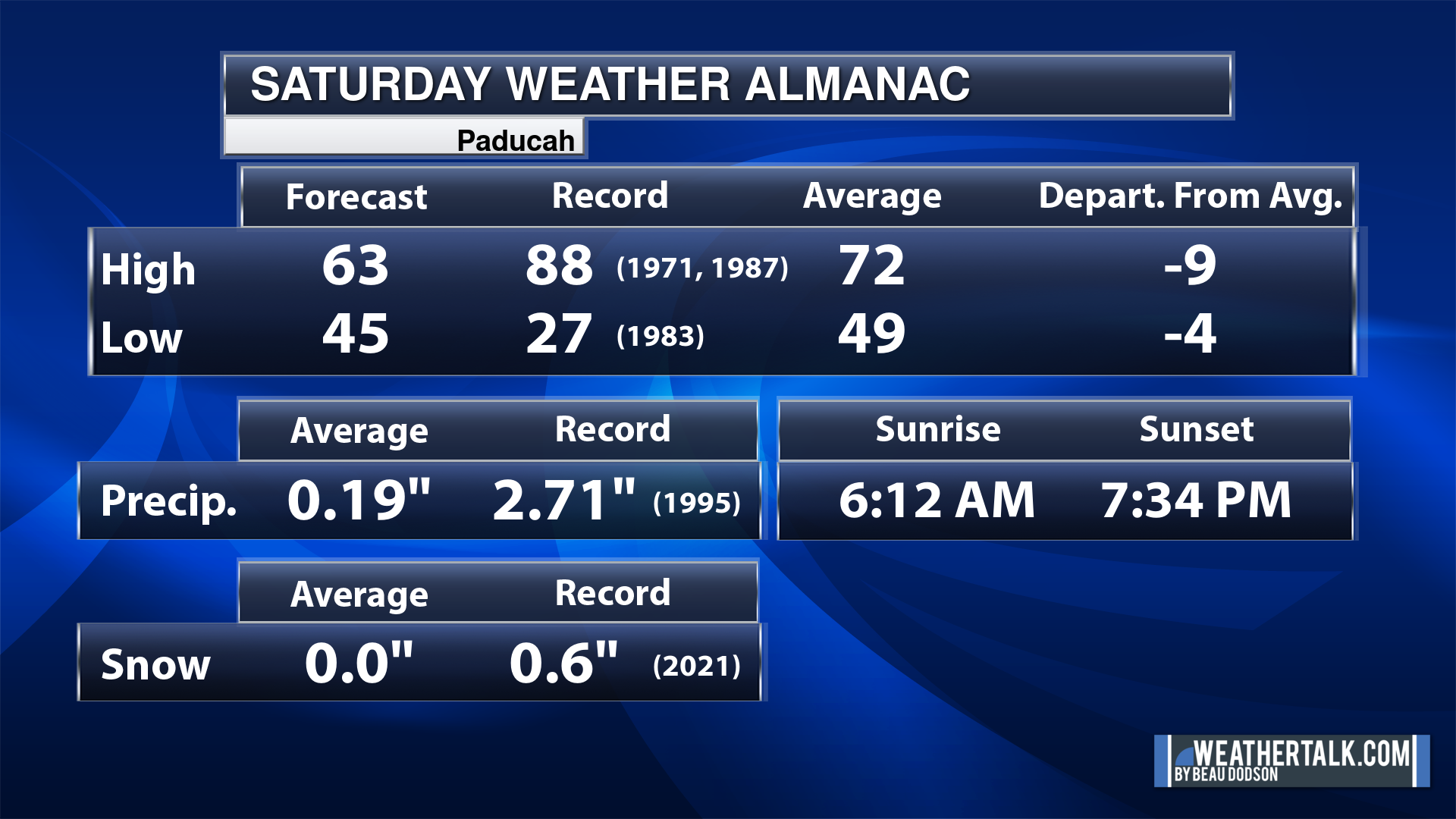
Today’s Local Almanacs (for a few select cities). Your location will be comparable.
Note, the low is this morning’s low and not tomorrows.
The forecast temperature shows you today’s expected high and this morning’s low.
The graphic shows you the record high and record low for today. It shows you what year that occurred, as well.
It then shows you what today’s average temperature is.
It shows you the departures (how may degrees above or below average temperatures will be ).
It shows you the average precipitation for today. Average comes from thirty years of rain totals.
It also shows you the record rainfall for the date and what year that occurred.
The sunrise and sunset are also shown.


![]()
.
.
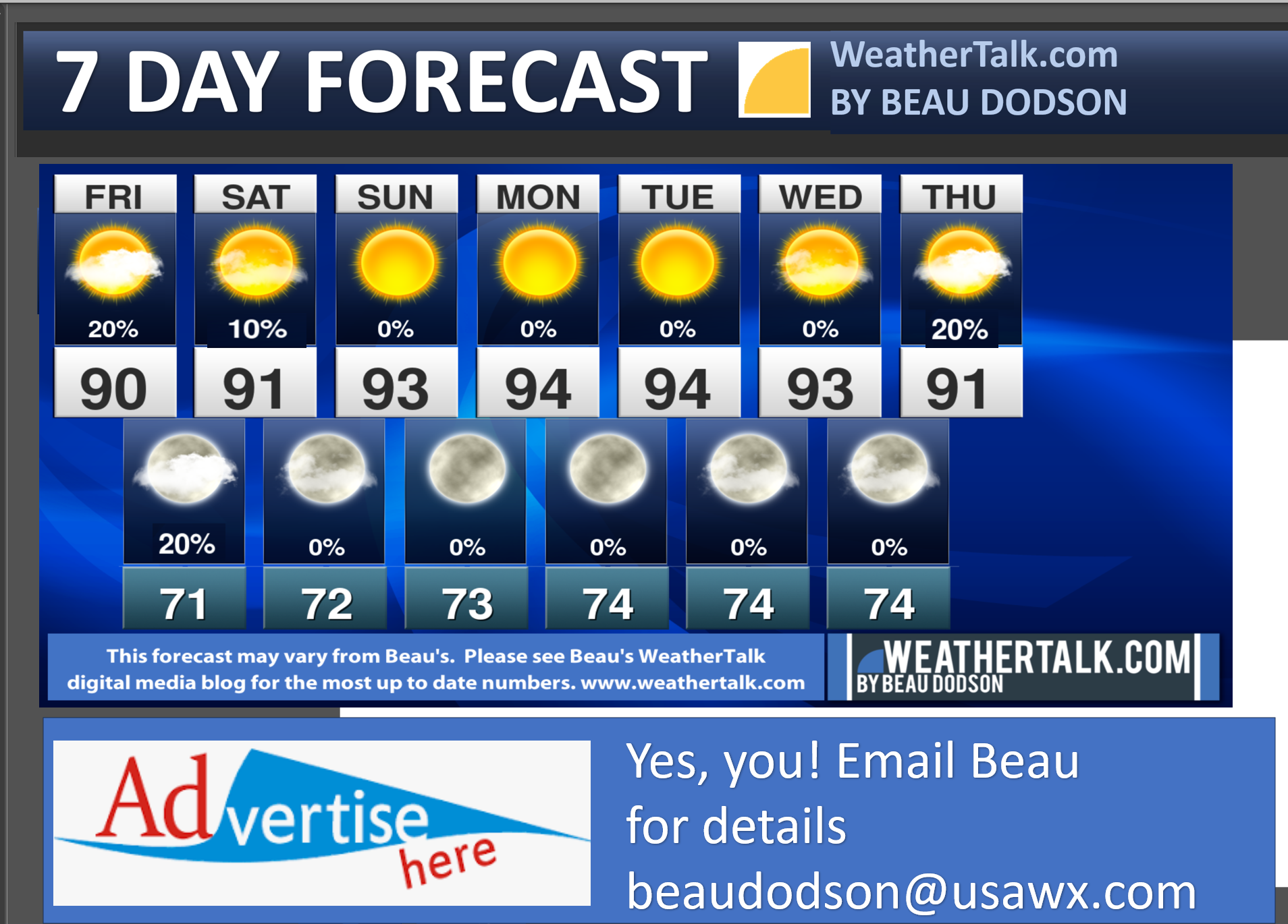
Friday Forecast: Mostly sunny. Warm and humid. A chance of a few thunderstorms.
What is the chance of precipitation?
Far northern southeast Missouri ~ 20%
Southeast Missouri ~ 20%
The Missouri Bootheel ~ 10%
I-64 Corridor of southern Illinois ~ 20%
Southern Illinois ~ 20%
Extreme southern Illinois (southern seven counties) ~ 20%
Far western Kentucky (Purchase area) ~ 30%
The Pennyrile area of western KY ~ 30%
Northwest Kentucky (near Indiana border) ~ 30%
Northwest Tennessee ~ 20%
Coverage of precipitation: Widely scattered
Timing of the precipitation: Mainly this afternoon and evening.
Temperature range:
Far northern southeast Missouri ~ 88° to 92°
Southeast Missouri ~ 90° to 92°
The Missouri Bootheel ~ 90° to 94°
I-64 Corridor of southern Illinois ~ 88° to 92°
Southern Illinois ~ 88° to 92°
Extreme southern Illinois (southern seven counties) ~ 90° to 92°
Far western Kentucky ~ 90° to 92°
The Pennyrile area of western KY ~ 90° to 92°
Northwest Kentucky (near Indiana border) ~ 88° to 92°
Northwest Tennessee ~ 90° to 94°
Winds will be from this direction: W NW at 5 to 10 mph
Wind chill or heat index (feels like) temperature forecast: 90° to 98°
What impacts are anticipated from the weather? Wet roadways. Lightning. Locally heavy rainfall. Some storms could be intense.
Should I cancel my outdoor plans? No, but monitor the Beau Dodson Weather Radars
UV Index: 10. Very high.
Sunrise: 6:01 AM
Sunset: 8:01 PM
.
Friday Night Forecast: Partly cloudy. A chance of a few evening showers and thunderstorms.
What is the chance of precipitation?
Far northern southeast Missouri ~ 10%
Southeast Missouri ~ 10%
The Missouri Bootheel ~ 10%
I-64 Corridor of southern Illinois ~ 20%
Southern Illinois ~ 20%
Extreme southern Illinois (southern seven counties) ~ 20%
Far western Kentucky (Purchase area) ~ 20%
The Pennyrile area of western KY ~ 30%
Northwest Kentucky (near Indiana border) ~ 20%
Northwest Tennessee ~ 20%
Coverage of precipitation: Isolated
Timing of the precipitation: Any given point of time
Temperature range:
Far northern southeast Missouri ~ 68° to 72°
Southeast Missouri ~ 68° to 72°
The Missouri Bootheel ~ 70° to 72°
I-64 Corridor of southern Illinois ~ 68° to 72°
Southern Illinois ~ 68° to 72°
Extreme southern Illinois (southern seven counties) ~ 70° to 72°
Far western Kentucky ~ 70° to 72°
The Pennyrile area of western KY ~ 70° to 72°
Northwest Kentucky (near Indiana border) ~ 70° to 72°
Northwest Tennessee ~ 70° to 72°
Winds will be from this direction: North northeast at 6 to 12 mph
Wind chill or heat index (feels like) temperature forecast: 70° to 72°
What impacts are anticipated from the weather? Wet roadways. Lightning. Locally heavy rainfall. Some storms could be intense.
Should I cancel my outdoor plans? No, but monitor the Beau Dodson Weather Radars
Moonrise: 3:48 AM
Moonset: 7:22 PM
The phase of the moon: Waning Crescent
.
Saturday Forecast: Mostly sunny. Warm and humid.
What is the chance of precipitation?
Far northern southeast Missouri ~ 0%
Southeast Missouri ~ 0%
The Missouri Bootheel ~ 0%
I-64 Corridor of southern Illinois ~ 0%
Southern Illinois ~ 0%
Extreme southern Illinois (southern seven counties) ~ 0%
Far western Kentucky (Purchase area) ~ 10%
The Pennyrile area of western KY ~ 10%
Northwest Kentucky (near Indiana border) ~ 10%
Northwest Tennessee ~ 10%
Coverage of precipitation: Isolated
Timing of the precipitation: Any given point of time.
Temperature range:
Far northern southeast Missouri ~ 88° to 92°
Southeast Missouri ~ 90° to 92°
The Missouri Bootheel ~ 90° to 94°
I-64 Corridor of southern Illinois ~ 88° to 92°
Southern Illinois ~ 88° to 92°
Extreme southern Illinois (southern seven counties) ~ 90° to 92°
Far western Kentucky ~ 90° to 92°
The Pennyrile area of western KY ~ 90° to 92°
Northwest Kentucky (near Indiana border) ~ 88° to 92°
Northwest Tennessee ~ 90° to 94°
Winds will be from this direction: W NW at 5 to 10 mph
Wind chill or heat index (feels like) temperature forecast: 90° to 96°
What impacts are anticipated from the weather? Wet roadways. Lightning.
Should I cancel my outdoor plans? No, but monitor the Beau Dodson Weather Radars
UV Index: 10. Very high.
Sunrise: 6:02 AM
Sunset: 8:00 PM
.
Saturday Night Forecast: Mostly clear.
What is the chance of precipitation?
Far northern southeast Missouri ~ 0%
Southeast Missouri ~ 0%
The Missouri Bootheel ~ 0%
I-64 Corridor of southern Illinois ~ 0%
Southern Illinois ~ 0%
Extreme southern Illinois (southern seven counties) ~ 0%
Far western Kentucky (Purchase area) ~ 10%
The Pennyrile area of western KY ~ 10%
Northwest Kentucky (near Indiana border) ~ 10%
Northwest Tennessee ~ 0%
Coverage of precipitation:
Timing of the precipitation:
Temperature range:
Far northern southeast Missouri ~ 70° to 72°
Southeast Missouri ~ 70° to 72°
The Missouri Bootheel ~ 70° to 72°
I-64 Corridor of southern Illinois ~ 70° to 72°
Southern Illinois ~ 70° to 72°
Extreme southern Illinois (southern seven counties) ~ 70° to 72°
Far western Kentucky ~ 70° to 72°
The Pennyrile area of western KY ~ 70° to 72°
Northwest Kentucky (near Indiana border) ~ 70° to 72°
Northwest Tennessee ~ 70° to 72°
Winds will be from this direction: North northeast at 4 to 8 mph
Wind chill or heat index (feels like) temperature forecast: 70° to 72°
What impacts are anticipated from the weather?
Should I cancel my outdoor plans? No
Moonrise: 4:54 AM
Moonset: 8:00 PM
The phase of the moon: New
.
Sunday Forecast: Mostly sunny.
What is the chance of precipitation?
Far northern southeast Missouri ~ 0%
Southeast Missouri ~ 0%
The Missouri Bootheel ~ 0%
I-64 Corridor of southern Illinois ~ 0%
Southern Illinois ~ 0%
Extreme southern Illinois (southern seven counties) ~ 0%
Far western Kentucky (Purchase area) ~ 0%
The Pennyrile area of western KY ~ 0%
Northwest Kentucky (near Indiana border) ~ 0%
Northwest Tennessee ~ 0%
Coverage of precipitation:
Timing of the precipitation:
Temperature range:
Far northern southeast Missouri ~ 88° to 92°
Southeast Missouri ~ 90° to 92°
The Missouri Bootheel ~ 90° to 94°
I-64 Corridor of southern Illinois ~ 88° to 92°
Southern Illinois ~ 88° to 92°
Extreme southern Illinois (southern seven counties) ~ 90° to 92°
Far western Kentucky ~ 90° to 92°
The Pennyrile area of western KY ~ 90° to 92°
Northwest Kentucky (near Indiana border) ~ 88° to 92°
Northwest Tennessee ~ 90° to 94°
Winds will be from this direction: Variable wind at 5 to 10 mph
Wind chill or heat index (feels like) temperature forecast: 88° to 94°
What impacts are anticipated from the weather?
Should I cancel my outdoor plans? No
UV Index: 10. Very high.
Sunrise: 6:03 AM
Sunset: 7:59 PM
.
Sunday Night Forecast: Mostly clear.
What is the chance of precipitation?
Far northern southeast Missouri ~ 0%
Southeast Missouri ~ 0%
The Missouri Bootheel ~ 0%
I-64 Corridor of southern Illinois ~ 0%
Southern Illinois ~ 0%
Extreme southern Illinois (southern seven counties) ~ 0%
Far western Kentucky (Purchase area) ~ 0%
The Pennyrile area of western KY ~ 0%
Northwest Kentucky (near Indiana border) ~ 0%
Northwest Tennessee ~ 0%
Coverage of precipitation:
Timing of the precipitation:
Temperature range:
Far northern southeast Missouri ~ 70° to 72°
Southeast Missouri ~ 70° to 72°
The Missouri Bootheel ~ 70° to 72°
I-64 Corridor of southern Illinois ~ 70° to 72°
Southern Illinois ~ 70° to 72°
Extreme southern Illinois (southern seven counties) ~ 70° to 72°
Far western Kentucky ~ 70° to 72°
The Pennyrile area of western KY ~ 70° to 72°
Northwest Kentucky (near Indiana border) ~ 70° to 72°
Northwest Tennessee ~ 70° to 72°
Winds will be from this direction: Calm winds
Wind chill or heat index (feels like) temperature forecast: 70° to 72°
What impacts are anticipated from the weather?
Should I cancel my outdoor plans? No
Moonrise: 5:58 AM
Moonset: 8:32 PM
The phase of the moon: New
.
Monday Forecast: Mostly sunny. Warmer.
What is the chance of precipitation?
Far northern southeast Missouri ~ 0%
Southeast Missouri ~ 0%
The Missouri Bootheel ~ 0%
I-64 Corridor of southern Illinois ~ 0%
Southern Illinois ~ 0%
Extreme southern Illinois (southern seven counties) ~ 0%
Far western Kentucky (Purchase area) ~ 0%
The Pennyrile area of western KY ~ 0%
Northwest Kentucky (near Indiana border) ~ 0%
Northwest Tennessee ~ 0%
Coverage of precipitation:
Timing of the precipitation:
Temperature range:
Far northern southeast Missouri ~ 90° to 95°
Southeast Missouri ~ 90° to 95°
The Missouri Bootheel ~ 90° to 95°
I-64 Corridor of southern Illinois ~ 90° to 95°
Southern Illinois ~ 90° to 95°
Extreme southern Illinois (southern seven counties) ~ 90° to 95°
Far western Kentucky ~ 90° to 95°
The Pennyrile area of western KY ~ 90° to 95°
Northwest Kentucky (near Indiana border) ~ 90° to 95°
Northwest Tennessee ~ 90° to 95°
Winds will be from this direction: S SW 4 to 8 mph
Wind chill or heat index (feels like) temperature forecast: 95° to 100°
What impacts are anticipated from the weather?
Should I cancel my outdoor plans? No
UV Index: 10. Very high.
Sunrise: 6:04 AM
Sunset: 7:58 PM
.
Monday Night Forecast: Mostly clear.
What is the chance of precipitation?
Far northern southeast Missouri ~ 0%
Southeast Missouri ~ 0%
The Missouri Bootheel ~ 0%
I-64 Corridor of southern Illinois ~ 0%
Southern Illinois ~ 0%
Extreme southern Illinois (southern seven counties) ~ 0%
Far western Kentucky (Purchase area) ~ 0%
The Pennyrile area of western KY ~ 0%
Northwest Kentucky (near Indiana border) ~ 0%
Northwest Tennessee ~ 0%
Coverage of precipitation:
Timing of the precipitation:
Temperature range:
Far northern southeast Missouri ~ 70° to 72°
Southeast Missouri ~ 70° to 72°
The Missouri Bootheel ~ 70° to 72°
I-64 Corridor of southern Illinois ~ 70° to 72°
Southern Illinois ~ 70° to 72°
Extreme southern Illinois (southern seven counties) ~ 70° to 72°
Far western Kentucky ~ 70° to 72°
The Pennyrile area of western KY ~ 70° to 72°
Northwest Kentucky (near Indiana border) ~ 70° to 72°
Northwest Tennessee ~ 70° to 72°
Winds will be from this direction: Light SW wind
Wind chill or heat index (feels like) temperature forecast: 70° to 72°
What impacts are anticipated from the weather?
Should I cancel my outdoor plans? No
Moonrise: 7:01 AM
Moonset: 8:58 PM
The phase of the moon: Waxing Crescent.
.
Tuesday Forecast: Mostly sunny. Warmer.
What is the chance of precipitation?
Far northern southeast Missouri ~ 0%
Southeast Missouri ~ 0%
The Missouri Bootheel ~ 0%
I-64 Corridor of southern Illinois ~ 0%
Southern Illinois ~ 0%
Extreme southern Illinois (southern seven counties) ~ 0%
Far western Kentucky (Purchase area) ~ 0%
The Pennyrile area of western KY ~ 0%
Northwest Kentucky (near Indiana border) ~ 0%
Northwest Tennessee ~ 0%
Coverage of precipitation:
Timing of the precipitation:
Temperature range:
Far northern southeast Missouri ~ 93° to 96°
Southeast Missouri ~ 93° to 96°
The Missouri Bootheel ~ 93° to 96°
I-64 Corridor of southern Illinois ~ 93° to 96°
Southern Illinois ~ 93° to 96°
Extreme southern Illinois (southern seven counties) ~ 93° to 96°
Far western Kentucky ~ 93° to 96°
The Pennyrile area of western KY ~ 93° to 96°
Northwest Kentucky (near Indiana border) ~ 93° to 96°
Northwest Tennessee ~ 93° to 96°
Winds will be from this direction: S SW 4 to 8 mph
Wind chill or heat index (feels like) temperature forecast: 96° to 102°
What impacts are anticipated from the weather?
Should I cancel my outdoor plans? No
UV Index: 10. Very high.
Sunrise: 6:05 AM
Sunset: 7:57 PM
.
Tuesday Night Forecast: Mostly clear.
What is the chance of precipitation?
Far northern southeast Missouri ~ 0%
Southeast Missouri ~ 0%
The Missouri Bootheel ~ 0%
I-64 Corridor of southern Illinois ~ 0%
Southern Illinois ~ 0%
Extreme southern Illinois (southern seven counties) ~ 0%
Far western Kentucky (Purchase area) ~ 0%
The Pennyrile area of western KY ~ 0%
Northwest Kentucky (near Indiana border) ~ 0%
Northwest Tennessee ~ 0%
Coverage of precipitation:
Timing of the precipitation:
Temperature range:
Far northern southeast Missouri ~ 70° to 72°
Southeast Missouri ~ 70° to 72°
The Missouri Bootheel ~ 70° to 72°
I-64 Corridor of southern Illinois ~ 70° to 72°
Southern Illinois ~ 70° to 72°
Extreme southern Illinois (southern seven counties) ~ 70° to 72°
Far western Kentucky ~ 70° to 72°
The Pennyrile area of western KY ~ 70° to 72°
Northwest Kentucky (near Indiana border) ~ 70° to 72°
Northwest Tennessee ~ 70° to 72°
Winds will be from this direction: Light SW wind
Wind chill or heat index (feels like) temperature forecast: 70° to 72°
What impacts are anticipated from the weather?
Should I cancel my outdoor plans? No
Moonrise: 8:02 AM
Moonset: 9:21 PM
The phase of the moon: Waxing Crescent.
.
.
Click here if you would like to return to the top of the page.

-
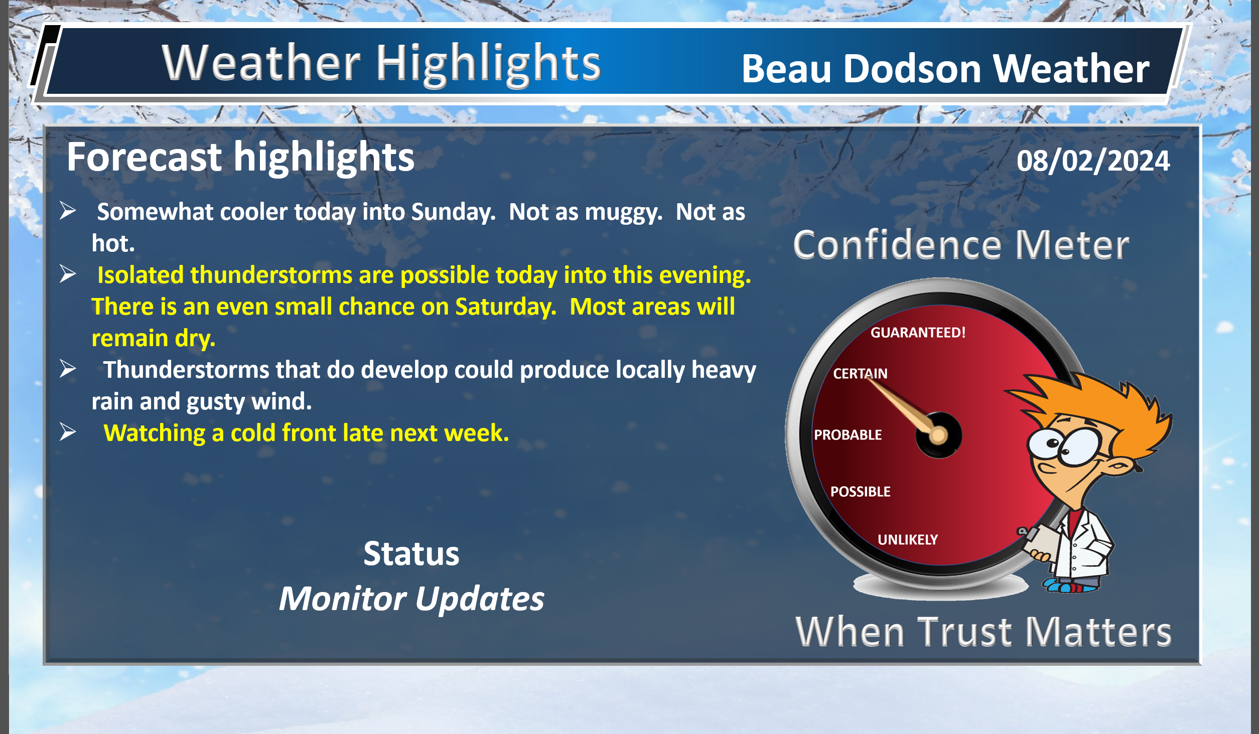
- Not as hot and not as muggy into the weekend.
- Widely scattered thunderstorms this afternoon and evening.
- Hot weather returns next week, but perhaps the heat index values won’t be as extreme as this past week.
- Watching a cold front late next week.
- Watching the tropics.
Weather advice:
Do you have any suggestions or comments? Email me at beaudodson@usawx.com
Make sure you have three to five ways of receiving your severe weather information.
Weather Talk is one of those ways.
.
Beau’s Forecast Discussion
It was a stormy week! Some locations received 5 to 10 inches of rain. Other locations received less than an inch. Another typical summer pattern with numerous thunderstorm clusters.
There was quite a bit of wind damage in the four state area. Even one tornado near Evansville.
Thankfully, the weather will be calmer as we move through today, Saturday, Sunday, Monday, and Tuesday.
It won’t be as extremely muggy today through the weekend. It will still be warm with widespread mid to upper 80s. Some low 90’s mixed in over our southern counties.
Dew points will be a bit lower and that will keep heat index values lower (esp tomorrow and Sunday).
There will be a few thunderstorms dotting radar this afternoon and evening. Most areas will remain dry. A few locations will pick up a quick downpour and gusty wind. Lightning, of course.
Rain chances have been capped between 10% to 30% (30% far eastern counties). That would be mainly this afternoon and evening.
Saturday and Sunday are shaping up to be nice. Not as hot. Not as humid. Only a 10% chance of a thunderstorm on Saturday. Most areas will remain dry.
We begin to see a new warming trend Monday into the middle of next week with widespread 90s returning. Dew points will creep back up, as well. That will lead to heat index values approaching or perhaps exceeding 100 degrees.
I am watching a cold front towards the end of next week. That could bring some thunderstorms and somewhat cooler temperatures.
August has arrived! It is just four short weeks to meteorological autumn! Hard to believe.
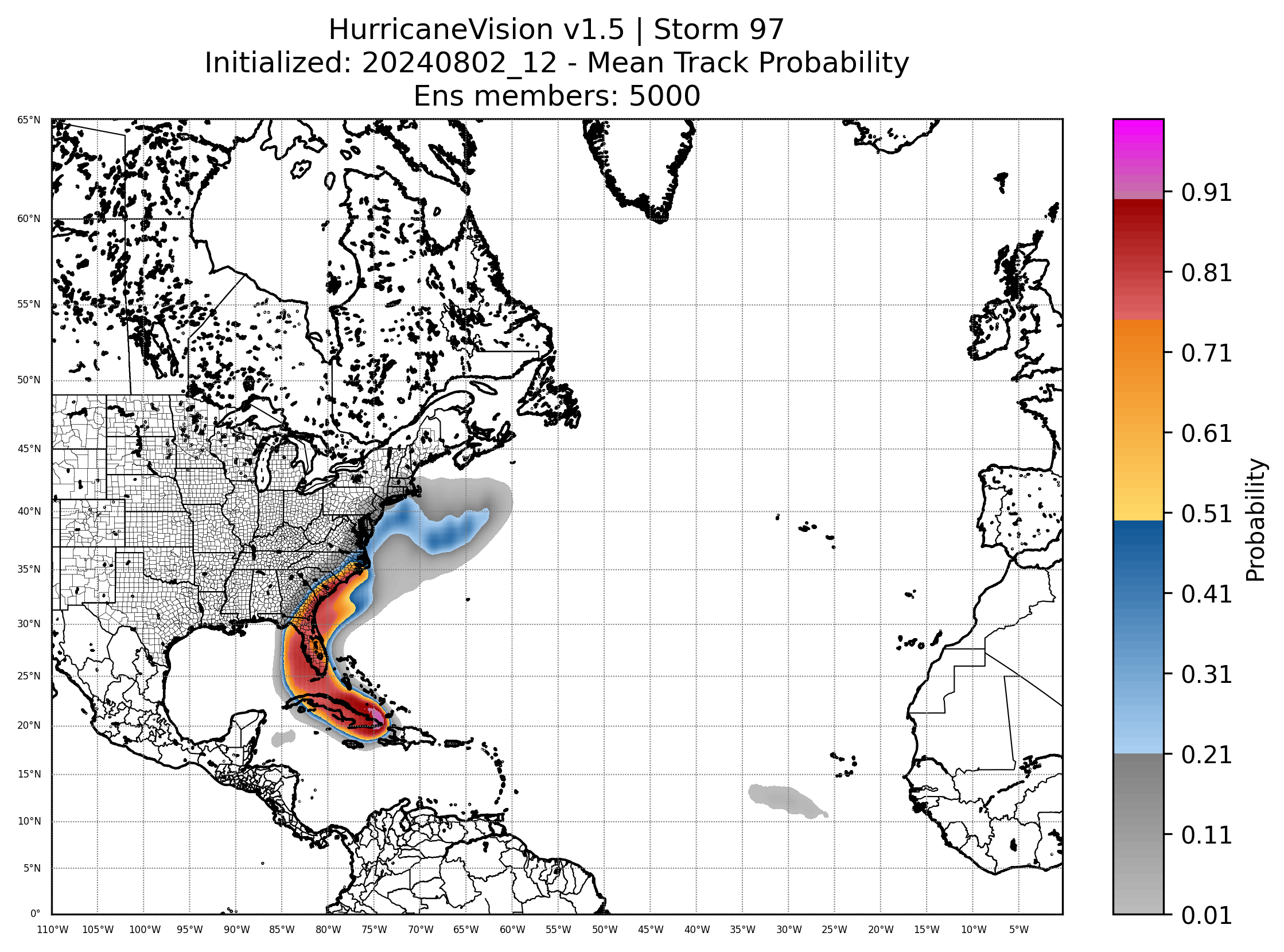
I am watching the tropics this weekend into next week. A disturbance will develop in the Gulf of Mexico and head towards Florida. The primary concern will be heavy rain, short-lived tornadoes, and gusty winds.
It could become a tropical storm. It would then move north northeast and eventually may end up off the southeast U.S. coast.
Here is the potential track path.
![]()
.
Click here if you would like to return to the top of the page.
This outlook covers southeast Missouri, southern Illinois, western Kentucky, and far northwest Tennessee.

.
Today’s Storm Prediction Center’s (SPC) Severe Weather Outlook
Light green is where thunderstorms may occur but should be below severe levels.
Dark green is a level one risk. Yellow is a level two risk. Orange is a level three (enhanced) risk. Red is a level four (moderate) risk. Pink is a level five (high) risk.
One is the lowest risk. Five is the highest risk.
A severe storm is one that produces 58 mph wind or higher, quarter or larger size hail, and/or a tornado.
Explanation of tables. Click here.
Day One Severe Weather Outlook

Day One Severe Weather Outlook. Zoomed in on our region.

.
Day One Tornado Probability Outlook

Day One Regional Tornado Outlook. Zoomed in on our region.

.
Day One Large Hail Probability Outlook

Day One Regional Hail Outlook. Zoomed in on our region.

.
Day One High wind Probability Outlook

Day One Regional Wind Outlook. Zoomed in on our region.

.
Tomorrow’s severe weather outlook. Day two outlook.

Day Two Outlook. Zoomed in on our region.

.
Day Three Severe Weather Outlook

.

.
The images below are from NOAA’s Weather Prediction Center.
24-hour precipitation outlook..
 .
.
.
48-hour precipitation outlook.
. .
.
![]()
_______________________________________
.

Click here if you would like to return to the top of the page.
Again, as a reminder, these are models. They are never 100% accurate. Take the general idea from them.
What should I take from these?
- The general idea and not specifics. Models usually do well with the generalities.
- The time-stamp is located in the upper left corner.
.
What am I looking at?
You are looking at computer model data. Meteorologists use many different models to forecast the weather.
Occasionally, these maps are in Zulu time. 12z=7 AM. 18z=1 PM. 00z=7 PM. 06z=1 AM
Green represents light rain. Dark green represents moderate rain. Yellow and orange represent heavier rain.
.
This animation is the NAM 3K Model.
This graphic shows you what this particular model believes the radar may look like. Each model may be a little different. The more models that agree, the higher the confidence in the forecast outcome.
Occasionally, these maps are in Zulu time. 12z=7 AM. 18z=1 PM. 00z=7 PM. 06z=1 AM
Double click images to enlarge them.
.
This animation is the Hrrr Model.
This graphic shows you what this particular model believes the radar may look like. Each model may be a little different. The more models that agree, the higher the confidence in the forecast outcome.
Green is rain. Yellow and orange are heavier rain. Pink is a wintry mix. Blue is snow. Dark blue is heavier snow.
Occasionally, these maps are in Zulu time. 12z=7 AM. 18z=1 PM. 00z=7 PM. 06z=1 AM
Double click images to enlarge them.
.
This animation is the NSSL Model.
This graphic shows you what this particular model believes the radar may look like. Each model may be a little different. The more models that agree, the higher the confidence in the forecast outcome.
Green is rain. Yellow and orange are heavier rain. Pink is a wintry mix. Blue is snow. Dark blue is heavier snow.
Occasionally, these maps are in Zulu time. 12z=7 AM. 18z=1 PM. 00z=7 PM. 06z=1 AM
Double click images to enlarge them.
.
This animation is the GFS Model.
This graphic shows you what this particular model believes the radar may look like. Each model may be a little different. The more models that agree, the higher the confidence in the forecast outcome.
Green is rain. Yellow and orange are heavier rain. Pink is a wintry mix. Blue is snow. Dark blue is heavier snow.
Occasionally, these maps are in Zulu time. 12z=7 AM. 18z=1 PM. 00z=7 PM. 06z=1 AM
Double click images to enlarge them.
.
This animation is the EC Model.
This graphic shows you what this particular model believes the radar may look like. Each model may be a little different. The more models that agree, the higher the confidence in the forecast outcome.
Green is rain. Yellow and orange are heavier rain. Pink is a wintry mix. Blue is snow. Dark blue is heavier snow.
Occasionally, these maps are in Zulu time. 12z=7 AM. 18z=1 PM. 00z=7 PM. 06z=1 AM
Double click images to enlarge them.
.
..![]()

.
Click here if you would like to return to the top of the page.
.Average high temperatures for this time of the year are around 75 degrees.
Average low temperatures for this time of the year are around 54 degrees.
Average precipitation during this time period ranges from 0.80″ to 1.60″
Six to Ten Day Outlook.
Blue is below average. Red is above average. The no color zone represents equal chances.
Average highs for this time of the year are in the lower 60s. Average lows for this time of the year are in the lower 40s.

Green is above average precipitation. Yellow and brown favors below average precipitation. Average precipitation for this time of the year is around one inch per week.

.

Average low temperatures for this time of the year are around 54 degrees.
Average precipitation during this time period ranges from 0.80″ to 1.60″
.
Eight to Fourteen Day Outlook.
Blue is below average. Red is above average. The no color zone represents equal chances.

Green is above average precipitation. Yellow and brown favors below average precipitation. Average precipitation for this time of the year is around one inch per week.

.
![]()
The app is for subscribers. Subscribe at www.weathertalk.com/welcome then go to your app store and search for WeatherTalk
Subscribers, PLEASE USE THE APP. ATT and Verizon are not reliable during severe weather. They are delaying text messages.
The app is under WeatherTalk in the app store.

Apple users click here

Android users click here
.

Radars and Lightning Data
Interactive-city-view radars. Clickable watches and warnings.
https://wtalk.co/B3XHASFZ
If the radar is not updating then try another one. If a radar does not appear to be refreshing then hit Ctrl F5. You may also try restarting your browser.
Backup radar site in case the above one is not working.
https://weathertalk.com/morani
Regional Radar
https://imagery.weathertalk.com/prx/RadarLoop.mp4
** NEW ** Zoom radar with chaser tracking abilities!
ZoomRadar
Lightning Data (zoom in and out of your local area)
https://wtalk.co/WJ3SN5UZ
Not working? Email me at beaudodson@usawx.com
National map of weather watches and warnings. Click here.
Storm Prediction Center. Click here.
Weather Prediction Center. Click here.
.

Live lightning data: Click here.
Real time lightning data (another one) https://map.blitzortung.org/#5.02/37.95/-86.99
Our new Zoom radar with storm chases
.
.

Interactive GOES R satellite. Track clouds. Click here.
GOES 16 slider tool. Click here.
College of DuPage satellites. Click here
.

Here are the latest local river stage forecast numbers Click Here.
Here are the latest lake stage forecast numbers for Kentucky Lake and Lake Barkley Click Here.
.
.
Find Beau on Facebook! Click the banner.


 .
.