
Click one of the links below to take you directly to that section
Do you have any suggestions or comments? Email me at beaudodson@usawx.com
.
.
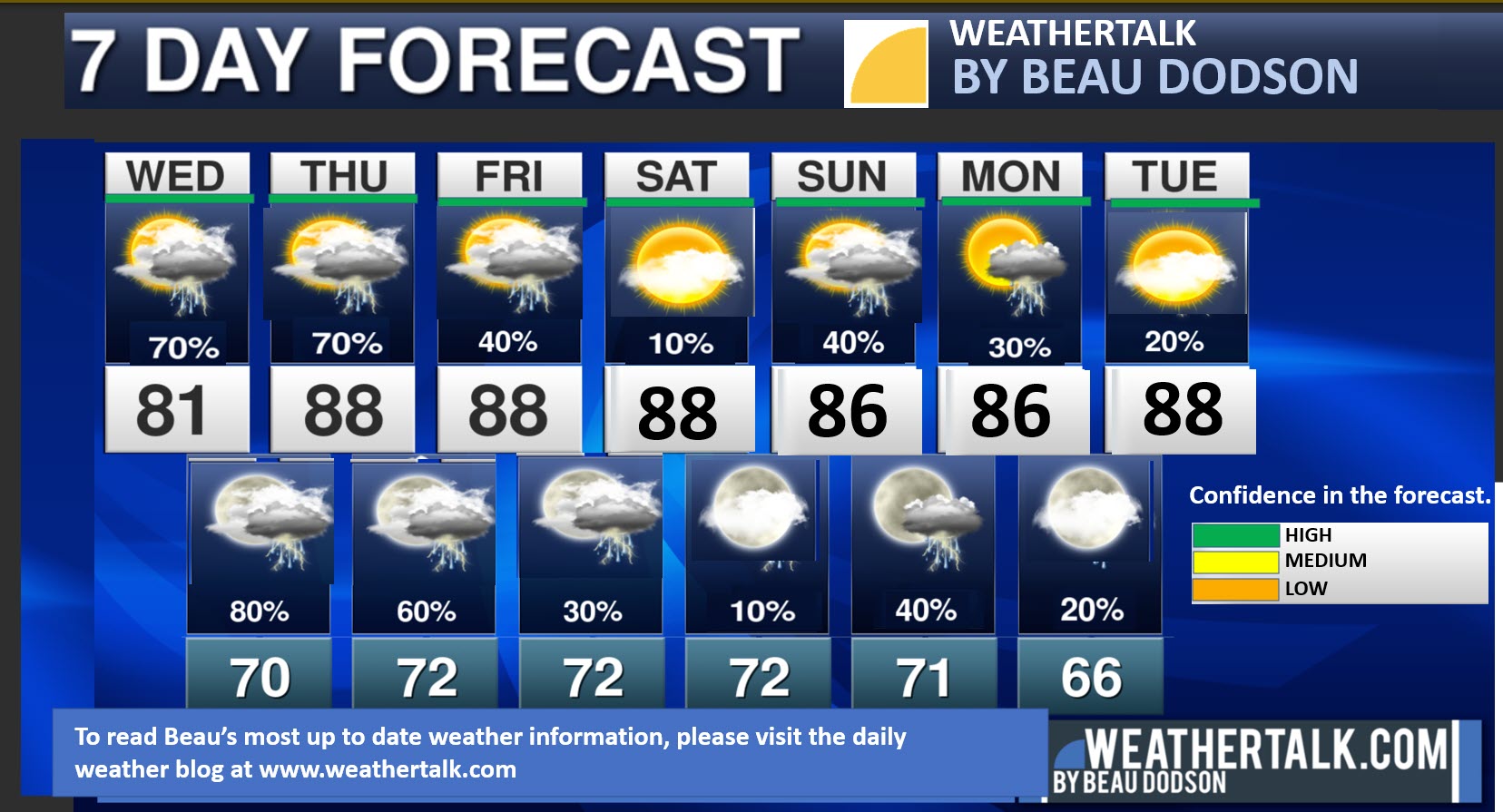
Seven-day forecast for southeast Missouri, southern Illinois, western Kentucky, and western Tennessee.
This is a BLEND for the region. Scroll down to see the region by region forecast.
THE FORECAST IS GOING TO VARY FROM LOCATION TO LOCATION. Scroll down to see the region by region forecast.
Note:
** A difficult forecast. There will be periods of extremely heavy rain for some counties. Flash flooding likely. Monitor updates and your Beau Dodson Weather App over the coming week. Rain totals will vary greatly**
Statement from the National Weather Service
Flood Watch
National Weather Service Paducah KY
140 AM CDT Wed Aug 2 2023

Multiple rounds of thunderstorms producing heavy rain may lead to
flash flooding across portions of southeast Missouri, southern
Illinois, and western Kentucky.

Jefferson-Wayne IL-Perry IL-Franklin-Hamilton-White-Jackson-
Williamson-Saline-Gallatin-Union-Johnson-Pope-Hardin-Alexander-
Pulaski-Massac-Posey-Vanderburgh-Fulton-Hickman-Carlisle-Ballard-
McCracken-Graves-Livingston-Marshall-Calloway-Crittenden-Lyon-Trigg-
Caldwell-Union KY-Webster-Hopkins-Christian-Henderson-Daviess-McLean-
Muhlenberg-Todd-Perry MO-Bollinger-Cape Girardeau-Scott-Mississippi-
Including the cities of Evansville, Bardwell, Greenville, Jackson,
Golconda, Pinckneyville, Poseyville, Hopkinsville, Henderson,
Murphysboro, Dixon, Cairo, Herrin, Elizabethtown, Cadiz, Mayfield,
Benton, Madisonville, McLeansboro, Owensboro, Murray, Fairfield,
Morganfield, Mound City, Cape Girardeau, Vienna, Mount Vernon,
Paducah, Princeton, Shawneetown, Charleston, Marble Hill, Hickman,
Smithland, Calhoun, West Frankfort, Marion, Metropolis, Eddyville,
Harrisburg, Jonesboro, Clinton, Wickliffe, Elkton, Perryville,
Carbondale, Sikeston, and Carmi
140 AM CDT Wed Aug 2 2023

...FLOOD WATCH IN EFFECT FROM THIS EVENING THROUGH THURSDAY
AFTERNOON...

* WHAT...Flooding caused by excessive rainfall is possible.

* WHERE...Portions of southern Illinois, southwest Indiana, western
  Kentucky and southeast Missouri, including the following areas, in
  southern Illinois, Alexander, Franklin, Gallatin, Hamilton,
  Hardin, Jackson, Jefferson, Johnson, Massac, Perry IL, Pope,
  Pulaski, Saline, Union, Wayne IL, White and Williamson. In
  southwest Indiana, Posey and Vanderburgh. In western Kentucky,
  Ballard, Caldwell, Calloway, Carlisle, Christian, Crittenden,
  Daviess, Fulton, Graves, Henderson, Hickman, Hopkins, Livingston,
  Lyon, Marshall, McCracken, McLean, Muhlenberg, Todd, Trigg, Union
  KY and Webster. In southeast Missouri, Bollinger, Cape Girardeau,
  Mississippi, Perry MO and Scott.

* WHEN...From Wednesday evening through Thursday afternoon.

* IMPACTS...Excessive runoff may result in flooding of rivers,
  creeks, streams, and other low-lying and flood-prone locations.

* ADDITIONAL DETAILS...
  - Repeated rounds of thunderstorms may lead to areas of 5 to 7
    inches of rain. This would lead to flash flooding in areas
    seeing the heaviest rainfall.
  - http://www.weather.gov/safety/flood

PRECAUTIONARY/PREPAREDNESS ACTIONS...

You should monitor later forecasts and be alert for possible Flood
Warnings. Those living in areas prone to flooding should be prepared
to take action should flooding develop.
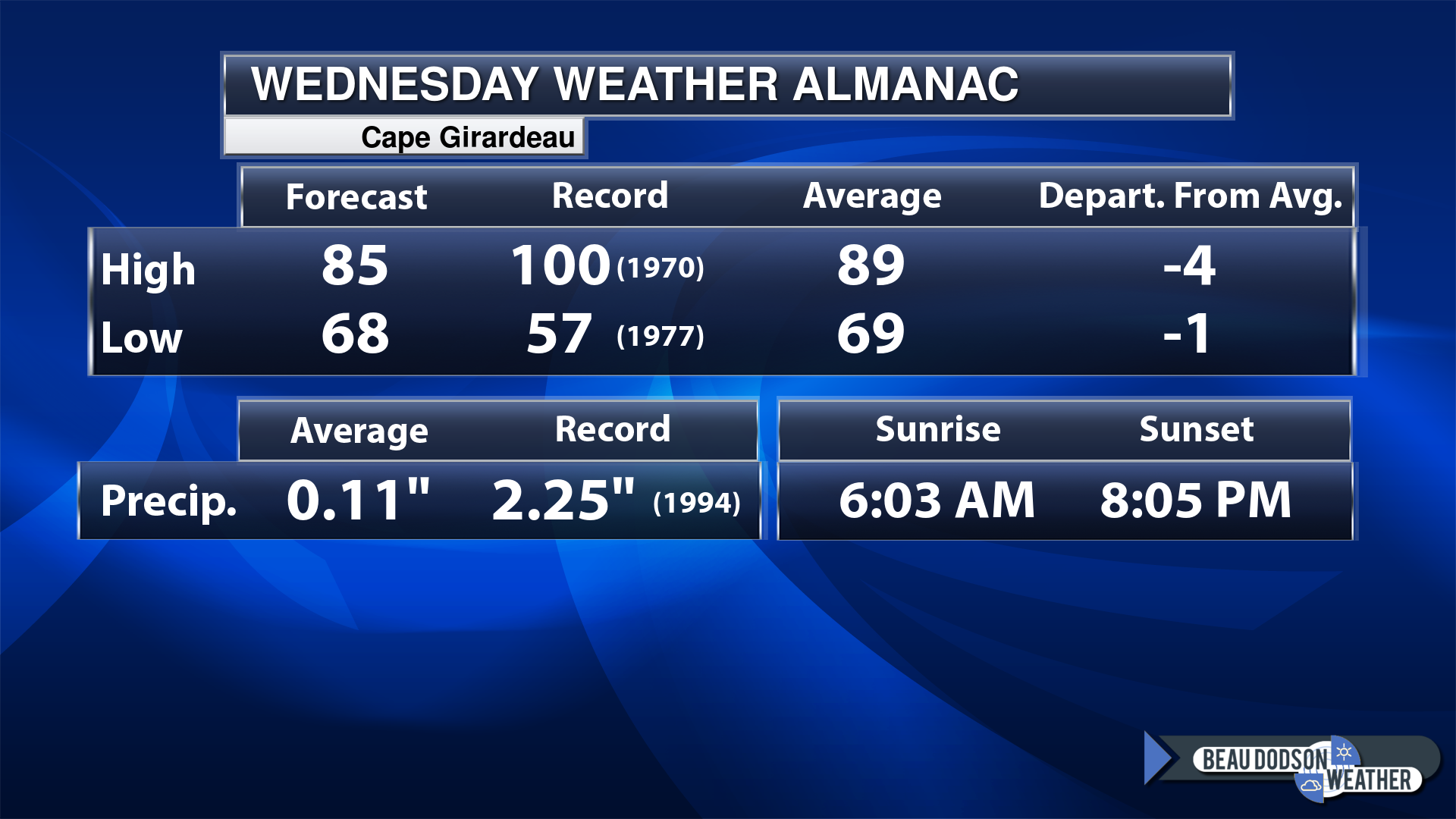
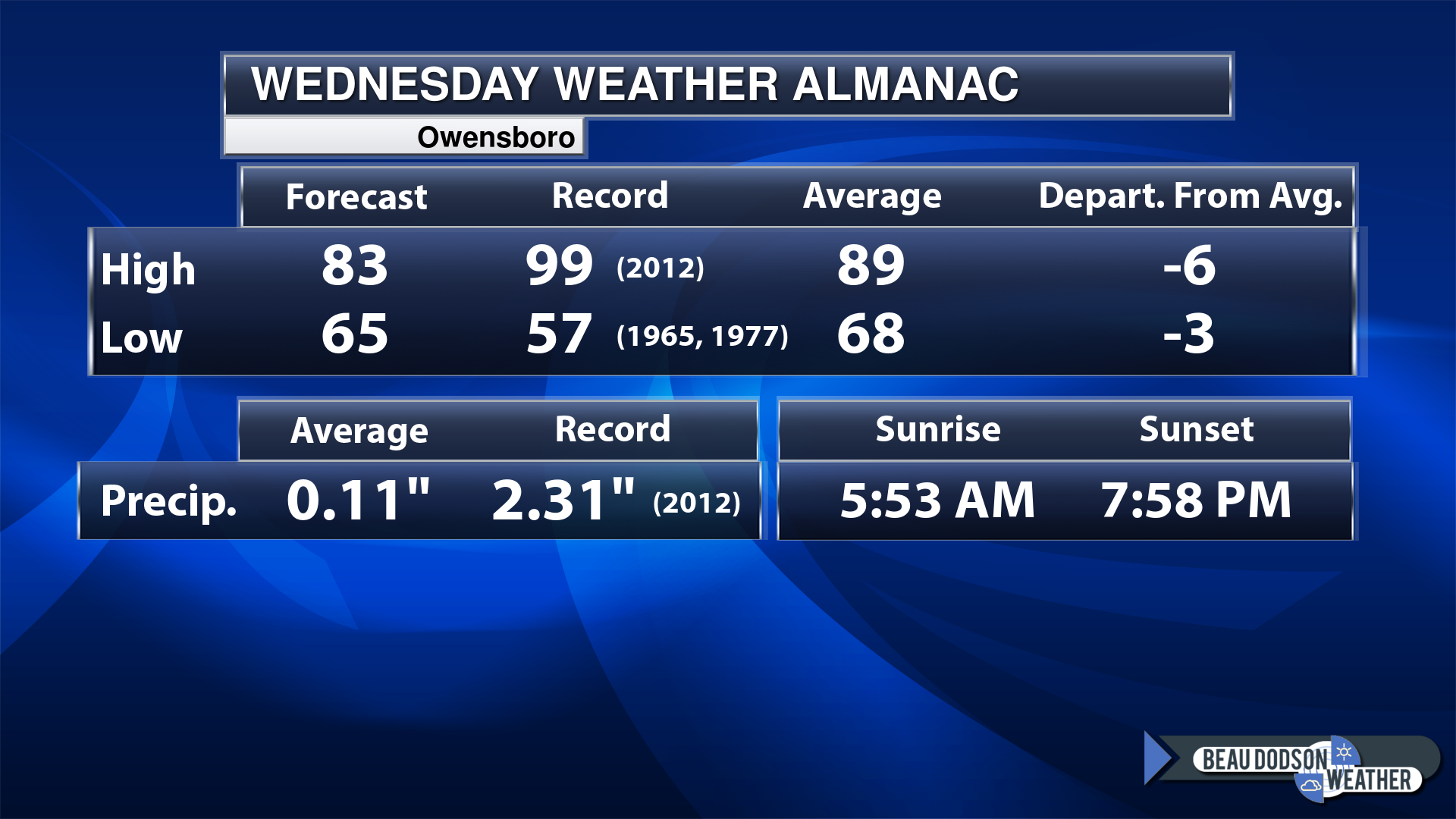
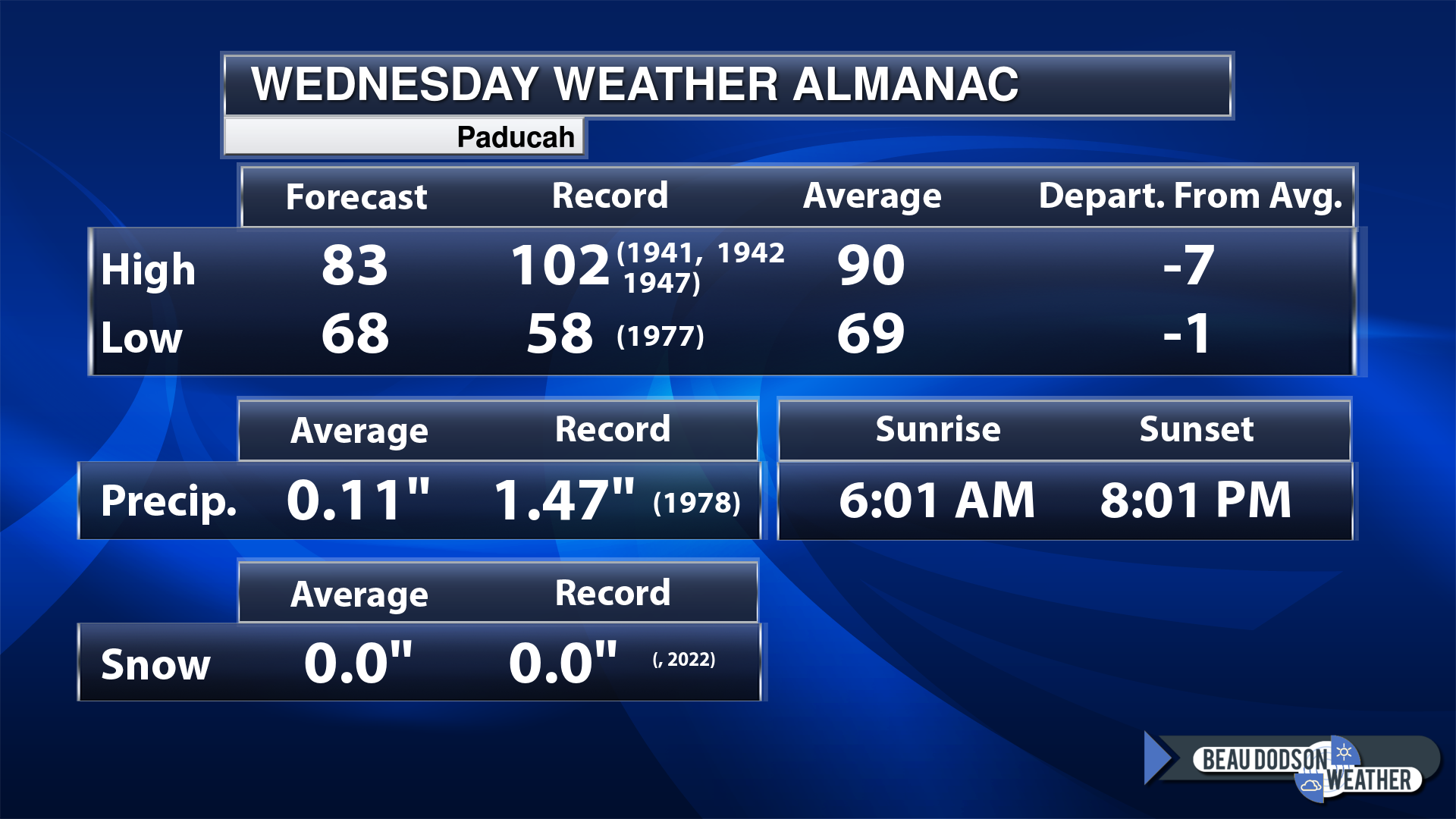
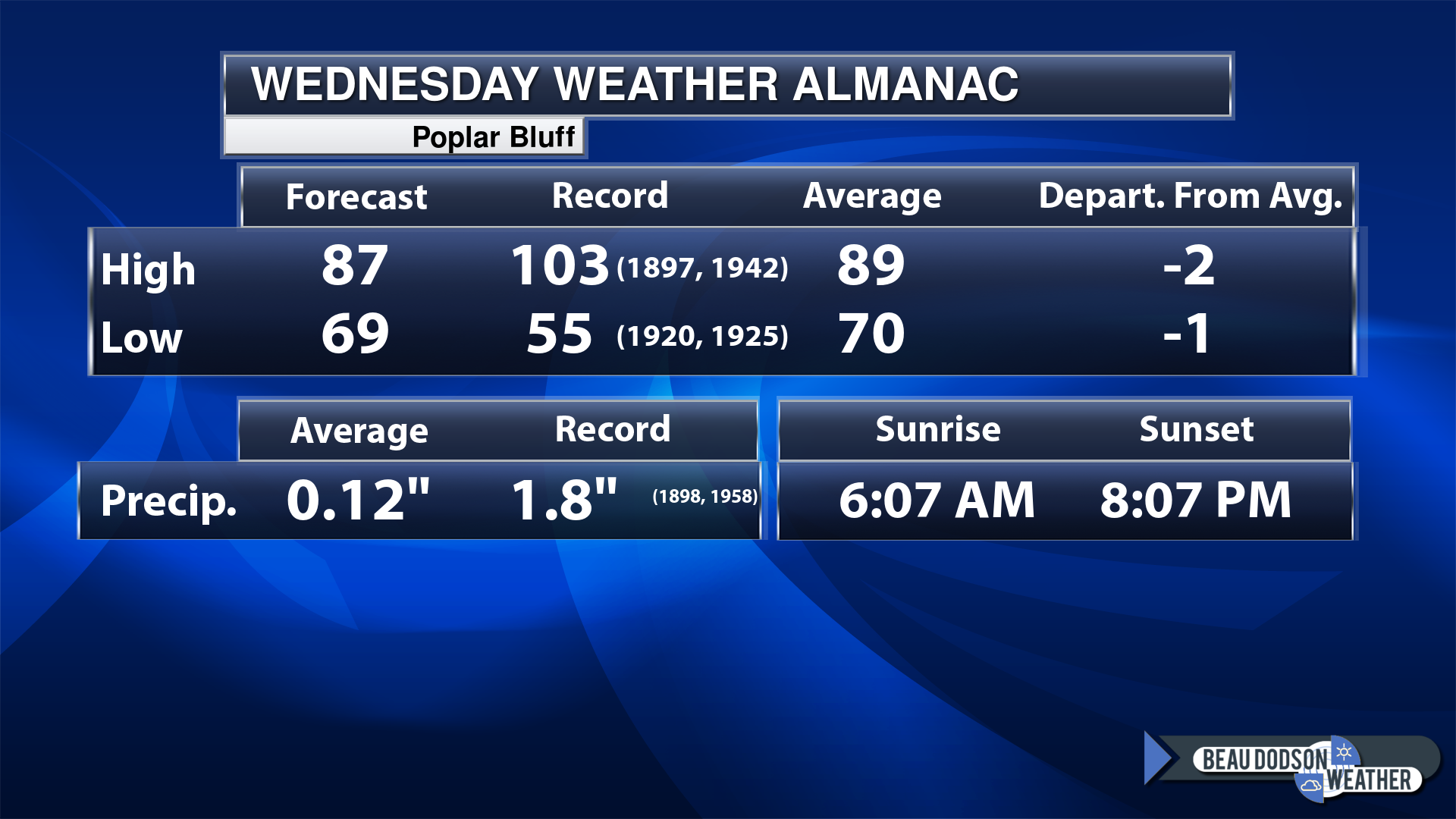
Today’s Local Almanacs (for a few select cities). Your location will be comparable.
Note, the low is this morning’s low and not tomorrows.
Today’s almanac numbers from a few select local cities.
The forecast temperature shows you today’s expected high and this morning’s low.
The graphic shows you the record high and record low for today. It shows you what year that occurred, as well.
It then shows you what today’s average temperature is.
Then, it shows you the departures (how may degrees above or below average temperatures will be ).
It shows you the average precipitation for today. Average comes from thirty years of rain totals.
It also shows you the record rainfall for the date and what year that occurred.
The sunrise and sunset are also shown.
If you have not subscribed to my YouTube Channel then click on this link and it will take you to my videos.
Click the button below and it will take you to the Beau Dodson YouTube Channel.
48-hour forecast


.

.
Wednesday to Wednesday
1. Is lightning in the forecast? Yes. Lightning is possible today into the weekend. Stay weather aware.
2. Are severe thunderstorms in the forecast? Yes. Storms over the coming days could produce gusty wind and hail. Scattered severe weather can’t be ruled out.
3. Is flash flooding in the forecast? Yes. Flash flooding is likely this week. Some counties could receive more than six inches of rain. Monitor updates throughout the week as the forecast becomes more in focus. I will be sending out Beau Dodson Weather App messages.
4. Will the heat index exceed 100 degrees? Monitor.
5. Will the wind chill dip below 10 degrees? No.
6. Is measurable snow and/or sleet in the forecast? No.
7. Is freezing rain/ice in the forecast? No.
Freezing rain is rain that falls and instantly freezes on objects such as trees and power lines
.
.
Wednesday, August 2, 2023
Confidence in the forecast? High Confidence
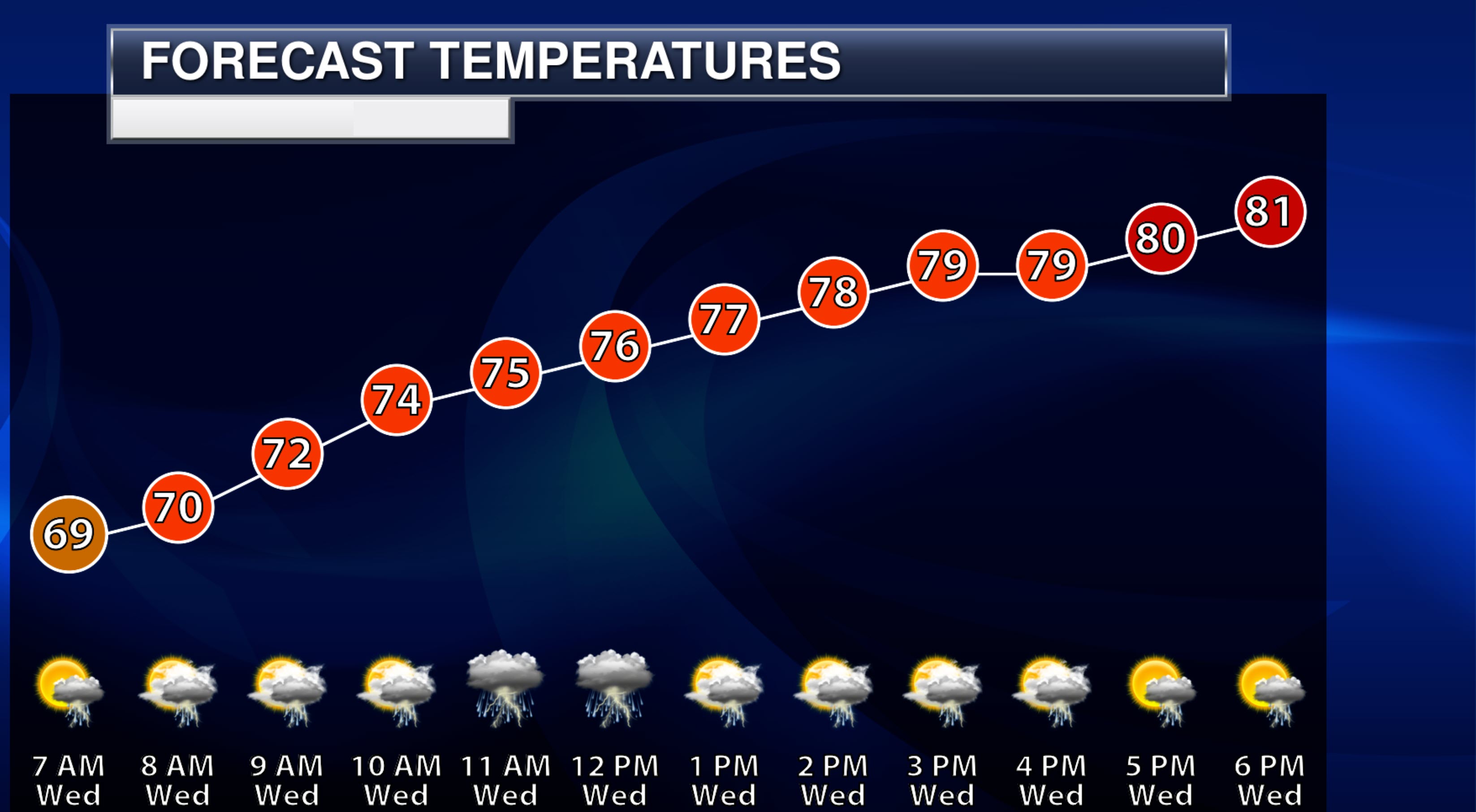
Wednesday Forecast: Mostly cloudy. A chance of showers and thunderstorms. Coverage will be highest before noon. Locally heavy rain.
What is the chance of precipitation?
Far northern southeast Missouri ~ 100%
Southeast Missouri ~ 70%
The Missouri Bootheel ~ 60%
I-64 Corridor of southern Illinois ~ 100%
Southern Illinois ~ 80%
Extreme southern Illinois (southern seven counties) ~ 80%
Far western Kentucky ~ 70%
The Pennyrile area of western KY ~ 40%
Northwest Kentucky (near Indiana border) ~ 60%
Northwest Tennessee ~ 60%
Coverage of precipitation: Numerous.
Timing of the precipitation: Any given point of time.
Far northern southeast Missouri ~ 78° to 82°
Southeast Missouri ~ 82° to 85°
The Missouri Bootheel ~ 86° to 88°
I-64 Corridor of southern Illinois ~ 78° to 82°
Southern Illinois ~ 82° to 85°
Extreme southern Illinois (southern seven counties) ~ 83° to 86°
Far western Kentucky ~ 83° to 86°
The Pennyrile area of western KY ~ 83° to 86°
Northwest Kentucky (near Indiana border) ~ 83° to 86°
Northwest Tennessee ~ 84° to 86°
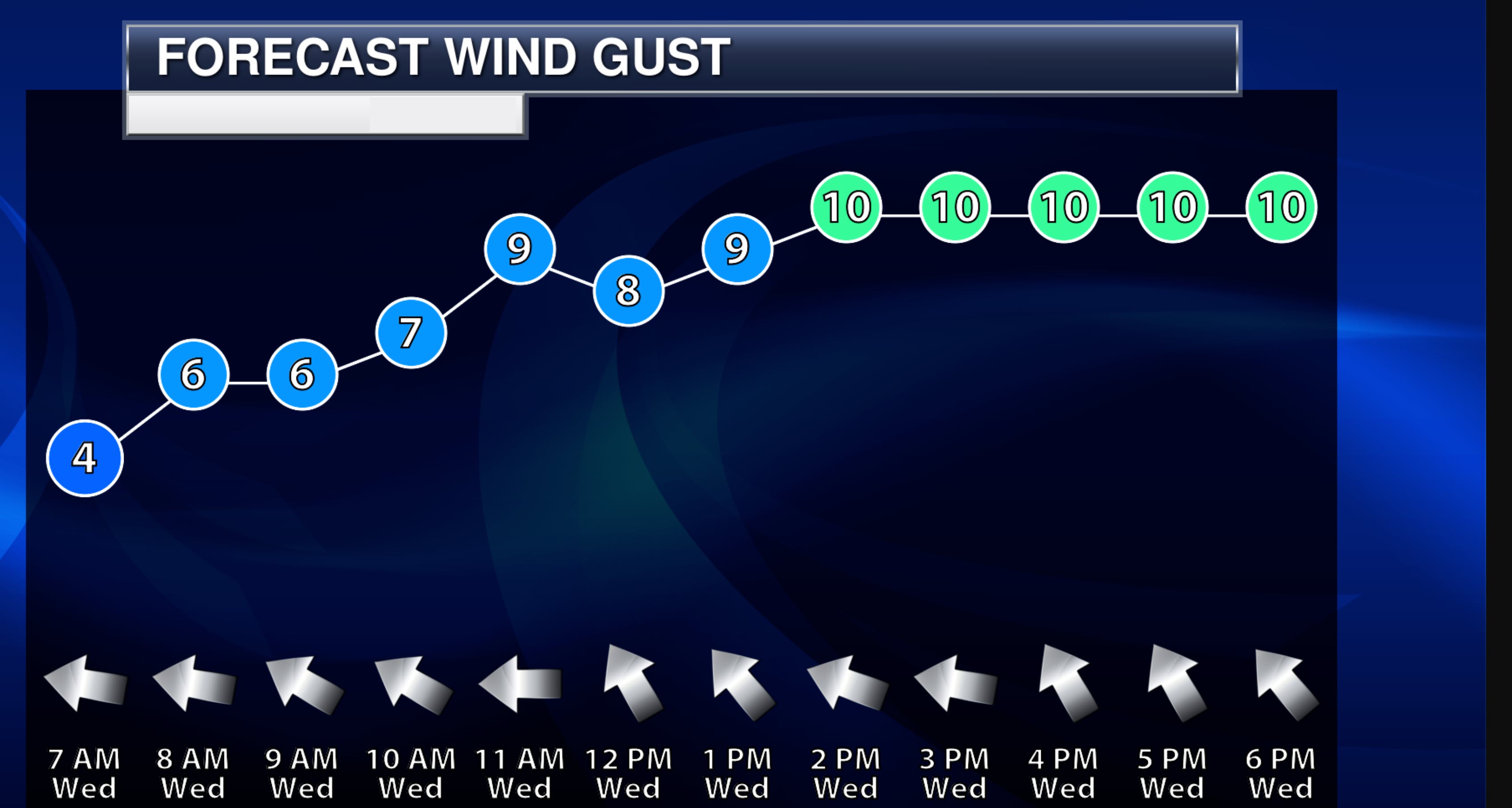
Winds will be from this direction: Southeast 7 to 14 mph
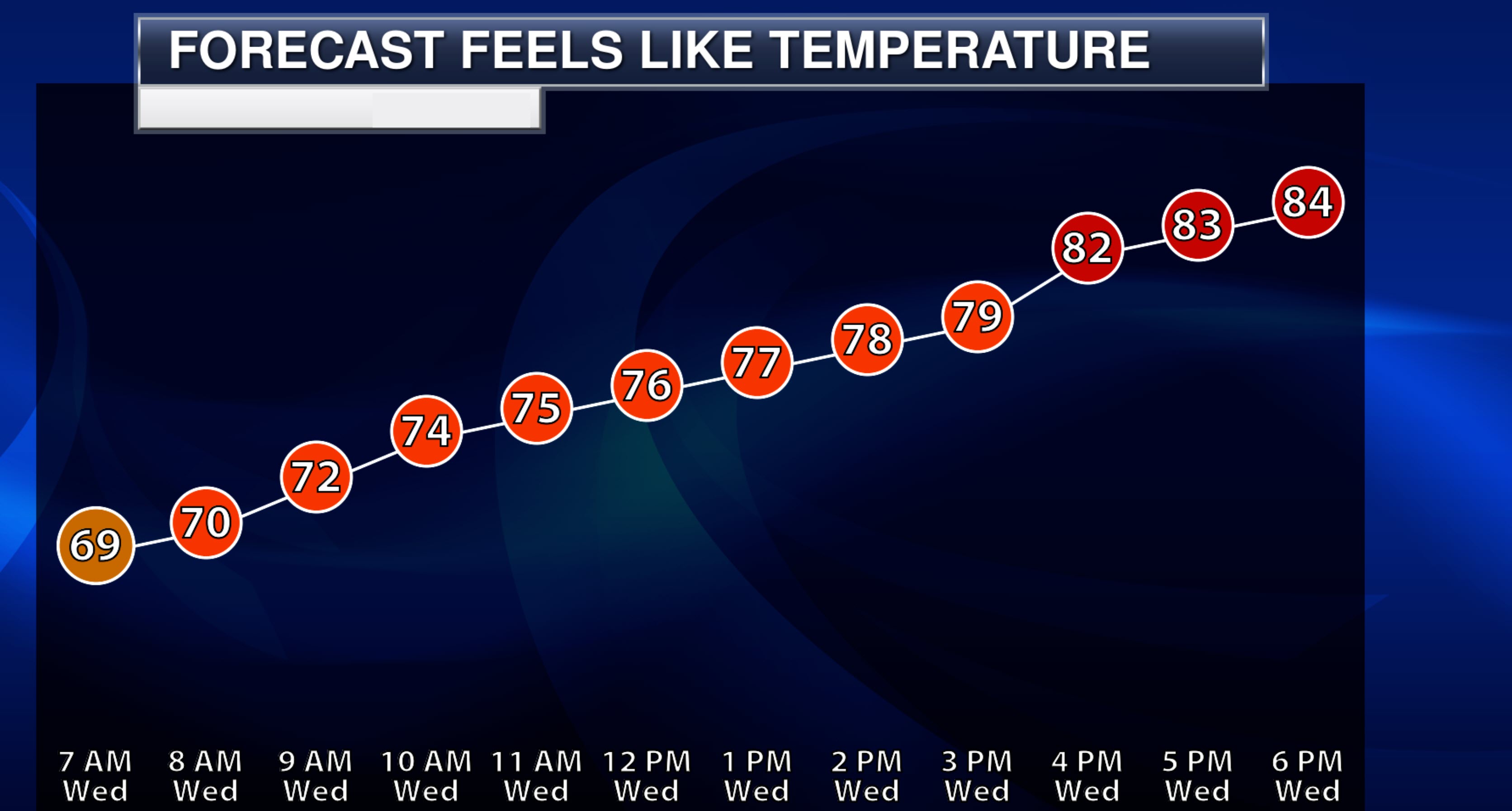
Wind chill or heat index (feels like) temperature forecast: 83° to 86°
What impacts are anticipated from the weather? Wet roadways. Lightning. Heavy rain. Gusty wind near storms. Flash flood potential.
Should I cancel my outdoor plans? No, but monitor updates and the Beau Dodson Weather Radars
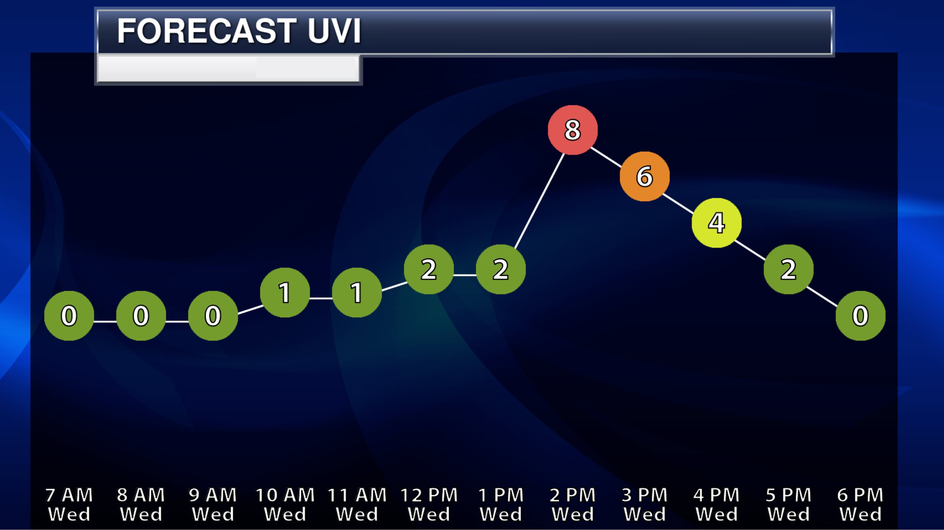
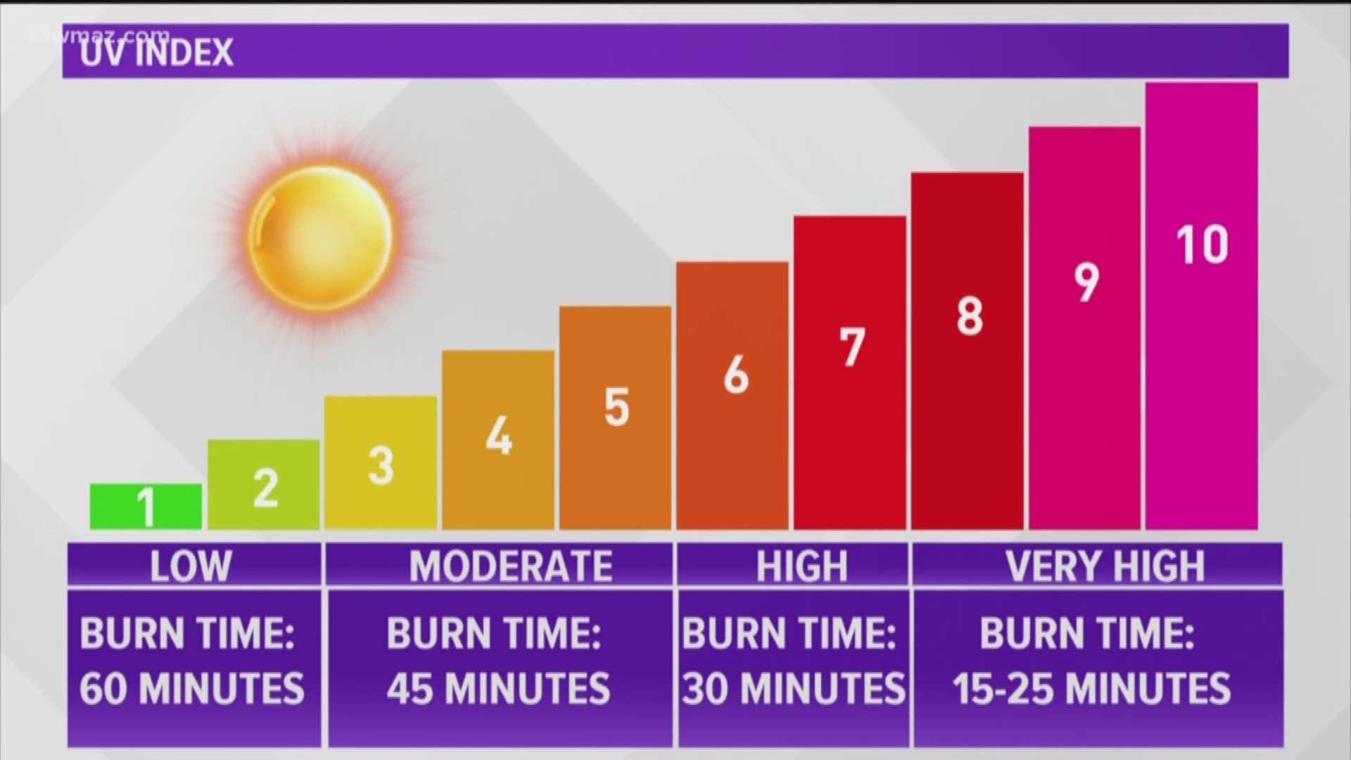
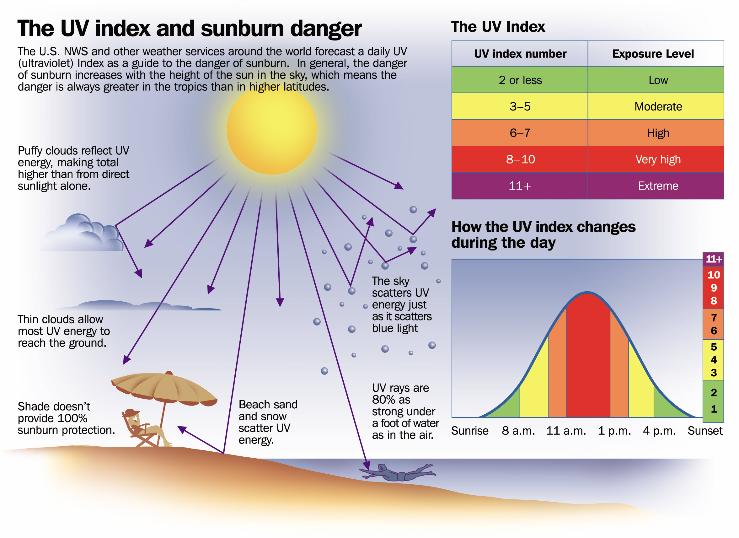
UV Index: 7. High
Sunrise: 6:01 AM
Sunset: 8:02 PM
.
Wednesday night Forecast: Mostly cloudy. A chance of showers and thunderstorms. Especially late at night. Locally heavy rain.
What is the chance of precipitation?
Far northern southeast Missouri ~ 80%
Southeast Missouri ~ 70%
The Missouri Bootheel ~ 30%
I-64 Corridor of southern Illinois ~ 90%
Southern Illinois ~ 90%
Extreme southern Illinois (southern seven counties) ~ 80%
Far western Kentucky ~ 70%
The Pennyrile area of western KY ~ 70%
Northwest Kentucky (near Indiana border) ~ 80%
Northwest Tennessee ~ 40%
Coverage of precipitation: Numerous
Timing of the precipitation: Any given point of time
Temperature range:
Far northern southeast Missouri ~ 68° to 72°
Southeast Missouri ~ 70° to 74°
The Missouri Bootheel ~ 70° to 74°
I-64 Corridor of southern Illinois ~ 68° to 72°
Southern Illinois ~ 70° to 74°
Extreme southern Illinois (southern seven counties) ~ 70° to 74°
Far western Kentucky ~ 70° to 74°
The Pennyrile area of western KY ~ 70° to 74°
Northwest Kentucky (near Indiana border) ~ 70° to 74°
Northwest Tennessee ~ 70° to 74°
Winds will be from this direction: East southeast 7 to 14 mph
Wind chill or heat index (feels like) temperature forecast: 70° to 74°
What impacts are anticipated from the weather? Wet roadways. Lightning. Heavy rain. Gusty wind near storms. Flash flood potential.
Should I cancel my outdoor plans? No, but monitor updates and the Beau Dodson Weather Radars
Moonrise: 9:12 PM
Moonset: 6:47 AM
The phase of the moon: Waning Gibbous
.
Thursday, August 3, 2023
Confidence in the forecast? High Confidence
Thursday Forecast: Partly sunny. A chance of showers and thunderstorms. Locally heavy rain. High temperatures will be dependent on cloud cover and rain.
What is the chance of precipitation?
Far northern southeast Missouri ~ 60%
Southeast Missouri ~ 40%
The Missouri Bootheel ~ 30%
I-64 Corridor of southern Illinois ~ 80%
Southern Illinois ~ 80%
Extreme southern Illinois (southern seven counties) ~ 80%
Far western Kentucky ~ 70%
The Pennyrile area of western KY ~ 70%
Northwest Kentucky (near Indiana border) ~ 70%
Northwest Tennessee ~ 40%
Coverage of precipitation: Scattered to numerous
Timing of the precipitation: Any given point of time.
Far northern southeast Missouri ~ 88° to 90°
Southeast Missouri ~ 88° to 90°
The Missouri Bootheel ~ 90° to 94°
I-64 Corridor of southern Illinois ~ 84° to 88°
Southern Illinois ~ 84° to 88°
Extreme southern Illinois (southern seven counties) ~ 84° to 88°
Far western Kentucky ~ 88° to 90°
The Pennyrile area of western KY ~ 88° to 90°
Northwest Kentucky (near Indiana border) ~ 88° to 90°
Northwest Tennessee ~ 88° to 90°
Winds will be from this direction: South southeast 8 to 16 mph
Wind chill or heat index (feels like) temperature forecast: 82° to 105° The high numbers will be over portions of southeast Missouri where the clouds and precip don’t impact, as well.
What impacts are anticipated from the weather? Wet roadways. Lightning. Heavy rain. Gusty wind near storms. Flash flood potential.
Should I cancel my outdoor plans? No, but monitor updates and the Beau Dodson Weather Radars
UV Index: 9. Very high
Sunrise: 6:01 AM
Sunset: 8:01 PM
.
Thursday night Forecast: Partly cloudy. A chance of showers and thunderstorms.
What is the chance of precipitation?
Far northern southeast Missouri ~ 30%
Southeast Missouri ~ 30%
The Missouri Bootheel ~ 20%
I-64 Corridor of southern Illinois ~ 40%
Southern Illinois ~ 40%
Extreme southern Illinois (southern seven counties) ~ 30%
Far western Kentucky ~ 30%
The Pennyrile area of western KY ~ 40%
Northwest Kentucky (near Indiana border) ~ 40%
Northwest Tennessee ~ 20%
Coverage of precipitation: Scattered
Timing of the precipitation: Any given point of time
Temperature range:
Far northern southeast Missouri ~ 70° to 74°
Southeast Missouri ~ 70° to 74°
The Missouri Bootheel ~ 70° to 74°
I-64 Corridor of southern Illinois ~ 70° to 74°
Southern Illinois ~ 70° to 74°
Extreme southern Illinois (southern seven counties) ~ 70° to 74°
Far western Kentucky ~ 70° to 74°
The Pennyrile area of western KY ~ 70° to 74°
Northwest Kentucky (near Indiana border) ~ 70° to 74°
Northwest Tennessee ~ 70° to 74°
Winds will be from this direction: North northwest 6 to 12 mph
Wind chill or heat index (feels like) temperature forecast: 70° to 74°
What impacts are anticipated from the weather? Wet roadways. Lightning. Heavy rain. Gusty wind near storms.
Should I cancel my outdoor plans? No, but monitor updates and the Beau Dodson Weather Radars
Moonrise: 9:44 PM
Moonset: 8:05 AM
The phase of the moon: Waning Gibbous
.
Friday, August 4, 2023
Confidence in the forecast? High Confidence
Friday Forecast: Partly sunny. A chance of showers and thunderstorms.
What is the chance of precipitation?
Far northern southeast Missouri ~ 30%
Southeast Missouri ~ 30%
The Missouri Bootheel ~ 30%
I-64 Corridor of southern Illinois ~ 30%
Southern Illinois ~ 30%
Extreme southern Illinois (southern seven counties) ~ 30%
Far western Kentucky ~ 40%
The Pennyrile area of western KY ~ 40%
Northwest Kentucky (near Indiana border) ~ 40%
Northwest Tennessee ~ 30%
Coverage of precipitation: Scattered to numerous
Timing of the precipitation: Any given point of time.
Far northern southeast Missouri ~ 85° to 90°
Southeast Missouri ~ 85° to 90°
The Missouri Bootheel ~ 85° to 90°
I-64 Corridor of southern Illinois ~ 85° to 90°
Southern Illinois ~ 85° to 90°
Extreme southern Illinois (southern seven counties) ~ 85° to 90°
Far western Kentucky ~ 85° to 90°
The Pennyrile area of western KY ~ 85° to 90°
Northwest Kentucky (near Indiana border) ~ 85° to 90°
Northwest Tennessee ~ 85° to 90°
Winds will be from this direction: North northwest 7 to 14 mph
Wind chill or heat index (feels like) temperature forecast: 86° to 92°
What impacts are anticipated from the weather? Wet roadways. Lightning.
Should I cancel my outdoor plans? No, but monitor updates and the Beau Dodson Weather Radars
UV Index: 8. Very high
Sunrise: 6:02 AM
Sunset: 8:00 PM
.
Friday night Forecast: Partly cloudy. A chance of showers and thunderstorms.
What is the chance of precipitation?
Far northern southeast Missouri ~ 30%
Southeast Missouri ~ 30%
The Missouri Bootheel ~ 30%
I-64 Corridor of southern Illinois ~ 30%
Southern Illinois ~ 30%
Extreme southern Illinois (southern seven counties) ~ 30%
Far western Kentucky ~ 30%
The Pennyrile area of western KY ~ 30%
Northwest Kentucky (near Indiana border) ~ 30%
Northwest Tennessee ~ 30%
Coverage of precipitation: Widely scattered
Timing of the precipitation: Any given point of time
Temperature range:
Far northern southeast Missouri ~ 68° to 72°
Southeast Missouri ~ 68° to 72°
The Missouri Bootheel ~ 68° to 72°
I-64 Corridor of southern Illinois ~ 68° to 72°
Southern Illinois ~ 68° to 72°
Extreme southern Illinois (southern seven counties) ~ 68° to 72°
Far western Kentucky ~ 68° to 72°
The Pennyrile area of western KY ~ 68° to 72°
Northwest Kentucky (near Indiana border) ~ 68° to 72°
Northwest Tennessee ~ 68° to 72°
Winds will be from this direction: East 7 to 14 mph
Wind chill or heat index (feels like) temperature forecast: 68° to 72°
What impacts are anticipated from the weather? Wet roadways. Lightning.
Should I cancel my outdoor plans? No, but monitor updates and the Beau Dodson Weather Radars
Moonrise: 10:12 PM
Moonset: 9:20 AM
The phase of the moon: Waning Gibbous
Click here if you would like to return to the top of the page.
-
- Showers and thunderstorms
- Flash flooding is a concern for some counties.
- Severe weather potential.
Weather advice:
Make sure you have three to five ways of receiving your severe weather information.
Avoid flooded roadways.
.
Forecast Discussion
Today’s Average Regional Forecast Numbers
Temperatures will vary based on cloud cover and precipitation. Keep that in mind.
Flash flood threat.
Good day, everyone
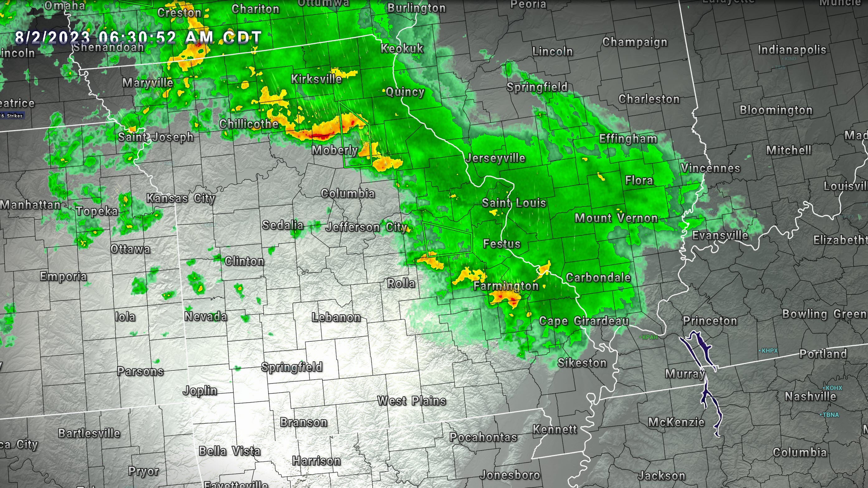
As of 6 AM, widespread showers and thunderstorms are moving into the region from the northwest.
These showers and storms are occasionally producing gusty wind and heavy rain.
Three to six inches of rain (locally higher) fell overnight across portions of eastern Missouri. About where we thought it would fall. West of St Louis.
A stripe of very heavy totals was noted on radar.
Flash flooding is ongoing in those areas.
With time, this will all weaken and even dissipate. That is how these MCS’s usually work. They peak late at night into the morning hours as the low level jet ramps up and then weakens.
The 6 AM radar showed the rain.
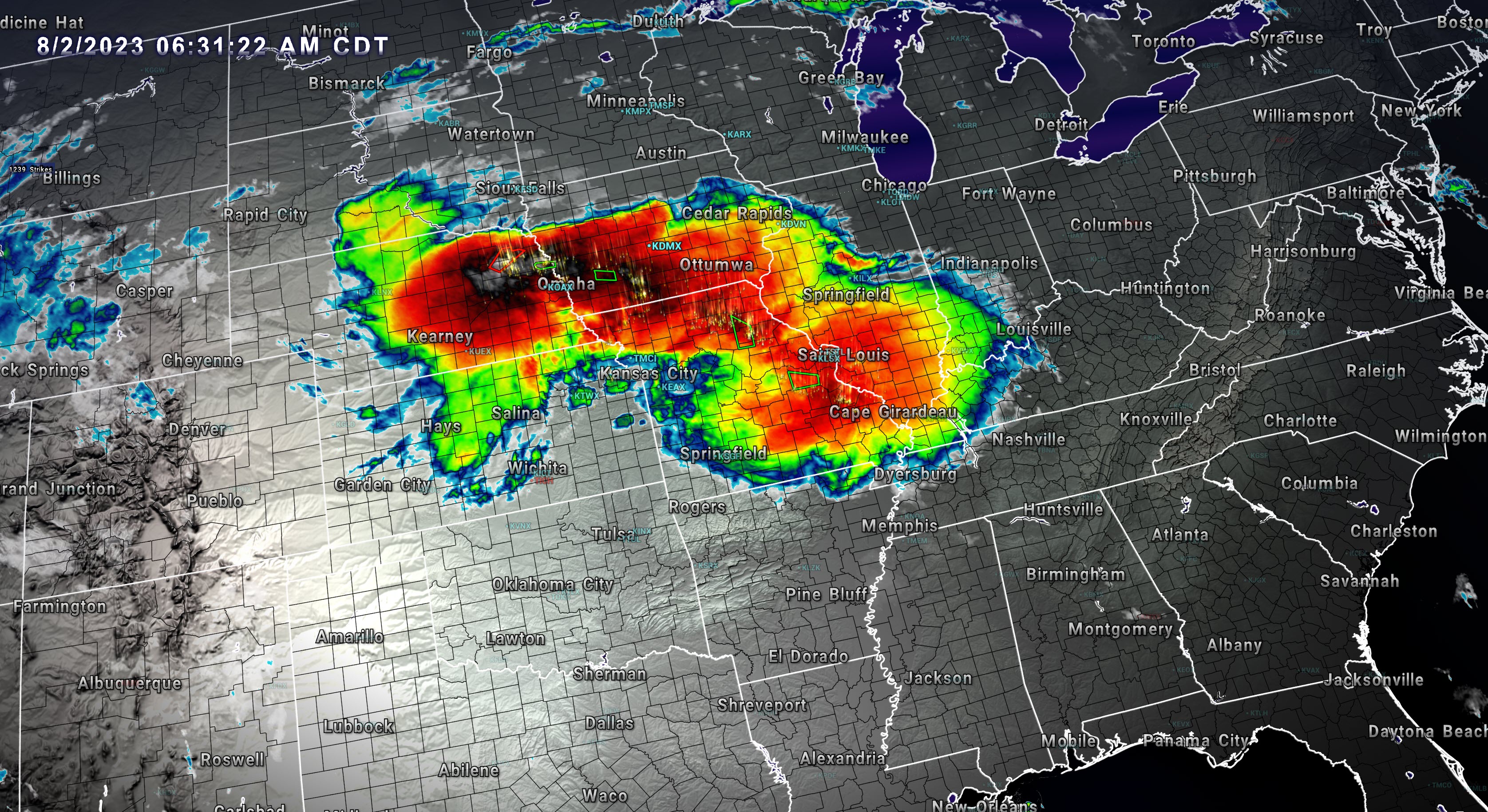
IR satellite shows multiple MCS’s. Thunderstorm complexes.
The bright red colors are very cold cloud tops. Thunderstorms towering to 60,000′.
We have multiple weather concerns over the coming days.
First, we have a risk of severe thunderstorms later this evening into tonight. The primary concern will be damaging wind and hail. Frequent lightning, as well. Locally heavy rain.
The SPC has us in a risk of severe weather. A level one and two risk. We will see if there are any adjustments to this as we move through the day.

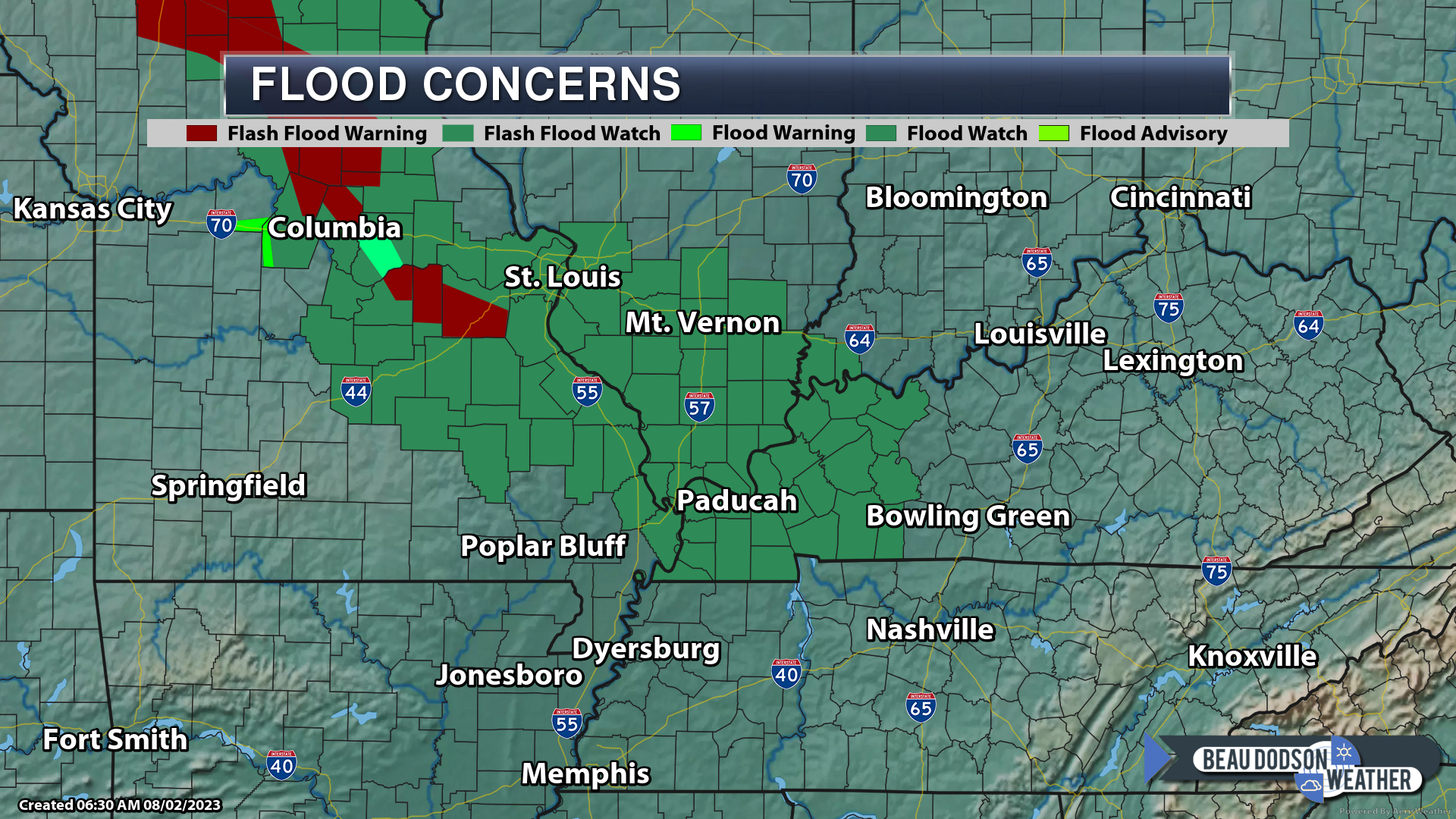
A flash flood watch has been issued for the region into Thursday.
The dark green is the flash flood watch
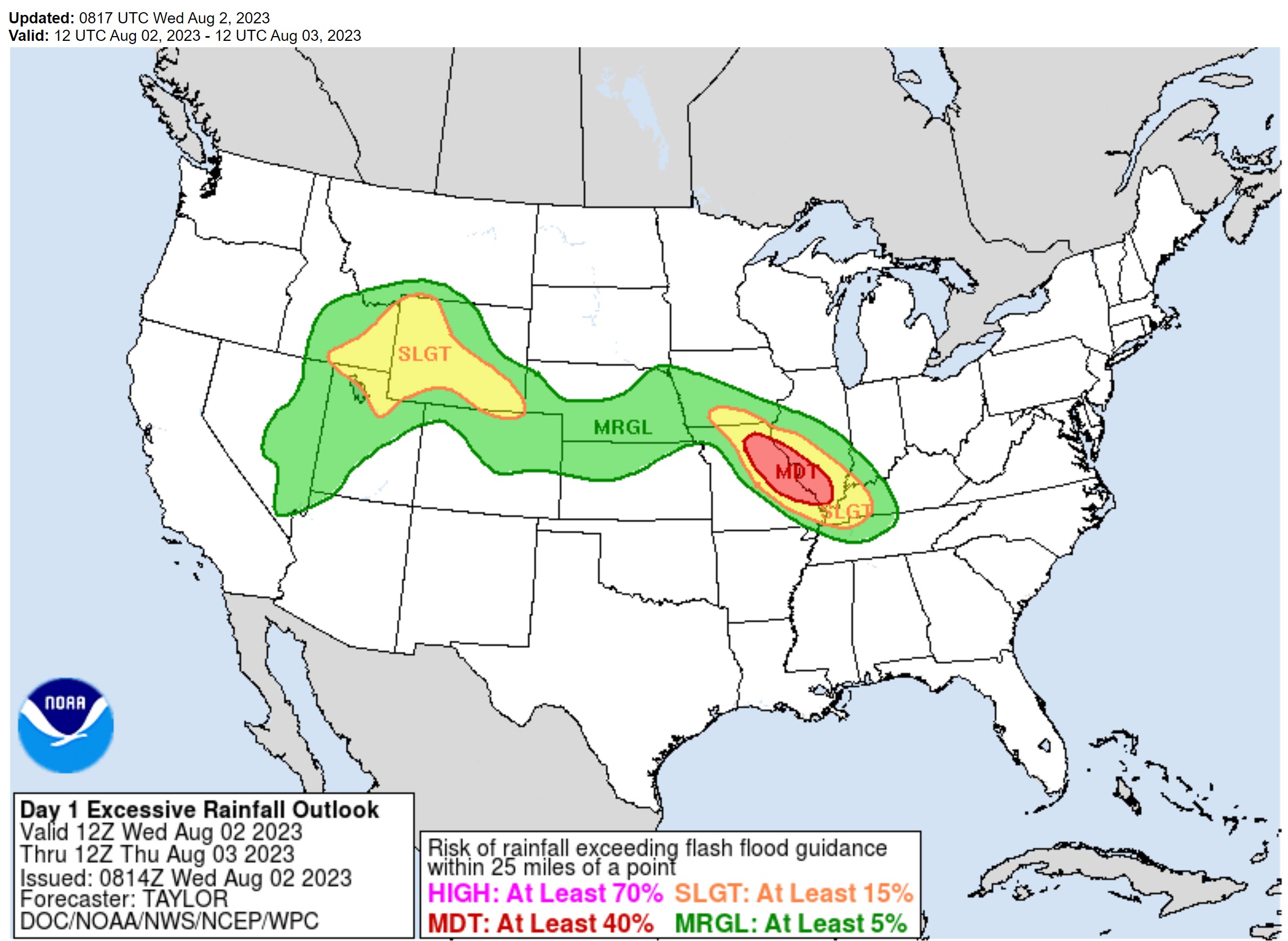
Then, the WPC has us in a slight and moderate risk of flash flooding today into tomorrow morning.
The primary time-frame of concern will be tonight and tomorrow morning.
Rain totals will exceed 5 inches in some counties. But where? That is the big question.
Guidance is not in agreement on where the heaviest band tracks.
During the last event, the models were too far east northeast.
The red zone is the current best forecast for where the heaviest rain will occur. It is possible there are additional adjustments.
Either way, avoid flooded roadways. This will save lives. Every year people drive into flood waters and perish.
We do not believe this will be as extensive as the flash flood event two weeks ago. With that said, it does not take historic flooding to be dangerous.
Someone will have a lot of rain from this event. I would not be surprised to see several flash flood warnings tonight into tomorrow morning.
Here are the WPC comments. Technical discussion for you weather nerds!
Excessive Rainfall Discussion
NWS Weather Prediction Center College Park MD
418 AM EDT Wed Aug 02 2023

Day 1
Valid 12Z Wed Aug 02 2023 - 12Z Thu Aug 03 2023

THERE IS A MODERATE RISK OF EXCESSIVE RAINFALL ACROSS PORTIONS
OF THE MID MISSISSIPPI VALLEY...

...Mid Mississippi to Lower Ohio Valleys...
A significant flash flooding event is expected across portions of
Mid Mississippi Valley this morning and then again late tonight
into Thursday morning, impacting much of north-central to
east-central Missouri with a narrow but potentially extreme amount
of rainfall in short period of time. This includes the greater St.
Louis metro area, particularly for tonight/early Thursday morning.

Early this morning, convection has continued to blossom and expand
in coverage from southern Iowa through central Missouri at the
nose of the strengthening low level jet. The latest RAP analysis
showed upwards of 40 kts overrunning a frontal boundary draped
across the region. This coincides with favorable forcing for
ascent from shortwave energy rounding the periphery of the strong
upper ridge axis. Finally, moisture anomalies are quite high this
morning, where the blended TPW product shows values exceeding 2",
and likely to increase further. The current convection will slowly
drift south/southeast through central/east-central Missouri
through mid to late morning. High warm cloud depths and an axis of
2000-2500 J/kg MUCAPE this morning will support higher end rain
rates exceeding 2-3"/hr (localized 3"+ hourly totals possible) and
with backbuilding/training convection, several hours of these
intense rain rates in a narrow/localized swath is likely to
produce a swath of extreme rainfall totaling 4-8"+ (localized
8-10") through the morning, which is supported by the 00Z HREF
showing 50-60 percent probabilities for 5"+. This activity will
begin to wane after 15Z (most intense rain rates through 15Z) but
may not completely subside until early afternoon.

Then later tonight into Thursday morning, another round of locally
significant heavy rainfall is expected to develop across eastern
Missouri into southern Illinois. Continued anomalous moisture,
another surging low level jet, favorable instability, and high
warm cloud depths all point toward intense rain rates (2-3"/hr)
and localized higher end rain totals. The axis of heaviest rain
may fall just east/southeast of this morning's heavy rainfall
footprint, but very close overlap and also in and around the St.
Louis metro. The 00Z HREF probs for 5"+ again reach 50-60 percent
for tonight/early Thursday morning, maximized just west of St.
Louis which shows even a near 20 percent chance for 8" totals. The
00Z CAMs generally all point to an higher end Moderate Risk flash
flood event event and with the proximity to the STL metro, higher
end flash flooding will be possible due to the intensity of
rainfall for several hours over a more urbanized location.
Again, someone will have a lot of rain from this event. Stay weather aware.
Scattered thunderstorms will continue into Thursday afternoon and likely into Friday night. We aren’t quite sure, however, that it will be as organized as what is happening this morning and tonight.
But, if you have outdoor plans Thursday afternoon into Friday night, then monitor updates and radars.
Saturday will be the day with the lowest rain probabilities.
A cold front will push into the region Sunday and Monday.
At this time, it appears the front will push through the region Sunday and Sunday night. That will bring a renewed round of showers and thunderstorms.
Some of those storms could be severe, but the latest data isn’t quite as strong as it appeared yesterday. I will monitor trends over the coming days.
A few strong storms can’t be ruled out.
A few model packages linger thunderstorms into Monday, but it does appear the system will be pushing out of the region by then. That will also bring some cooler temperatures.
.
Click here if you would like to return to the top of the page.
This outlook covers southeast Missouri, southern Illinois, western Kentucky, and far northwest Tennessee.
Today through April 18th: A couple of the Saturday afternoon and night thunderstorms could produce damaging wind and hail. The tornado risk is low, but not zero. Mainly over Missouri for the tornado risk. The line will weaken with time as it moves farther east.
.
Today’s Storm Prediction Center’s Severe Weather Outlook
Light green is where thunderstorms may occur but should be below severe levels.
Dark green is a level one risk. Yellow is a level two risk. Orange is a level three (enhanced) risk. Red is a level four (moderate) risk. Pink is a level five (high) risk.
One is the lowest risk. Five is the highest risk.
A severe storm is one that produces 58 mph wind or higher, quarter size hail, and/or a tornado.
Explanation of tables. Click here.

.
Tornado Probability Outlook

.
Large Hail Probability Outlook

.
High wind Probability Outlook

.
Tomorrow’s severe weather outlook.

.
Day Three Severe Weather Outlook

.

.
The images below are from NOAA’s Weather Prediction Center.
24-hour precipitation outlook..
 .
.
.
48-hour precipitation outlook.
. .
.
![]()
_______________________________________
.

Click here if you would like to return to the top of the page.
Again, as a reminder, these are models. They are never 100% accurate. Take the general idea from them.
What should I take from these?
- The general idea and not specifics. Models usually do well with the generalities.
- The time-stamp is located in the upper left corner.
.
What am I looking at?
You are looking at computer model data. Meteorologists use many different models to forecast the weather.
Occasionally, these maps are in Zulu time. 12z=7 AM. 18z=1 PM. 00z=7 PM. 06z=1 AM
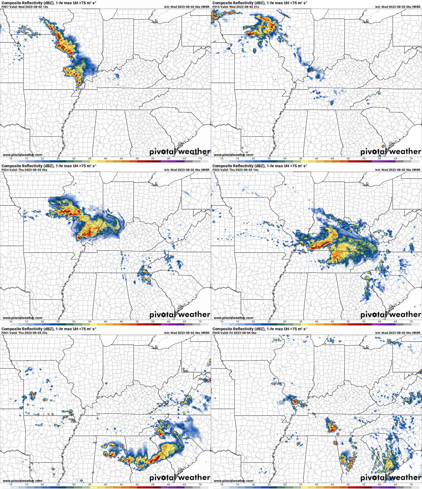
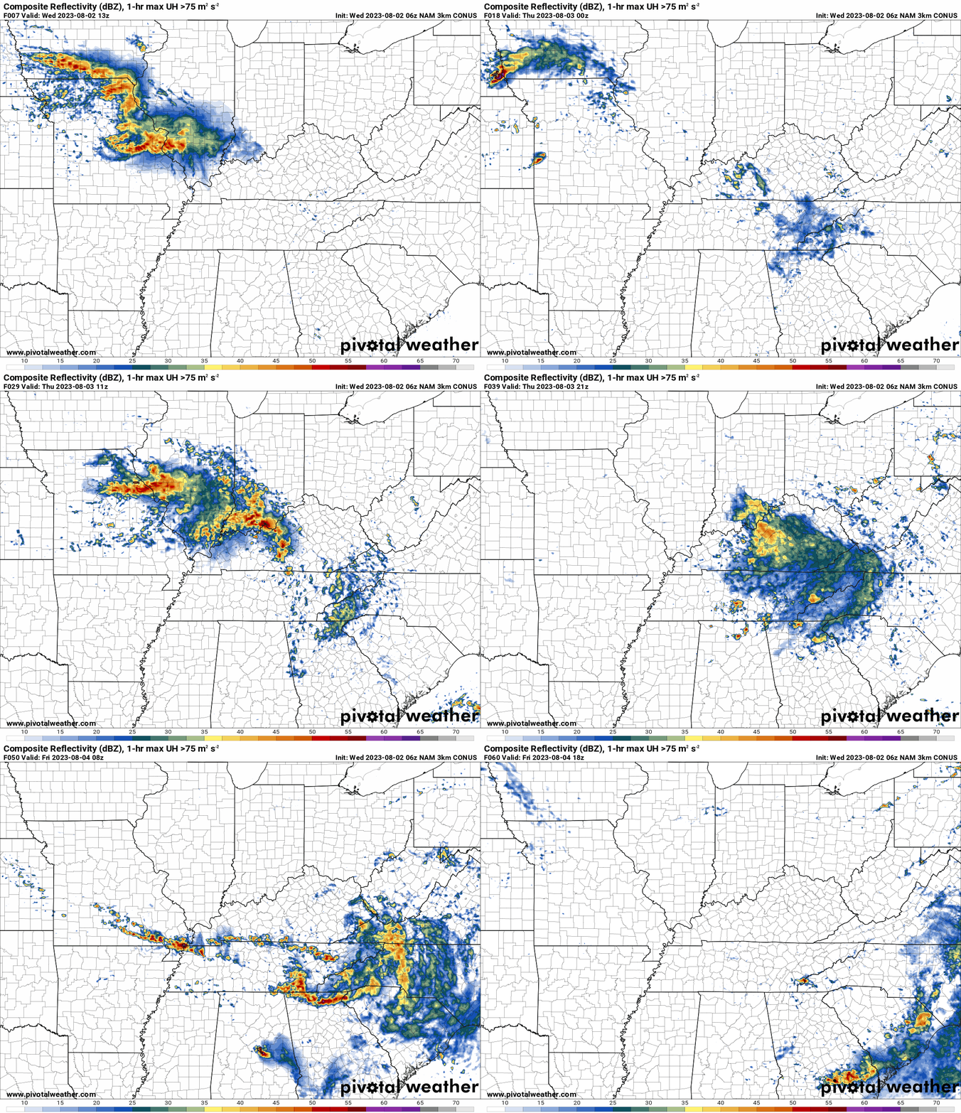
Green represents light rain. Dark green represents moderate rain. Yellow and orange represent heavier rain.
.
This animation is the Hrrr Model.
Occasionally, these maps are in Zulu time. 12z=7 AM. 18z=1 PM. 00z=7 PM. 06z=1 AM
.
This animation is the NAM 3K Model.
Occasionally, these maps are in Zulu time. 12z=7 AM. 18z=1 PM. 00z=7 PM. 06z=1 AM
.
..![]()

.
Click here if you would like to return to the top of the page.
.Average high temperatures for this time of the year are around 90 degrees.
Average low temperatures for this time of the year are around 70 degrees.
Average precipitation during this time period ranges from 0.90″ to 1.20″
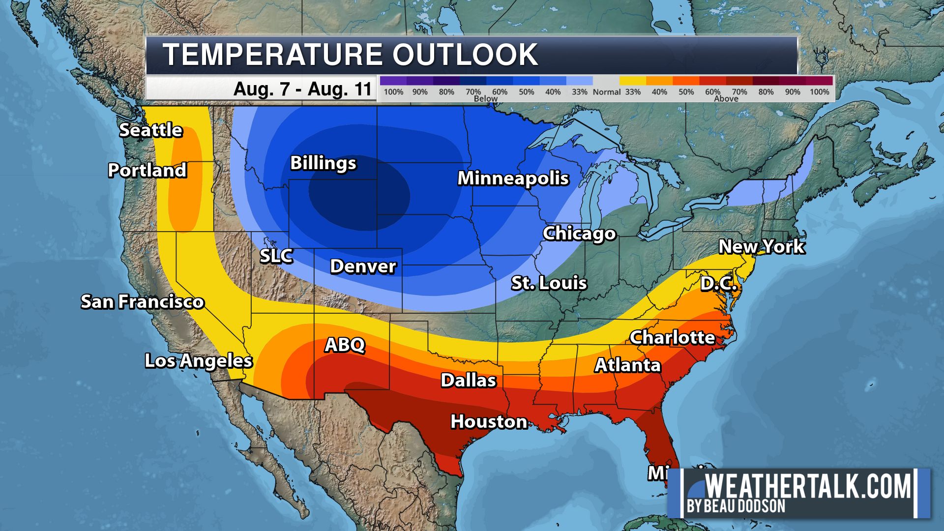
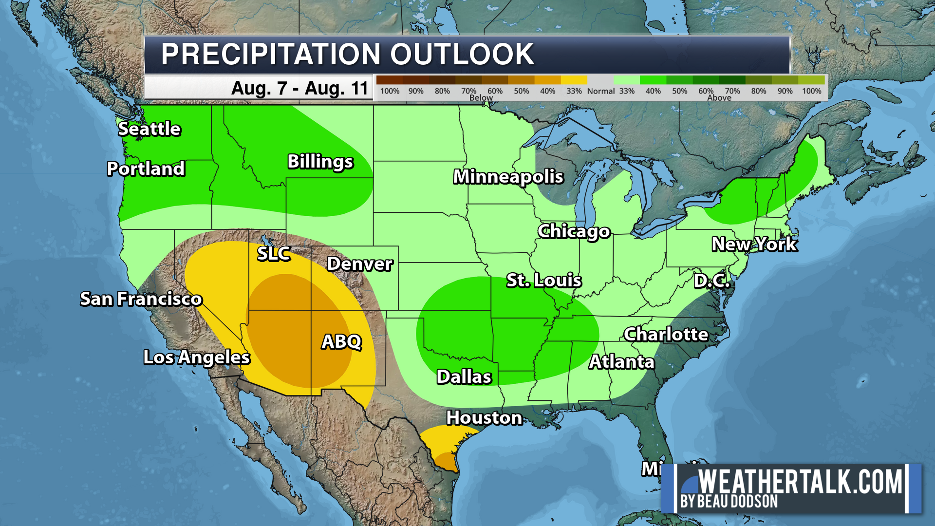
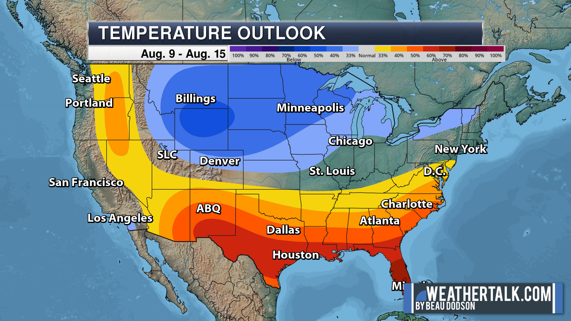
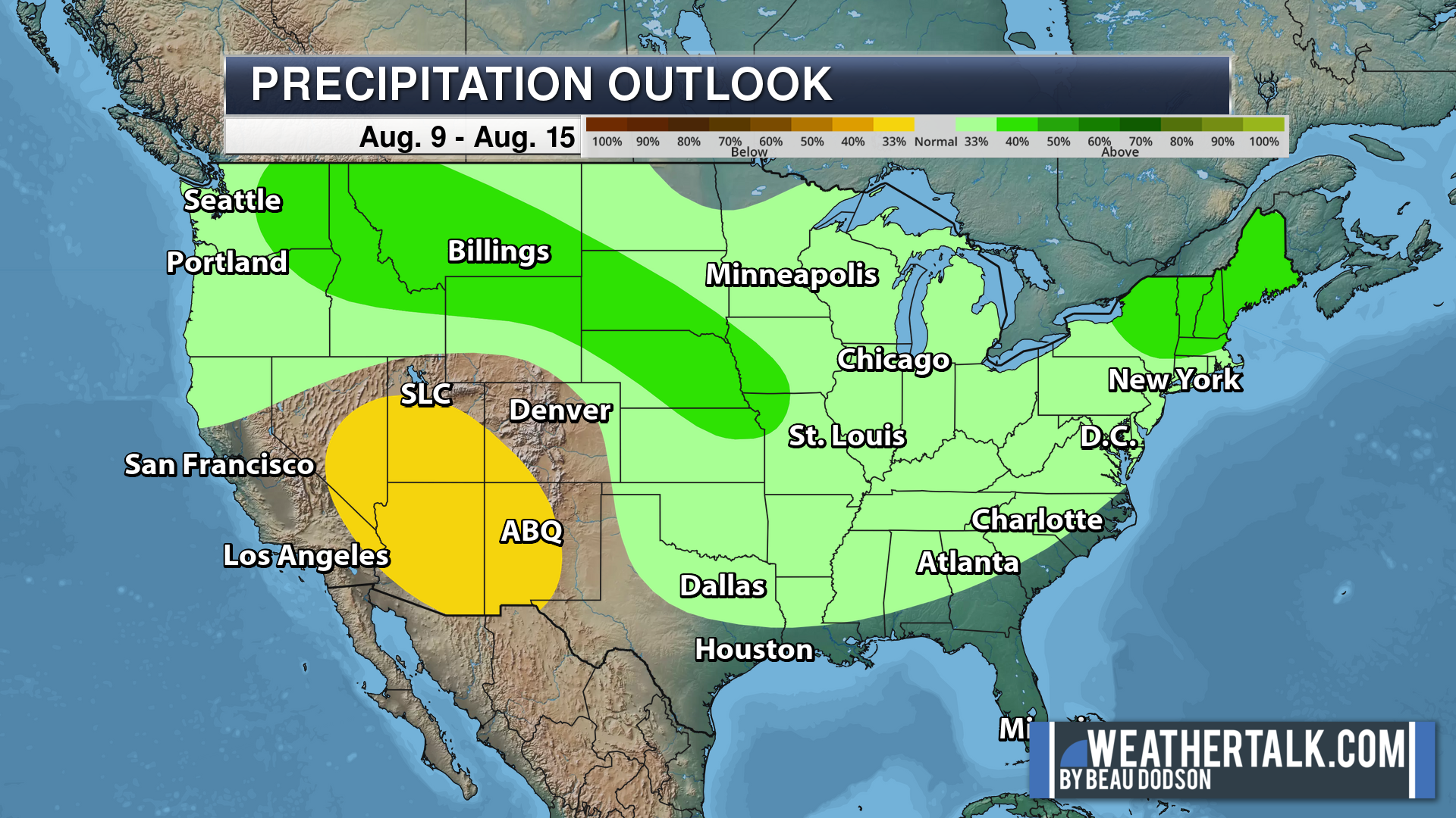
Six to Ten Day Outlook.
Blue is below average. Red is above average. The no color zone represents equal chances.
Average highs for this time of the year are in the lower 60s. Average lows for this time of the year are in the lower 40s.
Green is above average precipitation. Yellow and brown favors below average precipitation. Average precipitation for this time of the year is around one inch per week.
.

Average low temperatures for this time of the year are around 70 degrees.
Average precipitation during this time period ranges from 0.90″ to 1.20″
.
.
![]()
The app is for subscribers. Subscribe at www.weathertalk.com/welcome then go to your app store and search for WeatherTalk
Subscribers, PLEASE USE THE APP. ATT and Verizon are not reliable during severe weather. They are delaying text messages.
The app is under WeatherTalk in the app store.
Apple users click here
Android users click here
.

Radars and Lightning Data
Interactive-city-view radars. Clickable watches and warnings.
https://wtalk.co/B3XHASFZ
If the radar is not updating then try another one. If a radar does not appear to be refreshing then hit Ctrl F5. You may also try restarting your browser.
Backup radar site in case the above one is not working.
https://weathertalk.com/morani
Regional Radar
https://imagery.weathertalk.com/prx/RadarLoop.mp4
** NEW ** Zoom radar with chaser tracking abilities!
ZoomRadar
Lightning Data (zoom in and out of your local area)
https://wtalk.co/WJ3SN5UZ
Not working? Email me at beaudodson@usawx.com
National map of weather watches and warnings. Click here.
Storm Prediction Center. Click here.
Weather Prediction Center. Click here.
.

Live lightning data: Click here.
Real time lightning data (another one) https://map.blitzortung.org/#5.02/37.95/-86.99
Our new Zoom radar with storm chases
.
.

Interactive GOES R satellite. Track clouds. Click here.
GOES 16 slider tool. Click here.
College of DuPage satellites. Click here
.

Here are the latest local river stage forecast numbers Click Here.
Here are the latest lake stage forecast numbers for Kentucky Lake and Lake Barkley Click Here.
.
.
Find Beau on Facebook! Click the banner.








 .
.