
Click one of the links below to take you directly to that section
![]()
![]()
![]()
![]()
![]()
![]()
![]()
.

.
Seven Day Hazardous Weather Outlook
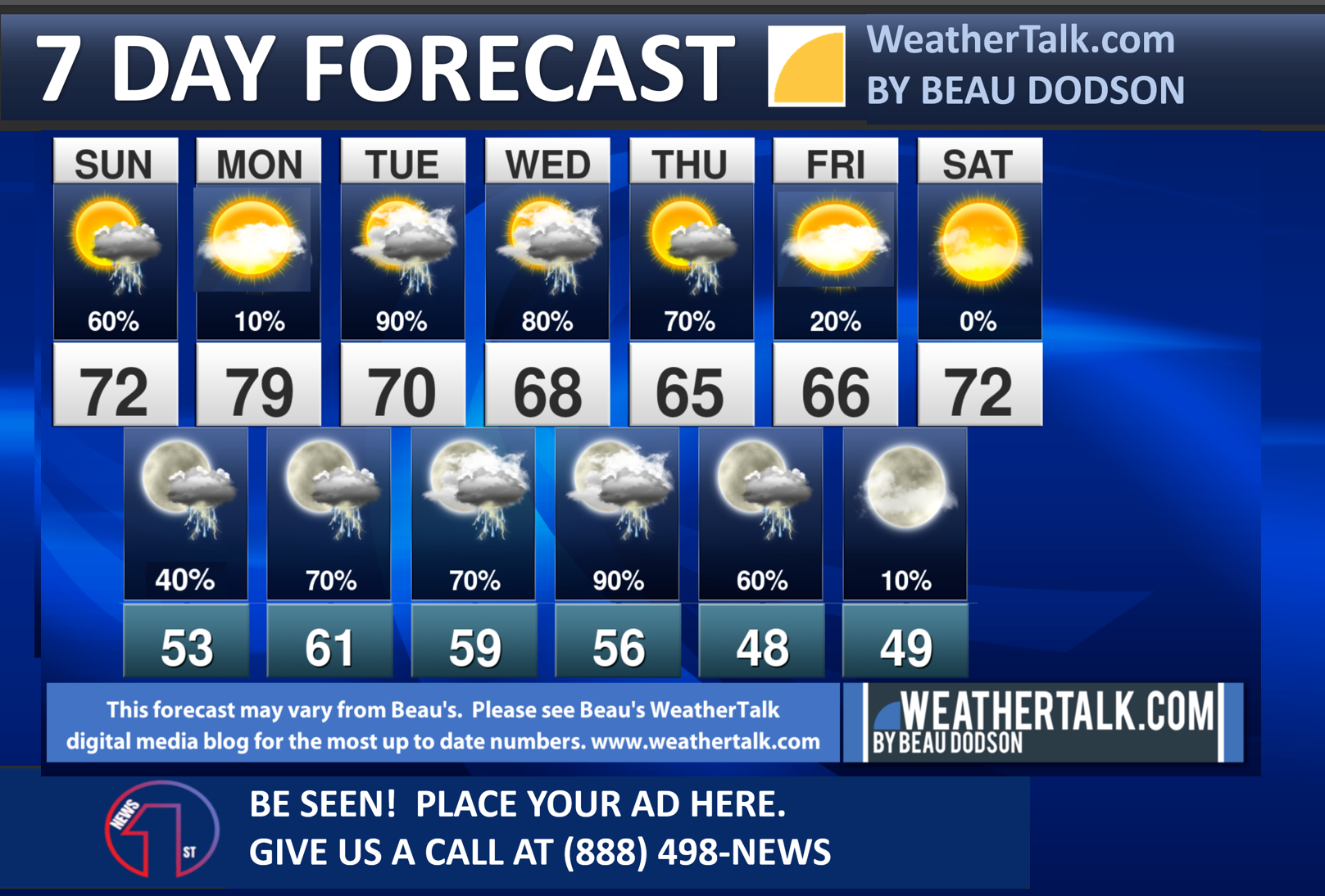
1. Is lightning in the forecast? YES. Lightning is likely this afternoon and evening. Lightning is likely Monday night into Thursday.
2. Are severe thunderstorms in the forecast? POSSIBLE. A few storms could produce high wind and hail this afternoon and evening. An isolated tornado risk, as well. There is a level one and two severe weather risk, at this time. One is the lowest threat level from the Storm Prediction Center.

3. Is flash flooding in the forecast? POSSIBLE. Locally heavy rain is likely Tuesday into Thursday. It is possible that several inches of rain will fall. This will enhance river flooding. There is a crest coming down the Ohio River from Pennsylvania and Ohio. These rain could enhance that. In addition to that, there could be some ponding of water in fields and ditches. Rises in streams are likely, as well. Some flood warnings are possible this week. Monitor updates.
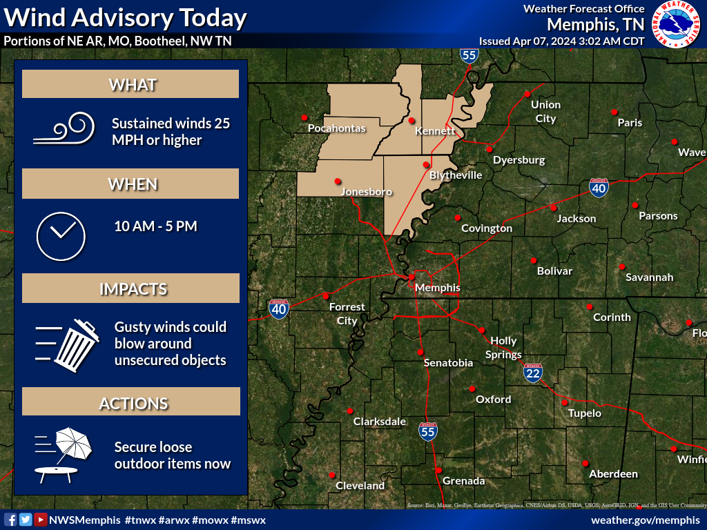
4. Will non-thunderstorm winds top 40 mph? POSSIBLE. Winds will be quite gusty today. Winds could top 40 mph across the Missouri Bootheel where a wind advisory is in effect.
5. Will the heat index exceed 100 degrees? NO.
6. Will the wind chill dip below 10 degrees? NO.
7. Is measurable snow and/or sleet in the forecast? NO.
8. Is freezing rain/ice in the forecast? NO.
Freezing rain is rain that falls and instantly freezes on objects such as trees and power lines Freezing fog possible, as well.
.

Fire weather risk level.
Sunday through Sunday night: 5. Medium risk.
Monday: 6. High Potential.
Monday night: 5. Medium risk.
Fire Weather Discussion
South to southwest transport winds between 20-25 kts and mixing heights around 2.5-5.0 kft AGL will lead to good dispersion today before thunderstorms develop in the afternoon. A wetting rain is possible locally where the strongest storms occur. Although the transport winds will be lighter on Monday, higher mixing heights will support good dispersion. RH values between 20-25% are possible across the Ozark foothills Monday afternoon.
A Haines Index of 6 means a high potential for an existing fire to become large or exhibit erratic fire behavior, 5 means medium potential, 4 means low potential, and anything less than 4 means very low potential.
.

THE FORECAST IS GOING TO VARY FROM LOCATION TO LOCATION.
Scroll down to see your local forecast details.
Seven-day forecast for southeast Missouri, southern Illinois, western Kentucky, and western Tennessee.
This is a BLEND for the region. Scroll down to see the region by region forecast.
48-hour forecast Graphics


.
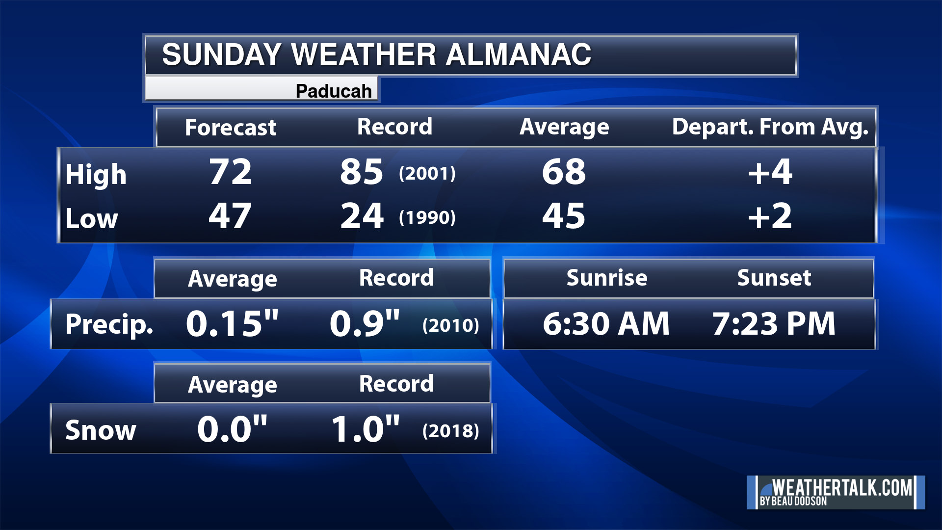
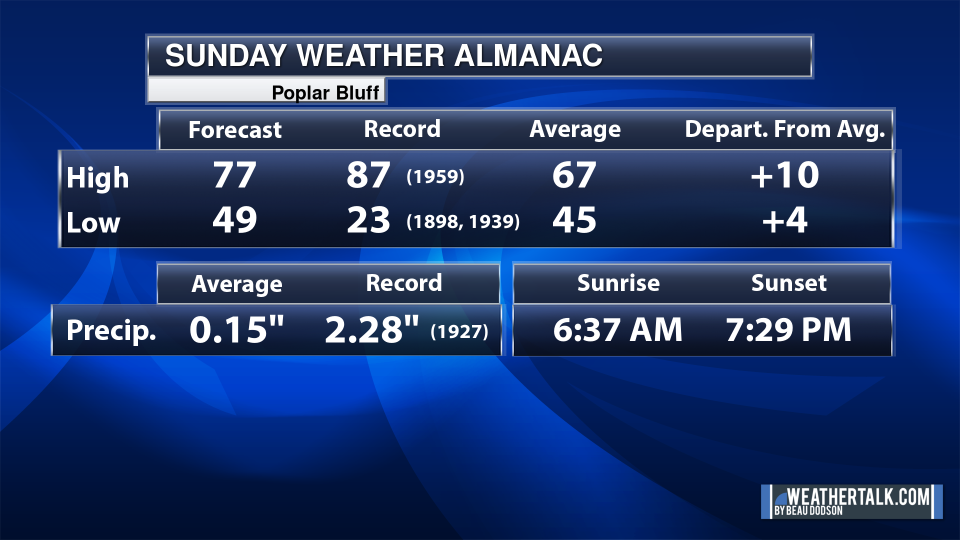
Today’s Local Almanacs (for a few select cities). Your location will be comparable.
Note, the low is this morning’s low and not tomorrows.
The forecast temperature shows you today’s expected high and this morning’s low.
The graphic shows you the record high and record low for today. It shows you what year that occurred, as well.
It then shows you what today’s average temperature is.
It shows you the departures (how may degrees above or below average temperatures will be ).
It shows you the average precipitation for today. Average comes from thirty years of rain totals.
It also shows you the record rainfall for the date and what year that occurred.
The sunrise and sunset are also shown.


![]()
.
.
Sunday Forecast: Partly sunny. A chance of showers and thunderstorms. Some storms could be intense during the afternoon and evening hours.
What is the chance of precipitation?
Far northern southeast Missouri ~ 40%
Southeast Missouri ~ 40%
The Missouri Bootheel ~ 40%
I-64 Corridor of southern Illinois ~ 60%
Southern Illinois ~ 70%
Extreme southern Illinois (southern seven counties) ~ 70%
Far western Kentucky (Purchase area) ~ 70%
The Pennyrile area of western KY ~ 70%
Northwest Kentucky (near Indiana border) ~ 70%
Northwest Tennessee ~ 70%
Coverage of precipitation: Numerous
Timing of the precipitation: Any given point of time
Far northern southeast Missouri ~ 72° to 75°
Southeast Missouri ~ 72° to 74°
The Missouri Bootheel ~ 72° to 74°
I-64 Corridor of southern Illinois ~ 66° to 70°
Southern Illinois ~ 68° to 70°
Extreme southern Illinois (southern seven counties) ~ 70° to 72°
Far western Kentucky ~ 70° to 74°
The Pennyrile area of western KY ~ 70° to 72°
Northwest Kentucky (near Indiana border) ~ 70° to 72°
Northwest Tennessee ~ 70° to 72°
Winds will be from this direction: South southeast 10 to 25 mph
Wind chill or heat index (feels like) temperature forecast: 66° to 74°
What impacts are anticipated from the weather? Wet roadways. Lightning.
Should I cancel my outdoor plans? Have a plan B and monitor the Beau Dodson Weather Radars
UV Index: 6. High
Sunrise: 6:31 AM
Sunset: 7:24 PM
.
Sunday Night Forecast: Mostly cloudy. A chance of a few remaining showers and thunderstorms.
What is the chance of precipitation?
Far northern southeast Missouri ~ 20%
Southeast Missouri ~ 20%
The Missouri Bootheel ~ 20%
I-64 Corridor of southern Illinois ~ 30%
Southern Illinois ~ 40%
Extreme southern Illinois (southern seven counties) ~ 40%
Far western Kentucky (Purchase area) ~ 40%
The Pennyrile area of western KY ~ 60%
Northwest Kentucky (near Indiana border) ~ 40%
Northwest Tennessee ~ 40%
Coverage of precipitation: Scattered – ending west to east
Timing of the precipitation: Mainly before 2 AM
Temperature range:
Far northern southeast Missouri ~ 48° to 52°
Southeast Missouri ~ 48° to 52°
The Missouri Bootheel ~ 50° to 55°
I-64 Corridor of southern Illinois ~ 48° to 52°
Southern Illinois ~ 52° to 55°
Extreme southern Illinois (southern seven counties) ~ 50° to 55°
Far western Kentucky ~ 52° to 55°
The Pennyrile area of western KY ~ 54° to 56°
Northwest Kentucky (near Indiana border) ~ 52° to 55°
Northwest Tennessee ~ 52° to 55°
Winds will be from this direction: South 7 to 14 mph
Wind chill or heat index (feels like) temperature forecast: 48° to 55°
What impacts are anticipated from the weather? Wet roadways. Lightning.
Should I cancel my outdoor plans? No, but check the Beau Dodson Weather Radars
Moonrise: 5:57 AM
Moonset: 6:24 PM
The phase of the moon: Waning Crescent
.
Monday Forecast: A mix of sun and clouds.
What is the chance of precipitation?
Far northern southeast Missouri ~ 0%
Southeast Missouri ~ 0%
The Missouri Bootheel ~ 0%
I-64 Corridor of southern Illinois ~ 0%
Southern Illinois ~ 0%
Extreme southern Illinois (southern seven counties) ~ 0%
Far western Kentucky (Purchase area) ~ 0%
The Pennyrile area of western KY ~ 0%
Northwest Kentucky (near Indiana border) ~ 0%
Northwest Tennessee ~ 0%
Coverage of precipitation:
Timing of the precipitation:
Far northern southeast Missouri ~ 74° to 78°
Southeast Missouri ~ 74° to 78°
The Missouri Bootheel ~ 74° to 78°
I-64 Corridor of southern Illinois ~ 74° to 78°
Southern Illinois ~ 74° to 78°
Extreme southern Illinois (southern seven counties) ~ 74° to 78°
Far western Kentucky ~ 74° to 78°
The Pennyrile area of western KY ~ 74° to 78°
Northwest Kentucky (near Indiana border) ~ 74° to 78°
Northwest Tennessee ~ 74° to 78°
Winds will be from this direction: Southeast 10 to 20 mph
Wind chill or heat index (feels like) temperature forecast: 74° to 78°
What impacts are anticipated from the weather?
Should I cancel my outdoor plans? No
UV Index: 7. High.
Sunrise: 6:30 AM
Sunset: 7:25 PM
.
Monday Night Forecast: Increasing clouds. A chance of showers and thunderstorms.
What is the chance of precipitation?
Far northern southeast Missouri ~ 30%
Southeast Missouri ~ 30%
The Missouri Bootheel ~ 30%
I-64 Corridor of southern Illinois ~ 30%
Southern Illinois ~ 30%
Extreme southern Illinois (southern seven counties) ~ 30%
Far western Kentucky (Purchase area) ~ 30%
The Pennyrile area of western KY ~ 30%
Northwest Kentucky (near Indiana border) ~ 30%
Northwest Tennessee ~ 30%
Coverage of precipitation: Scattered
Timing of the precipitation: Any given point of time.
Temperature range:
Far northern southeast Missouri ~ 54° to 56°
Southeast Missouri ~ 54° to 56°
The Missouri Bootheel ~ 54° to 56°
I-64 Corridor of southern Illinois ~ 54° to 56°
Southern Illinois ~ 54° to 56°
Extreme southern Illinois (southern seven counties) ~ 54° to 56°
Far western Kentucky ~ 56° to 60°
The Pennyrile area of western KY ~ 56° to 60°
Northwest Kentucky (near Indiana border) ~ 54° to 56°
Northwest Tennessee ~ 56° to 60°
Winds will be from this direction: South 10 to 20 mph
Wind chill or heat index (feels like) temperature forecast: 53° to 56°
What impacts are anticipated from the weather?
Should I cancel my outdoor plans? No
Moonrise: 6:25 AM
Moonset: 7:39 PM
The phase of the moon: New
.
Tuesday Forecast: Showers and thunderstorms likely.
What is the chance of precipitation?
Far northern southeast Missouri ~ 90%
Southeast Missouri ~ 90%
The Missouri Bootheel ~ 90%
I-64 Corridor of southern Illinois ~ 90%
Southern Illinois ~ 90%
Extreme southern Illinois (southern seven counties) ~ 90%
Far western Kentucky (Purchase area) ~ 90%
The Pennyrile area of western KY ~ 90%
Northwest Kentucky (near Indiana border) ~ 90%
Northwest Tennessee ~ 90%
Coverage of precipitation: Numerous.
Timing of the precipitation: Any given point of time.
Far northern southeast Missouri ~ 70° to 74°
Southeast Missouri ~ 70° to 74°
The Missouri Bootheel ~ 70° to 74°
I-64 Corridor of southern Illinois ~ 70° to 74°
Southern Illinois ~ 70° to 74°
Extreme southern Illinois (southern seven counties) ~ 70° to 74°
Far western Kentucky ~ 70° to 74°
The Pennyrile area of western KY ~ 70° to 74°
Northwest Kentucky (near Indiana border) ~ 70° to 74°
Northwest Tennessee ~ 70° to 74°
Winds will be from this direction: South southeast 10 t0 2o mph
Wind chill or heat index (feels like) temperature forecast: 70° to 74°
What impacts are anticipated from the weather? Wet roadways. Lightning.
Should I cancel my outdoor plans? Have a plan B and monitor the Beau Dodson Weather Radars
UV Index: 5. Moderate.
Sunrise: 6:29 AM
Sunset: 7:25 PM
.
Tuesday Night Forecast: Showers and thunderstorms likely.
What is the chance of precipitation?
Far northern southeast Missouri ~ 70%
Southeast Missouri ~ 70%
The Missouri Bootheel ~ 70%
I-64 Corridor of southern Illinois ~ 70%
Southern Illinois ~ 70%
Extreme southern Illinois (southern seven counties) ~ 70%
Far western Kentucky (Purchase area) ~ 70%
The Pennyrile area of western KY ~ 70%
Northwest Kentucky (near Indiana border) ~ 70%
Northwest Tennessee ~ 70%
Coverage of precipitation: Numerous.
Timing of the precipitation: Any given point of time.
Temperature range:
Far northern southeast Missouri ~ 54° to 56°
Southeast Missouri ~ 54° to 56°
The Missouri Bootheel ~ 54° to 56°
I-64 Corridor of southern Illinois ~ 54° to 56°
Southern Illinois ~ 54° to 56°
Extreme southern Illinois (southern seven counties) ~ 54° to 56°
Far western Kentucky ~ 56° to 60°
The Pennyrile area of western KY ~ 56° to 60°
Northwest Kentucky (near Indiana border) ~ 54° to 56°
Northwest Tennessee ~ 56° to 60°
Winds will be from this direction: South southeast 10 to 20 mph
Wind chill or heat index (feels like) temperature forecast: 53° to 56°
What impacts are anticipated from the weather? Wet roadways. Lightning.
Should I cancel my outdoor plans? Have a plan B and monitor the Beau Dodson Weather Radars
Moonrise: 6:54 AM
Moonset: 8:55 PM
The phase of the moon: Waxing Crescent
.
Wednesday Forecast: Showers and thunderstorms likely.
What is the chance of precipitation?
Far northern southeast Missouri ~ 90%
Southeast Missouri ~ 90%
The Missouri Bootheel ~ 90%
I-64 Corridor of southern Illinois ~ 80%
Southern Illinois ~ 80%
Extreme southern Illinois (southern seven counties) ~ 80%
Far western Kentucky (Purchase area) ~ 80%
The Pennyrile area of western KY ~ 80%
Northwest Kentucky (near Indiana border) ~ 80%
Northwest Tennessee ~ 90%
Coverage of precipitation: Numerous.
Timing of the precipitation: Any given point of time.
Far northern southeast Missouri ~ 68° to 72°
Southeast Missouri ~ 68° to 72°
The Missouri Bootheel ~ 68° to 72°
I-64 Corridor of southern Illinois ~ 68° to 72°
Southern Illinois ~ 68° to 72°
Extreme southern Illinois (southern seven counties) ~ 68° to 72°
Far western Kentucky ~ 68° to 72°
The Pennyrile area of western KY ~ 68° to 72°
Northwest Kentucky (near Indiana border) ~ 68° to 72°
Northwest Tennessee ~ 68° to 72°
Winds will be from this direction: South southeast 10 t0 2o mph
Wind chill or heat index (feels like) temperature forecast: 68° to 72°
What impacts are anticipated from the weather? Wet roadways. Lightning.
Should I cancel my outdoor plans? Have a plan B and monitor the Beau Dodson Weather Radars
UV Index: 3. Moderate.
Sunrise: 6:27 AM
Sunset: 7:26 PM
.
Wednesday Night Forecast: Showers and thunderstorms likely.
What is the chance of precipitation?
Far northern southeast Missouri ~ 90%
Southeast Missouri ~ 90%
The Missouri Bootheel ~ 90%
I-64 Corridor of southern Illinois ~ 90%
Southern Illinois ~ 90%
Extreme southern Illinois (southern seven counties) ~ 90%
Far western Kentucky (Purchase area) ~ 90%
The Pennyrile area of western KY ~ 90%
Northwest Kentucky (near Indiana border) ~ 90%
Northwest Tennessee ~ 90%
Coverage of precipitation: Numerous.
Timing of the precipitation: Any given point of time.
Temperature range:
Far northern southeast Missouri ~ 48° to 52°
Southeast Missouri ~ 48° to 52°
The Missouri Bootheel ~ 48° to 52°
I-64 Corridor of southern Illinois ~ 48° to 52°
Southern Illinois ~ 48° to 52°
Extreme southern Illinois (southern seven counties) ~ 48° to 52°
Far western Kentucky ~ 48° to 52°
The Pennyrile area of western KY ~ 48° to 52°
Northwest Kentucky (near Indiana border) ~ 48° to 52°
Northwest Tennessee ~ 48° to 52°
Winds will be from this direction: South southeast 10 to 20 mph
Wind chill or heat index (feels like) temperature forecast: 48° to 52°
What impacts are anticipated from the weather? Wet roadways. Lightning.
Should I cancel my outdoor plans? Have a plan B and monitor the Beau Dodson Weather Radars
Moonrise: 7:26 AM
Moonset: 10:11 PM
The phase of the moon: Waxing Crescent
.
Click here if you would like to return to the top of the page.

-
- Showers and thunderstorms this afternoon and evening.
- Watching Monday’s eclipse forecast. Some clouds, but how much cloud cover?
- Shower and thunderstorm chances Monday night into Wednesday.
Weather advice:
Do you have any suggestions or comments? Email me at beaudodson@usawx.com
Make sure you have three to five ways of receiving your severe weather information.
Weather Talk is one of those ways.
.
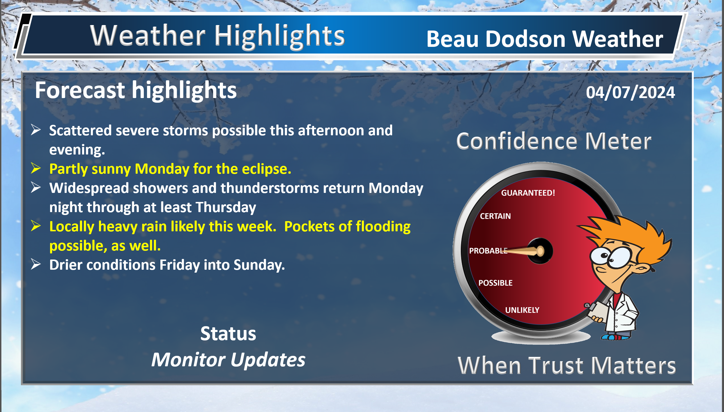
Beau’s Forecast Discussion
Good day, everyone.
A very active weather pattern ahead of us.
Forecast
Today and tonight:
A cold front will push into the region later today and this evening. Showers and thunderstorms will develop along and ahead of the cold front. We do have a chance of severe weather.
The Storm Prediction Center has outlined a level one and two risk for the region.
There are some limiting factors that raise questions about the severe weather risk this afternoon and evening.
Dew point recover is one question. Dew point is a measure of moisture. We generally look for dew points of 58 degrees and above when thinking about severe weather.
Here are the early morning dew point readings.
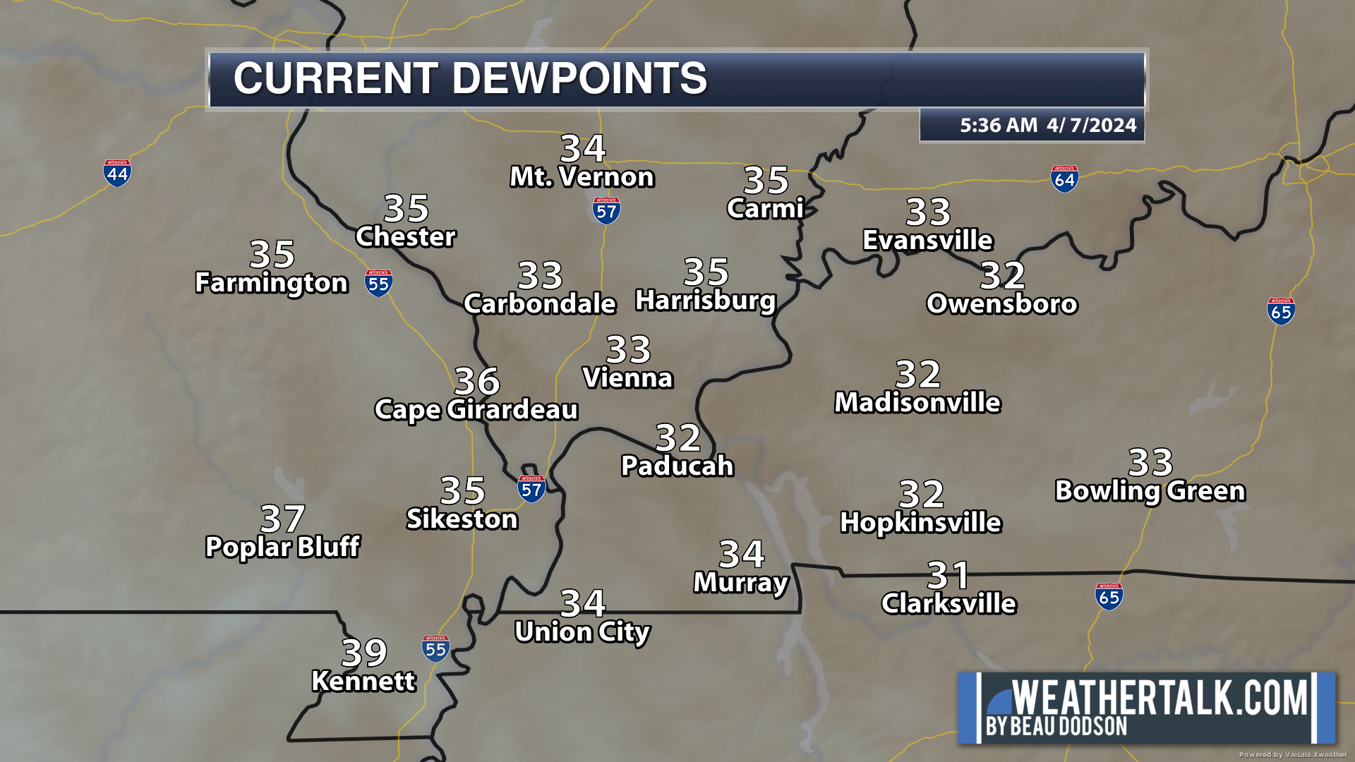
If we zoom out, we can see higher dew points to our south.
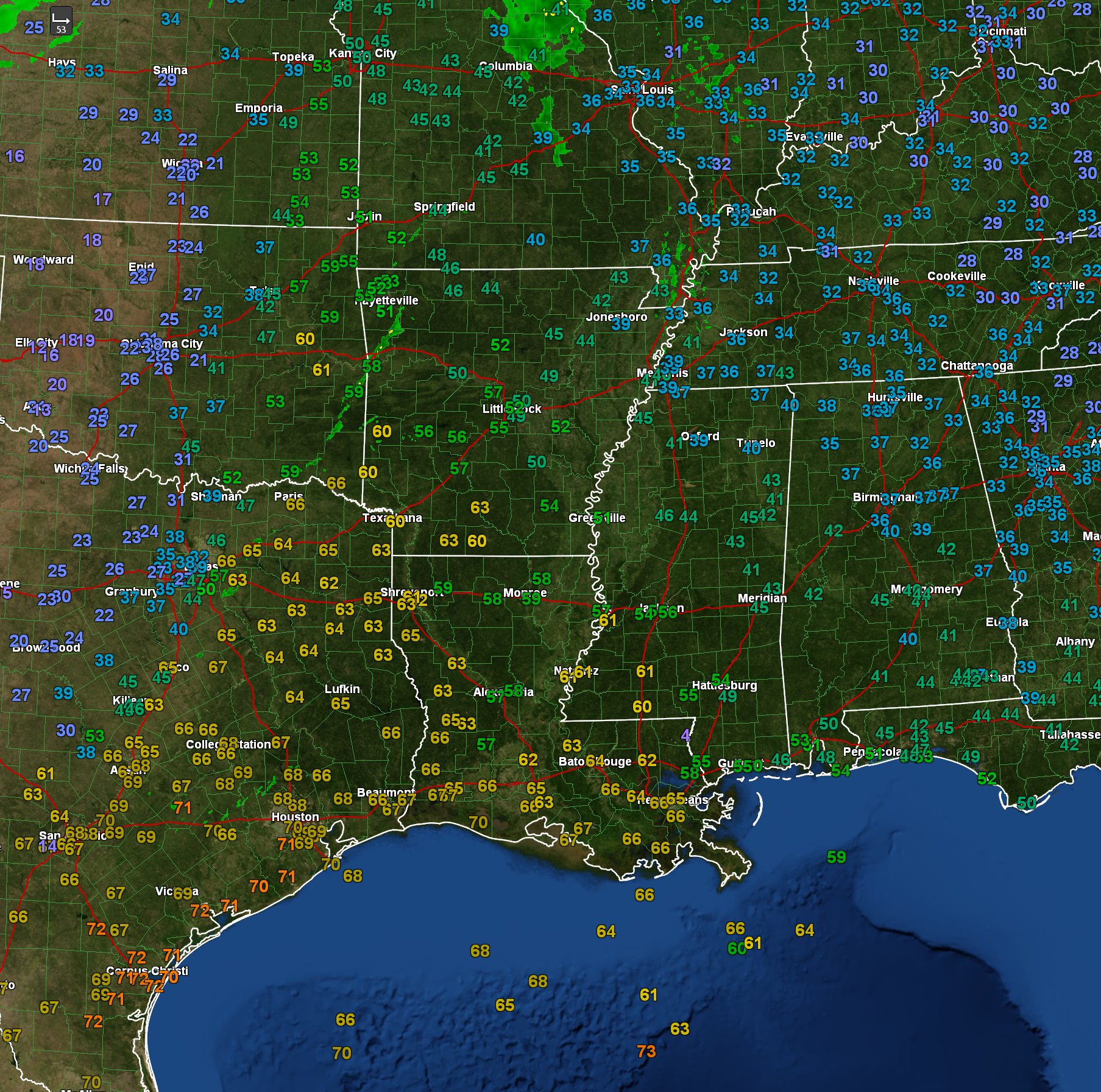
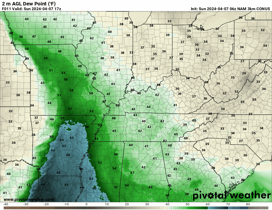
Here is the dew point animation. You can see the front pulls higher dew points northward later today.
Double click on images to enlarge them.
If dew points recover later today, then the risk of severe weather will be an issue.
There is also some dry air aloft moving in from the west. This raises questions about the threat of severe weather, as well.
Overall, confidence is lower than average for this severe weather event. The concern would be a few reports of damaging wind, large hail, and a tornado or two.
Stay weather aware this afternoon and evening as thunderstorms develop and move through the region.
We will dry out later tonight into most of Monday.
High cirrus clouds continue to be a concern for the eclipse, but low clouds appear unlikely. It is possible the cirrus clouds cause some viewing issues, but that is better than low clouds.
Some patchy cumulus clouds will form during the afternoon, as well.
I hope everyone is able to view the eclipse. Get into the totality area. There is nothing like it! It is amazing.
Widespread showers and thunderstorms return to the forecast late Monday night into Thursday.
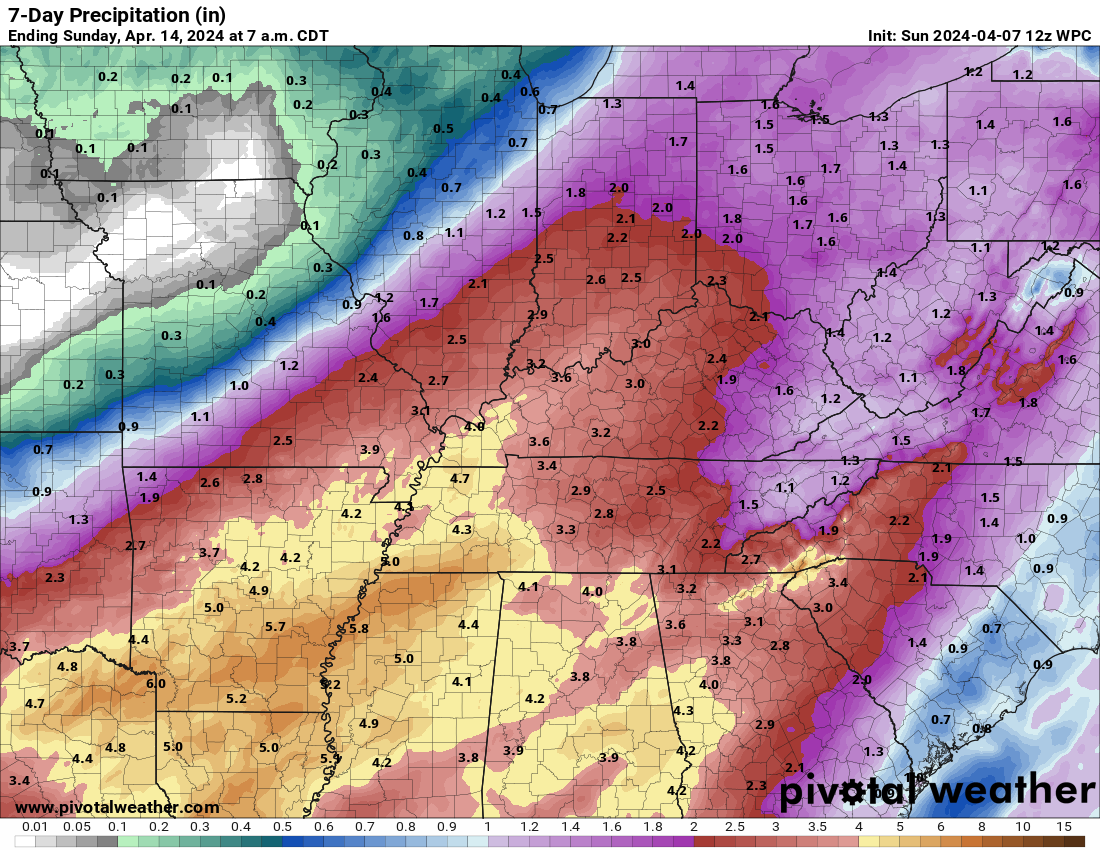
Locally heavy rain is a concern with some flash flood or flood warnings possible as we move through the week.
The latest WPC/NOAA rainfall totals continue to show heavy rain.
The Memphis, Tennessee National Weather Service posted this graphic. Some big totals are showing up in some of the model data.
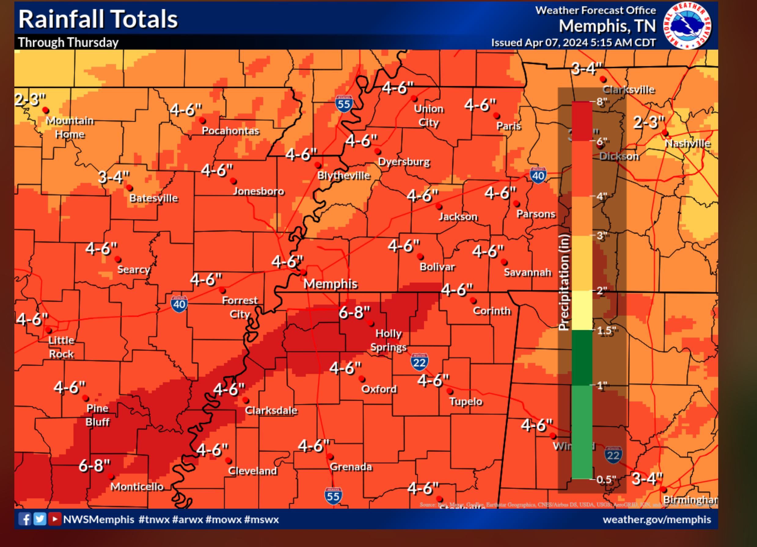
Peak rain chances will be Tuesday, Wednesday, and Thursday.
A wet week ahead of us!
We currently are forecasting the threat of severe weather to stay to our south Tuesday through Thursday, but I will keep a close eye on it. If the low tracks a bit farther northwest, then a severe threat could slip into our region. I am watching Wednesday and Thursday, in particular. But, for now, I have kept severe storms out of the forecast.
Stay updated on future forecasts, as always.
![]()
.
Click here if you would like to return to the top of the page.
This outlook covers southeast Missouri, southern Illinois, western Kentucky, and far northwest Tennessee.

.
Today’s Storm Prediction Center’s (SPC) Severe Weather Outlook
Light green is where thunderstorms may occur but should be below severe levels.
Dark green is a level one risk. Yellow is a level two risk. Orange is a level three (enhanced) risk. Red is a level four (moderate) risk. Pink is a level five (high) risk.
One is the lowest risk. Five is the highest risk.
A severe storm is one that produces 58 mph wind or higher, quarter or larger size hail, and/or a tornado.
Explanation of tables. Click here.
Day One Severe Weather Outlook

Day One Severe Weather Outlook. Zoomed in on our region.
.
Day One Tornado Probability Outlook

Day One Regional Tornado Outlook. Zoomed in on our region.

.
Day One Large Hail Probability Outlook

Day One Regional Hail Outlook. Zoomed in on our region.

.
Day One High wind Probability Outlook

Day One Regional Wind Outlook. Zoomed in on our region.

.
Tomorrow’s severe weather outlook. Day two outlook.

Day Two Outlook. Zoomed in on our region.

.
Day Three Severe Weather Outlook

.

.
The images below are from NOAA’s Weather Prediction Center.
24-hour precipitation outlook..
 .
.
.
48-hour precipitation outlook.
. .
.
![]()
_______________________________________
.

Click here if you would like to return to the top of the page.
Again, as a reminder, these are models. They are never 100% accurate. Take the general idea from them.
What should I take from these?
- The general idea and not specifics. Models usually do well with the generalities.
- The time-stamp is located in the upper left corner.
.
What am I looking at?
You are looking at computer model data. Meteorologists use many different models to forecast the weather.
Occasionally, these maps are in Zulu time. 12z=7 AM. 18z=1 PM. 00z=7 PM. 06z=1 AM
Green represents light rain. Dark green represents moderate rain. Yellow and orange represent heavier rain.
.
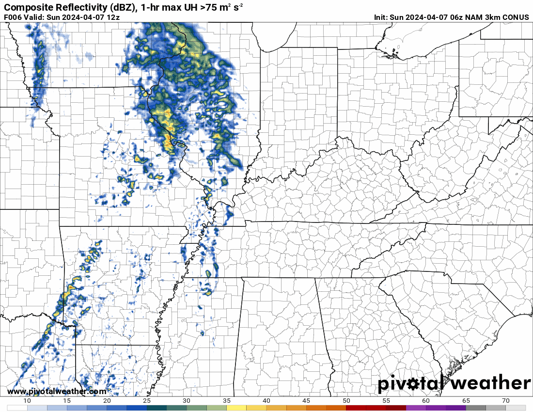
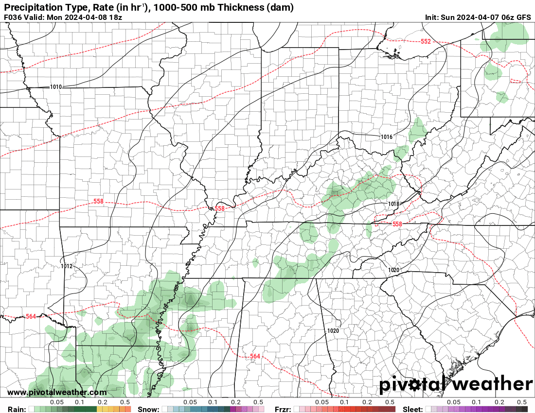
This animation is the NAM Model.
Occasionally, these maps are in Zulu time. 12z=7 AM. 18z=1 PM. 00z=7 PM. 06z=1 AM
Double click images to enlarge them.
.
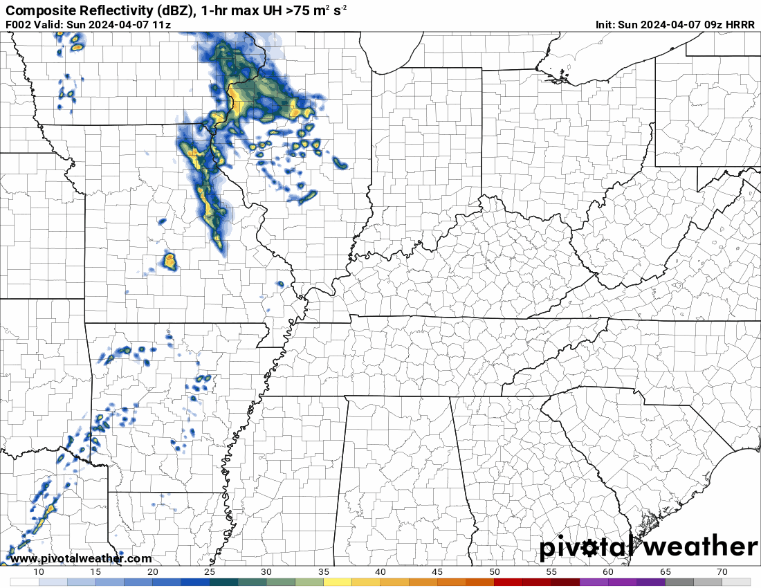
This animation is the HRRR Model.
Green is rain. Yellow and orange are heavier rain. Pink is a wintry mix. Blue is snow. Dark blue is heavier snow.
Occasionally, these maps are in Zulu time. 12z=7 AM. 18z=1 PM. 00z=7 PM. 06z=1 AM
Double click images to enlarge them.
.
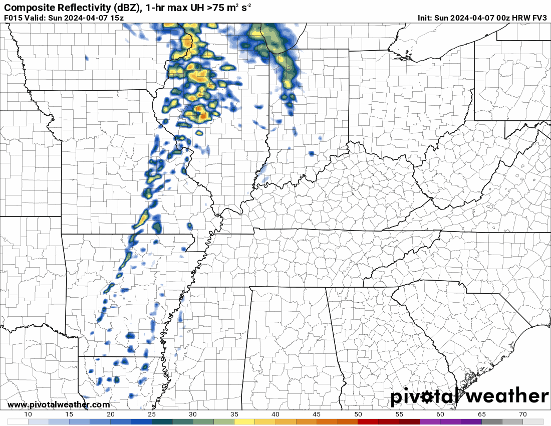
This animation is the FVS Model.
Green is rain. Yellow and orange are heavier rain. Pink is a wintry mix. Blue is snow. Dark blue is heavier snow.
Occasionally, these maps are in Zulu time. 12z=7 AM. 18z=1 PM. 00z=7 PM. 06z=1 AM
Double click images to enlarge them.
.
This animation is the GFS Model.
Green is rain. Yellow and orange are heavier rain. Pink is a wintry mix. Blue is snow. Dark blue is heavier snow.
Occasionally, these maps are in Zulu time. 12z=7 AM. 18z=1 PM. 00z=7 PM. 06z=1 AM
Double click images to enlarge them.
.
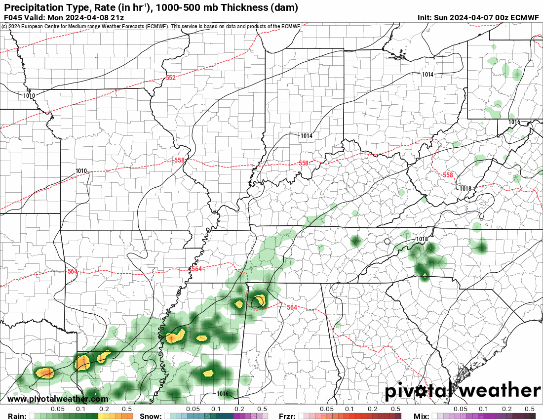
This animation is the EC Model.
Green is rain. Yellow and orange are heavier rain. Pink is a wintry mix. Blue is snow. Dark blue is heavier snow.
Occasionally, these maps are in Zulu time. 12z=7 AM. 18z=1 PM. 00z=7 PM. 06z=1 AM
Double click images to enlarge them.
.
..![]()

.
Click here if you would like to return to the top of the page.
.Average high temperatures for this time of the year are around 66 degrees.
Average low temperatures for this time of the year are around 44 degrees.
Average precipitation during this time period ranges from 0.80″ to 1.60″
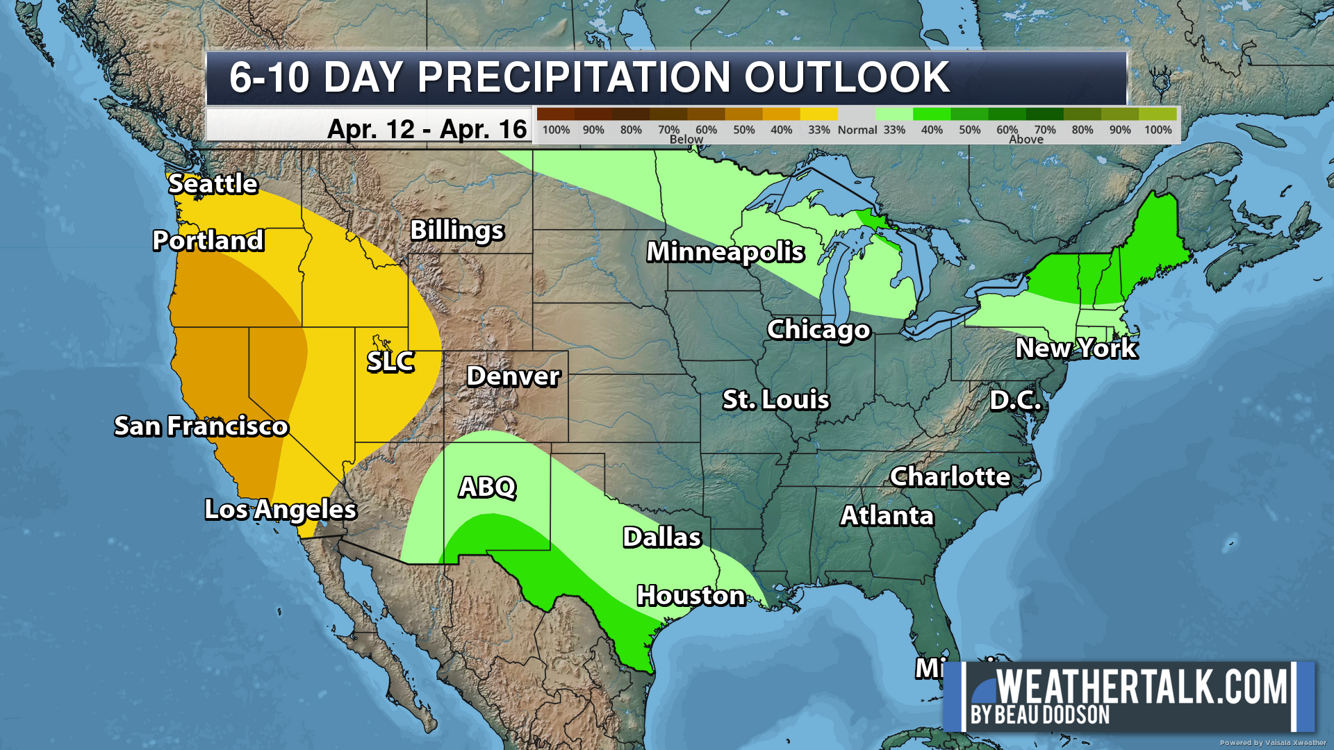
Six to Ten Day Outlook.
Blue is below average. Red is above average. The no color zone represents equal chances.
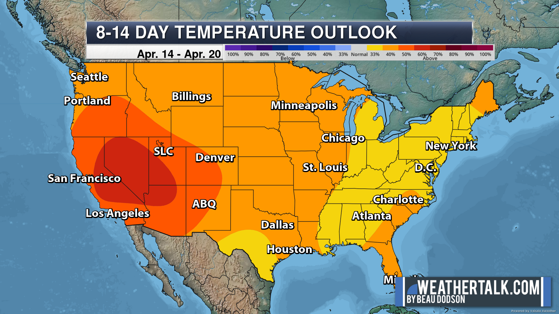
Average highs for this time of the year are in the lower 60s. Average lows for this time of the year are in the lower 40s.
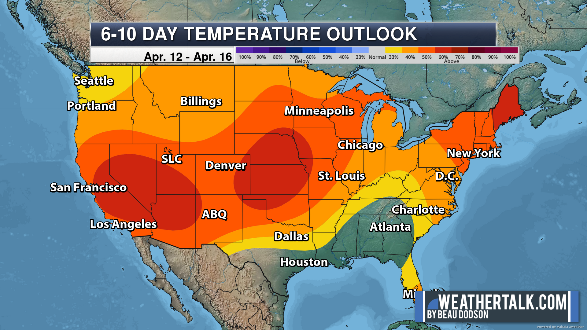
Green is above average precipitation. Yellow and brown favors below average precipitation. Average precipitation for this time of the year is around one inch per week.
.

Average low temperatures for this time of the year are around 45 degrees.
Average precipitation during this time period ranges from 0.80″ to 1.60″
.
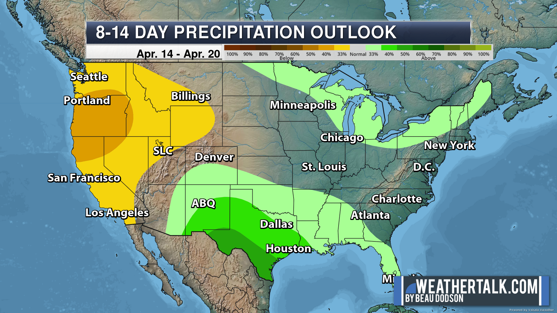
Eight to Fourteen Day Outlook.
Blue is below average. Red is above average. The no color zone represents equal chances.
Green is above average precipitation. Yellow and brown favors below average precipitation. Average precipitation for this time of the year is around one inch per week.
.
![]()
The app is for subscribers. Subscribe at www.weathertalk.com/welcome then go to your app store and search for WeatherTalk
Subscribers, PLEASE USE THE APP. ATT and Verizon are not reliable during severe weather. They are delaying text messages.
The app is under WeatherTalk in the app store.

Apple users click here

Android users click here
.

Radars and Lightning Data
Interactive-city-view radars. Clickable watches and warnings.
https://wtalk.co/B3XHASFZ
If the radar is not updating then try another one. If a radar does not appear to be refreshing then hit Ctrl F5. You may also try restarting your browser.
Backup radar site in case the above one is not working.
https://weathertalk.com/morani
Regional Radar
https://imagery.weathertalk.com/prx/RadarLoop.mp4
** NEW ** Zoom radar with chaser tracking abilities!
ZoomRadar
Lightning Data (zoom in and out of your local area)
https://wtalk.co/WJ3SN5UZ
Not working? Email me at beaudodson@usawx.com
National map of weather watches and warnings. Click here.
Storm Prediction Center. Click here.
Weather Prediction Center. Click here.
.

Live lightning data: Click here.
Real time lightning data (another one) https://map.blitzortung.org/#5.02/37.95/-86.99
Our new Zoom radar with storm chases
.
.

Interactive GOES R satellite. Track clouds. Click here.
GOES 16 slider tool. Click here.
College of DuPage satellites. Click here
.

Here are the latest local river stage forecast numbers Click Here.
Here are the latest lake stage forecast numbers for Kentucky Lake and Lake Barkley Click Here.
.
.
Find Beau on Facebook! Click the banner.


 .
.