.
Click one of the links below to take you directly to that section
Do you have any suggestions or comments? Email me at beaudodson@usawx.com
.
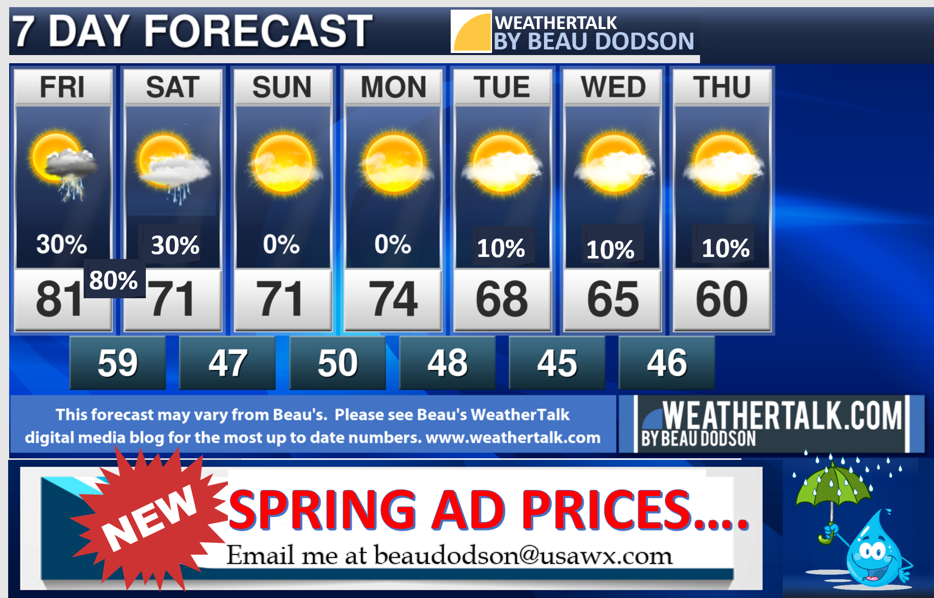
7-day forecast for southeast Missouri, southern Illinois, western Kentucky, and western Tennessee.
This is a BLEND for the region. See the detailed region by region forecast further down in this post.
.


.
.

.
Wednesday to Wednesday
1. Is lightning in the forecast? Yes. Lightning will be possible Wednesday and Wednesday night. Friday, Friday night, and early Saturday morning.
2. Are severe thunderstorms in the forecast? Monitor. I am watching Friday afternoon and night.
The NWS officially defines a severe thunderstorm as a storm with 58 mph wind or greater, 1″ hail or larger, and/or tornadoes
3. Is flash flooding in the forecast? Monitor. A few storms could produce heavy rain Friday afternoon and night.
4. Will the wind chill dip below 10 degrees above zero? No.
5: Will there be accumulating snow and ice in the forecast? No.
.
.
April 7, 2021
How confident am I that this days forecast will verify? High confidence
Wednesday Forecast: Increasing clouds. A few showers and thunderstorms will be possible before 2 PM. Then, shower and thunderstorm chances will ramp up east to west.
What is the chance of precipitation? SE MO ~ 70% MO Bootheel ~ 70% I-64 Corridor South IL ~ 70% South IL ~ 70% West KY ~ 70% NW KY (near Indiana border) ~ 70% NW TN ~ 70%
Coverage of precipitation: Widely scattered during the morning. Becoming numerous late in the day (west to east).
Timing of the rain: Scattered morning. Becoming more widespread during the afternoon.
Temperature range: MO Bootheel 74° to 76° SE MO 74° to 76° South IL 74° to 76° Northwest KY (near Indiana border) 74° to 76° West KY 75° to 80° NW TN 75° to 80°
Wind direction and speed: South southwest at 10 to 20 mph. Gusty.
Wind chill or heat index (feels like) temperature forecast: 74° to 80°
What impacts are anticipated from the weather? Wet roadways. Lightning. A few storms could produce gusty wind and small hail.
Should I cancel my outdoor plans? No, but monitor updates.
UV Index: 7. High.
Sunrise: 6:32 AM
Sunset: 7:23 PM
.
Wednesday night Forecast: Cloudy. Showers and thunderstorms.
What is the chance of precipitation? SE MO ~ 70% MO Bootheel ~ 70% I-64 Corridor South IL ~ 100% South IL ~ 100% West KY ~ 90% NW KY (near Indiana border) ~ 100% NW TN ~ 90%
Coverage of precipitation: Numerous.
Timing of the rain: Any given time.
Temperature range: MO Bootheel 54° to 56° SE MO 52° to 55° South IL 52° to 55° Northwest KY (near Indiana border) 52° to 55° West KY 52° to 55° NW TN 53° to 56°
Wind direction and speed: South southwest 10 to 20 mph. Gusty.
Wind chill or heat index (feels like) temperature forecast: 52° to 56°
What impacts are anticipated from the weather? Wet roadways. Lightning. A few storms could produce gusty wind and small hail.
Should I cancel my outdoor plans? Have a plan B. Check radars.
Moonrise: 4:43 AM
Moonset: 3:13 PM
The phase of the moon: Waning Crescent
.
April 8, 2021
How confident am I that this days forecast will verify? High confidence
Thursday Forecast: Intervals of clouds. Most likely dry.
What is the chance of precipitation? SE MO ~ 10% MO Bootheel ~ 10% I-64 Corridor South IL ~ 10% South IL ~ 20% West KY ~ 20% NW KY (near Indiana border) ~ 20% NW TN ~ 20%
Coverage of precipitation: Most likely none
Timing of the rain: N/A
Temperature range: MO Bootheel 66° to 68° SE MO 64° to 68° South IL 64° to 68° Northwest KY (near Indiana border) 64° to 68° West KY 64° to 68° NW TN 66° to 68°
Wind direction and speed: Southwest 10 to 20 mph. Gusty.
Wind chill or heat index (feels like) temperature forecast: 62° to 68°
What impacts are anticipated from the weather? Most likely dry.
Should I cancel my outdoor plans? No
UV Index: 7. High.
Sunrise: 6:30 AM
Sunset: 7:24 PM
.
Thursday night Forecast: Partly cloudy. A slight chance of showers. Most areas will remain dry.
What is the chance of precipitation? SE MO ~ 0% MO Bootheel ~ 0% I-64 Corridor South IL ~ 0% South IL ~ 0% West KY ~ 0% NW KY (near Indiana border) ~ 0% NW TN ~ 0%
Coverage of precipitation: None
Timing of the rain: N/A
Temperature range: MO Bootheel 50° to 52° SE MO 46° to 52° South IL 46° to 52° Northwest KY (near Indiana border) 48° to 52° West KY 48° to 52° NW TN 50° to 52°
Wind direction and speed: South southwest becoming west at 8 to 16 mph. Gusty.
Wind chill or heat index (feels like) temperature forecast: 45° to 50°
What impacts are anticipated from the weather? None
Should I cancel my outdoor plans? No
Moonrise: 5:14 AM
Moonset: 4:15 PM
The phase of the moon: Waning Crescent
.
April 9, 2021
How confident am I that this days forecast will verify? High confidence
Friday Forecast: Mostly sunny. Warm. Scattered afternoon thunderstorms. Some could be intense.
What is the chance of precipitation? SE MO ~ 50% MO Bootheel ~ 50% I-64 Corridor South IL ~ 30% South IL ~ 40% West KY ~ 40% NW KY (near Indiana border) ~ 30% NW TN ~ 50%
Coverage of precipitation: Scattered
Timing of the rain: Afternoon
Temperature range: MO Bootheel 80° to 82° SE MO 76° to 80° South IL 76° to 80° Northwest KY (near Indiana border) 76° to 80° West KY 78° to 80° NW TN 78° to 82°
Wind direction and speed: South 10 to 25 mph. Gusty.
Wind chill or heat index (feels like) temperature forecast: 76° to 82°
What impacts are anticipated from the weather? Wet roadways. Lightning. Locally heavy rain. Gusty wind in storms. Hail in storms.
Should I cancel my outdoor plans? No, but monitor updates.
UV Index: 8. High.
Sunrise: 6:30 AM
Sunset: 7:24 PM
.
Friday night Forecast: Cloudy with showers and thunderstorms. Some storms could be heavy.
What is the chance of precipitation? SE MO ~ 90% MO Bootheel ~ 100% I-64 Corridor South IL ~ 90% South IL ~ 90% West KY ~ 90% NW KY (near Indiana border) ~ 90% NW TN ~ 100%
Coverage of precipitation: Numerous
Timing of the rain: Any given time.
Temperature range: MO Bootheel 52° to 55° SE MO 52° to 55° South IL 52° to 55° Northwest KY (near Indiana border) 52° to 55° West KY 52° to 55° NW TN 54° to 56°
Wind direction and speed: South southeast at 7 to 14 mph. Higher gusts.
Wind chill or heat index (feels like) temperature forecast: 50° to 55°
What impacts are anticipated from the weather? Wet roadways. Lightning. Some storms could be intense.
Should I cancel my outdoor plans? No, but check radars.
Moonrise: 5:14 AM
Moonset: 4:15 PM
The phase of the moon: Waning Crescent
.
April 10, 2021
How confident am I that this days forecast will verify? High confidence
Saturday Forecast: A chance of morning showers and thunderstorms. Intervals of clouds. Cooler. Breezy.
What is the chance of precipitation? SE MO ~ 30% MO Bootheel ~ 30% I-64 Corridor South IL ~ 40% South IL ~ 40% West KY ~ 40% NW KY (near Indiana border) ~ 40% NW TN ~ 30%
Coverage of precipitation: Scattered/ending early in the day.
Timing of the rain: Mainly before 10 AM.
Temperature range: MO Bootheel 66° to 70° SE MO 64° to 68° South IL 64° to 68° Northwest KY (near Indiana border) 64° to 68° West KY 64° to 68° NW TN 66° to 70°
Wind direction and speed: Southwest to west at 10 to 20 mph. Higher gusts.
Wind chill or heat index (feels like) temperature forecast: 64° to 70°
What impacts are anticipated from the weather? Wet roadways. Lightning. Precipitation will end early in the morning.
Should I cancel my outdoor plans? No, but check radars early in the day.
UV Index: 6. High.
Sunrise: 6:28 AM
Sunset: 7:26 PM
.
Saturday night Forecast: Decreasing clouds. A chance of a light shower over northern portions of southern Illinois and northwest Kentucky.
What is the chance of precipitation? SE MO ~ 10% MO Bootheel ~ 10% I-64 Corridor South IL ~ 30% South IL ~ 20% West KY ~ 20% NW KY (near Indiana border) ~ 30% NW TN ~ 20%
Coverage of precipitation: Widely scattered (northern counties). Lower chance across the rest of the region.
Timing of the rain: Before 4 AM.
Temperature range: MO Bootheel 46° to 48° SE MO 44° to 48° South IL 44° to 48° Northwest KY (near Indiana border) 44° to 48° West KY 44° to 48° NW TN 44° to 48°
Wind direction and speed: West northwest 8 to 16 mph before midnight. West after midnight 6 to 12 mph.
Wind chill or heat index (feels like) temperature forecast: 42° to 46°
What impacts are anticipated from the weather? Wet roadways.
Should I cancel my outdoor plans? No, but check radars.
Moonrise: 6:08 AM
Moonset: 6:14 PM
The phase of the moon: Waning Crescent
.
April 11, 2021
How confident am I that this days forecast will verify? High confidence
Sunday Forecast: Mostly sunny. A few clouds from time to time.
What is the chance of precipitation? SE MO ~ 0% MO Bootheel ~ 0% I-64 Corridor South IL ~ 0% South IL ~ 0% West KY ~ 0% NW KY (near Indiana border) ~ 0% NW TN ~ 0%
Coverage of precipitation: None
Timing of the rain: N/A
Temperature range: MO Bootheel 72° to 74° SE MO 70° to 72° South IL 70° to 74° Northwest KY (near Indiana border) 70° to 74° West KY 70° to 74° NW TN 72° to 75°
Wind direction and speed: West 8 to 16 mph.
Wind chill or heat index (feels like) temperature forecast: 70° to 74°
What impacts are anticipated from the weather? None
Should I cancel my outdoor plans? N0
UV Index: 7. High.
Sunrise: 6:26 AM
Sunset: 7:27 PM
.
Sunday night Forecast: Mostly clear.
What is the chance of precipitation? SE MO ~ 0% MO Bootheel ~ 0% I-64 Corridor South IL ~ 0% South IL ~ 0% West KY ~ 0% NW KY (near Indiana border) ~ 0% NW TN ~ 0%
Coverage of precipitation: None
Timing of the rain: N/A
Temperature range: MO Bootheel 52° to 54° SE MO 46° to 50° South IL 46° to 50° Northwest KY (near Indiana border) 46° to 50° West KY 48° to 52° NW TN 52° to 54°
Wind direction and speed: Southwest 5 to 10 mph.
Wind chill or heat index (feels like) temperature forecast: 45° to 52°
What impacts are anticipated from the weather? None
Should I cancel my outdoor plans? No
Moonrise: 6:32 AM
Moonset: 7:11 PM
The phase of the moon: New
.
April 12, 2021
How confident am I that this days forecast will verify? High confidence
Monday Forecast: Partly cloudy.
What is the chance of precipitation? SE MO ~ 10% MO Bootheel ~ 10% I-64 Corridor South IL ~ 10% South IL ~ 10% West KY ~ 10% NW KY (near Indiana border) ~ 10% NW TN ~ 10%
Coverage of precipitation: Most likely none.
Timing of the rain: None
Temperature range: MO Bootheel 72° to 74° SE MO 70° to 72° South IL 70° to 74° Northwest KY (near Indiana border) 70° to 74° West KY 70° to 74° NW TN 72° to 74°
Wind direction and speed: Southwest 5 to 10 mph
Wind chill or heat index (feels like) temperature forecast: 70° to 74°
What impacts are anticipated from the weather? None
Should I cancel my outdoor plans? No
UV Index: 7. High.
Sunrise: 6:25 AM
Sunset: 7:28 PM
.
Monday night Forecast: Partly cloudy. A slight chance of showers.
What is the chance of precipitation? SE MO ~ 20% MO Bootheel ~ 20% I-64 Corridor South IL ~ 20% South IL ~ 20% West KY ~ 20% NW KY (near Indiana border) ~ 20% NW TN ~ 20%
Coverage of precipitation: Isolated
Timing of the rain: Any given point of time
Temperature range: MO Bootheel 45° to 50° SE MO 40° to 45° South IL 40° to 45° Northwest KY (near Indiana border) 42° to 44° West KY 44° to 48° NW TN 48° to 50°
Wind direction and speed: North 5 to 10 mph
Wind chill or heat index (feels like) temperature forecast: 40° to 45°
What impacts are anticipated from the weather? Isolated wet roadways.
Should I cancel my outdoor plans? No
Moonrise: 6:56 AM
Moonset: 8:09 PM
The phase of the moon: New
.
April 13, 2021
How confident am I that this days forecast will verify? Medium confidence
Tuesday Forecast: Partly cloudy.
What is the chance of precipitation? SE MO ~ 0% MO Bootheel ~ 0% I-64 Corridor South IL ~ 0% South IL ~ 0% West KY ~ 0% NW KY (near Indiana border) ~ 0% NW TN ~ 0%
Coverage of precipitation: None
Timing of the rain: N/A
Temperature range: MO Bootheel 64° to 66° SE MO 62° to 65° South IL 62° to 65° Northwest KY (near Indiana border) 64° to 66° West KY 64° to 66° NW TN 64° to 68°
Wind direction and speed: North 5 to 10 mph
Wind chill or heat index (feels like) temperature forecast: 63° to 68°
What impacts are anticipated from the weather? None
Should I cancel my outdoor plans? No
UV Index: 7. High.
Sunrise: 6:23 AM
Sunset: 7:29 PM
.
Tuesday night Forecast: Partly cloudy. A slight chance of showers.
What is the chance of precipitation? SE MO ~ 20% MO Bootheel ~ 20% I-64 Corridor South IL ~ 20% South IL ~ 20% West KY ~ 20% NW KY (near Indiana border) ~ 20% NW TN ~ 20%
Coverage of precipitation: Isolated
Timing of the rain: Any given point of time
Temperature range: MO Bootheel 42° to 45° SE MO 42° to 45° South IL 42° to 44° Northwest KY (near Indiana border) 42° to 44° West KY 44° to 48° NW TN 44° to 48°
Wind direction and speed: North 5 to 10 mph
Wind chill or heat index (feels like) temperature forecast: 40° to 46°
What impacts are anticipated from the weather? Isolated wet roadways.
Should I cancel my outdoor plans? No
Moonrise: 7:22 AM
Moonset: 9:07 PM
The phase of the moon: Waxing Crescent
.

These graphics are changed out between 9:45 AM and 10:45 AM (Monday through Friday only)
Double click on the images to enlarge them.
![]()
![]()
Graphic-cast
Click here if you would like to return to the top of the page.
Illinois
During active weather check my handwritten forecast towards the top of the page.

.
Kentucky
During active weather check my handwritten forecast towards the top of the page.


.

.

.
.Tennessee
During active weather check my handwritten forecast towards the top of the page.

.
.
Today through April 10th. A few of the thunderstorms Wednesday afternoon/night could produce wind damage and small hail. The concern is higher over southeast Missouri, southwest Illinois, and northwest Tennessee.
Another chance of intense storms Friday afternoon and night.
.
.
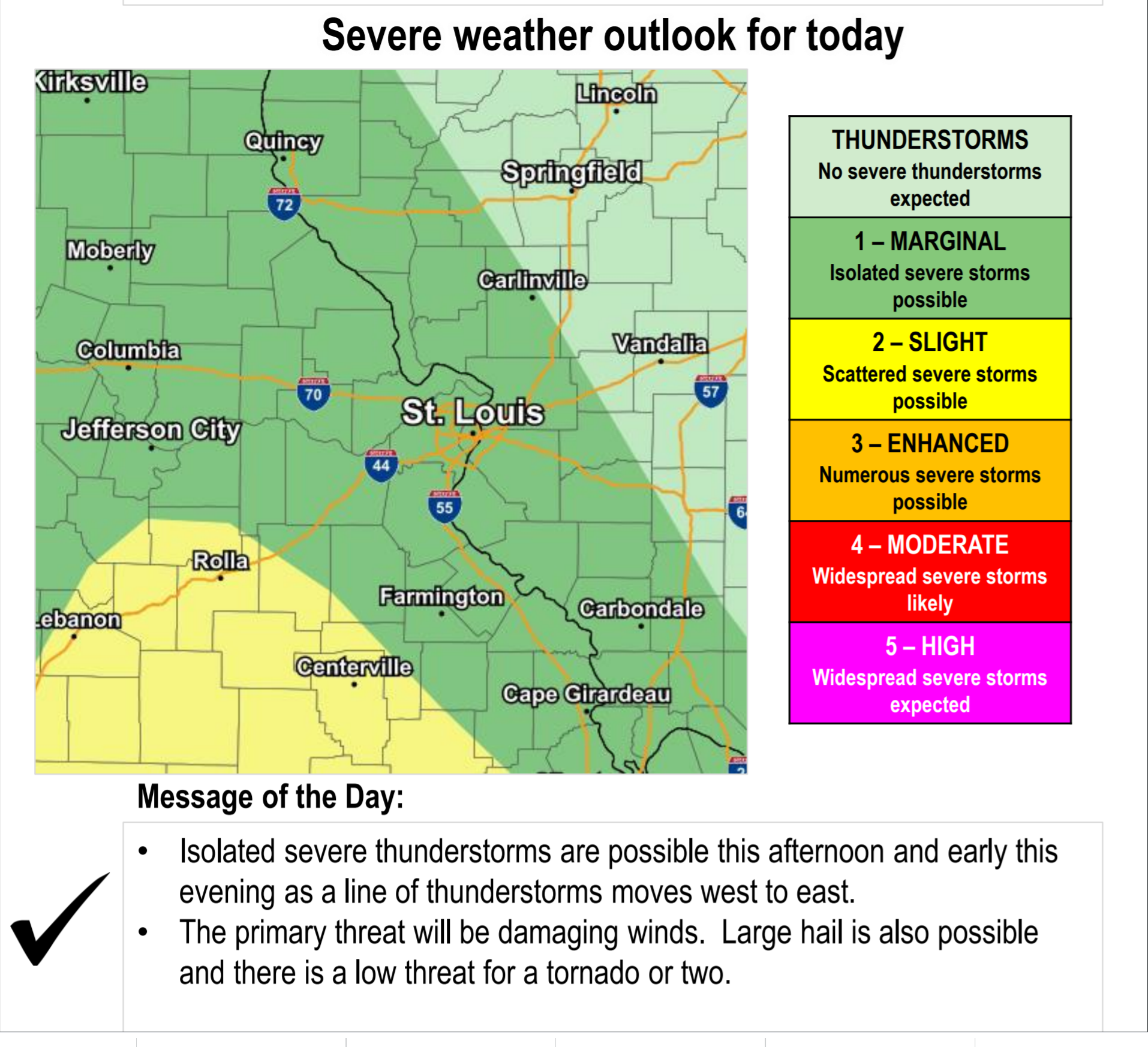
Today’s outlook (below).
Light green is where thunderstorms may occur but should be below severe levels.
Dark green is a level one risk. Yellow is a level two risk. Orange is a level three (enhanced) risk. Red is a level four (moderate) risk. Pink is a level five (high) risk.
One is the lowest risk. Five is the highest risk.
A severe storm is one that produces 58 mph wind or higher, quarter size hail, and/or a tornado.
The tan states are simply a region that SPC outlined on this particular map. Just ignore that.

The black outline is our local area.

.
Tomorrow’s severe weather outlook.

.

.
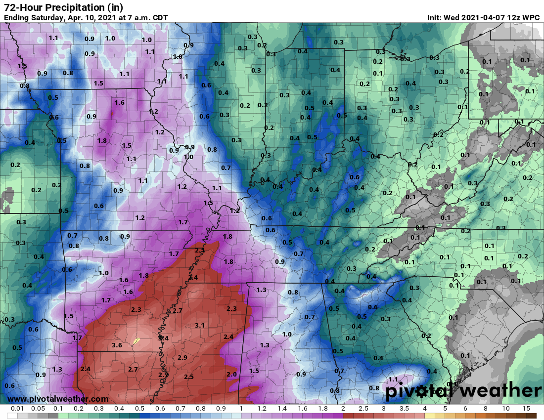
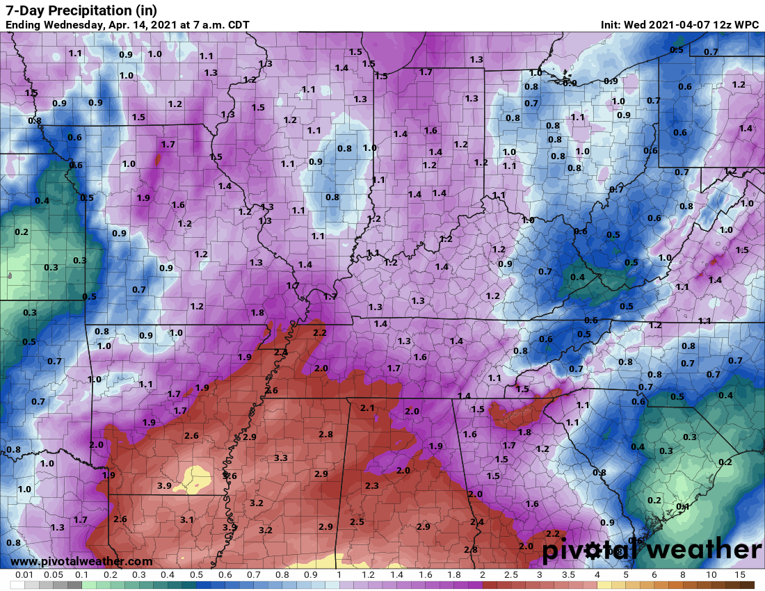
The images below are from the WPC. Their totals are a bit lower than our current forecast. I wanted to show you the comparison.
24-hour precipitation outlook.
.
 .
.
48-hour precipitation outlook.
.
.
72-hour precipitation outlook.
.
.
![]()
![]()

![]()
.Weather advice:
A few of the thunderstorms this afternoon and evening could be severe. The primary concern will be across southeast Missouri. The risk is lower as you move eastward.
.
Weather Discussion
-
- Warm and breezy today with increasing shower/thunderstorm chances.
- Locally intense storms this afternoon and evening.
- Thunderstorms Friday afternoon and night. Ending Saturday morning. Some could be intense.
.
Several rounds of showers and thunderstorms will occur over the next couple of days.
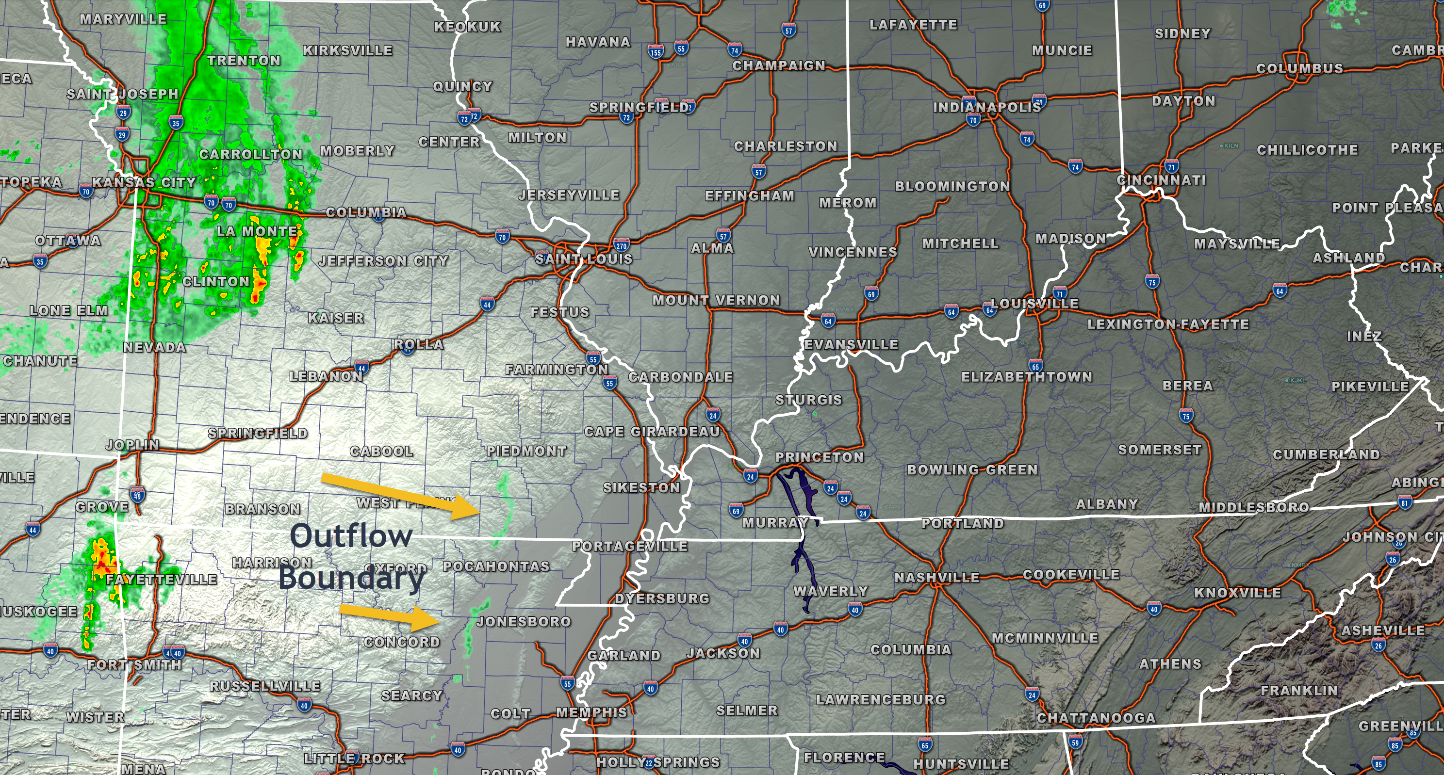
Our first system is already bring heavy thunderstorms to western Missouri this morning.
You can see that on this static radar image from 6 am.
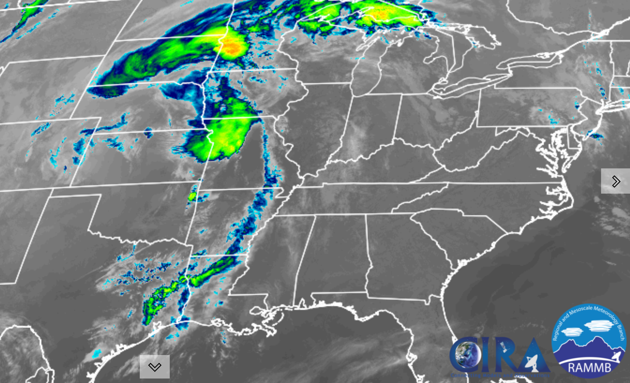
There is a little outflow boundary moving across southern Missouri and Arkansas. That boundary may become the focus of some showers and thunderstorms over southern Illinois and western Kentucky by late morning into mid-afternoon.
Models don’t agree on this portion of the forecast.
I do believe we will see at least a few showers/storms develop ahead of the main band.
You can also see that boundary on satellite.
.
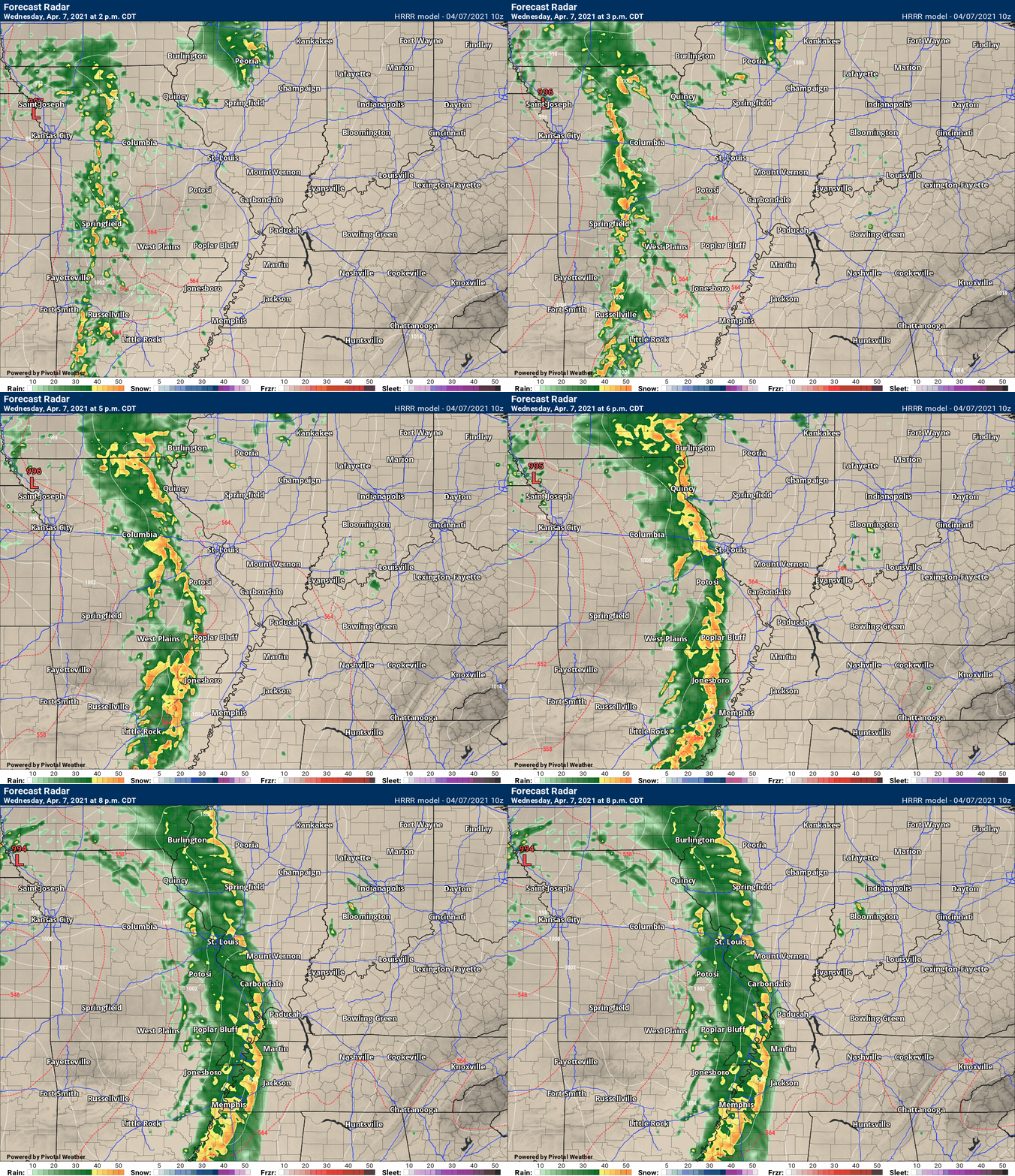
The bulk of the shower and thunderstorm activity will form this afternoon and evening.
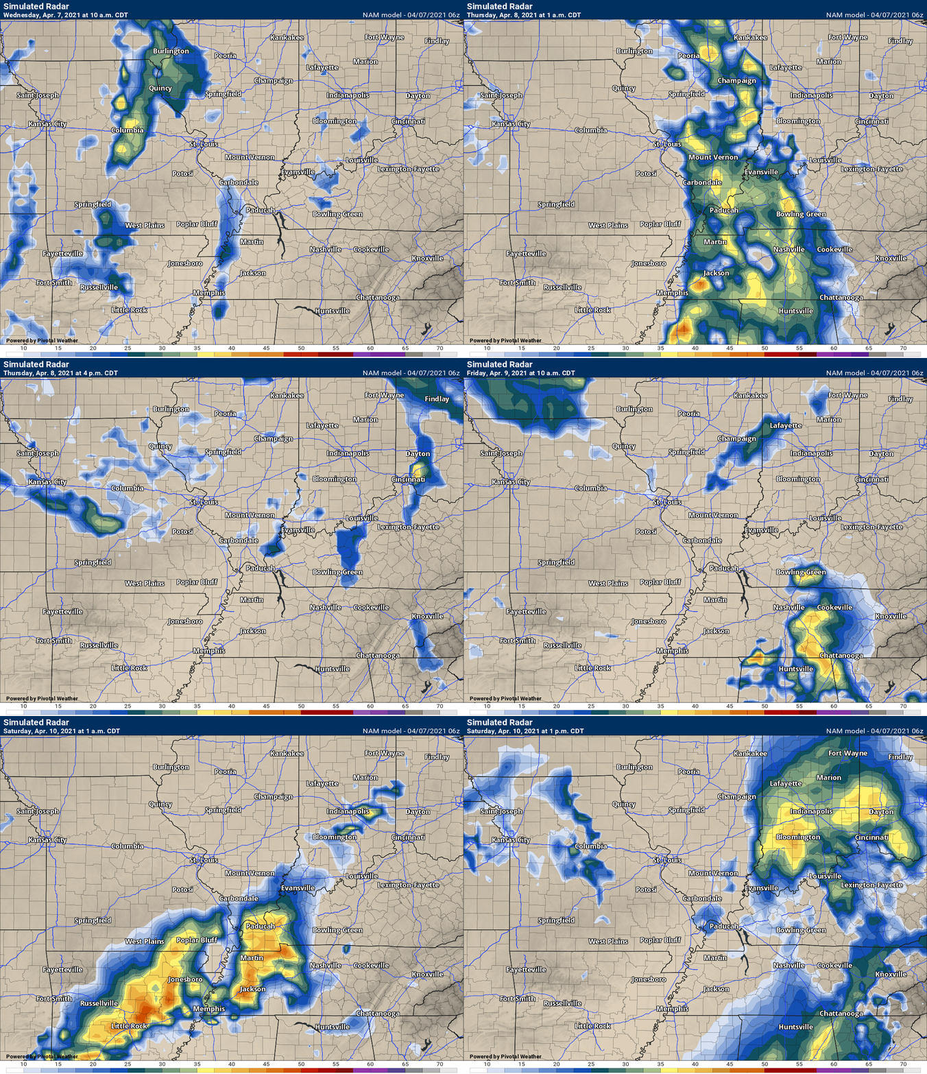
See the future-cast radars and how they portray this.
A line of showers and thunderstorms will form over southeast Missouri and Arkansas by early afternoon.
This activity will spread eastward, with time.
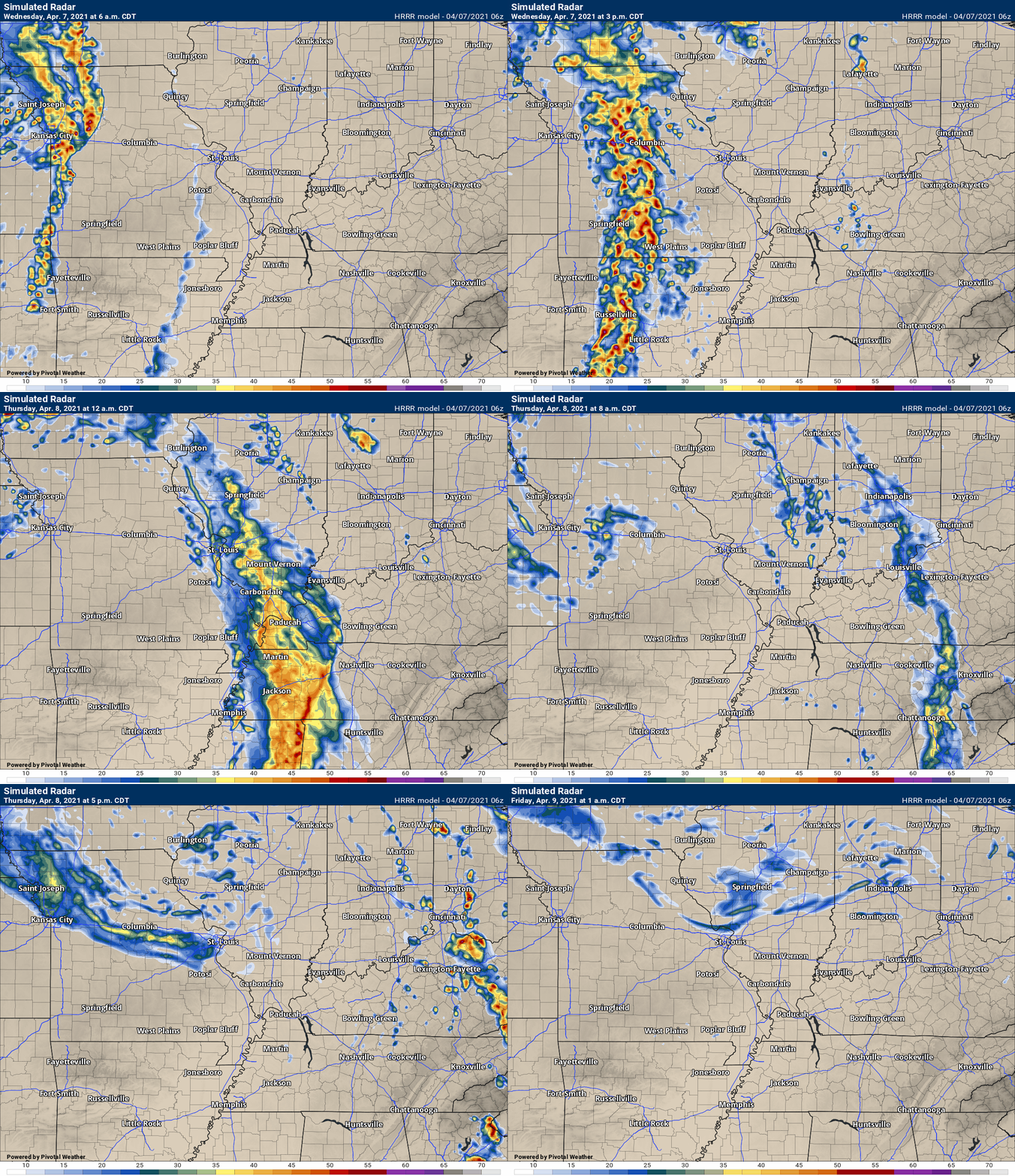
The Hrrr model shows it well. See the longer animations further down in the blog.
.
A few of the thunderstorms could become intense/severe by this afternoon.
A couple of the NWS offices have put out graphics.
The St Louis, Missouri, NWS, put this graphic out. The yellow zone is a bit higher risk than the dark green zone.
.
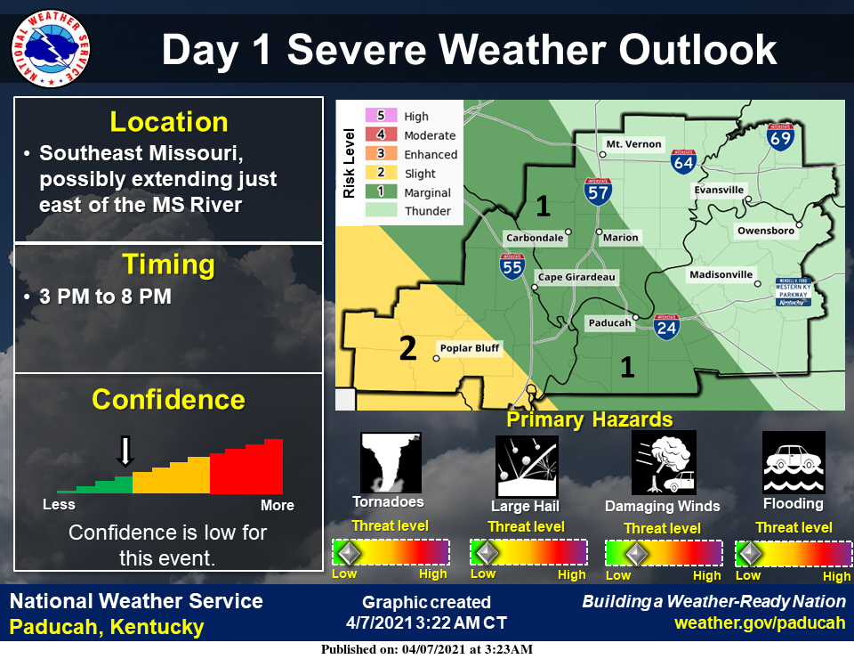
Here is the graphic the Paducah, Kentucky, NWS, put on their website.
Again, the dark green is a lesser risk than the yellow zone.
I would not get too caught up in the color schemes.
The bottom line is there is at least a chance of a few severe thunderstorms over mainly southeast Missouri later today.
The risk becomes lower (but not zero) as you travel further east.
This is not the best setup for widespread severe weather. We are missing some ingredients for that to happen.
Keep in mind, it only takes one severe weather report to cause headaches.
.
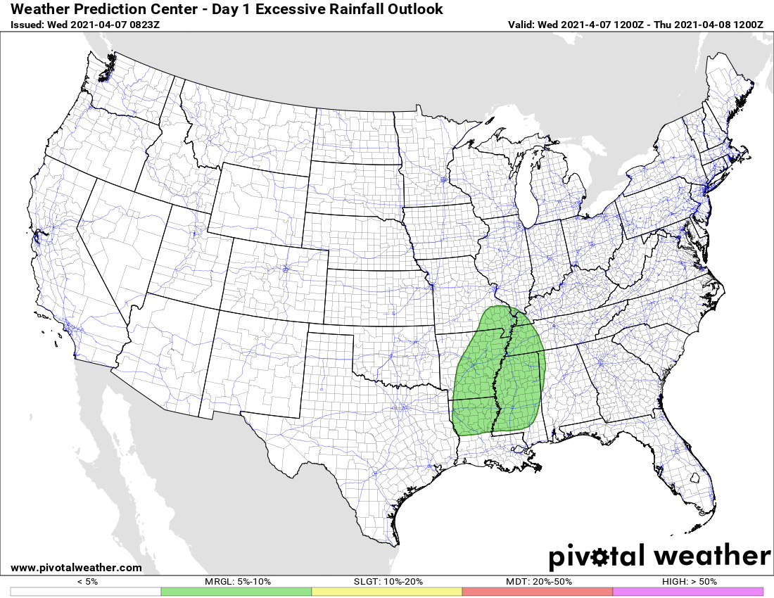
There is a low-end risk of excessive rainfall. Locally heavy rain could cause ditches and commonly flooded roadways to flood.
.
Let’s look at rainfall totals. As always, they will vary depending on the placement of thunderstorms.
A widespread 0.40 to 0.80″ of rain is anticipated. Then, I can’t rule out pockets of higher totals.
You can see the WPC/NOAA rain totals forecast above (or here)
.
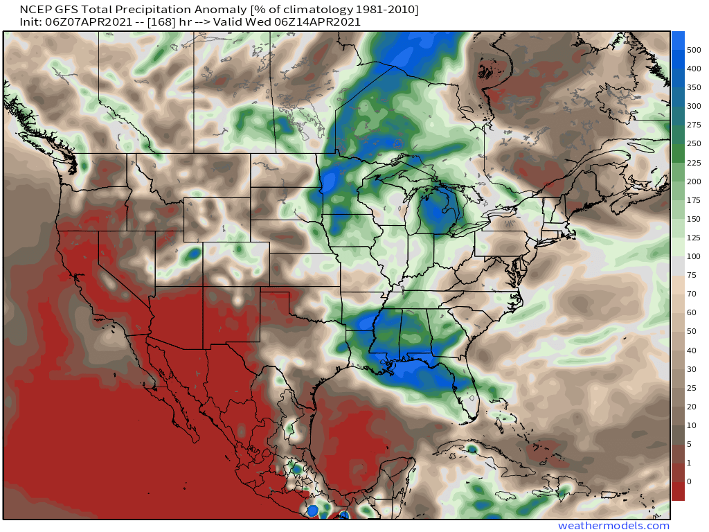
The, through day seven
.
The cold front will push eastward tomorrow night into Thursday morning.
Thursday into Friday will likely be “mostly” dry.
Another low will form Friday night and Saturday in the Ohio Valley. A few showers and thunderstorms will be possible Friday night into Saturday night.
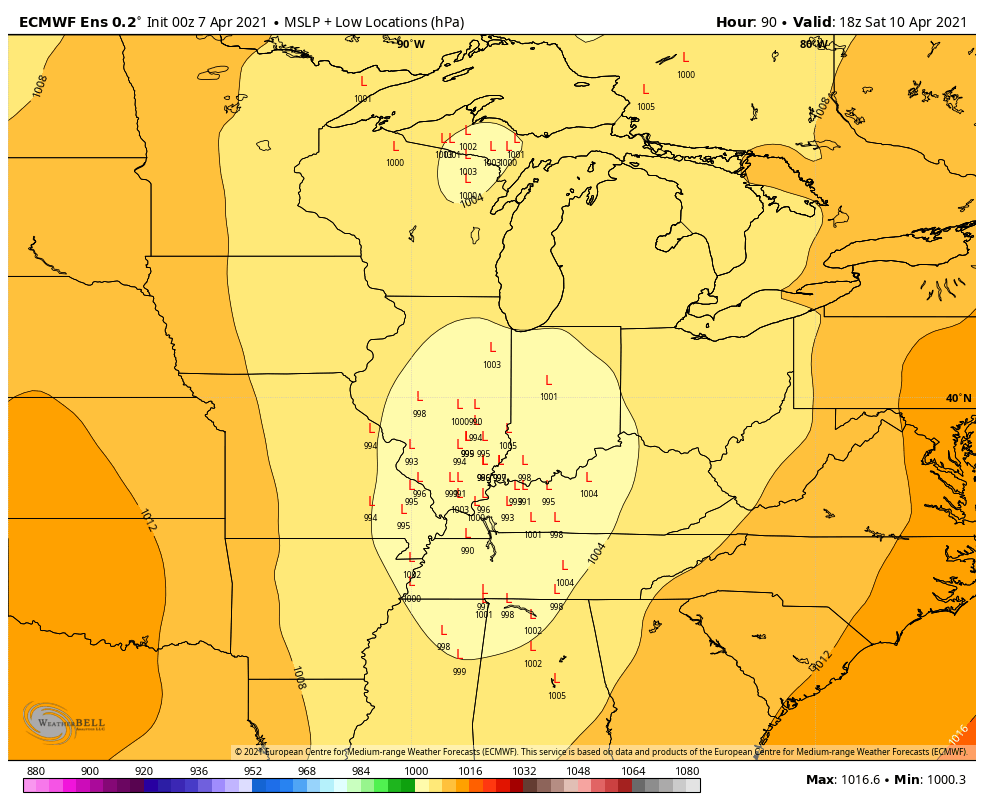
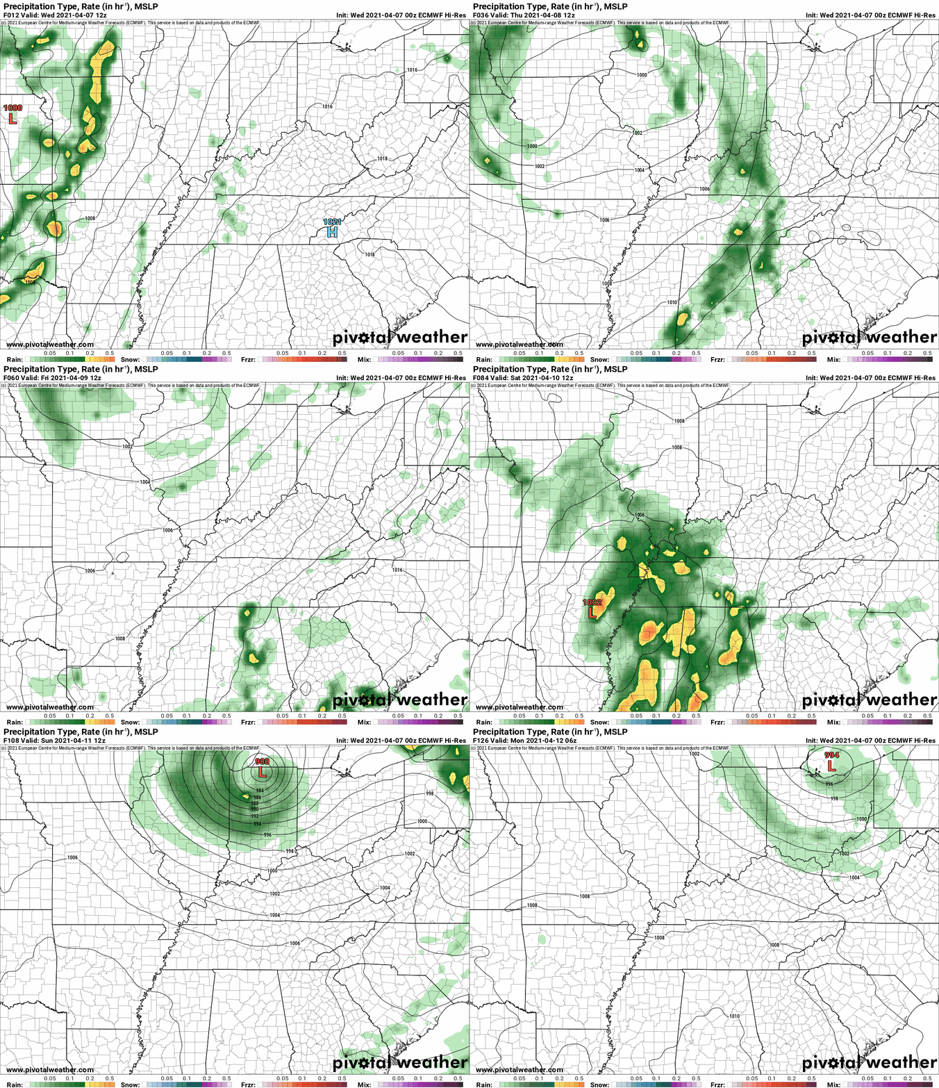
Model guidance is not in agreement on the strength of the Friday night/Saturday system. The EC is a stronger area of low pressure. This is a concern, because it could mean heavier rain and stronger thunderstorms.
Let’s keep an eye on model trends Friday night into Saturday night.
The system will depart Sunday and Monday.
Models do show another weak cold front Monday night and Tuesday. I will keep an eye on shower chances with it. For now, moisture return appears low.
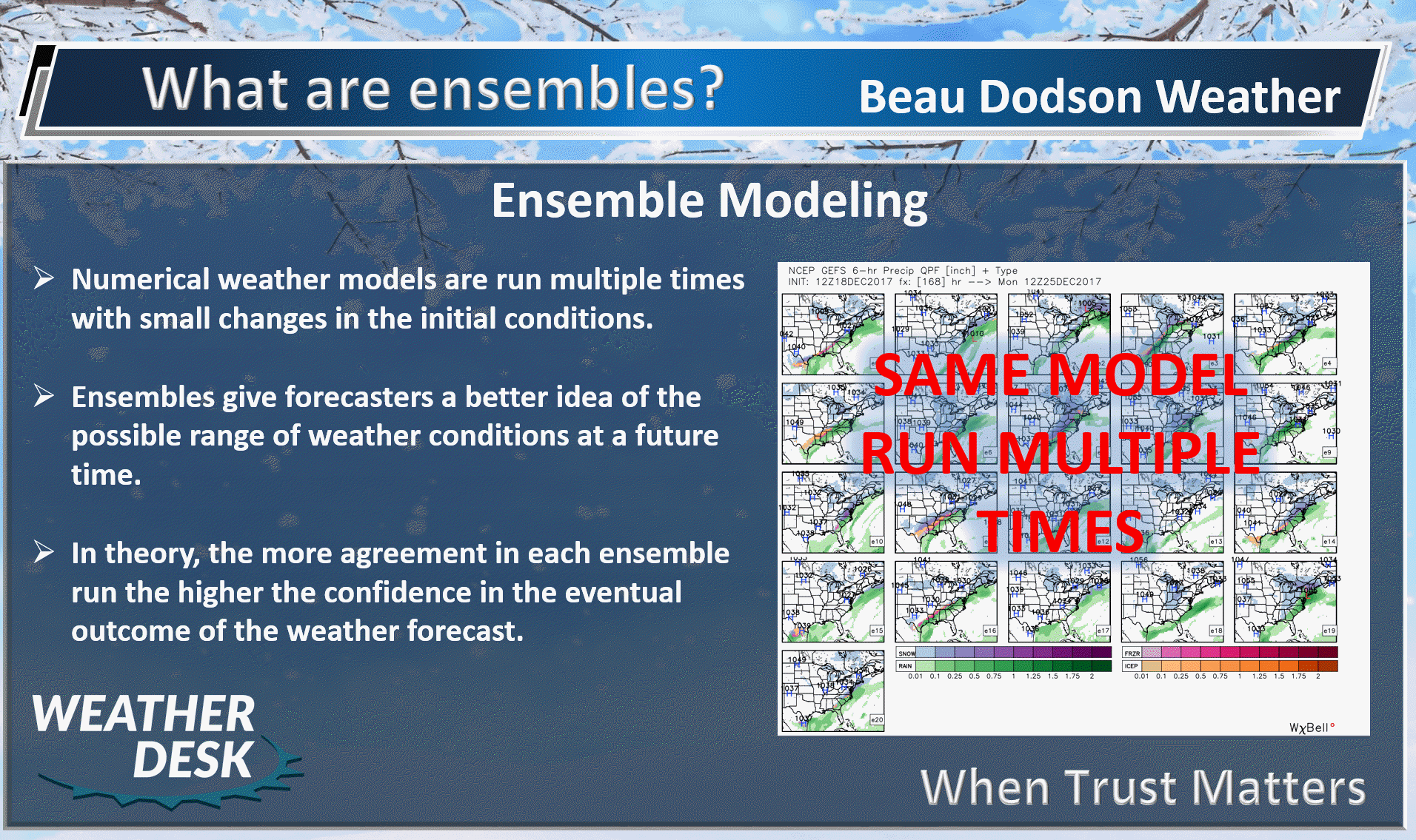
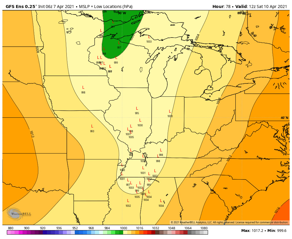
Let me show you some ensemble data.
.
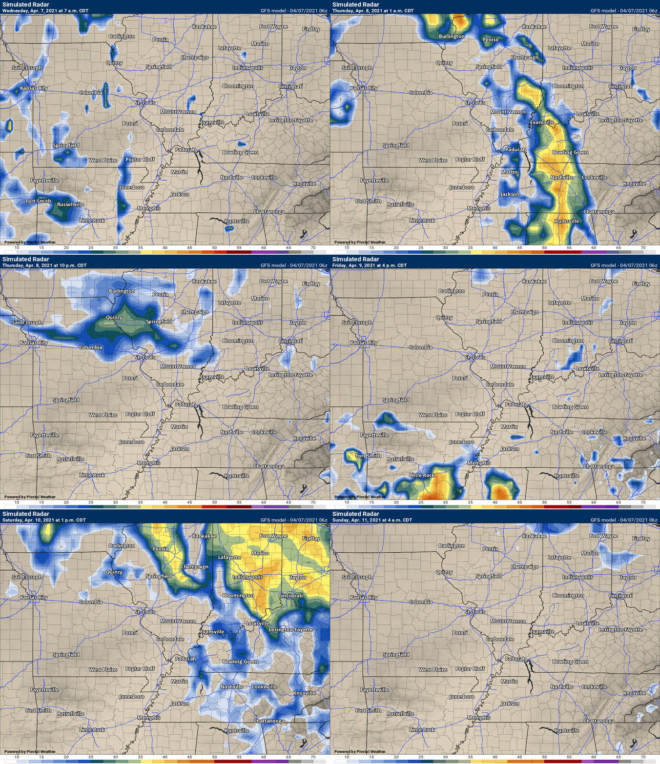
The GFS model is a weaker low Saturday morning.
.
The EC model, on the other hand, is stronger. Deeper. Pulls more moisture northward vs the GFS model.
The EC model might even suggest a risk of severe weather in the region. Again, this is Friday night into Saturday.
.


Click here if you would like to return to the top of the page.
Again, as a reminder, these are models. They are never 100% accurate. Take the general idea from them.
What should I take from these?
- The general idea and not specifics. Models usually do well with the generalities.
- The time-stamp is located in the upper left corner.
- The EC European weather model is in Zulu time.
.
What am I looking at?
You are looking at different models. Meteorologists use many different models to forecast the weather. All models are wrong. Some are more wrong than others. Meteorologists have to make a forecast based on the guidance/models.
I show you these so you can see what the different models are showing as far as precipitation. If most of the models agree, then the confidence in the final weather forecast increases.
You can see my final forecast at the top of the page.
.
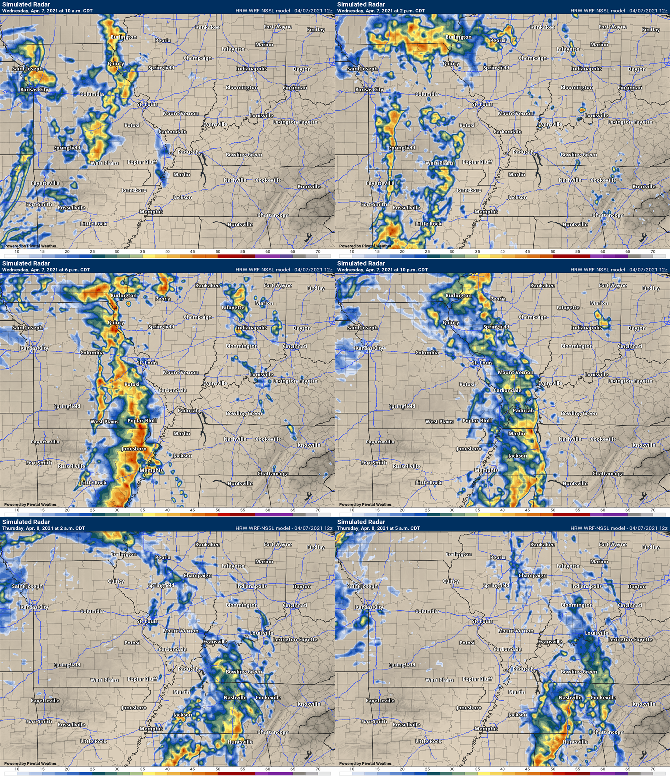
This animation is the Storm Prediction Center WRF model.
This animation shows you what radar might look like as the next system pulls through the region. It is a future-cast radar.
Time-stamp upper left. Click the animation to enlarge it.
.
This animation is the Hrrr short-range model.
.
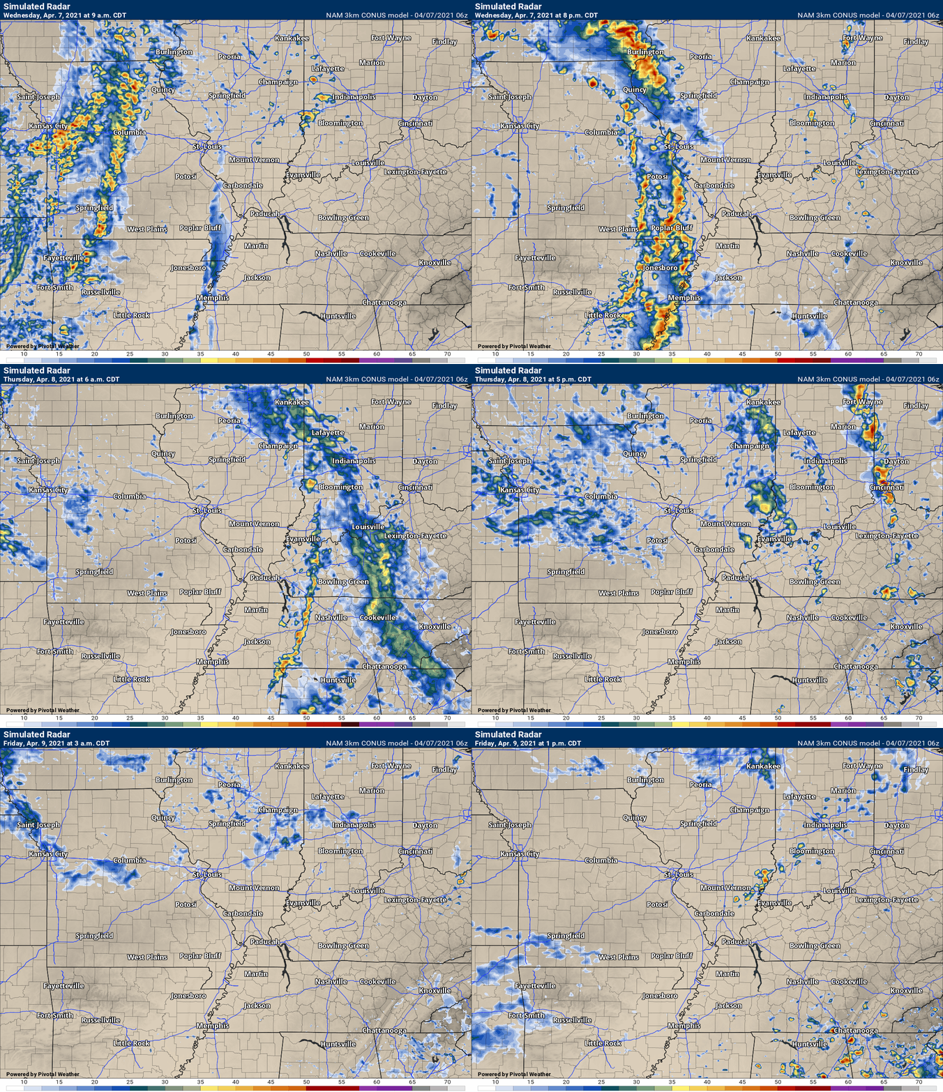
.This animation is the 3K NAM American Model.
This animation shows you what radar might look like as the next system pulls through the region. It is a future-cast radar.
Time-stamp upper left. Click the animation to enlarge it.
This next animation is the lower-resolution NAM American Model.
This animation shows you what radar might look like as the system pulls through the region. It is a future-cast radar.
Time-stamp upper left. Click the animation to enlarge it.
.
This next animation is the GFS American Model.
This animation shows you what radar might look like as the system pulls through the region. It is a future-cast radar.
Time-stamp upper left. Click the animation to enlarge it.
.
This next animation is the EC European Weather model.
This animation shows you what radar might look like as the system pulls through the region. It is a future-cast radar.
Time-stamp upper left. Click the animation to enlarge it.
.
![]()
.
.
Click here if you would like to return to the top of the page.
.
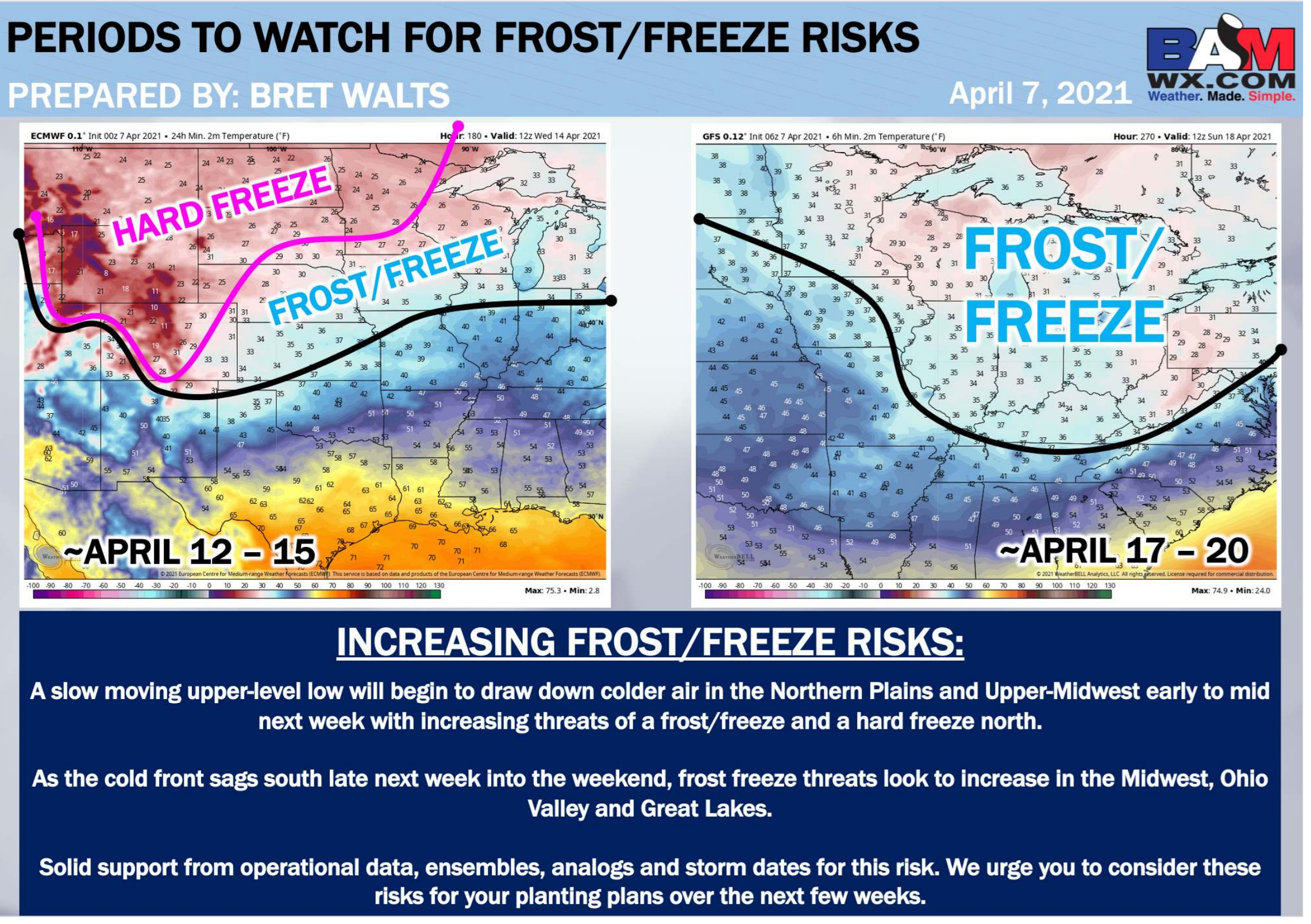
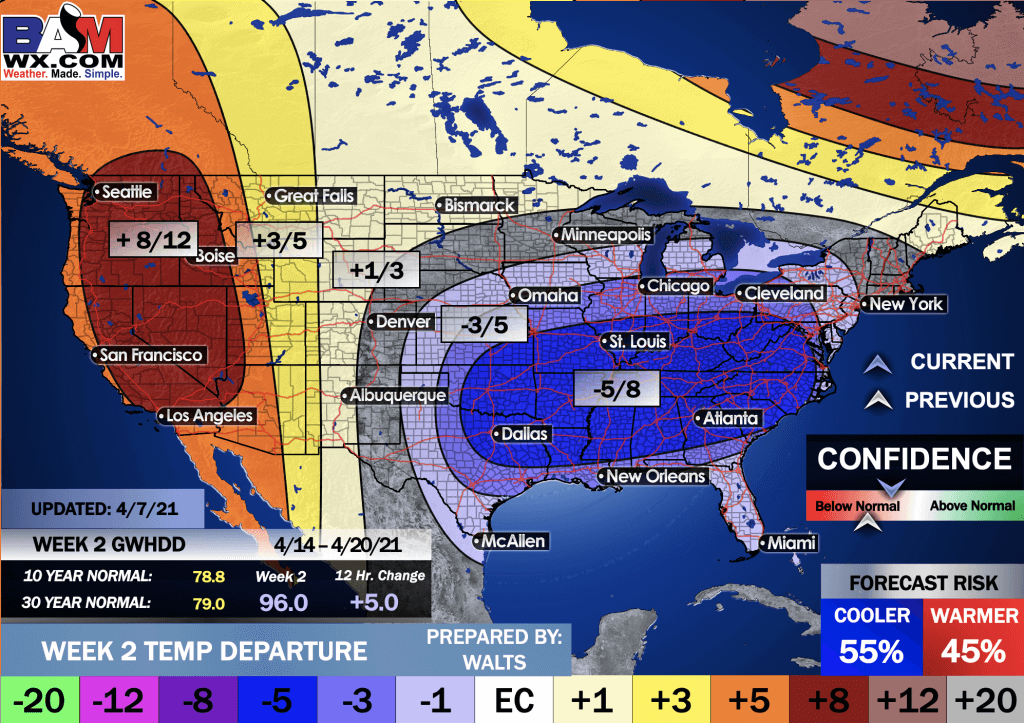
Average high temperatures for this time of the year are around 66 degrees.
Average low temperatures for this time of the year are around 46 degrees.
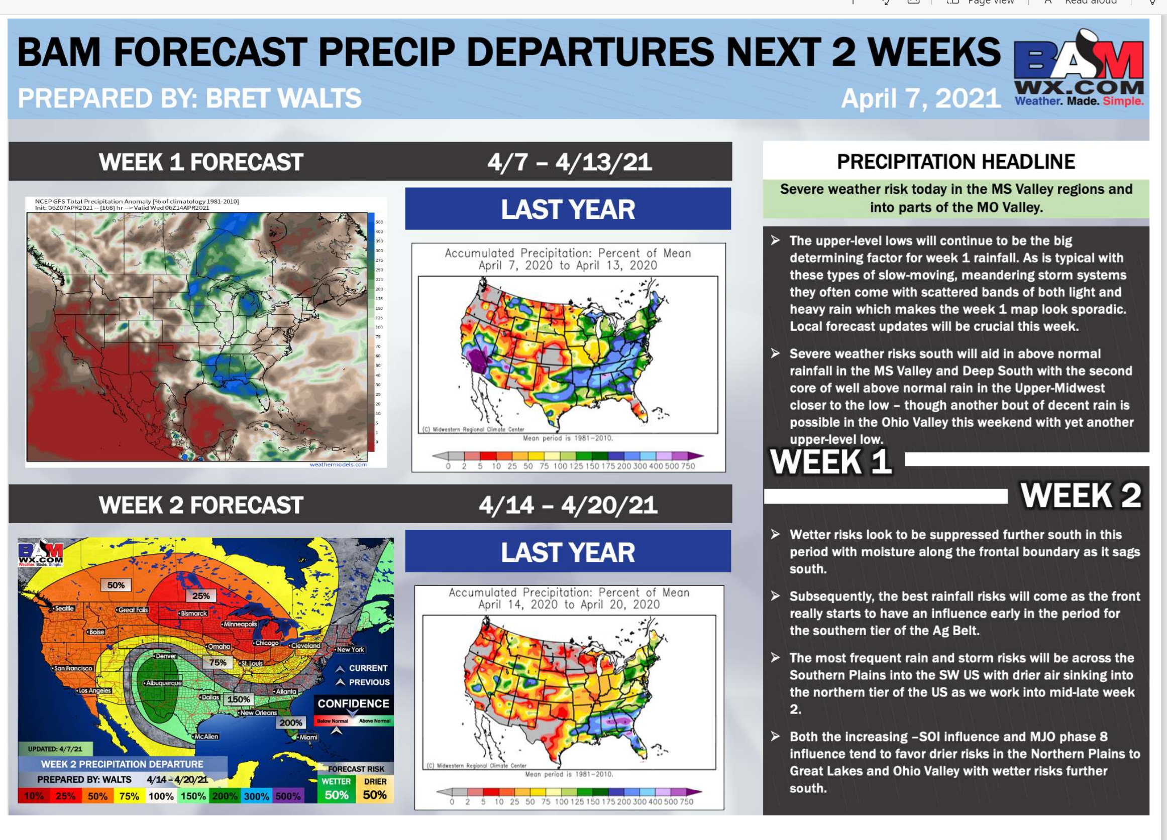
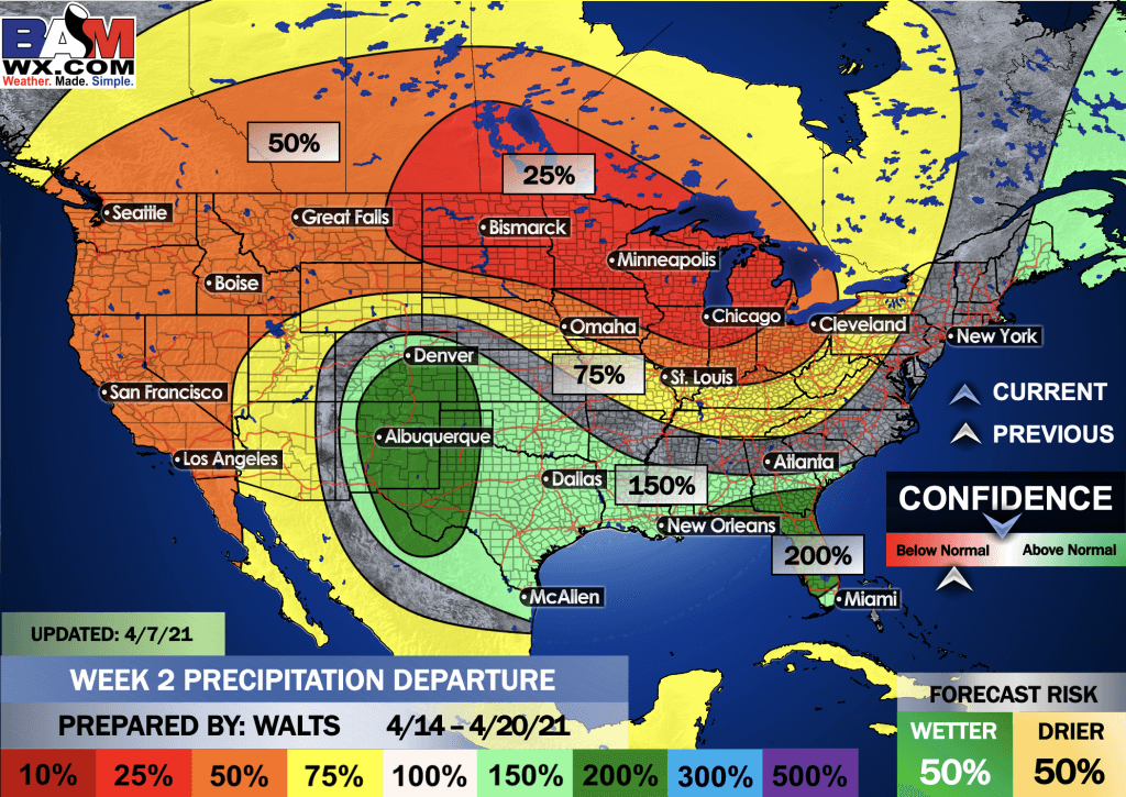
Average precipitation during this time period ranges from 0.70″ to 1.00″
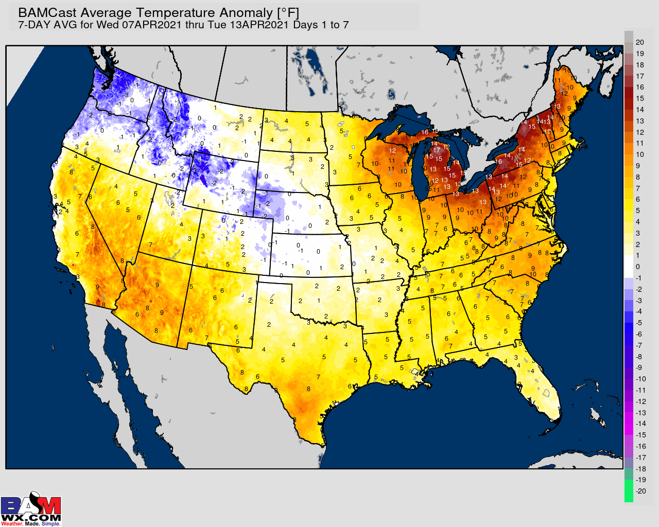
Yellow and orange colors are above average temperatures. Red is much above average. Light blue and blue are below-average temperatures. Green to purple colors represents much below-average temperatures.

Average low temperatures for this time of the year are around 47 degrees
Average precipitation during this time period ranges from 0.70″ to 1.00″
.
This outlook covers April 13th through April 19th
Click on the image to expand it.
.
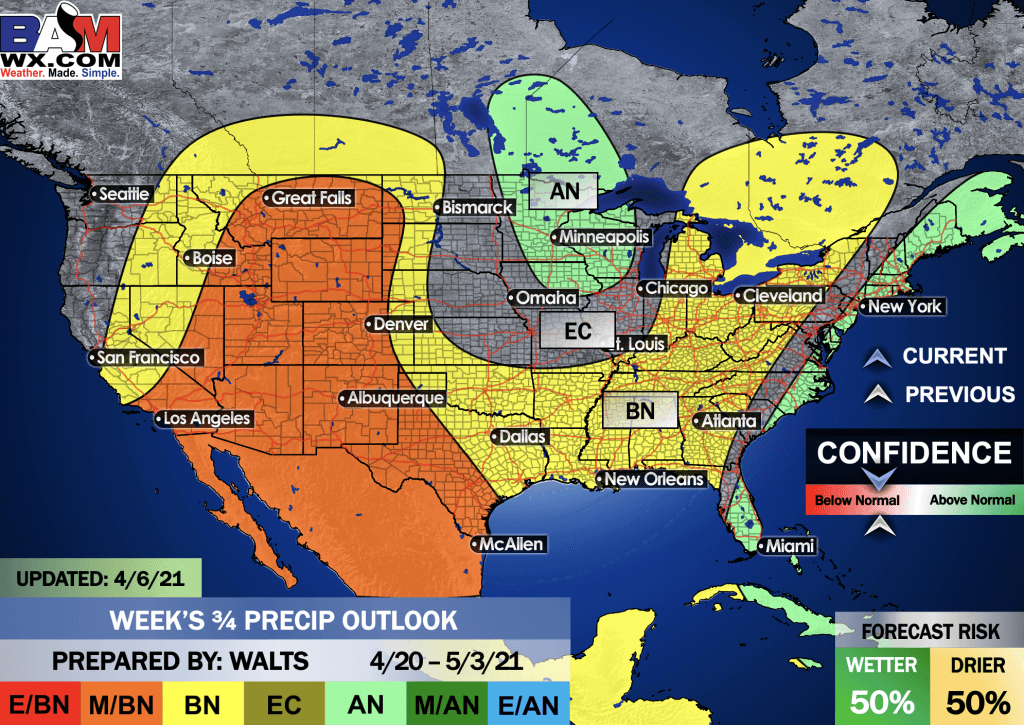
The precipitation forecast is PERCENT OF AVERAGE. Brown is below average. Green is above average. Blue is much above average.
.

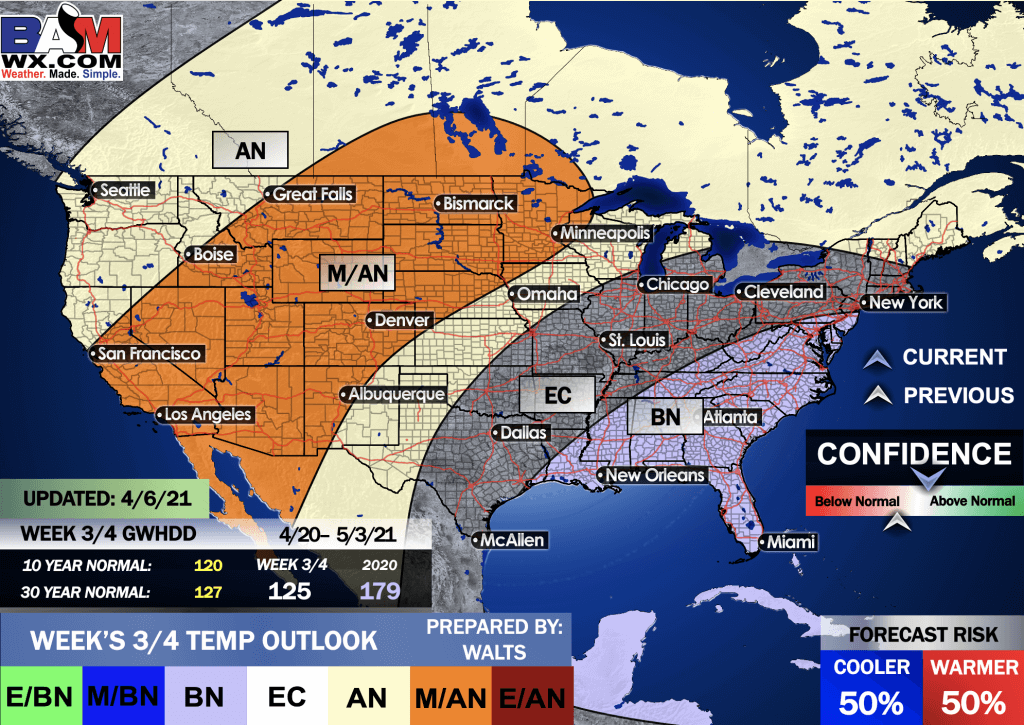
EC = Equal chances of above or below average
BN= Below average
M/BN = Much below average
AN = Above average
M/AN = Much above average
E/AN = Extremely above average
Average low temperatures for this time of the year are around 50 degrees
Average precipitation during this time period ranges from 1.60″ to 2.20″
This outlook covers April 13th through April 26th
.
Precipitation outlook
LONG RANGE DISCUSSION
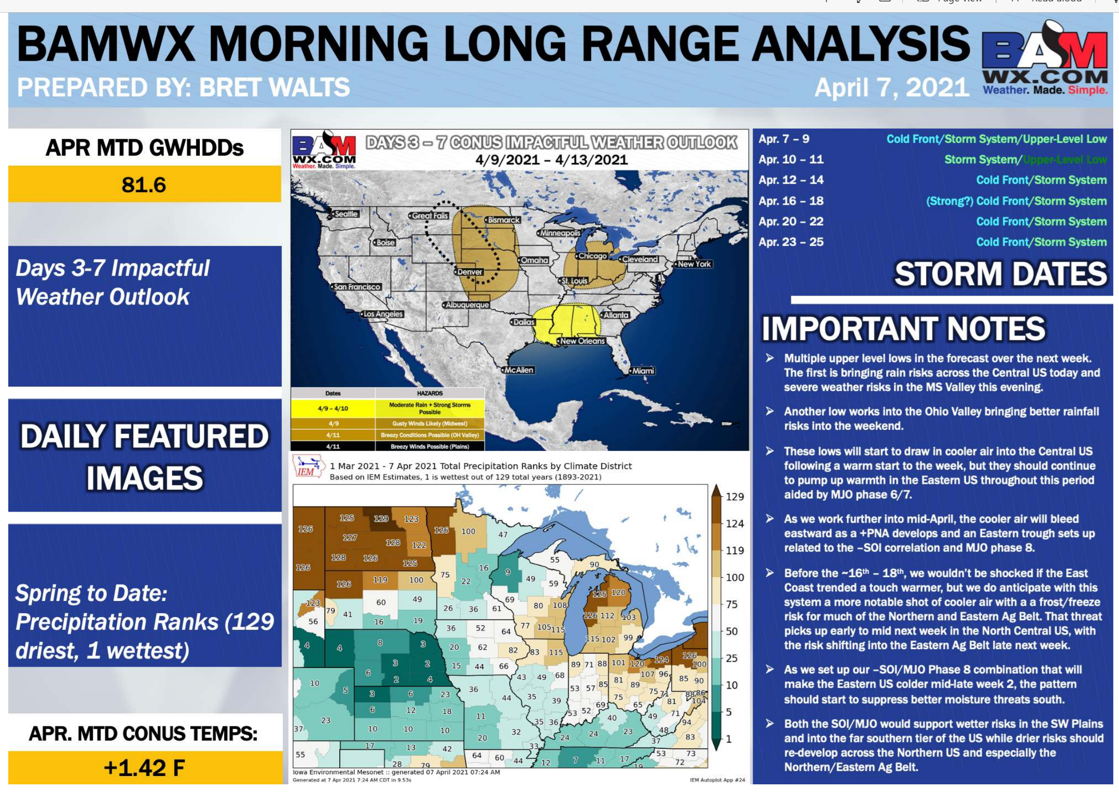
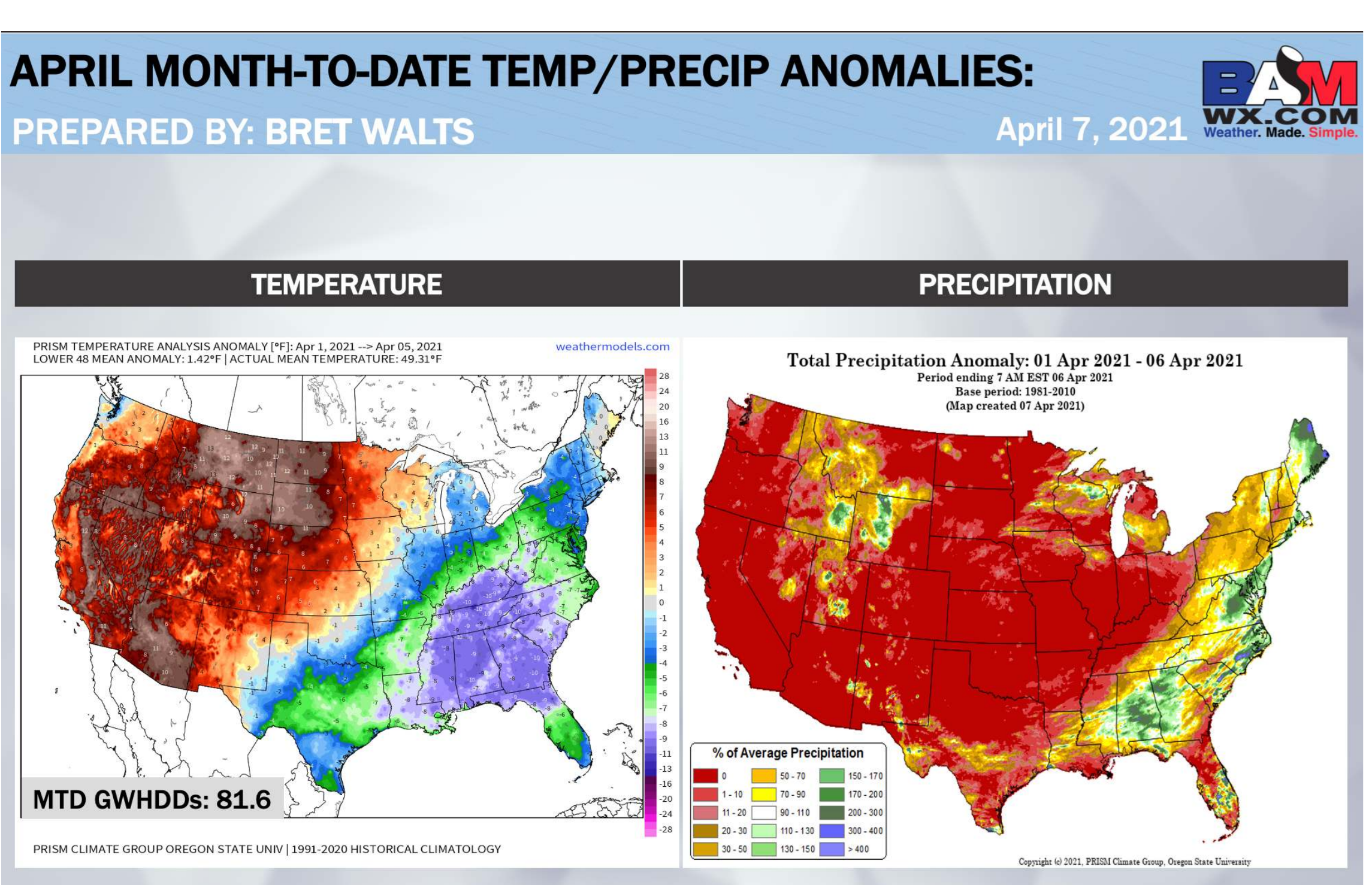
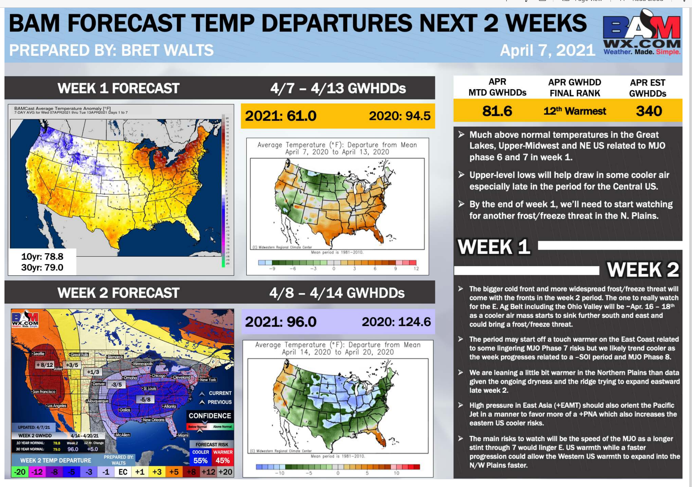
Key Points: This was written by the BAMwx team. I don’t edit it.
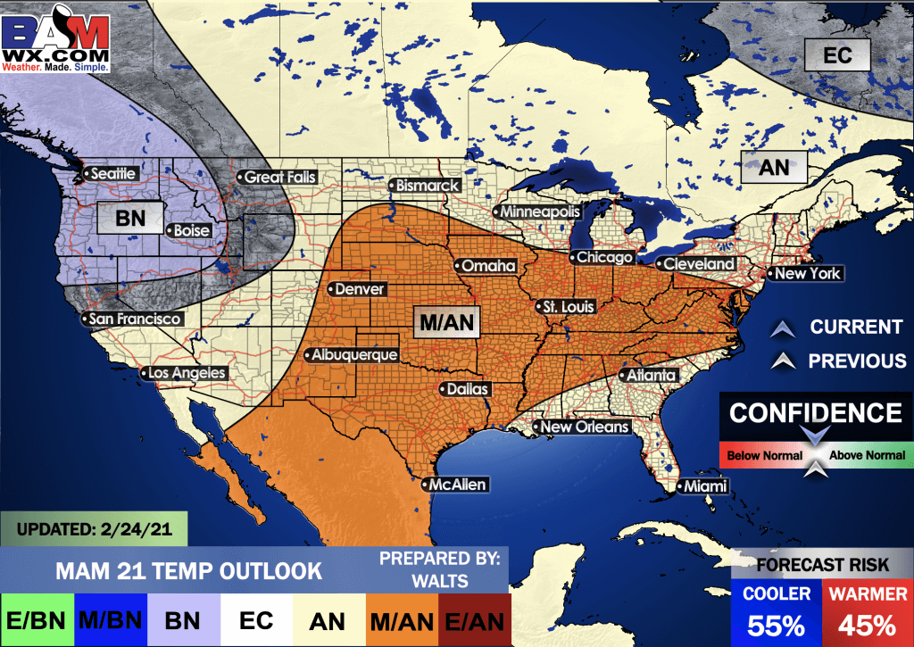
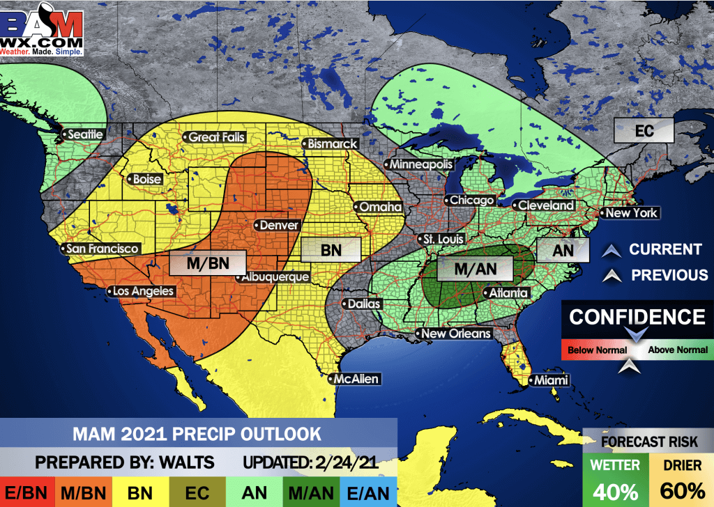
Spring Outlook
E/BN extremely below normal.
M/BN is much below normal
EC equal chances
AN above normal
M/AN much above normal
E/AN extremely above normal.
March, April, and May Temperature Outlook
.
March, April, and May Precipitation Outlook
.
E/BN extremely below normal.
M/BN is much below normal
EC equal chances
AN above normal
M/AN much above normal
E/AN extremely above normal.
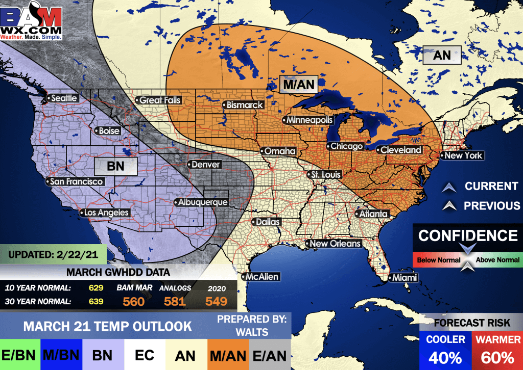
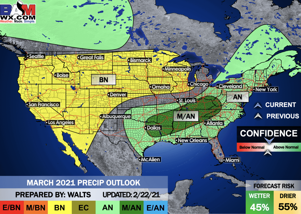
And the preliminary March outlooks
Temperature departures
Precipitation
.
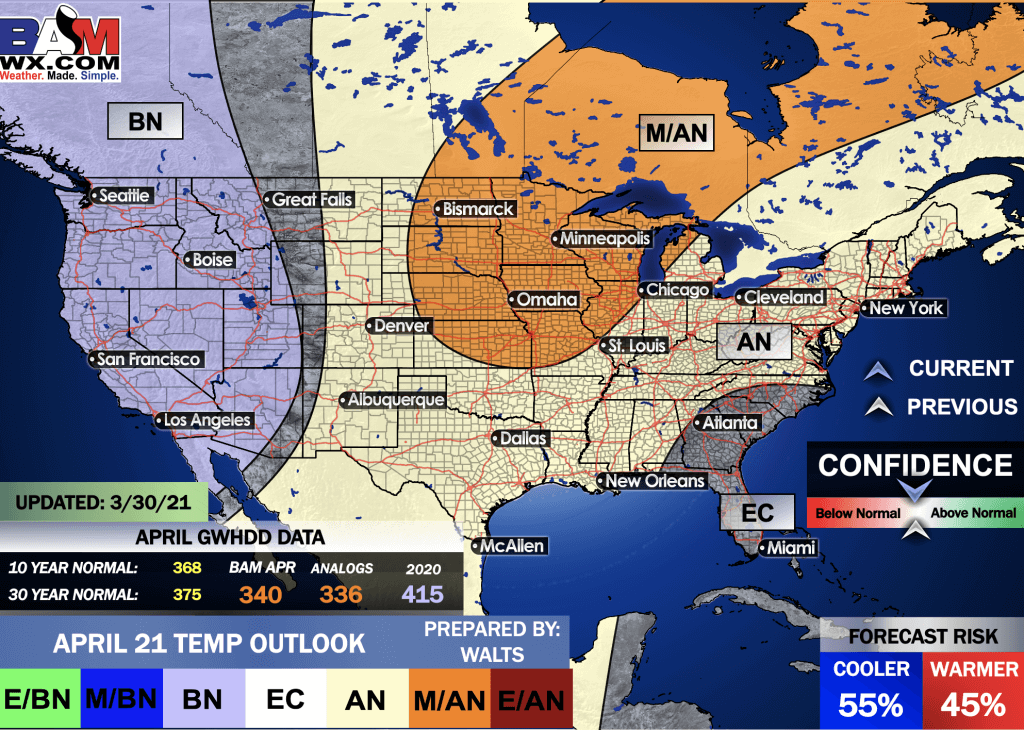
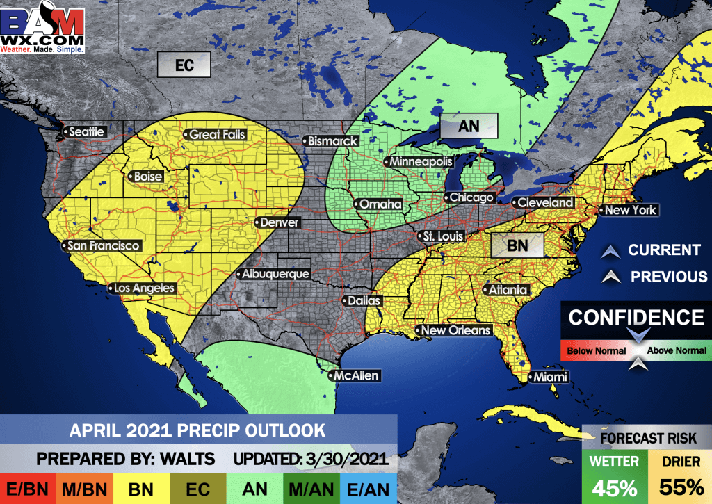
And the preliminary April outlooks
E/BN extremely below normal.
M/BN is much below normal
EC equal chances
AN above normal
M/AN much above normal
E/AN extremely above normal.
Temperature departures
Precipitation
.
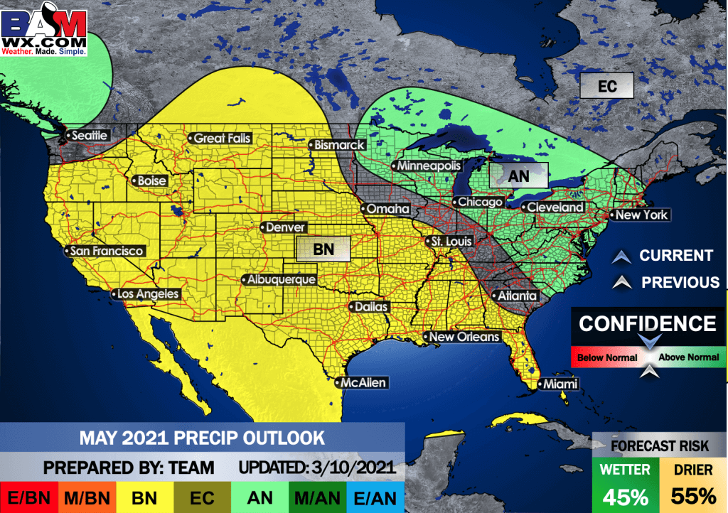
And the preliminary May outlooks
E/BN extremely below normal.
M/BN is much below normal
EC equal chances
AN above normal
M/AN much above normal
E/AN extremely above normal.
Temperature departures
Precipitation
.
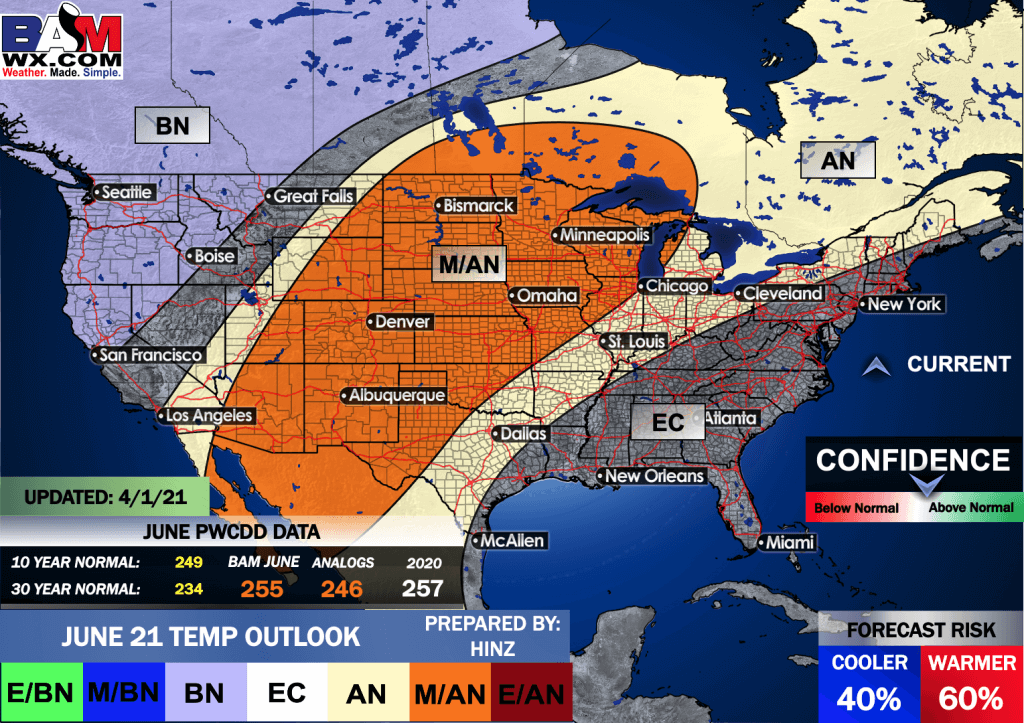
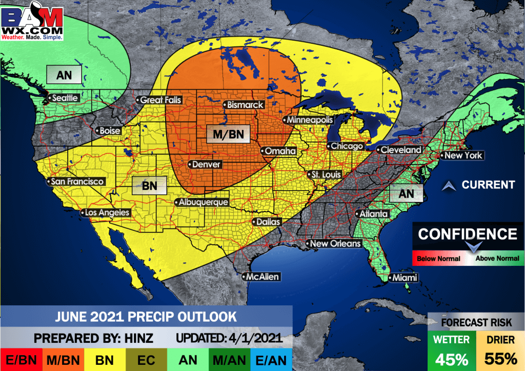
The preliminary June outlooks
E/BN extremely below normal.
M/BN is much below normal
EC equal chances
AN above normal
M/AN much above normal
E/AN extremely above normal.
Temperature departures
Precipitation Outlook
.
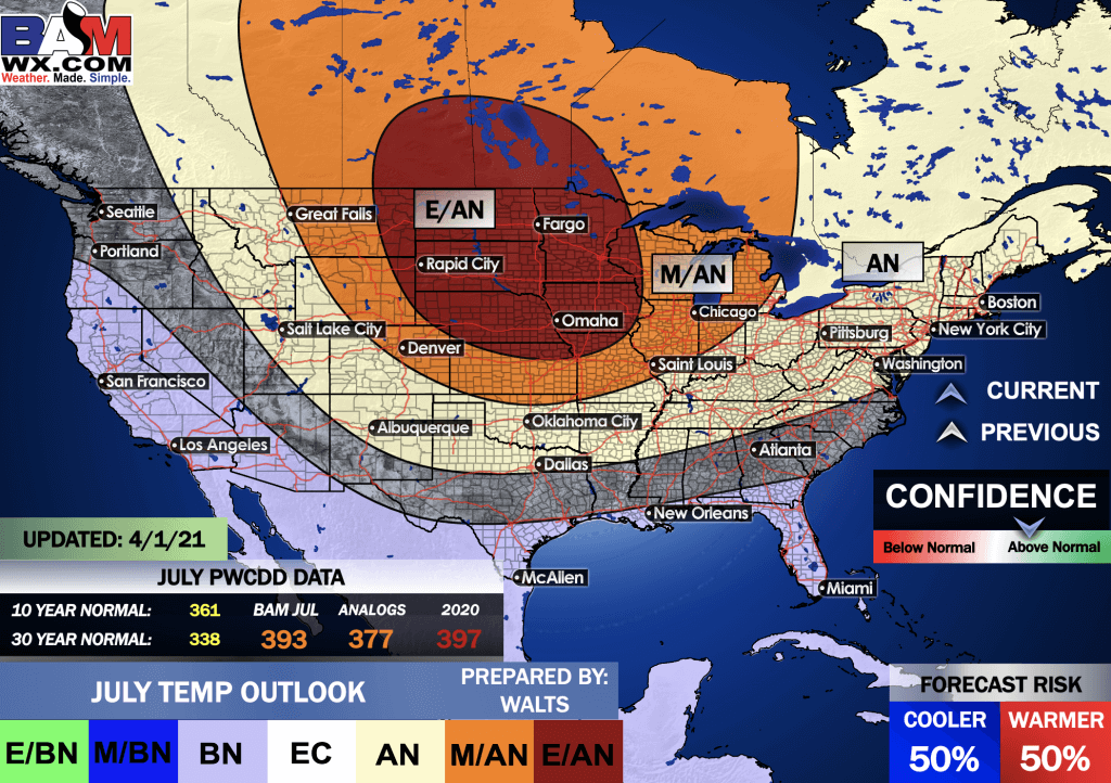
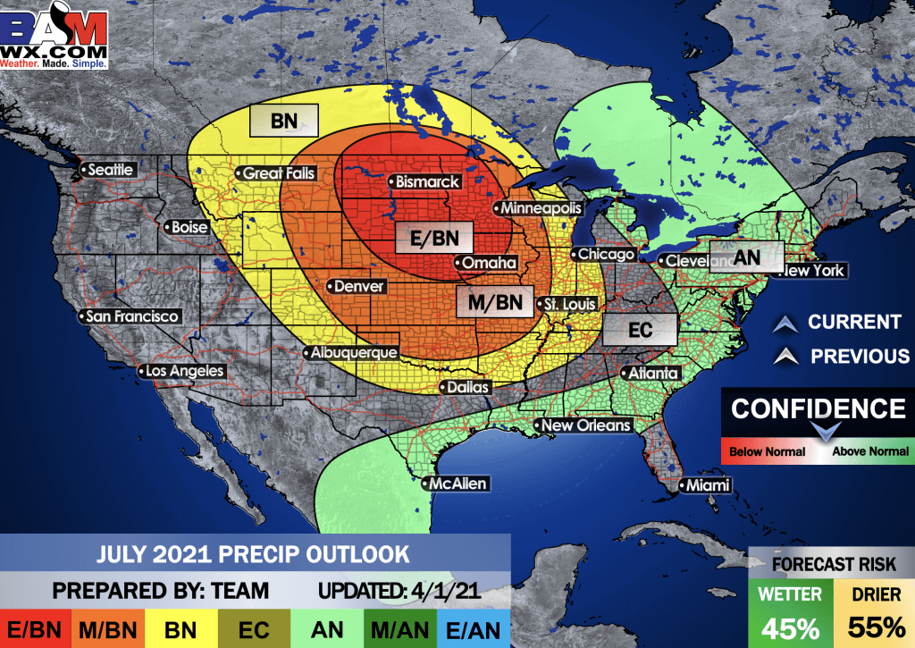
Preliminary outlooks
E/BN extremely below normal.
M/BN is much below normal
EC equal chances
AN above normal
M/AN much above normal
E/AN extremely above normal.
July Temperature Outlook
July Precipitation Outlook
.
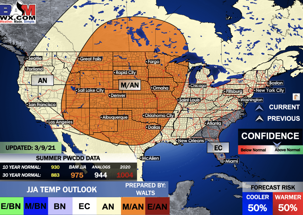
Summer Outlook
E/BN extremely below normal.
M/BN is much below normal
EC equal chances
AN above normal
M/AN much above normal
E/AN extremely above normal.
June, July, and August Temperature Outlook
.
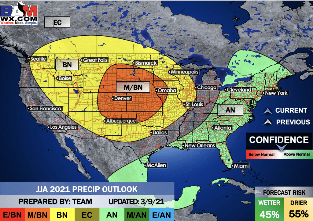
Precipitation Outlook
E/BN extremely below normal.
M/BN is much below normal
EC equal chances
AN above normal
M/AN much above normal
E/AN extremely above normal.
.
![]()

Great news! The videos are now found in your Weathertalk app and on the WeatherTalk website.
These are bonus videos for subscribers.
The app is for subscribers. Subscribe at www.weathertalk.com/welcome then go to your app store and search for WeatherTalk
Subscribers, PLEASE USE THE APP. ATT and Verizon are not reliable during severe weather. They are delaying text messages.
The app is under WeatherTalk in the app store.
Apple users click here
Android users click here
.

Radars and Lightning Data
Interactive-city-view radars. Clickable watches and warnings.
https://wtalk.co/B3XHASFZ
If the radar is not updating then try another one. If a radar does not appear to be refreshing then hit Ctrl F5. You may also try restarting your browser.
Backup radar site in case the above one is not working.
https://weathertalk.com/morani
Regional Radar
https://imagery.weathertalk.com/prx/RadarLoop.mp4
** NEW ** Zoom radar with chaser tracking abilities!
ZoomRadar
Lightning Data (zoom in and out of your local area)
https://wtalk.co/WJ3SN5UZ
Not working? Email me at beaudodson@usawx.com
National map of weather watches and warnings. Click here.
Storm Prediction Center. Click here.
Weather Prediction Center. Click here.
.

Live lightning data: Click here.
.

Interactive GOES R satellite. Track clouds. Click here.
GOES 16 slider tool. Click here.
College of Dupage satellites. Click here
.

Here are the latest local river stage forecast numbers Click Here.
Here are the latest lake stage forecast numbers for Kentucky Lake and Lake Barkley Click Here.
.
.
Find Beau on Facebook! Click the banner.








 .
.