
Click one of the links below to take you directly to that section
Do you have any suggestions or comments? Email me at beaudodson@usawx.com
.
.
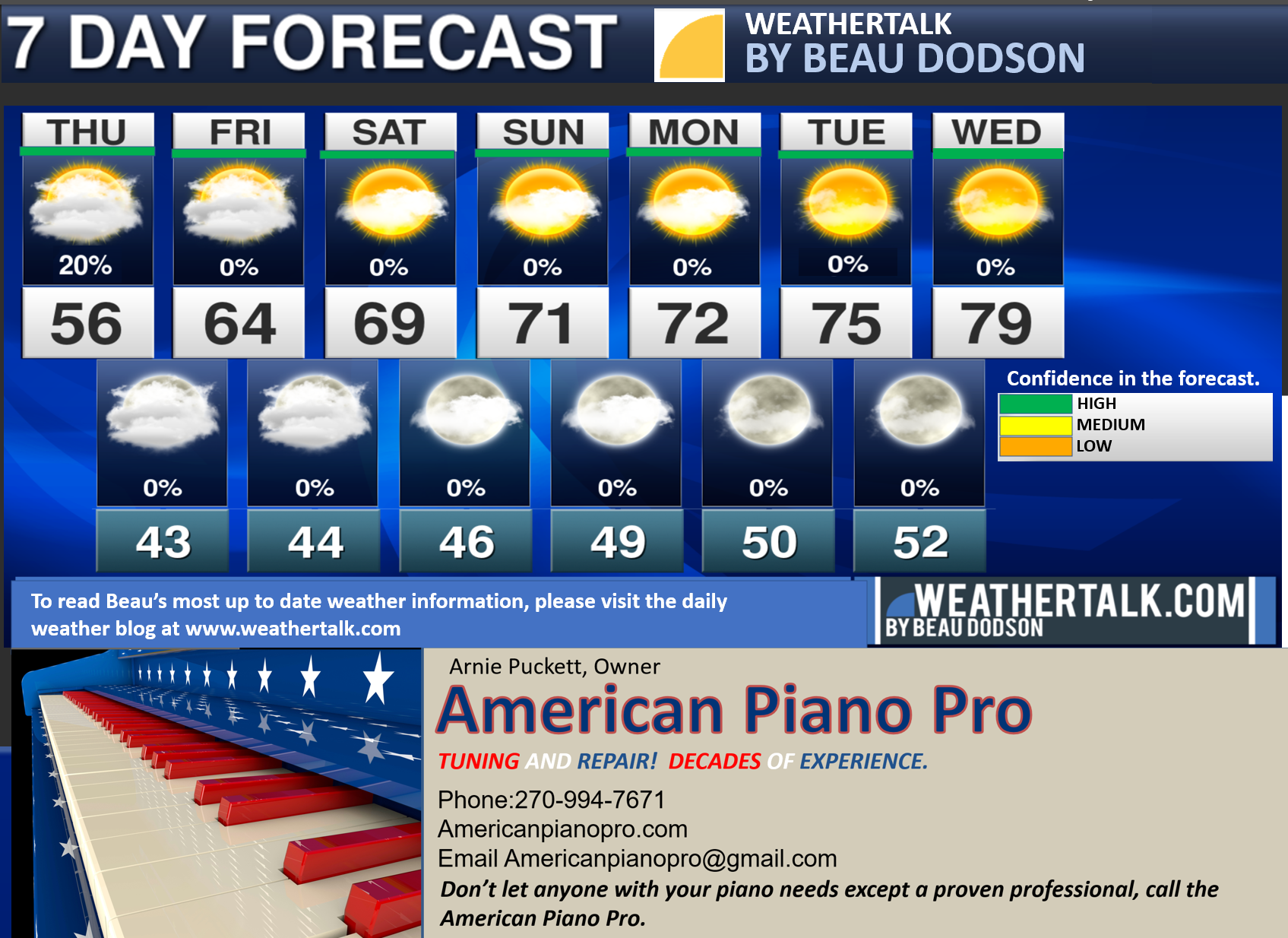
Seven-day forecast for southeast Missouri, southern Illinois, western Kentucky, and western Tennessee.
This is a BLEND for the region. Scroll down to see the region by region forecast.
THE FORECAST IS GOING TO VARY FROM LOCATION TO LOCATION. Scroll down to see the region by region forecast.
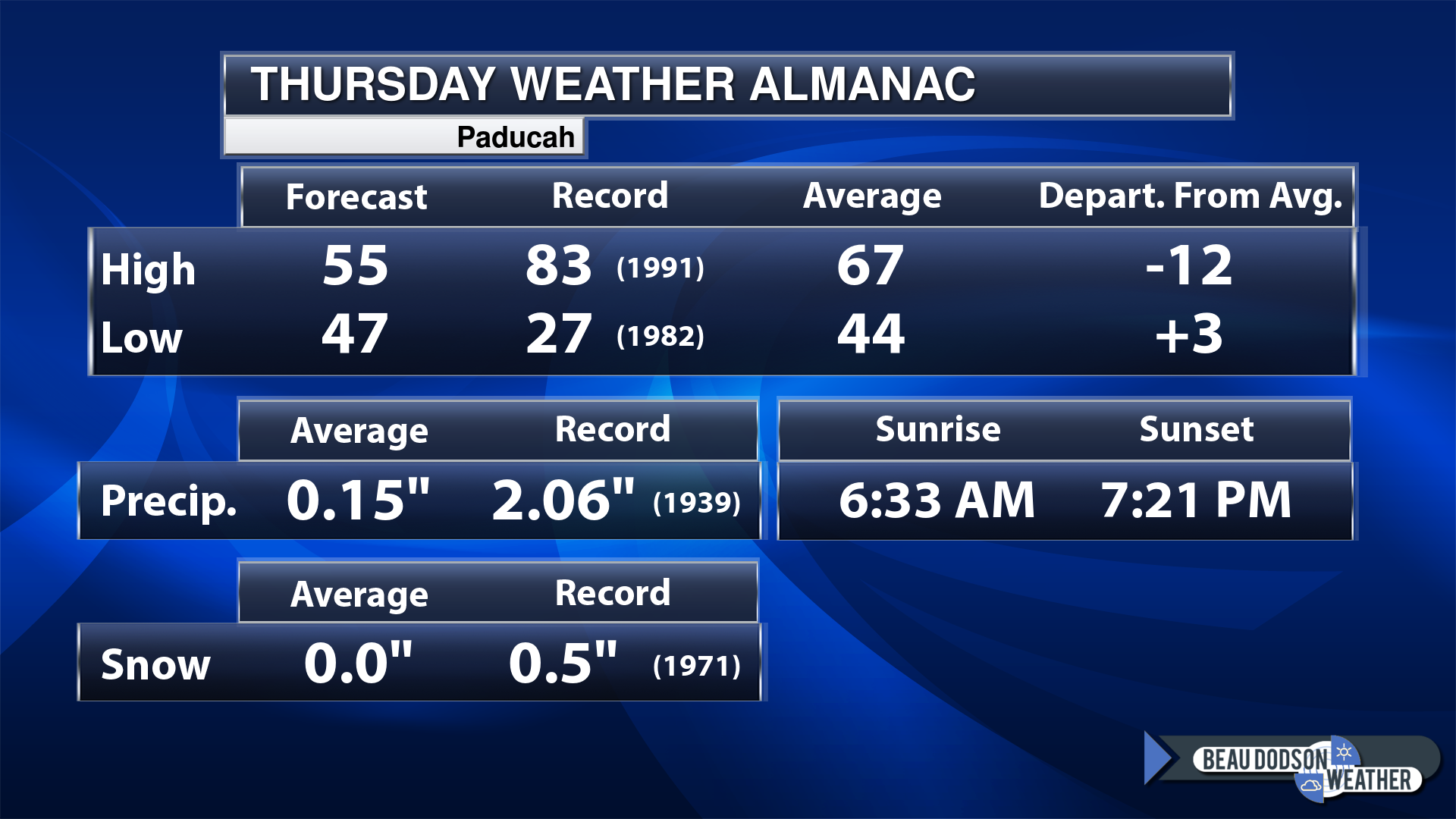
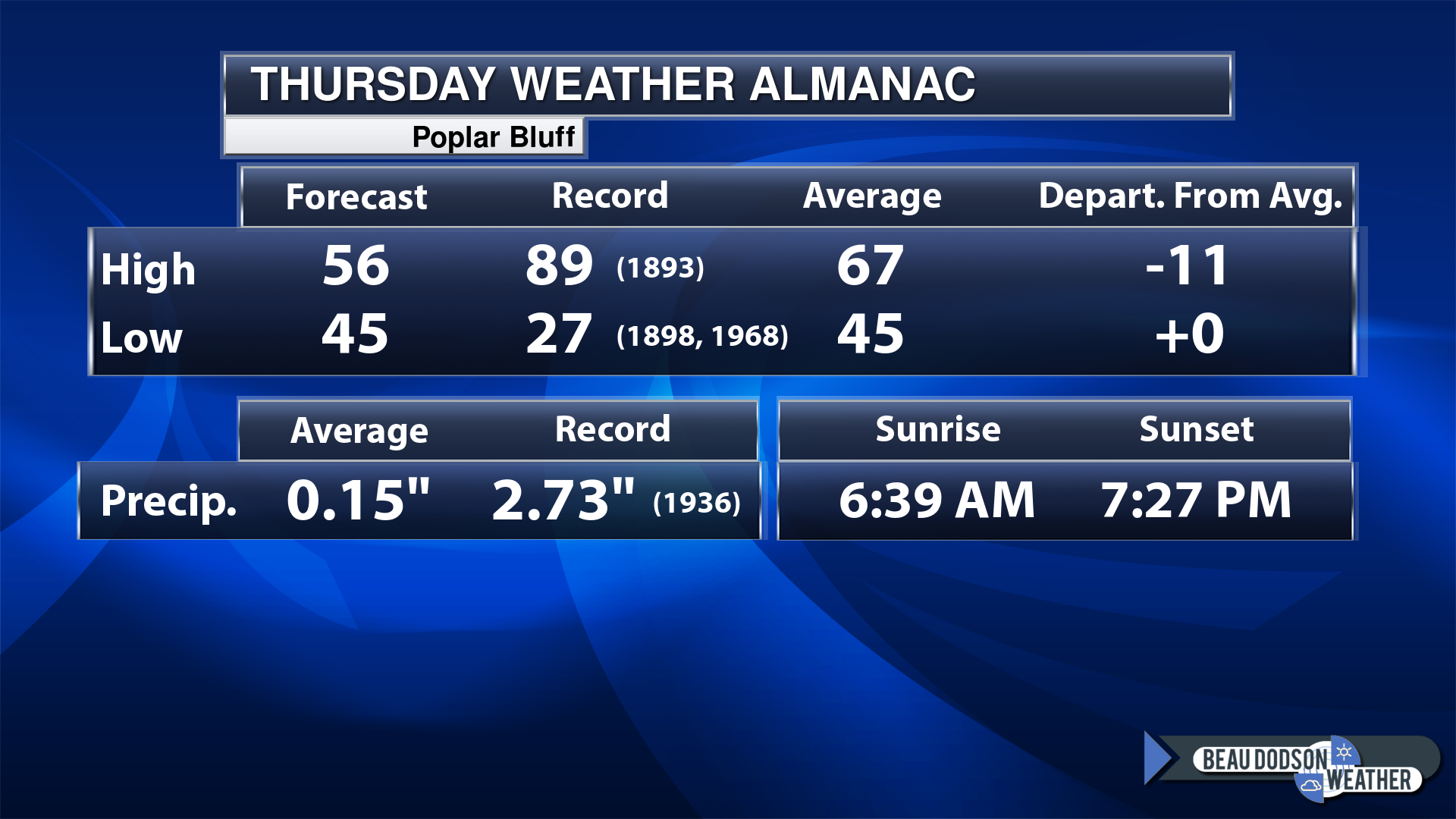
Today’s Local Almanacs (for a few select cities). Your location will be comparable.
Note, the low is this morning’s low and not tomorrows.
This shows you the forecast high. The records. The average and then the departure (how many degrees above or below average will temperatures be).
The graphic shows you what our average daily rainfall is for the day. That is not what is expected (that is the average from past years).
If you have not subscribed to my YouTube Channel then click on this link and it will take you to my videos.
Click the button below and it will take you to the Beau Dodson YouTube Channel.
48-hour forecast


.

.
Thursday to Thursday
1. Is lightning in the forecast? No.
2. Are severe thunderstorms in the forecast? No.
3. Is flash flooding in the forecast? No.
4. Will the wind chill dip below 10 degrees? No.
5. Is measurable snow and/or sleet in the forecast? No.
6. Is freezing rain/ice in the forecast? No.
Freezing rain is rain that falls and instantly freezes on objects such as trees and power lines
6. Will the heat index exceed 100 degrees? No.
.
Thursday, April 6, 2023
Confidence in the forecast? High Confidence
Thursday Forecast: Intervals of clouds. A chance of a few remaining showers and thunderstorms over our eastern counties.
What is the chance of precipitation?
Far northern southeast Missouri ~ 10%
Southeast Missouri ~ 10%
The Missouri Bootheel ~ 10%
I-64 Corridor of southern Illinois ~ 20%
Southern Illinois ~ 20%
Extreme southern Illinois (southern seven counties) ~ 20%
Far western Kentucky ~ 40%
The Pennyrile area of western KY ~ 60%
Northwest Kentucky (near Indiana border) ~ 40%
Northwest Tennessee ~ 40%
Coverage of precipitation: Numerous far east southeastern counties
Timing of the precipitation: Mainly before noon
Temperature range:
Far northern southeast Missouri ~ 54° to 58°
Southeast Missouri ~ 56° to 60°
The Missouri Bootheel ~ 54° to 58°
I-64 Corridor of southern Illinois ~ 54° to 58°
Southern Illinois ~ 54° to 58°
Extreme southern Illinois (southern seven counties) ~ 54° to 58°
Far western Kentucky ~ 54° to 58°
The Pennyrile area of western KY ~ 54° to 58°
Northwest Kentucky (near Indiana border) ~ 54° to 58°
Northwest Tennessee ~ 54° to 58°
Winds will be from this direction: North northwest 10 to 20 mph
Wind chill or heat index (feels like) temperature forecast: 54° to 58°
What impacts are anticipated from the weather? Wet roadways. Lightning.
Should I cancel my outdoor plans? No, but check the Beau Dodson Weather Radars.
UV Index: 4. Moderate
Sunrise: 6:34 AM
Sunset: 7:22 PM
.
Thursday night Forecast: Partly cloudy.
What is the chance of precipitation?
Far northern southeast Missouri ~ 0%
Southeast Missouri ~ 0%
The Missouri Bootheel ~ 0%
I-64 Corridor of southern Illinois ~ 0%
Southern Illinois ~ 0%
Extreme southern Illinois (southern seven counties) ~ 0%
Far western Kentucky ~ 0%
The Pennyrile area of western KY ~ 0%
Northwest Kentucky (near Indiana border) ~ 0%
Northwest Tennessee ~ 0%
Coverage of precipitation:
Timing of the precipitation:
Temperature range:
Far northern southeast Missouri ~ 34° to 38°
Southeast Missouri ~ 35° to 42°
The Missouri Bootheel ~ 38° to 40°
I-64 Corridor of southern Illinois ~ 38° to 42°
Southern Illinois ~ 38° to 42°
Extreme southern Illinois (southern seven counties) ~ 40° to 42°
Far western Kentucky ~ 40° to 44°
The Pennyrile area of western KY ~ 40° to 44°
Northwest Kentucky (near Indiana border) ~ 40° to 44°
Northwest Tennessee ~ 42° to 44°
Winds will be from this direction: Northeast 7 to 14 mph
Wind chill or heat index (feels like) temperature forecast: 36° to 42°
What impacts are anticipated from the weather?
Should I cancel my outdoor plans? No
Moonrise: 8:08 PM
Moonset: 6:52 AM
The phase of the moon: Full
.
Friday, April 7, 2023
Confidence in the forecast? High Confidence
Friday Forecast: Intervals of clouds. Breezy, at times.
What is the chance of precipitation?
Far northern southeast Missouri ~ 0%
Southeast Missouri ~ 0%
The Missouri Bootheel ~ 0%
I-64 Corridor of southern Illinois ~ 0%
Southern Illinois ~ 0%
Extreme southern Illinois (southern seven counties) ~ 0%
Far western Kentucky ~ 0%
The Pennyrile area of western KY ~ 0%
Northwest Kentucky (near Indiana border) ~ 0%
Northwest Tennessee ~ 0%
Coverage of precipitation:
Timing of the precipitation:
Temperature range:
Far northern southeast Missouri ~ 62° to 65°
Southeast Missouri ~ 62° to 65°
The Missouri Bootheel ~ 62° to 65°
I-64 Corridor of southern Illinois ~ 62° to 65°
Southern Illinois ~ 62° to 65°
Extreme southern Illinois (southern seven counties) ~ 62° to 65°
Far western Kentucky ~ 62° to 65°
The Pennyrile area of western KY ~ 62° to 65°
Northwest Kentucky (near Indiana border) ~ 62° to 65°
Northwest Tennessee ~ 62° to 65°
Winds will be from this direction: Northeast 10 to 20 mph. Gusty.
Wind chill or heat index (feels like) temperature forecast: 60° to 64°
What impacts are anticipated from the weather?
Should I cancel my outdoor plans? No
UV Index: 6. High
Sunrise: 6:33 AM
Sunset: 7:23 PM
.
Friday night Forecast: Partly cloudy.
What is the chance of precipitation?
Far northern southeast Missouri ~ 0%
Southeast Missouri ~ 0%
The Missouri Bootheel ~ 0%
I-64 Corridor of southern Illinois ~ 0%
Southern Illinois ~ 0%
Extreme southern Illinois (southern seven counties) ~ 0%
Far western Kentucky ~ 0%
The Pennyrile area of western KY ~ 0%
Northwest Kentucky (near Indiana border) ~ 0%
Northwest Tennessee ~ 0%
Coverage of precipitation:
Timing of the precipitation:
Temperature range:
Far northern southeast Missouri ~ 36° to 38°
Southeast Missouri ~ 38° to 40°
The Missouri Bootheel ~ 42° to 45°
I-64 Corridor of southern Illinois ~ 38° to 42°
Southern Illinois ~ 40° to 42°
Extreme southern Illinois (southern seven counties) ~ 40° to 44°
Far western Kentucky ~ 42° to 44°
The Pennyrile area of western KY ~ 42° to 44°
Northwest Kentucky (near Indiana border) ~ 42° to 44°
Northwest Tennessee ~ 42° to 44°
Winds will be from this direction: Northeast 10 to 20 mph. Gusty.
Wind chill or heat index (feels like) temperature forecast: 36° to 44°
What impacts are anticipated from the weather?
Should I cancel my outdoor plans? No
Moonrise: 9:13 PM
Moonset: 7:17 AM
The phase of the moon: Waning Gibbous
.
Saturday, April 8, 2023
Confidence in the forecast? High Confidence
Saturday Forecast: Intervals of clouds. Breezy, at times.
What is the chance of precipitation?
Far northern southeast Missouri ~ 0%
Southeast Missouri ~ 0%
The Missouri Bootheel ~ 0%
I-64 Corridor of southern Illinois ~ 0%
Southern Illinois ~ 0%
Extreme southern Illinois (southern seven counties) ~ 0%
Far western Kentucky ~ 0%
The Pennyrile area of western KY ~ 0%
Northwest Kentucky (near Indiana border) ~ 0%
Northwest Tennessee ~ 0%
Coverage of precipitation:
Timing of the precipitation:
Temperature range:
Far northern southeast Missouri ~ 64° to 68°
Southeast Missouri ~ 64° to 68°
The Missouri Bootheel ~ 64° to 68°
I-64 Corridor of southern Illinois ~ 64° to 68°
Southern Illinois ~ 64° to 68°
Extreme southern Illinois (southern seven counties) ~ 64° to 68°
Far western Kentucky ~ 64° to 68°
The Pennyrile area of western KY ~ 64° to 68°
Northwest Kentucky (near Indiana border) ~ 64° to 68°
Northwest Tennessee ~ 64° to 68°
Winds will be from this direction: Northeast 10 to 20 mph. Gusty.
Wind chill or heat index (feels like) temperature forecast: 62° to 68°
What impacts are anticipated from the weather?
Should I cancel my outdoor plans? No
UV Index: 7. High
Sunrise: 6:31 AM
Sunset: 7:24 PM
.
Saturday night Forecast: Partly cloudy.
What is the chance of precipitation?
Far northern southeast Missouri ~ 0%
Southeast Missouri ~ 0%
The Missouri Bootheel ~ 0%
I-64 Corridor of southern Illinois ~ 0%
Southern Illinois ~ 0%
Extreme southern Illinois (southern seven counties) ~ 0%
Far western Kentucky ~ 0%
The Pennyrile area of western KY ~ 0%
Northwest Kentucky (near Indiana border) ~ 0%
Northwest Tennessee ~ 0%
Coverage of precipitation:
Timing of the precipitation:
Temperature range:
Far northern southeast Missouri ~ 40° to 45°
Southeast Missouri ~ 42° to 45°
The Missouri Bootheel ~ 42° to 45°
I-64 Corridor of southern Illinois ~ 42° to 45°
Southern Illinois ~ 42° to 45°
Extreme southern Illinois (southern seven counties) ~ 42° to 45°
Far western Kentucky ~ 42° to 45°
The Pennyrile area of western KY ~ 42° to 45°
Northwest Kentucky (near Indiana border) ~ 43° to 46°
Northwest Tennessee ~ 44° to 46°
Winds will be from this direction: Northeast 10 to 20 mph. Gusty.
Wind chill or heat index (feels like) temperature forecast: 36° to 42°
What impacts are anticipated from the weather?
Should I cancel my outdoor plans? No
Moonrise: 10:22 PM
Moonset: 7:46 AM
The phase of the moon: Waning Gibbous
.
Sunday, April 9, 2023
Confidence in the forecast? High Confidence
Sunday Forecast: Partly sunny. Mild.
What is the chance of precipitation?
Far northern southeast Missouri ~ 0%
Southeast Missouri ~ 0%
The Missouri Bootheel ~ 0%
I-64 Corridor of southern Illinois ~ 0%
Southern Illinois ~ 0%
Extreme southern Illinois (southern seven counties) ~ 0%
Far western Kentucky ~ 0%
The Pennyrile area of western KY ~ 0%
Northwest Kentucky (near Indiana border) ~ 0%
Northwest Tennessee ~ 0%
Coverage of precipitation:
Timing of the precipitation:
Temperature range:
Far northern southeast Missouri ~ 66° to 68°
Southeast Missouri ~ 66° to 68°
The Missouri Bootheel ~ 66° to 68°
I-64 Corridor of southern Illinois ~ 66° to 68°
Southern Illinois ~ 66° to 68°
Extreme southern Illinois (southern seven counties) ~ 66° to 68°
Far western Kentucky ~ 66° to 68°
The Pennyrile area of western KY ~ 66° to 68°
Northwest Kentucky (near Indiana border) ~ 66° to 68°
Northwest Tennessee ~ 66° to 68°
Winds will be from this direction: Northeast 7 to 14 mph
Wind chill or heat index (feels like) temperature forecast: 64° to 68°
What impacts are anticipated from the weather?
Should I cancel my outdoor plans? No
UV Index: 7. High
Sunrise: 6:30 AM
Sunset: 7:25 PM
.
Sunday night Forecast: Partly cloudy.
What is the chance of precipitation?
Far northern southeast Missouri ~ 0%
Southeast Missouri ~ 0%
The Missouri Bootheel ~ 0%
I-64 Corridor of southern Illinois ~ 0%
Southern Illinois ~ 0%
Extreme southern Illinois (southern seven counties) ~ 0%
Far western Kentucky ~ 0%
The Pennyrile area of western KY ~ 0%
Northwest Kentucky (near Indiana border) ~ 0%
Northwest Tennessee ~ 0%
Coverage of precipitation:
Timing of the precipitation:
Temperature range:
Far northern southeast Missouri ~ 44° to 48°
Southeast Missouri ~ 44° to 48°
The Missouri Bootheel ~ 44° to 48°
I-64 Corridor of southern Illinois ~ 44° to 48°
Southern Illinois ~ 44° to 48°
Extreme southern Illinois (southern seven counties) ~ 44° to 48°
Far western Kentucky ~ 44° to 48°
The Pennyrile area of western KY ~ 44° to 48°
Northwest Kentucky (near Indiana border) ~ 44° to 48°
Northwest Tennessee ~ 44° to 48°
Winds will be from this direction: Northeast 6 to 12 mph.
Wind chill or heat index (feels like) temperature forecast: 44° to 48°
What impacts are anticipated from the weather?
Should I cancel my outdoor plans? No
Moonrise: 11:32 PM
Moonset: 8:21 AM
The phase of the moon: Waning Gibbous
Click here if you would like to return to the top of the page.
-
- A few showers today over our southeast counties.
- Finally, some quiet weather.
Weather advice:
As we prepare for spring, let’s make sure you have three to five ways of receiving your severe weather information.
.
Forecast Discussion
Okay, finally some quiet weather.
Severe thunderstorms pushed across our region yesterday killing at least 5 people and injuring scores of others.
There were tornadoes reported in Bollinger County, Missouri and Calloway County, Illinois. In the LBL area, as well. The NWS will be conducting storm surveys to determine the strength of the tornadoes.
The Bollinger County tornado has a preliminary rating of a high end EF2.
Those storms have pushed off to our east southeast.
We still have the cold front slowly moving through our eastern counties. There have been some showers along the front this morning and those will continue to stream east northeast through our far southeastern counties.
Otherwise, dry conditions today for the rest of the area.
Our weather is going to be quiet as we enter the weekend into next week. No serious weather concerns in the forecast. It hasn’t been this quiet since mid-December! I guess we did earn a bit of a break.
The long range is warmer than average, as well. Some nice spring weather ahead of us.
.
Click here if you would like to return to the top of the page.
This outlook covers southeast Missouri, southern Illinois, western Kentucky, and far northwest Tennessee.
Today through March 31st: I am closely monitoring a storm system that is forecast to arrive Friday. A cold front will move across the region. This front will have strong wind shear and moisture to work with. Severe thunderstorms are possible/likely in the region. This event is still several days away, but data does indicate the potential of damaging wind, hail, and even a tornado. Monitor updates.
The primary time-frame of concern will be Friday afternoon and evening.
.
Today’s Storm Prediction Center’s Severe Weather Outlook
Light green is where thunderstorms may occur but should be below severe levels.
Dark green is a level one risk. Yellow is a level two risk. Orange is a level three (enhanced) risk. Red is a level four (moderate) risk. Pink is a level five (high) risk.
One is the lowest risk. Five is the highest risk.
A severe storm is one that produces 58 mph wind or higher, quarter size hail, and/or a tornado.
Explanation of tables. Click here.

.
Tornado Probability Outlook

.
Large Hail Probability Outlook

.
High wind Probability Outlook

.
Tomorrow’s severe weather outlook.

.
Day Three Severe Weather Outlook

.

.
The images below are from NOAA’s Weather Prediction Center.
24-hour precipitation outlook..
 .
.
.
48-hour precipitation outlook.
. .
.
![]()
_______________________________________
.

Click here if you would like to return to the top of the page.
Again, as a reminder, these are models. They are never 100% accurate. Take the general idea from them.
What should I take from these?
- The general idea and not specifics. Models usually do well with the generalities.
- The time-stamp is located in the upper left corner.
.
What am I looking at?
You are looking at computer model data. Meteorologists use many different models to forecast the weather.
Occasionally, these maps are in Zulu time. 12z=7 AM. 18z=1 PM. 00z=7 PM. 06z=1 AM
Green represents light rain. Dark green represents moderate rain. Yellow and orange represent heavier rain.
This animation is the NAM 3K Model.
This animation is the Hrrr Model.
.
..![]()

.
Click here if you would like to return to the top of the page.
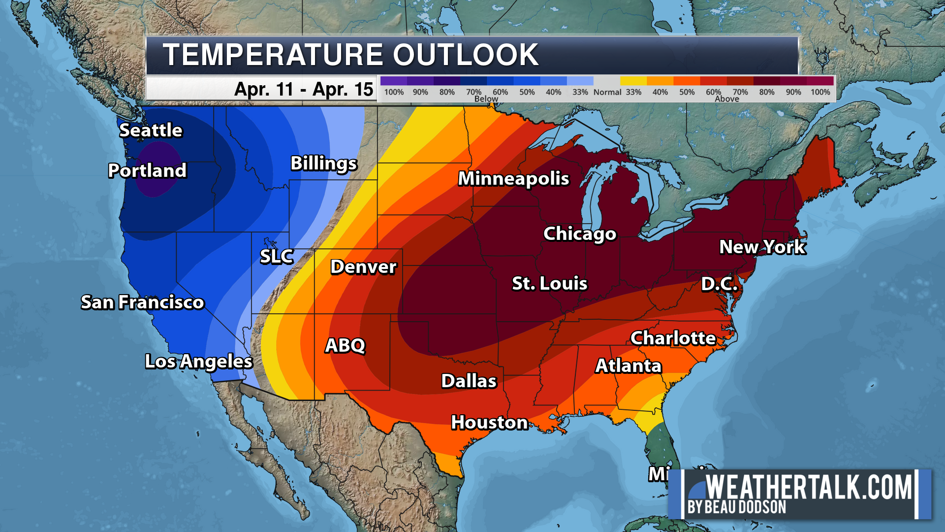
.Average high temperatures for this time of the year are around 60 degrees.
Average low temperatures for this time of the year are around 40 degrees.
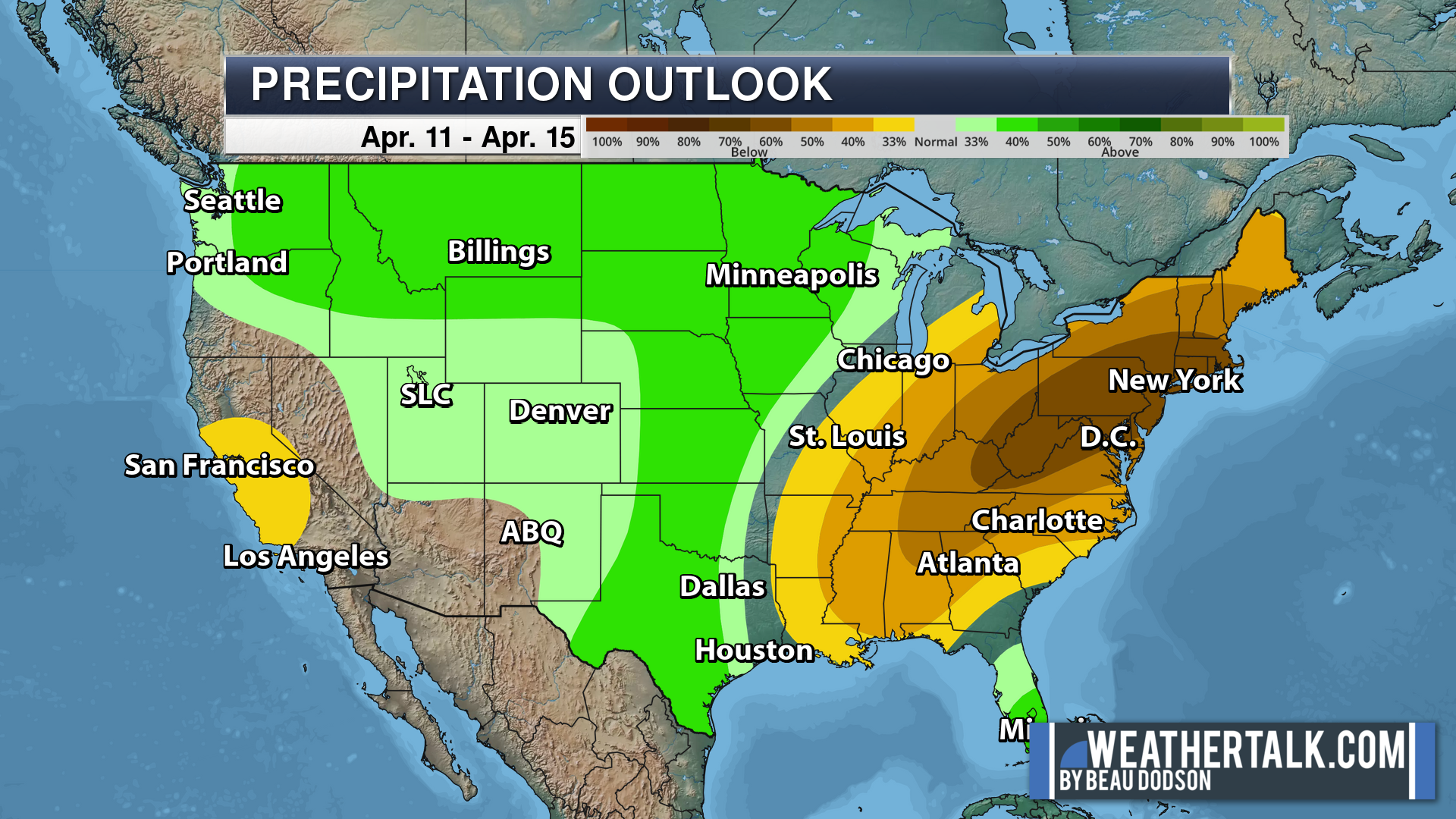
Average precipitation during this time period ranges from 0.80″ to 1.00″
Six to Ten Day Outlook.
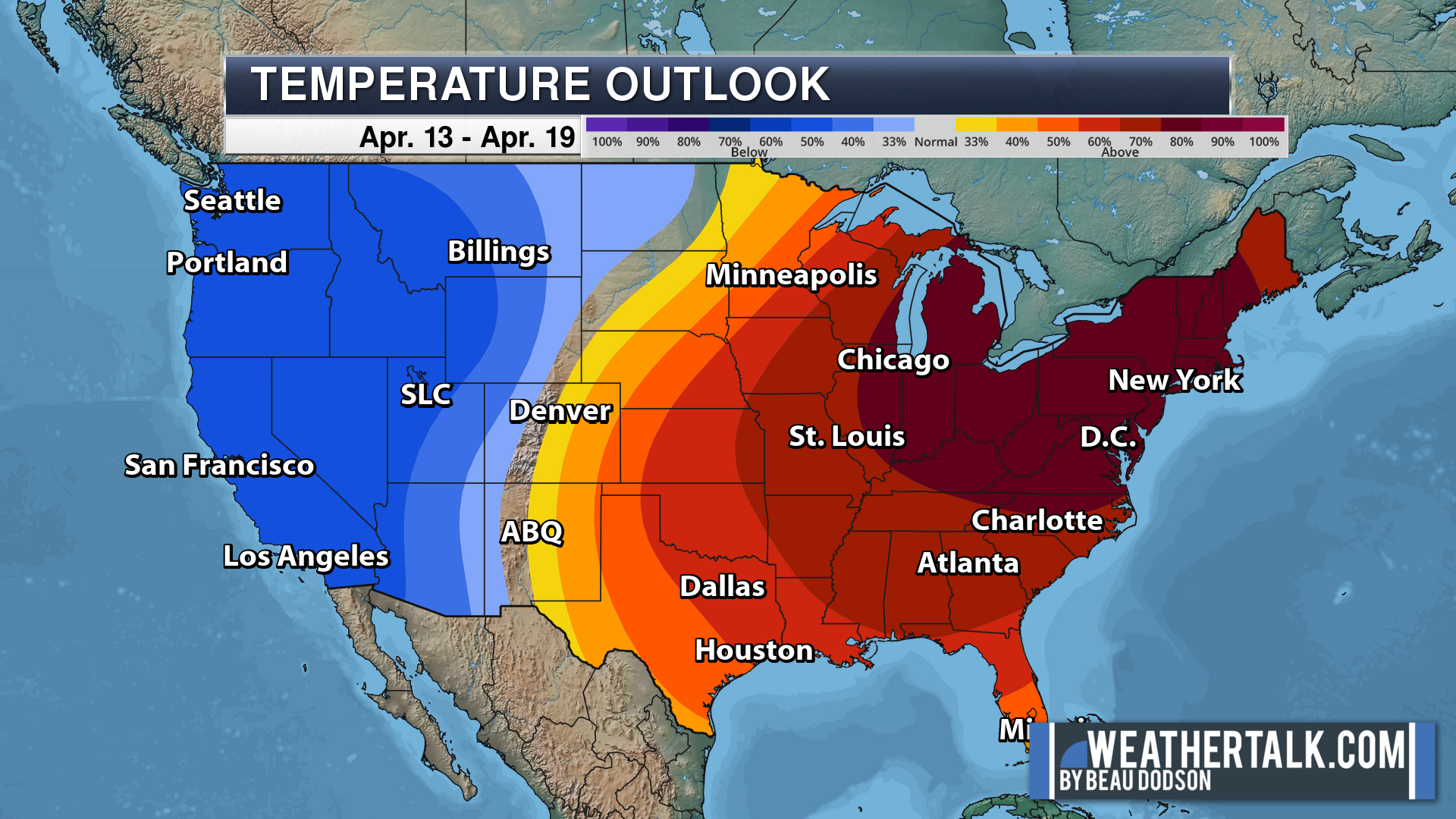
Blue is below average. Red is above average. The no color zone represents equal chances.
Average highs for this time of the year are in the lower 60s. Average lows for this time of the year are in the lower 40s.
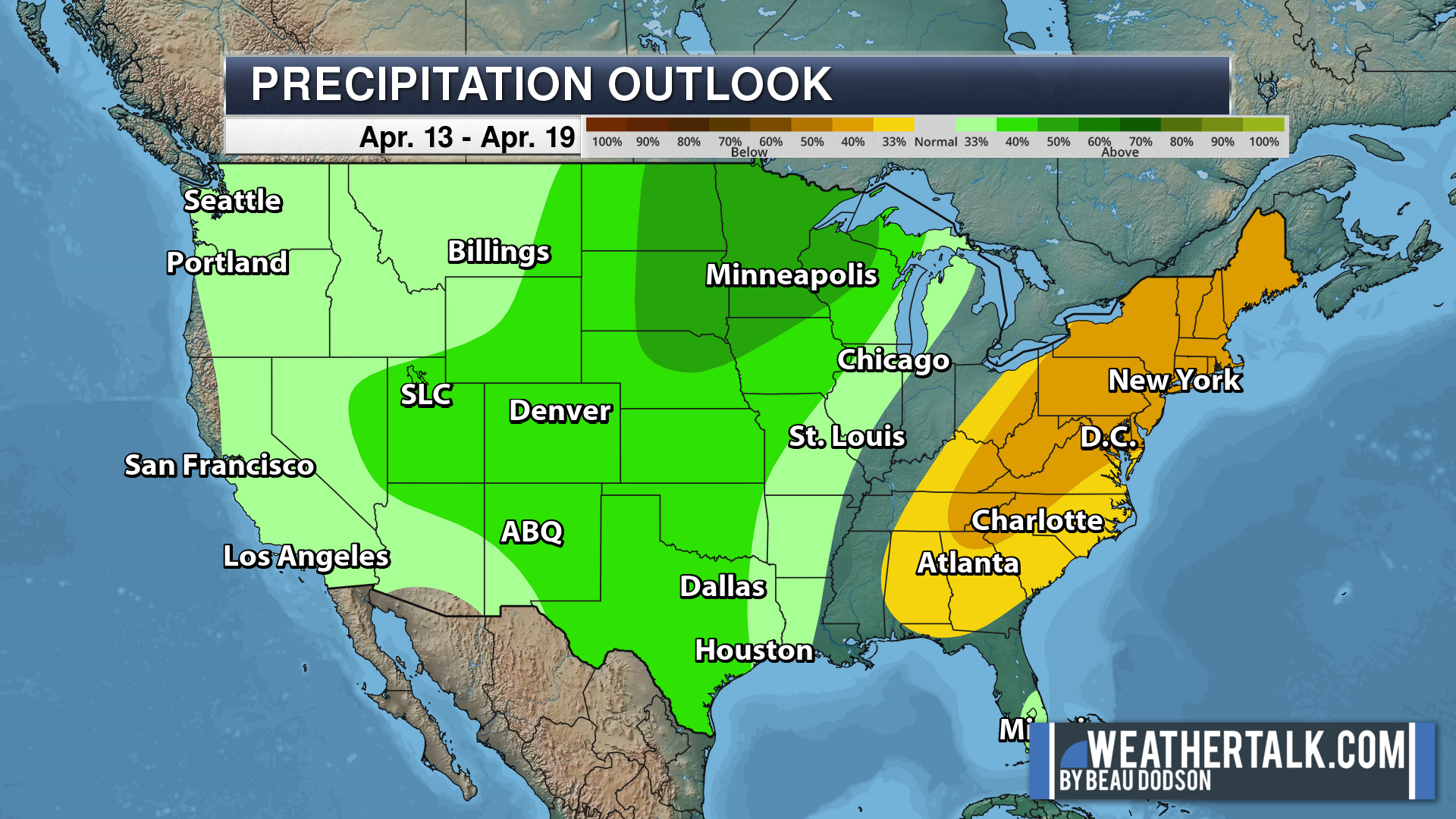
Green is above average precipitation. Yellow and brown favors below average precipitation. Average precipitation for this time of the year is around one inch per week.
.

Average low temperatures for this time of the year are around 42 degrees.
Average precipitation during this time period ranges from 0.80″ to 1.00″
.
.
![]()
The app is for subscribers. Subscribe at www.weathertalk.com/welcome then go to your app store and search for WeatherTalk
Subscribers, PLEASE USE THE APP. ATT and Verizon are not reliable during severe weather. They are delaying text messages.
The app is under WeatherTalk in the app store.
Apple users click here
Android users click here
.

Radars and Lightning Data
Interactive-city-view radars. Clickable watches and warnings.
https://wtalk.co/B3XHASFZ
If the radar is not updating then try another one. If a radar does not appear to be refreshing then hit Ctrl F5. You may also try restarting your browser.
Backup radar site in case the above one is not working.
https://weathertalk.com/morani
Regional Radar
https://imagery.weathertalk.com/prx/RadarLoop.mp4
** NEW ** Zoom radar with chaser tracking abilities!
ZoomRadar
Lightning Data (zoom in and out of your local area)
https://wtalk.co/WJ3SN5UZ
Not working? Email me at beaudodson@usawx.com
National map of weather watches and warnings. Click here.
Storm Prediction Center. Click here.
Weather Prediction Center. Click here.
.

Live lightning data: Click here.
Real time lightning data (another one) https://map.blitzortung.org/#5.02/37.95/-86.99
Our new Zoom radar with storm chases
.
.

Interactive GOES R satellite. Track clouds. Click here.
GOES 16 slider tool. Click here.
College of DuPage satellites. Click here
.

Here are the latest local river stage forecast numbers Click Here.
Here are the latest lake stage forecast numbers for Kentucky Lake and Lake Barkley Click Here.
.
.
Find Beau on Facebook! Click the banner.








 .
.