
Click one of the links below to take you directly to that section
![]()
![]()
![]()
![]()
![]()
![]()
![]()
.

.
Seven Day Hazardous Weather Outlook
1. Is lightning in the forecast? YES. Lightning is possible Saturday night into Sunday night. Another chance Monday night into Wednesday.
2. Are severe thunderstorms in the forecast? MONITOR. I will keep an eye on Tuesday and Wednesday.
3. Is flash flooding in the forecast? NOT AT THIS TIME.
4. Will non-thunderstorm winds top 40 mph? NOT AT THIS TIME.
5. Will the heat index exceed 100 degrees? NO.
6. Will the wind chill dip below 10 degrees? NO.
7. Is measurable snow and/or sleet in the forecast? NO.
8. Is freezing rain/ice in the forecast? NO.
Freezing rain is rain that falls and instantly freezes on objects such as trees and power lines Freezing fog possible, as well.
.

Fire weather risk level.
Thursday through Thursday night: 3. Very low risk.
Friday: 4. Low risk.
Friday night: 4. Low risk.
Fire Weather Discussion
As deepening low pressure stalls to our northeast, wrap-around showers continue to move through the Quad State. Some of these showers include graupel or small hail. Gusty WNW winds today will remain breezy overnight through tomorrow as shower activity slowly trends lesser. There is frost/freeze potential for the end of the week but lingering winds will limit development. The next round of showers and a few storms moves through Sunday with dry conditions Monday.
A Haines Index of 6 means a high potential for an existing fire to become large or exhibit erratic fire behavior, 5 means medium potential, 4 means low potential, and anything less than 4 means very low potential.
.

THE FORECAST IS GOING TO VARY FROM LOCATION TO LOCATION.
Scroll down to see your local forecast details.
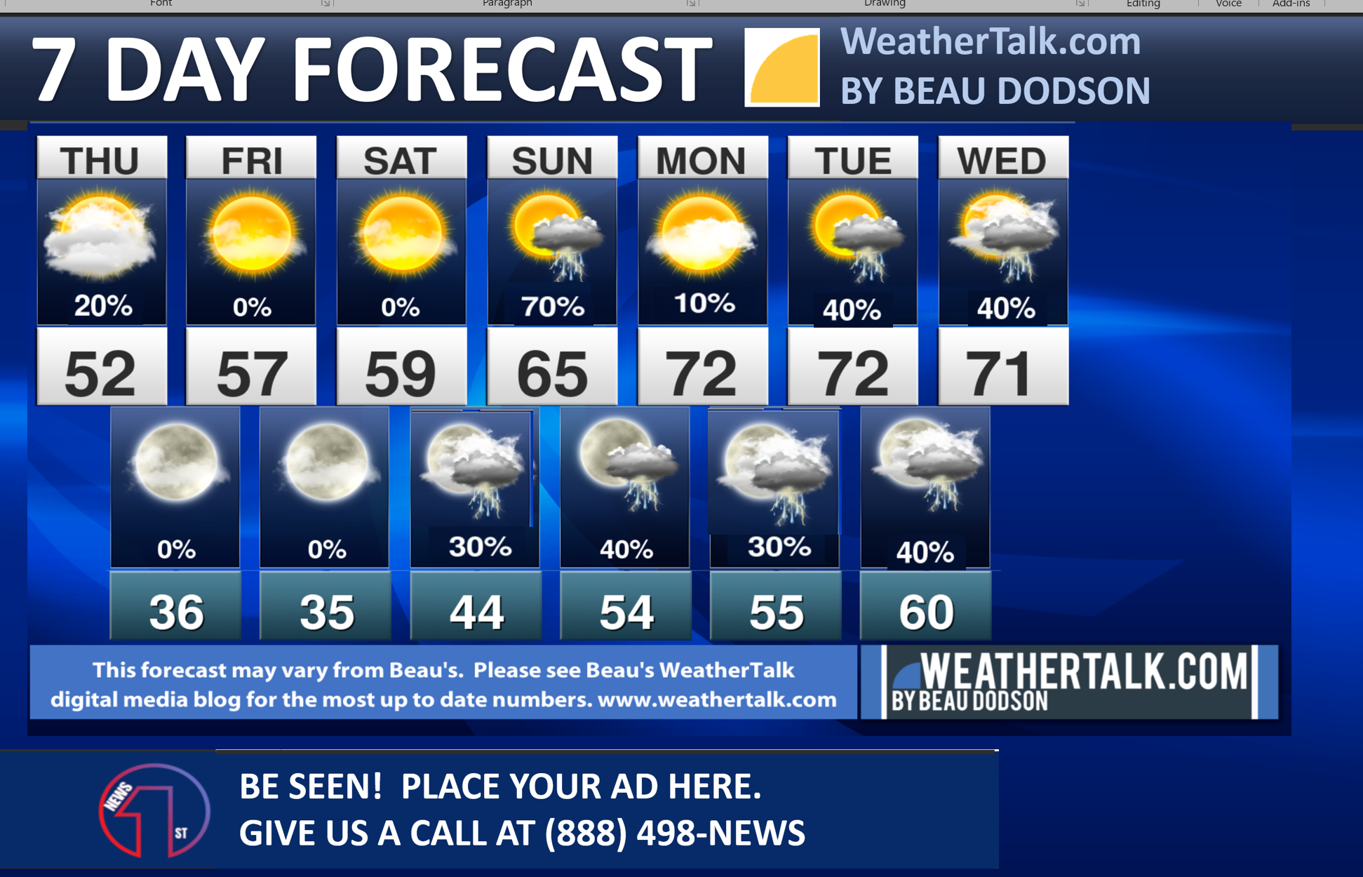
Seven-day forecast for southeast Missouri, southern Illinois, western Kentucky, and western Tennessee.
This is a BLEND for the region. Scroll down to see the region by region forecast.
48-hour forecast Graphics


.
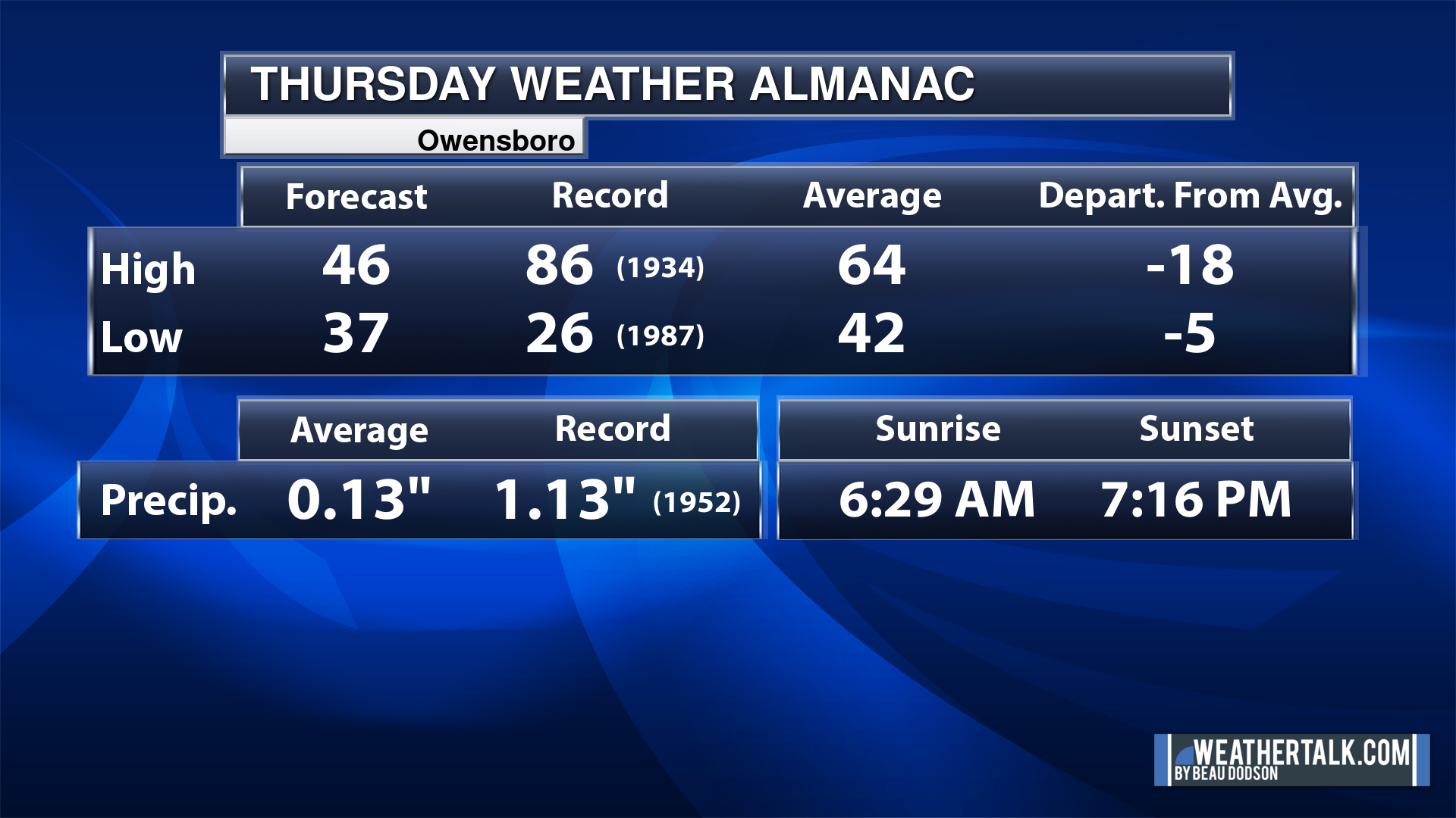
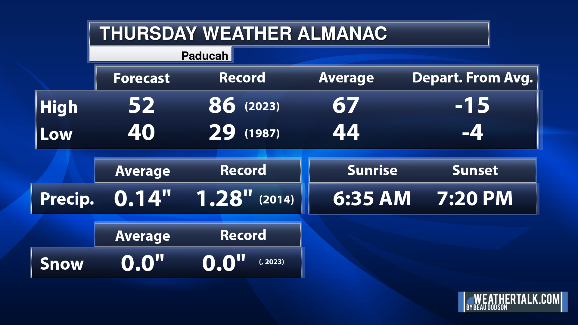
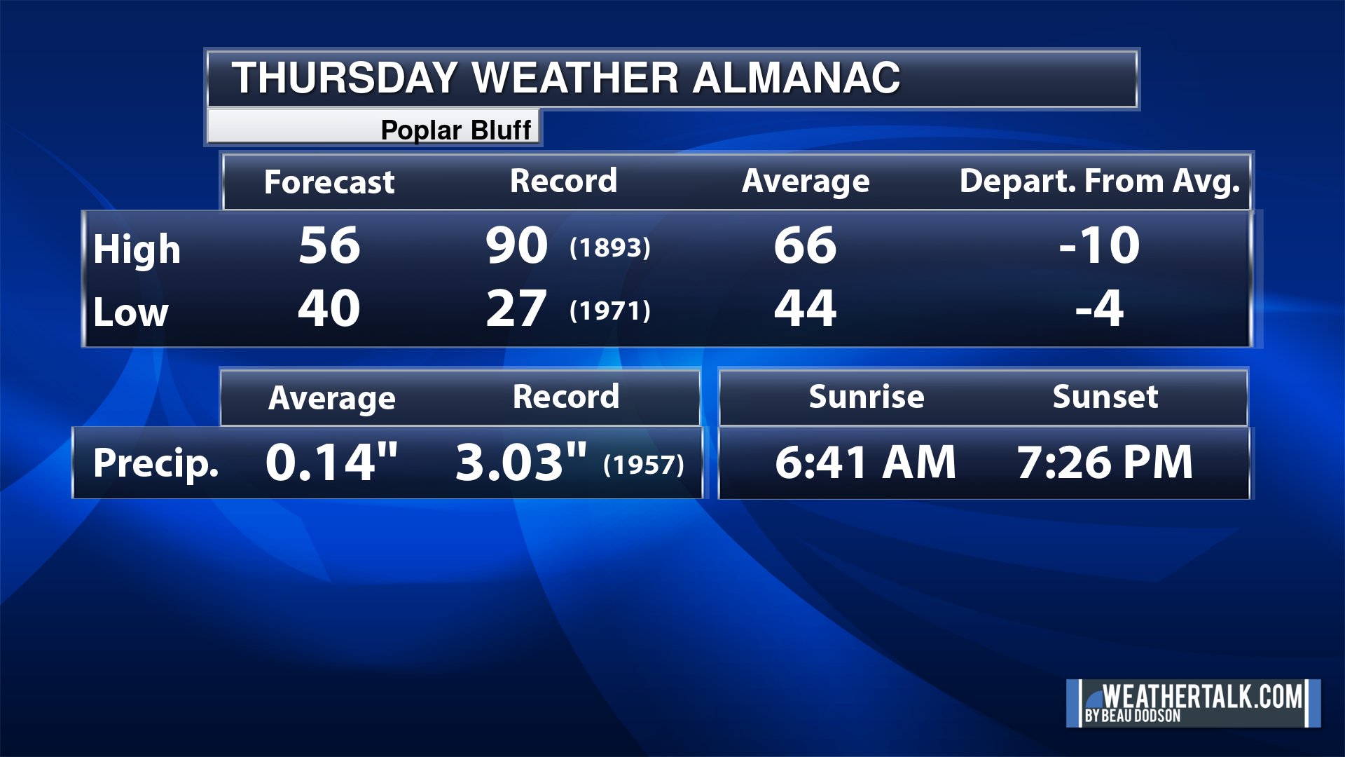
Today’s Local Almanacs (for a few select cities). Your location will be comparable.
Note, the low is this morning’s low and not tomorrows.
The forecast temperature shows you today’s expected high and this morning’s low.
The graphic shows you the record high and record low for today. It shows you what year that occurred, as well.
It then shows you what today’s average temperature is.
It shows you the departures (how may degrees above or below average temperatures will be ).
It shows you the average precipitation for today. Average comes from thirty years of rain totals.
It also shows you the record rainfall for the date and what year that occurred.
The sunrise and sunset are also shown.


![]()
.
.
Thursday Forecast: A mix of sun and clouds. A light sprinkle remaining in the region will be possible. The bulk of the rain has moved off to the east. Clouds may actually increase during the afternoon hours from east to west.
What is the chance of precipitation?
Far northern southeast Missouri ~ 10%
Southeast Missouri ~ 10%
The Missouri Bootheel ~ 10%
I-64 Corridor of southern Illinois ~ 20%
Southern Illinois ~ 20%
Extreme southern Illinois (southern seven counties) ~ 20%
Far western Kentucky (Purchase area) ~ 20%
The Pennyrile area of western KY ~ 20%
Northwest Kentucky (near Indiana border) ~ 20%
Northwest Tennessee ~ 10%
Coverage of precipitation: Isolated
Timing of the precipitation: Any given point of time
Far northern southeast Missouri ~ 46° to 48°
Southeast Missouri ~ 53° to 56°
The Missouri Bootheel ~ 54° to 58°
I-64 Corridor of southern Illinois ~ 46° to 48°
Southern Illinois ~ 48° to 52°
Extreme southern Illinois (southern seven counties) ~ 50° to 52°
Far western Kentucky ~ 52° to 54°
The Pennyrile area of western KY ~ 52° to 54°
Northwest Kentucky (near Indiana border) ~ 52° to 54°
Northwest Tennessee ~ 52° to 55°
Winds will be from this direction: West northwest 8 to 16 mph
Wind chill or heat index (feels like) temperature forecast: 42° to 52°
What impacts are anticipated from the weather?
Should I cancel my outdoor plans? No
UV Index: 7. High
Sunrise: 6:37 AM
Sunset: 7:20 PM
.
Thursday Night Forecast: Intervals of clouds. Chilly.
What is the chance of precipitation?
Far northern southeast Missouri ~ 0%
Southeast Missouri ~ 0%
The Missouri Bootheel ~ 0%
I-64 Corridor of southern Illinois ~ 0%
Southern Illinois ~ 0%
Extreme southern Illinois (southern seven counties) ~ 0%
Far western Kentucky (Purchase area) ~ 0%
The Pennyrile area of western KY ~ 0%
Northwest Kentucky (near Indiana border) ~ 0%
Northwest Tennessee ~ 0%
Coverage of precipitation:
Timing of the precipitation:
Temperature range:
Far northern southeast Missouri ~ 32° to 34°
Southeast Missouri ~ 33° to 35°
The Missouri Bootheel ~ 34° to 36°
I-64 Corridor of southern Illinois ~ 32° to 34°
Southern Illinois ~ 32° to 35°
Extreme southern Illinois (southern seven counties) ~ 33° to 36°
Far western Kentucky ~ 33° to 36°
The Pennyrile area of western KY ~ 33° to 36°
Northwest Kentucky (near Indiana border) ~ 34° to 36°
Northwest Tennessee ~ 34° to 38°
Winds will be from this direction: North 6 to 12 mph
Wind chill or heat index (feels like) temperature forecast: 30° to 35°
What impacts are anticipated from the weather? Monitor frost risks.
Should I cancel my outdoor plans? No
Moonrise: 3:44 AM
Moonset: 1:22 PM
The phase of the moon: Waning Crescent
.
Friday Forecast: Partly sunny. Cool.
What is the chance of precipitation?
Far northern southeast Missouri ~ 0%
Southeast Missouri ~ 0%
The Missouri Bootheel ~ 0%
I-64 Corridor of southern Illinois ~ 0%
Southern Illinois ~ 0%
Extreme southern Illinois (southern seven counties) ~ 0%
Far western Kentucky (Purchase area) ~ 0%
The Pennyrile area of western KY ~ 0%
Northwest Kentucky (near Indiana border) ~ 0%
Northwest Tennessee ~ 0%
Coverage of precipitation:
Timing of the precipitation:
Far northern southeast Missouri ~ 53° to 56°
Southeast Missouri ~ 53° to 56°
The Missouri Bootheel ~ 56° to 58°
I-64 Corridor of southern Illinois ~ 53° to 56°
Southern Illinois ~ 53° to 56°
Extreme southern Illinois (southern seven counties) ~ 53° to 56°
Far western Kentucky ~ 53° to 56°
The Pennyrile area of western KY ~ 53° to 56°
Northwest Kentucky (near Indiana border) ~ 53° to 56°
Northwest Tennessee ~ 56° to 58°
Winds will be from this direction: Northwest 7 to 14 mph
Wind chill or heat index (feels like) temperature forecast: 50° to 58°
What impacts are anticipated from the weather?
Should I cancel my outdoor plans? No
UV Index: 5. Moderate
Sunrise: 6:37 AM
Sunset: 7:20 PM
.
Friday Night Forecast: Mostly clear. Cold. If winds subside, then patchy frost and/or light freeze conditions.
What is the chance of precipitation?
Far northern southeast Missouri ~ 0%
Southeast Missouri ~ 0%
The Missouri Bootheel ~ 0%
I-64 Corridor of southern Illinois ~ 0%
Southern Illinois ~ 0%
Extreme southern Illinois (southern seven counties) ~ 0%
Far western Kentucky (Purchase area) ~ 0%
The Pennyrile area of western KY ~ 0%
Northwest Kentucky (near Indiana border) ~ 0%
Northwest Tennessee ~ 0%
Coverage of precipitation:
Timing of the precipitation:
Temperature range:
Far northern southeast Missouri ~ 30° to 32°
Southeast Missouri ~ 30° to 34°
The Missouri Bootheel ~ 32° to 34°
I-64 Corridor of southern Illinois ~ 30° to 32°
Southern Illinois ~ 30° to 34°
Extreme southern Illinois (southern seven counties) ~ 32° to 34°
Far western Kentucky ~ 32° to 34°
The Pennyrile area of western KY ~ 32° to 34°
Northwest Kentucky (near Indiana border) ~ 32° to 34°
Northwest Tennessee ~ 32° to 35°
Winds will be from this direction: North northeast 6 to 12 mph
Wind chill or heat index (feels like) temperature forecast: 28° to 34°
What impacts are anticipated from the weather? Frost possible
Should I cancel my outdoor plans? No
Moonrise: 3:44 AM
Moonset: 1:22 PM
The phase of the moon: Waning Crescent
.
Saturday Forecast: Mostly sunny. A bit warmer.
What is the chance of precipitation?
Far northern southeast Missouri ~ 0%
Southeast Missouri ~ 0%
The Missouri Bootheel ~ 0%
I-64 Corridor of southern Illinois ~ 0%
Southern Illinois ~ 0%
Extreme southern Illinois (southern seven counties) ~ 0%
Far western Kentucky (Purchase area) ~ 0%
The Pennyrile area of western KY ~ 0%
Northwest Kentucky (near Indiana border) ~ 0%
Northwest Tennessee ~ 0%
Coverage of precipitation:
Timing of the precipitation:
Far northern southeast Missouri ~ 60° to 64°
Southeast Missouri ~ 60° to 64°
The Missouri Bootheel ~ 60° to 64°
I-64 Corridor of southern Illinois ~ 60° to 64°
Southern Illinois ~ 60° to 64°
Extreme southern Illinois (southern seven counties) ~ 60° to 64°
Far western Kentucky ~ 60° to 64°
The Pennyrile area of western KY ~ 60° to 64°
Northwest Kentucky (near Indiana border) ~ 60° to 64°
Northwest Tennessee ~ 60° to 64°
Winds will be from this direction: East southeast 5 to 10 mph
Wind chill or heat index (feels like) temperature forecast: 60° to 64°
What impacts are anticipated from the weather? Morning frost
Should I cancel my outdoor plans? No
UV Index: 5. Moderate
Sunrise: 6:37 AM
Sunset: 7:20 PM
.
Saturday Night Forecast: Partly cloudy. A chance of showers and thunderstorms. Mainly late.
What is the chance of precipitation?
Far northern southeast Missouri ~ 30%
Southeast Missouri ~ 30%
The Missouri Bootheel ~ 30%
I-64 Corridor of southern Illinois ~ 20%
Southern Illinois ~ 30%
Extreme southern Illinois (southern seven counties) ~ 20%
Far western Kentucky (Purchase area) ~ 30%
The Pennyrile area of western KY ~ 20%
Northwest Kentucky (near Indiana border) ~ 20%
Northwest Tennessee ~ 20%
Coverage of precipitation: Scattered
Timing of the precipitation: After 12 am
Temperature range:
Far northern southeast Missouri ~ 40° to 44°
Southeast Missouri ~ 42° to 44°
The Missouri Bootheel ~ 42° to 44°
I-64 Corridor of southern Illinois ~ 42° to 44°
Southern Illinois ~ 42° to 44°
Extreme southern Illinois (southern seven counties) ~ 42° to 44°
Far western Kentucky ~ 42° to 44°
The Pennyrile area of western KY ~ 42° to 44°
Northwest Kentucky (near Indiana border) ~ 42° to 44°
Northwest Tennessee ~ 42° to 44°
Winds will be from this direction: East southeast 10 to 20 mph
Wind chill or heat index (feels like) temperature forecast: 38° to 44°
What impacts are anticipated from the weather?
Should I cancel my outdoor plans? No
Moonrise: 3:44 AM
Moonset: 1:22 PM
The phase of the moon: Waning Crescent
.
Sunday Forecast: Increasing clouds. A chance of showers and thunderstorms.
What is the chance of precipitation?
Far northern southeast Missouri ~ 70%
Southeast Missouri ~ 70%
The Missouri Bootheel ~ 70%
I-64 Corridor of southern Illinois ~ 70%
Southern Illinois ~ 70%
Extreme southern Illinois (southern seven counties) ~ 70%
Far western Kentucky (Purchase area) ~ 70%
The Pennyrile area of western KY ~ 70%
Northwest Kentucky (near Indiana border) ~ 70%
Northwest Tennessee ~ 70%
Coverage of precipitation: Numerous
Timing of the precipitation: Any given point of time
Far northern southeast Missouri ~ 64° to 66°
Southeast Missouri ~ 66° to 70°
The Missouri Bootheel ~ 70° to 74°
I-64 Corridor of southern Illinois ~ 66° to 68°
Southern Illinois ~ 68° to 70°
Extreme southern Illinois (southern seven counties) ~ 68° to 72°
Far western Kentucky ~ 70° to 74°
The Pennyrile area of western KY ~ 70° to 74°
Northwest Kentucky (near Indiana border) ~ 70° to 72°
Northwest Tennessee ~ 70° to 74°
Winds will be from this direction: South 10 to 25 mph
Wind chill or heat index (feels like) temperature forecast: 62° to 74°
What impacts are anticipated from the weather? Wet roadways. Lightning.
Should I cancel my outdoor plans? Have a plan B and monitor the Beau Dodson Weather Radars
UV Index: 5. Moderate
Sunrise: 6:37 AM
Sunset: 7:20 PM
.
Sunday Night Forecast: Mostly cloudy. A chance of a few remaining showers and thunderstorms.
What is the chance of precipitation?
Far northern southeast Missouri ~ 30%
Southeast Missouri ~ 30%
The Missouri Bootheel ~ 30%
I-64 Corridor of southern Illinois ~ 40%
Southern Illinois ~ 40%
Extreme southern Illinois (southern seven counties) ~ 40%
Far western Kentucky (Purchase area) ~ 40%
The Pennyrile area of western KY ~ 60%
Northwest Kentucky (near Indiana border) ~ 40%
Northwest Tennessee ~ 40%
Coverage of precipitation: Scattered – ending west to east
Timing of the precipitation: Mainly before 2 AM
Temperature range:
Far northern southeast Missouri ~ 48° to 52°
Southeast Missouri ~ 48° to 52°
The Missouri Bootheel ~ 50° to 55°
I-64 Corridor of southern Illinois ~ 48° to 52°
Southern Illinois ~ 52° to 55°
Extreme southern Illinois (southern seven counties) ~ 50° to 55°
Far western Kentucky ~ 52° to 55°
The Pennyrile area of western KY ~ 54° to 56°
Northwest Kentucky (near Indiana border) ~ 52° to 55°
Northwest Tennessee ~ 52° to 55°
Winds will be from this direction: South 7 to 14 mph
Wind chill or heat index (feels like) temperature forecast: 48° to 55°
What impacts are anticipated from the weather? Wet roadways. Lightning.
Should I cancel my outdoor plans? No, but check the Beau Dodson Weather Radars
Moonrise: 3:44 AM
Moonset: 1:22 PM
The phase of the moon: Waning Crescent
.
Click here if you would like to return to the top of the page.

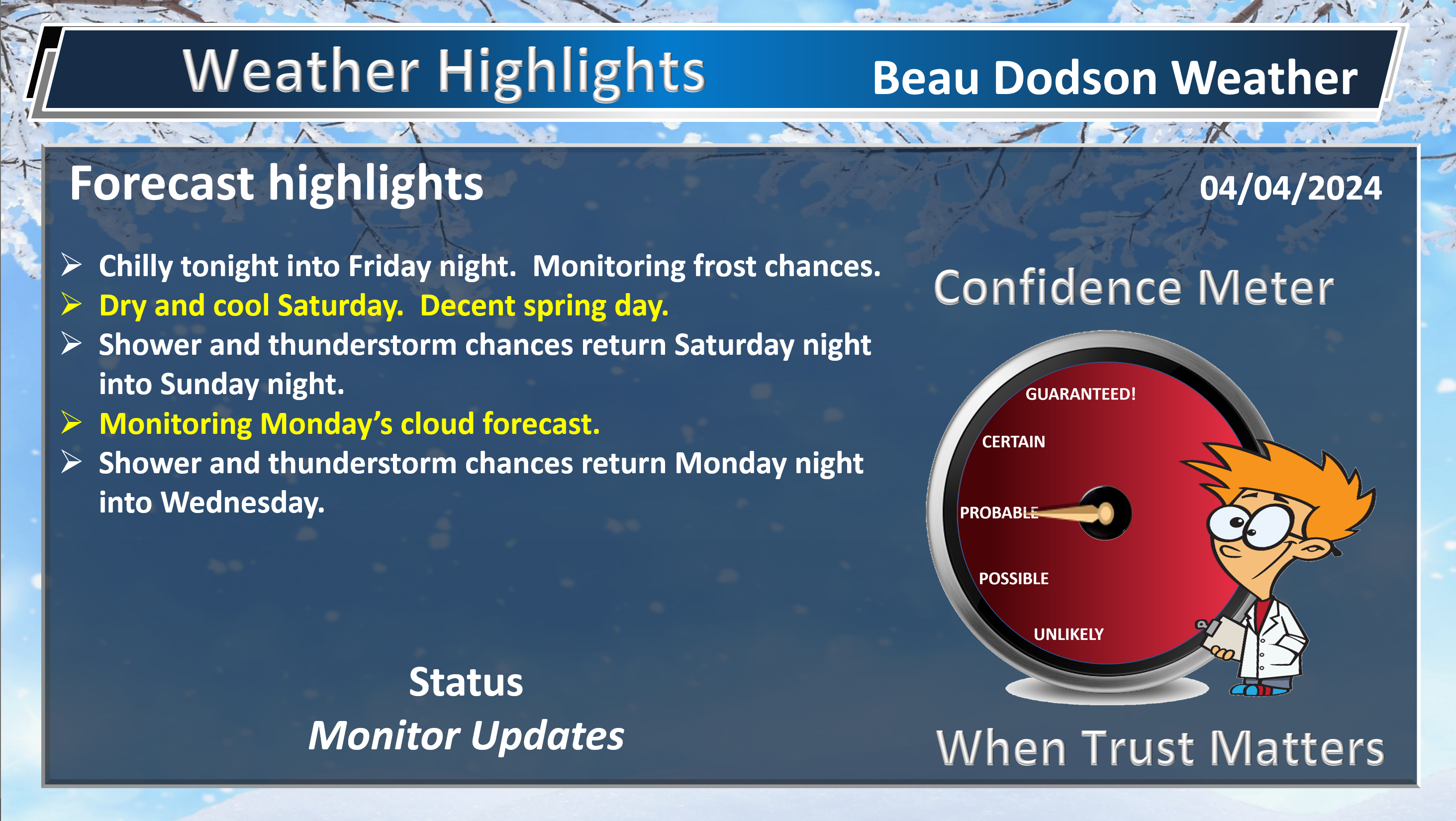
-
- Chilly nights. Frost chances.
- Nice Saturday.
- Shower and thunderstorm chances Saturday night into Sunday night.
- Watching Monday’s eclipse forecast. Some clouds, but how much cloud cover?
- Shower and thunderstorm chances Monday night into Wednesday.
Weather advice:
Do you have any suggestions or comments? Email me at beaudodson@usawx.com
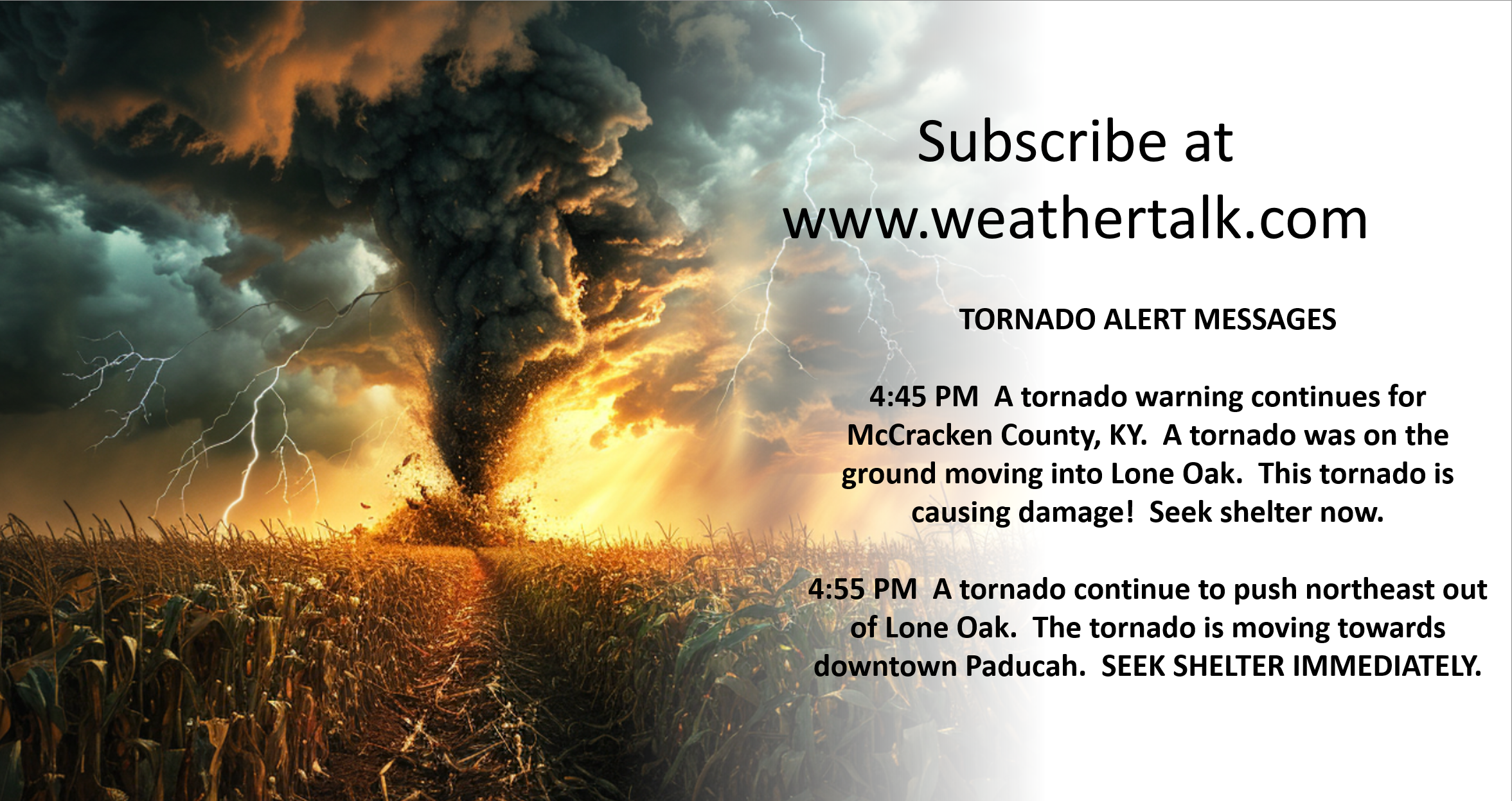
Make sure you have three to five ways of receiving your severe weather information.
Weather Talk is one of those ways.
.
Beau’s Forecast Discussion
Good morning, everyone.
We are waking up to some clouds and chilly temperatures. Clouds are keeping the temperatures from dropping even lower.
Here were the 6 am temperatures.
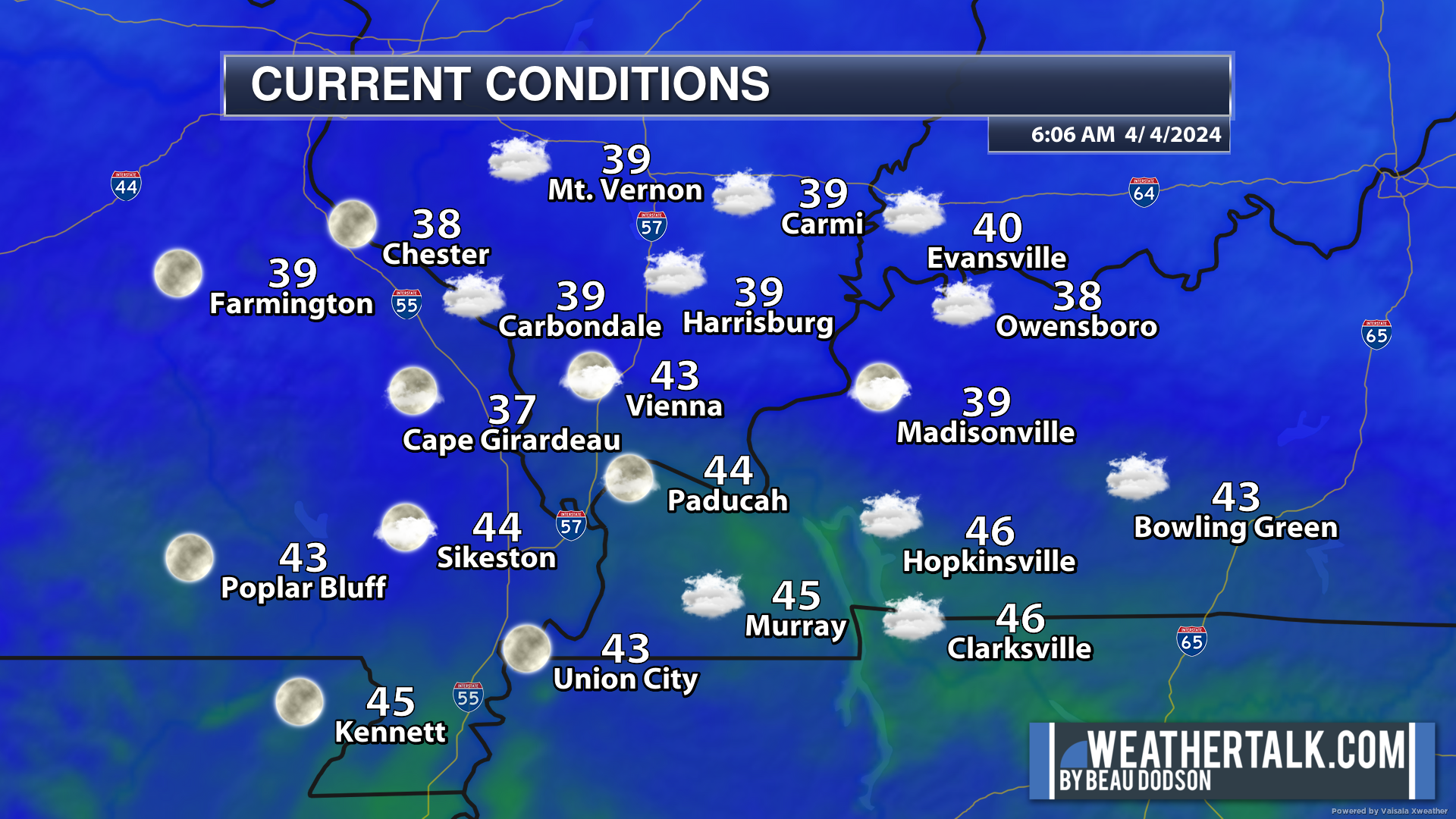
Clouds will be an issue today. Some areas with sun this morning will see more clouds this afternoon. This is all happening around a large upper level low. Clouds are circulating counter-clockwise around the low.
There is a rain/snow mix to our east this morning. Portions of Indiana, Ohio, Kentucky, and West Virginia have experienced rain and snow.
We had thunderstorms with hail and graupel in our region yesterday. Graupel is not the same as sleet or hail. It is closer to the snowflake family.
There were numerous reports of it yesterday. There were also numerous reports of pea to dime size hail. Some lightning, as well. That was all expected as that upper-level low passed overhead. Not an uncommon event.
There were several tornadoes Monday and Tuesday. The NWS continues to do storm surveys. One tornado struck McCracken County near Woodville. It was rated EF1 with 90 mph winds.
It was certainly a busy 48 hours for meteorologists. Two-day events are long. Thankfully, they do not happen all that often.
The bulk of the rain has moved off to the east of our region, but it is not out of the question that someone could report a sprinkle today. Rainfall totals would be trace, at most. Most of the region will simply remain dry.
Any clouds will make it feel cooler with a bit of wind.
Tomorrow into Saturday (during the day) will be dry. A slow warming trend.
A new weather system arrives Saturday night into Sunday night. Another system arrives Monday night into Tuesday. These systems will bring additional shower and thunderstorm chances. At this time, it does not appear that severe weather will be a concern. As always, monitor updates.
As far as the eclipse goes, we are concerned about some clouds. The only question is how much cloud cover. We will be in-between the Sunday and Tuesday system.
I can’t rule out clouds causing issues with the eclipse. I will need to monitor clouds. I currently have the forecast as dry with partly cloudy sky conditions. Rain chances will hold off until Monday night/Tuesday.
It will warm up this weekend with highs around 70 degrees Sunday and in the low to middle 70s Monday. Nice spring weather.
![]()
.
Click here if you would like to return to the top of the page.
This outlook covers southeast Missouri, southern Illinois, western Kentucky, and far northwest Tennessee.

.
Today’s Storm Prediction Center’s (SPC) Severe Weather Outlook
Light green is where thunderstorms may occur but should be below severe levels.
Dark green is a level one risk. Yellow is a level two risk. Orange is a level three (enhanced) risk. Red is a level four (moderate) risk. Pink is a level five (high) risk.
One is the lowest risk. Five is the highest risk.
A severe storm is one that produces 58 mph wind or higher, quarter or larger size hail, and/or a tornado.
Explanation of tables. Click here.
Day One Severe Weather Outlook

Day One Severe Weather Outlook. Zoomed in on our region.

.
Day One Tornado Probability Outlook

Day One Regional Tornado Outlook. Zoomed in on our region.

.
Day One Large Hail Probability Outlook

Day One Regional Hail Outlook. Zoomed in on our region.

.
Day One High wind Probability Outlook

Day One Regional Wind Outlook. Zoomed in on our region.

.
Tomorrow’s severe weather outlook. Day two outlook.

Day Two Outlook. Zoomed in on our region.

.
Day Three Severe Weather Outlook

.

.
The images below are from NOAA’s Weather Prediction Center.
24-hour precipitation outlook..
 .
.
.
48-hour precipitation outlook.
. .
.
![]()
_______________________________________
.

Click here if you would like to return to the top of the page.
Again, as a reminder, these are models. They are never 100% accurate. Take the general idea from them.
What should I take from these?
- The general idea and not specifics. Models usually do well with the generalities.
- The time-stamp is located in the upper left corner.
.
What am I looking at?
You are looking at computer model data. Meteorologists use many different models to forecast the weather.
Occasionally, these maps are in Zulu time. 12z=7 AM. 18z=1 PM. 00z=7 PM. 06z=1 AM
Green represents light rain. Dark green represents moderate rain. Yellow and orange represent heavier rain.
.
This animation is the GFS Model.
Occasionally, these maps are in Zulu time. 12z=7 AM. 18z=1 PM. 00z=7 PM. 06z=1 AM
Double click images to enlarge them. Blue is snow. Pink is a wintry mix. Green is rain.
.
This animation is the NAM Model.
Occasionally, these maps are in Zulu time. 12z=7 AM. 18z=1 PM. 00z=7 PM. 06z=1 AM
Double click images to enlarge them.
.
This animation is the HRRR Model.
Green is rain. Yellow and orange are heavier rain. Pink is a wintry mix. Blue is snow. Dark blue is heavier snow.
Occasionally, these maps are in Zulu time. 12z=7 AM. 18z=1 PM. 00z=7 PM. 06z=1 AM
Double click images to enlarge them.
.
This animation is the EC Model.
Green is rain. Yellow and orange are heavier rain. Pink is a wintry mix. Blue is snow. Dark blue is heavier snow.
Occasionally, these maps are in Zulu time. 12z=7 AM. 18z=1 PM. 00z=7 PM. 06z=1 AM
Double click images to enlarge them.
..![]()

.
Click here if you would like to return to the top of the page.
.Average high temperatures for this time of the year are around 62 degrees.
Average low temperatures for this time of the year are around 40 degrees.
Average precipitation during this time period ranges from 0.60″ to 1.20″
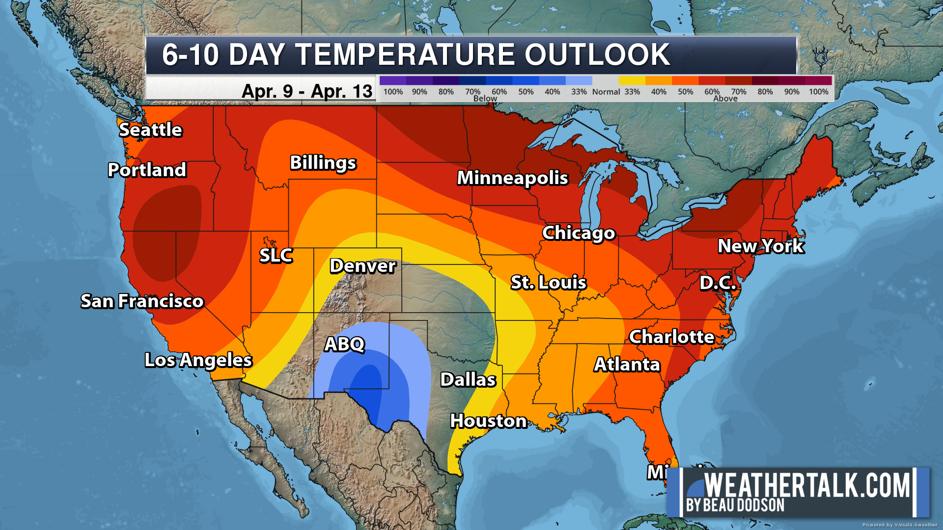
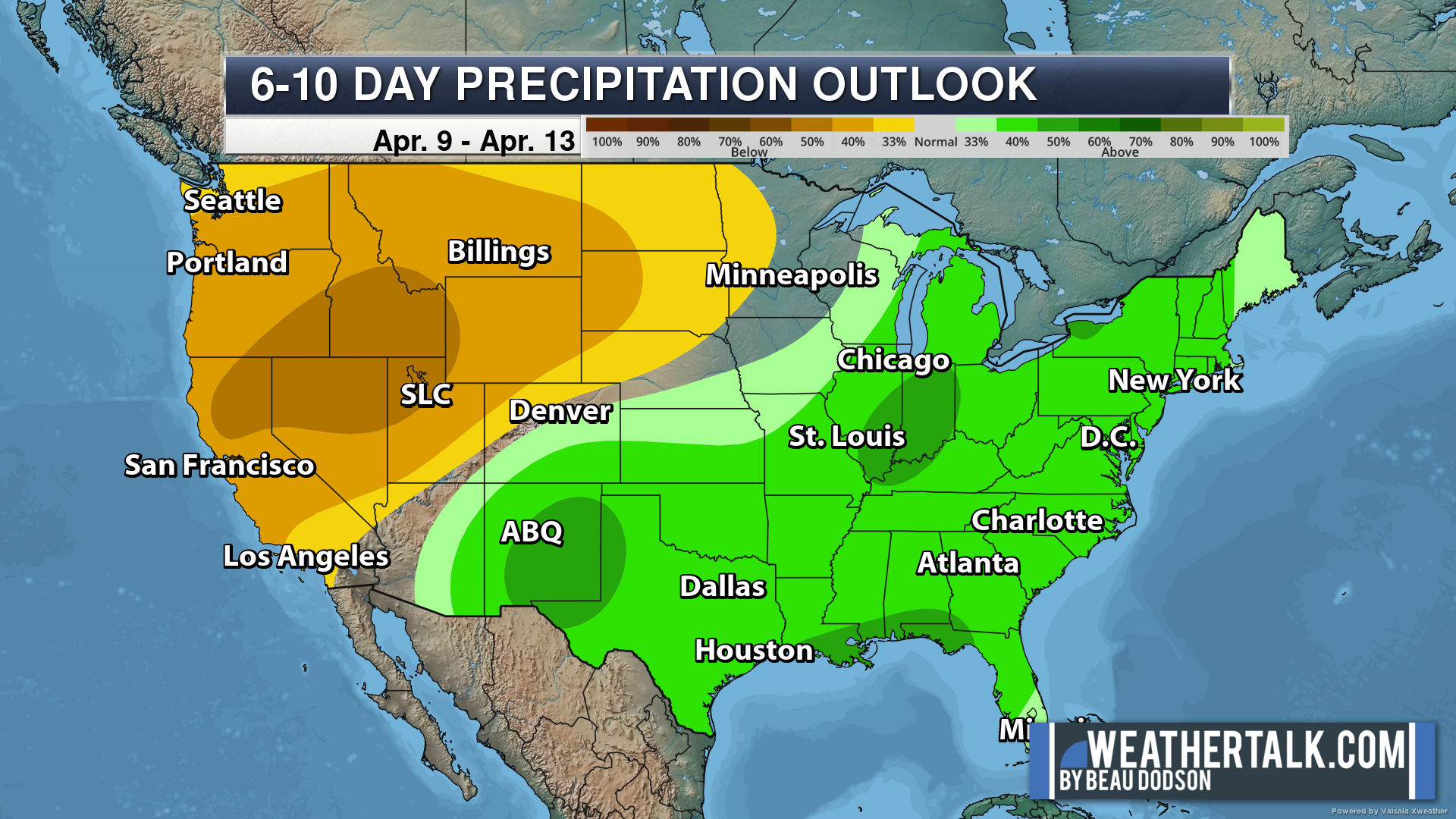
Six to Ten Day Outlook.
Blue is below average. Red is above average. The no color zone represents equal chances.
Average highs for this time of the year are in the lower 60s. Average lows for this time of the year are in the lower 40s.
Green is above average precipitation. Yellow and brown favors below average precipitation. Average precipitation for this time of the year is around one inch per week.
.

Average low temperatures for this time of the year are around 41 degrees.
Average precipitation during this time period ranges from 0.60″ to 1.20″
.
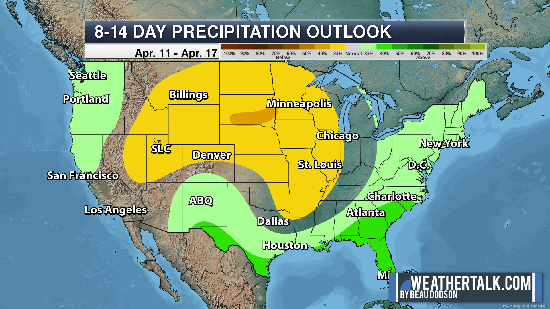
Eight to Fourteen Day Outlook.
Blue is below average. Red is above average. The no color zone represents equal chances.
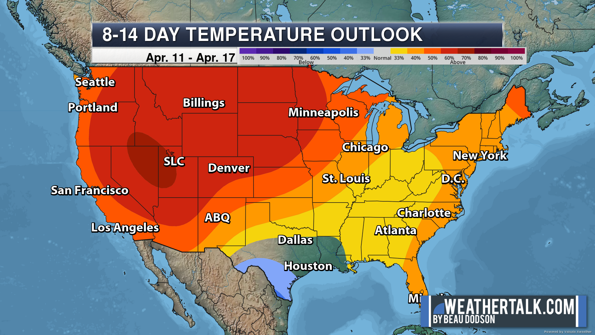
Green is above average precipitation. Yellow and brown favors below average precipitation. Average precipitation for this time of the year is around one inch per week.
.
![]()
The app is for subscribers. Subscribe at www.weathertalk.com/welcome then go to your app store and search for WeatherTalk
Subscribers, PLEASE USE THE APP. ATT and Verizon are not reliable during severe weather. They are delaying text messages.
The app is under WeatherTalk in the app store.

Apple users click here

Android users click here
.

Radars and Lightning Data
Interactive-city-view radars. Clickable watches and warnings.
https://wtalk.co/B3XHASFZ
If the radar is not updating then try another one. If a radar does not appear to be refreshing then hit Ctrl F5. You may also try restarting your browser.
Backup radar site in case the above one is not working.
https://weathertalk.com/morani
Regional Radar
https://imagery.weathertalk.com/prx/RadarLoop.mp4
** NEW ** Zoom radar with chaser tracking abilities!
ZoomRadar
Lightning Data (zoom in and out of your local area)
https://wtalk.co/WJ3SN5UZ
Not working? Email me at beaudodson@usawx.com
National map of weather watches and warnings. Click here.
Storm Prediction Center. Click here.
Weather Prediction Center. Click here.
.

Live lightning data: Click here.
Real time lightning data (another one) https://map.blitzortung.org/#5.02/37.95/-86.99
Our new Zoom radar with storm chases
.
.

Interactive GOES R satellite. Track clouds. Click here.
GOES 16 slider tool. Click here.
College of DuPage satellites. Click here
.

Here are the latest local river stage forecast numbers Click Here.
Here are the latest lake stage forecast numbers for Kentucky Lake and Lake Barkley Click Here.
.
.
Find Beau on Facebook! Click the banner.


 .
.