The latest update will be posted here at the top of Beau’s severe weather blog. I may delete old posts if it helps speed up the page.
Click on the words below to subscribe
.
April 28, 2021
Concerns:
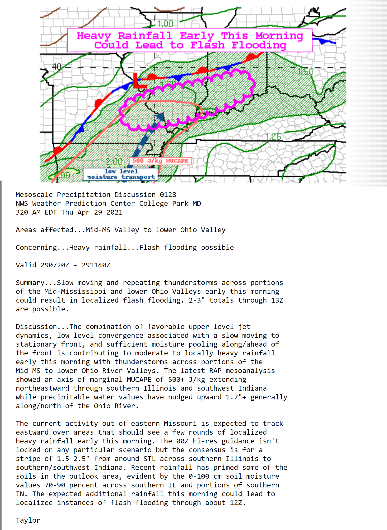
Locally heavy rain is likely today and Thursday. Some locations could top four inches of rain. The area of highest concern is southeast Missouri and southern Illinois.
There is a higher than normal amount of uncertainty about the Missouri Bootheel into extreme southern Illinois, western Kentucky, and northwest Tennessee. There are indications that there could be a band of heavy rain there, as well. Confidence, however, is not as high as Missouri and much of southern Illinois. Especially the northern half of both areas.
Make sure your Beau Dodson Weather app is working. Need to download the app?
.
Key Points
- Thunderstorm activity will increase today into Thursday.
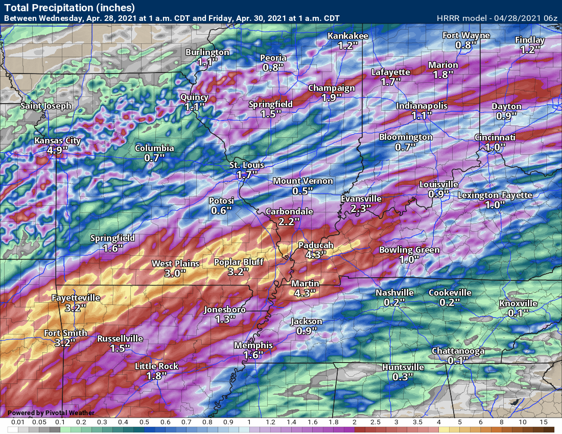
- The primary concern will heavy rain. Potentially very heavy rain in some areas. Guidance indicates a couple of bands of rain in the 3 to 5 inch rain. This would most likely occur across southeast Missouri and southern Illinois, but other areas should monitor for adjustments in the placement of the heaviest bands.
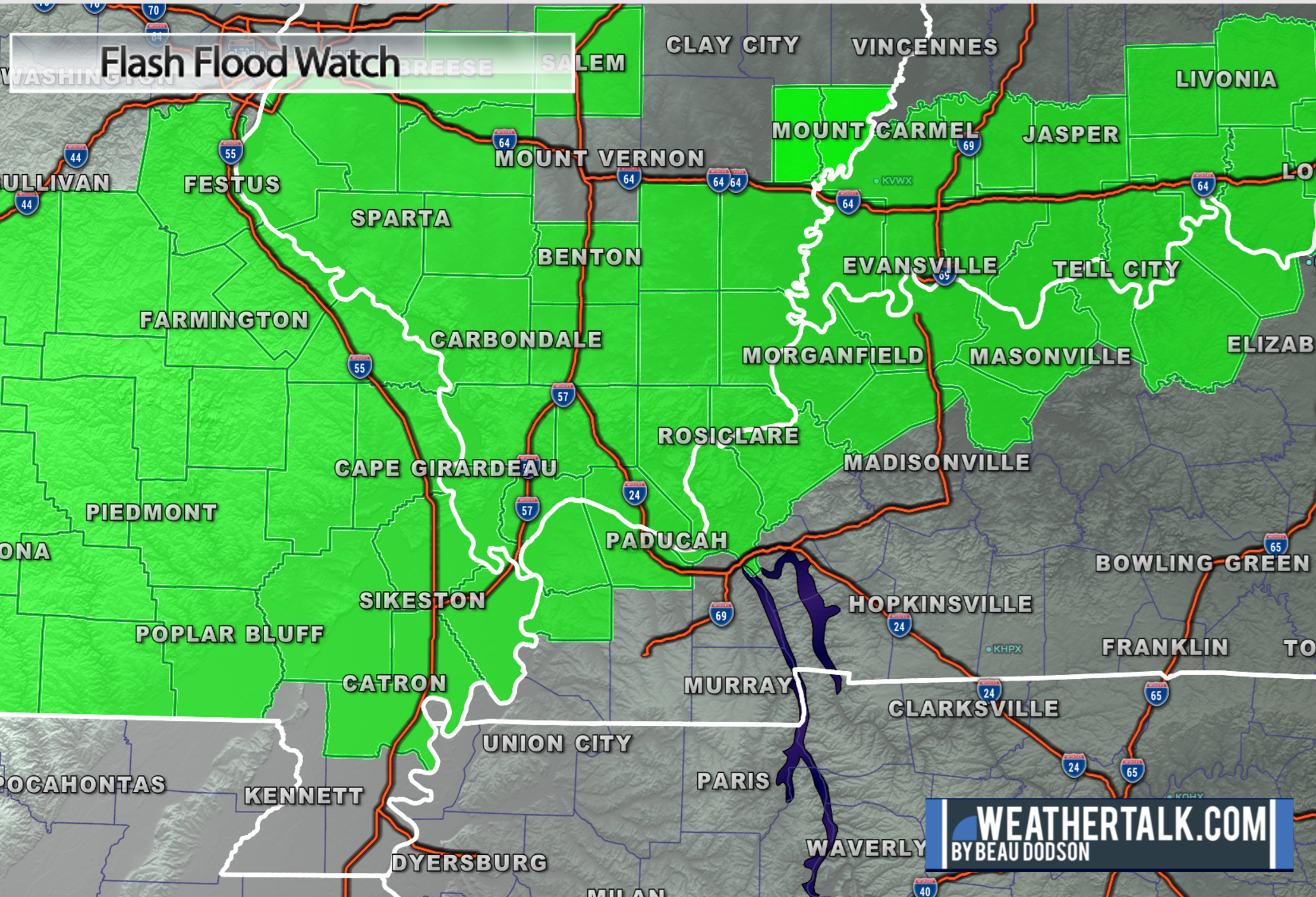
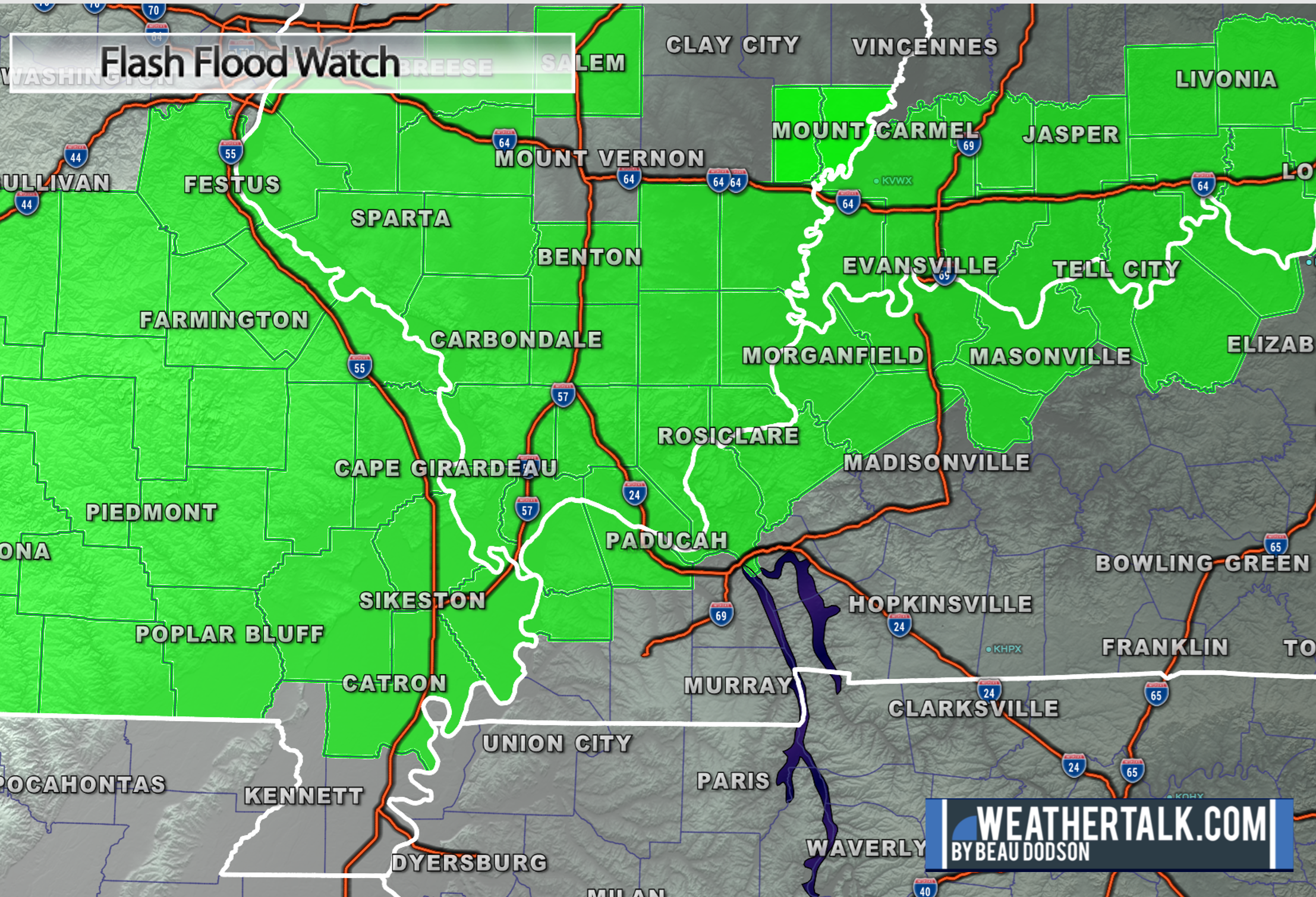
- Flash flood watches have been issued for portions of the region.
- A few storms could produce wind damage Wednesday and Thursday. Overall, the risk of severe weather appears to be lower-end, but not zero. This is a change from previous forecasts.
- Have your Beau Dodson Weather app on. Check it. Make sure you have not logged out of the app.
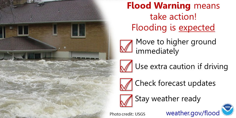
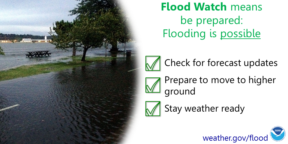
- Remember, a watch means to monitor updates. A warning means to seek shelter. A warning is a higher threat.
.
Call to action.
Monitor updated weather forecasts.
Have a safety plan.
Make sure you are using the Beau Dodson Weather Talk app. Download it from the app store. It is under Weather Talk.
The app is for subscribers (please log into your account and make sure your payment has been updated. We have a large number of declined cards and PayPal payments.
Subscribe at www.weathertalk.com/welcome then go to your app store and search for WeatherTalk. Apple users click here. Android users click here
.
1 PM
Low risk of additional severe storms. I believe we are finished with that.
The flood watch has expired.
.
9:35 AM
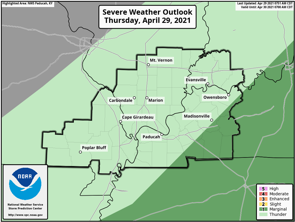
SPC downgraded us to a level one severe risk. That is the lowest risk. The dark green zone. Light green is where general sub-severe storms are possible.
8 AM
FLASH FLOOD WATCH IS CANCELLED...

THE FLASH FLOOD WATCH FOR PORTIONS OF SOUTHERN ILLINOIS AND
SOUTHEAST MISSOURI, INCLUDING THE FOLLOWING AREAS, IN SOUTHERN
ILLINOIS, EDWARDS, FRANKLIN, HAMILTON, JACKSON, JEFFERSON, PERRY IL,
WABASH AND WAYNE IL. IN SOUTHEAST MISSOURI, BOLLINGER, BUTLER, CAPE
GIRARDEAU, CARTER, PERRY MO, RIPLEY AND WAYNE MO HAS BEEN CANCELLED.

THE FLOOD WATCH IS CANCELLED. ANY LINGERING RAINFALL TODAY IS NOT
EXPECTED TO CAUSE CONCERN FOR FLOODING IN THIS AREA.

$$

ILZ083-085>094-INZ081-082-085>088-KYZ003>005-007-010-014-015-018>020-
MOZ110>112-114-292015-
/O.CON.KPAH.FF.A.0003.000000T0000Z-210430T0000Z/
/00000.0.ER.000000T0000Z.000000T0000Z.000000T0000Z.OO/
WHITE-WILLIAMSON-SALINE-GALLATIN-UNION-JOHNSON-POPE-HARDIN-ALEXANDER-
PULASKI-MASSAC-GIBSON-PIKE-POSEY-VANDERBURGH-WARRICK-SPENCER-
CARLISLE-BALLARD-MCCRACKEN-LIVINGSTON-CRITTENDEN-UNION KY-WEBSTER-
HENDERSON-DAVIESS-MCLEAN-STODDARD-SCOTT-MISSISSIPPI-NEW MADRID-
INCLUDING THE CITIES OF CALHOUN, PETERSBURG, SHAWNEETOWN,
EVANSVILLE, VIENNA, METROPOLIS, POSEYVILLE, HERRIN, HARRISBURG,
MOUND CITY, CARMI, JONESBORO, HENDERSON, BARDWELL, PADUCAH,
SMITHLAND, FORT BRANCH, BOONVILLE, CHARLESTON, NEW MADRID, GOLCONDA,
CAIRO, SIKESTON, BLOOMFIELD, MORGANFIELD, OWENSBORO, MARION,
WICKLIFFE, ROCKPORT, ELIZABETHTOWN, AND DIXON
714 AM CDT THU APR 29 2021

...FLASH FLOOD WATCH REMAINS IN EFFECT UNTIL 7 PM CDT THIS EVENING...

THE FLASH FLOOD WATCH CONTINUES FOR

* PORTIONS OF SOUTHERN ILLINOIS...SOUTHWEST INDIANA...WESTERN
  KENTUCKY AND SOUTHEAST MISSOURI, INCLUDING THE FOLLOWING AREAS, IN
  SOUTHERN ILLINOIS, ALEXANDER, GALLATIN, HARDIN, JOHNSON, MASSAC,
  POPE, PULASKI, SALINE, UNION, WHITE AND WILLIAMSON. IN SOUTHWEST
  INDIANA, GIBSON, PIKE, POSEY, SPENCER, VANDERBURGH AND WARRICK. IN
  WESTERN KENTUCKY, BALLARD, CARLISLE, CRITTENDEN, DAVIESS,
  HENDERSON, LIVINGSTON, MCCRACKEN, MCLEAN, UNION KY AND WEBSTER. IN
  SOUTHEAST MISSOURI, MISSISSIPPI, NEW MADRID, SCOTT AND STODDARD.

* UNTIL 7 PM CDT THIS EVENING

* THE POTENTIAL FOR MODERATE TO HEAVY RAINFALL CONTINUES THROUGH
  MIDDAY. ADDITIONAL RAINFALL TOTALS OF ONE HALF TO ONE INCH REMAIN
  POSSIBLE. LOCALLY HIGHER AMOUNTS CANNOT BE RULED OUT. THIS WATCH
  IS GENERALLY IN AFFECT FOR LOCATIONS ALONG AND SOUTH OF A LINE
  FROM PETERSBURG, INDIANA TO MARION, ILLINOIS TO DEXTER, MISSOURI,
  AND ALONG AND NORTH OF A LINE EXTENDING FROM NEW MADRID, MISSOURI
  TO PADUCAH, KENTUCKY TO CALHOUN, KENTUCKY.

* IN ADDITION TO THE FLASH FLOOD POTENTIAL OF URBAN AND RURAL AREAS,
  SOME MAIN STEM RIVERS MAY ALSO BE AFFECTED WITH TIME.
5:35 AM
SPECIAL WEATHER STATEMENT
NATIONAL WEATHER SERVICE MEMPHIS TN
532 AM CDT THU APR 29 2021

TNZ003-004-019>022-048-051-291100-
CARROLL TN-WEAKLEY TN-BENTON TN-CROCKETT TN-LAUDERDALE TN-HENRY TN-
DYER TN-GIBSON TN-
532 AM CDT THU APR 29 2021

...A SIGNIFICANT WEATHER ADVISORY HAS BEEN ISSUED UNTIL 600 AM CDT
FOR...

CARROLL COUNTY IN WESTERN TENNESSEE...
WEAKLEY COUNTY IN WESTERN TENNESSEE...
BENTON COUNTY IN WESTERN TENNESSEE...
NORTHERN CROCKETT COUNTY IN WESTERN TENNESSEE...
EAST CENTRAL LAUDERDALE COUNTY IN WESTERN TENNESSEE...
HENRY COUNTY IN WESTERN TENNESSEE...
SOUTHEASTERN DYER COUNTY IN WESTERN TENNESSEE...
GIBSON COUNTY IN WESTERN TENNESSEE...

AT 531 AM CDT...STRONG THUNDERSTORMS PRODUCING PEA SIZE HAIL OR
LARGER AND WINDS AT LEAST 40 MPH WAS LOCATED ALONG A LINE EXTENDING
FROM LATHAM TO DYER TO NEAR CHESTNUT BLUFF. MOVEMENT WAS EAST AT
50 MPH.

DANGEROUS CLOUD TO GROUND LIGHTNING IS ALSO POSSIBLE WITH THIS
THUNDERSTORM.

PEOPLE IN CARROLL...WEAKLEY...BENTON...NORTHERN CROCKETT...EAST
CENTRAL LAUDERDALE...HENRY...SOUTHEASTERN DYER AND GIBSON COUNTIES
SHOULD MONITOR THIS STORM CLOSELY.
4:45 AM
| MEG issues A SIGNIFICANT WEATHER ADVISORY HAS BEEN ISSUED UNTIL 545 AM CDT FOR for Crockett, Dyer, Gibson, Lake, Lauderdale, Obion, Weakley [TN] and Pemiscot [MO] and Mississippi [AR] till 5:45 AM CDT |
SPECIAL WEATHER STATEMENT
NATIONAL WEATHER SERVICE MEMPHIS TN
440 AM CDT THU APR 29 2021

ARZ028-MOZ115-TNZ001>003-019-020-048-051-291045-
MISSISSIPPI AR-PEMISCOT MO-WEAKLEY TN-LAKE TN-CROCKETT TN-
LAUDERDALE TN-OBION TN-DYER TN-GIBSON TN-
440 AM CDT THU APR 29 2021

...A SIGNIFICANT WEATHER ADVISORY HAS BEEN ISSUED UNTIL 545 AM CDT
FOR...

NORTHEASTERN MISSISSIPPI COUNTY IN EASTERN ARKANSAS...
CENTRAL PEMISCOT COUNTY IN SOUTHEASTERN MISSOURI...
WESTERN WEAKLEY COUNTY IN WESTERN TENNESSEE...
LAKE COUNTY IN WESTERN TENNESSEE...
NORTHWESTERN CROCKETT COUNTY IN WESTERN TENNESSEE...
NORTHEASTERN LAUDERDALE COUNTY IN WESTERN TENNESSEE...
OBION COUNTY IN WESTERN TENNESSEE...
DYER COUNTY IN WESTERN TENNESSEE...
WESTERN GIBSON COUNTY IN WESTERN TENNESSEE...

AT 439 AM CDT...STRONG THUNDERSTORMS PRODUCING PENNY TO NICKEL SIZE
HAIL AND WINDS 35 TO 45 MPH WAS LOCATED ALONG A LINE EXTENDING FROM
NEAR MARSTON TO CARUTHERSVILLE TO NEAR BLYTHEVILLE. MOVEMENT WAS EAST
AT 50 MPH.

PEOPLE IN NORTHEASTERN MISSISSIPPI...CENTRAL PEMISCOT...WESTERN
WEAKLEY...LAKE...NORTHWESTERN CROCKETT...NORTHEASTERN LAUDERDALE...
OBION...DYER AND WESTERN GIBSON COUNTIES SHOULD MONITOR THIS STORM
CLOSELY.
4:40 AM
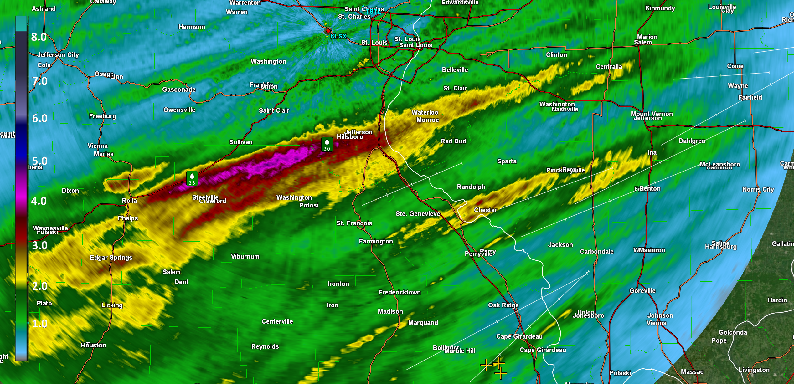
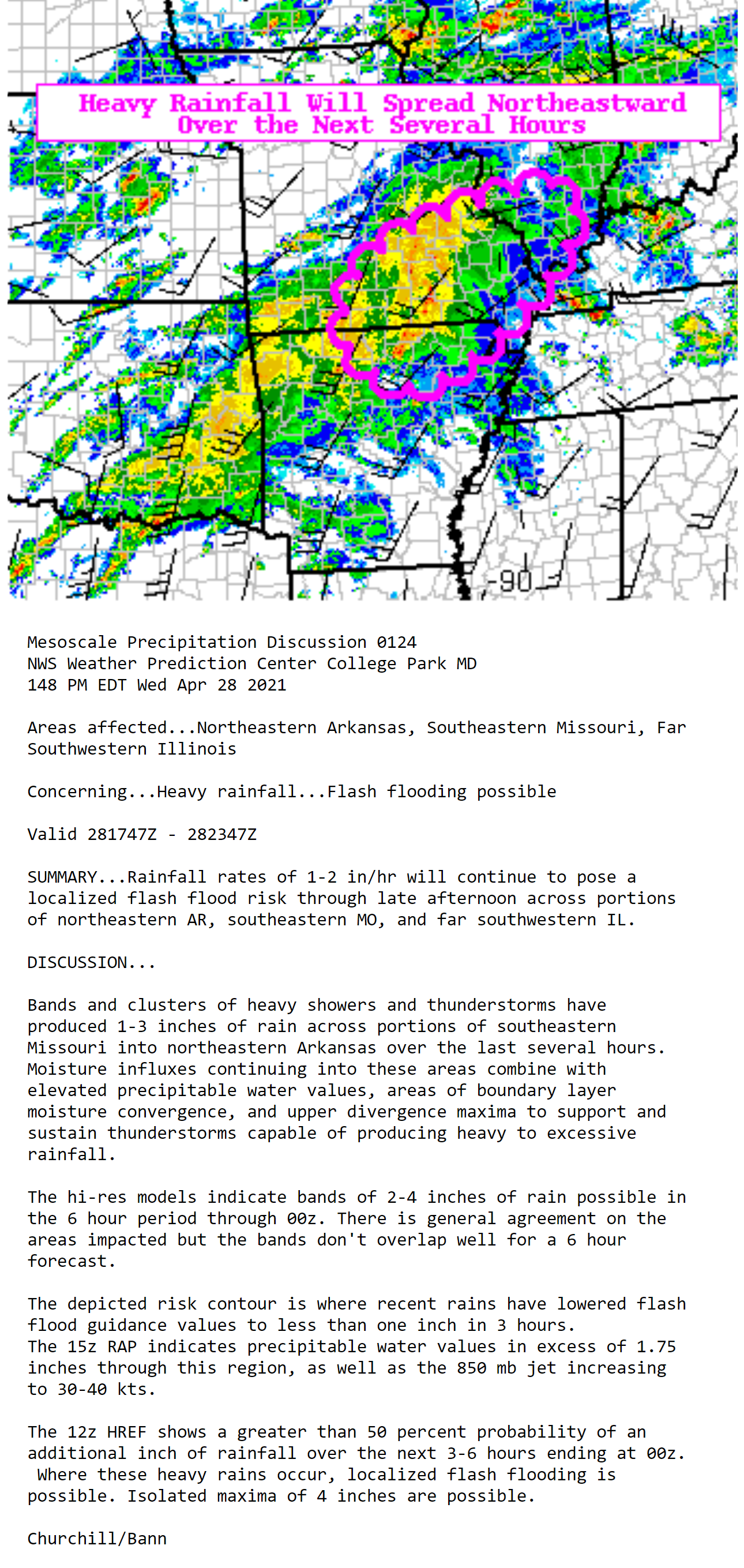
Check out this heavy band of rain that formed last night. Some locations topped 4 inches of rain!
.
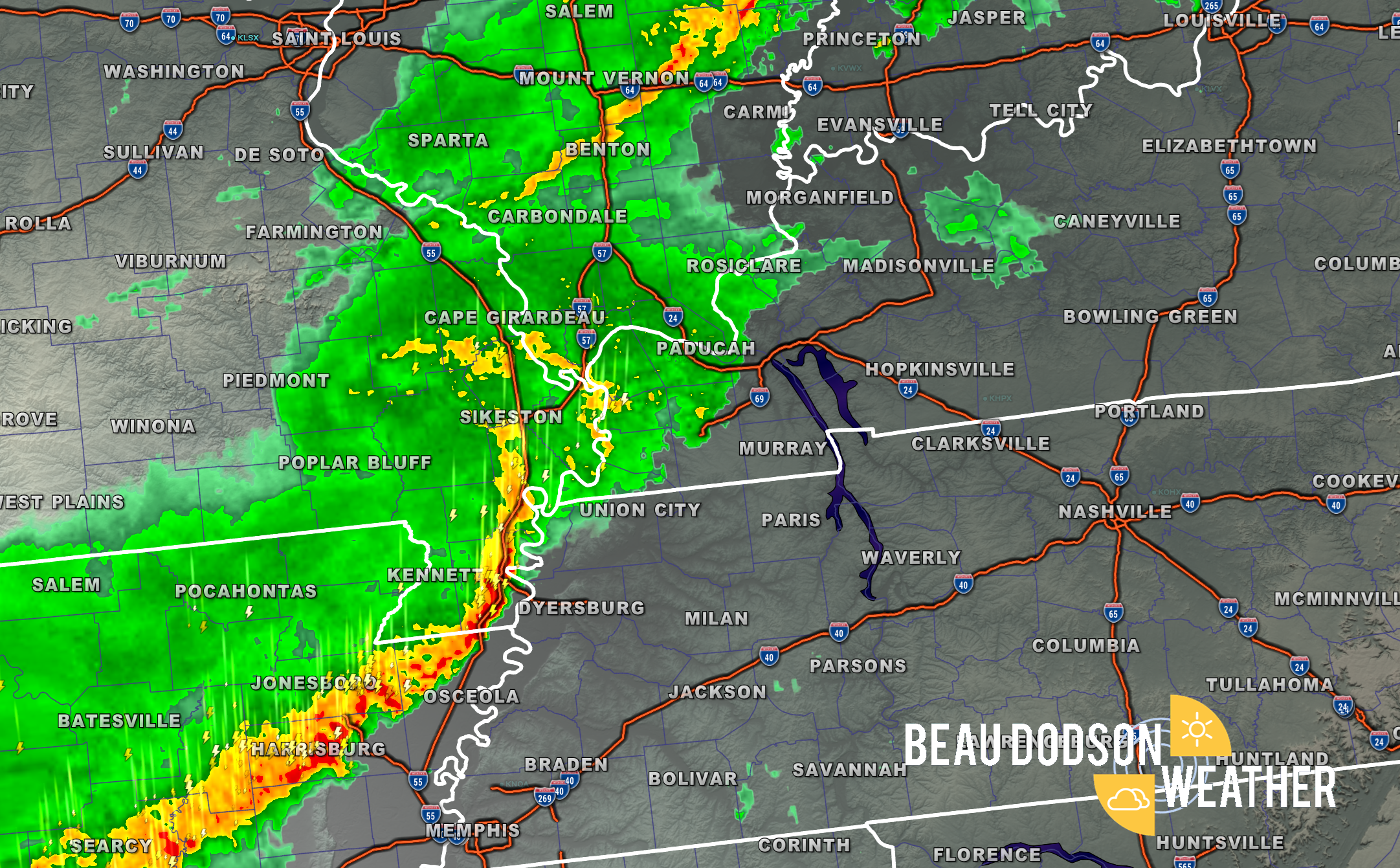
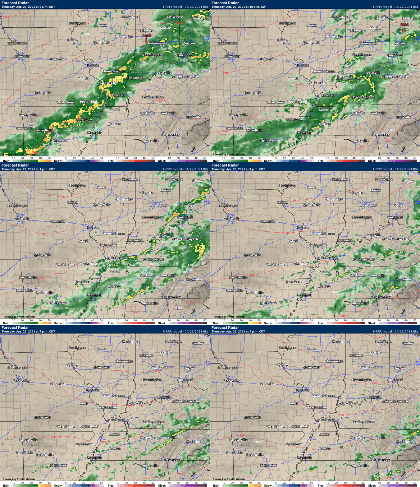
This line of storms is the main concern this morning.
.
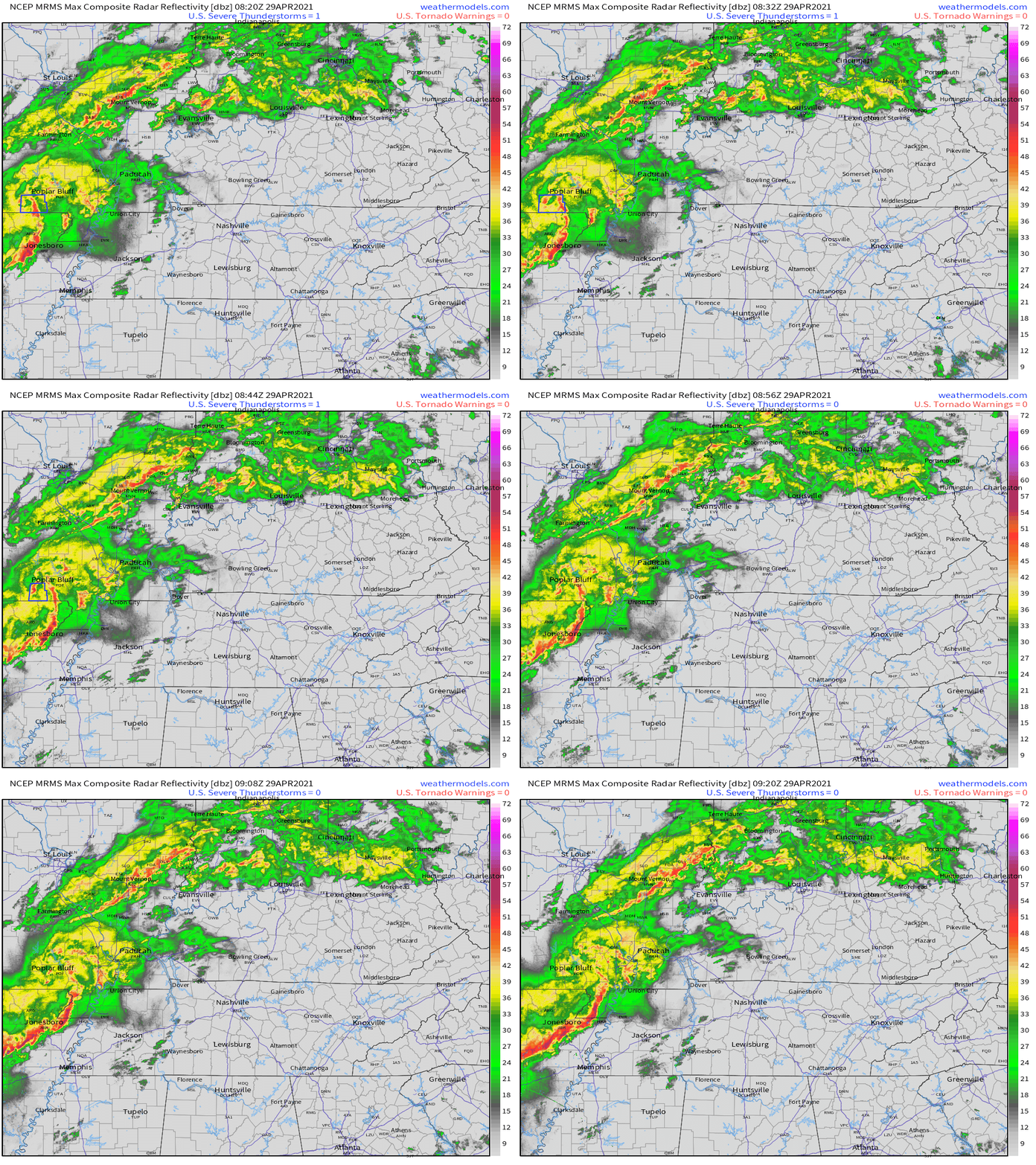
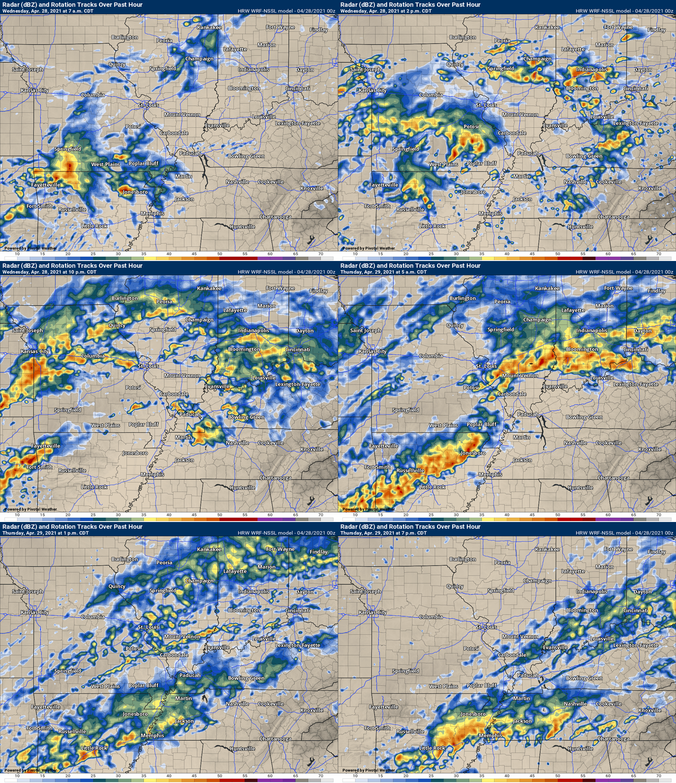
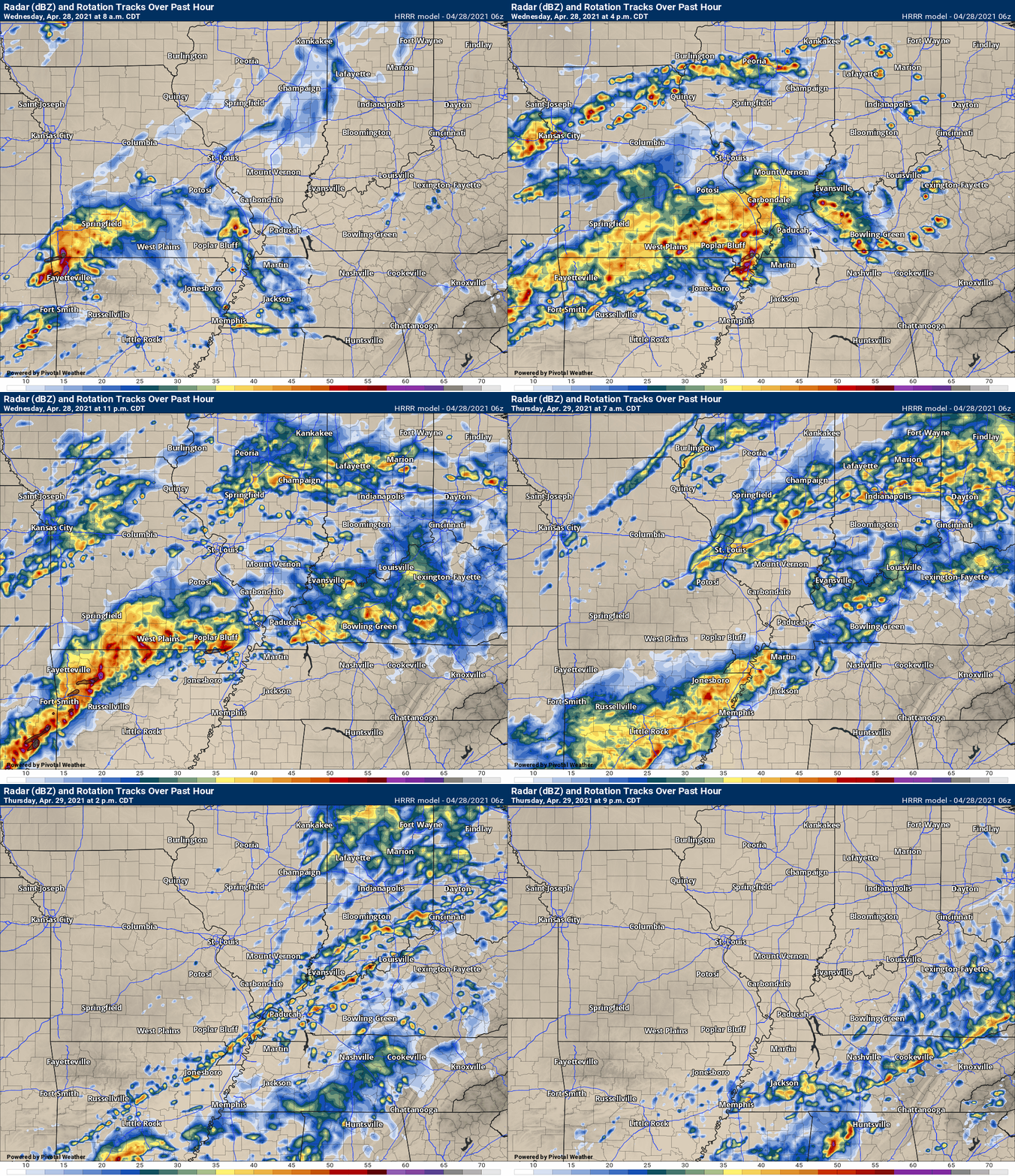
You can see the Hrrr model. The main line moves east fairly rapidly. Some storms could redevelop behind the line. IF that happens, then they could be severe with high winds.
Something that I will be monitoring today.
Otherwise, very heavy downpours with this heavier line of storms. This morning.
.
4:30 AM
SPECIAL WEATHER STATEMENT
NATIONAL WEATHER SERVICE PADUCAH KY
431 AM CDT THU APR 29 2021

KYZ001>004-MOZ112-114-291030-
CARLISLE KY-BALLARD KY-FULTON KY-HICKMAN KY-NEW MADRID MO-
MISSISSIPPI MO-
431 AM CDT THU APR 29 2021

...SIGNIFICANT WEATHER ADVISORY FOR FULTON...HICKMAN...CARLISLE...
SOUTHEASTERN BALLARD...MISSISSIPPI AND EASTERN NEW MADRID COUNTIES
UNTIL 530 AM CDT...

AT 430 AM CDT, DOPPLER RADAR WAS TRACKING STRONG THUNDERSTORMS ALONG
A LINE EXTENDING FROM MATTHEWS TO NEAR NEW MADRID TO NEAR HAYTI.
MOVEMENT WAS EAST, NORTHEAST AT 45 MPH.

WINDS 35 TO 50 MPH WILL BE POSSIBLE WITH THESE STORMS.

LOCATIONS IMPACTED INCLUDE...
CHARLESTON, EAST PRAIRIE, NEW MADRID, FULTON, HICKMAN, CLINTON,
LILBOURN, BARDWELL, WICKLIFFE, TOWOSAHGY STATE HISTORIC SITE, BIG OAK
TREE STATE PARK, HUNTER-DAWSON STATE HISTORIC SITE, MATTHEWS,
MARSTON, HOWARDVILLE, WYATT, ANNISTON, CAYCE, DORENA AND FULGHAM.
PAH issues SIGNIFICANT WEATHER ADVISORY FOR FULTON, HICKMAN, CARLISLE, SOUTHEASTERN BALLARD, MISSISSIPPI AND EASTERN NEW MADRID COUNTIES UNTIL 530 AM CDT for Fulton, Hickman, Carlisle, Ballard [KY] and Mississippi, New Madrid [MO] till 5:30 AM CDT
.
2:30 AM Thursday
Click image to enlarge
.
7:35 PM
.
Certainly is possible.
WE ARE DONE with severe weather for now.
.
I will keep an eye on it. Could be very early for some areas. 1 AM to 11 AM should be a line moving west to east.
Heavy rain is the main concern.
Okay, I am taking a break. Will post more if necessary.
Otherwise, here are the radars and lightning trackers
Radars and Lightning Data
.
7:15 PM
Henry County.
Radar now shows the rotation is nearing Paris Landing State Park. Moving east and slightly northeast at 20 to 30 mph. It will move between Oak Hill, Tennessee and the southern county line. It will then move out of your county. That will end the threat.
For now, if you are in the path of this tornado…seek shelter.
This storm has a history of producing tornadoes. Seek shelter if you are in the path of the storm.
.
7:05 PM
Henry County.
Radar now shows the rotation is northeast of Nobles, Tennessee. Moving is a bit more northeast of east. It will approach areas like Oak Hill over the next 15 to 20 minutes.
Eastern Henry County should seek shelter until this storm ends.
This storm has a history of producing tornadoes. Seek shelter if you are in the path of the storm.
.
6:52 PM
Henry County.
Radar now shows strong rotation nearing Nobles. If you are in or near Nobles, Tennessee, then seek shelter until this storm passes. There have been reports of a tornado on the ground with this storm.
It is moving E NE. Remember, the warning zone is in or NEAR Nobles.
.
6:46 PM
Henry County.
We have received reports of a tornado on the ground with this thunderstorm. Seek shelter if you are in the path. The strongest rotation is now near Whitlock moving towards Noble. If you are in or NEAR this area then you are in the danger zone.
.
6:45 PM
Calloway County.
The area of rotation has weakened considerably. The severe threat is currently low.
Thunderstorms, some with heavy rain, will continue to move through the county with a low risk of 50 mph wind gusts. Lightning, of course.
A tornadic supercell continues to move through Henry County, TN. Some of you in Calloway are receiving cell phone tornado warnings. This is based on cell tower location. There is not a tornado warning for Calloway County..
6:40 PM
Henry County.
Radar shows a possible tornado near Whitlock, TN. This storm is moving east at 25 mph. If you are in or NEAR this area then seek shelter until this storm passes.
This storm has a history of wind damage.
.
6:38 PM
Lyon, Todd, Caldwell Counties.
Thunderstorms are approaching your area. Some of these storms could produce an inch of rain in 15 minutes. Some of the storms may also produce isolated 50 mph wind gusts that could knock some branches down.
Radar Link: Interactive local city-view radars & regional radars.
You will find clickable warning and advisory buttons on the local city-view radars.
Backup radar site in case the above one is not working.
https://weathertalk.com/morani
New ZOOM radar (with storm chasers)
https://wtalk.co/AVWG7GM7
Regional Radar
https://imagery.weathertalk.com/prx/RadarLoop.mp4
Real time lightning tracker system two.
https://map.blitzortung.org/#5.02/37.95/-86.99
Lightning Data (zoom in and out of your local area)
https://wtalk.co/WJ3SN5UZ
.
6:34 PM
Calloway and Marshall.
The primary concern is an area of circulation southwest of Murray. It is not tight, but it is there. The NWS has issued a severe thunderstorm warning for the line of storms extending from Marshall County into Calloway. The bulk of the warning zone is in Calloway County.
This storm could produce a short-lived tornado. If you feel threatened by storms, then seek shelter until the line of storms passes your area.
.
6:22 PM
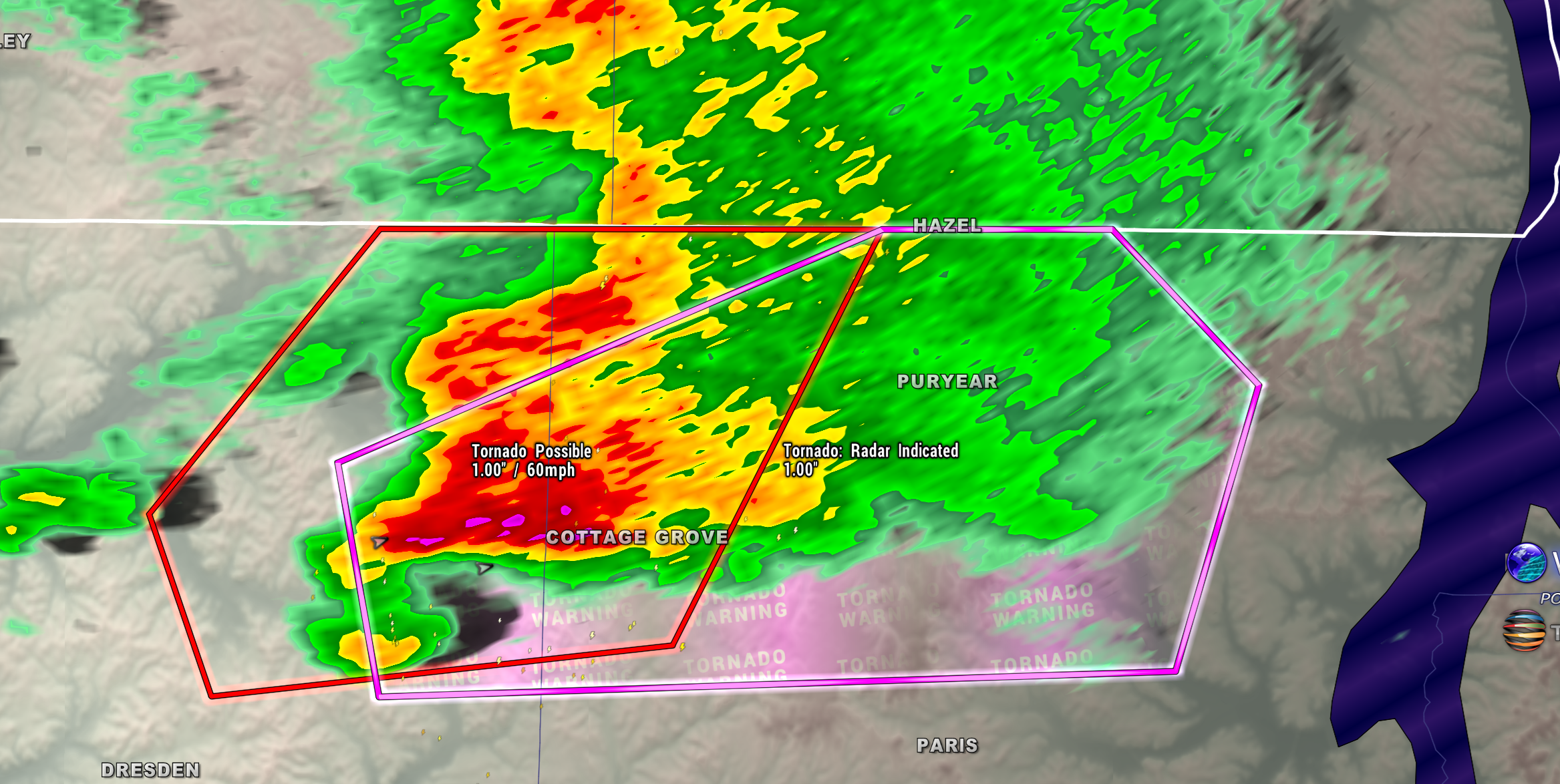
Radar shows the strongest rotation leaving Weakley County and entering the Cottage Grover area of Henry County. The storm is moving E NE at 25 mph.
Seek shelter if you are in the path of this storm. It may produce a tornado. It does have a history of wind damage.
.
6:20 PM
| Local Storm Report by NWS MEG: Union City [Obion Co, TN] trained spotter reports TSTM WND DMG at 05:20 PM CDT — branches greater than a foot in diameter torn from trees. |
6:17 PM
Some of you received a tornado warning from the NWS on your cell phones. Calloway County is currently NOT in the tornado warning.
If that changes, then I will send out a message.
A possible tornado was located in southeast Weakley County moving towards Henry County. For now, it appears this will stay south of Calloway County. I am closely monitoring the storm.
.
6:11 PM
Weakley and Henry Counties.
Radar shows a possible tornado near Dunlap in Weakley County. This storm is moving east northeast at 25 mph. Seek shelter if you are in the path of this possible tornado.
.
5:57 PM
Graves and Marshall Counties.
Intense thunderstorms are moving through Graves County. These storms will eventually push into Marshall County, as well. The heaviest storms are producing one to two inches of rain in less than thirty minutes.
There may also be isolated 55 mph wind gusts. This could cause tree damage.
Seek shelter if you feel threatened by a storm.
.
5:52 PM
Weakley, Henry, and Calloway.
Intense thunderstorms continue to move through Weakley County, TN and will push into at least northwest Henry County over the next 30 minutes.
The storms will also push into Calloway County.
A few of these storms will produce an inch of rain in less than 15 minutes and wind gusts above 50 mph.
Seek shelter if you feel threatened by a storm.
.
5:48 PM
BULLETIN – IMMEDIATE BROADCAST REQUESTED
Severe Thunderstorm Warning
National Weather Service Memphis TN
548 PM CDT Wed Apr 28 2021
The National Weather Service in Memphis has issued a
* Severe Thunderstorm Warning for…
Northern Weakley County in western Tennessee…
Northwestern Henry County in western Tennessee…
* Until 630 PM CDT.
* At 548 PM CDT, a severe thunderstorm was located near Latham, or
near Martin, moving northeast at 35 mph.
.
5:40 PM
| Looks like 1.04″ in a 10 minute period between 510-520 at Hickman mesonet |
.
5:09 PM
Obion and Weakley Counties.
Storms have intensified just a bit in your counties. The strongest storm was in Obion County moving east.
This storm will likely produce winds of 55 mph. There could be some isolated wind damage from this cell.
Torrential rain is falling with these thunderstorms. This could briefly flood roadways.
.
4:33 PM
| PAH issues Flash Flood Warning for Fulton, Hickman [KY] and Mississippi, New Madrid [MO] till 8:30 PM CDT |
4:29 PM
| Storm Report by NWS PAH: 4 SE Patton [Bollinger Co, MO] emergency mngr reports TSTM WND DMG at 03:00 PM CDT — shop roof blown off |
4:16 PM
Alexander and Pulaski.
Radar indicated a rotating storm north of Miller City in Alexander County. This storm is moving east at 30 mph. Occasionally, storms like this can produce short-lived tornadoes.
Be weather aware as these storms move into your area. Seek shelter if you feel threatened by a storm.
.
4:10 PM
Alexander, Pulaski, Ballard, Carlisle, and Hickman Counties.
A line of thunderstorms is approaching from the west/southwest. This line of storms may occasionally produce isolated wind damage. Torrential rain has been reported with these storms. Anywhere from 1 to 2″ per 30 minutes. That is enough to flood some roadways.
Be weather aware as these storms advance east/northeast at 30 mph. Avoid flooded roadways.
3:58 PM
SW Fulton, Southern Scott, Mississippi, New Madrid, Lake, SE Stoddard Counties.
An area of intense thunderstorms was located from near Parma to near Bolton, Missouri. These storms are moving east at 25 mph.
Some of these storms could produce isolated wind damage and small hail.
Very heavy rain will occur with these thunderstorms. One to two inches in a 30 minute period will be possible with these thunderstorms. This may flood some roadways.
.
3:33 PM
SIGNIFICANT WEATHER ADVISORY HAS BEEN ISSUED UNTIL 400 PM CDT FOR for Dunklin [MO] and Clay, Greene [AR] till 4:00 PM CDT.
.
3:30 PM
Mesoscale Discussion 0454
NWS Storm Prediction Center Norman OK
0329 PM CDT Wed Apr 28 2021
Areas affected…Portions of extreme southeast Missouri…extreme
southern Illinois and far western Kentucky
Concerning…Severe Thunderstorm Watch 118…
Valid 282029Z – 282200Z
The severe weather threat for Severe Thunderstorm Watch 118
continues.
SUMMARY…Some severe threat remains across Severe Thunderstorm
Watch 0118 over the next few hours. A couple damaging gusts are
expected be the primary concern.
DISCUSSION…The remnants of an earlier QLCS persist across western
portions of Severe Thunderstorm Watch 0118 in the form of a loosely
organized multicellular cluster which is about to cross the Missouri
Bootheel. These storms are traversing a relatively diffuse west-east
oriented baroclinic zone, characterized by 1000+ J/kg MLCAPE and
40-50 kts of effective bulk shear as shown by the latest
Mesoanalysis. The 1948Z KPAH VWP also shows modest low-level shear
(i.e. just over 150 m2/s2 0-3km SRH) with a nearly straight
hodograph. As such, the multicellular cluster is expected to
continue across the watch over the next few hours. Nonetheless, the
storms are propagating away from the low-level jet axis, which is
currently established across parts of the Mid South, as well as the
stronger mid-level flow. Questions remain regarding the overall
coverage of damaging winds. Nonetheless, the aforementioned
CAPE/shear parameter space suggests that at least a couple damaging
gusts and perhaps a brief tornado cannot be ruled out.
Squitieri/Hart.. 04/28/2021
.
3:18 PM
Local Storm Report by NWS PAH: Poplar Bluff [Butler Co, MO] emergency mngr reports FLASH FLOOD at 03:10 PM CDT — flash flooding of low lying streets in poplar bluff. measured 1.20 inches in past 30 minutes.
.
2:45 PM
SPECIAL WEATHER STATEMENT
NATIONAL WEATHER SERVICE PADUCAH KY
239 PM CDT WED APR 28 2021

MOZ086-100-109-110-114-282030-
BUTLER MO-STODDARD MO-WAYNE MO-BOLLINGER MO-NEW MADRID MO-
239 PM CDT WED APR 28 2021

...SIGNIFICANT WEATHER ADVISORY FOR SOUTH CENTRAL BOLLINGER...
SOUTHWESTERN NEW MADRID...SOUTHEASTERN WAYNE...STODDARD AND BUTLER
COUNTIES UNTIL 330 PM CDT...

AT 239 PM CDT, DOPPLER RADAR WAS TRACKING STRONG THUNDERSTORMS ALONG
A LINE EXTENDING FROM PUXICO TO HARVIELL TO NEAR CORNING. MOVEMENT
WAS EAST AT 40 MPH.

HALF INCH HAIL AND WINDS IN EXCESS OF 40 MPH WILL BE POSSIBLE WITH
THESE STORMS.

LOCATIONS IMPACTED INCLUDE...
POPLAR BLUFF, DEXTER, BERNIE, BLOOMFIELD, ADVANCE, GIDEON, PUXICO,
NEELYVILLE, ESSEX, QULIN, BELL CITY, FISK, DUDLEY, HARVIELL AND
ROMBAUER.
.
2:39 PM
Flash Flood Warning for Butler, Ripley [MO] till 6:30 PM CDT
.
2:15 PM
BULLETIN – IMMEDIATE BROADCAST REQUESTED
Severe Thunderstorm Warning
National Weather Service Paducah KY
215 PM CDT Wed Apr 28 2021
The National Weather Service in Paducah has issued a
* Severe Thunderstorm Warning for…
Central Bollinger County in southeastern Missouri…
* Until 300 PM CDT.
* At 214 PM CDT, severe thunderstorms were located along a line
extending from Buckhorn to near Grassy to near Shook, moving
northeast at 45 mph.
Radar Link: Interactive local city-view radars & regional radars.
You will find clickable warning and advisory buttons on the local city-view radars.
Backup radar site in case the above one is not working.
https://weathertalk.com/morani
New ZOOM radar (with storm chasers)
https://wtalk.co/AVWG7GM7
Regional Radar
https://imagery.weathertalk.com/prx/RadarLoop.mp4
Real time lightning tracker system two.
https://map.blitzortung.org/#5.02/37.95/-86.99
Lightning Data (zoom in and out of your local area)
https://wtalk.co/WJ3SN5UZ
.
:22 PM
5/28/21
Butler County. An area of intense thunderstorms is approaching from the west. This heavier band should impact at least the northern portion of the Butler County. Rain will impact the entire county.
Some of the storms could produce high wind gusts. There have been severe thunderstorm warnings to the west.
.
1:55 PM
5/28/21
1:55 PM
Bollinger County. An area of intense thunderstorms is approaching from the west. This band of storms will move into Bollinger County over the next 30 minutes.
Some of the storms could produce high wind gusts. There have been severe thunderstorm warnings to the west.
.
1:07 PM
Heavy rain update
.
12:45 PM
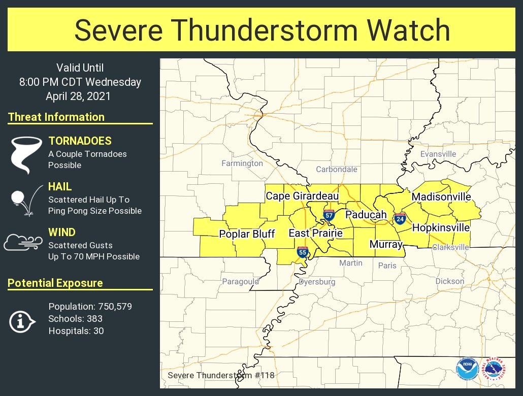
Severe Thunderstorm Watch for Bollinger, Butler, Cape Girardeau, Carter, Mississippi, New Madrid, Ripley, Scott, Stoddard, Wayne [MO] and Ballard, Caldwell, Calloway, Carlisle, Christian, Crittenden, Fulton, Graves, Hickman, Hopkins, Livingston, Lyon, Marshall, McCracken, McLean, Muhlenberg, Todd, Trigg, Webster [KY] and Alexander, Hardin, Johnson, Massac, Pope, Pulaski, Union [IL] till 8:00 PM CDT
.
12:40 PM
SEVERE THUNDERSTORM WARNING
NATIONAL WEATHER SERVICE PADUCAH KY
1235 PM CDT WED APR 28 2021

THE NATIONAL WEATHER SERVICE IN PADUCAH HAS ISSUED A

* SEVERE THUNDERSTORM WARNING FOR...
  CARTER COUNTY IN SOUTHEASTERN MISSOURI...
  RIPLEY COUNTY IN SOUTHEASTERN MISSOURI...

* UNTIL 115 PM CDT.

* AT 1234 PM CDT, SEVERE THUNDERSTORMS WERE LOCATED ALONG A LINE
  EXTENDING FROM 7 MILES NORTHWEST OF EMINENCE TO 10 MILES SOUTH OF
  WINONA TO 8 MILES EAST OF ALTON TO 10 MILES NORTHWEST OF GATEWOOD
  TO NEAR DALTON, MOVING NORTHEAST AT 50 MPH.
.
12:35 PM
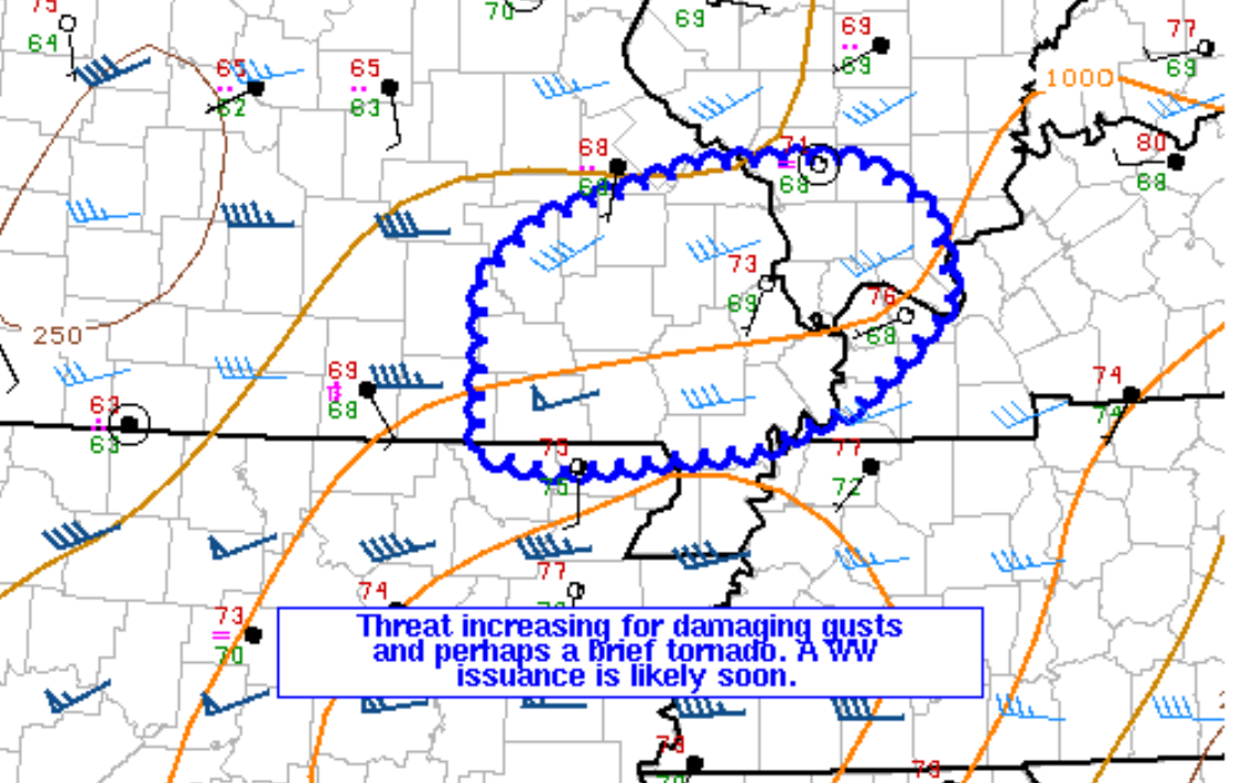
A severe thunderstorm watch is going to be issued.
Mesoscale Discussion 0451
   NWS Storm Prediction Center Norman OK
   1233 PM CDT Wed Apr 28 2021

   Areas affected...portions of southeast Missouri...far southwest
   Illinois...extreme southwest Kentucky

   Concerning...Severe potential...Severe Thunderstorm Watch likely

   Valid 281733Z - 281830Z

   Probability of Watch Issuance...80 percent

   SUMMARY...The severe threat continues across Tornado Watch #0117,
   and some threat for severe may persist downstream of the watch over
   the next couple of hours. A couple of damaging gusts or a brief
   tornado remain the primary threats. A Severe Thunderstorm Watch
   issuance is likely shortly.

   DISCUSSION...A QLCS persists roughly along a Texas/Shannon/Oregon
   County line across southeast Missouri, with MRMS mosaic low-level
   rotation track data showing modest circulations in progress. Ahead
   of the QLCS, surface temperatures in the mid 70s, with near 70F
   dewpoints, support around 1000 J/kg MLCAPE, evident via the latest
   Mesoanalysis. While modest forcing and aforementioned instability
   along a broad confluence/baroclinic zone is expected to support
   downstream propagation of the QLCS, effective SRH has been gradually
   weakening and is expected to continue waning over the next few
   hours. While a brief tornado or two remain possible this afternoon,
   damaging gusts are expected to remain the primary threat. As such, a
   Severe Thunderstorm Watch issuance is likely shortly.

   ..Squitieri/Hart.. 04/28/2021
.
12:15 PM
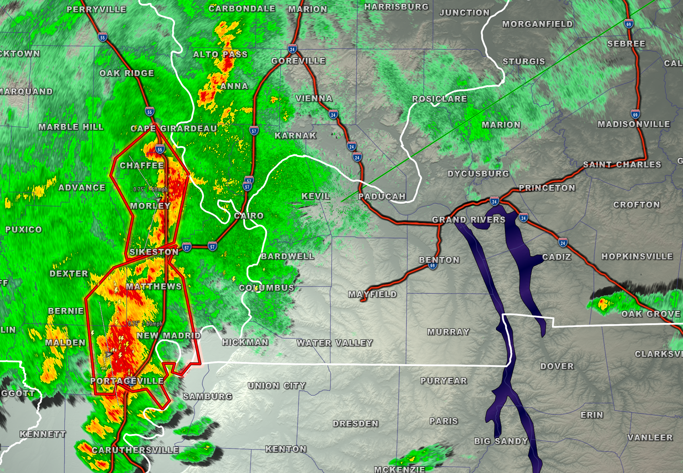
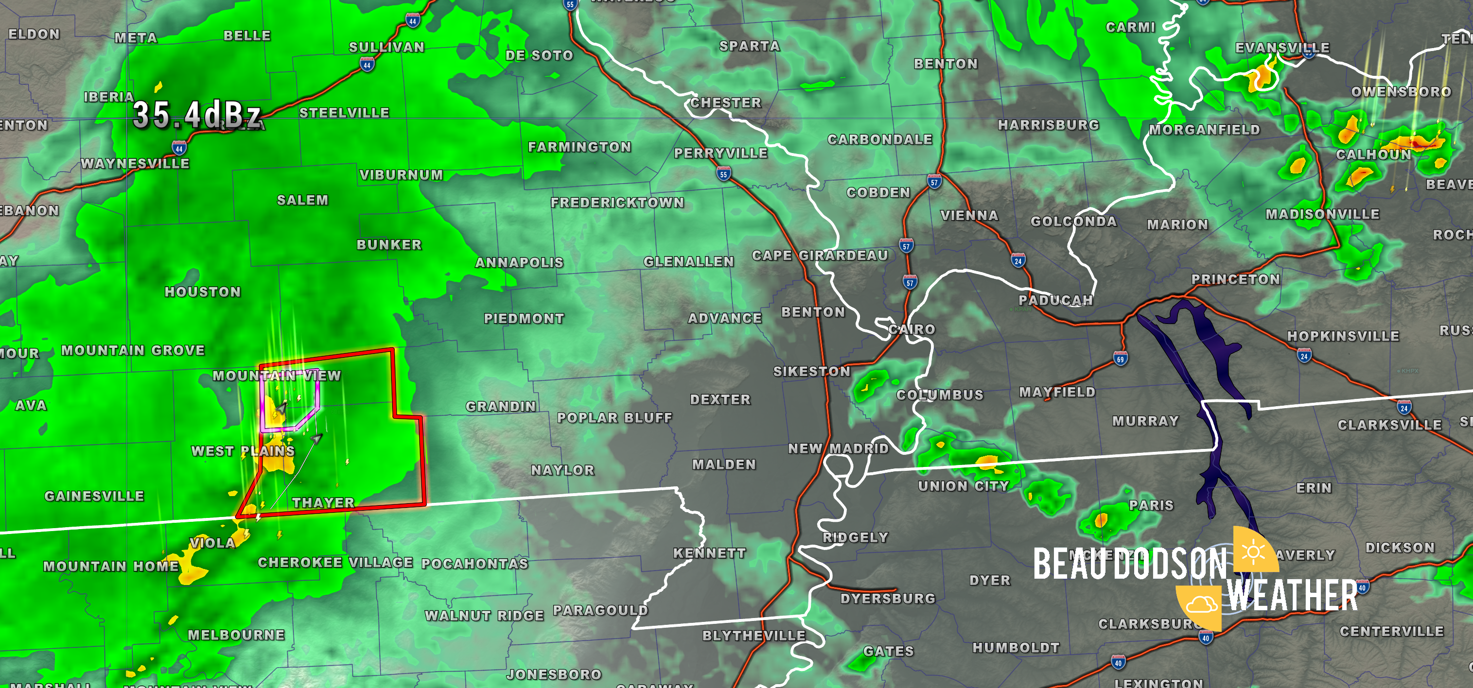
I am watching these storms in southern Missouri. Pink is a tornado warning. Red is a severe thunderstorm warning.
There remain questions about whether they remain severe further east/northeast.
.
10:30 AM
Storm report.
There are reports from southern Missouri of 2.5″ of rain in 30 minutes. Those are incredible rain rates. Rare to see that kind of rain in our region.
.
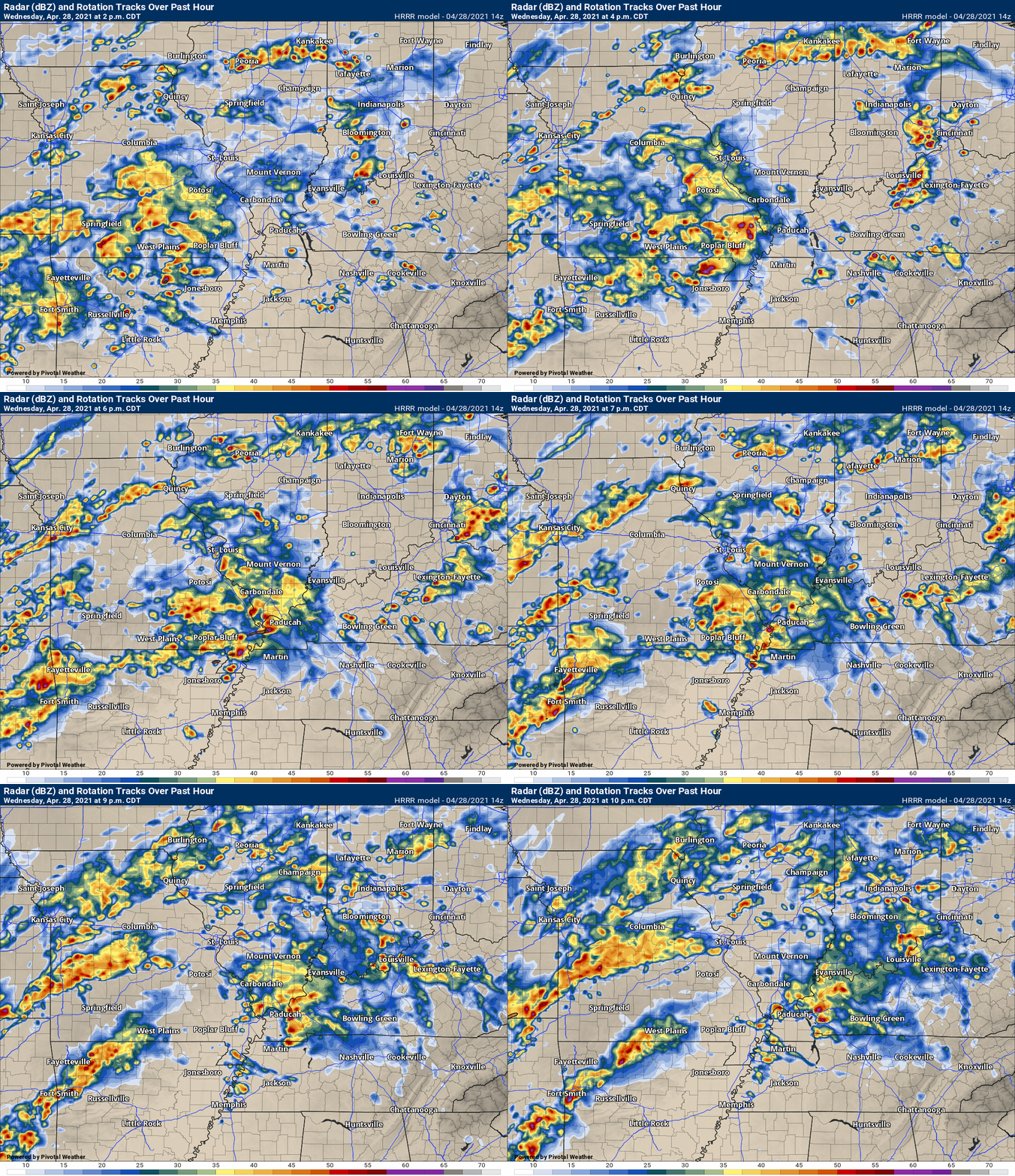
Latest Hrrr model future-cast radar for this afternoon.
.
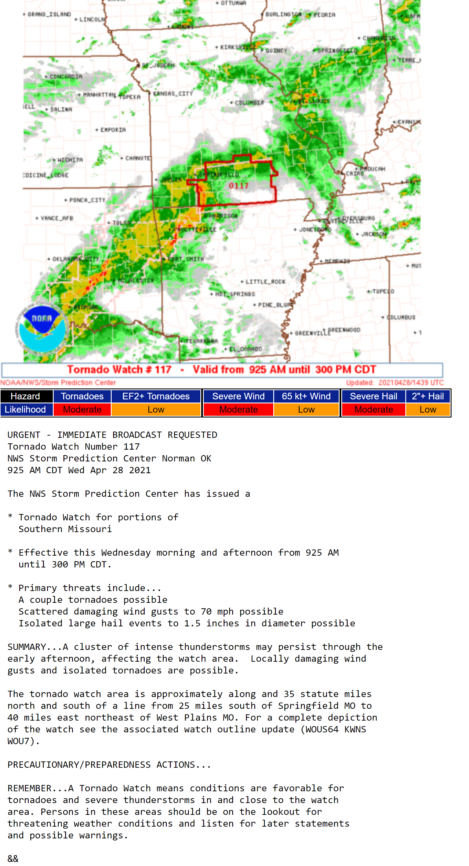
8:45 AM Update
Tornado watch southern MO.
9 AM Update
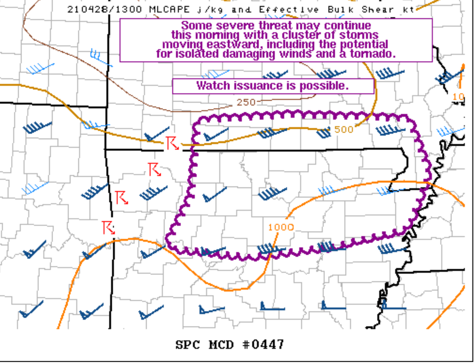
 Mesoscale Discussion 0447
   NWS Storm Prediction Center Norman OK
   0852 AM CDT Wed Apr 28 2021

   Areas affected...Portions of northern AR and southern MO

   Concerning...Severe potential...Watch possible

   Valid 281352Z - 281545Z

   Probability of Watch Issuance...40 percent

   SUMMARY...Some severe threat may continue this morning with a
   cluster of storms moving eastward, including the potential for
   damaging winds and a tornado. Watch issuance is possible.

   DISCUSSION...A loosely organized cluster of storms has developed
   this morning across northwestern AR and southwestern MO. VWPs from
   KLZK/KSRX indicate around 30-35 kt of 0-1 km shear is present, along
   with a favorable veering/strengthening wind profile with height
   through mid levels. Low-level rotation has been noted with a couple
   circulations within the line. An isolated tornado threat may
   continue through the morning across parts of southern MO and
   northern AR where rich low-level moisture, a weakly unstable
   airmass, and strong shear at low levels can support surface-based
   storms. Given the linear nature of the ongoing convection, damaging
   winds may be the primary severe threat. Filtered diurnal heating
   through a cloud deck downstream of this ongoing activity should
   support a gradual increase in boundary-layer instability over the
   next couple of hours. Although convective evolution remains somewhat
   uncertain this morning, downstream watch issuance may be needed if
   storms maintain their current intensity.

   ..Gleason/Hart.. 04/28/2021
.
7 AM update
7 AM Wednesday
I updated all of the graphics.
The SEVERE WEATHER BLOG has been activated for the threat of heavy rain and potentially a couple of severe thunderstorm warnings.
Here is the link for the SEVERE WEATHER BLOG. CLICK HERE.
Flash flood watch. More counties may be added.
Widespread showers and thunderstorms are developing on radar. As of this writing, at 6 AM, there were numerous showers and storms already showing up from Texas into Illinois. This will only increase through today and tonight.
Some of the high resolution models indicate bands of greater than four inches of rain. A flash flood watch was issued for portions of the region. I can’t rule out more counties being added.
Even though recent ground conditions have been mostly dry, rains of this magnitude could cause problems. River flooding is likely in some areas due to the widespread nature of the heavy rain.
There remain some questions about the exact placement of the heaviest rain totals. For now, portions of southeast Missouri and southern Illinois continue to be signaled for a band of three to five inches of rain. Locally higher possible.
As far as far southeast Missouri, the Bootheel, extreme southern Illinois, western Kentucky, and northwest Tennessee…we should remain on alert for the potential of very heavy rain, as well.
Either way, a widespread one to three inch rain event is likely. This could flood some roadways.
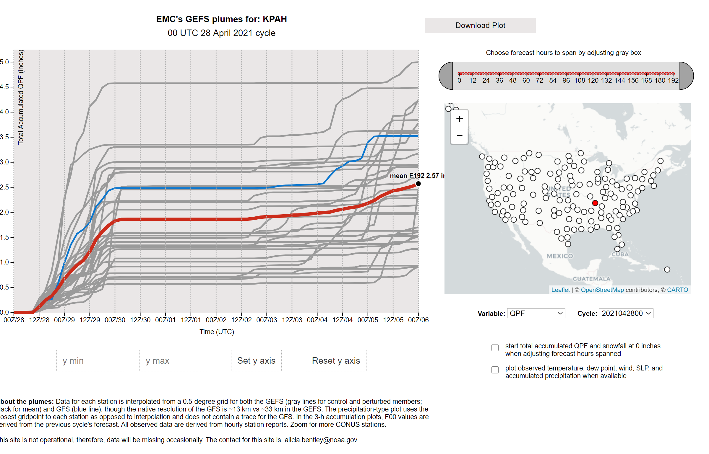
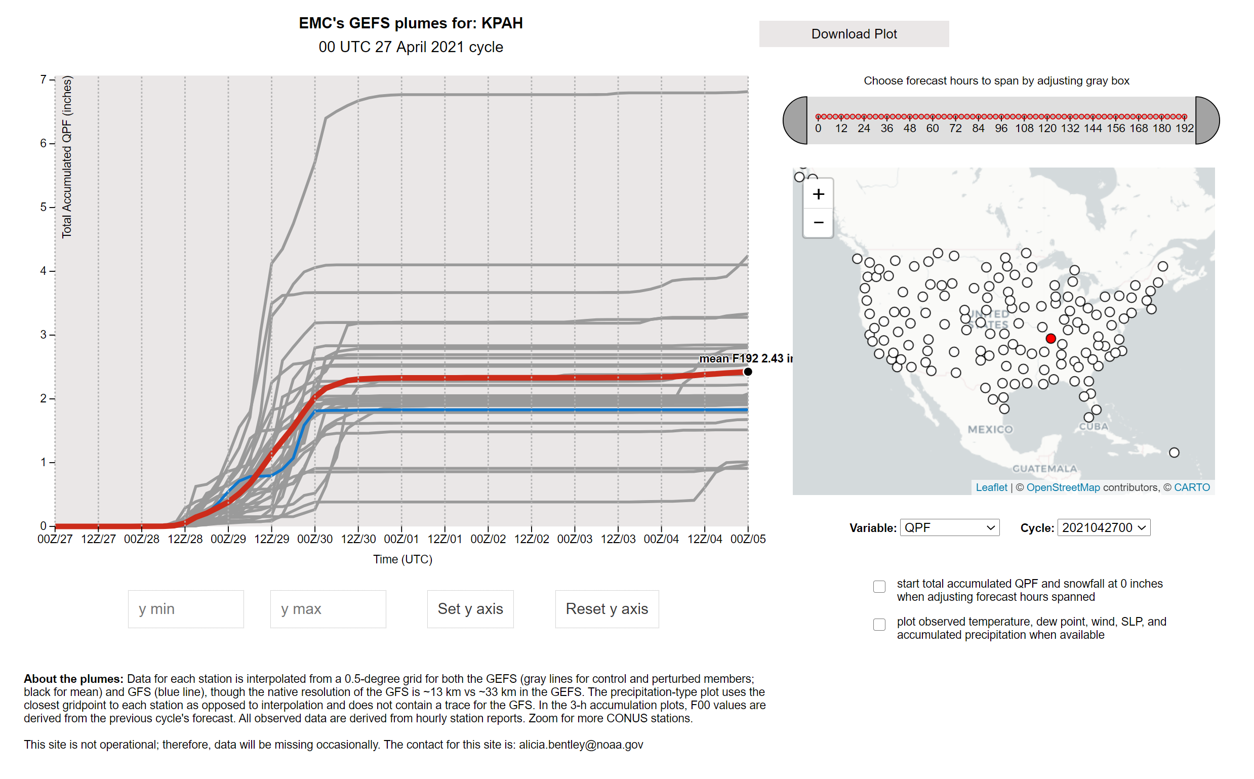
The GFS ensemble plumes are showing a medium reading of 2.57″ for Paducah. This continues to rise with each run of the GFS model. It is a strong signal for locally heavy rain.
.
I continue to monitor the risk of a few severe thunderstorms. The primary concern would be damaging wind gusts, although a brief tornado can’t be ruled out. This is highly dependent on surface instability rising. CAPE is what we call that. Surface CAPE is normally associated with severe thunderstorms.
The Storm Prediction Center has outlined our region in a marginal risk. That would be upgraded to a level two (slight risk) if we had a bit more CAPE to work with. Let’s monitor it.
.
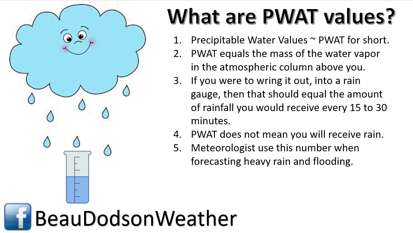
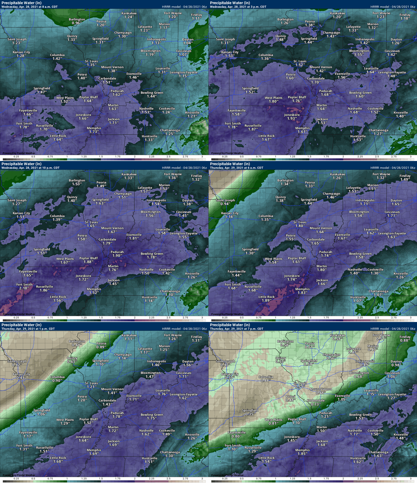
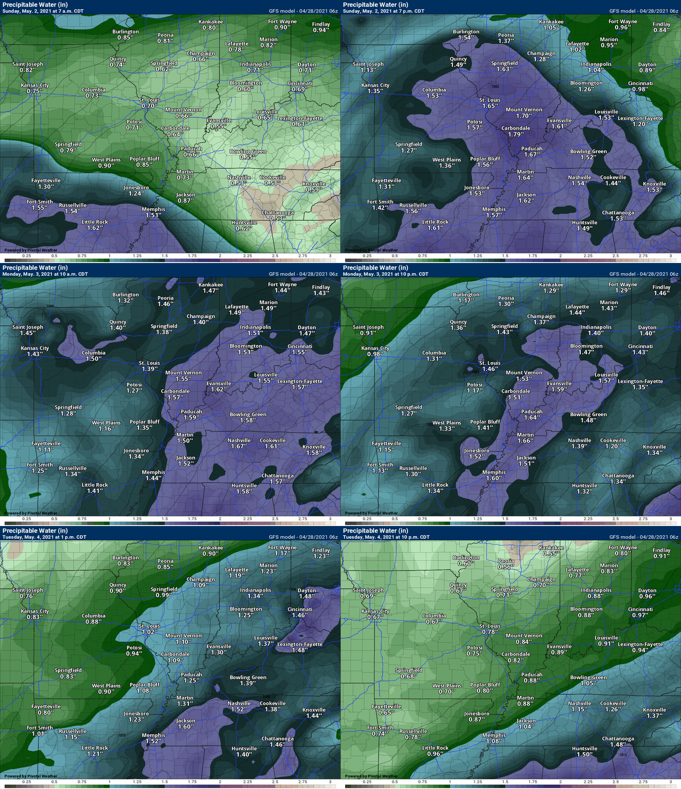
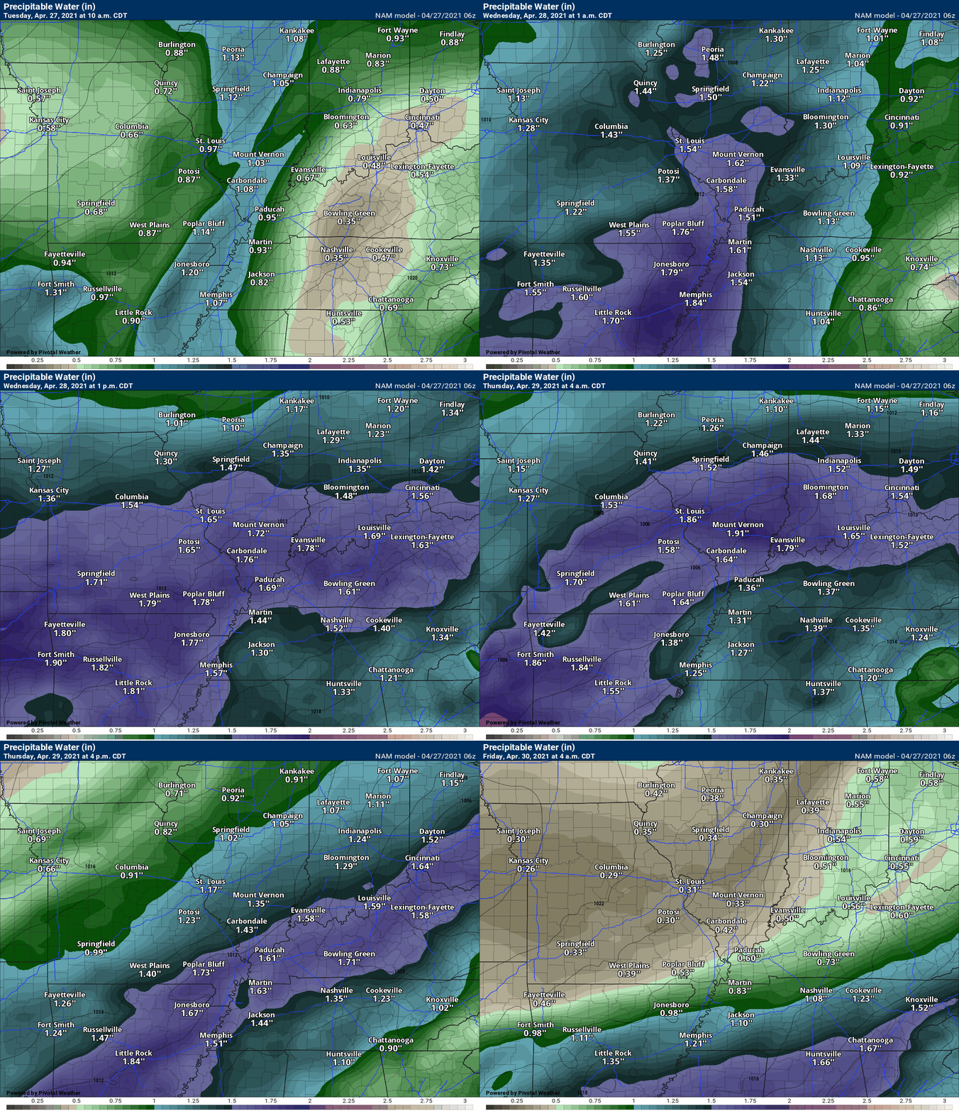
PWAT values will be high for an extended period of time. This is a locally heavy rain signal.
Hrrr model PWAT anomaly animation. A long stretch of moisture with this next system (mid-week). That is an indication that some locally heavy rain may occur.
The dark blue and purple zone are where moisture levels are highest. The longer that lingers over one spot, the greater the chance of heavier rain totals.
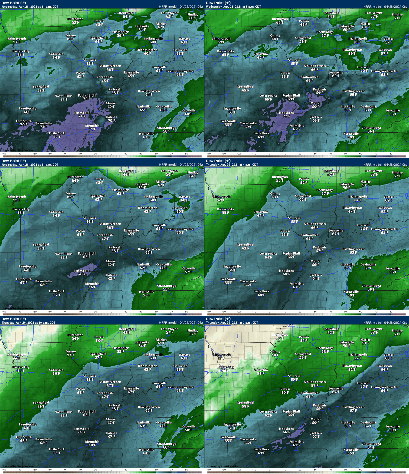
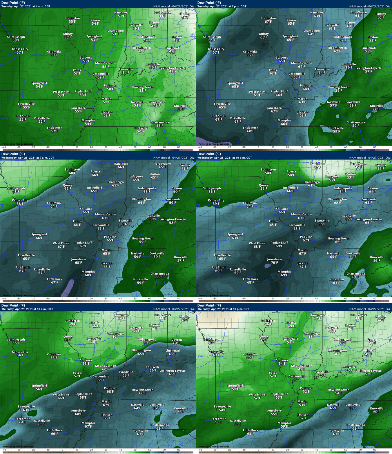
.Dew point is used to determine moisture in the lower levels. A few point around 70 is muggy air.
Check out the Hrrr high resolution model forecast for dew points. This is a copious of amount of moisture for thunderstorms to tap into.
.
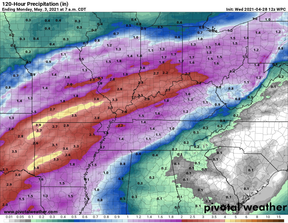
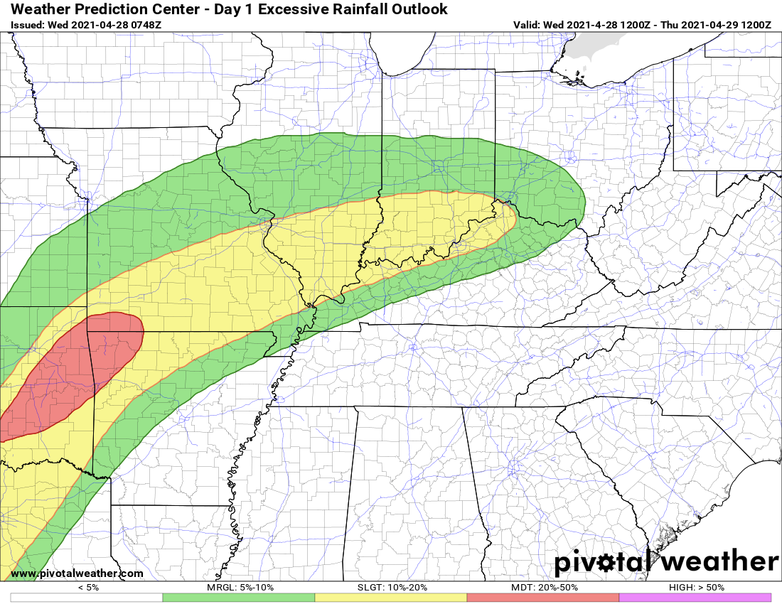
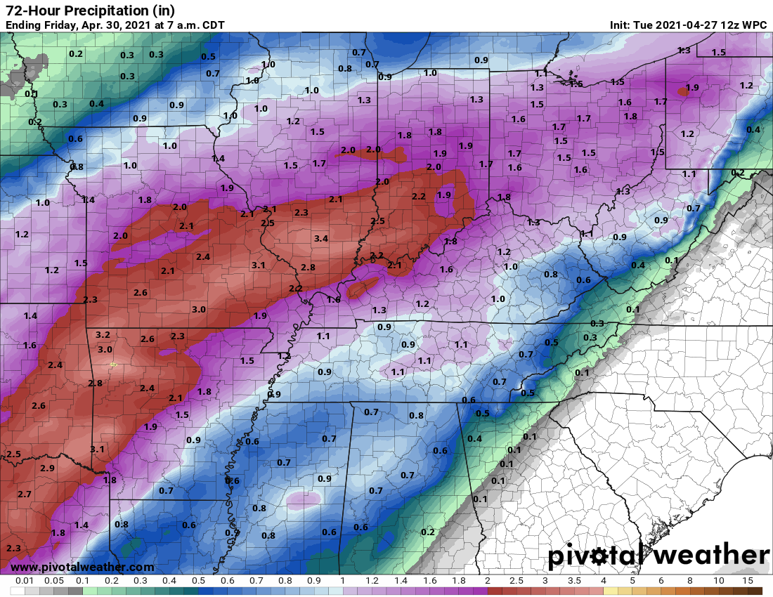
Here is the NOAA rainfall forecast through Thursday.
Click on the images to enlarge them.
.
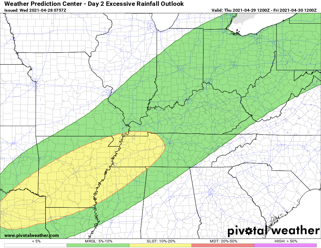
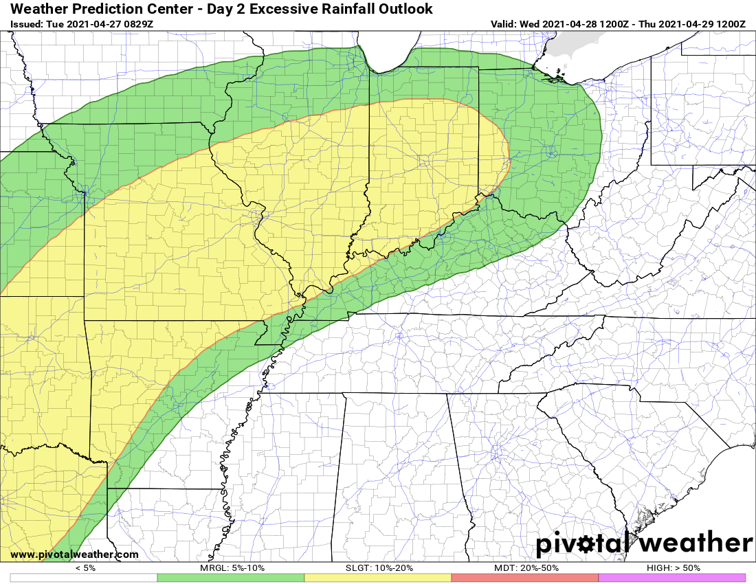
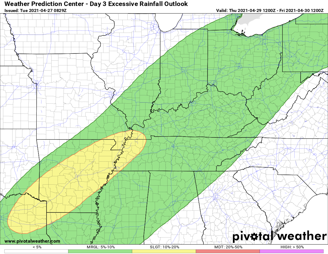
NOAA/WPC does have portions of our region in a martingale to slight risk of excessive rainfall. That simply means there could be enough rain to trigger some water issues. Let’s keep an eye on the placement of the yellow zone.
Today and tonight
.
And the Thursday excessive rainfall outlook. This may need adjusting further northeast with the slight risk zone.
.
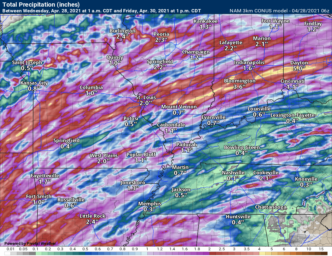
Click on the images to enlarge them.
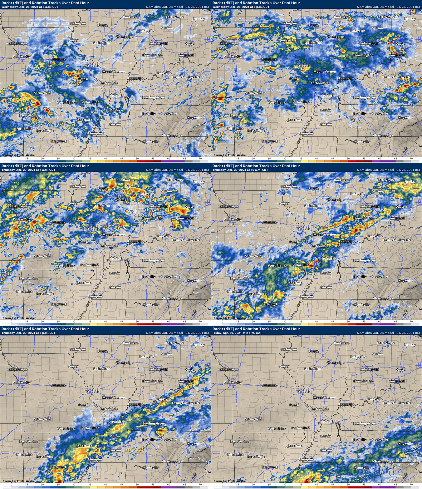
NAM 3K model. Look at the significant differences in the guidance.
.
Hrrr model through Thursday.
The Hrrr has always been further south with the heaviest rain vs the other models. This is something that needs to be watched.
.
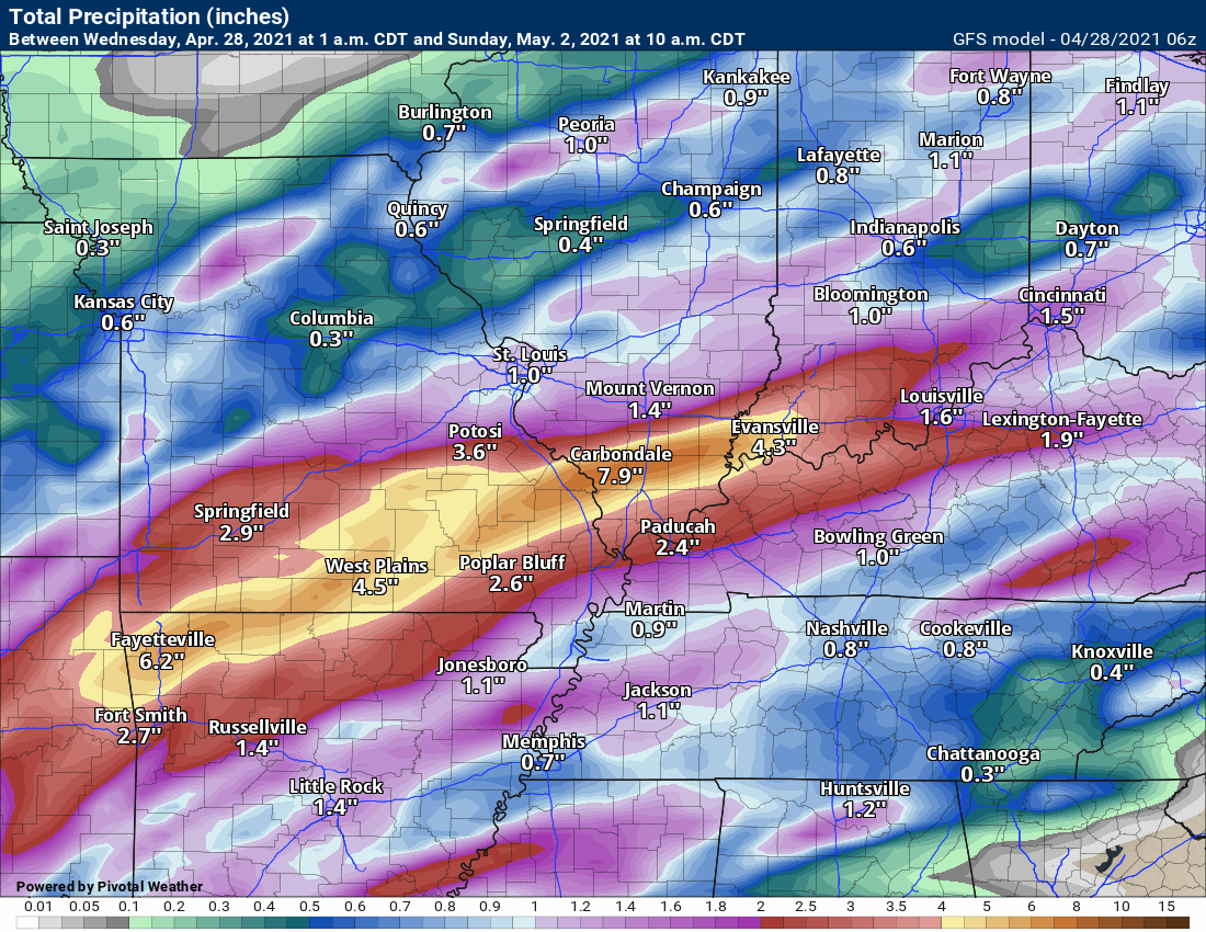
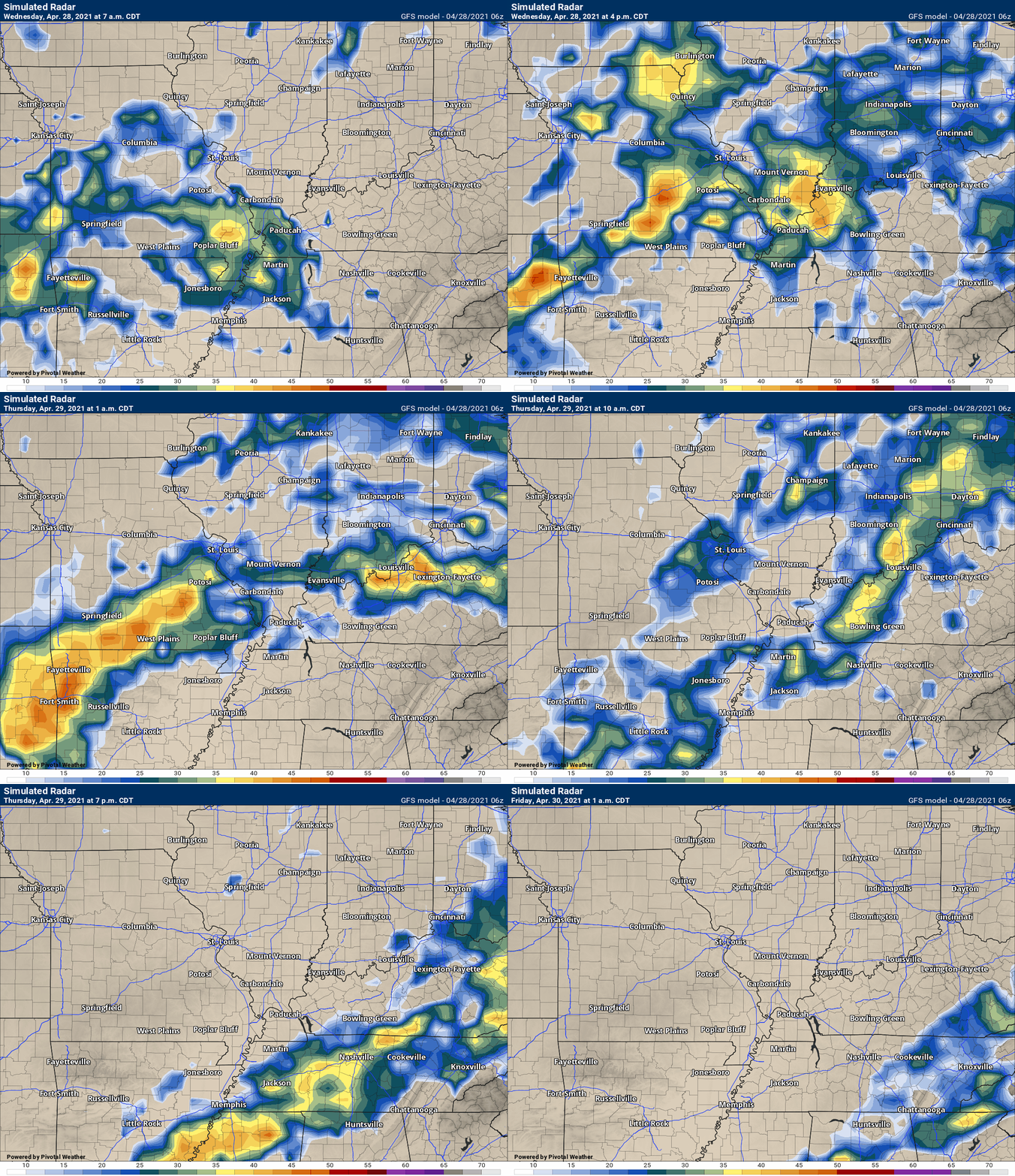
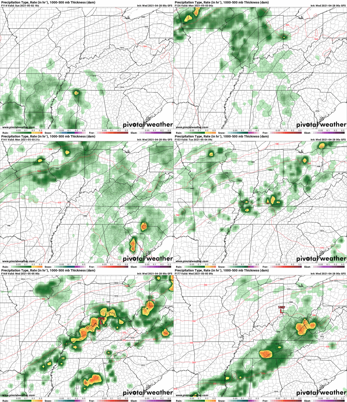
GFS model continues to slowly edge southward.
.
We dry out Thursday afternoon and night. Dry Friday through Saturday night. I had to increase shower/thunderstorm chances Sunday night into next week.
Some of the data shows rain Sunday afternoon. Let’s keep an eye on it. Either way, it appears rain chances will return at some point Sunday into next week. I can’t rule out locally heavy rain.
Of some concern, PWAT’s next week. They return to very high numbers. This could mean more heavy rain. Not what we want to hear.
.
Needless to say, the risk of river flooding over the next few weeks will be higher than normal. Especially true if we have heavy rain next week (on top of this event).
Additional flash flooding is also likely if next weeks event pans out, as well.
.

Click here if you would like to return to the top of the page.
Again, as a reminder, these are models. They are never 100% accurate. Take the general idea from them.
What should I take from these?
- The general idea and not specifics. Models usually do well with the generalities.
- The time-stamp is located in the upper left corner.
- The EC European weather model is in Zulu time.
.
What am I looking at?
You are looking at different models. Meteorologists use many different models to forecast the weather. All models are wrong. Some are more wrong than others. Meteorologists have to make a forecast based on the guidance/models.
I show you these so you can see what the different models are showing as far as precipitation. If most of the models agree, then the confidence in the final weather forecast increases.
You can see my final forecast at the top of the page.
.
This animation is the Storm Prediction Center WRF model.
This animation shows you what radar might look like as the next system pulls through the region. It is a future-cast radar.
Time-stamp upper left. Click the animation to enlarge it.
.
This animation is the Hrrr short-range model.
.
.This animation is the 3K NAM American Model.
This animation shows you what radar might look like as the next system pulls through the region. It is a future-cast radar.
Time-stamp upper left. Click the animation to enlarge it.
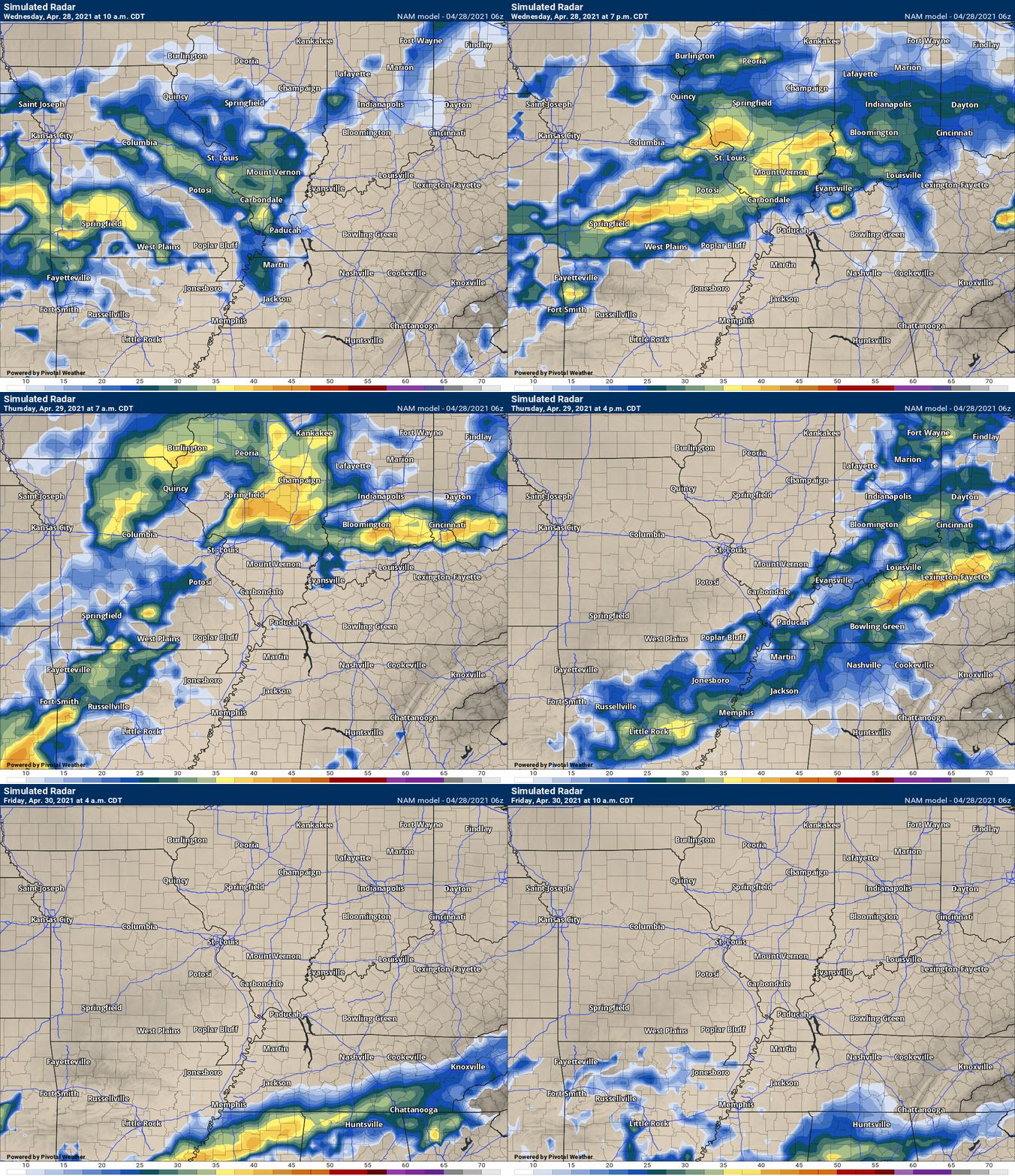
This next animation is the lower-resolution NAM American Model.
This animation shows you what radar might look like as the system pulls through the region. It is a future-cast radar.
Time-stamp upper left. Click the animation to enlarge it.
.
This next animation is the GFS American Model.
This animation shows you what radar might look like as the system pulls through the region. It is a future-cast radar.
Time-stamp upper left. Click the animation to enlarge it.
With more rain possible next week.
.
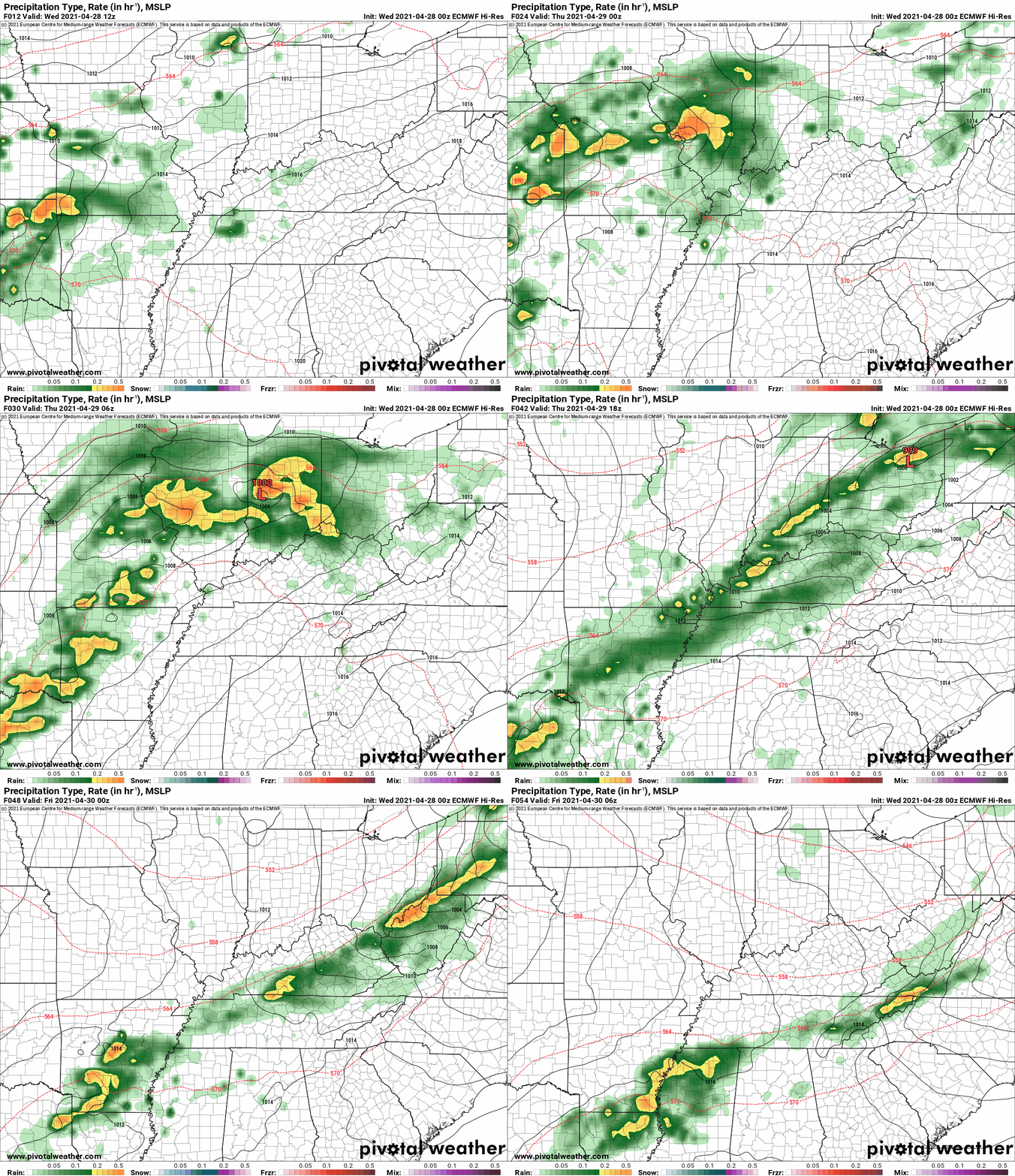
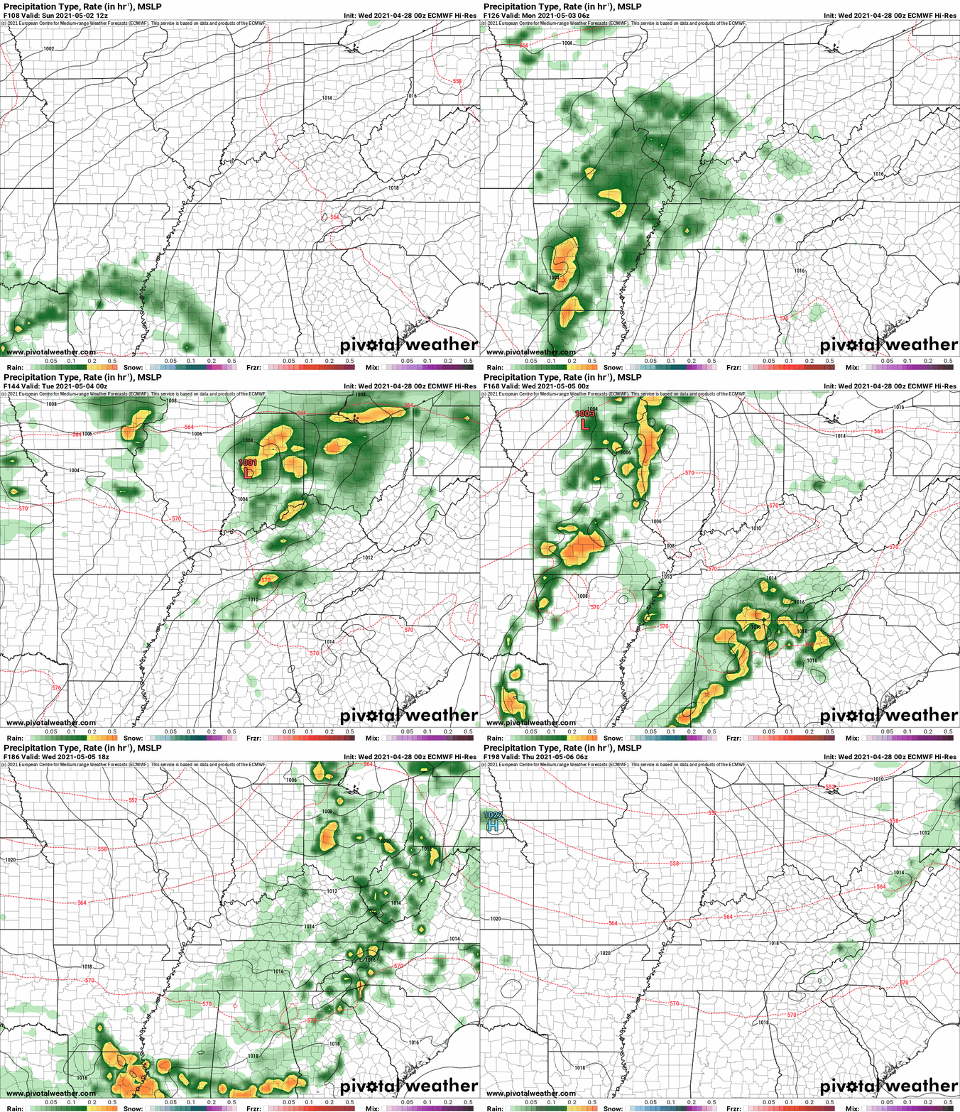
This next animation is the EC European Weather model.
This animation shows you what radar might look like as the system pulls through the region. It is a future-cast radar.
Time-stamp upper left. Click the animation to enlarge it.
With more rain possible next week.
.
3 PM Update
FROM WEDNESDAY AFTERNOON THROUGH THURSDAY EVENING

* THERE WILL BE THE POTENTIAL FOR SEVERAL ROUNDS OF MODERATE TO HEAVY
  RAINFALL. FROM 2 TO 4 INCHES OF RAINFALL WILL BE POSSIBLE. LOCALLY
  HIGHER AMOUNTS CANNOT BE RULE OUT. THIS WATCH IS GENERALLY IN AFFECT
  FOR LOCATIONS NORTH OF A LINE EXTENDING FROM DONIPHAN, MISSOURI TO
  PADUCAH, KENTUCKY TO CALHOUN, KENTUCKY.


* IN ADDITION TO THE FLASH FLOOD POTENTIAL OF URBAN AND RURAL AREAS,
  MAIN STEM RIVERS MAY ALSO BE AFFECTED OUT IN TIME.
1PM update.
Here are the Storm Prediction Center comments concerning tomorrow’s severe weather risk.
Southeast MO/Lower OH Valley...

   Forecast guidance continues to be uncertain regarding severe
   potential across this area. Morning convection will likely have some
   influence over how much destabilization occurs across parts of
   southern MO. Furthermore, poor midlevel lapse rates will hinder
   greater instability and storm organization. Nevertheless, 30-40 kt
   midlevel southwesterly flow will exist over the region, with at
   least some backed southerly winds ahead of the front and weak
   instability. Some guidance suggests some forward-propagating
   clusters could develop and result in some locally strong wind gust
   potential. However, deep layer flow mostly parallel to the cold
   front also could result in storms becoming undercut by outflows or
   the front itself. Nevertheless, a narrow corridor of conditional
   severe potential may exist from parts of southeast MO/far northwest
   AR into western KY where strong gusts and perhaps a tornado could
   occur.
End
12 PM update. Tuesday, April 27. 2021.
The morning data is in. There was a slight shift southward in the heavy rain band. This will need to monitor. Please continue reading further down in the blog for extensive details.
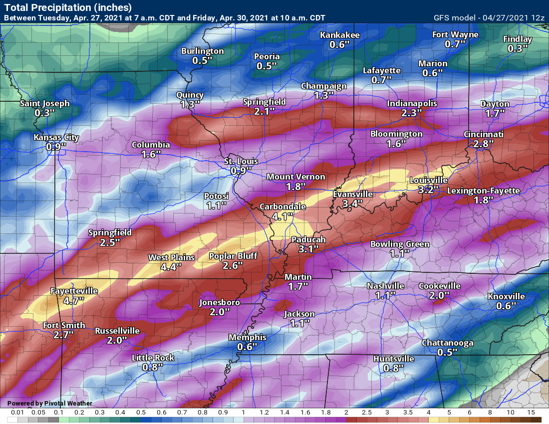
Here is what the GFES showed. Ensembles.
Here is the operational GFS. Notice it shifted south a tad. See earlier model runs further down in this blog update.
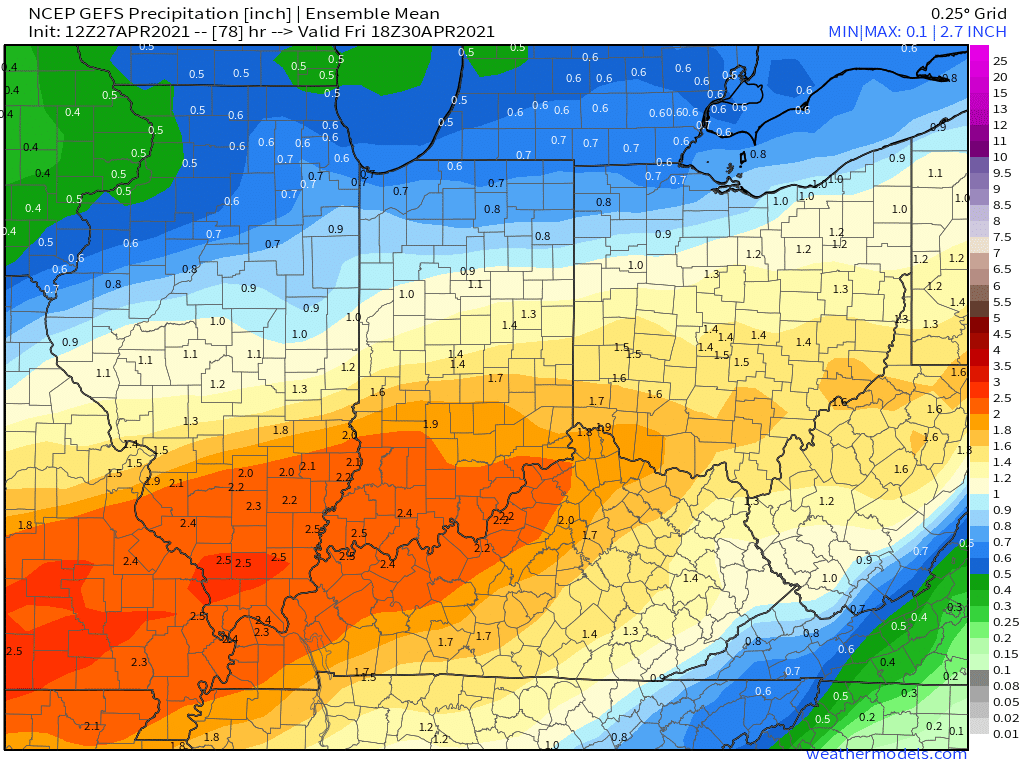
Here is the GEFS ensemble mean. All the GFS ensembles members combined.
.
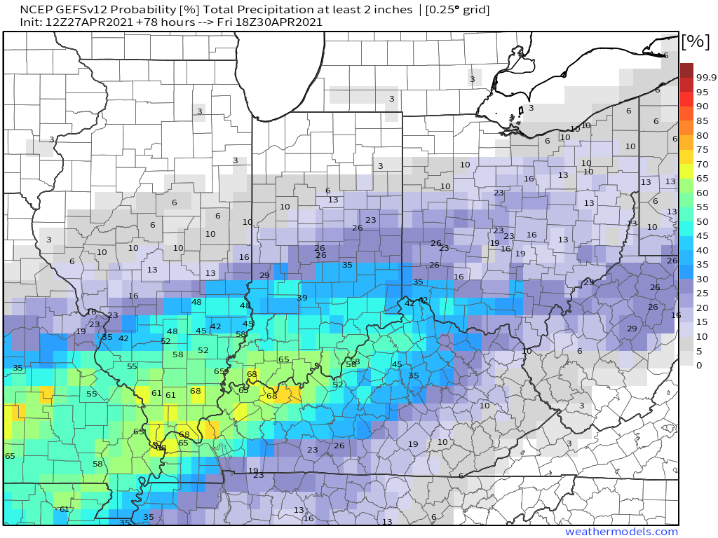
What is the chance of two or more inches of rain? GEFS model ensembles.
.
Very difficult forecast when it comes to how much rain is going to fall. Lot to monitor over the next 24 to 48 hours.
.
.
Today through May 3rd. Some thunderstorms could be severe with damaging wind being the primary concern. There could be an area of higher risk over portions of southern Illinois, Kentucky, far southeast Missouri, and northwest Tennessee. There is higher than normal uncertainty about the placement of the greater risk zone.
The Storm Prediction Center is closely monitoring the situation for both Wednesday and Thursday. There may have to be a higher risk zone introduced. That would likely be a slight risk (level 2 of 5). Let’s keep an eye on it.
Locally heavy rain is likely with this event. Some locations could top three inches of rain. Some of the data shows greater than four inches.
Another thunderstorm episode is possible next Tuesday or Wednesday. Several days to monitor that event.
.
.
Today’s outlook (below).
Light green is where thunderstorms may occur but should be below severe levels.
Dark green is a level one risk. Yellow is a level two risk. Orange is a level three (enhanced) risk. Red is a level four (moderate) risk. Pink is a level five (high) risk.
One is the lowest risk. Five is the highest risk.
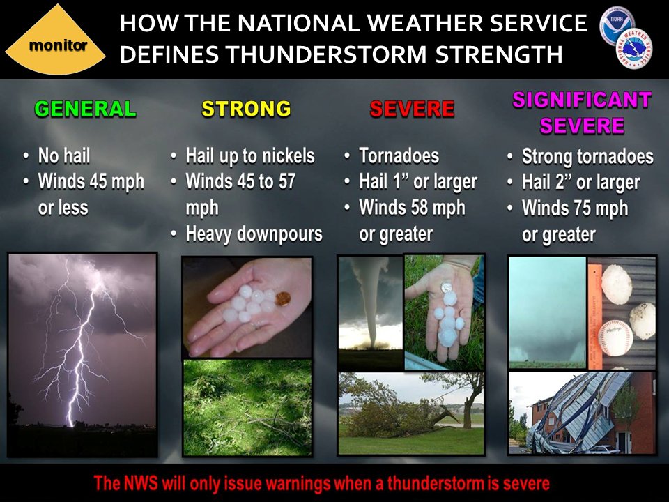
A severe storm is one that produces 58 mph wind or higher, quarter size hail, and/or a tornado.
The tan states are simply a region that SPC outlined on this particular map. Just ignore that.

The black outline is our local area.

.
Tomorrow’s severe weather outlook.

.

.
The images below are from the WPC. Their totals are a bit lower than our current forecast. I wanted to show you the comparison.
24-hour precipitation outlook.
.
 .
.
48-hour precipitation outlook.
.
.
72-hour precipitation outlook.
.
.
![]()
![]()

![]()
.Weather advice:
Locally heavy rain Wednesday into Thursday. Some roadways could flood. Training showers and thunderstorms will be the culprit. Training is when thunderstorms repeatedly move over the same areas.
Some thunderstorms could produce high winds.
.
Weather Discussion
-
- Warm today! Windy.
- Rain chances will ramp up tonight into Thursday.
- Locally heavy downpours but the severe risk appears small.
.
6 AM Tuesday.
I updated all of the graphics.
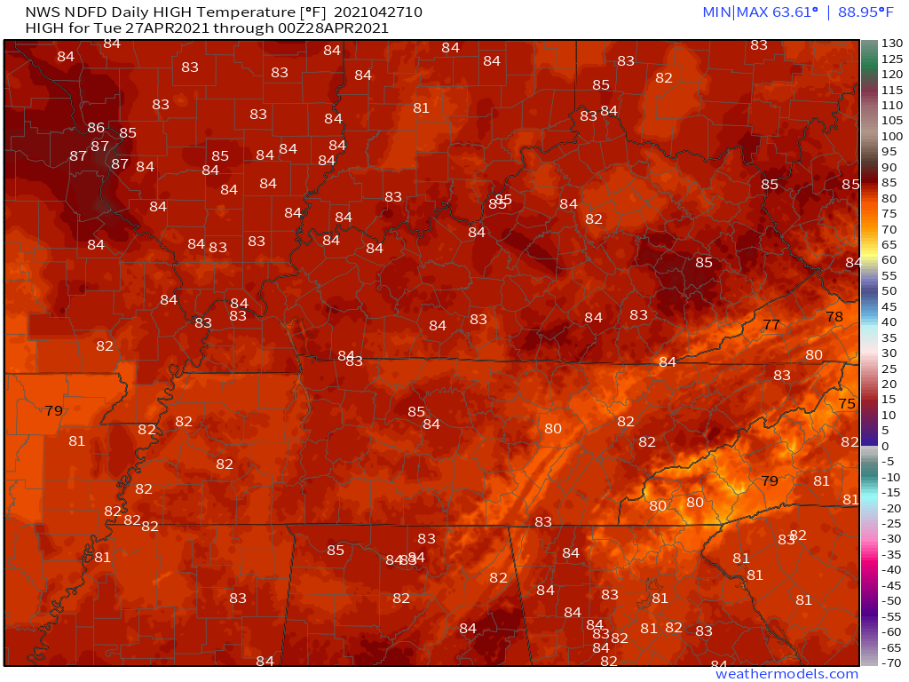
It will be quite warm today. St Louis, Missouri, area could reach the middle 80s. I would not be surprised if there are some upper 80s in that area.
Our region will solidly be in the 80s, as well.
Tuesday
.
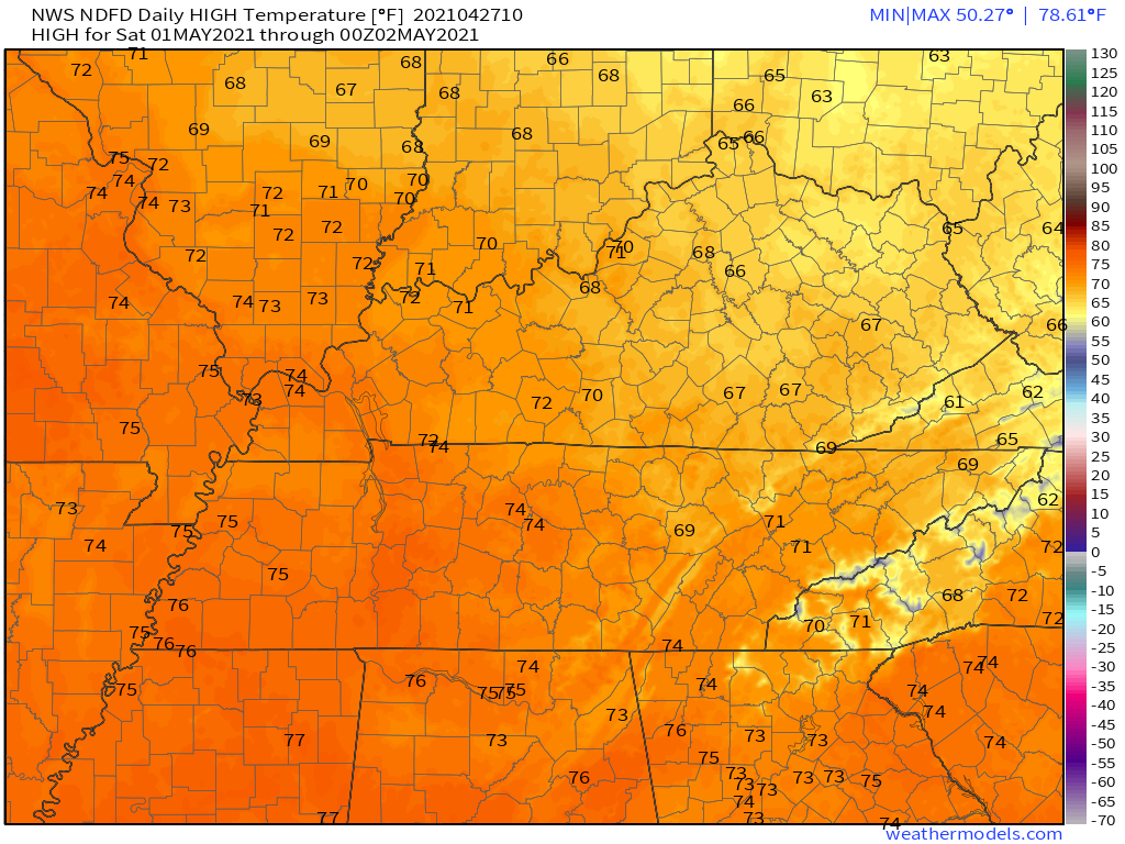
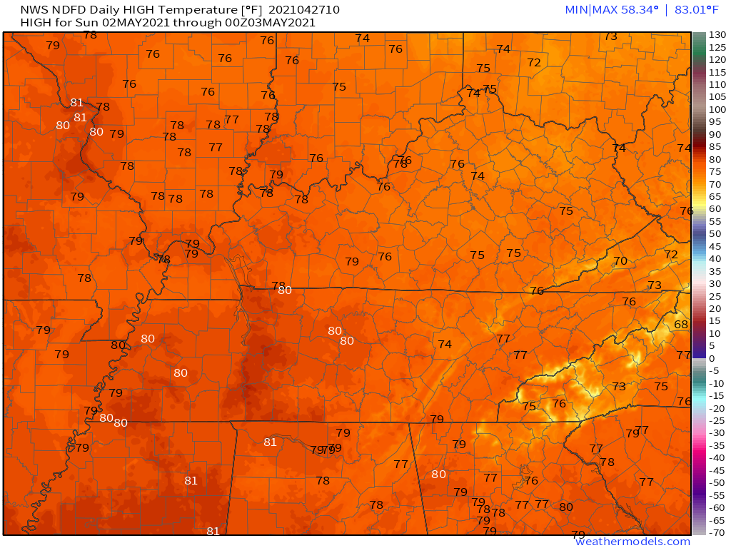
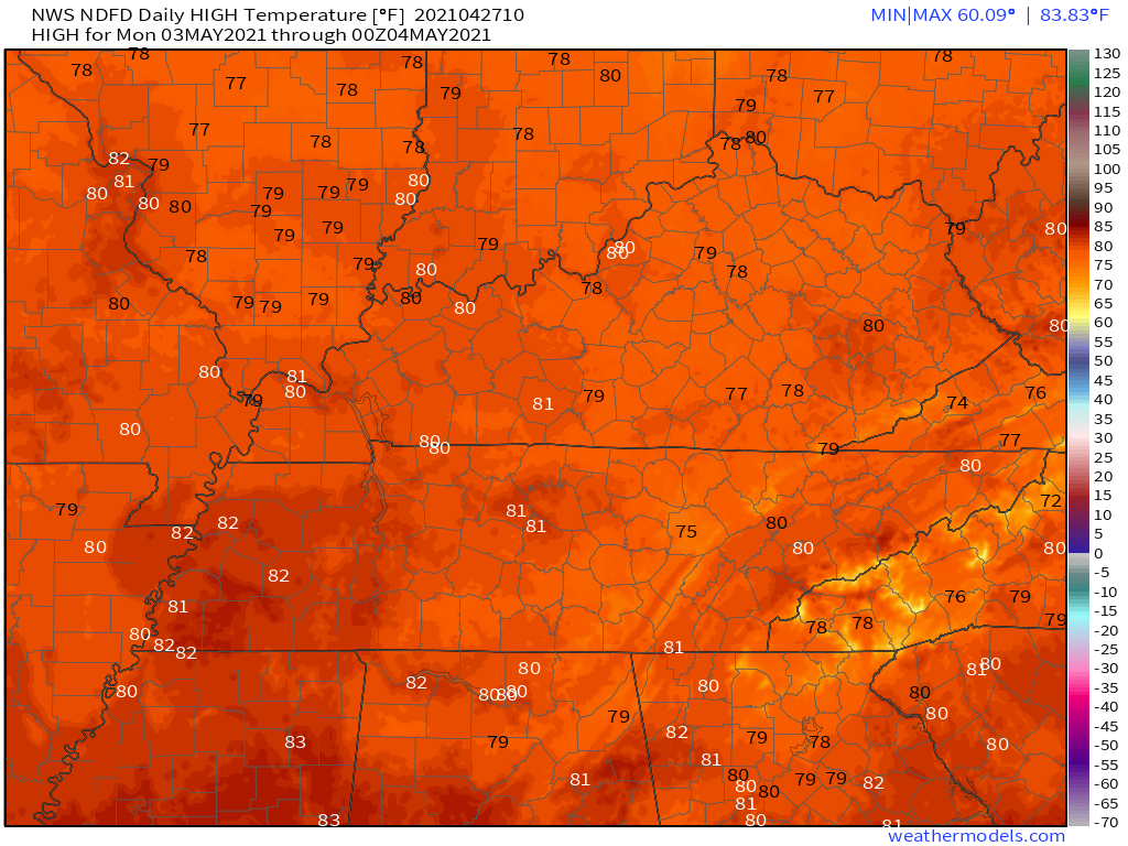
Rain Wednesday and Thursday will keep temperatures a bit lower (at least over MO/IL).
Check out Saturday and Sunday’s temperatures. I did increase them a bit.
Saturday
.
Sunday
.
Monday
.
Enjoy today’s warm temperatures.
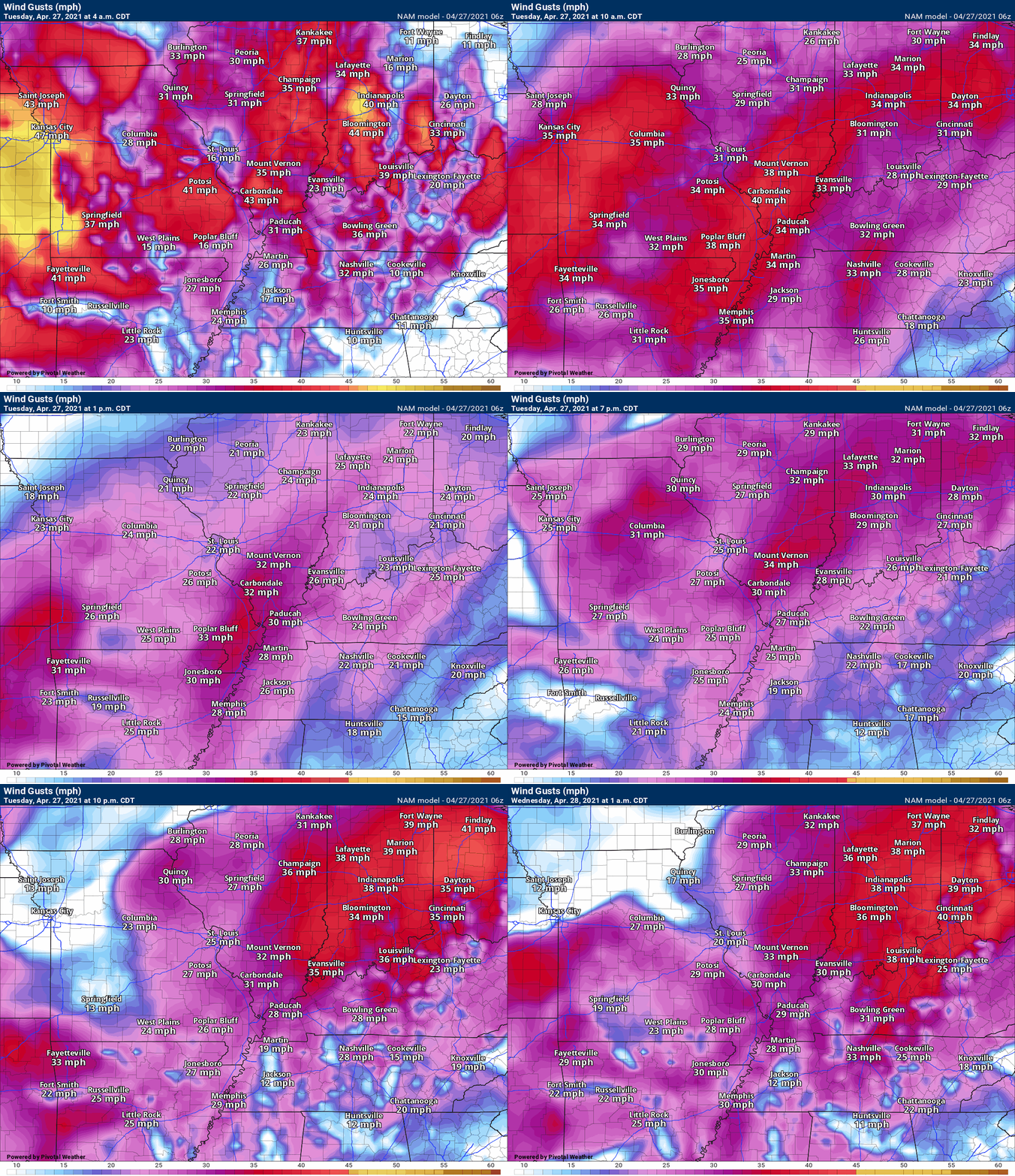
There will be gusty winds over the region today. As a matter of fact, winds may gust above 35 mph Tuesday.
I would not be surprised to see some gradient winds top 40 mph. Gradient winds are from the barometric pressure difference over the region.
.
Widespread showers and thunderstorms will develop late Tuesday night into Wednesday morning. Some of these thunderstorms could be prolific rain producers. As a matter of fact, there has been an uptrend in guidance over the past 24 hours.
Some of the high resolution models indicate bands of greater than four inches of rain. This will need to be monitored for the possibility of flood or flash flood warnings.
Even though recent ground conditions have been mostly dry, rains of this magnitude could cause problems. River flooding is likely in some areas due to the widespread nature of the heavy rain.
There is a higher than normal uncertainty surrounding the evolution of the two areas of concern. The northern and western half of southeast Missouri and southwest and northern southern Illinois and then that second potential max zone from the Missouri Bootheel into western Kentucky.
Perhaps the greater uncertainty centers around the Bootheel into Kentucky potential. Perhaps extreme southern Illinois.
The bottom line is that there is a lot of moisture for this event to work with. A deep warm layer will also aid in the development of heavy rain.
Monitor updates if you have water concerns.
Area-wide, I am forecasting a 1.00″ to 3.00″ rain event. With pockets of three or more inches likely over southeast Missouri and southern Illinois.
The GFS ensemble plumes are showing a medium reading of 2.45″ for Paducah.
This is a decent increase from yesterday’s update.
.
The severe weather risk has increased just a tad. Model guidance indicates the potential of a few thunderstorms producing pockets of wind damage. Although the severe weather risk is not great, it is enough to warrant our attention. Monitor updates both Wednesday and Thursday. A few storms could become severe.
PWAT values will be high for an extended period of time. This is a locally heavy rain signal.
GFS PWAT anomaly animation. A long stretch of moisture with this next system (mid-week). That is an indication that some locally heavy rain may occur.
The dark blue and purple zone are where moisture levels are highest. The longer that lingers over one spot, the greater the chance of heavier rain totals.
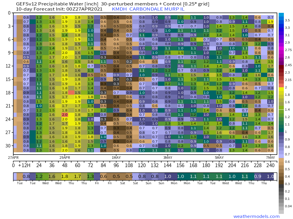
This chart shows you PWAT values for Carbondale, Illinois. The days are at the bottom. The PWAT values are on the right axis.
The left side is the number of ensembles. Ensembles are a model that they run over and over again to see if each run agrees with the next one.
The more that agree, the higher the confidence in the forecast. These are very high numbers for late April. Two standard deviations high. What does that mean? It means there is a lot of moisture in the atmosphere for thunderstorms to work with.
Click to enlarge.
.
Dew point is used to determine moisture in the lower levels. A few point around 70 is muggy air.
Check out the NAM forecast for dew points. This is a copious of amount of moisture for thunderstorms to tap into.
.
Here is the NOAA rainfall forecast through Thursday.
Click on the images to enlarge them.
.
NOAA/WPC does have portions of our region in a martingale to slight risk of excessive rainfall. That simply means there could be enough rain to trigger some water issues. Let’s keep an eye on the placement of the yellow zone.
.
And Wednesday excessive rainfall outlook. This may need adjusting further northeast with the slight risk zone.
.
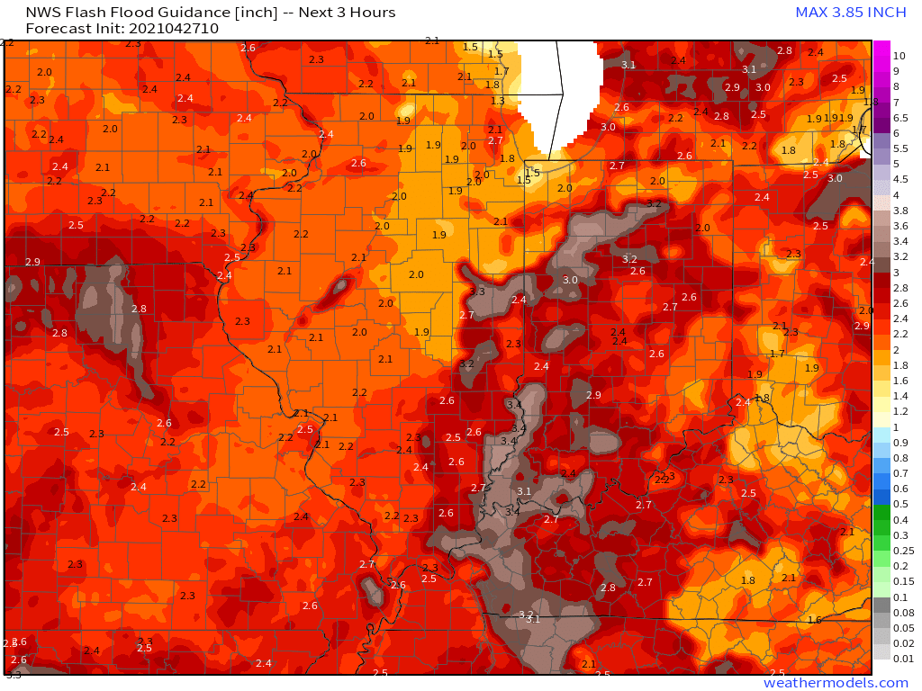
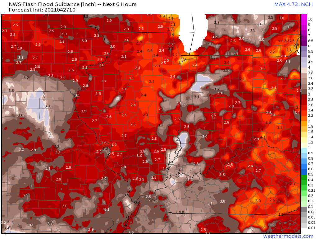
Flash Flood Guidance
Three hour rain totals to trigger flash flooding
Click on the images to enlarge them.
Six hour rain totals to trigger flash flooding
.
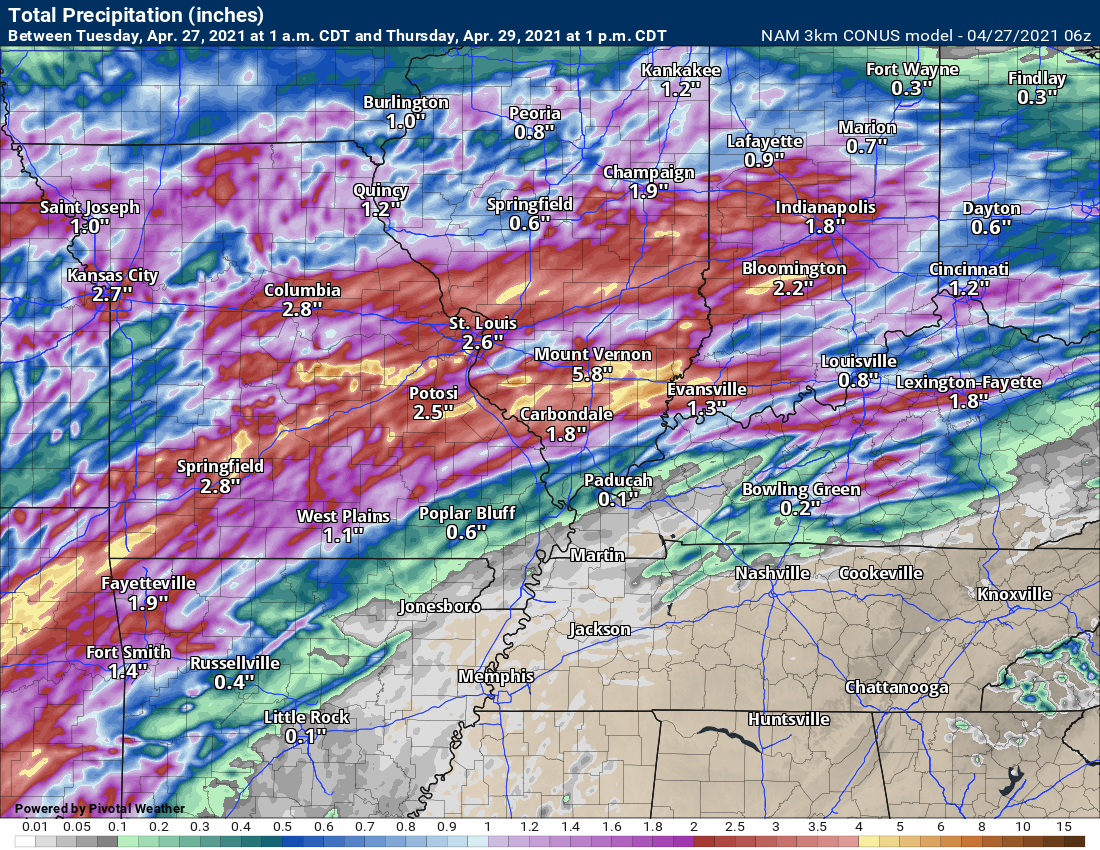
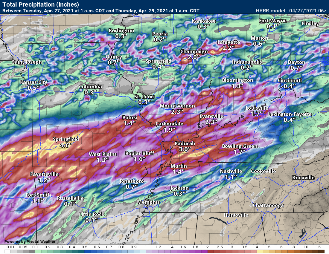
You can see there are difference in the guidance. Check out the NAM 3K. Very little rain on the southern end of this system. This raises concerns about eventual rain totals.
Confidence in heavy rain across parts of southeast Missouri and southern Illinois remain high.
Confidence from the Bootheel of Missouri into extreme southern Illinois, western Kentucky, and northwest Tennessee remain low.
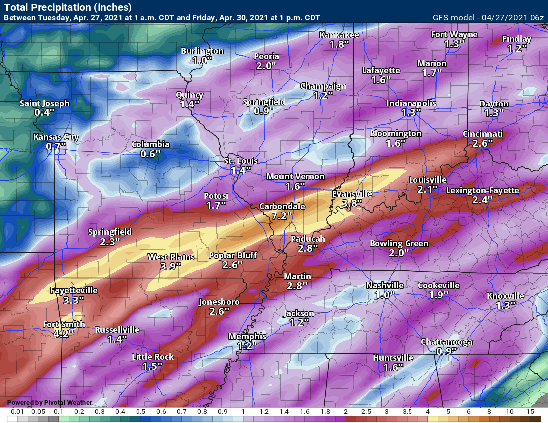
NAM model rainfall forecast
Click on the images to enlarge them.
.
NAM 3K model. Look at the significant differences in the guidance.
.
Hrrr model through 1 AM Thursday. More rain follows after this time-period.
.
GFS model
.
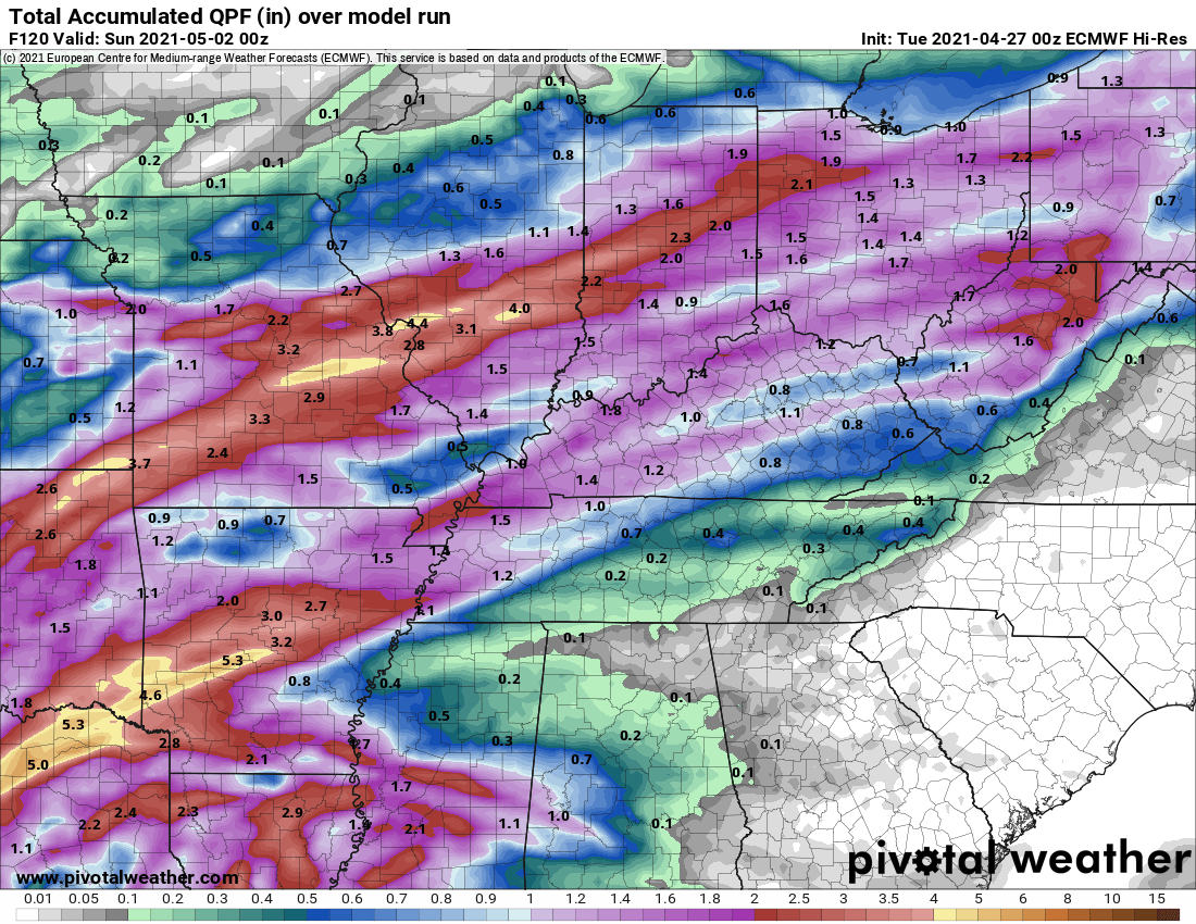
EC model
.
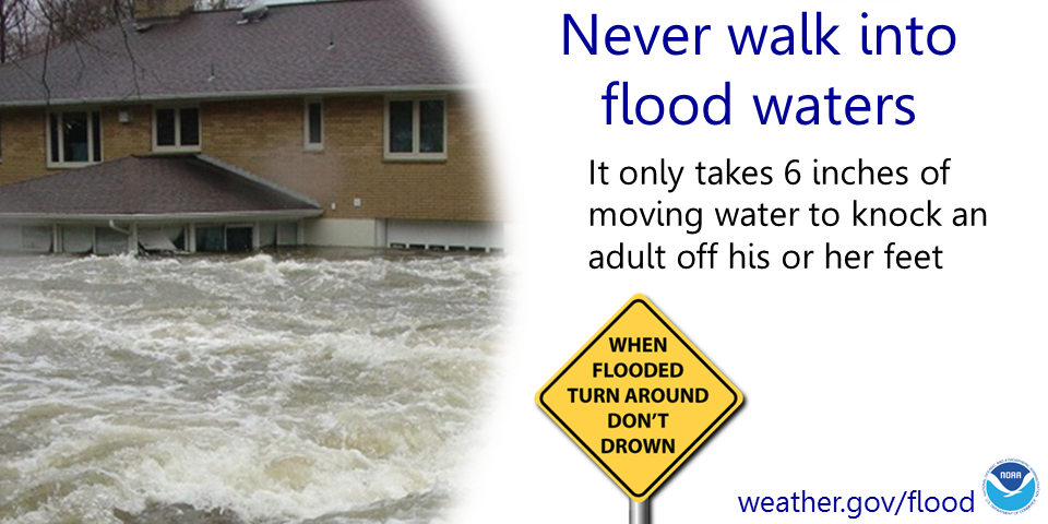
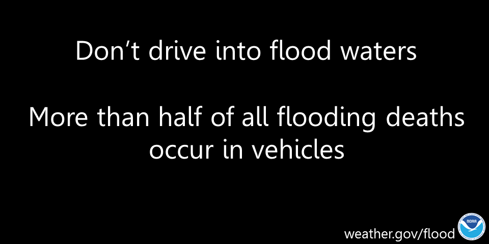
Some safety graphics.
.
.
.
.
.
.![]()
.

Again, as a reminder, these are models. They are never 100% accurate. Take the general idea from them.
What should I take from these?
- The general idea and not specifics. Models usually do well with the generalities.
- The time-stamp is located in the upper left corner.
- The EC European weather model is in Zulu time.
.
What am I looking at?
You are looking at different models. Meteorologists use many different models to forecast the weather. All models are wrong. Some are more wrong than others. Meteorologists have to make a forecast based on the guidance/models.
I show you these so you can see what the different models are showing as far as precipitation. If most of the models agree, then the confidence in the final weather forecast increases.
You can see my final forecast at the top of the page.
.
This animation is the Storm Prediction Center WRF model.
This animation shows you what radar might look like as the next system pulls through the region. It is a future-cast radar.
Time-stamp upper left. Click the animation to enlarge it.
OLD ANIMATIONS ARE DELETED TO SPEED UP THE PAGE
.
What you need to know.
Key Points
- Thunderstorm activity will increase late Tuesday night through Thursday.
- The primary concern will heavy rain. Potentially very heavy rain in some areas. Guidance indicates a couple of bands of rain in the 3 to 5 inch rain. This would most likely occur across southeast Missouri and southern Illinois, but other areas should monitor for adjustments in the placement of the heaviest bands.
- Heavy rain could cause flash flooding in some counties. If training of thunderstorms occurs, then rain totals will be enhanced/high. Training is when storms repeatedly move over the same area.
- A few storms could produce wind damage Wednesday and Thursday. Overall, the risk of severe weather appears to be lower-end, but not zero. This is a change from previous forecasts.
- Have your Beau Dodson Weather app on. Check it. Make sure you have not logged out of the app.
- Remember, a watch means to monitor updates. A warning means to seek shelter. A warning is a higher threat.
.
Call to action.
Monitor updated weather forecasts.
Have a safety plan.
Make sure you are using the Beau Dodson Weather Talk app. Download it from the app store. It is under Weather Talk.
The app is for subscribers (please log into your account and make sure your payment has been updated. We have a large number of declined cards and PayPal payments.
Subscribe at www.weathertalk.com/welcome then go to your app store and search for WeatherTalk. Apple users click here. Android users click here .
A few storms could be intense/severe Wednesday and Thursday. The risk of severe weather has increased slightly since yesterday’s update.
The primary concern would be damaging wind gusts. Monitor updates.
.
Day one outlook.

.
Day two outlook.

.
.

Radar Link: Interactive local city-view radars & regional radars.
You will find clickable warning and advisory buttons on the local city-view radars.
If the radar is not updating then try another one. If a radar does not appear to be refreshing then hit Ctrl F5. You may also try restarting your browser.
Not working? Email me at beaudodson@usawx.com
Backup radar site in case the above one is not working.
https://weathertalk.com/morani
New ZOOM radar (with storm chasers)
https://wtalk.co/AVWG7GM7
Regional Radar
https://imagery.weathertalk.com/prx/RadarLoop.mp4
Lightning Data (zoom in and out of your local area)
https://wtalk.co/WJ3SN5UZ
Satellite Data
Computers and tablets. These two satellite links may not work well on cell phones.
Visible Satellite. This one is to be used during daylight only. Be sure and hit refresh once you are on the satellite page. Otherwise, the data will be old.
https://col.st/a5A0e
IR Satellite. This one shows cloud temperatures. Bright colors represent cold cloud tops. That could mean thunderstorms. Be sure and hit refresh once you are on the satellite page. Otherwise, the data will be old.
https://col.st/R2fw1
Water Vapor Satellite. This one shows mid-level moisture in the atmosphere. Be sure and hit refresh once you are on the satellite page. Otherwise, the data will be old.
https://col.st/xFVwx
.

Live lightning data: Click here.
Not receiving app/text messages?
USE THE APP. ATT and Verizon are slowing or stopping the text messages.
Make sure you have the correct app/text options turned on. Find those under the personal notification settings tab at www.weathertalk.com. Red is off. Green is on.
Subscribers, PLEASE USE THE APP. ATT and Verizon are not reliable during severe weather. They are delaying text messages.
The app is under WeatherTalk in the app store.
Apple users click here
Android users click here
.


