
Click one of the links below to take you directly to that section
![]()
![]()
![]()
![]()
![]()
![]()
![]()
.

.
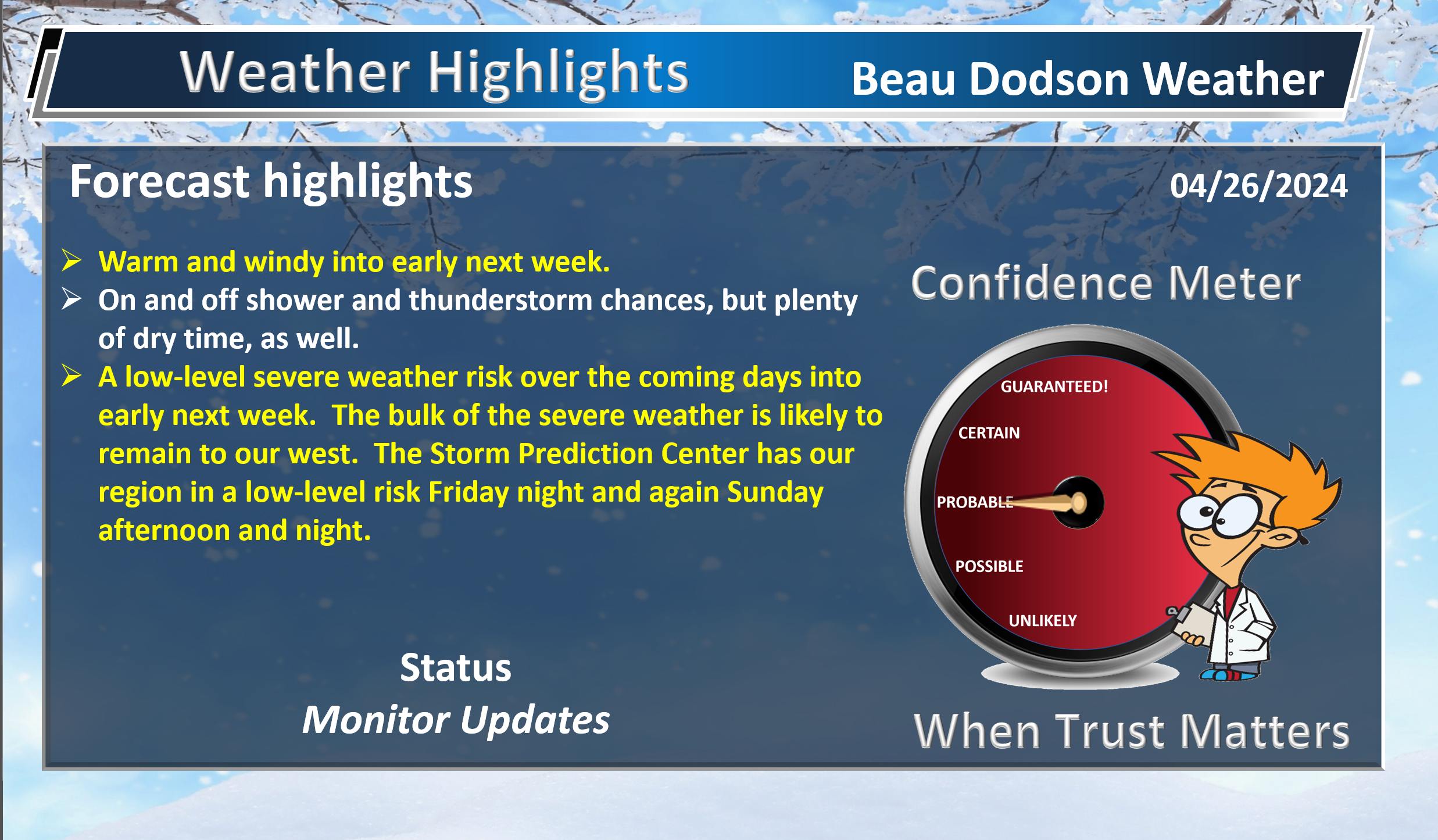
Seven Day Hazardous Weather Outlook
1. Is lightning in the forecast? YES. Lightning is possible today into Wednesday.
2. Are severe thunderstorms in the forecast? POSSIBLE (low end risk). A few thunderstorms could become severe into early next week.
There is a low-end risk Friday and Friday night. Mainly over southeast Missouri and perhaps southwest Illinois.
I am watching Sunday into Monday night.
All in all, the bulk of the severe weather is forecast to remain just to the west of our region. We will be in the low level risk zone. Higher probabilities farther west.
Monitor updates. See the severe weather outlooks farther down in the blog.
3. Is flash flooding in the forecast? NOT AT THIS TIME.
4. Will non-thunderstorm winds top 40 mph? POSSIBLE. Winds could top 40 mph Sunday.
5. Will the heat index exceed 100 degrees? NO.
6. Will the wind chill dip below 10 degrees? NO.
7. Is measurable snow and/or sleet in the forecast? NO.
8. Is freezing rain/ice in the forecast? NO.
Freezing rain is rain that falls and instantly freezes on objects such as trees and power lines Freezing fog possible, as well.
.

Fire weather risk level.
Friday through Friday night: 3. Very low risk.
Saturday: 3. Very low risk.
Saturday night: 3. Very low risk.
Fire Weather Discussion
Winds will become southerly throughout the day and then become the rule through the first half of next week. The weekend will be mainly dry for most of the region; however, the Mark Twain National Forest will be the exception with a chance of storms through the weekend. East of the Mark Twain, strong mixing will result in gusty south winds and afternoon relative humidity dropping to 40-50% Saturday and Sunday. Widespread wetting rains will move through the region Sunday night and Monday. Additional rain chances will arrive by the middle of next week.
A Haines Index of 6 means a high potential for an existing fire to become large or exhibit erratic fire behavior, 5 means medium potential, 4 means low potential, and anything less than 4 means very low potential.
.

THE FORECAST IS GOING TO VARY FROM LOCATION TO LOCATION.
Scroll down to see your local forecast details.
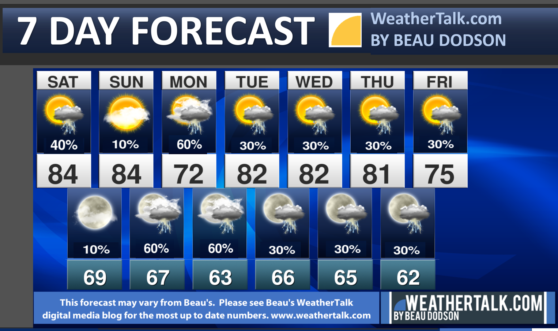
Seven-day forecast for southeast Missouri, southern Illinois, western Kentucky, and western Tennessee.
This is a BLEND for the region. Scroll down to see the region by region forecast.
48-hour forecast Graphics


.
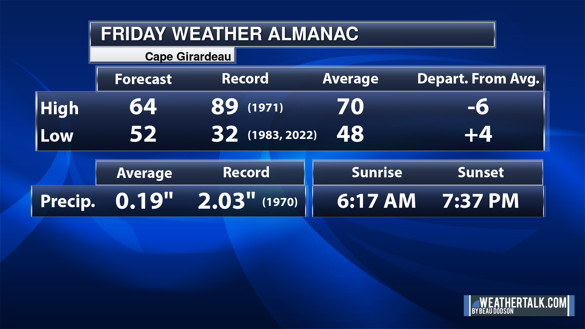
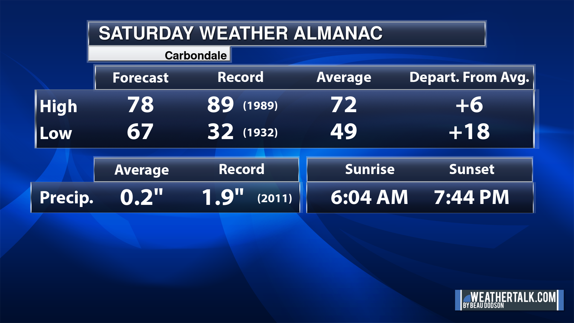
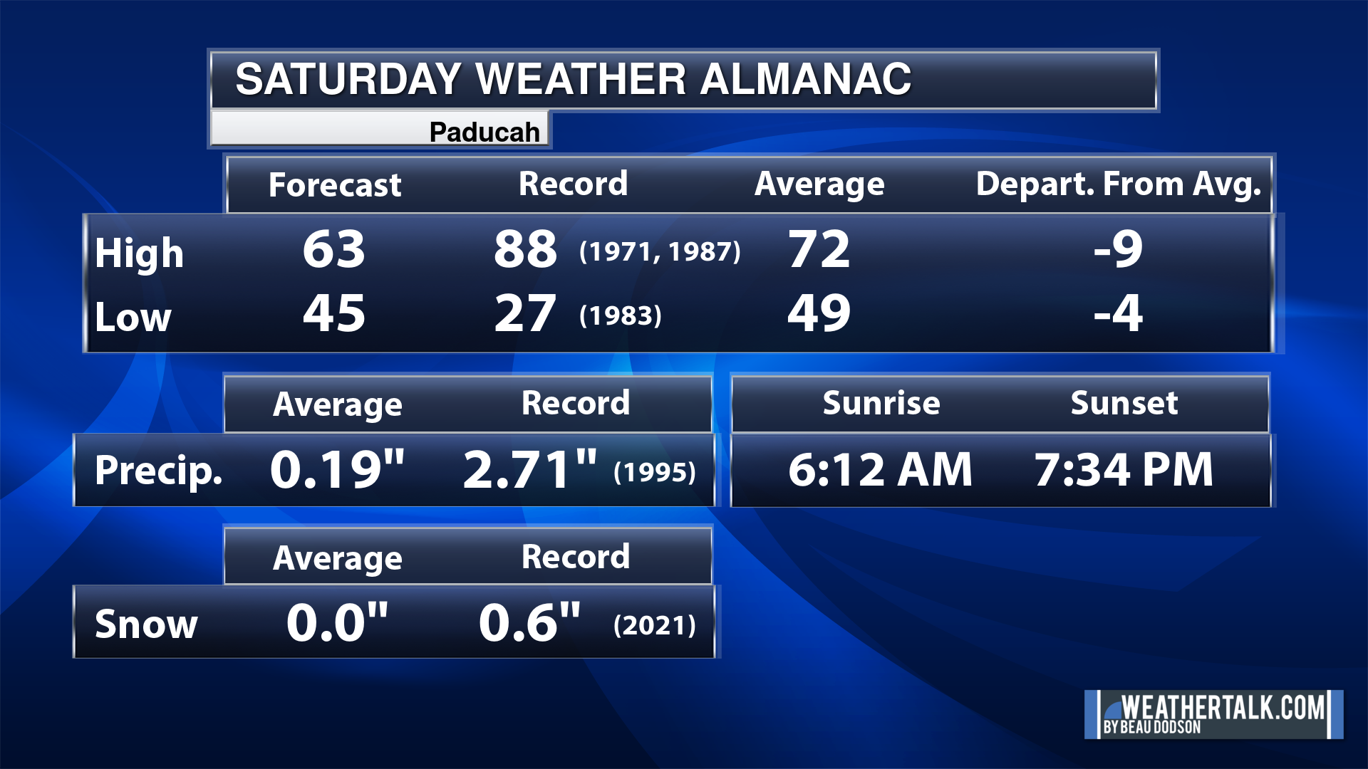
Today’s Local Almanacs (for a few select cities). Your location will be comparable.
Note, the low is this morning’s low and not tomorrows.
The forecast temperature shows you today’s expected high and this morning’s low.
The graphic shows you the record high and record low for today. It shows you what year that occurred, as well.
It then shows you what today’s average temperature is.
It shows you the departures (how may degrees above or below average temperatures will be ).
It shows you the average precipitation for today. Average comes from thirty years of rain totals.
It also shows you the record rainfall for the date and what year that occurred.
The sunrise and sunset are also shown.


![]()
.
.
Friday Forecast: A band of showers and thunderstorms will move through the region during the morning hours. Then, a chance of a few scattered showers and thunderstorms during the afternoon and evening hours. Chances will be higher the farther west you go this afternoon (into Missouri).
What is the chance of precipitation?
Far northern southeast Missouri ~ 60%
Southeast Missouri ~ 40%
The Missouri Bootheel ~ 40%
I-64 Corridor of southern Illinois ~ 40%
Southern Illinois ~ 40%
Extreme southern Illinois (southern seven counties) ~ 40%
Far western Kentucky (Purchase area) ~ 60%
The Pennyrile area of western KY ~ 60%
Northwest Kentucky (near Indiana border) ~ 60%
Northwest Tennessee ~ 30%
Coverage of precipitation: Scattered
Timing of the precipitation: Mainly during the morning hours. Moving southwest to northeast through the region. A band of showers.
Far northern southeast Missouri ~ 76° to 80°
Southeast Missouri ~ 76° to 80°
The Missouri Bootheel ~ 76° to 80°
I-64 Corridor of southern Illinois ~ 76° to 80°
Southern Illinois ~ 76° to 80°
Extreme southern Illinois (southern seven counties) ~ 76° to 80°
Far western Kentucky ~ 76° to 80°
The Pennyrile area of western KY ~ 76° to 80°
Northwest Kentucky (near Indiana border) ~ 76° to 80°
Northwest Tennessee ~ 76° to 80°
Winds will be from this direction: South 10 to 35 mph. Gusty.
Wind chill or heat index (feels like) temperature forecast: 76° to 80°
What impacts are anticipated from the weather? Wet roadways. Lightning. Monitor the risk of severe weather across mainly southeast Missouri and southwest Illinois.
Should I cancel my outdoor plans? No, but monitor the Beau Dodson Weather Radars
UV Index: 5. Moderate.
Sunrise: 6:06 AM
Sunset: 7:41 PM
.
Friday Night Forecast: Mostly cloudy. A chance of showers and thunderstorms. Once again, chances will be higher west and north vs southeast. A band of thunderstorms will approach southeast Missouri Friday afternoon and evening. With time, it will weaken as it moves farther east of the Mississippi River. See the future-cast radars farther down in the blog.
What is the chance of precipitation?
Far northern southeast Missouri ~ 60%
Southeast Missouri ~ 60%
The Missouri Bootheel ~ 60%
I-64 Corridor of southern Illinois ~ 60%
Southern Illinois ~ 60%
Extreme southern Illinois (southern seven counties) ~ 60%
Far western Kentucky (Purchase area) ~ 60%
The Pennyrile area of western KY ~ 40%
Northwest Kentucky (near Indiana border) ~ 40%
Northwest Tennessee ~ 30%
Coverage of precipitation: Scattered
Timing of the precipitation: Any given point of time
Temperature range:
Far northern southeast Missouri ~ 63° to 66°
Southeast Missouri ~ 63° to 66°
The Missouri Bootheel ~ 63° to 66°
I-64 Corridor of southern Illinois ~ 63° to 66°
Southern Illinois ~ 63° to 66°
Extreme southern Illinois (southern seven counties) ~ 63° to 66°
Far western Kentucky ~ 63° to 66°
The Pennyrile area of western KY ~ 63° to 66°
Northwest Kentucky (near Indiana border) ~ 63° to 66°
Northwest Tennessee ~ 63° to 66°
Winds will be from this direction: South 10 to 35 mph. Gusty.
Wind chill or heat index (feels like) temperature forecast: 63° to 66°
What impacts are anticipated from the weather? Wet roadways. Lightning. Monitor the risk of severe weather across mainly southeast Missouri and southwest Illinois.
Should I cancel my outdoor plans? No, but monitor the Beau Dodson Weather Radars
Moonrise: 10:52 PM
Moonset: 7:22 AM
The phase of the moon: Waning Gibbous
.
Saturday Forecast: A chance of showers and thunderstorms. Mainly during the morning hours.
What is the chance of precipitation?
Far northern southeast Missouri ~ 40%
Southeast Missouri ~ 60%
The Missouri Bootheel ~ 60%
I-64 Corridor of southern Illinois ~ 40%
Southern Illinois ~ 60%
Extreme southern Illinois (southern seven counties) ~ 60%
Far western Kentucky (Purchase area) ~ 60%
The Pennyrile area of western KY ~ 30%
Northwest Kentucky (near Indiana border) ~ 40%
Northwest Tennessee ~ 40%
Coverage of precipitation: Scattered
Timing of the precipitation: Any given point of time
Far northern southeast Missouri ~ 80° to 84°
Southeast Missouri ~ 80° to 84°
The Missouri Bootheel ~ 80° to 84°
I-64 Corridor of southern Illinois ~ 80° to 84°
Southern Illinois ~ 80° to 84°
Extreme southern Illinois (southern seven counties) ~ 80° to 84°
Far western Kentucky ~ 80° to 84°
The Pennyrile area of western KY ~ 80° to 84°
Northwest Kentucky (near Indiana border) ~ 80° to 84°
Northwest Tennessee ~80° to 84°
Winds will be from this direction: South 10 to 35 mph. Gusty.
Wind chill or heat index (feels like) temperature forecast: 80° to 84°
What impacts are anticipated from the weather? Wet roadways. Lightning.
Should I cancel my outdoor plans? No, but monitor the Beau Dodson Weather Radars
UV Index: 7. High
Sunrise: 6:04 AM
Sunset: 7:42 PM
.
Saturday Night Forecast: Mostly cloudy. A slight chance of showers and thunderstorms. Saturday night could end up completely dry.
What is the chance of precipitation?
Far northern southeast Missouri ~ 20%
Southeast Missouri ~ 20%
The Missouri Bootheel ~ 20%
I-64 Corridor of southern Illinois ~ 20%
Southern Illinois ~ 20%
Extreme southern Illinois (southern seven counties) ~ 10%
Far western Kentucky (Purchase area) ~ 10%
The Pennyrile area of western KY ~ 10%
Northwest Kentucky (near Indiana border) ~ 10%
Northwest Tennessee ~ 10%
Coverage of precipitation: Widely scattered
Timing of the precipitation: Any given point of time
Temperature range:
Far northern southeast Missouri ~ 63° to 66°
Southeast Missouri ~ 63° to 66°
The Missouri Bootheel ~ 63° to 66°
I-64 Corridor of southern Illinois ~ 63° to 66°
Southern Illinois ~ 63° to 66°
Extreme southern Illinois (southern seven counties) ~ 63° to 66°
Far western Kentucky ~ 63° to 66°
The Pennyrile area of western KY ~ 63° to 66°
Northwest Kentucky (near Indiana border) ~ 63° to 66°
Northwest Tennessee ~ 63° to 66°
Winds will be from this direction: South 10 to 30 mph. Gusty.
Wind chill or heat index (feels like) temperature forecast: 63° to 66°
What impacts are anticipated from the weather? Wet roadways. Lightning.
Should I cancel my outdoor plans? No, but monitor the Beau Dodson Weather Radars
Moonrise: 11:55 PM
Moonset: 8:06 AM
The phase of the moon: Waning Gibbous
.
Sunday Forecast: Mostly sunny. Warm and quite windy.
What is the chance of precipitation?
Far northern southeast Missouri ~ 20%
Southeast Missouri ~ 20%
The Missouri Bootheel ~ 20%
I-64 Corridor of southern Illinois ~ 10%
Southern Illinois ~ 10%
Extreme southern Illinois (southern seven counties) ~ 10%
Far western Kentucky (Purchase area) ~ 10%
The Pennyrile area of western KY ~ 10%
Northwest Kentucky (near Indiana border) ~ 10%
Northwest Tennessee ~ 10%
Coverage of precipitation:
Timing of the precipitation:
Far northern southeast Missouri ~ 83° to 86°
Southeast Missouri ~ 83° to 86°
The Missouri Bootheel ~ 83° to 86°
I-64 Corridor of southern Illinois ~ 83° to 86°
Southern Illinois ~ 83° to 86°
Extreme southern Illinois (southern seven counties) ~ 83° to 86°
Far western Kentucky ~ 83° to 86°
The Pennyrile area of western KY ~ 83° to 86°
Northwest Kentucky (near Indiana border) ~ 83° to 86°
Northwest Tennessee ~ 83° to 86°
Winds will be from this direction: South 20 to 40 mph. Gusty.
Wind chill or heat index (feels like) temperature forecast: 83° to 86°
What impacts are anticipated from the weather? A small chance of wet roadways and lightning.
Should I cancel my outdoor plans? No, but monitor the Beau Dodson Weather Radars
UV Index: 8. Very high.
Sunrise: 6:03 AM
Sunset: 7:43 PM
.
Sunday Night Forecast: Partly cloudy. A chance of showers and thunderstorms.
What is the chance of precipitation?
Far northern southeast Missouri ~ 70%
Southeast Missouri ~ 70%
The Missouri Bootheel ~ 70%
I-64 Corridor of southern Illinois ~ 70%
Southern Illinois ~ 60%
Extreme southern Illinois (southern seven counties) ~ 40%
Far western Kentucky (Purchase area) ~ 40%
The Pennyrile area of western KY ~ 30%
Northwest Kentucky (near Indiana border) ~ 30%
Northwest Tennessee ~ 40%
Coverage of precipitation: Numerous
Timing of the precipitation: Mainly after 6 pm.
Temperature range:
Far northern southeast Missouri ~ 63° to 66°
Southeast Missouri ~ 63° to 66°
The Missouri Bootheel ~ 63° to 66°
I-64 Corridor of southern Illinois ~ 63° to 66°
Southern Illinois ~ 63° to 66°
Extreme southern Illinois (southern seven counties) ~ 63° to 66°
Far western Kentucky ~ 63° to 66°
The Pennyrile area of western KY ~ 63° to 66°
Northwest Kentucky (near Indiana border) ~ 63° to 66°
Northwest Tennessee ~ 63° to 66°
Winds will be from this direction: South 10 to 30 mph. Gusty.
Wind chill or heat index (feels like) temperature forecast: 63° to 66°
What impacts are anticipated from the weather? Wet roadways. Lightning. Monitor the risk of severe weather.
Should I cancel my outdoor plans? No, but monitor the Beau Dodson Weather Radars
Moonrise:
Moonset: 9:00 AM
The phase of the moon: Waning Gibbous
.
Monday Forecast: Mostly cloudy with showers and thunderstorms likely.
What is the chance of precipitation?
Far northern southeast Missouri ~ 70%
Southeast Missouri ~ 70%
The Missouri Bootheel ~ 70%
I-64 Corridor of southern Illinois ~ 70%
Southern Illinois ~ 70%
Extreme southern Illinois (southern seven counties) ~ 70%
Far western Kentucky (Purchase area) ~ 70%
The Pennyrile area of western KY ~ 70%
Northwest Kentucky (near Indiana border) ~ 70%
Northwest Tennessee ~ 70%
Coverage of precipitation: Numerous
Timing of the precipitation: Any given point of time
Far northern southeast Missouri ~ 73° to 76°
Southeast Missouri ~ 73° to 76°
The Missouri Bootheel ~ 73° to 76°
I-64 Corridor of southern Illinois ~ 73° to 76°
Southern Illinois ~ 73° to 76°
Extreme southern Illinois (southern seven counties) ~ 73° to 76°
Far western Kentucky ~ 73° to 76°
The Pennyrile area of western KY ~ 73° to 76°
Northwest Kentucky (near Indiana border) ~ 73° to 76°
Northwest Tennessee ~ 73° to 76°
Winds will be from this direction: South 10 to 25 mph. Gusty.
Wind chill or heat index (feels like) temperature forecast: 73° to 76°
What impacts are anticipated from the weather? Wet roadways and lightning.
Should I cancel my outdoor plans? Have a plan B and monitor updated forecasts and radars.
UV Index: 5. Moderate
Sunrise: 6:02 AM
Sunset: 7:44 PM
.
Monday Night Forecast: Mostly cloudy. A chance of showers and thunderstorms.
What is the chance of precipitation?
Far northern southeast Missouri ~ 40%
Southeast Missouri ~ 40%
The Missouri Bootheel ~ 40%
I-64 Corridor of southern Illinois ~ 60%
Southern Illinois ~ 60%
Extreme southern Illinois (southern seven counties) ~ 60%
Far western Kentucky (Purchase area) ~ 60%
The Pennyrile area of western KY ~ 70%
Northwest Kentucky (near Indiana border) ~ 60%
Northwest Tennessee ~ 40%
Coverage of precipitation: Numerous early. Tapering west to east overnight.
Timing of the precipitation: Any given point of time.
Temperature range:
Far northern southeast Missouri ~ 55° to 60°
Southeast Missouri ~ 55° to 60°
The Missouri Bootheel ~ 55° to 60°
I-64 Corridor of southern Illinois ~ 55° to 60°
Southern Illinois ~ 55° to 60°
Extreme southern Illinois (southern seven counties) ~ 55° to 60°
Far western Kentucky ~ 55° to 60°
The Pennyrile area of western KY ~ 55° to 60°
Northwest Kentucky (near Indiana border) ~ 55° to 60°
Northwest Tennessee ~ 55° to 60°
Winds will be from this direction: South southwest 7 to 14 mph.
Wind chill or heat index (feels like) temperature forecast: 55° to 60°
What impacts are anticipated from the weather? Wet roadways. Lightning.
Should I cancel my outdoor plans? No, but monitor the Beau Dodson Weather Radars
Moonrise: 12:52 AM
Moonset: 10:00 AM
The phase of the moon: Waning Gibbous
.
Tuesday Forecast: Partly cloudy with a slight chance of showers and thunderstorms.
What is the chance of precipitation?
Far northern southeast Missouri ~ 20%
Southeast Missouri ~ 20%
The Missouri Bootheel ~ 20%
I-64 Corridor of southern Illinois ~ 20%
Southern Illinois ~ 20%
Extreme southern Illinois (southern seven counties) ~ 20%
Far western Kentucky (Purchase area) ~ 20%
The Pennyrile area of western KY ~ 20%
Northwest Kentucky (near Indiana border) ~ 20%
Northwest Tennessee ~ 20%
Coverage of precipitation: Isolated
Timing of the precipitation: Any given point of time
Far northern southeast Missouri ~ 80° to 84°
Southeast Missouri ~ 80° to 84°
The Missouri Bootheel ~ 80° to 84°
I-64 Corridor of southern Illinois ~ 80° to 84°
Southern Illinois ~ 80° to 84°
Extreme southern Illinois (southern seven counties) ~ 80° to 84°
Far western Kentucky ~ 80° to 84°
The Pennyrile area of western KY ~ 80° to 84°
Northwest Kentucky (near Indiana border) ~ 80° to 84°
Northwest Tennessee ~ 80° to 84°
Winds will be from this direction: South southwest 7 to 14 mph with higher gusts.
Wind chill or heat index (feels like) temperature forecast: 80° to 84°
What impacts are anticipated from the weather? Wet roadways and lightning.
Should I cancel my outdoor plans? No, but monitor the radars.
UV Index: 8. Very high.
Sunrise: 6:01 AM
Sunset: 7:45 PM
.
Tuesday Night Forecast: Partly cloudy. A slight chance of showers and thunderstorms.
What is the chance of precipitation?
Far northern southeast Missouri ~ 20%
Southeast Missouri ~ 20%
The Missouri Bootheel ~ 20%
I-64 Corridor of southern Illinois ~ 20%
Southern Illinois ~ 20%
Extreme southern Illinois (southern seven counties) ~ 20%
Far western Kentucky (Purchase area) ~ 20%
The Pennyrile area of western KY ~ 20%
Northwest Kentucky (near Indiana border) ~ 20%
Northwest Tennessee ~ 20%
Coverage of precipitation: Isolated
Timing of the precipitation: Any given point of time.
Temperature range:
Far northern southeast Missouri ~ 62° to 65°
Southeast Missouri ~ 62° to 65°
The Missouri Bootheel ~ 62° to 65°
I-64 Corridor of southern Illinois ~ 62° to 65°
Southern Illinois ~ 62° to 65°
Extreme southern Illinois (southern seven counties) ~ 62° to 65°
Far western Kentucky ~ 62° to 65°
The Pennyrile area of western KY ~ 62° to 65°
Northwest Kentucky (near Indiana border) ~ 62° to 65°
Northwest Tennessee ~ 62° to 65°
Winds will be from this direction: South southwest 7 to 14 mph.
Wind chill or heat index (feels like) temperature forecast: 62° to 65°
What impacts are anticipated from the weather? Wet roadways. Lightning.
Should I cancel my outdoor plans? No, but monitor the Beau Dodson Weather Radars
Moonrise: 1:41 AM
Moonset: 11:10 Am
The phase of the moon: Waning Gibbous
.
Click here if you would like to return to the top of the page.

-
- Warm, windy, and more humid.
- Scattered shower and thunderstorm chances into next week. Plenty of dry time, as well. A few storms could be on the intense side.
- Winds Sunday could top 40 mph.
Weather advice:
Do you have any suggestions or comments? Email me at beaudodson@usawx.com
Make sure you have three to five ways of receiving your severe weather information.
Weather Talk is one of those ways.

.
Beau’s Forecast Discussion
Good morning,
We are waking up to scattered showers and thunderstorms in the region. A band of precipitation was moving east northeast through the region.
Here are the early morning radar view of those showers.
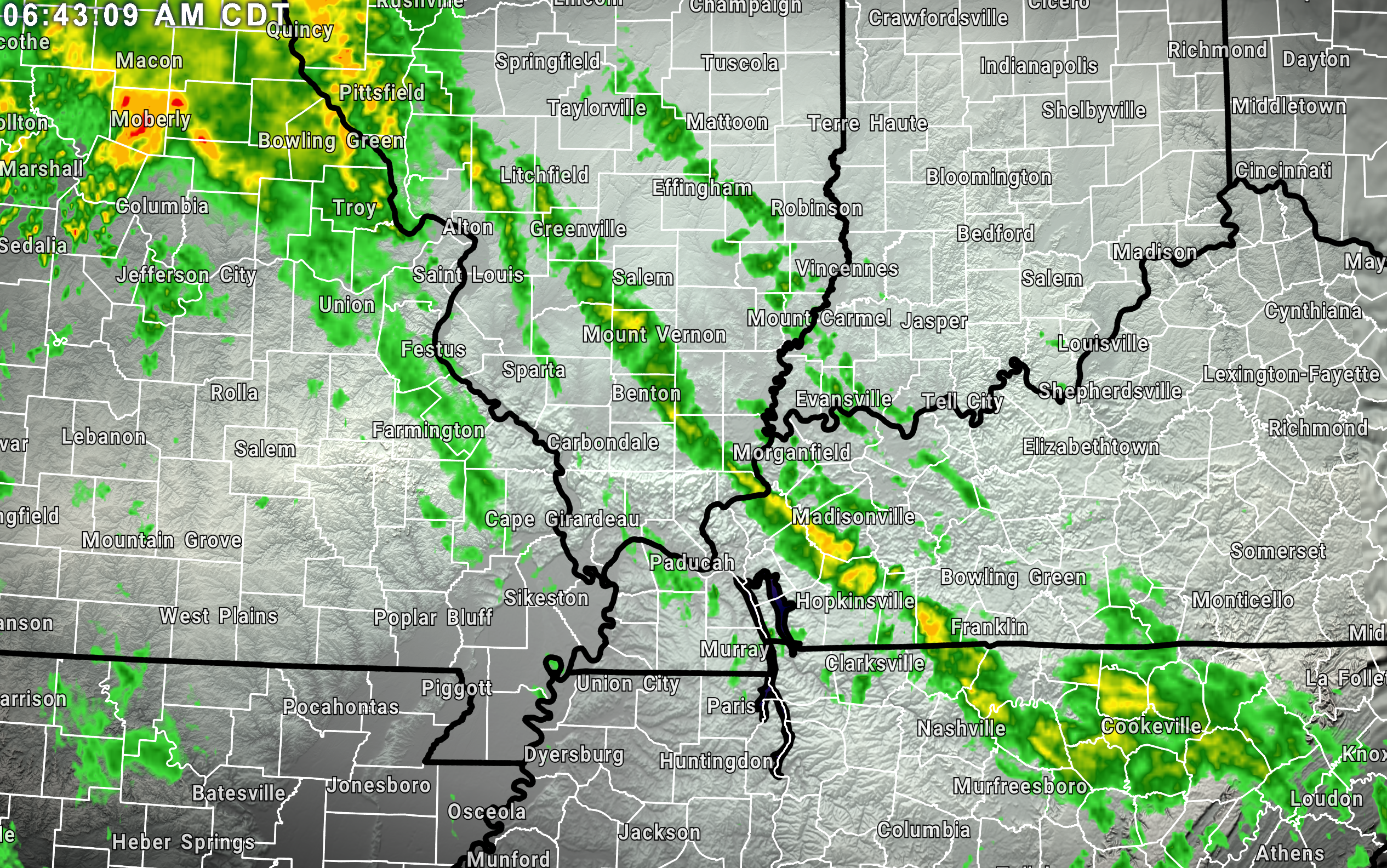
That precipitation will push out of the region as we move through the morning hours.
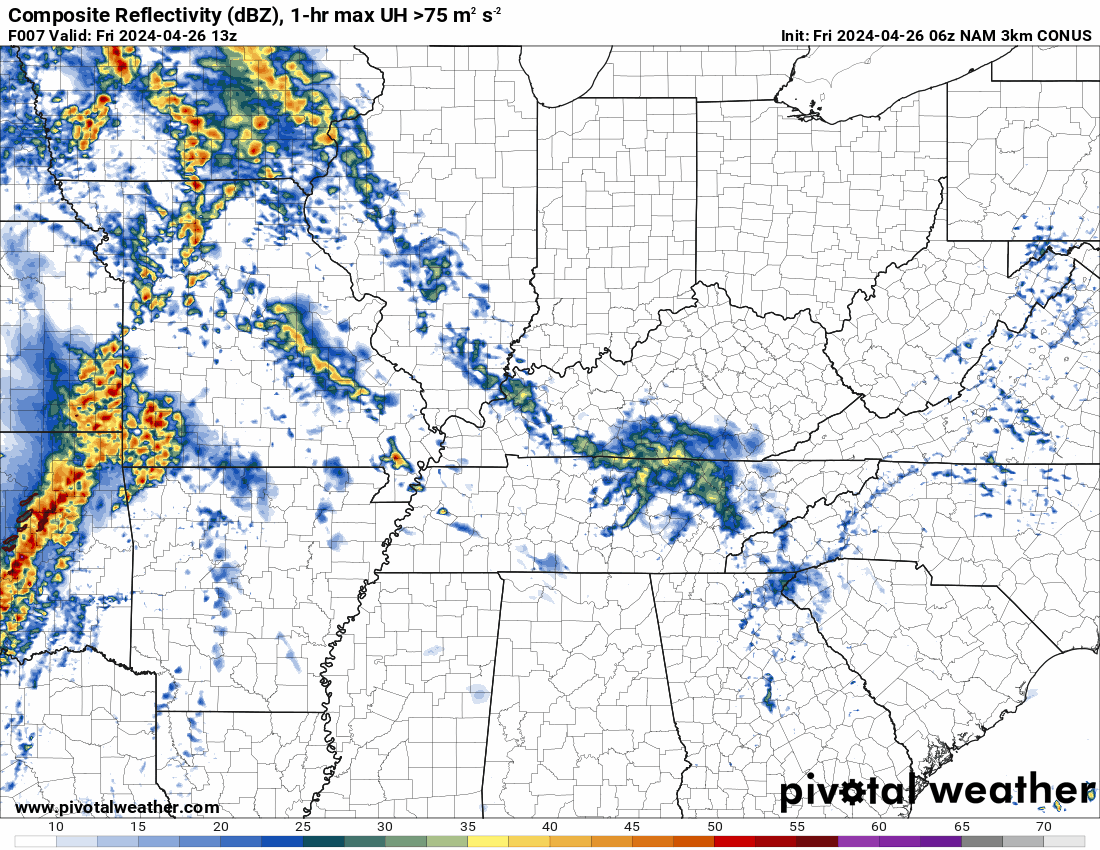
Then, we will monitor a band of showers and thunderstorms over Kansas and Oklahoma. You can already see that this morning on the radar. It is moving east northeast. With time, it will weaken.
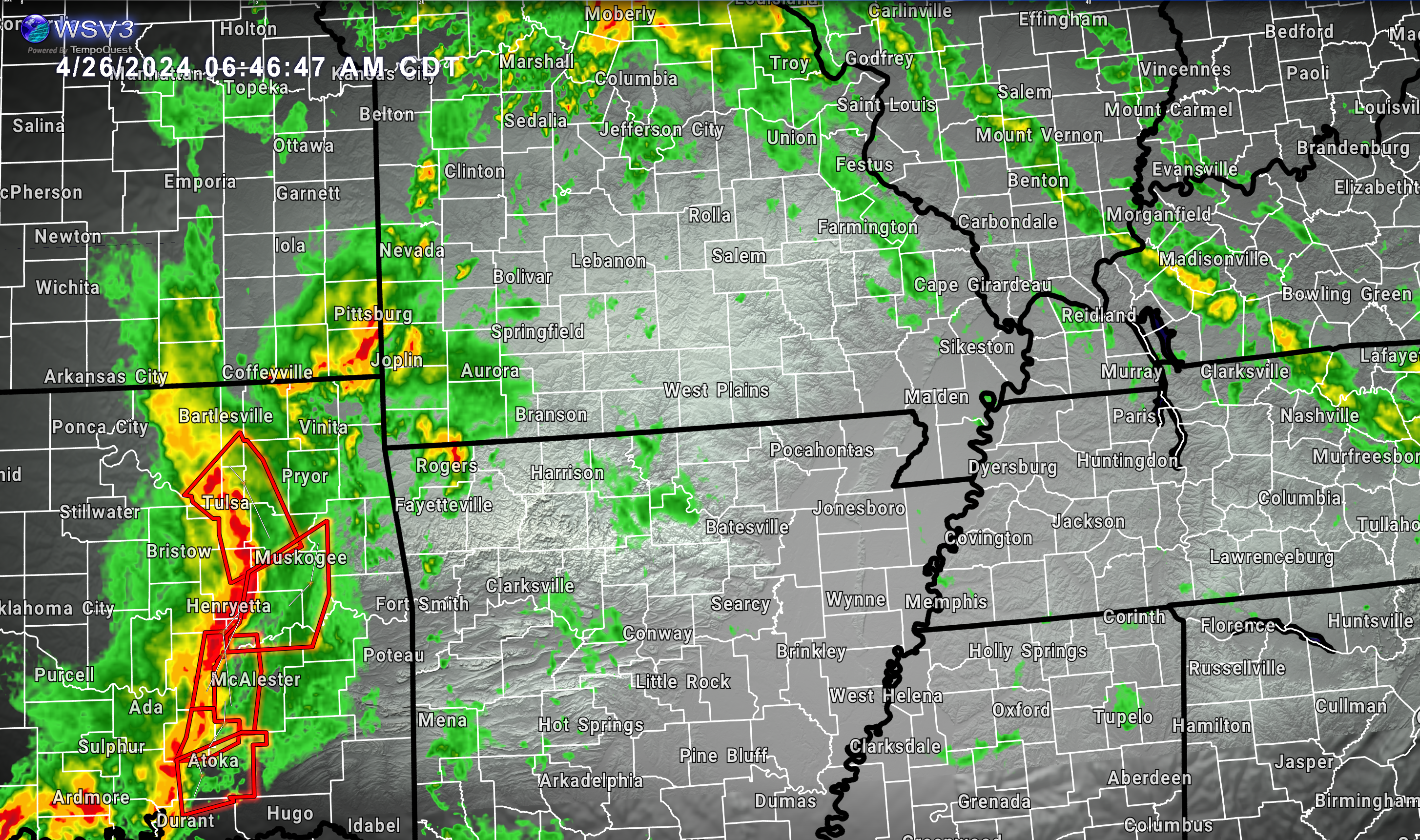
The Storm Prediction Center does have southeast Missouri and a sliver of southwest Illinois in a low level risk of severe thunderstorms this afternoon and tonight. All in all, instability and wind shear is lacking. I don’t expect much.
The yellow is a slight risk (level 2). The dark green is a marginal risk (level 1). The light green is where thunderstorms are possible, but likely to remain below severe levels.

If a warning were to be issued, then it would be for damaging wind and perhaps hail. Again, the threat appears to be on the lower end of the spectrum.
The band of showers and thunderstorms will approach the Mississippi River this evening and as it moves farther east, it will continue to weaken.
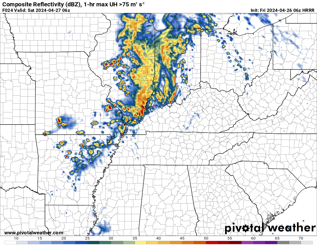
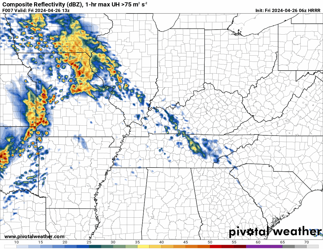
You can see that on the high resolution Hrrr model.
Future-cast radars. What radar might look like this evening.
7 PM
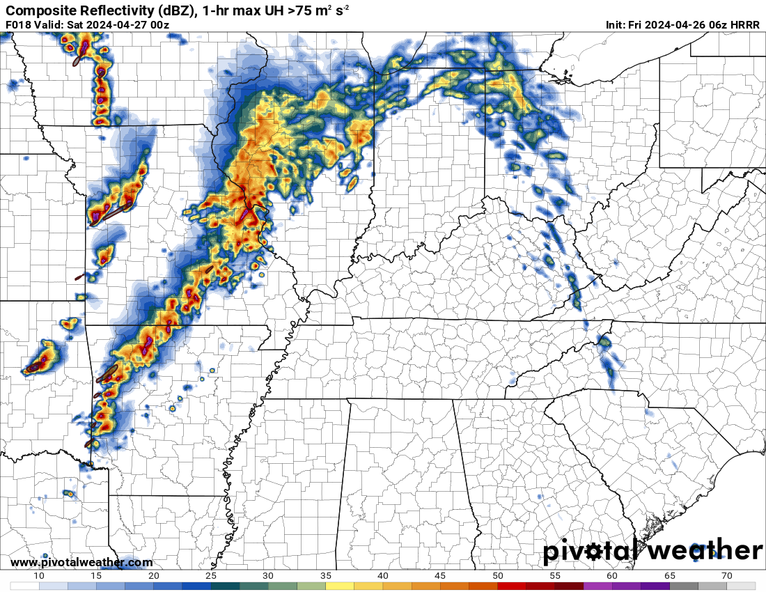
10 PM
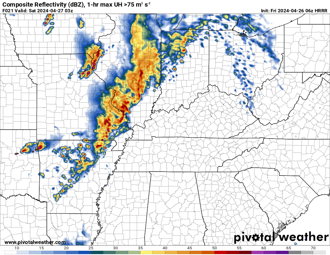
1 AM future-cast radar. You can see the line is weakening.
It will be warm and windy today into Monday. Winds could top 40 mph Sunday and Sunday evening.
Saturday and Saturday night will deliver a couple of showers and thunderstorms during the daytime, but Saturday night should be dry or mostly dry. An isolated shower or thunderstorm, at best.
I would not cancel any weekend plans. I would monitor updated forecasts and radars.
A cold front will push into the region Sunday and Sunday night. Sunday will likely be mostly dry. Again, warm and windy.
Shower and thunderstorm chances will increase Sunday night into Monday night. Numerous showers and thunderstorms are anticipated.
I can’t rule out a few intense thunderstorms Sunday afternoon and night. The overall risk of severe weather appears limited, but not zero.
Once again, damaging wind would be the primary threat. Perhaps a few reports of hail. The tornado risk is low.
Monitor updates, as always. I will send out app messages if severe weather develops. I will send out updates, as well if adjustments in the severe weather outlooks are necessary.
Model data diverges as we move into Tuesday, Wednesday, and Thursday. For now, confidence is rather low in the outcome. I did keep low-end shower and thunderstorm chances in the forecast, but I will monitor trends in the data. It is possible that it ends up drier.
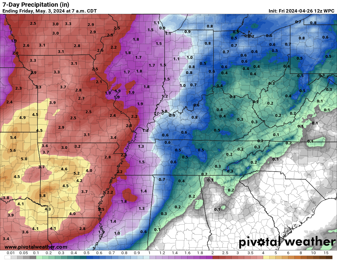
Either way, between now and next Tuesday, many areas will pick up 0.7″ to 1.40″ of rain. Locally higher totals are possible. Thunderstorms can always increase totals, especially if you end up under multiple storms.
Here is what NOAA is painting for rainfall totals. They have been running high over the last six months. The final solutions have tended to be a bit lower.
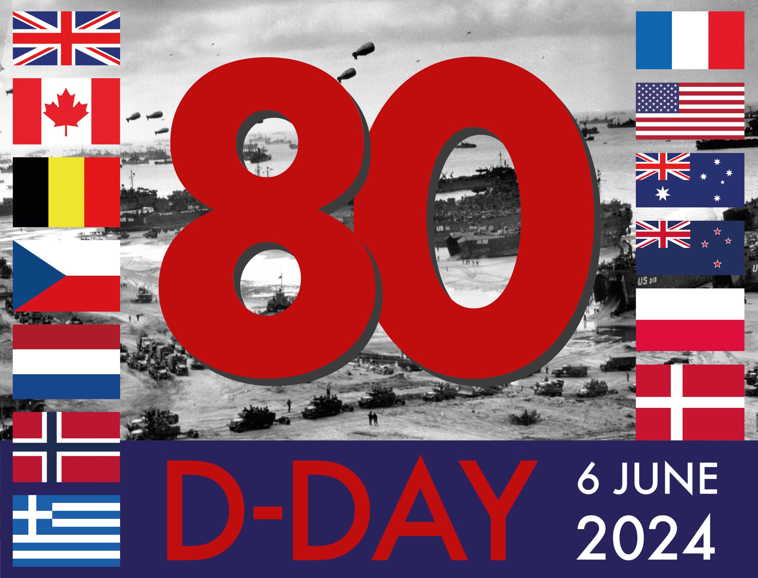
—-> I will be off work the first week of June.
I am taking my dad to Normandy, France for the 80th anniversary of D-Day. During that time, I will be away from the computer. Just a heads up!
My Great Uncle, Robert Dodson, was a meteorologist who parachuted in to forecast for D-Day and Operation Overlord. We are going over to commemorate the event.


Staff Sergeant Robert A. Dodson enlisted in the Army in August 1941 and trained as a weather observer at New Orleans Army Bomber Base in September 1941.
In April 1944, Sergeant Dodson was assigned to the 21st Weather Squadron in Ascot, England and a month later he volunteered jump school training. As his paperwork was being processed, the jump school was shut down in preparation for “D-Day”. Undaunted, Sergeant Dodson and his commanding officer convinced the 82nd Airborne Division, located at Manchester, England, to make room for one more soldier. Sergeant Dodson became a member of an Air Support Party from Ninth Air Force attached to Headquarters, 82nd Airborne Division, which consisted of an Officer in Charge, five communications men who acted as forward air controllers, a driver, and a weather observer, equipped with a half-track and a “veep” (radio equipped jeep). Sergeant Dodson received a minimum of mock-up training before making his first and only jump.
At 0230hrs on 6 June 1944, Sergeant Dodson jumped with Force “A” of the 82nd Airborne Division commanded by Brigadier General James M. Gavin. The sky was moonlit and practically clear when he landed about a mile northeast of St. Mere Eglise, France in a field where cattle were grazing. One other man had landed in the same field with him and the two of them set out at once toward the head of the stick, in spite of a knee injury Sergeant Dodson sustained during the jump. As they proceeded they picked up eight other members of their outfit one at a time. Things were progressing according to schedule and they had yet to make contact with the enemy. They found three injured men along the way, gave them first aid, and continued on. Along the way they recovered their equipment which they unpacked, selected a VHF radio, and camouflaged the rest of the equipment in a hedgerow before finally linking up with the command post which had relocated to St. Mere Eglise.
The Germans counterattacked, and during thirty-six hours all members of the Air Support Party acted as riflemen. When the siege was lifted, Sergeant Dodson began his weather observing duties. Each hour he sent by radio the present weather, wind direction and speed, visibility, ceiling and cloud heights, temperature, and dew point. For the last elements he was equipped with a shielded psychrometer and psychometric tables, while all other elements were determined visually. This work continued until 21 June, when Sergeant Dodson was evacuated to the hospital at Bouteville for treatment on the knee he injured during the jump. He later returned to his unit, which returned to England when it was relieved on 13 July. Sergeant Dodson, who made his first trip to France during the war with a parachute as a weather observer with the 82nd Airborne Division, returned to France with the headquarters of Ninth Air Force and the 21st Weather Squadron, serving out the rest of the war as chief dispatcher at the motor pool. He left the service in September 1945.
Sergeant Dodson’s military decorations include the Bronze Star Medal, Purple Heart, Europe-Africa-Middle East Campaign medal with 4 bronze service stars (for the Normandy, Northern France, Rhineland and Central Europe campaigns), American Defense Service Medal, and Distinguished Unit Citation. The Air Weather Service recognized Sergeant Dodson’s World War II service in July 1987 by naming its Specialized Support Award in his honor.
![]()
.
Click here if you would like to return to the top of the page.
This outlook covers southeast Missouri, southern Illinois, western Kentucky, and far northwest Tennessee.

.
Today’s Storm Prediction Center’s (SPC) Severe Weather Outlook
Light green is where thunderstorms may occur but should be below severe levels.
Dark green is a level one risk. Yellow is a level two risk. Orange is a level three (enhanced) risk. Red is a level four (moderate) risk. Pink is a level five (high) risk.
One is the lowest risk. Five is the highest risk.
A severe storm is one that produces 58 mph wind or higher, quarter or larger size hail, and/or a tornado.
Explanation of tables. Click here.
Day One Severe Weather Outlook

Day One Severe Weather Outlook. Zoomed in on our region.
.
Day One Tornado Probability Outlook

Day One Regional Tornado Outlook. Zoomed in on our region.

.
Day One Large Hail Probability Outlook

Day One Regional Hail Outlook. Zoomed in on our region.

.
Day One High wind Probability Outlook

Day One Regional Wind Outlook. Zoomed in on our region.

.
Tomorrow’s severe weather outlook. Day two outlook.

Day Two Outlook. Zoomed in on our region.

.
Day Three Severe Weather Outlook

.

.
The images below are from NOAA’s Weather Prediction Center.
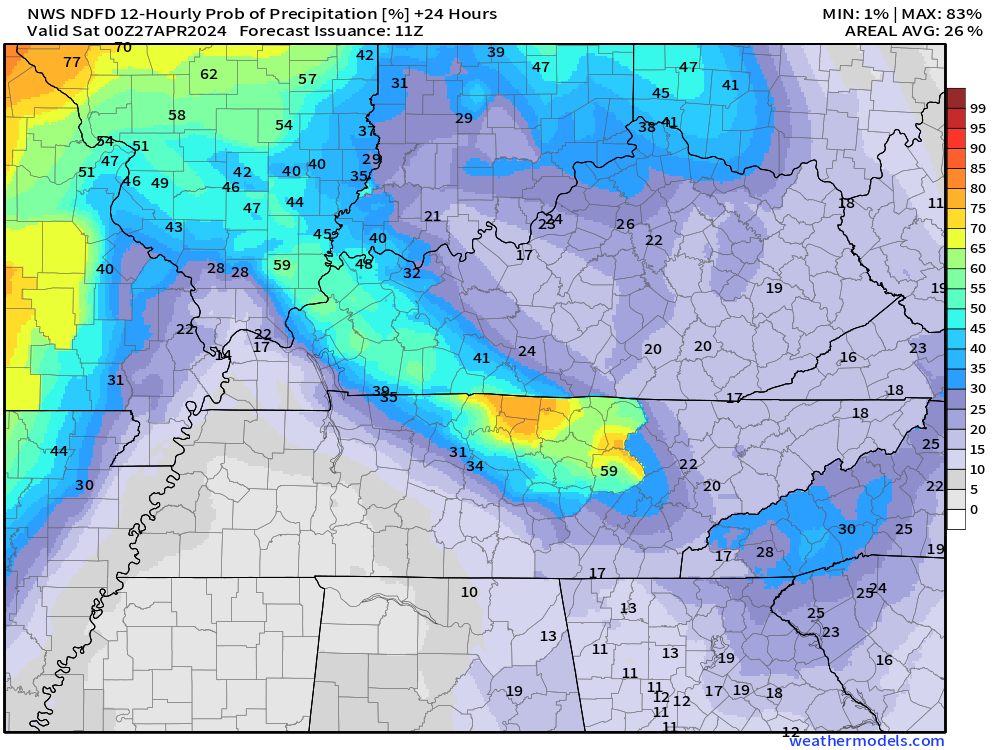
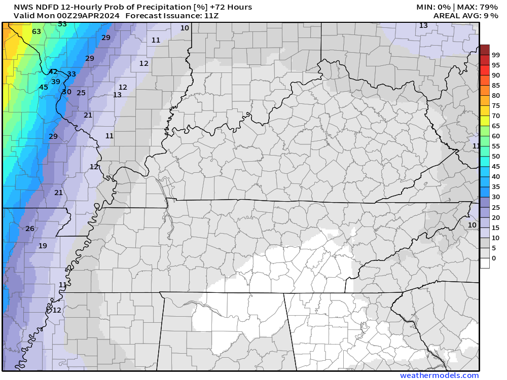
24-hour precipitation outlook..
 .
.
.
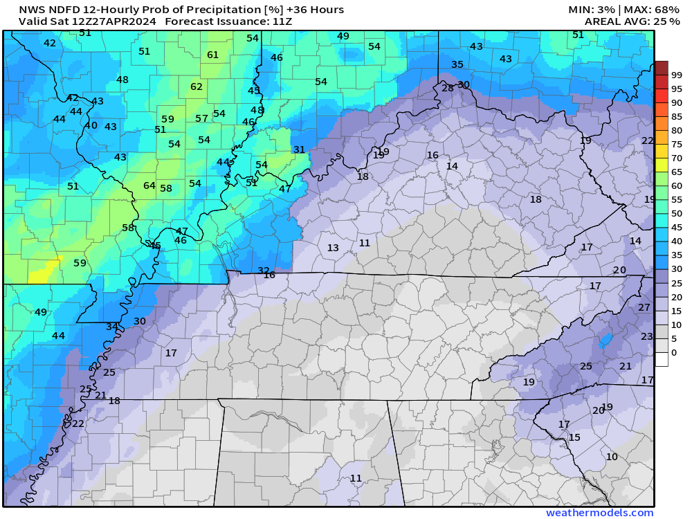
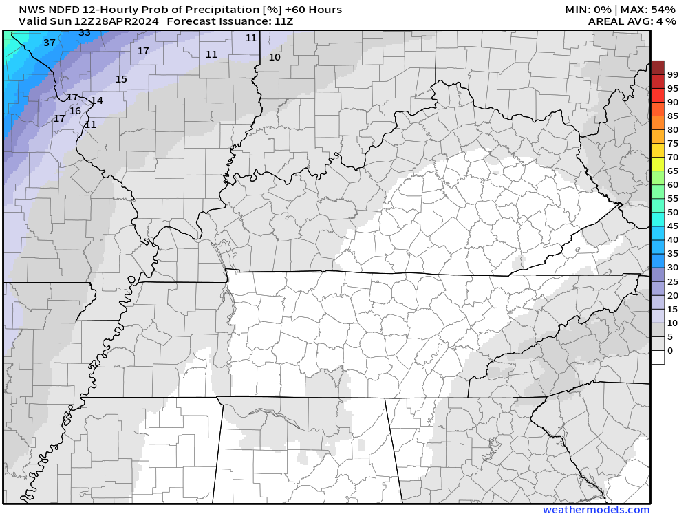
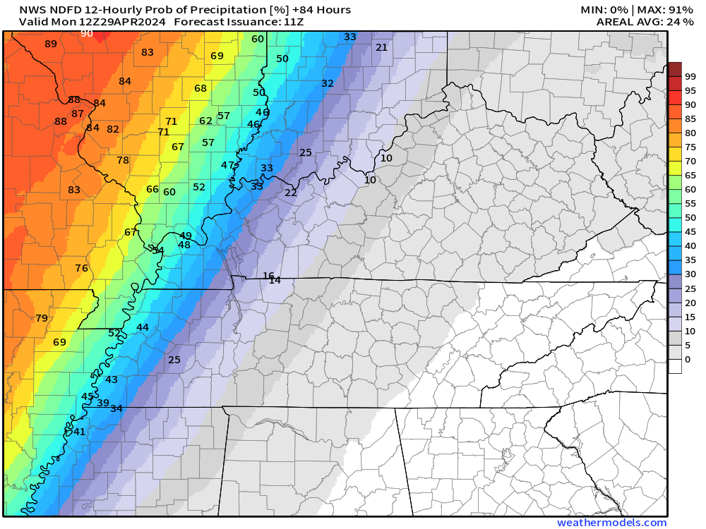
48-hour precipitation outlook.
. .
.
![]()
_______________________________________
.

Click here if you would like to return to the top of the page.
Again, as a reminder, these are models. They are never 100% accurate. Take the general idea from them.
What should I take from these?
- The general idea and not specifics. Models usually do well with the generalities.
- The time-stamp is located in the upper left corner.
.
What am I looking at?
You are looking at computer model data. Meteorologists use many different models to forecast the weather.
Occasionally, these maps are in Zulu time. 12z=7 AM. 18z=1 PM. 00z=7 PM. 06z=1 AM
Green represents light rain. Dark green represents moderate rain. Yellow and orange represent heavier rain.
.
This animation is the NAM 3K Model.
This graphic shows you what this particular model believes the radar may look like. Each model may be a little different. The more models that agree, the higher the confidence in the forecast outcome.
Occasionally, these maps are in Zulu time. 12z=7 AM. 18z=1 PM. 00z=7 PM. 06z=1 AM
Double click images to enlarge them.
.
This animation is the FV3 Model.
This graphic shows you what this particular model believes the radar may look like. Each model may be a little different. The more models that agree, the higher the confidence in the forecast outcome.
Green is rain. Yellow and orange are heavier rain. Pink is a wintry mix. Blue is snow. Dark blue is heavier snow.
Occasionally, these maps are in Zulu time. 12z=7 AM. 18z=1 PM. 00z=7 PM. 06z=1 AM
Double click images to enlarge them.
.
This animation is the HRRR Model.
This graphic shows you what this particular model believes the radar may look like. Each model may be a little different. The more models that agree, the higher the confidence in the forecast outcome.
Green is rain. Yellow and orange are heavier rain. Pink is a wintry mix. Blue is snow. Dark blue is heavier snow.
Occasionally, these maps are in Zulu time. 12z=7 AM. 18z=1 PM. 00z=7 PM. 06z=1 AM
Double click images to enlarge them.
.
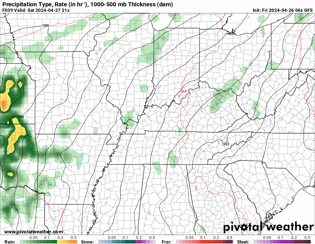
This animation is the GFS Model.
This graphic shows you what this particular model believes the radar may look like. Each model may be a little different. The more models that agree, the higher the confidence in the forecast outcome.
Green is rain. Yellow and orange are heavier rain. Pink is a wintry mix. Blue is snow. Dark blue is heavier snow.
Occasionally, these maps are in Zulu time. 12z=7 AM. 18z=1 PM. 00z=7 PM. 06z=1 AM
Double click images to enlarge them.
.
This animation is the EC Model.
This graphic shows you what this particular model believes the radar may look like. Each model may be a little different. The more models that agree, the higher the confidence in the forecast outcome.
Green is rain. Yellow and orange are heavier rain. Pink is a wintry mix. Blue is snow. Dark blue is heavier snow.
Occasionally, these maps are in Zulu time. 12z=7 AM. 18z=1 PM. 00z=7 PM. 06z=1 AM
Double click images to enlarge them.
.
..![]()

.
Click here if you would like to return to the top of the page.
.Average high temperatures for this time of the year are around 66 degrees.
Average low temperatures for this time of the year are around 44 degrees.
Average precipitation during this time period ranges from 0.80″ to 1.60″
Six to Ten Day Outlook.
Blue is below average. Red is above average. The no color zone represents equal chances.
Average highs for this time of the year are in the lower 60s. Average lows for this time of the year are in the lower 40s.

Green is above average precipitation. Yellow and brown favors below average precipitation. Average precipitation for this time of the year is around one inch per week.

.

Average low temperatures for this time of the year are around 45 degrees.
Average precipitation during this time period ranges from 0.80″ to 1.60″
.
Eight to Fourteen Day Outlook.
Blue is below average. Red is above average. The no color zone represents equal chances.

Green is above average precipitation. Yellow and brown favors below average precipitation. Average precipitation for this time of the year is around one inch per week.

.
![]()
The app is for subscribers. Subscribe at www.weathertalk.com/welcome then go to your app store and search for WeatherTalk
Subscribers, PLEASE USE THE APP. ATT and Verizon are not reliable during severe weather. They are delaying text messages.
The app is under WeatherTalk in the app store.

Apple users click here

Android users click here
.

Radars and Lightning Data
Interactive-city-view radars. Clickable watches and warnings.
https://wtalk.co/B3XHASFZ
If the radar is not updating then try another one. If a radar does not appear to be refreshing then hit Ctrl F5. You may also try restarting your browser.
Backup radar site in case the above one is not working.
https://weathertalk.com/morani
Regional Radar
https://imagery.weathertalk.com/prx/RadarLoop.mp4
** NEW ** Zoom radar with chaser tracking abilities!
ZoomRadar
Lightning Data (zoom in and out of your local area)
https://wtalk.co/WJ3SN5UZ
Not working? Email me at beaudodson@usawx.com
National map of weather watches and warnings. Click here.
Storm Prediction Center. Click here.
Weather Prediction Center. Click here.
.

Live lightning data: Click here.
Real time lightning data (another one) https://map.blitzortung.org/#5.02/37.95/-86.99
Our new Zoom radar with storm chases
.
.

Interactive GOES R satellite. Track clouds. Click here.
GOES 16 slider tool. Click here.
College of DuPage satellites. Click here
.

Here are the latest local river stage forecast numbers Click Here.
Here are the latest lake stage forecast numbers for Kentucky Lake and Lake Barkley Click Here.
.
.
Find Beau on Facebook! Click the banner.


 .
.