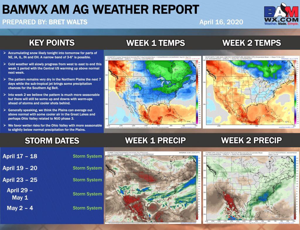
.
Click one of the links below to take you directly to that section.
Do you have any suggestions or comments? Email me at beaudodson@usawx.com
7-day forecast for southeast Missouri, southern Illinois, western Kentucky, and western Tennessee.
This is a broad-brush of the region. See my detailed hand-typed forecast further down.
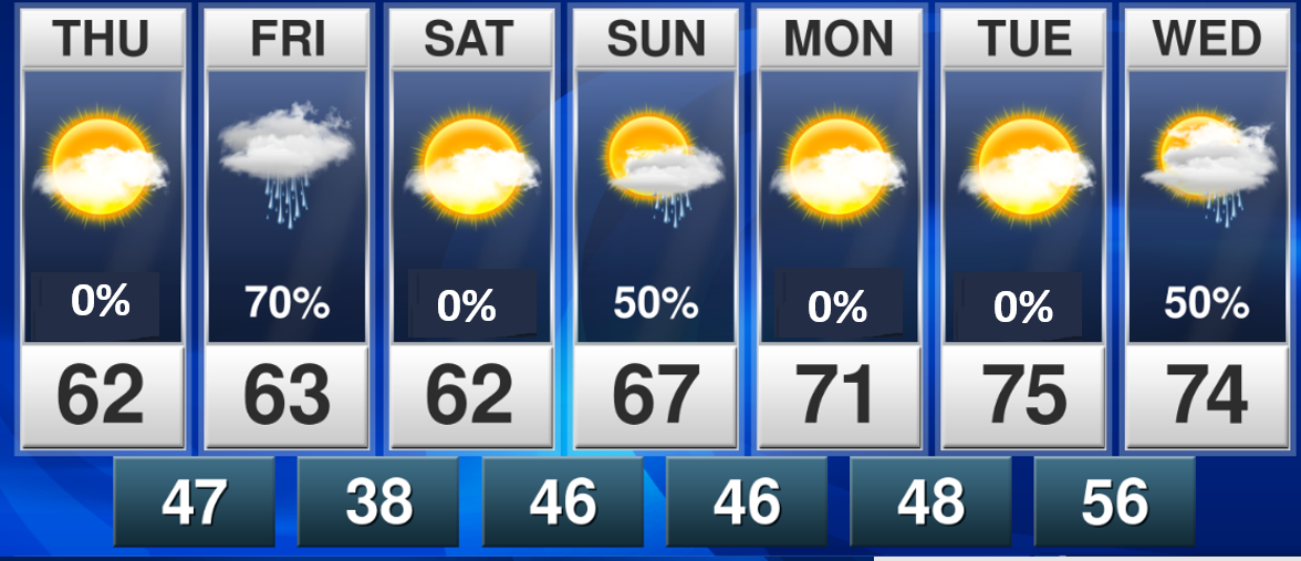


Thursday to Thursday
1. Is lightning in the forecast? Monitor. I will be monitoring Friday. Isolated lightning. Lightning is possible next Wednesday.
2. Are severe thunderstorms in the forecast? Not at this time. I will monitor next Wednesday.
* The NWS officially defines a severe thunderstorm as a storm with 58 mph wind or greater, 1″ hail or larger, and/or tornadoes
3. Is flash flooding in the forecast? No. Locally heavy rain is possible next Wednesday. For now, this does not appear to be enough rain for flooding.
4. Will there be a chance of a frost or freeze? Possible. Another chance of frost on Saturday morning.

Something wrong on the page? Suggestions? Email me at beaudodson@usawx.com
.
.. .
.
.
April 16, 2020
How confident am I that this days forecast will verify? High confidence
Thursday Forecast: Partly sunny. Patchy morning frost is possible.
What is the chance of precipitation? MO ~ 0% IL ~ 0% KY ~ 0% TN ~ 0%
Temperature range: MO Bootheel 63° to 65° SE MO 60° to 64° South IL 58° to 62° Northwest KY (near Indiana border) 56° to 60° West KY 60° to 64° NW TN 62° to 65°
Wind direction and speed: East and southeast at 6 to 12 mph with gusts to 20 mph this afternoon.
Wind chill or heat index (feels like) temperature forecast: 58° to 62°
Coverage of precipitation: None
What impacts are anticipated from the weather? Patchy morning frost.
Should I cancel my outdoor plans? No
UV Index: 8. Very high
Sunrise: 6:18 AM
Sunset: 7:32 PM
.
Thursday night Forecast: Increasing clouds. Cool. A chance of showers approaching from the northwest. The chance will be higher over southeast Missouri and southwest Illinois vs the rest of the area.
What is the chance of precipitation? MO ~ 60% north and 30% south IL ~ 60% north and 30% south KY ~ 20% TN ~ 20%
Temperature range: MO Bootheel 43° to 46° SE MO 42° to 44° South IL 42° to 44° Northwest KY (near Indiana border) 43° to 46° West KY 44° to 46° NW TN 44° to 48°
Wind direction and speed: South wind at 10 to 20 mph
Wind chill or heat index (feels like) temperature forecast: 42° to 46°
Coverage of precipitation: Scattered.
What impacts are anticipated from the weather? Scattered wet roadways.
Should I cancel my outdoor plans? No
Moonrise: 3:26 AM
Moonset: 1:38 PM
The phase of the moon: Waning crescent.
.
April 17, 2020
How confident am I that this days forecast will verify? High confidence
Friday Forecast: Cloudy. Rain likely. It will turn colder as a cold front moves northwest to southeast across the region. Rain will taper north to south as we move deeper into the afternoon hours. Ending first over northern parts of southeast Missouri and northern portions of southern Illinois. Rain showers will linger into the evening over Kentucky/Tennessee. Bootheel, perhaps. Gusty winds.
What is the chance of precipitation? MO ~ 60% IL ~ 70% KY ~ 70% TN ~ 60%
Temperature range: MO Bootheel 63° to 66° SE MO 54° far north to 60° south South IL 54° north to 62° far south Northwest KY (near Indiana border) 60° to 64° West KY 63° to 66° NW TN 65° to 68°
Wind direction and speed: Southwest wind becoming northwest at 10 to 20 mph. Gusty wind.
Wind chill or heat index (feels like) temperature forecast: 54° to 62°
Coverage of precipitation: Numerous
What impacts are anticipated from the weather? Wet roadways. Isolated lightning.
Should I cancel my outdoor plans? Have a plan B. Monitor radars.
UV Index: 6. High
Sunrise: 6:17 AM
Sunset: 7:32 PM
.
Friday night Forecast: Cloudy. Showers and thunderstorms ending northwest to southeast. Turning colder. Clearing. If clouds clear then frost will develop.
What is the chance of precipitation? MO ~ 50% IL ~ 50% KY ~ 60% TN ~ 70%
Temperature range: MO Bootheel 34° to 38° SE MO 33° to 36° South IL 33° to 36° Northwest KY (near Indiana border) 33° to 36° West KY 33° to 36° NW TN 36° to 40°
Wind direction and speed: North at 5 mph
Wind chill or heat index (feels like) temperature forecast: 30° to 36°
Coverage of precipitation: Numerous early and then ending northwest to southeast.
What impacts are anticipated from the weather? Wet roadways. Depending on sky conditions, frost may develop.
Should I cancel my outdoor plans? No, but monitor radars early in the night.
Moonrise: 4:02 AM
Moonset: 2:37 PM
The phase of the moon: Waning crescent.
.
April 18, 2020
How confident am I that this days forecast will verify? High confidence
Saturday Forecast: Partly to mostly sunny.
What is the chance of precipitation? MO ~ 0% IL ~ 0% KY ~ 0% TN ~ 0%
Temperature range: MO Bootheel 60° to 65° SE MO 58° to 62° South IL 58° to 62° Northwest KY (near Indiana border) 58° to 62° West KY 60° to 64° NW TN 60° to 64°
Wind direction and speed: Variable wind direction at 4 to 8 mph
Wind chill or heat index (feels like) temperature forecast: 58° to 62°
Coverage of precipitation: None
What impacts are anticipated from the weather? None
Should I cancel my outdoor plans? No
UV Index: 7. High
Sunrise: 6:16 AM
Sunset: 7:33 PM
.
Saturday night Forecast: Clouds thickening. Rain developing from west to east. Rain chances increase the later you move into the overnight hours.
What is the chance of precipitation? MO ~ 50% IL ~ 50% KY ~ 40% TN ~ 40%
Temperature range: MO Bootheel 44° to 46° SE MO 42° to 45° South IL 42° to 45° Northwest KY (near Indiana border) 44° to 48° West KY 44° to 48° NW TN 44° to 48°
Wind direction and speed: South and southwest at 5 to 10 mph
Wind chill or heat index (feels like) temperature forecast: 44° to 48°
Coverage of precipitation: Scattered
What impacts are anticipated from the weather? Wet roadways.
Should I cancel my outdoor plans? No, but monitor updates.
Moonrise: 4:33 AM
Moonset: 3:35 PM
The phase of the moon: Waning crescent
.
April 19, 2020
How confident am I that this days forecast will verify? Medium confidence
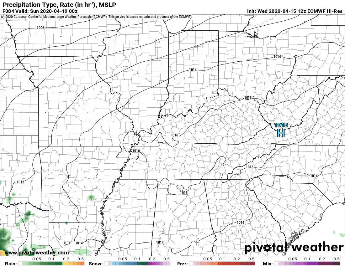
Sunday Forecast: Mostly cloudy. A chance of showers.
What is the chance of precipitation?MO ~ 40% IL ~ 40% KY ~ 40% TN ~ 40%
Temperature range: MO Bootheel 66° to 68° SE MO 63° to 66° South IL 63° to 66° Northwest KY (near Indiana border) 63° to 66° West KY 64° to 68° NW TN 66° to 68°
Wind direction and speed: Southwest to west wind at 6 to 12 mph
Wind chill or heat index (feels like) temperature forecast: 63° to 66°
Coverage of precipitation: Scattered
What impacts are anticipated from the weather? Wet roadways.
Should I cancel my outdoor plans? No, but check the weather radars.
UV Index: 6. High.
Sunrise: 6:14 AM
Sunset: 7:34 PM
.
Sunday night Forecast: Cloudy before midnight. Any remaining showers will come to an end. Clearing northwest to southeast.
What is the chance of precipitation? MO ~ 30% IL ~ 30% KY ~ 40% TN ~ 40%
Temperature range: MO Bootheel 44° to 46° SE MO 40° to 45° South IL 40° to 45° Northwest KY (near Indiana border) 43° to 46° West KY 43° to 46° NW TN 43° to 46°
Wind direction and speed: West and northwest wind at 5 to 10 mph
Wind chill or heat index (feels like) temperature forecast: 42° to 46°
Coverage of precipitation: Ending
What impacts are anticipated from the weather? Wet roadways early. Rain ending early in the night.
Should I cancel my outdoor plans? No, but check the weather radars.
Moonrise: 5:00 AM
Moonset: 4:32 PM
The phase of the moon: Waning crescent.
.
April 20, 2020
How confident am I that this days forecast will verify? High confidence
Monday Forecast: Mostly sunny. A few clouds.
What is the chance of precipitation? MO ~ 0% IL ~ 0% KY ~ 0% TN ~ 0%
Temperature range: MO Bootheel 65° to 70° SE MO 64° to 68° South IL 64° to 68° Northwest KY (near Indiana border) 64° to 68° West KY 64° to 68° NW TN 64° to 68°
Wind direction and speed: North and northwest at 6 to 12 mph
Wind chill or heat index (feels like) temperature forecast: 64° to 68°
Coverage of precipitation: None
What impacts are anticipated from the weather? None
Should I cancel my outdoor plans? No
UV Index: 8. Very high
Sunrise: 6:13 AM
Sunset: 7:35 PM
.
Monday night Forecast: Mostly clear. A few clouds from time to time.
What is the chance of precipitation? MO ~ 0% IL ~ 0% KY ~ 0% TN ~ 0%
Temperature range: MO Bootheel 45° to 50° SE MO 44° to 48° South IL 44° to 48° Northwest KY (near Indiana border) 44° to 48° West KY 44° to 48° NW TN 46° to 50°
Wind direction and speed: Southwest at 5 to 10 mph
Wind chill or heat index (feels like) temperature forecast: 44° to 48°
Coverage of precipitation: None
What impacts are anticipated from the weather? None
Should I cancel my outdoor plans? No
Moonrise: 5:26 AM
Moonset: 5:27 PM
The phase of the moon: Waning Crescent
.
April 21, 2020
How confident am I that this days forecast will verify? Medium confidence
Tuesday Forecast: Mostly sunny. Warmer.
What is the chance of precipitation? MO ~ 0% IL ~ 0% KY ~ 0% TN ~ 0%
Temperature range: MO Bootheel 70° to 74° SE MO 68° to 74° South IL 68° to 72° Northwest KY (near Indiana border) 68° to 70° West KY 68° to 74° NW TN 72° to 75°
Wind direction and speed: South and southwest wind at 7 to 14 mph. Gusty PM.
Wind chill or heat index (feels like) temperature forecast: 64° to 70°
Coverage of precipitation: None
What impacts are anticipated from the weather? None
Should I cancel my outdoor plans? No
UV Index: 8. Very high
Sunrise: 6:12 AM
Sunset: 7:36 PM
.
Tuesday night Forecast: Increasing clouds. A chance of scattered showers and thunderstorms late. Mainly over southeast Missouri and southern Illinois.
What is the chance of precipitation? MO ~ 30% IL ~ 30% KY ~ 20% TN ~ 20%
Temperature range: MO Bootheel 53° to 56° SE MO 52° to 55° South IL 52° to 55° Northwest KY (near Indiana border) 52° to 55° West KY 52° to 55° NW TN 54° to 58°
Wind direction and speed: South and southwest at 7 to 14 mph
Wind chill or heat index (feels like) temperature forecast: 54° to 58°
Coverage of precipitation: Scattered. Developing from west to east.
What impacts are anticipated from the weather? Wet roadways. Perhaps lightning.
Should I cancel my outdoor plans? No
Moonrise: 5:51 AM
Moonset: 6:24 PM
The phase of the moon: Waning Crescent
.
April 22, 2020
How confident am I that this days forecast will verify? Medium confidence
Wednesday Forecast: Cloudy. Showers and thunderstorms likely.
What is the chance of precipitation? MO ~ 60% IL ~ 60% KY ~ 60% TN ~ 60%
Temperature range: MO Bootheel 66° to 70° SE MO 64° to 68° South IL 64° to 68° Northwest KY (near Indiana border) 64° to 68° West KY 64° to 68° NW TN 64° to 68°
Wind direction and speed: South and southwest wind at 10 to 20 mph.
Wind chill or heat index (feels like) temperature forecast: 64° to 70°
Coverage of precipitation: Perhaps numerous
What impacts are anticipated from the weather? Wet roadways. Lightning.
Should I cancel my outdoor plans? Have a plan B and monitor updates.
UV Index: 6. High
Sunrise: 6:10 AM
Sunset: 7:37 PM
.
Wednesday night Forecast: Cloudy with scattered showers and thunderstorms.
What is the chance of precipitation? MO ~ 40% IL ~ 40% KY ~ 40% TN ~ 40%
Temperature range: MO Bootheel 53° to 56° SE MO 52° to 55° South IL 52° to 55° Northwest KY (near Indiana border) 52° to 55° West KY 52° to 55° NW TN 54° to 58°
Wind direction and speed: Southwest to west at 6 to 12 mph
Wind chill or heat index (feels like) temperature forecast: 52° to 55°
Coverage of precipitation: Scattered
What impacts are anticipated from the weather? Wet roadways. Perhaps lightning.
Should I cancel my outdoor plans? Monitor updates
Moonrise: 6:17 AM
Moonset: 7:20 PM
The phase of the moon: New
.

.
- Patchy frost Thursday morning.
- Scattered wet fields.
- Dry areas have developed over portions of the region.
- Rain chances Friday.
.
Click to enlarge the graphics.
Click graphics to enlarge them.
.
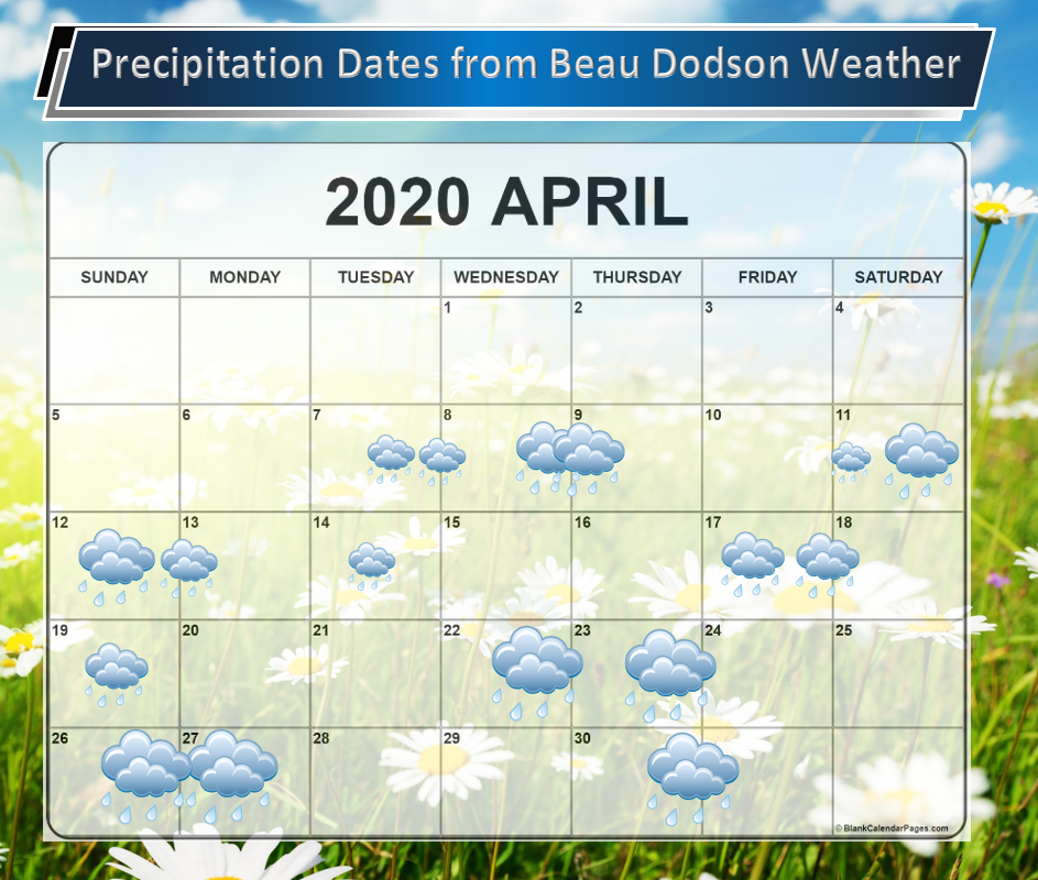
These are dates that may have precipitation. Monitor the trends in the forecast.
Anything past day seven is low confidence.
![]()
![]()
Graphic-cast
Click here if you would like to return to the top of the page.
Illinois
During active weather check my handwritten forecast towards the top of the page.

.
Kentucky
During active weather check my handwritten forecast towards the top of the page.


.
Tennessee
During active weather check my handwritten forecast towards the top of the page.

.
Today through April 20th. Most likely none. I will monitor Friday for lightning.
Today’s outlook (below).
Light green is where thunderstorms may occur but should be below severe levels.
Dark green is a level one risk. Yellow is a level two risk. Orange is a level three (enhanced) risk. Red is a level four (moderate) risk. Pink is a level five (high) risk.
One is the lowest risk. Five is the highest risk.
A severe storm is one that produces 58 mph wind or higher, quarter size hail, and/or a tornado.

The black outline is our local area.

.
Tomorrow’s severe weather outlook.

.

.
The images below are from the WPC. Their totals are a bit lower than our current forecast. I wanted to show you the comparison.
24-hour precipitation outlook.
.
 .
.
48-hour precipitation outlook.
.
.
72-hour precipitation outlook.
.
![]()

![]()
..
Weather advice:
Monitor updates concerning the chance of severe weather on Thursday afternoon and night. Download the Beau Dodson Weather Talk app from the app store. Search for Weather Talk by the Fire Horn. Download it. Install it. It is for subscribers. Not a subscriber? Go to www.weathertalk.com/welcome
.
Weather Discussion
-
- Cool this morning.
- A chance of rain late Thursday night and Friday.
- Monitoring rain chances next week. Thunderstorms, as well.
We had frost and freeze conditions again this morning. The freezing temperatures were mainly confined to southwest Illinois and northwest Kentucky. Frost, elsewhere.
The weather will be calm today. No issues.
Clouds increase from northwest to southeast tonight. These clouds will thicken as we move past midnight.
Scattered showers will develop late tonight over the northern portions of southeast Missouri and northern portions of southern Illinois.
These rain showers will push southward Friday. A few lightning bolts are possible, as well. No severe weather.
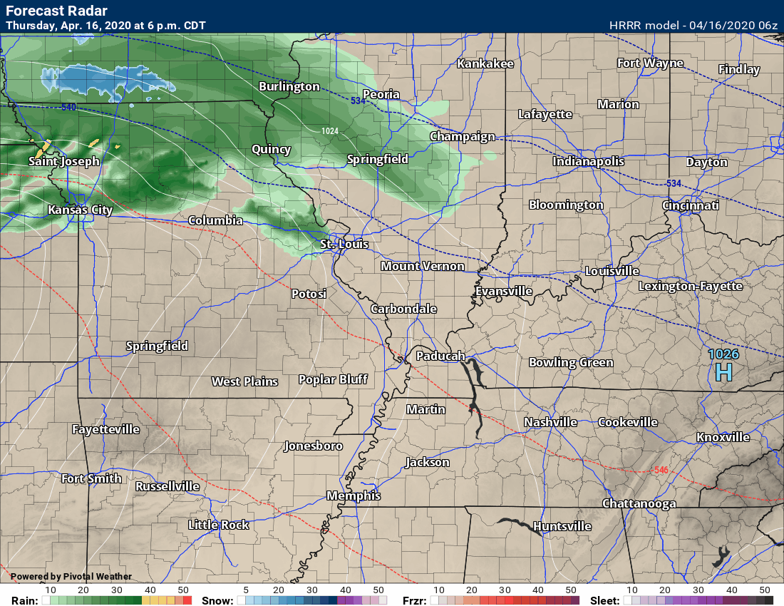
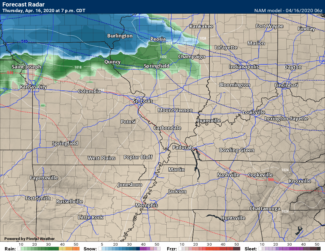
Here is the Hrrr model guidance. Future-cast radar. Click it to enlarge it.
It will once again turn colder Friday night. If the clouds clear then frost will likely develop. Lows will be in the middle 30s. Lows could dip into the lower 30s if clouds do clear.
Saturday will be dry.
Clouds thicken again Saturday night and Sunday. A weak system will push across the region. This will help with the formation of scattered rain showers. Not a heavy rain. No severe weather.
We dry out again Sunday night and Monday.
Our next system will take shape Tuesday night and Wednesday. Widespread rain is forecast to develop over the area. Thunderstorms will be possible. A bit soon to know if severe weather is a concern. Monitor updates.
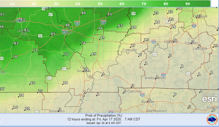
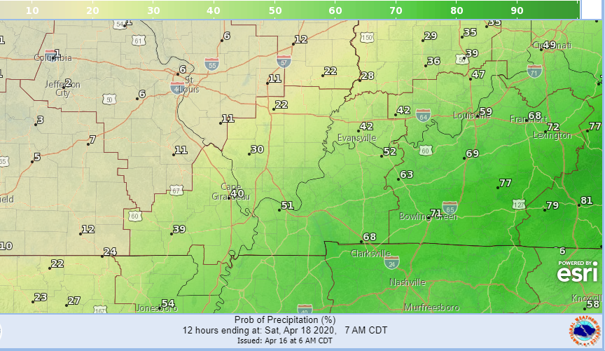
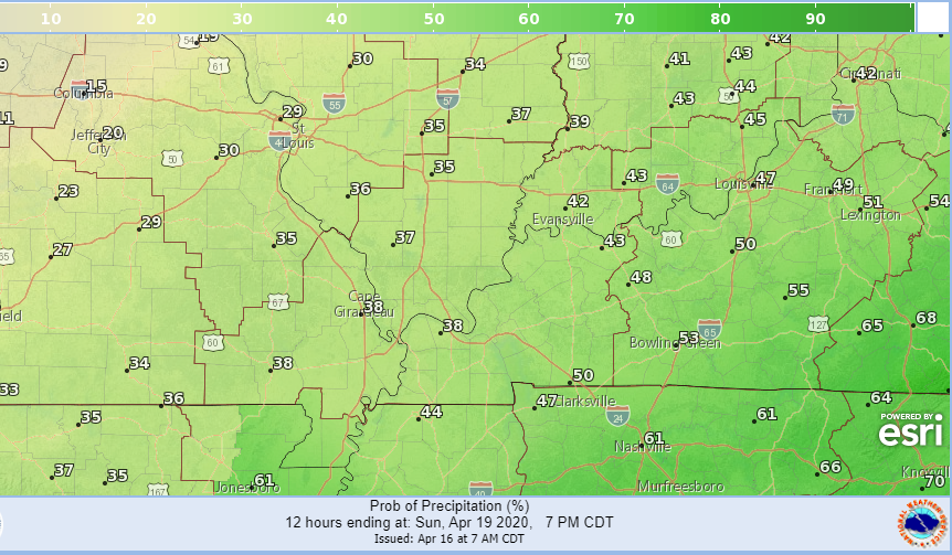
Let’s take a look at rain probabilities (%).
This shows you the rain chances tonight (mainly between 10 PM and 7 AM).
Rain advances from the NW towards the SE.
This shows you Friday’s rain chances. During the day. It will end northwest to southeast late in the day.
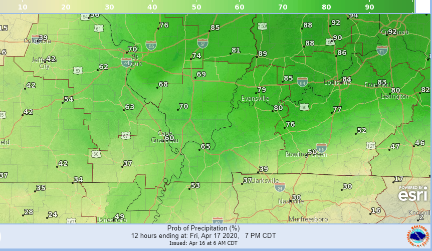
This shows you the Friday evening rain chances. Again, ending northwest to southeast.
Some clearing after the rain exits. If the clearing does occur then frost will be possible.
Rain chances increase Saturday night into Sunday. Scattered showers.
.![]()
.
 .
.
Click here if you would like to return to the top of the page.
Again, as a reminder, these are models. They are never 100% accurate. Take the general idea from them.
What should I take from these?
- The general idea and not specifics. Models usually do well with the generalities.
- The time-stamp is located in the upper left corner.
.
What am I looking at?
You are looking at different models. Meteorologists use many different models to forecast the weather. All models are wrong. Some are more wrong than others. Meteorologists have to make a forecast based on the guidance/models.
I show you these so you can see what the different models are showing as far as precipitation. If most of the models agree, then the confidence in the final weather forecast increases.
.
This animation is the Hrrr model.
This animation shows you what radar might look like as the next system pulls through the region. It is a future-cast radar.
Green is rain. Blue is snow. Pink and red represent sleet and freezing rain.
Time-stamp upper left. Click the animation to enlarge it.
This is the Thursday night (late) and Friday system
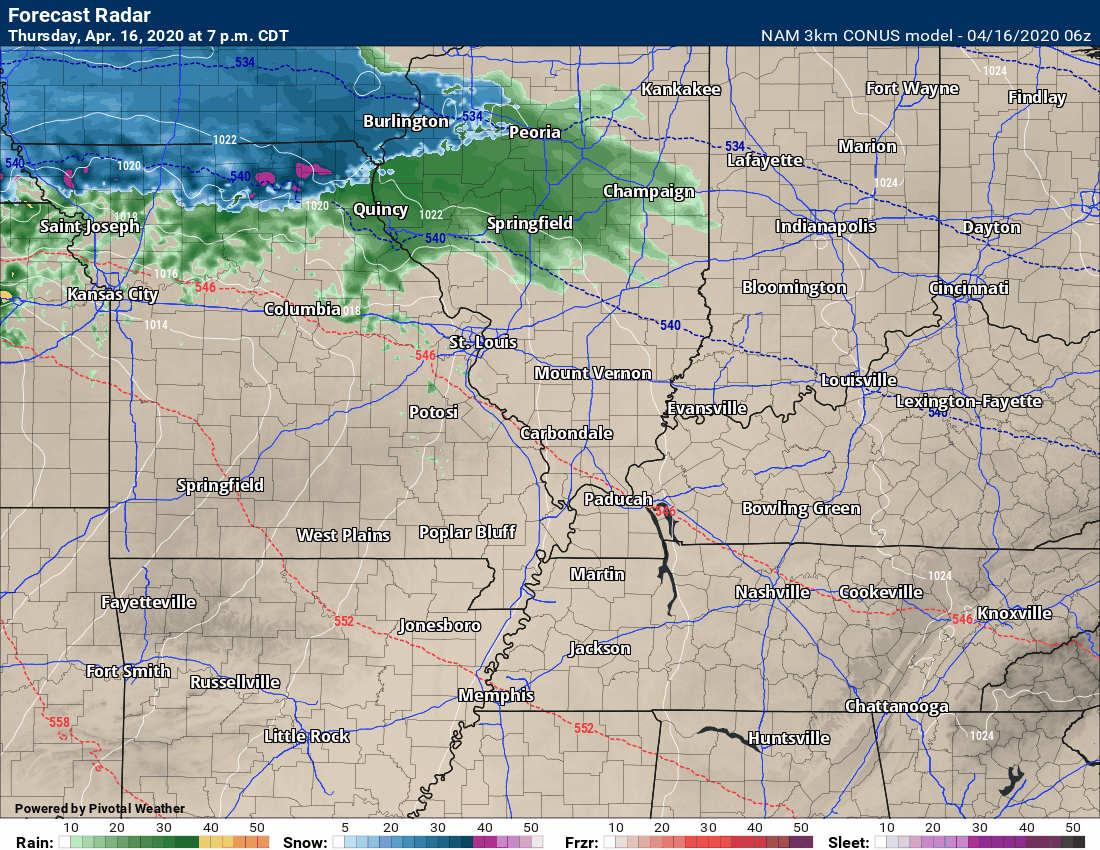
This animation is the 3K American Model.
This animation shows you what radar might look like as the next system pulls through the region. It is a future-cast radar.
Green is rain. Blue is snow. Pink and red represent sleet and freezing rain.
Time-stamp upper left. Click the animation to enlarge it.
This is the Thursday night (late) and Friday system
.
This next animation is the NAM American Model.
This animation shows you what radar might look like as the system pulls through the region. It is a future-cast radar.
Green is rain. Blue is snow. Pink and red represent sleet and freezing rain.
Time-stamp upper left. Click the animation to enlarge it.
This is the Thursday night (late) and Friday system. Then, the late Saturday night/Sunday system.
.
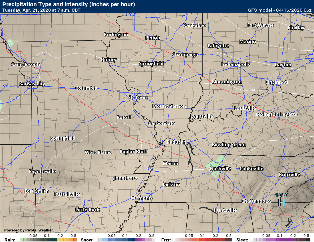
This next animation is the GFS American Model.
This animation shows you what radar might look like as the system pulls through the region. It is a future-cast radar.
Green is rain. Blue is snow. Pink and red represent sleet and freezing rain.
Time-stamp upper left. Click the animation to enlarge it.
This is the Thursday night (late) and Friday system. Then, it shows you the Sunday system.
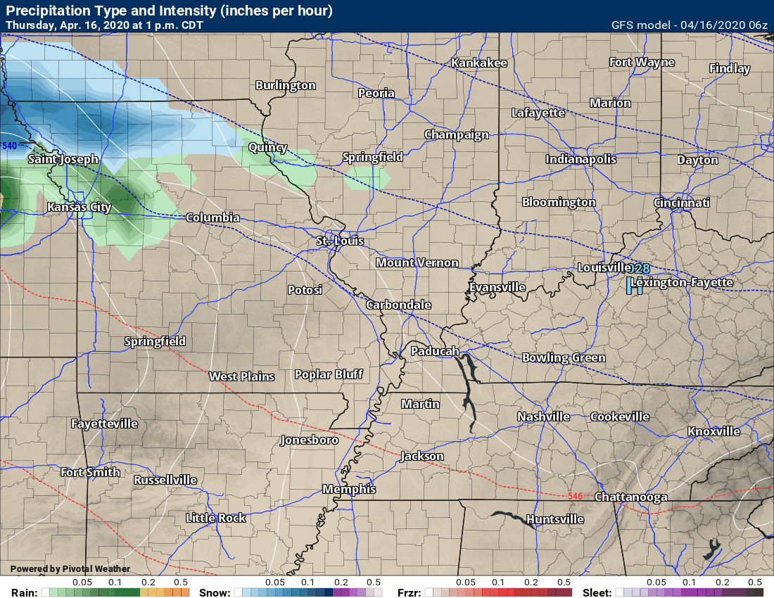
This is the system next Tuesday night into Wednesday system.
.
This animation is the EC model.
This animation shows you what radar might look like as the next system pulls through the region. It is a future-cast radar.
Green is rain. Blue is snow. Pink and red represent sleet and freezing rain.
Time-stamp upper left. Click the animation to enlarge it.
This is the Thursday night and Friday system.
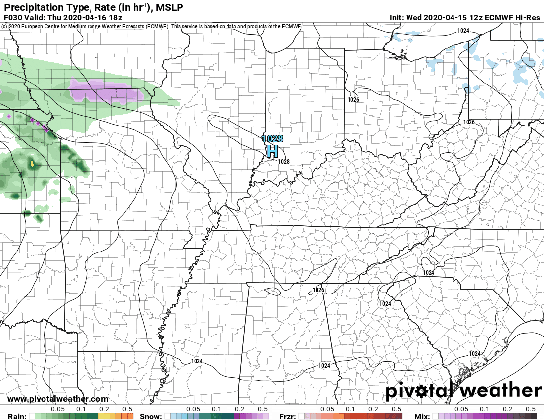
This is the Sunday through Wednesday events.
.
![]()
.

.
Click here if you would like to return to the top of the page.
.
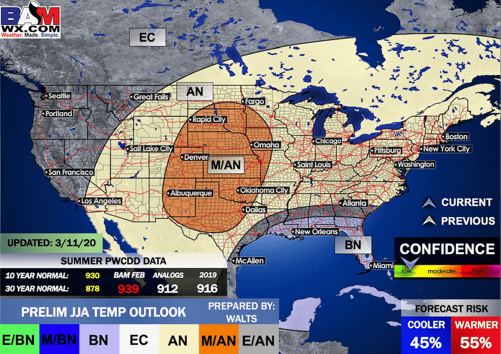
Average high temperatures for this time of the year are around 68 degrees.
Average low temperatures for this time of the year are around 44 degrees.
Average precipitation during this time period ranges from 0.90″ to 1.40″
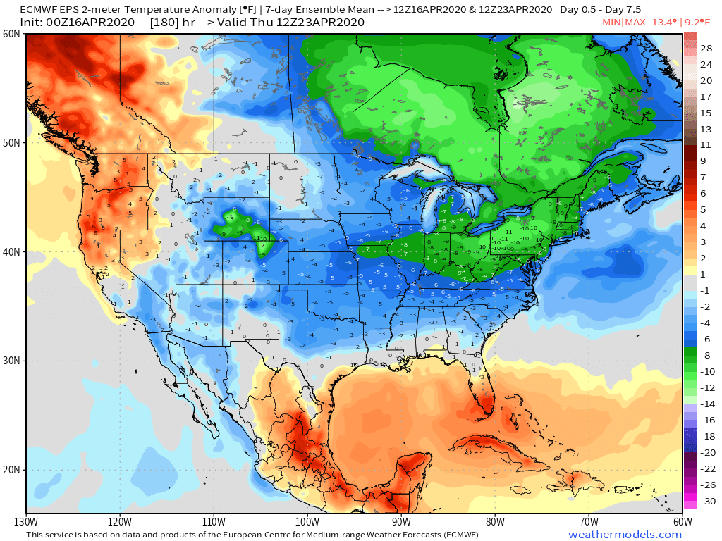
Yellow and orange colors are above average temperatures. Red is much above average. Light blue and blue are below-average temperatures. Green to purple colors represents much below-average temperatures.
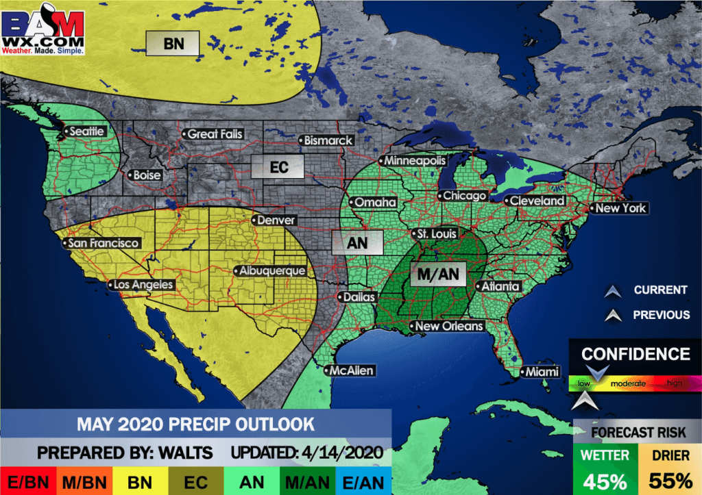
This outlook covers April 16th through April 22nd
Click on the image to expand it.
.
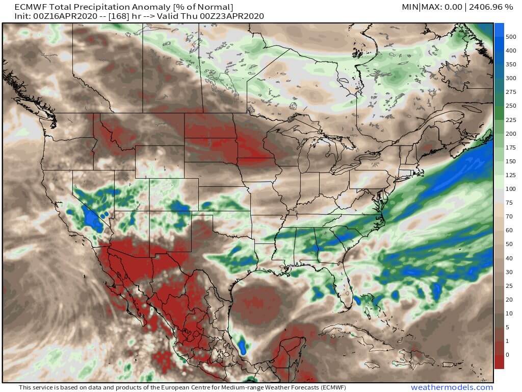
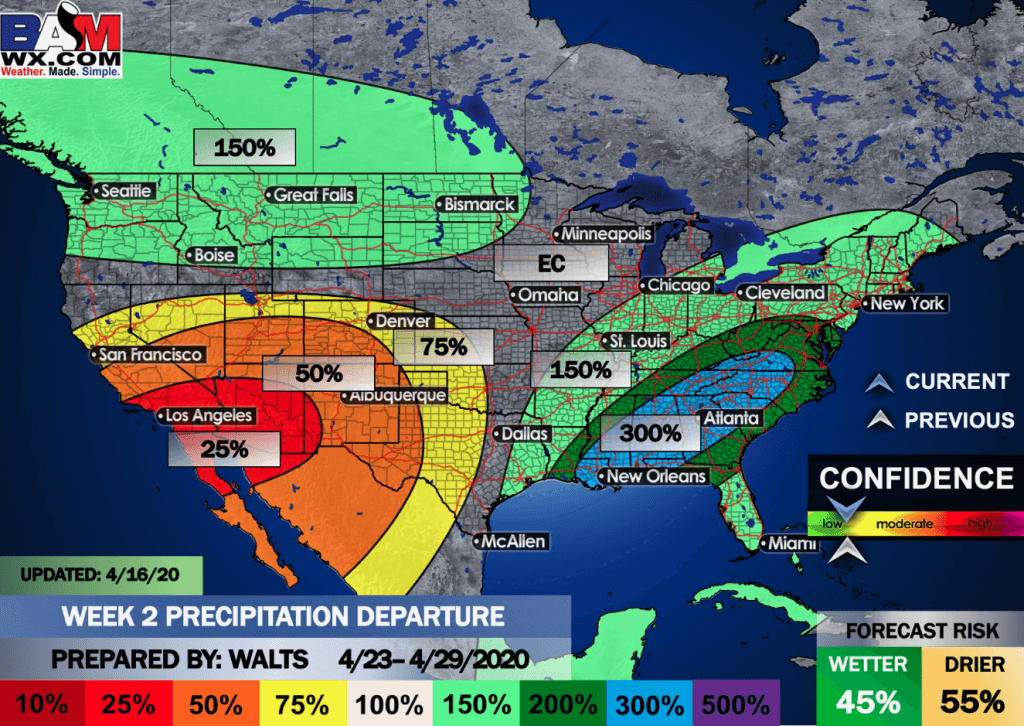
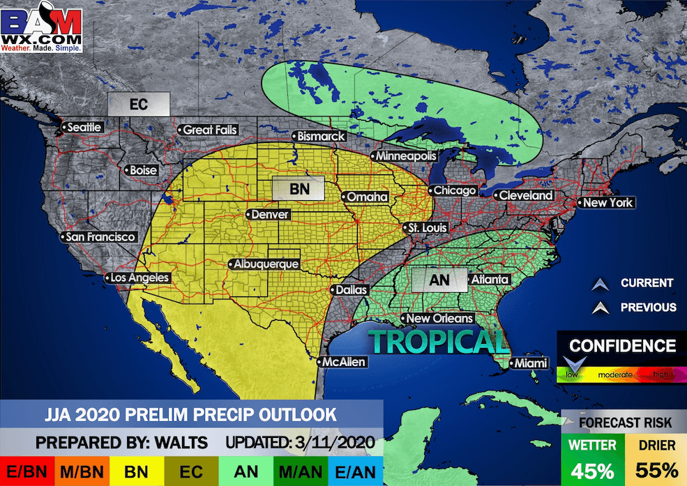
The precipitation forecast is PERCENT OF AVERAGE. Brown is below average. Green is above average. Blue is much above average.
.

Average low temperatures for this time of the year are around 47 degrees
Average precipitation during this time period ranges from 0.90″ to 1.40″
.
This outlook covers April 23rd through April 29th
Click on the image to expand it.
.
The precipitation forecast is PERCENT OF AVERAGE. For example, if your average rainfall is 1.00″ and the graphic shows 25%, then that would mean 0.25″ of rain is anticipated.
.
.

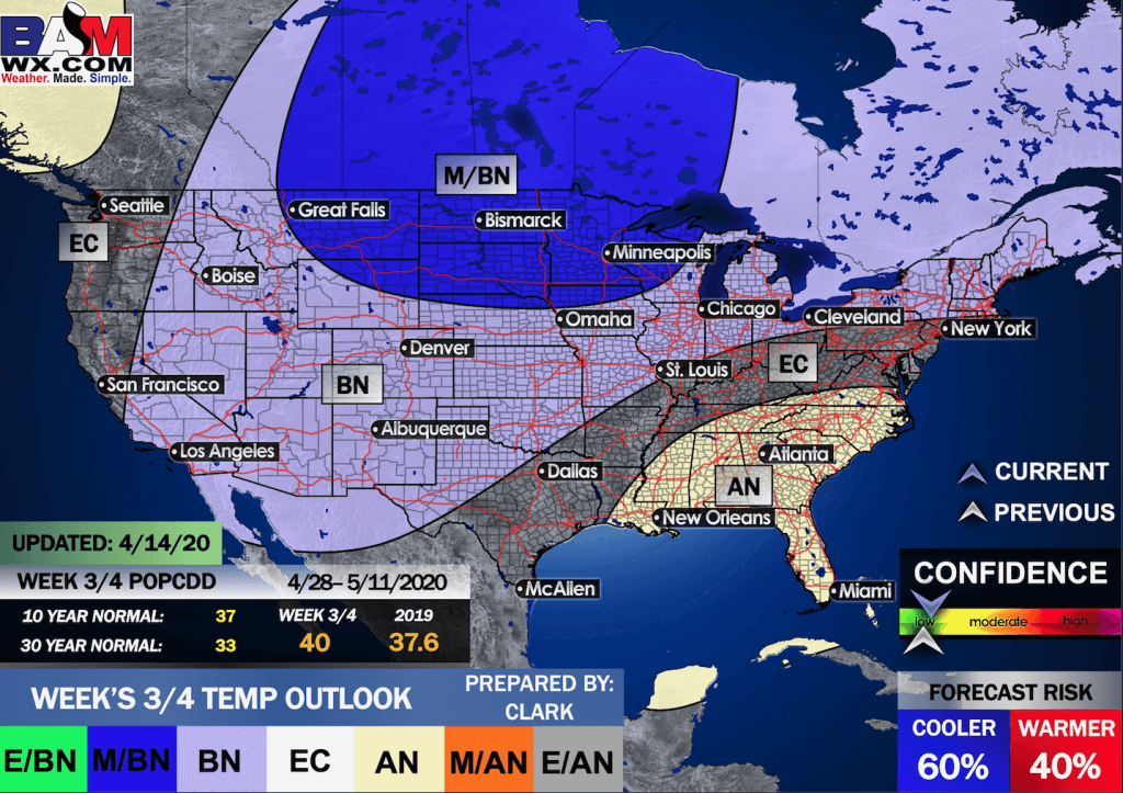
EC = Equal chances of above or below average
BN= Below average
M/BN = Much below average
AN = Above average
M/AN = Much above average
E/AN = Extremely above average
Average low temperatures for this time of the year are around 52 degrees
Average precipitation during this time period ranges from 1.80″ to 2.40″
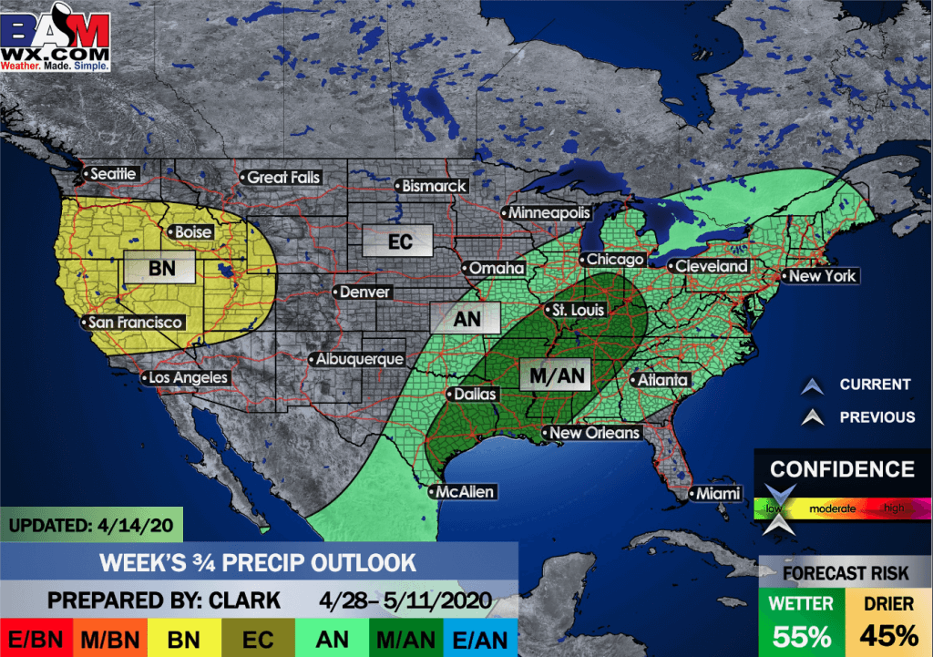
This outlook covers April 28th through May 11th
.
.
Precipitation outlook
 1
1
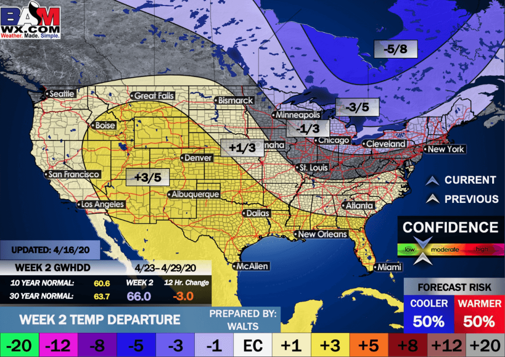
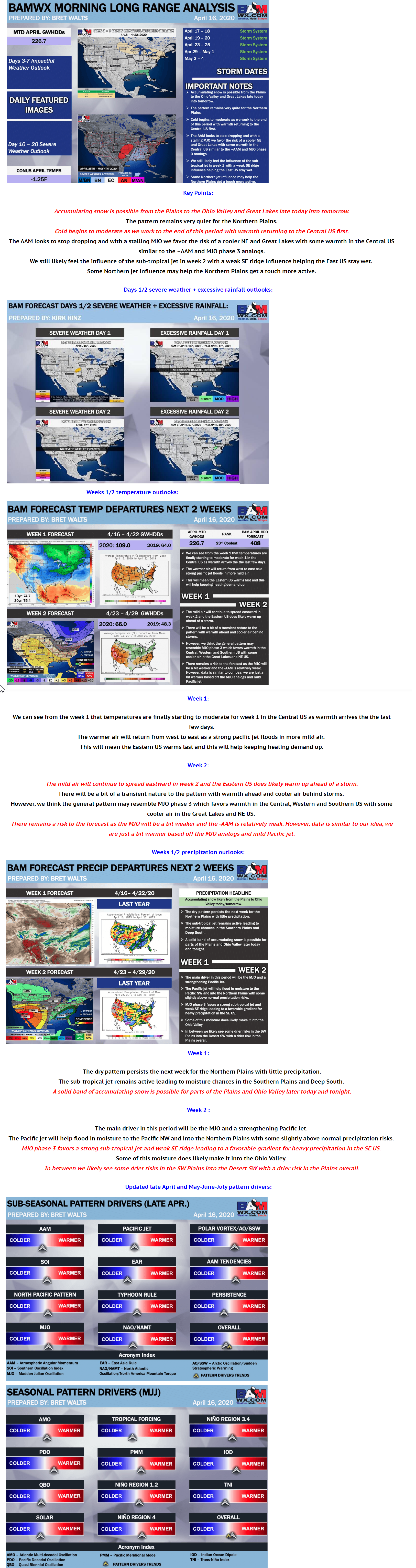
LONG RANGE DISCUSSION
Key Points: This was written by the BAMwx team. I don’t edit it.
Click to enlarge all of the images below
These graphics are updated Monday through Friday between 8:30 AM and 9:30 AM.
NOTE: These may not be updated on Saturday and Sunday.
Click the image below to enlarge it.
.
.
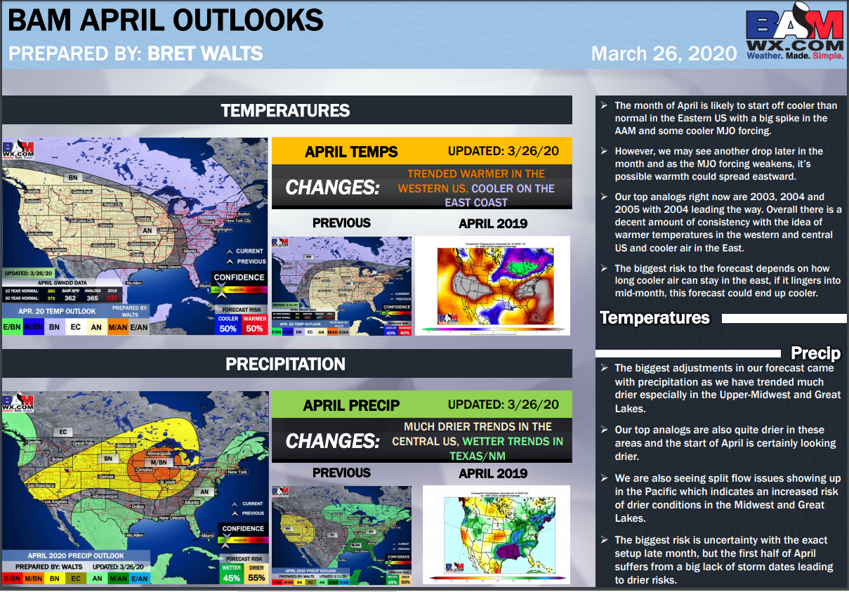
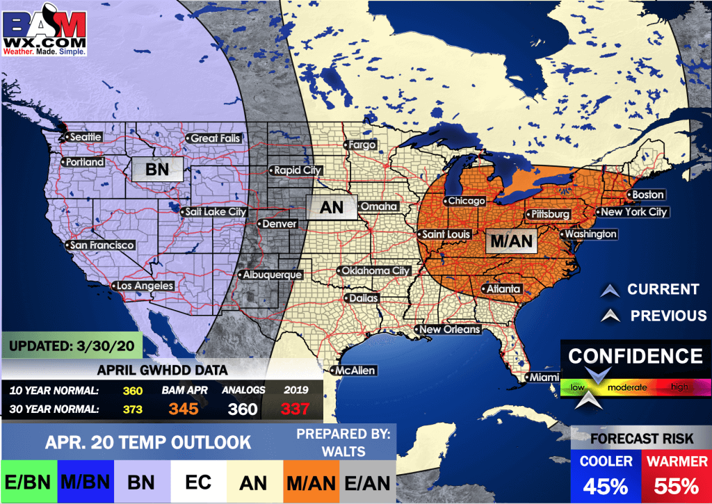
April temperature departures forecast
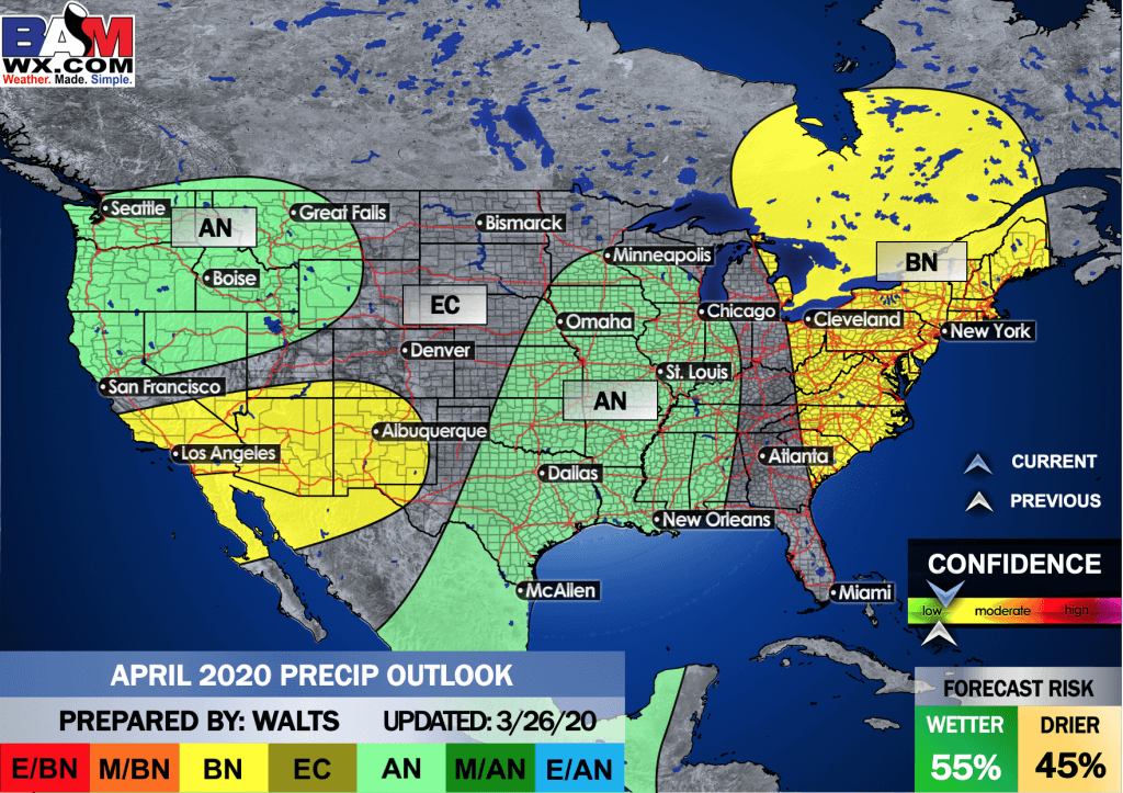
April precipitation departures
.
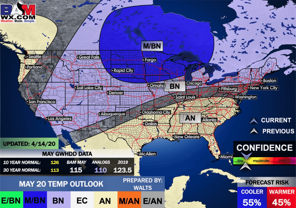
May temperature departures
Click on the images to enlarge them
May precipitation departures
.
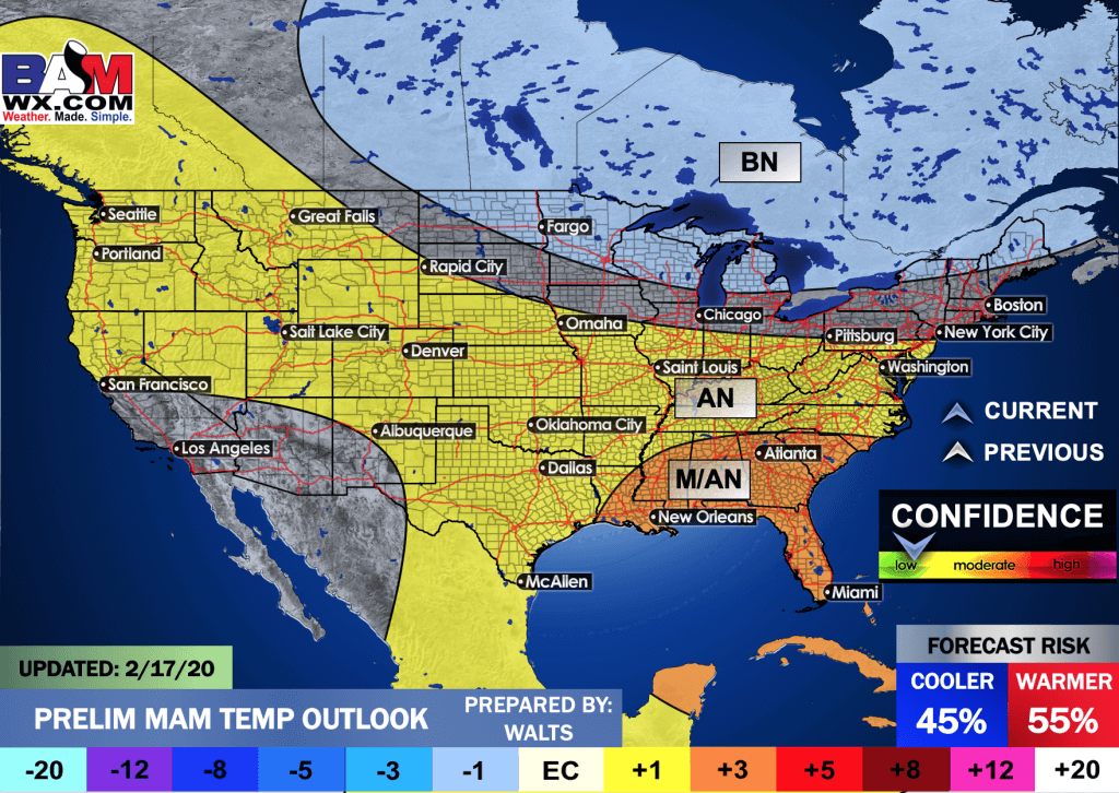
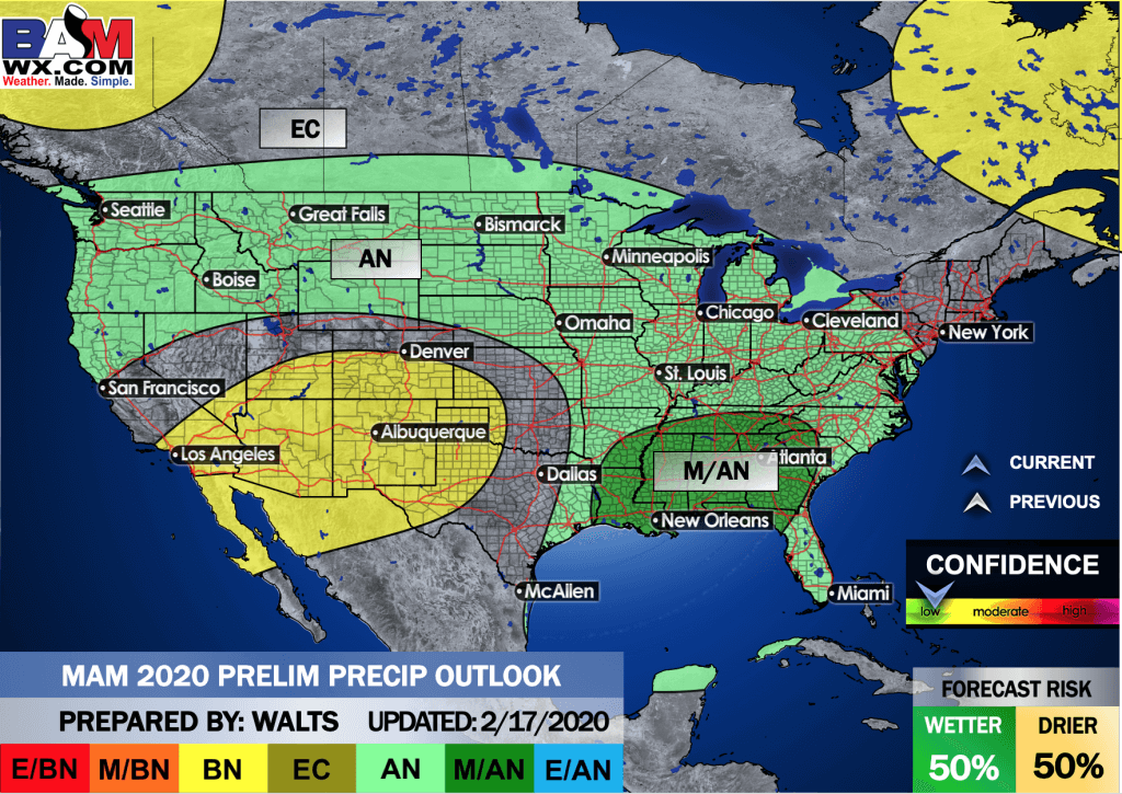
March through May
.
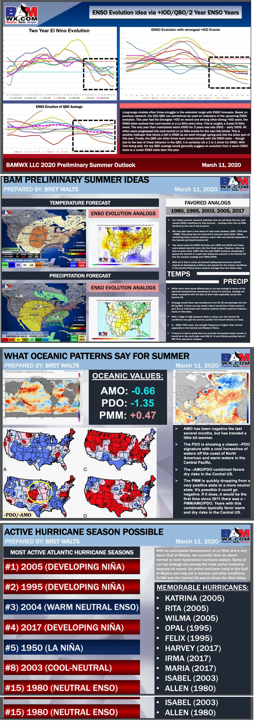
Preliminary Summer Forecast
.
June through August preliminary temperature outlook
June through August preliminary precipitation outlook
.
![]()

Great news! The videos are now found in your Weathertalk app and on the WeatherTalk website.
These are bonus videos for subscribers.
The app is for subscribers. Subscribe at www.weathertalk.com/welcome then go to your app store and search for WeatherTalk
Subscribers, PLEASE USE THE APP. ATT and Verizon are not reliable during severe weather. They are delaying text messages.
The app is under WeatherTalk in the app store.

Apple users click here

Android users click here
.

Radar Link: Interactive local city-view radars & regional radars.
You will find clickable warning and advisory buttons on the local city-view radars.
If the radar is not updating then try another one. If a radar does not appear to be refreshing then hit Ctrl F5. You may also try restarting your browser.
Not working? Email me at beaudodson@usawx.com
National map of weather watches and warnings. Click here.
Storm Prediction Center. Click here.
Weather Prediction Center. Click here.
.

Live lightning data: Click here.
.

Interactive GOES R satellite. Track clouds. Click here.
GOES 16 slider tool. Click here.
College of Dupage satellites. Click here
.

Here are the latest local river stage forecast numbers Click Here.
Here are the latest lake stage forecast numbers for Kentucky Lake and Lake Barkley Click Here.
.
.
Find Beau on Facebook! Click the banner.

.
Find Beau on Twitter! Share your weather photos! @beaudodson

 .
.Click here if you would like to return to the top of the page.
Did you know that a portion of your monthly subscription helps support local charity projects? Not a subscriber? Becoming one at www.weathertalk.com
You can learn more about those projects by visiting the Shadow Angel Foundation website and the Beau Dodson News website.
