
.

🌪️ Seven-Day Tornado Outlook ⛈️
April 1st to April 7th
Current risk: MONITOR UPDATES
Current confidence level: MEDIUM.
Comments: At this time, the tornado threat appears low. I am monitoring Thursday afternoon and evening. A few storms could be intense and perhaps even severe. The tornado risk isn’t zero, but it is low. Monitor updates.
.

Seven-Day Hazardous Weather Outlook
1. Is lightning in the forecast? YES. Scattered lightning is possible over portions of the region today. A chance area-wide Thursday through Saturday night.
2. Are organized severe thunderstorms. POSSIBLE. A few of the thunderstorms on Thursday afternoon and night could become severe with gusty winds and hail. The tornado risk is low, but not zero. I am also monitoring Saturday as another cold front pushes across the region. Monitor updated forecasts.
..3. Is significant or widespread flash flooding in the forecast? NO. A series of cold fronts will bring a chance of rain this week. Locally heavy totals are possible, but widespread or significant flash flooding is unlikely. Perhaps some small local issues on roads and ditches that commonly have problems.
4. Will non-thunderstorm winds top 40 mph? POSSIBLE. On Thursday.
5. Will the temperature rise above 90 degrees? NO.
6. Is the heat index forecast to rise above 100 degrees? NO.
.
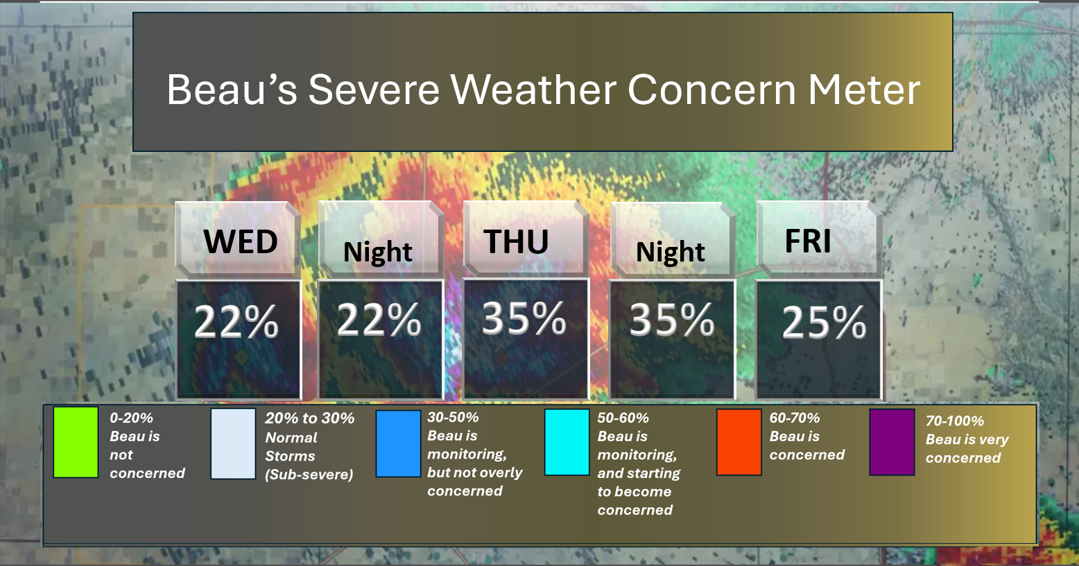
⛈️ Here is the short-range thunderstorm concern meter.
A few of the storms on Thursday afternoon and night could be severe with high wind gusts and hail. The tornado risk is low, but not zero.
.
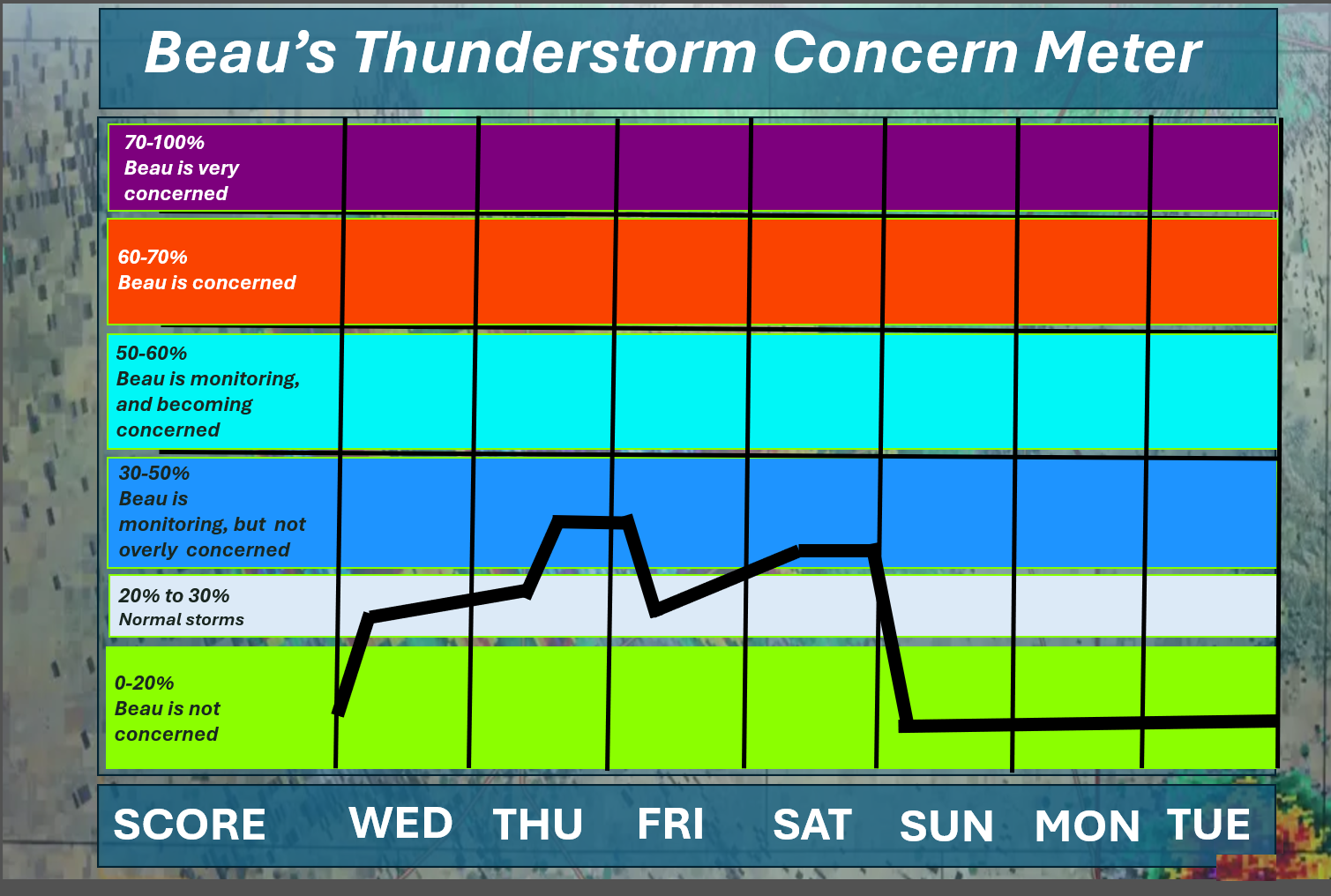
⛈️ Here is the extended thunderstorm concern meter.
Scattered lightning is possible from Wednesday into Saturday (on and off).
I will monitor Thursday and Saturday for a few stronger storms. I can’t rule out a few severe thunderstorms on Thursday afternoon and night. The primary concern would be gusty winds and hail. The tornado risk is low, but not zero.
.


.
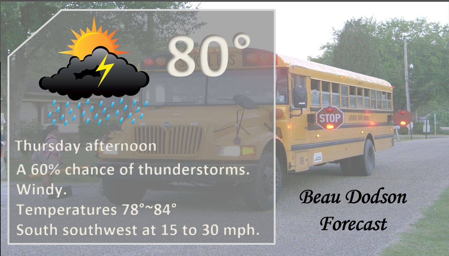
Here is your bus stop forecast
.
This morning
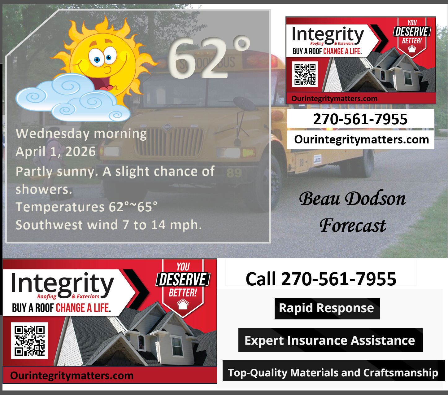
.
This afternoon
.
Tomorrow morning
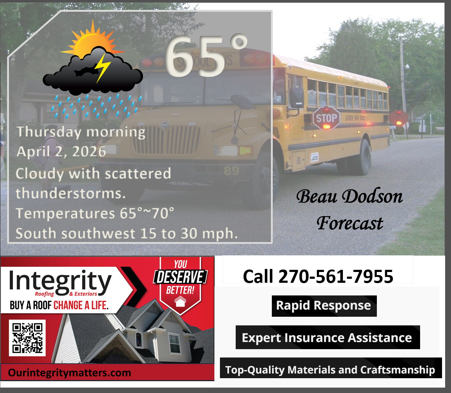
.
Tomorrow afternoon
.
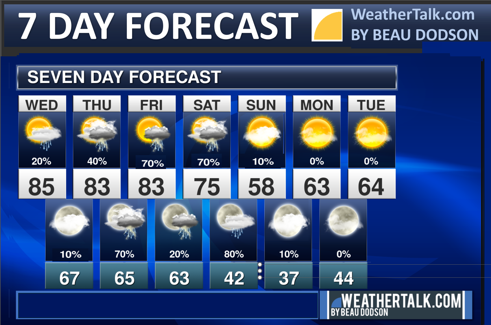
Seven-day outlook graphic.
See the video and graphics below for more details specific to your county. This is a broad-brush overview of the entire region.
.


Forecast discussion
- Warm through Friday with temperatures 10 to 20+ degrees above average.
- Several disturbances will bring a chance of showers and thunderstorms back to the area from today through Saturday night. See the video or graphics below where I break down the chances at your location.
- Peak chances will likely be Thursday through Saturday night.
- Easter Sunday is trending dry and cool.
- Patchy frost is possible on Monday morning.
- Rainfall totals of one to two inches are likely from Wednesday through Saturday. Locally higher totals are possible in thunderstorms. There is a trend for lower amounts from Owensboro to Hopkinsville eastward. Perhaps under one inch.
- A few of the thunderstorms could be intense or severe on Thursday afternoon and night. I am monitoring Saturday, as well.
.
 .
.
.
What is the primary weather concern today and tonight?
A few showers and thunderstorms are possible today (mainly over SE MO and southern IL). See the graphics below and/or the daily video.
.
Gusty winds are likely this week. Gusts may exceed 30 mph today. Gusty winds later this week, as well.
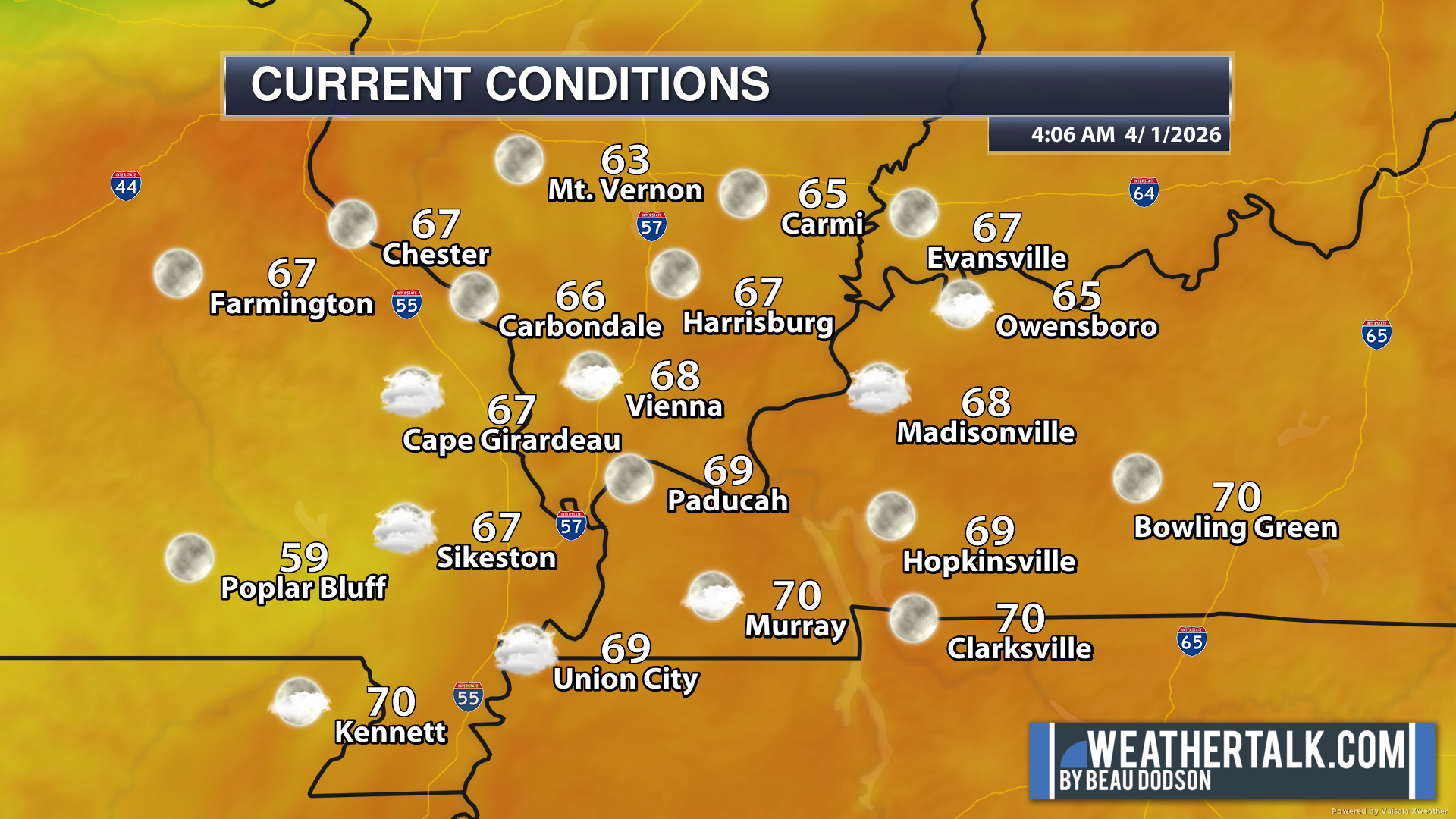
Here are the early morning current conditions.
A mild morning across the region. Some areas are already hitting the 70-degree mark.
.
Temperatures will be well above average over the coming days. It will turn cooler on Easter.
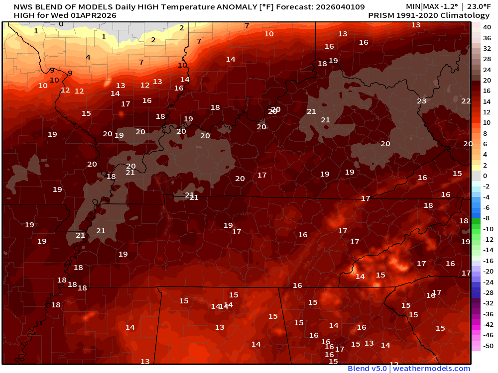
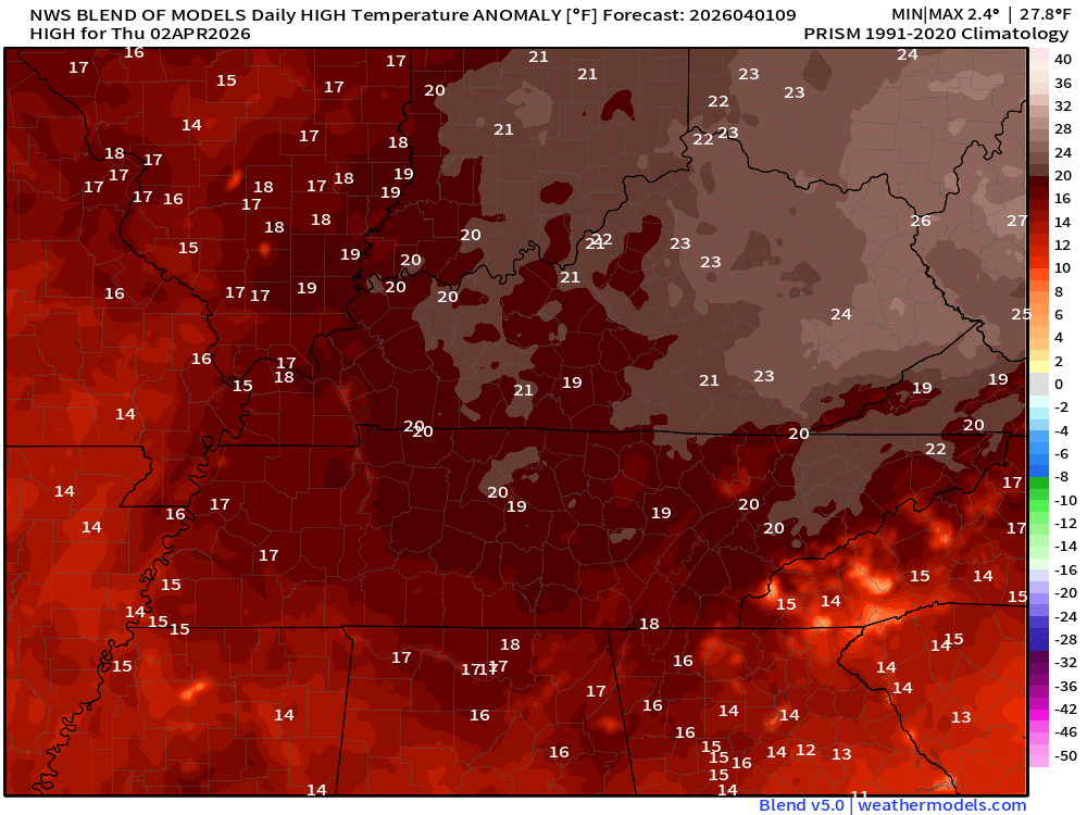
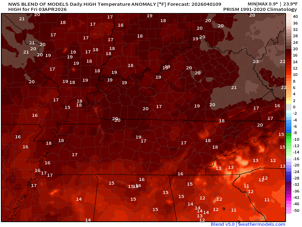
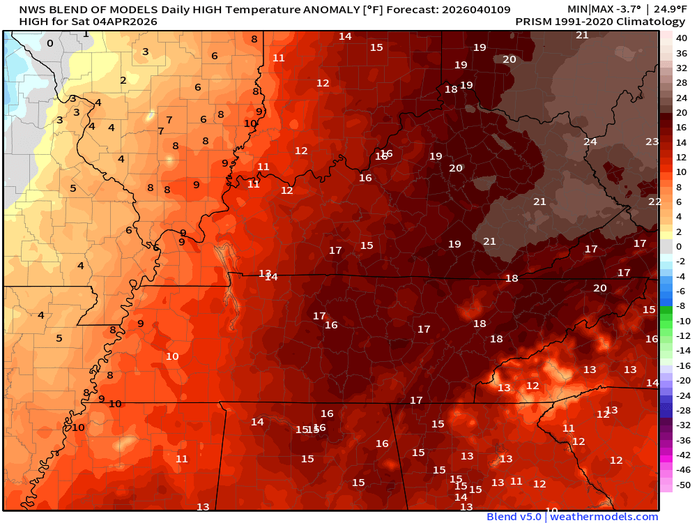
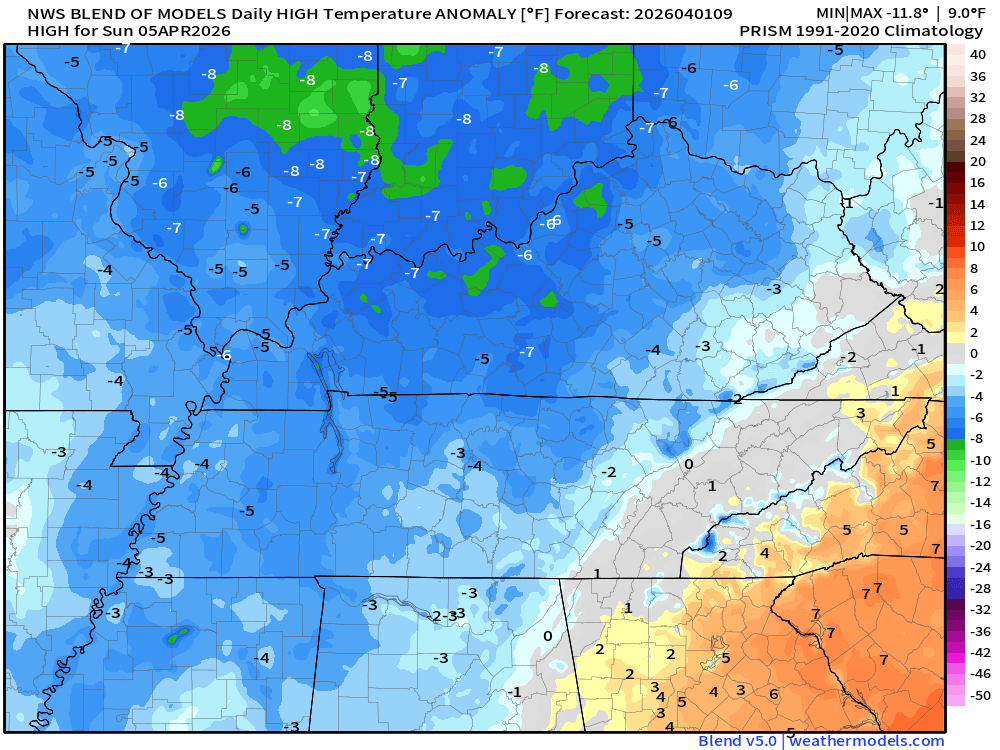
Let’s look at the temperature anomalies. How many degrees above average will temperatures be?
The normal high for April 1st is around 66 degrees.
The numbers represent how many degrees above average temperatures will be. Highs in the 50s on Sunday.
Double-click on the images to enlarge them.
Today’s anomalies
.
Thursday’s anomalies
.
Friday’s anomalies
.
Saturday’s anomalies
.
Sunday’s anomalies (below average by Sunday). The numbers represent how many degrees below average temperatures will be. Highs in the 50s on Sunday.
Normal lows are around 42 degrees.
.
Several cold and warm fronts will track across the region today through Saturday night.
Those systems should exit by Sunday morning. Easter Sunday will be cooler. It should be dry with showers ending before sunrise. The ground will be damp.
On-and-off showers and thunderstorms will result from this series of fronts. See the video and the graphics below for the rain chances for each 12-hour period.
How much rain is anticipated?
My forecast called for 1 to 2 inches of rain between tonight and Sunday morning.
There is some indication that my eastern counties may receive less than one inch. That would be Owensboro south to LBL and then eastward from there.
There is an 70% chance of 1 to 2 inches of rain from tonight through early Sunday morning.
There is a 20% chance of totals exceeding 2 inches.
We need the rain. Many areas are dry.
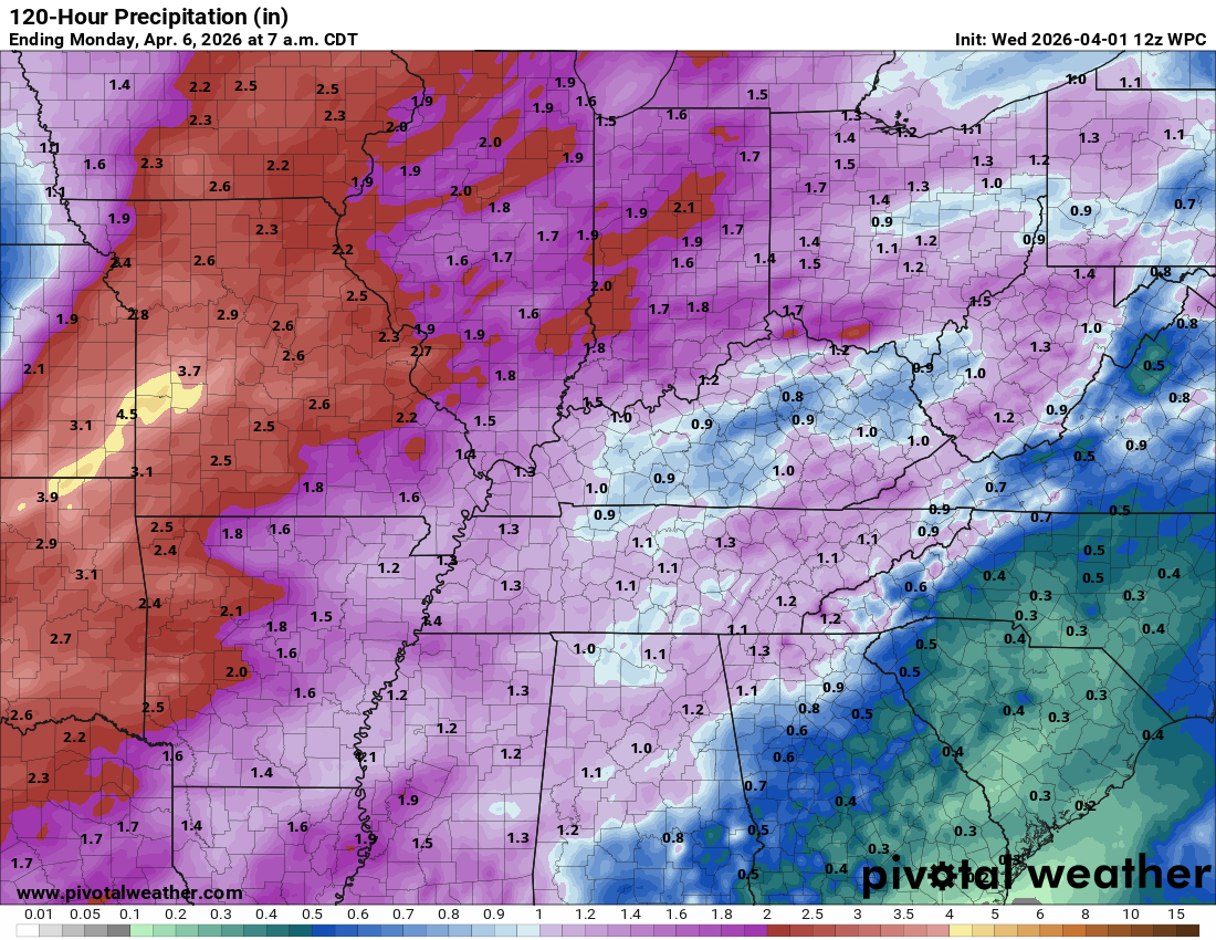
Here is the official NOAA/WPC rainfall forecast
Double-click the graphics to enlarge them. The NOAA/WPC forecast is a bit higher than the EC AI model.
Notice the area of lower totals over portions of Kentucky.
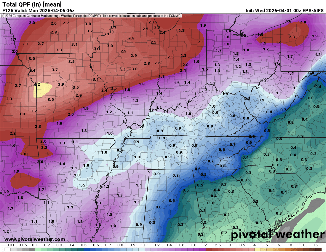
Here is the latest EC AI model rainfall totals.Double-click the graphics to enlarge them. The NOAA/WPC forecast is a bit higher than the EC AI model.Again, notice the lower area over portions of Kentucky and Tennessee. The bootheel, as well.
You get the general idea.
.
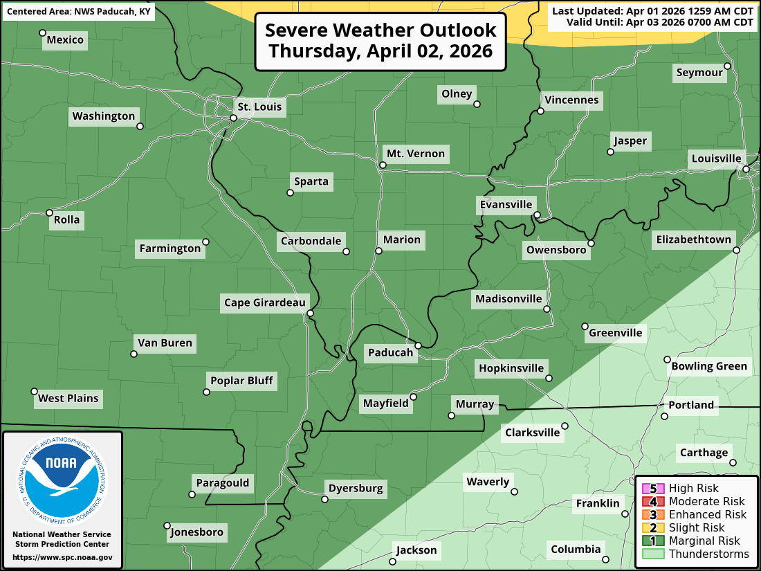
The severe weather threat has increased a bit for Thursday afternoon and night. The primary concern will be damaging wind and hail. A low tornado risk.
Here is that outlook from the SPC.
The dark green zone is a level one severe weather risk. The scale ranges from one to five. One being the lowest severe threat.
The light green zone is where storms are possible, but will likely remain below severe levels.
This is for Thursday afternoon and night.
Double-click the image to enlarge it.
.
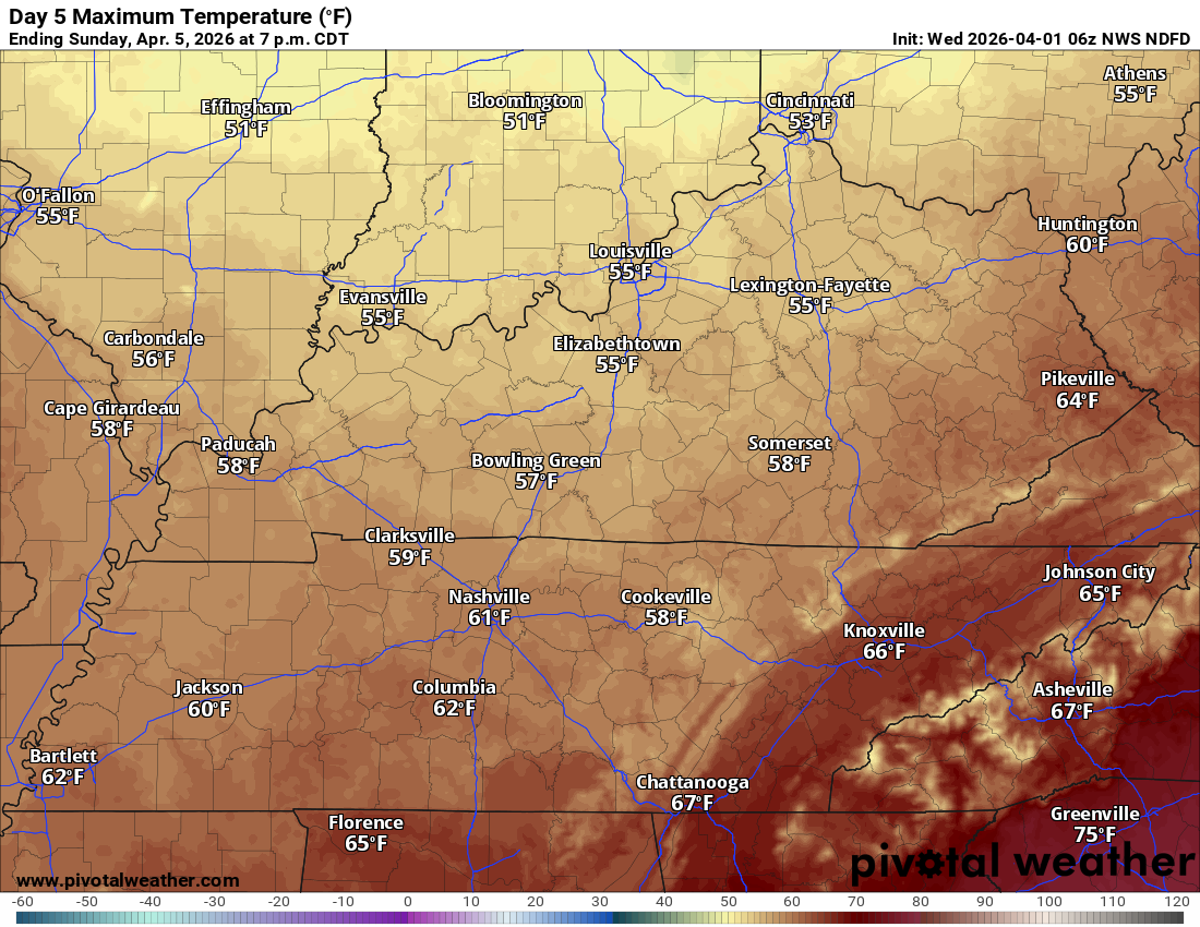
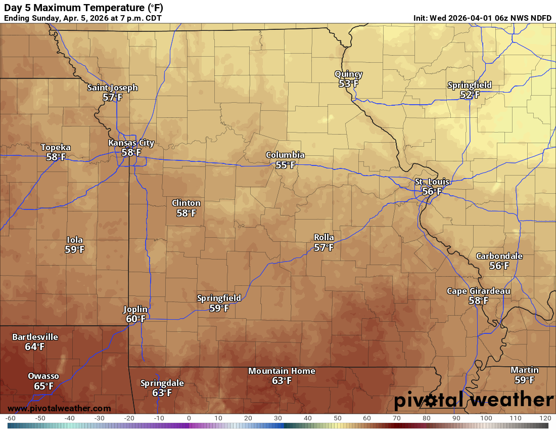
Easter Sunday should be dry (a slight chance of a shower before sunrise). It will be cooler. The ground will likely still be damp or wet from Saturday’s showers and thunderstorms.
Sunday’s high temperatures.
Double-click on the image to enlarge it.
.
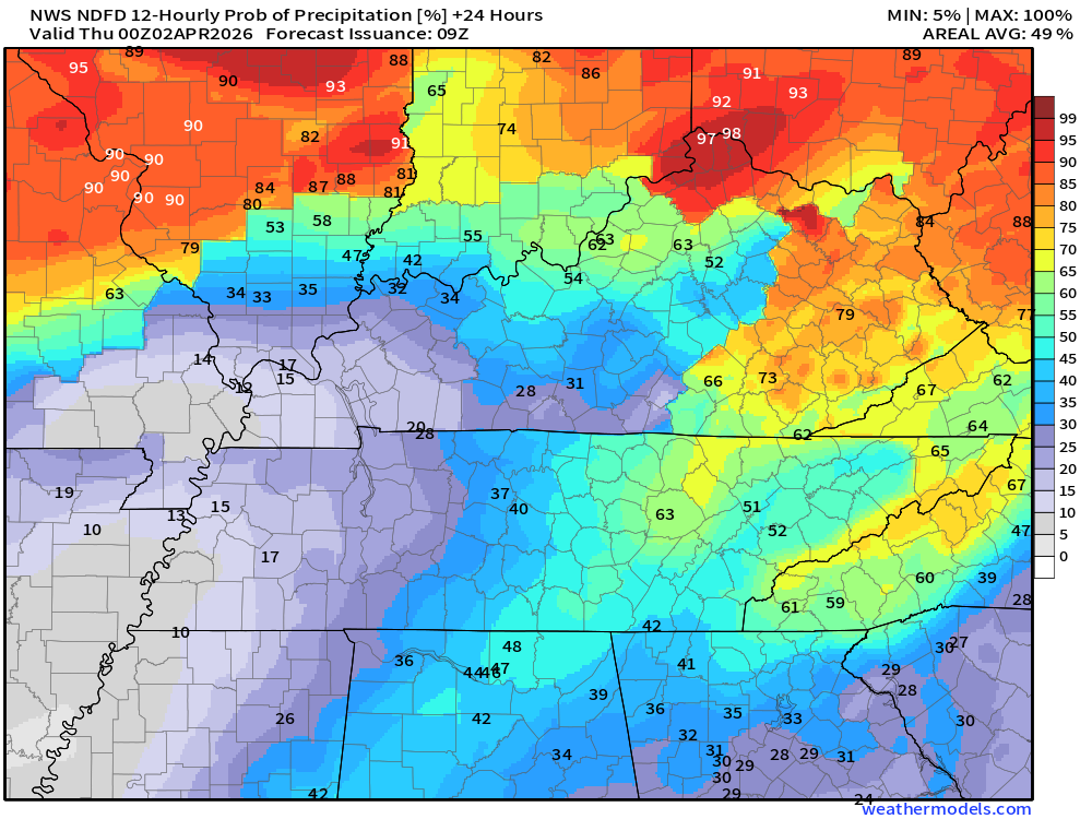
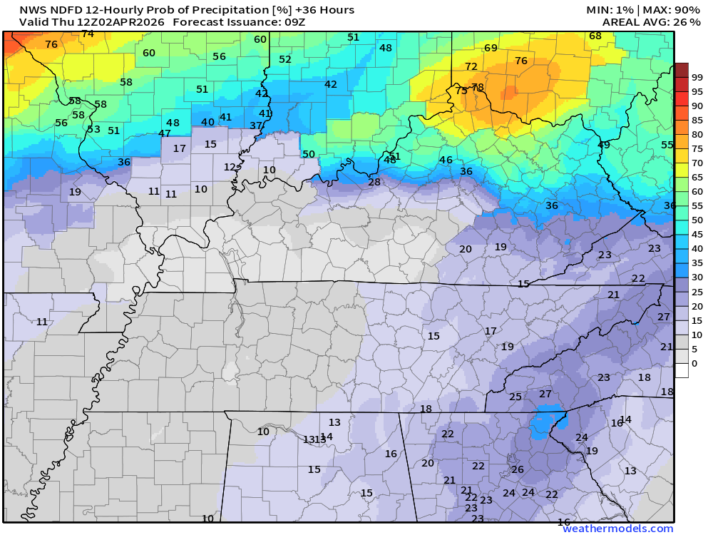
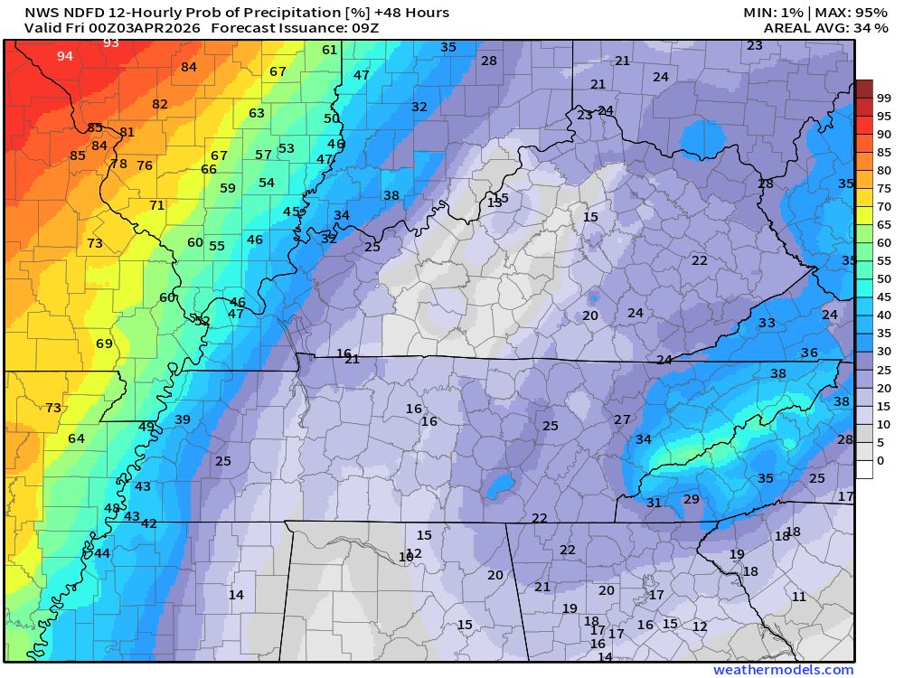
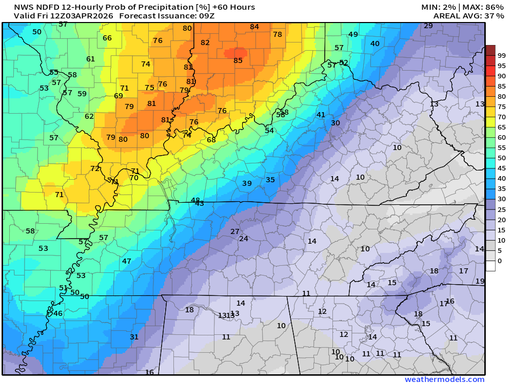
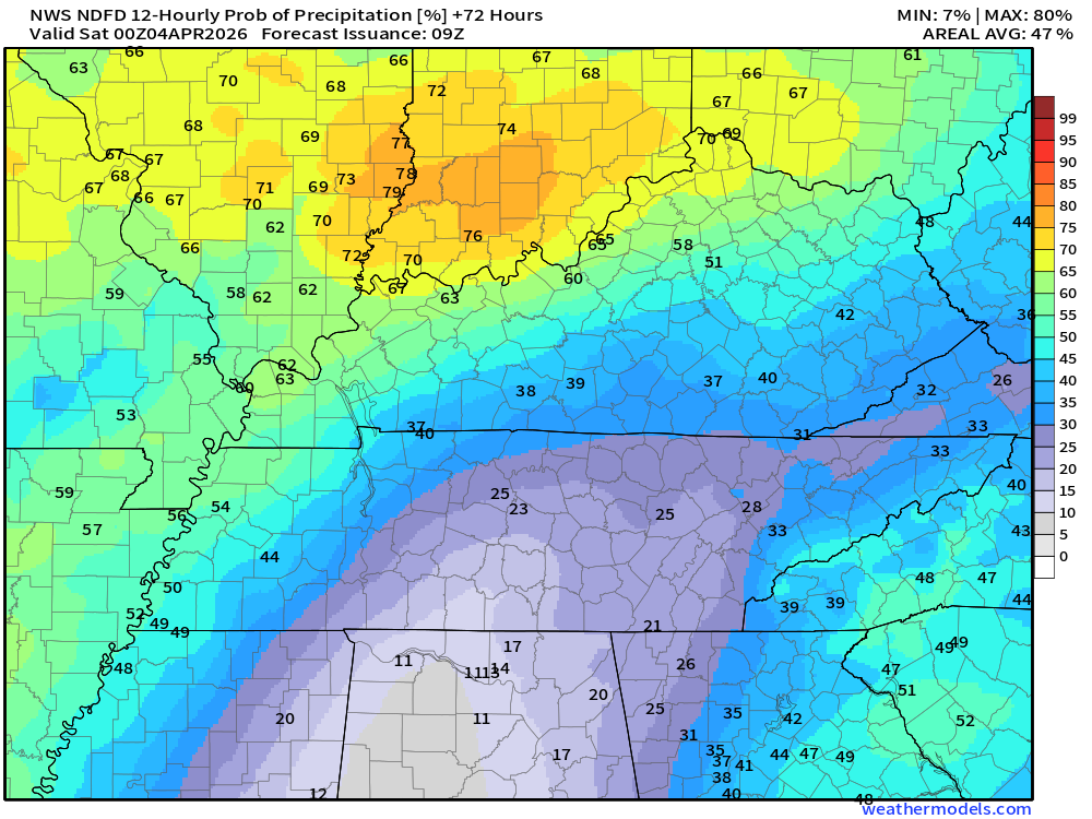
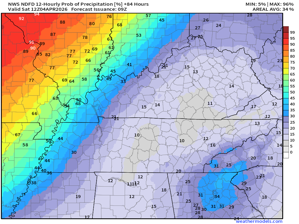
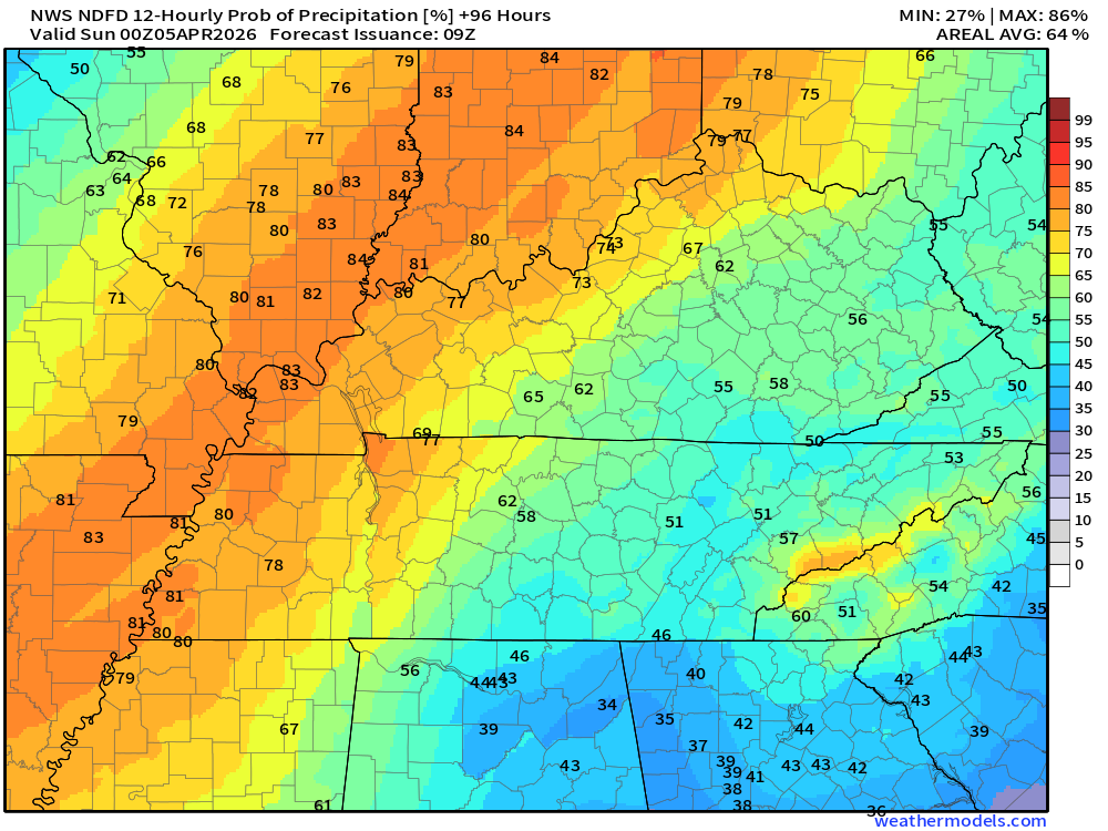
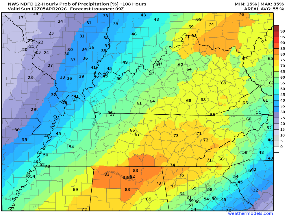
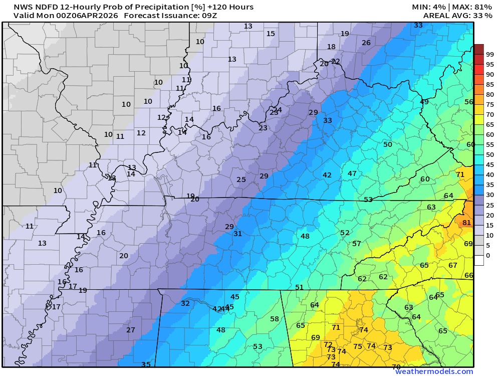
Let’s take a look at the twelve-hour rainfall probabilities. What is the % chance of showers and thunderstorms?
Keep in mind, this is a series of systems. Rain coverage will ebb and flow. Higher during some twelve-hour periods and lower during some twelve-hour periods.
There were some adjustments in these maps over the last 24 hours.
What is the % chance of showers and thunderstorms?
Double-click on images to enlarge them.
Wednesday 7 AM to 7 PM
.
Wednesday night 7 PM to Thursday 7 AM
.
Thursday 7 AM to 7 PM
Double-click on images to enlarge them.
.
.
Thursday 7 PM to Friday 7 AM
.
.
Friday 7 AM to 7 PM
.
.
Friday night 7 PM to Saturday 7 AM
Double-click on images to enlarge them.
.
.
Saturday 7 AM to 7 PM
.
.
Saturday night 7 PM to Sunday 7 AM
.
.
Sunday 7 AM to 7 PM
I am hoping these numbers come down (for Sunday).
.
.
Monday through Wednesday of next week should be dry.
I can’t rule out light frost on Monday morning. Lows will be in the mid to upper 30s over most of the region.
.

.
The timestamp (upper left) is in Zulu. 12z=7 am. 18z=1 pm. 00z=7 pm.
Green is rain. Yellow is moderate rain. Orange indicates locally heavy rain.
This model pops most of the storms east northeast of our region (on Thursday PM)
Double-click the animation to enlarge it.
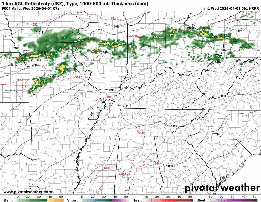
GFS Model
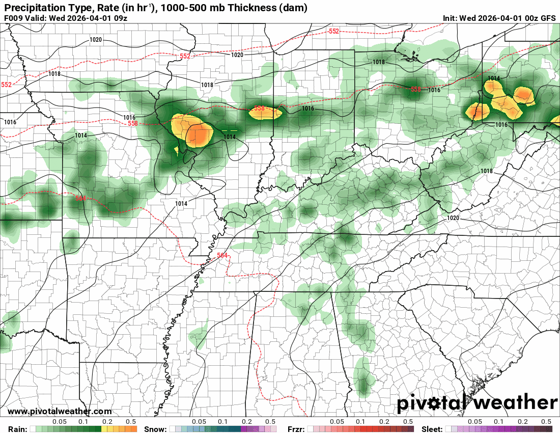
.
The timestamp (upper left) is in Zulu. 12z=7 am. 18z=1 pm. 00z=7 pm.
Green is rain. Yellow is moderate rain. Orange indicates locally heavy rain.
Double-click the animation to enlarge it.
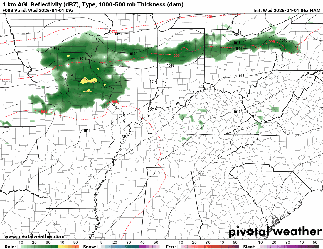
NAM Model
.
.
The timestamp (upper left) is in Zulu. 12z=7 am. 18z=1 pm. 00z=7 pm.
Green is rain. Yellow is moderate rain. Orange indicates locally heavy rain.
Double-click the animation to enlarge it.
RRFS Model
.
..
.
Click here if you would like to return to the top of the page.
.Average high temperatures for this time of the year are around 66 degrees.
Average low temperatures for this time of the year are around 42 degrees.
Average precipitation during this time period ranges from 1.00″ to 1.20″
Six to Ten Day Outlook.
Blue is below average. Red is above average. The no color zone represents equal chances.
Average highs for this time of the year are in the lower 60s. Average lows for this time of the year are in the lower 40s.

Green is above average precipitation. Yellow and brown favors below-average precipitation. Average precipitation for this time of the year is around one inch per week.

.

Average low temperatures for this time of the year are around 43 degrees.
Average precipitation during this time period ranges from 1.00″ to 1.30″
.
Eight to Fourteen Day Outlook.
Blue is below average. Red is above average. The no color zone represents equal chances.

Green is above average precipitation. Yellow and brown favors below average precipitation. Average precipitation for this time of the year is around one inch per week.

.
.
.
We have a new service to complement your www.weathertalk.com subscription. This does NOT replace www.weathertalk.com It is simply another tool for you to receive severe weather information.
.
https://weathercallservices.com/beau-dodson-weather


Want to receive the daily forecast/other products on your Beau Dodson Weather app?
Did you know you have four options in your www.weathertalk.com account
You will then receive these via your Beau Dodson Weather app.
Just log into your www.weathertalk.com account
Click the NOTIFICATION SETTINGS TAB
Then, turn them on (green) and off (red)
🌪️ Number 1 is the most important one. Severe alerts, tornado alerts, and so on.
Number 2 is the daily video, blog, livestream alerts, and severe weather Facebook threads on severe days or winter storm days.
Number 3 is the daily forecast. I send that out every day during the afternoon hours. It is the seven-day forecast, hazardous weather outlook, fire outlook, and more.
Number 4 is to receive the daily video, blog, and other content on NON-severe weather days (every day without severe threats in other words)
GREEN IS ON
RED IS OFF

I am going to start going live during bigger severe weather events.
Check it out here https://www.youtube.com/user/beaudodson
Click the subscribe button (it’s a free subscription button), and it will alert you when I go live. I will also send out alerts to the app when I go live for an event.

.

Radars and Lightning Data
Interactive-city-view radars. Clickable watches and warnings.
https://wtalk.co/B3XHASFZ
Old legacy radar site (some of you like it better)
https://weatherobservatory.com/weather-radar.htm
If the radar is not updating then try another one. If a radar does not appear to be refreshing then hit Ctrl F5. You may also try restarting your browser.
Backup radar site in case the above one is not working.
https://weathertalk.com/morani
Regional Radar
https://imagery.weathertalk.com/prx/RadarLoop.mp4
** NEW ** Zoom radar with chaser tracking abilities!
ZoomRadar
If the radar is not working, then email me: Email me at beaudodson@usawx.com
.
We do have some sponsors! Check them out.
Roof damage from recent storms? Link – Click here
INTEGRITY ROOFING AND EXTERIORS!
⛈️ Roof or gutter damage from recent storms? Today’s weather is sponsored by Integrity Roofing. Check out their website at this link https://www.ourintegritymatters.com/

![]()
![]()
![]()
Make sure you have three to five ways of receiving your severe weather information.
Weather Talk is one of those ways! Now, I have another product for you and your family.

.
Want to add more products to your Beau Dodson Weather App?
Receive daily videos, weather blog updates on normal weather days and severe weather and winter storm days, your county by county weather forecast, and more!
Here is how to do add those additional products to your app notification settings!
Here is a video on how to update your Beau Dodson Weather payment.
The app is for subscribers. Subscribe at www.weathertalk.com/welcome then go to your app store and search for WeatherTalk
Subscribers, PLEASE USE THE APP. ATT and Verizon are not reliable during severe weather. They are delaying text messages.
The app is under WeatherTalk in the app store.

Apple users click here

Android users click here
.
Radars and Lightning Data
Interactive-city-view radars. Clickable watches and warnings.
https://wtalk.co/B3XHASFZ
Old legacy radar site (some of you like it better)
https://weatherobservatory.com/weather-radar.htm
If the radar is not updating then try another one. If a radar does not appear to be refreshing then hit Ctrl F5. You may also try restarting your browser.
Backup radar site in case the above one is not working.
https://weathertalk.com/morani
Regional Radar
https://imagery.weathertalk.com/prx/RadarLoop.mp4
** NEW ** Zoom radar with chaser tracking abilities!
ZoomRadar
Lightning Data (zoom in and out of your local area)
https://wtalk.co/WJ3SN5UZ
Not working? Email me at beaudodson@usawx.com
National map of weather watches and warnings. Click here.
Storm Prediction Center. Click here.
Weather Prediction Center. Click here.
.

Live lightning data: Click here.
Real time lightning data (another one) https://map.blitzortung.org/#5.02/37.95/-86.99
Our new Zoom radar with storm chases
.
.

Interactive GOES R satellite. Track clouds. Click here.
GOES 16 slider tool. Click here.
College of DuPage satellites. Click here
.

Here are the latest local river stage forecast numbers Click Here.
Here are the latest lake stage forecast numbers for Kentucky Lake and Lake Barkley Click Here.
.
.
Find Beau on Facebook! Click the banner.


 .
.