
Click one of the links below to take you directly to that section
Do you have any suggestions or comments? Email me at beaudodson@usawx.com
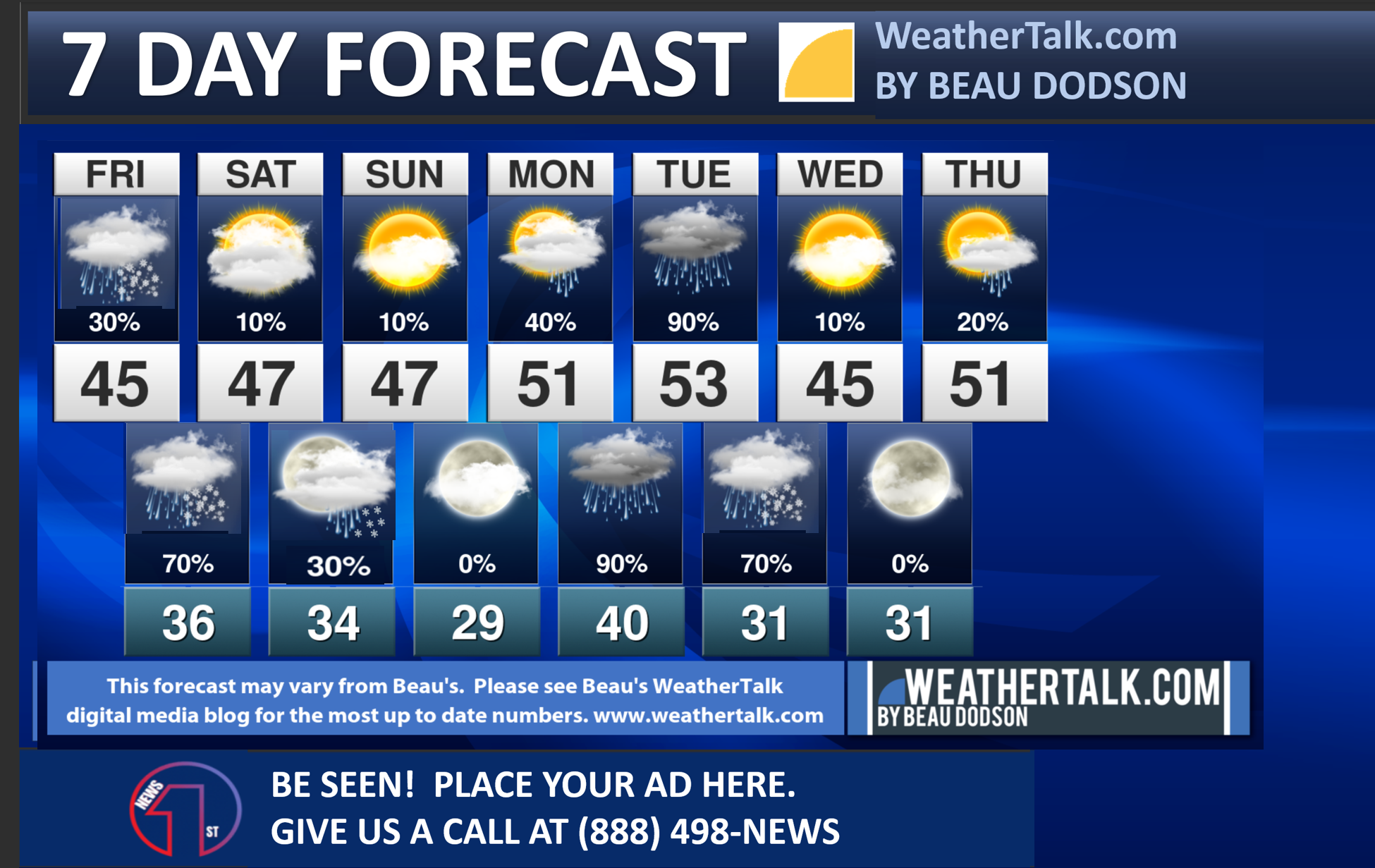
Seven-day forecast for southeast Missouri, southern Illinois, western Kentucky, and western Tennessee.
This is a BLEND for the region. Scroll down to see the region by region forecast.
THE FORECAST IS GOING TO VARY FROM LOCATION TO LOCATION. Scroll down to see the region by region forecast.
SPECIAL WEATHER STATEMENT
Winter Weather Update.
Friday, January 5, 2024.
Counties
Butler, Stoddard, Bollinger, Cape Girardeau, Perry, and Ste Genevieve Counties
Randolph, Perry, Jackson, Franklin, Union, Hamilton, Williamson, and Jefferson Counties
A rain/snow mix will move into southeast Missouri and southern Illinois this afternoon and tonight. Temperatures tonight will likely drop to near freezing.
It is possible that Stoddard, Cape Girardeau, Union, Williamson, Franklin, and Hamilton Counties remain mostly rain. I included them as a buffer zone along the area with a higher chance of snow (to the west/northwest).
A slushy accumulation of a dusting to an inch or so of snow will be possible in the above mentioned counties. The farther west/northwest you travel, the higher the probabilities for light accumulating snow.
Remember, bridges and overpasses freeze first. Some slick spots will be possible tonight into early tomorrow morning.
.
.
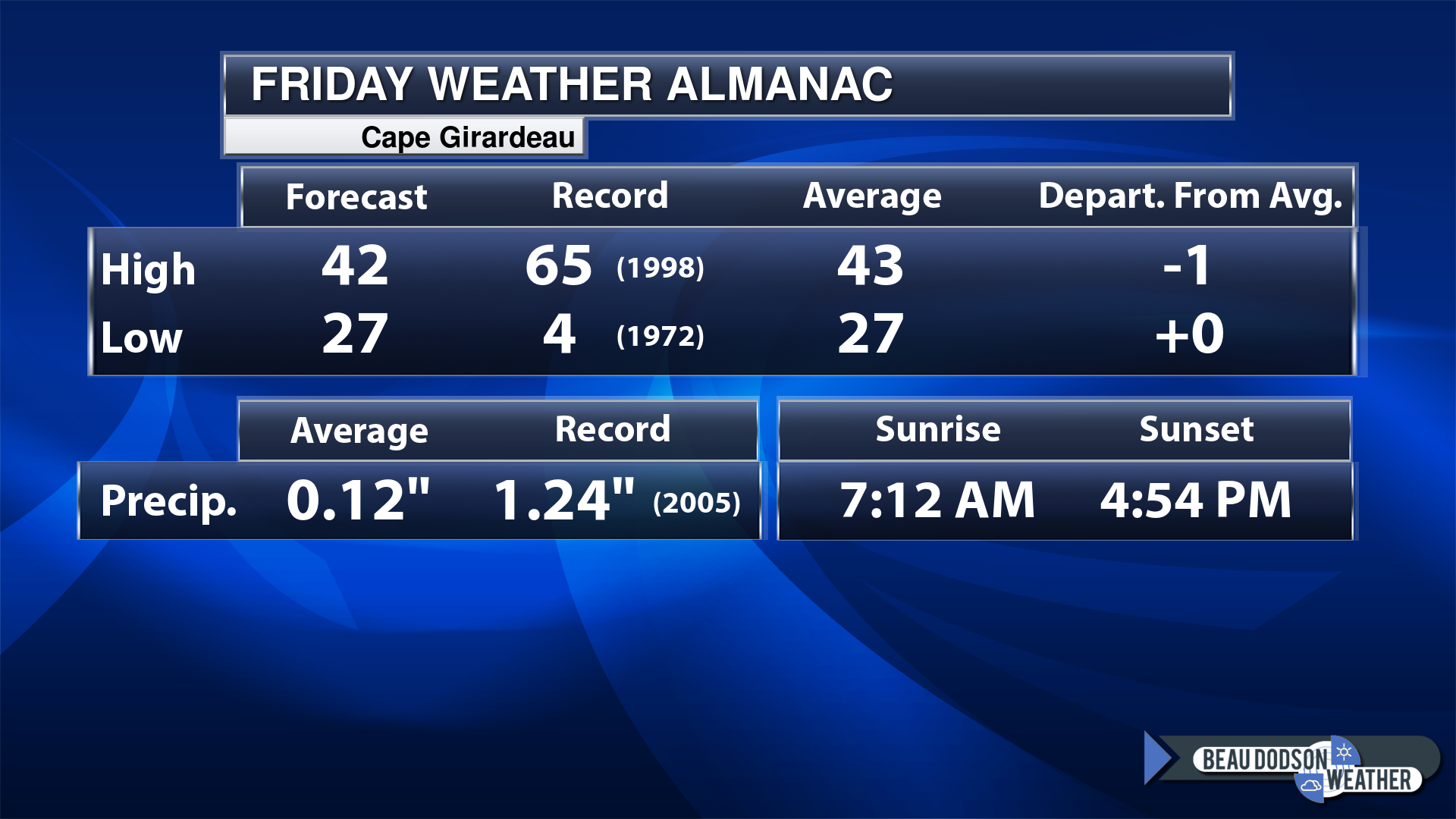
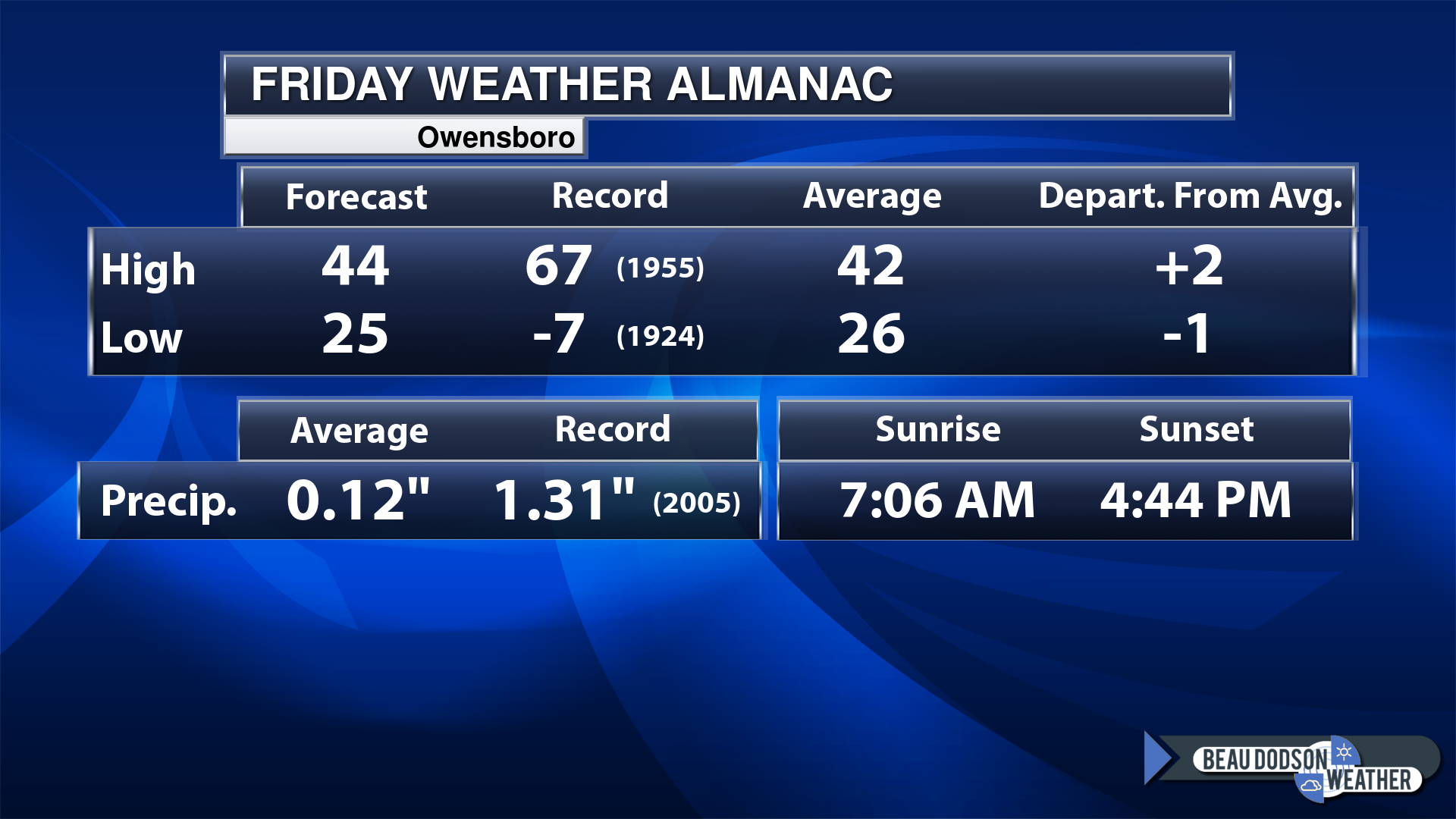
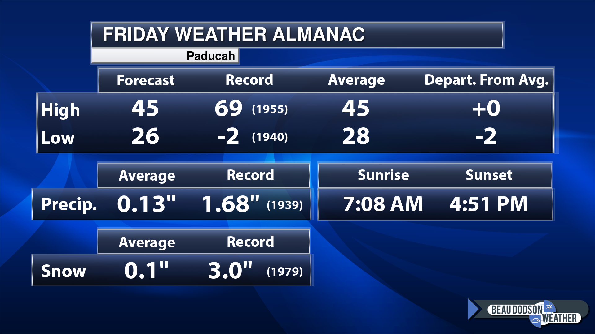
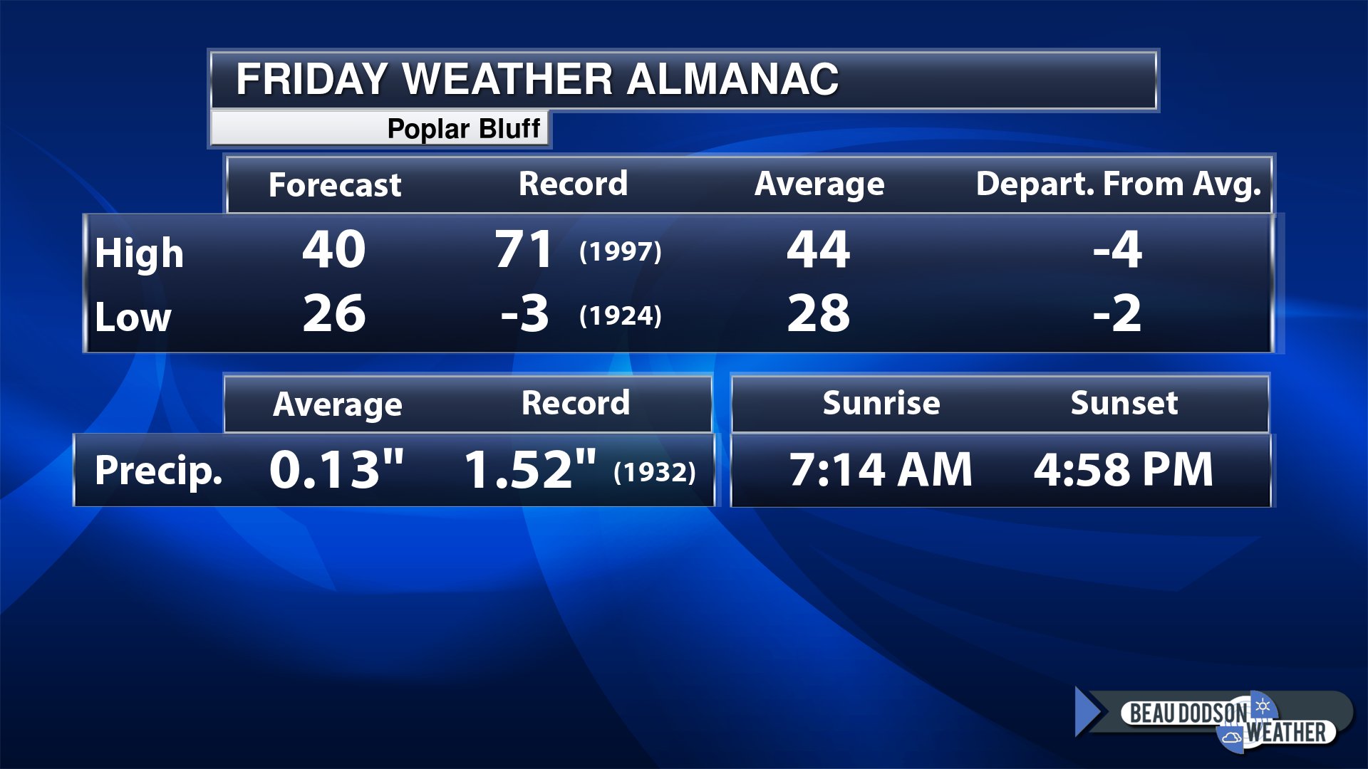
Today’s Local Almanacs (for a few select cities). Your location will be comparable.
Note, the low is this morning’s low and not tomorrows.
Today’s almanac numbers from a few select local cities.
The forecast temperature shows you today’s expected high and this morning’s low.
The graphic shows you the record high and record low for today. It shows you what year that occurred, as well.
It then shows you what today’s average temperature is.
Then, it shows you the departures (how may degrees above or below average temperatures will be ).
It shows you the average precipitation for today. Average comes from thirty years of rain totals.
It also shows you the record rainfall for the date and what year that occurred.
The sunrise and sunset are also shown.
If you have not subscribed to my YouTube Channel then click on this link and it will take you to my videos.
Click the button below and it will take you to the Beau Dodson YouTube Channel.
48-hour forecast


.

.
Friday to Friday
1. Is lightning in the forecast? Monitor. I am watching a storm system next Monday night and Tuesday.
2. Are severe thunderstorms in the forecast? Monitor. I am watching a storm system next Monday night and Tuesday. The risk of severe weather will likely remain to our south and southeast.
3. Is flash flooding in the forecast? Not at this time.
4. Will the heat index exceed 100 degrees? No.
5. Will the wind chill dip below 10 degrees? No.
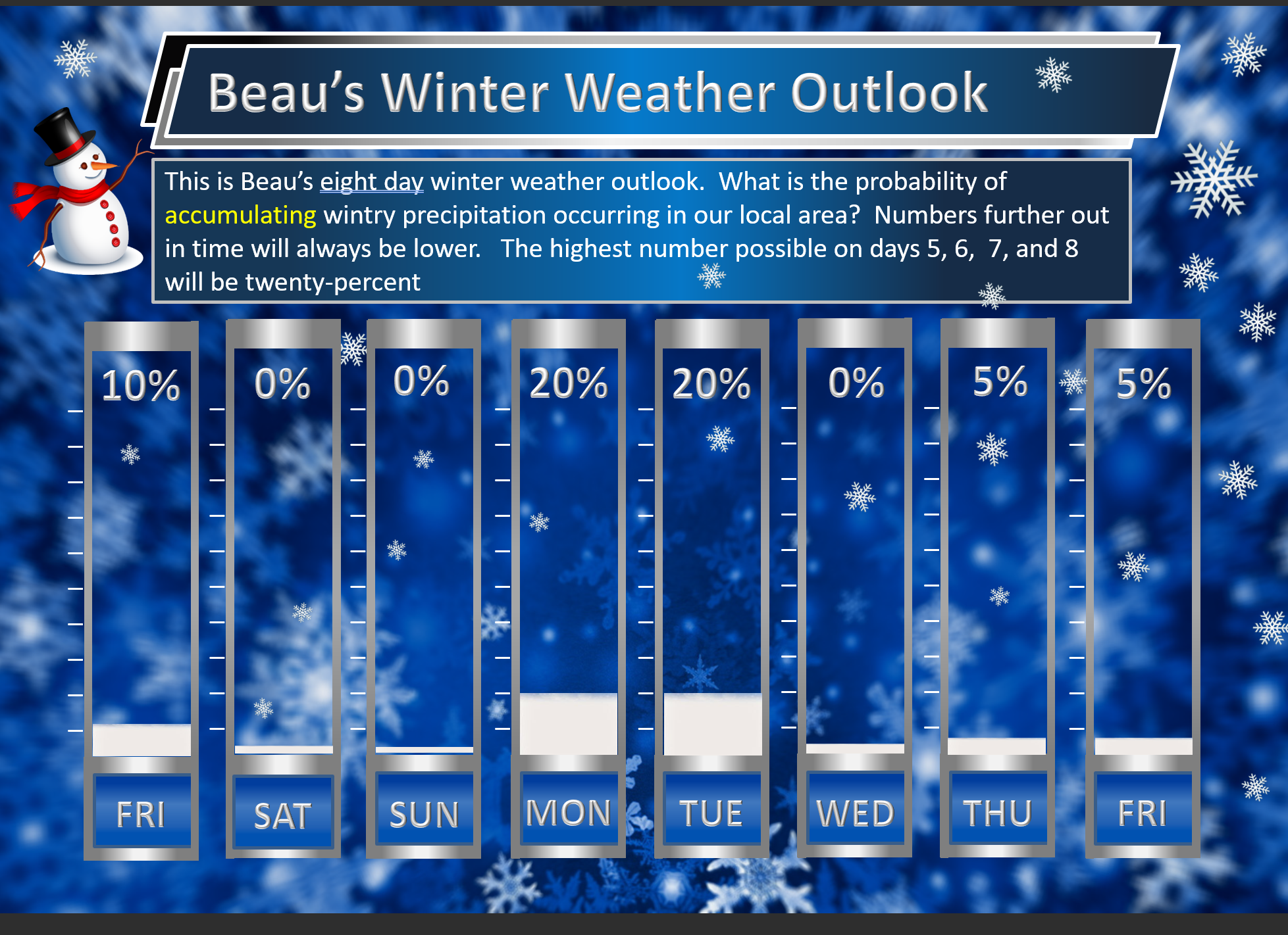
6. Is measurable snow and/or sleet in the forecast? Possible. A light dusting of snow is possible over southeast Missouri and portions of southern Illinois later today into tomorrow morning. Mainly from Butler County northeast into Bollinger County and then northeast towards Mt Vernon. Temperatures will be marginal for accumulation or impacts. But, a slushy dusting can’t be ruled out. Watch bridges and overpasses.
I am watching another system Monday night into Tuesday night. Depending on the track of the area of low pressure, there could be measurable snow over portions of the region. I am watching MO/IL. Monitor updates. If the low tracks farther south and east, then the snow would shift south and east.
I am watching a fast moving system next Wednesday and Thursday.
I am watching a system next Friday into Sunday.
7. Is freezing rain/ice in the forecast? Monitor. I am watching a system Monday night into Tuesday night.
I am watching two more systems after that. I can’t rule out wintry precipitation. Monitor updates.
Freezing rain is rain that falls and instantly freezes on objects such as trees and power lines
.
Fire weather risk level.
Friday: 2. Very low risk.
Friday night: 2. Very low risk.
Saturday: 2. Very low risk.
Saturday night: 4. Low risk.
Fire Weather Discussion
Rain chances enter SEMO this afternoon, with rain becoming widespread for the evening and overnight hours. Some mixing of light snow is possible in northwestern portions of the Quad State, with no more than a light dusting of snow on grassy surfaces. Light rain chances briefly return Saturday night. Dry conditions are expected Sunday through Monday morning as winds become breezy Monday. Rain moves into the western half of the forecast area Monday afternoon, becoming widespread Monday evening through Tuesday, with more substantial rainfall amounts over an inch and gusty winds. Some mixing of snow will again be possible, most likely in northwestern portions of the Quad State.
A Haines Index of 6 means a high potential for an existing fire to become large or exhibit erratic fire behavior, 5 means medium potential, 4 means low potential, and anything less than 4 means very low potential.
.
.
Friday, January 05, 2024
Confidence in the forecast? High Confidence
Friday Forecast: Increasing clouds. A chance of late afternoon showers. Rain may mix with snow over southeast Missouri and southwest Illinois. Along a line from Butler County to Bollinger County and then northeast to Mt Vernon. Otherwise, rain is expected across the rest of the area.
What is the chance of precipitation?
Far northern southeast Missouri ~ 40%
Southeast Missouri ~ 40%
The Missouri Bootheel ~ 40%
I-64 Corridor of southern Illinois ~ 0%
Southern Illinois ~ 0%
Extreme southern Illinois (southern seven counties) ~ 20%
Far western Kentucky (Purchase area) ~ 20%
The Pennyrile area of western KY ~ 0%
Northwest Kentucky (near Indiana border) ~ 0%
Northwest Tennessee ~ 30%
Coverage of precipitation: Widely scattered late in the day
Timing of the precipitation: After 4 PM
Far northern southeast Missouri ~ 40° to 42°
Southeast Missouri ~ 42° to 44°
The Missouri Bootheel ~ 44° to 46°
I-64 Corridor of southern Illinois ~ 40° to 42°
Southern Illinois ~ 42° to 44°
Extreme southern Illinois (southern seven counties) ~ 42° to 44°
Far western Kentucky ~ 42° to 45°
The Pennyrile area of western KY ~ 42° to 45°
Northwest Kentucky (near Indiana border) ~ 42° to 44°
Northwest Tennessee ~ 44° to 48°
Winds will be from this direction: Southeast 6 to 12 mph
Wind chill or heat index (feels like) temperature forecast: 38° to 44°
What impacts are anticipated from the weather? Wet roadways.
Should I cancel my outdoor plans? No, but monitor the Beau Dodson Weather Live Radars
UV Index: 1. Low.
Sunrise: 7:10 AM
Sunset: 4:51 PM .
.
Friday Night Forecast: Rain likely. Rain may mix with snow over southeast Missouri and southwest Illinois. Along a line from Butler County to Bollinger County and then northeast to Mt Vernon. Otherwise, rain is expected across the rest of the area. Slushy snow accumulation possible over portions of SE MO and SW IL.
What is the chance of precipitation?
Far northern southeast Missouri ~ 80%
Southeast Missouri ~ 80%
The Missouri Bootheel ~ 100%
I-64 Corridor of southern Illinois ~ 80%
Southern Illinois ~ 80%
Extreme southern Illinois (southern seven counties) ~ 90%
Far western Kentucky (Purchase area) ~ 100%
The Pennyrile area of western KY ~ 80%
Northwest Kentucky (near Indiana border) ~ 70%
Northwest Tennessee ~ 90%
Coverage of precipitation: Numerous
Timing of the precipitation: Any given point of time.
Temperature range:
Far northern southeast Missouri ~ 32° to 34°
Southeast Missouri ~ 32° to 32°
The Missouri Bootheel ~ 33° to 36°
I-64 Corridor of southern Illinois ~ 32° to 34°
Southern Illinois ~ 33° to 36°
Extreme southern Illinois (southern seven counties) ~ 33° to 36°
Far western Kentucky ~ 33° to 36°
The Pennyrile area of western KY ~ 33° to 36°
Northwest Kentucky (near Indiana border) ~ 33° to 36°
Northwest Tennessee ~ 33° to 36°
Winds will be from this direction: Southeast 6 to 12 mph
Wind chill or heat index (feels like) temperature forecast: 28° to 34°
What impacts are anticipated from the weather? Wet roadways. Monitor updates concerning icy roads.
Should I cancel my outdoor plans? No, but monitor updates.
Moonrise: 1:13 AM
Moonset: 12:14 PM
The phase of the moon: Waning Crescent
.
Saturday, January 06, 2024
Confidence in the forecast? High Confidence
Saturday Forecast: Mostly cloudy. Rain ending west to east early in the day.
What is the chance of precipitation?
Far northern southeast Missouri ~ 20%
Southeast Missouri ~ 20%
The Missouri Bootheel ~ 20%
I-64 Corridor of southern Illinois ~ 30%
Southern Illinois ~ 40%
Extreme southern Illinois (southern seven counties) ~ 40%
Far western Kentucky (Purchase area) ~ 60%
The Pennyrile area of western KY ~ 60%
Northwest Kentucky (near Indiana border) ~ 60%
Northwest Tennessee ~ 60%
Coverage of precipitation: Scattered (ending)
Timing of the precipitation:
Far northern southeast Missouri ~ 42° to 44°
Southeast Missouri ~ 42° to 44°
The Missouri Bootheel ~ 44° to 46°
I-64 Corridor of southern Illinois ~ 40° to 42°
Southern Illinois ~ 42° to 44°
Extreme southern Illinois (southern seven counties) ~ 42° to 44°
Far western Kentucky ~ 42° to 45°
The Pennyrile area of western KY ~ 42° to 45°
Northwest Kentucky (near Indiana border) ~ 42° to 44°
Northwest Tennessee ~ 44° to 48°
Winds will be from this direction: Northwest 6 to 12 mph
Wind chill or heat index (feels like) temperature forecast: 38° to 44°
What impacts are anticipated from the weather?
Should I cancel my outdoor plans? No
UV Index: 2. Low.
Sunrise: 7:10 AM
Sunset: 4:52 PM .
.
Saturday Night Forecast: Intervals of clouds. A chance of rain and snow showers.
What is the chance of precipitation?
Far northern southeast Missouri ~ 30%
Southeast Missouri ~ 30%
The Missouri Bootheel ~ 30%
I-64 Corridor of southern Illinois ~ 30%
Southern Illinois ~ 40%
Extreme southern Illinois (southern seven counties) ~ 40%
Far western Kentucky (Purchase area) ~ 40%
The Pennyrile area of western KY ~ 40%
Northwest Kentucky (near Indiana border) ~ 40%
Northwest Tennessee ~ 40%
Coverage of precipitation: Scattered
Timing of the precipitation: Any given point of time.
Temperature range:
Far northern southeast Missouri ~ 32° to 34°
Southeast Missouri ~ 32° to 34°
The Missouri Bootheel ~ 32° to 34°
I-64 Corridor of southern Illinois ~ 32° to 34°
Southern Illinois ~ 32° to 34°
Extreme southern Illinois (southern seven counties) ~ 32° to 34°
Far western Kentucky ~ 33° to 36°
The Pennyrile area of western KY ~ 33° to 36°
Northwest Kentucky (near Indiana border) ~ 32° to 34°
Northwest Tennessee ~ 33° to 36°
Winds will be from this direction: West 6 to 12 mph
Wind chill or heat index (feels like) temperature forecast: 28° to 32°
What impacts are anticipated from the weather? Wet roadways.
Should I cancel my outdoor plans? No
Moonrise: 2:15 AM
Moonset: 12:42 PM
The phase of the moon: Waning Crescent
.
Sunday, January 07, 2024
Confidence in the forecast? High Confidence
Sunday Forecast: Intervals of clouds. A slight chance of showers.
What is the chance of precipitation?
Far northern southeast Missouri ~ 0%
Southeast Missouri ~ 0%
The Missouri Bootheel ~ 0%
I-64 Corridor of southern Illinois ~ 0%
Southern Illinois ~ 20%
Extreme southern Illinois (southern seven counties) ~ 20%
Far western Kentucky (Purchase area) ~ 20%
The Pennyrile area of western KY ~ 20%
Northwest Kentucky (near Indiana border) ~ 20%
Northwest Tennessee ~ 20%
Coverage of precipitation: Isolated
Timing of the precipitation: Before noon
Far northern southeast Missouri ~ 43° to 46°
Southeast Missouri ~ 44° to 48°
The Missouri Bootheel ~ 44° to 48°
I-64 Corridor of southern Illinois ~ 40° to 42°
Southern Illinois ~ 43° to 46°
Extreme southern Illinois (southern seven counties) ~ 43° to 46°
Far western Kentucky ~ 44° to 48°
The Pennyrile area of western KY ~ 44° to 48°
Northwest Kentucky (near Indiana border) ~ 43° to 46°
Northwest Tennessee ~ 44° to 48°
Winds will be from this direction: West 8 to 16 mph
Wind chill or heat index (feels like) temperature forecast: 40° to 48°
What impacts are anticipated from the weather?
Should I cancel my outdoor plans? No
UV Index: 2. Low.
Sunrise: 7:10 AM
Sunset: 4:53 PM .
.
Sunday Night Forecast: Intervals of clouds.
What is the chance of precipitation?
Far northern southeast Missouri ~ 0%
Southeast Missouri ~ 0%
The Missouri Bootheel ~ 0%
I-64 Corridor of southern Illinois ~ 0%
Southern Illinois ~ 0%
Extreme southern Illinois (southern seven counties) ~ 0%
Far western Kentucky (Purchase area) ~ 0%
The Pennyrile area of western KY ~ 0%
Northwest Kentucky (near Indiana border) ~ 0%
Northwest Tennessee ~ 0%
Coverage of precipitation:
Timing of the precipitation:
Temperature range:
Far northern southeast Missouri ~ 30° to 34°
Southeast Missouri ~ 32° to 34°
The Missouri Bootheel ~ 32° to 34°
I-64 Corridor of southern Illinois ~ 30° to 32°
Southern Illinois ~ 30° to 32°
Extreme southern Illinois (southern seven counties) ~ 32° to 34°
Far western Kentucky ~ 32° to 34°
The Pennyrile area of western KY ~ 32° to 34°
Northwest Kentucky (near Indiana border) ~ 32° to 34°
Northwest Tennessee ~ 32° to 34°
Winds will be from this direction: East 10 to 20 mph
Wind chill or heat index (feels like) temperature forecast: 28° to 34°
What impacts are anticipated from the weather?
Should I cancel my outdoor plans? No
Moonrise: 3:21 AM
Moonset: 1:16 PM
The phase of the moon: Waning Crescent
.
Monday, January 08, 2024
Confidence in the forecast? High Confidence
Monday Forecast: Mostly cloudy. A chance of rain.
What is the chance of precipitation?
Far northern southeast Missouri ~ 60%
Southeast Missouri ~ 60%
The Missouri Bootheel ~ 60%
I-64 Corridor of southern Illinois ~ 60%
Southern Illinois ~ 60%
Extreme southern Illinois (southern seven counties) ~ 60%
Far western Kentucky (Purchase area) ~ 40%
The Pennyrile area of western KY ~ 40%
Northwest Kentucky (near Indiana border) ~ 40%
Northwest Tennessee ~ 60%
Coverage of precipitation: Becoming numerous.
Timing of the precipitation: Mainly after 12 PM
Far northern southeast Missouri ~ 43° to 46°
Southeast Missouri ~ 44° to 48°
The Missouri Bootheel ~ 46° to 48°
I-64 Corridor of southern Illinois ~ 40° to 42°
Southern Illinois ~ 43° to 46°
Extreme southern Illinois (southern seven counties) ~ 43° to 46°
Far western Kentucky ~ 46° to 50°
The Pennyrile area of western KY ~ 48° to 52°
Northwest Kentucky (near Indiana border) ~ 43° to 46°
Northwest Tennessee ~ 48° to 52°
Winds will be from this direction: East increasing to 10 to 25 mph. Gusty.
Wind chill or heat index (feels like) temperature forecast: 40° to 48°
What impacts are anticipated from the weather? Wet roadways.
Should I cancel my outdoor plans? No, but monitor the forecast updates and the Beau Dodson Live Radars
UV Index: 1. Low.
Sunrise: 7:10 AM
Sunset: 4:54 PM .
.
Monday Night Forecast: Mostly cloudy. Rain likely. I will monitor the rain/snow line over MO/IL.
What is the chance of precipitation?
Far northern southeast Missouri ~ 100%
Southeast Missouri ~ 100%
The Missouri Bootheel ~ 100%
I-64 Corridor of southern Illinois ~ 100%
Southern Illinois ~ 100%
Extreme southern Illinois (southern seven counties) ~ 100%
Far western Kentucky (Purchase area) ~ 100%
The Pennyrile area of western KY ~ 100%
Northwest Kentucky (near Indiana border) ~ 100%
Northwest Tennessee ~ 100%
Coverage of precipitation: Widespread
Timing of the precipitation: Any given point of time.
Temperature range:
Far northern southeast Missouri ~ 34° to 36°
Southeast Missouri ~ 34° to 36°
The Missouri Bootheel ~ 38° to 40°
I-64 Corridor of southern Illinois ~ 33° to 36°
Southern Illinois ~ 34° to 36°
Extreme southern Illinois (southern seven counties) ~ 34° to 38°
Far western Kentucky ~ 38° to 42°
The Pennyrile area of western KY ~ 40° to 44°
Northwest Kentucky (near Indiana border) ~ 33° to 36°
Northwest Tennessee ~ 40° to 45°
Winds will be from this direction: East 15 to 35 mph. Gusty.
Wind chill or heat index (feels like) temperature forecast: 20° to 40°
What impacts are anticipated from the weather?
Should I cancel my outdoor plans? No
Moonrise: 4:30 AM
Moonset: 2:00 PM
The phase of the moon: Waning Crescent
.
.
Click here if you would like to return to the top of the page.
-
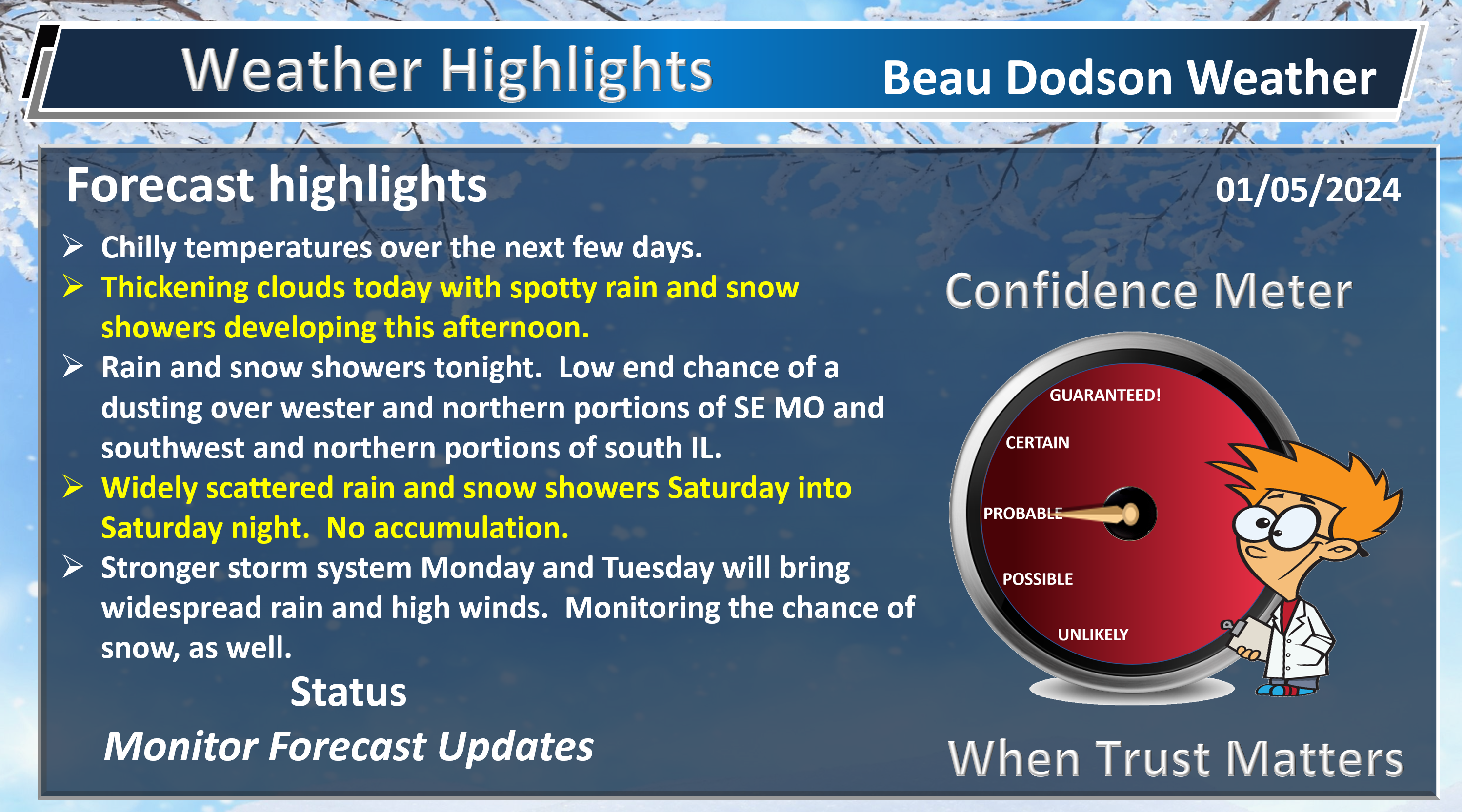
- Active weather pattern underway.
- Rain arrives tonight into Saturday. Light totals. Low chance of wet snow. over MO/IL
- A few showers Saturday night and early Sunday morning.
- A big storm system impacts the region Monday into Tuesday night with widespread showers and thunderstorms. Gusty strong winds. Monitor snow chances.
- Watching a system next Wednesday/Thursday.
- Additional systems after that.
Weather advice:
Make sure you have three to five ways of receiving your severe weather information.
Forecast Discussion
Good day, everyone.
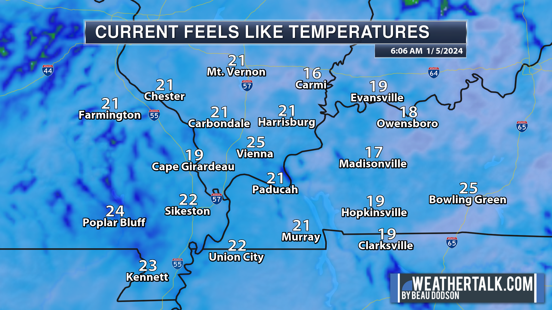
We are waking up to chilly temperatures. Check out the feels like temperatures as of 7 AM.
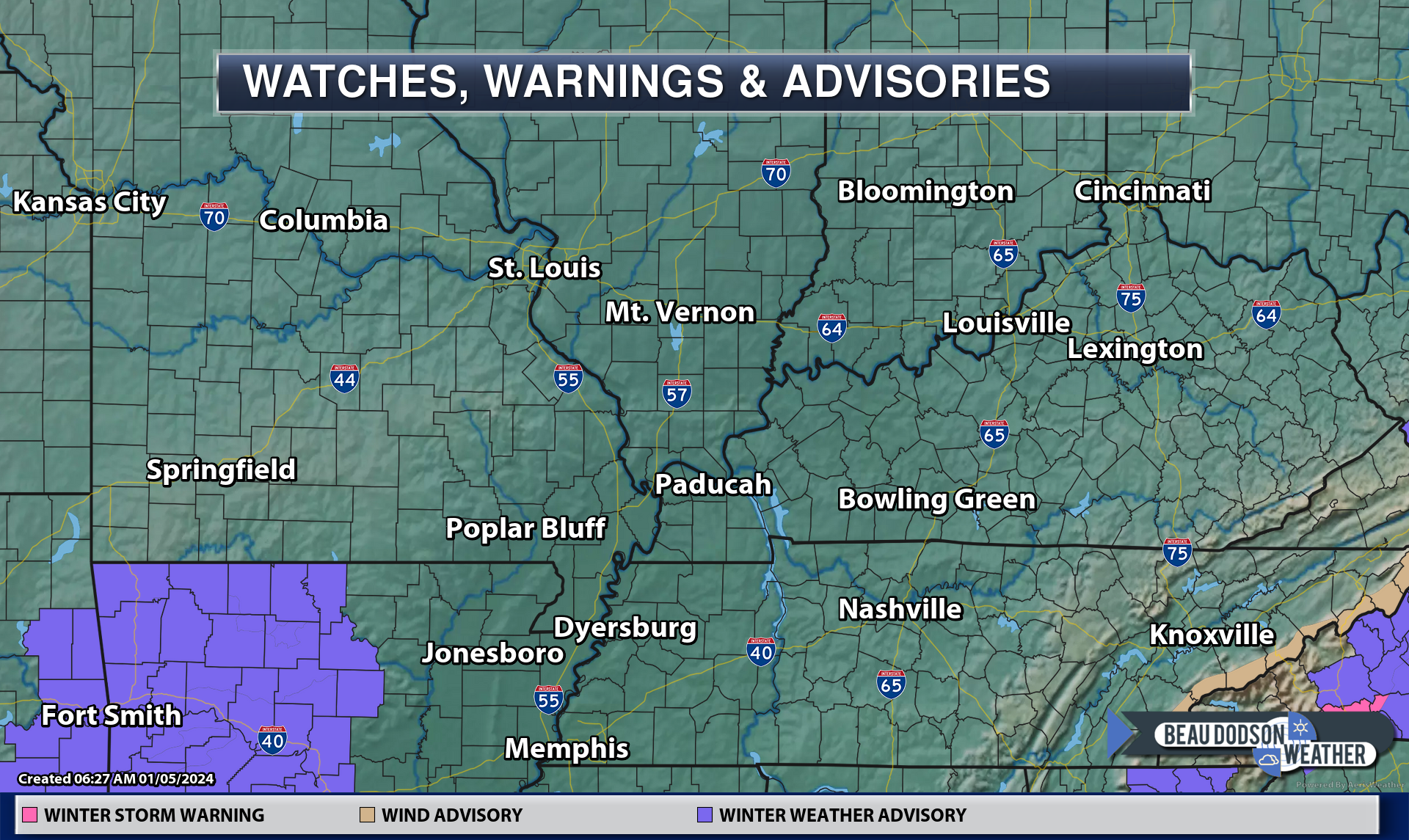
We check out the watches, advisories, and warnings and we see a winter weather advisory over portions of Arkansas.
I will be monitoring portions of southeast MO and southern IL for icy roads tonight.
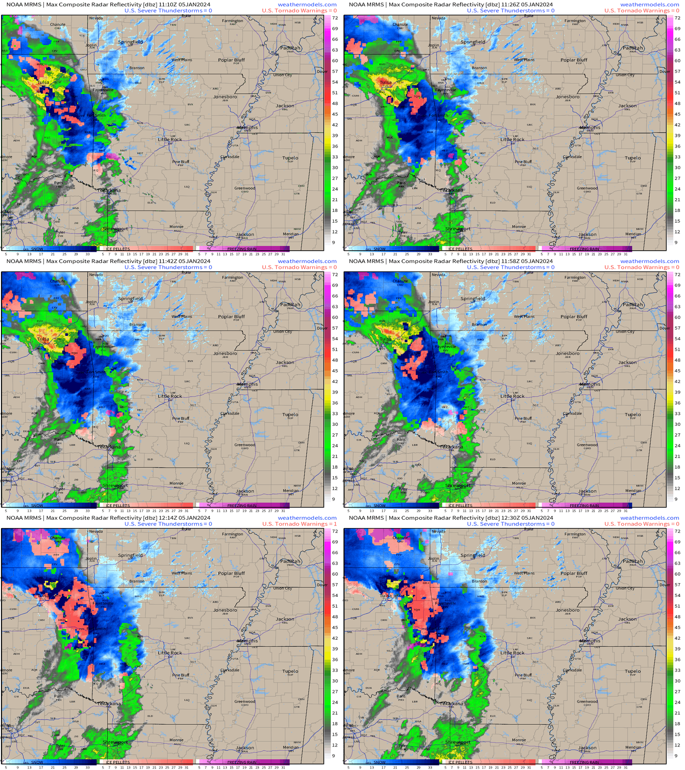
Radar shows rain and snow spreading northeast towards our region. This will arrive this afternoon into tonight. Rain for most of the region. A rain snow mix over southeast Missouri and southern Illinois.
There is a low end chance of a slushy accumulation over Butler County northeast to Bollinger County and then northeast to Mt Vernon, Illinois.
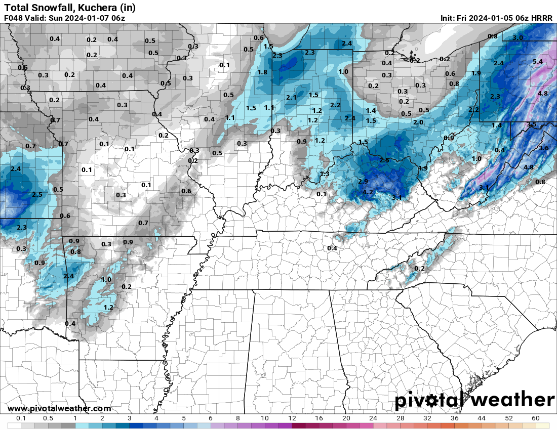
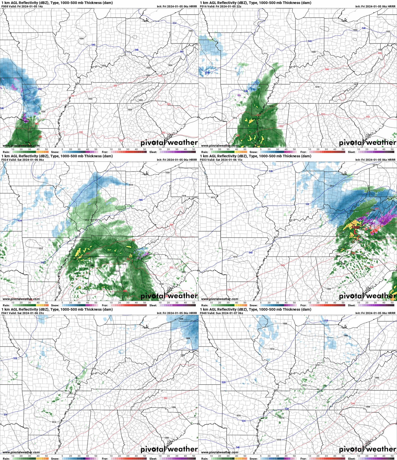
The Hrrr model shows very little accumulation potential.
Here was the 7 AM radar (scroll down for our live local winter radars)
All of that is spreading east northeast.
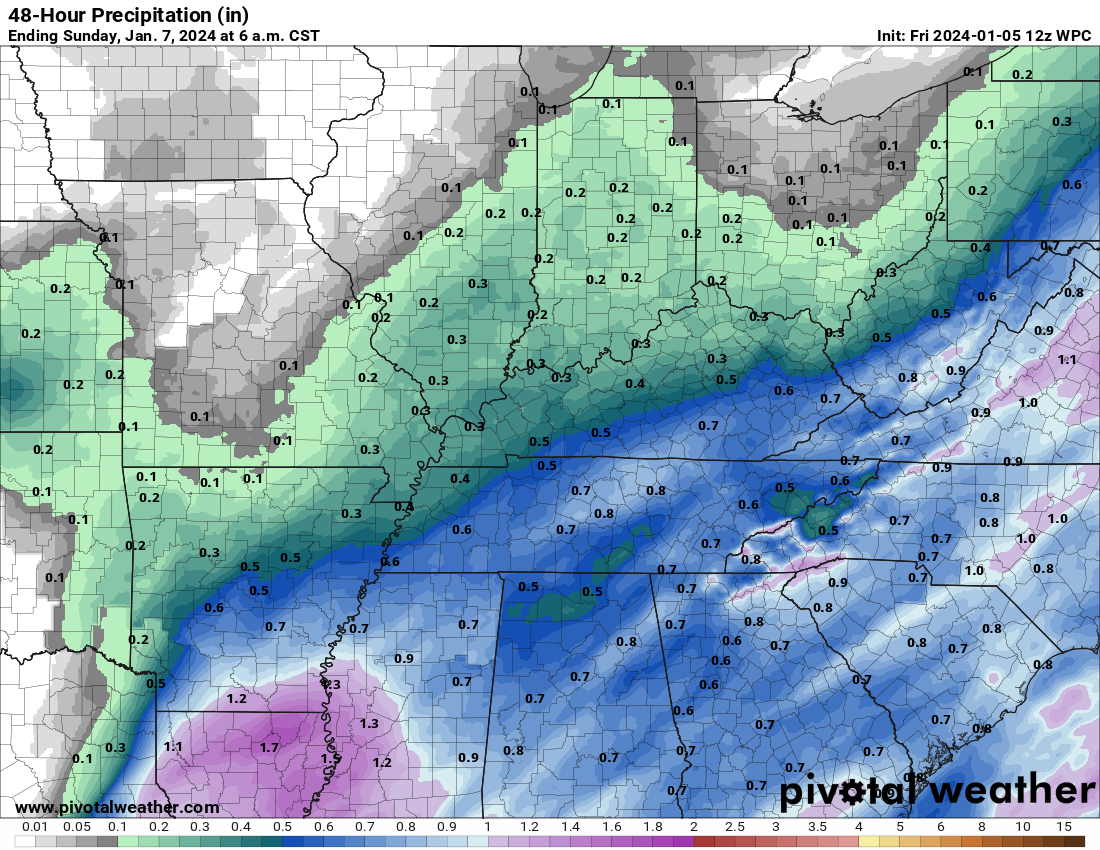
Here is the latest WPC/NOAA forecast for rain totals Friday/Saturday.
A few lingering showers or rain/snow showers will be possible Saturday night and Sunday morning.
Sunday will deliver a mix of sun and clouds. Another storm system will be approaching our region by Monday.
Clouds will thicken Sunday night and Monday. That will lead to our big storm system that we have been watching for a month. I had been predicting a big storm around January 10th. It will arrive a couple of days early.
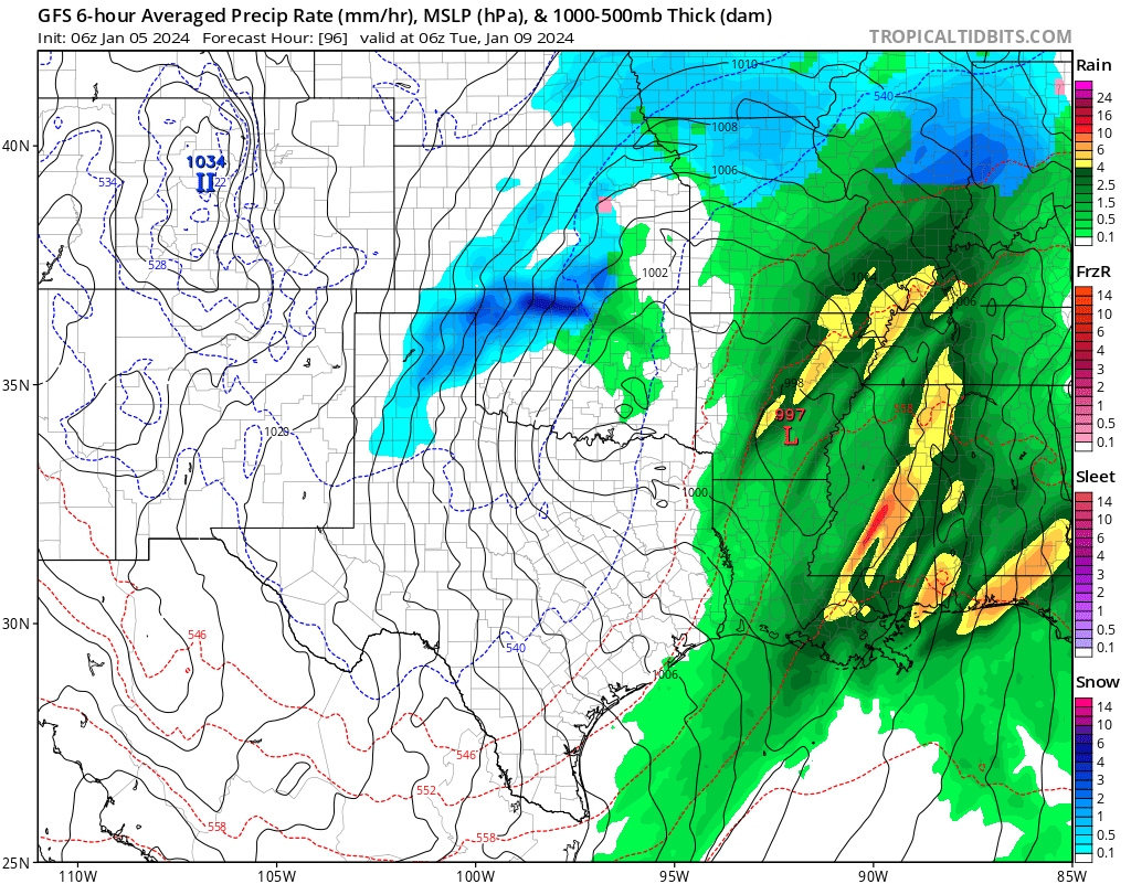
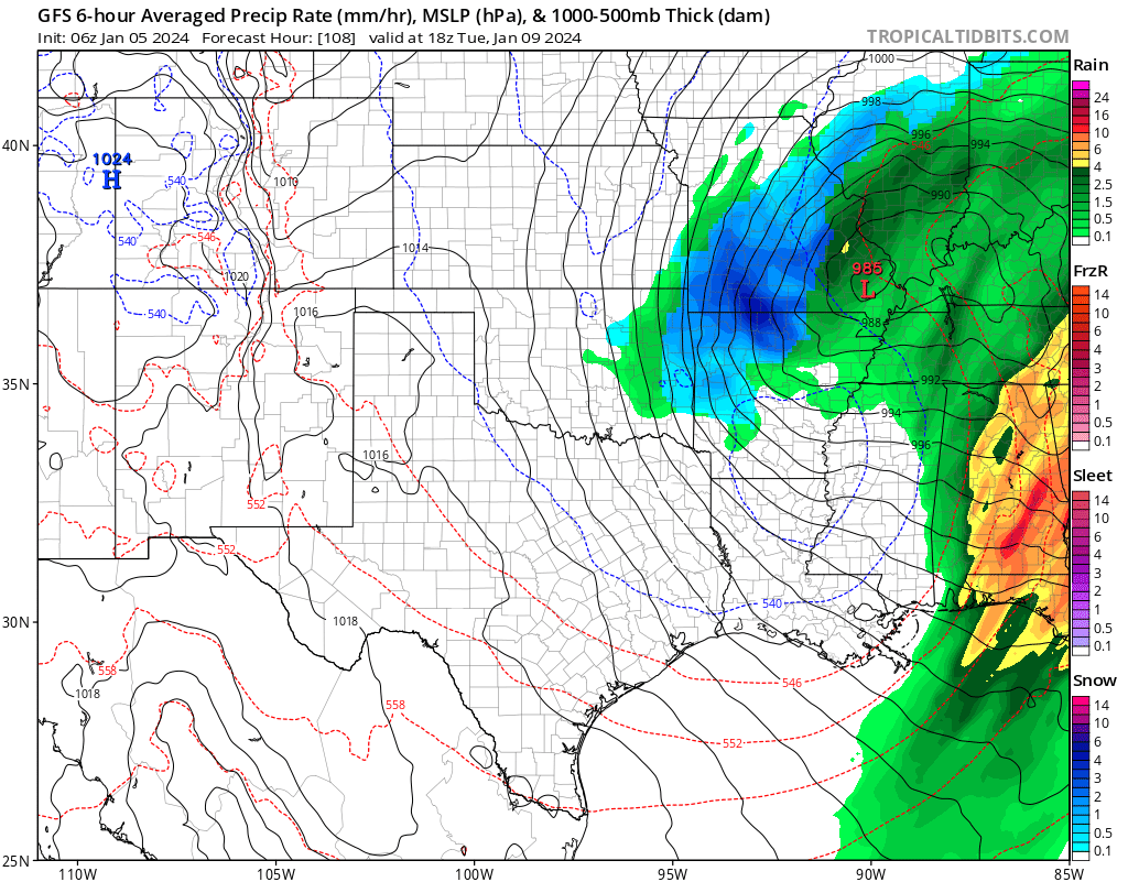
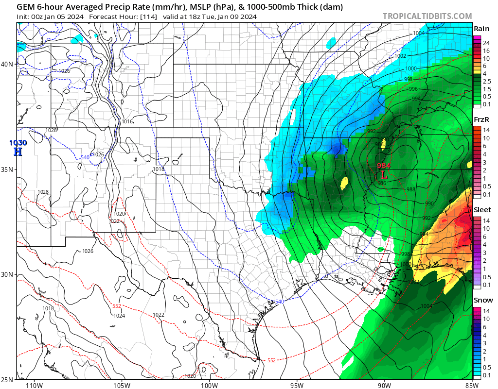
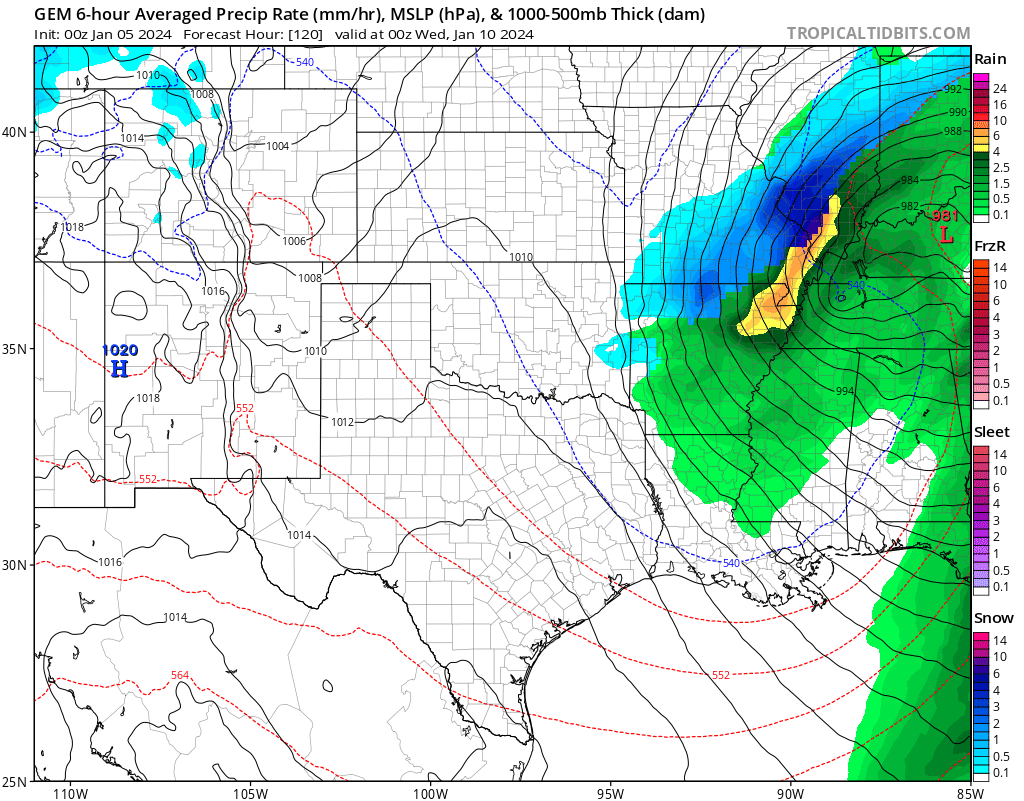
Our next system is a doozey. This is what the GFS and Canadian models show. Check out the widespread precipitation centered around the deep area of low pressure. It has been a while since we have seen a storm like this.
Green is rain. Yellow and orange are moderate to heavy rain. Blue is snow. Dark blue is heavier snow.
This is the first wave of precip Monday afternoon and evening.
Then a second wave Monday night into Tuesday.
Here is the Canadian model. It has the low are bit farther southeast. Thus, the rain snow line is farther southeast. We will need to watch this.
Showers will develop Monday and increase in coverage Monday afternoon and night. Rain will continue into Tuesday and Tuesday night.
A few thunderstorms will be possible from the Missouri Bootheel into Kentucky and Tennessee.
Now, the next big question is snow. This is going to be a difficult forecast and we are still five days out.
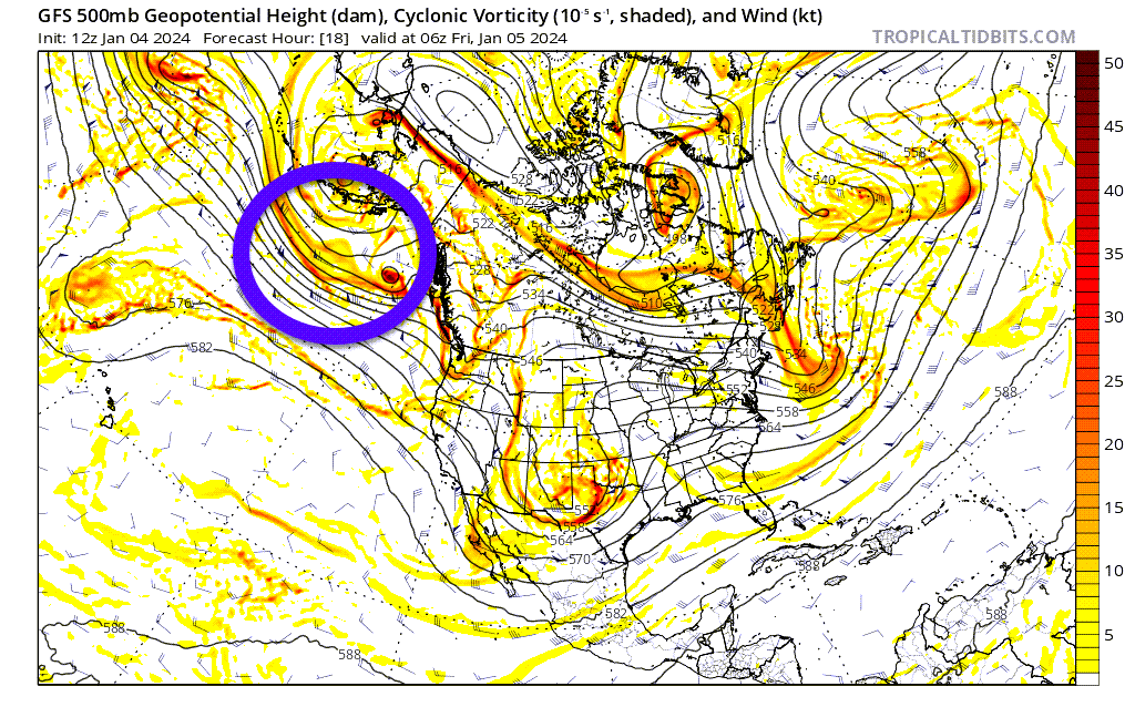
The system in question is still out over the Pacific Ocean. We have still have several days to fine tune the forecast.
Models continue to struggle with where to take the center of low pressure.
The track of the low is key to our weather forecast. Even a shift of 50 to 100 miles will completely change the forecast for some counties.
If you want rain, then you want the low to push to your northwest. If you want snow, then you want the low farther south and east.
At this time, it appears the higher snow chances will end up over portions of Missouri and Illinois. The question is how far south and east. That will depend on the track of the area of low pressure. I will know a lot more tonight and tomorrow.
The rain/snow line may end up across eastern Missouri and southern Illinois. Especially towards the end of the event.
There will likely be a sharp cutoff between where rain occurs and where snow occurs. Although, as the colder air sweeps into the region, behind the low, many areas could briefly change to snow before precipitation ends.
Snow accumulation can’t be ruled out with this system. The highest chance of that, in my area, would be across portions of southeast Missouri and southern Illinois.
A deepening low will track across our region. Model guidance has been showing an area of low pressure ranging from 972 mb to 982 mb. Nearing record low levels for barometric pressure in our local area.
Deep lows do strange things. They tend to produce surprises when it comes to snow accumulation and placement.
Temperatures will be marginal for snow accumulation. The amount of snow that falls will likely depend on the snow rate and timing. If it occurs at night, then chances for accumulation will increase.
I am watching Butler County, Missouri northeast to Bollinger County, Missouri and then northeast towards Jefferson County, Illinois. Along and northwest of that line has a higher chance of snow vs areas south and east.
Again, all of this is HIGHLY dependent on where that low tracks. I will be closely monitoring the data today and tomorrow.
They can also lead to high gradient wind gusts. We are going to have to monitor the risk of 40+ mph winds. That would mainly be Monday afternoon into Wednesday.
We had a system like this last March and it produced widespread 50 to 60 mph winds. Wind gusts of at least 40 mph will be possible with this system. Perhaps higher.
Let me show you a few maps.
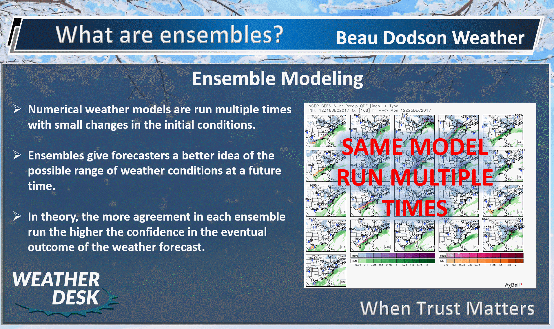
I like to use ensembles when forecasting in the long range.
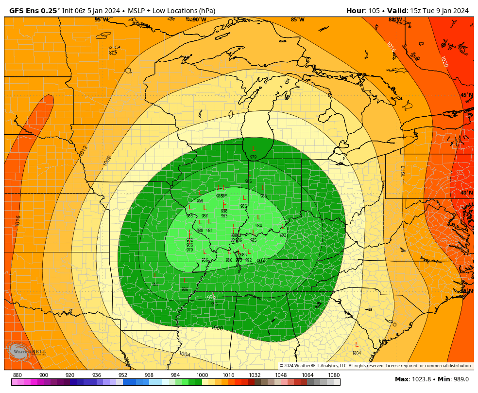
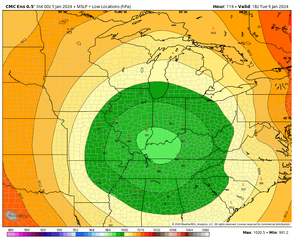
Here is the GFS ensembles showing the track of the area of low pressure. A large number of them are clustered around southern Illinois into southern Indiana.
This would keep the higher snow chances northwest of St Louis. But, close to some of my counties. Again, if the low were to track through Kentucky/Tennessee then you would shift the rain/snow line farther into southeast Missouri and southern Illinois.
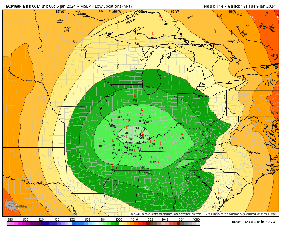
Here is the EC ensembles. They match up fairly well with the EC
And the Canadian ensembles. The Canadian is a tad farther southeast vs the other models.
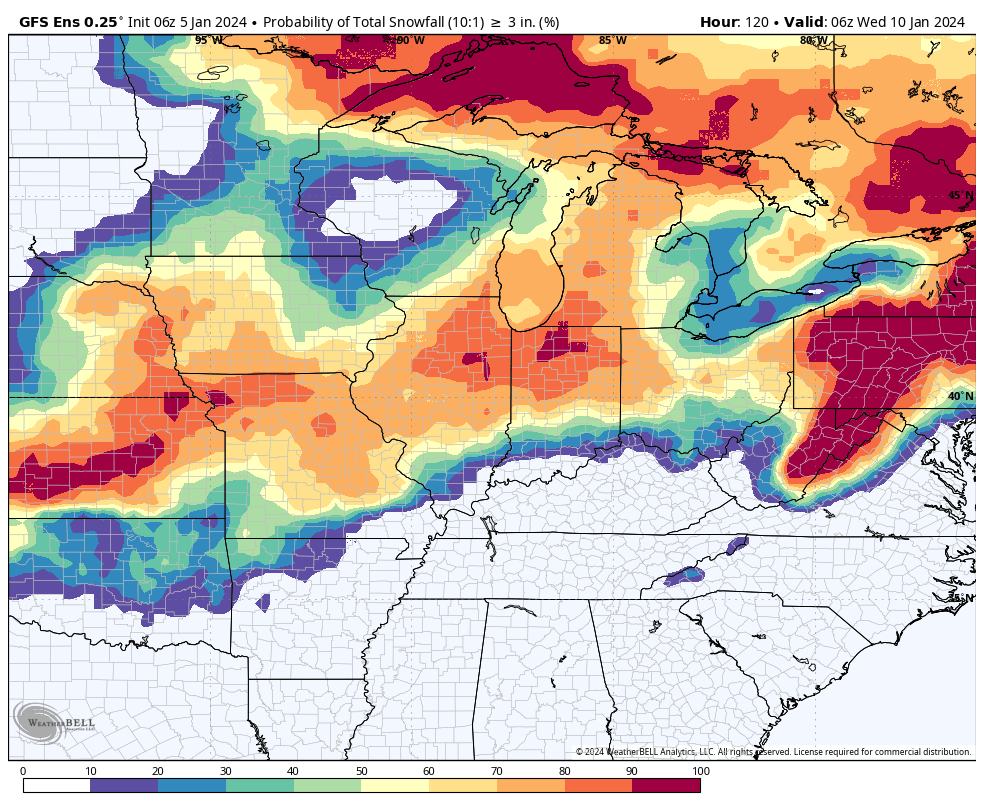
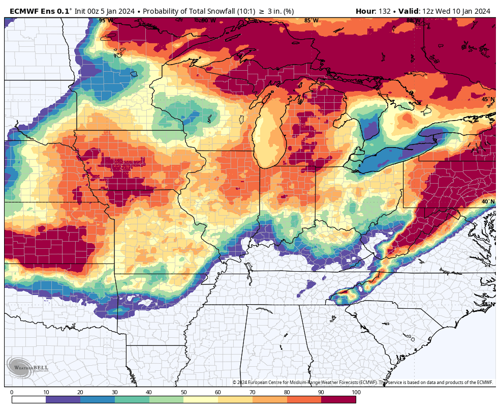
Let’s look at snow probabilities from the ensembles.
What is the probability of 3 inches of snow?
GFS model
EC model
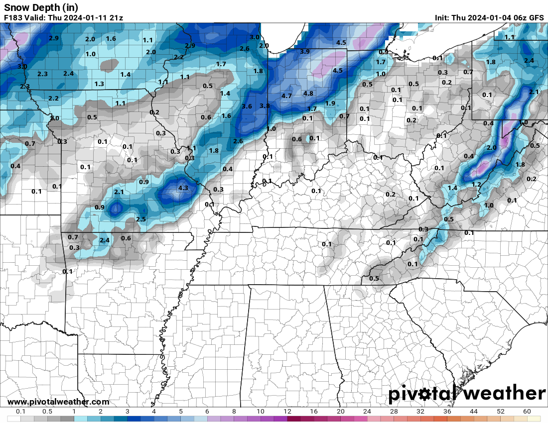
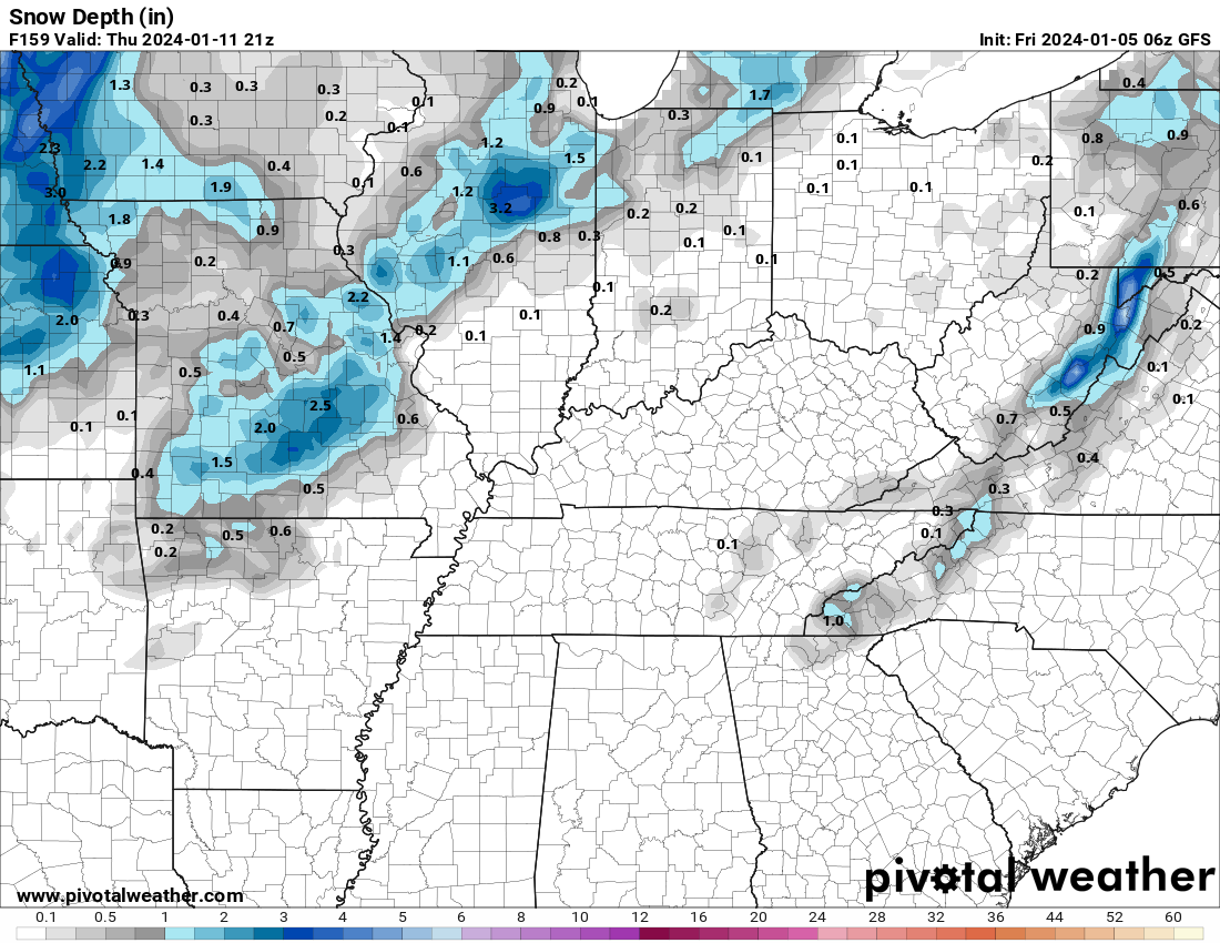
The model run from 24 hours ago showed this for snow depth.
This morning’s run showed this
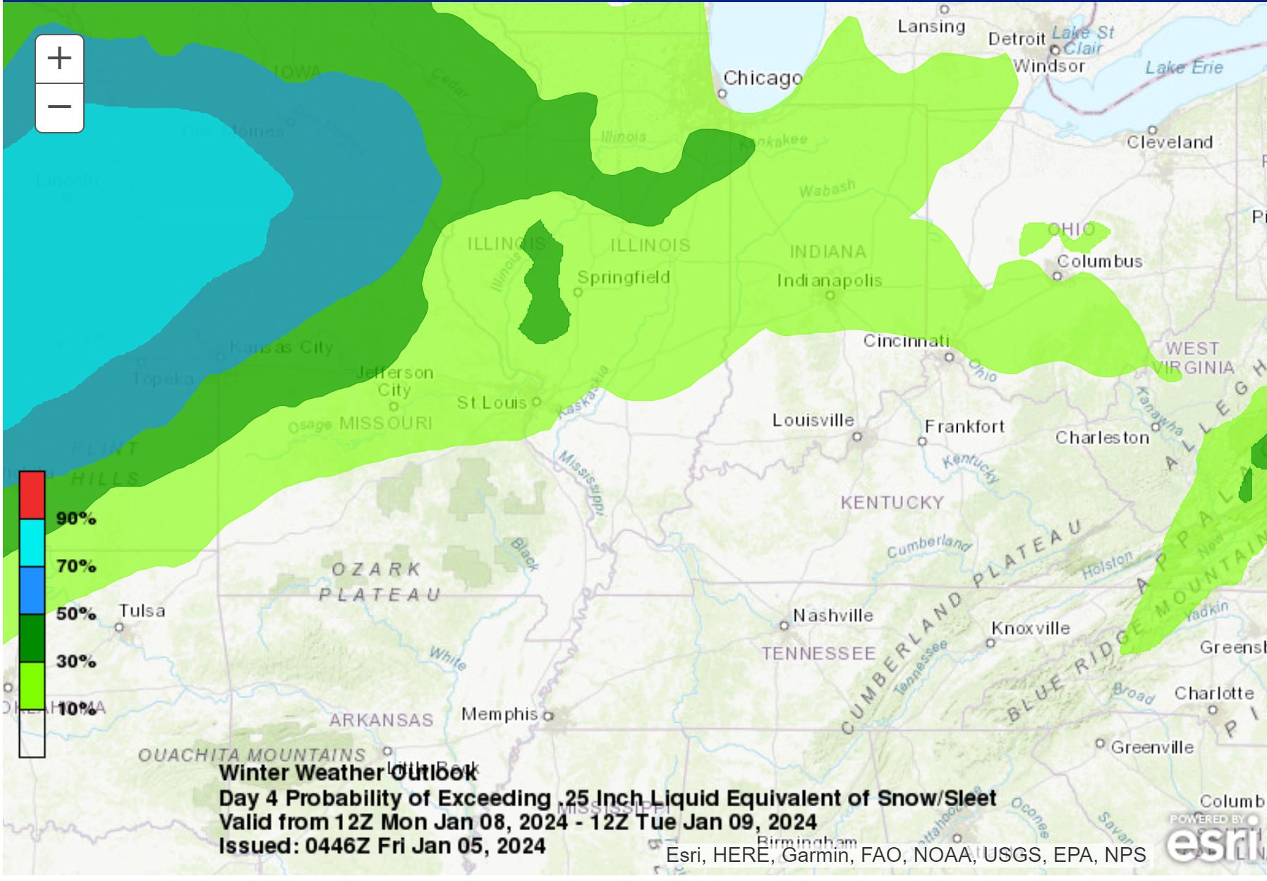
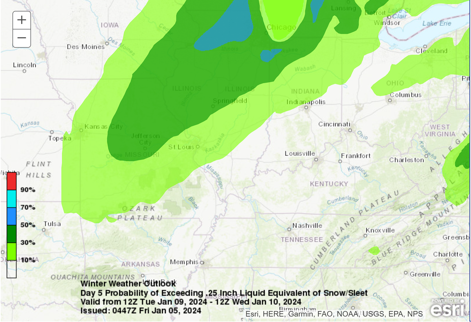
Here is the latest WPC snowfall outlook. What is the probability of 0.25″ or more of melted precipitation occurring Monday and Tuesday?
0.25″ of melted precipitation would be 2 to 3 inches of snow.
At this time, the risk is higher north northwest of my forecast counties (Monday/Monday night).
Tuesdays/Wednesday.
As always, during the winter months, check back for updates. Don’t walk away with one forecast and think it won’t change. We do well in the day one through three time-frame. During an active pattern it becomes increasingly complicated as we move into day four, five, six, and seven.
.
Click here if you would like to return to the top of the page.
This outlook covers southeast Missouri, southern Illinois, western Kentucky, and far northwest Tennessee.
.
Today’s Storm Prediction Center’s Severe Weather Outlook
Light green is where thunderstorms may occur but should be below severe levels.
Dark green is a level one risk. Yellow is a level two risk. Orange is a level three (enhanced) risk. Red is a level four (moderate) risk. Pink is a level five (high) risk.
One is the lowest risk. Five is the highest risk.
A severe storm is one that produces 58 mph wind or higher, quarter size hail, and/or a tornado.
Explanation of tables. Click here.

.
Tornado Probability Outlook

.
Large Hail Probability Outlook

.
High wind Probability Outlook

.
Tomorrow’s severe weather outlook.

.
Day Three Severe Weather Outlook

.

.
The images below are from NOAA’s Weather Prediction Center.
24-hour precipitation outlook..
 .
.
.
48-hour precipitation outlook.
. .
.
![]()
_______________________________________
.

Click here if you would like to return to the top of the page.
Again, as a reminder, these are models. They are never 100% accurate. Take the general idea from them.
What should I take from these?
- The general idea and not specifics. Models usually do well with the generalities.
- The time-stamp is located in the upper left corner.
.
What am I looking at?
You are looking at computer model data. Meteorologists use many different models to forecast the weather.
Occasionally, these maps are in Zulu time. 12z=7 AM. 18z=1 PM. 00z=7 PM. 06z=1 AM
Green represents light rain. Dark green represents moderate rain. Yellow and orange represent heavier rain.
.
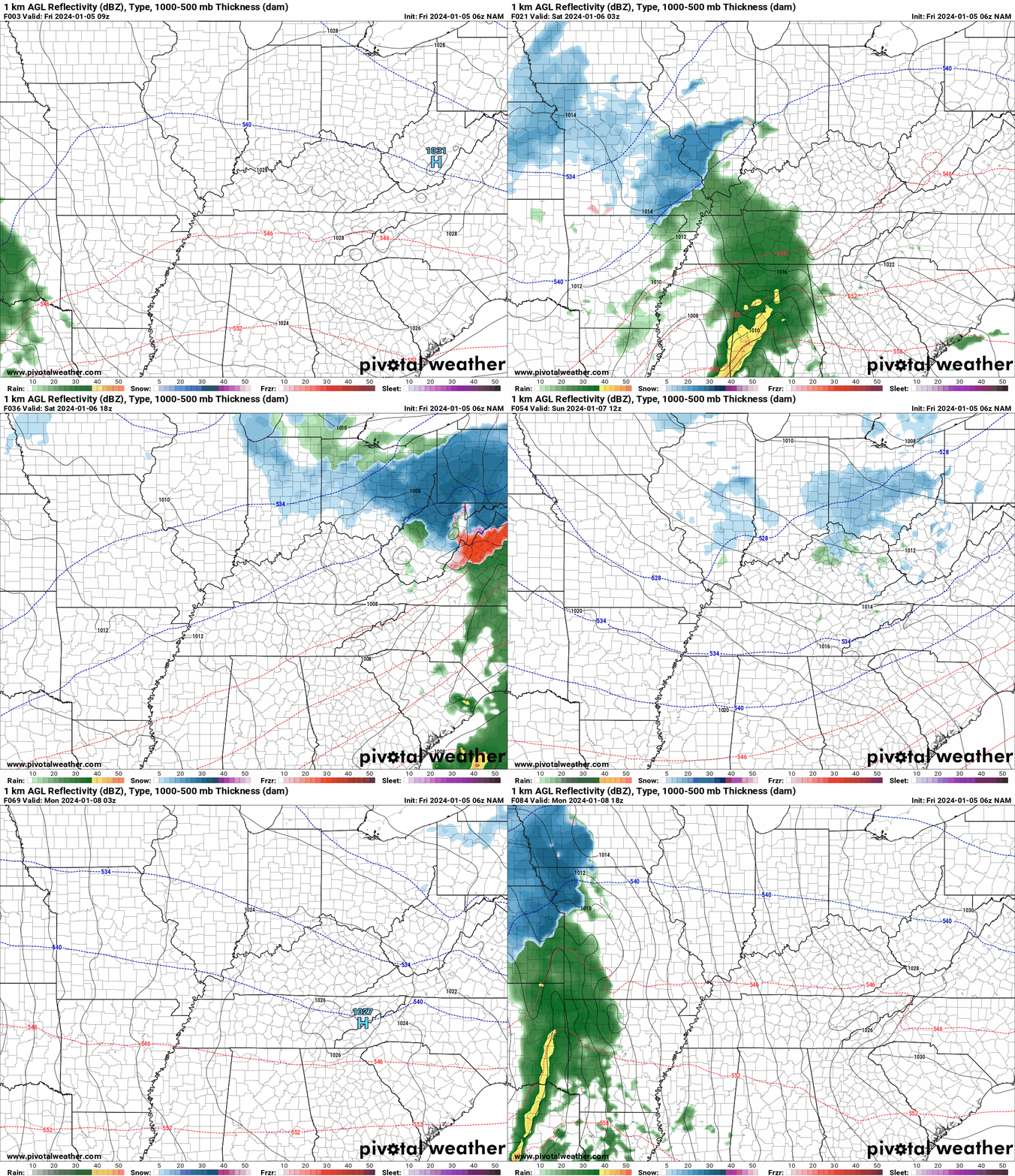
This animation is the NAM Model.
Green is rain. Yellow and orange are heavier rain. Pink is a wintry mix. Blue is snow. Dark blue is heavier snow.
Occasionally, these maps are in Zulu time. 12z=6 AM. 18z=12 PM. 00z=6 PM. 06z=12 AM
Double click images to enlarge them.
.
This animation is the Hrrr Model.
Green is rain. Yellow and orange are heavier rain. Pink is a wintry mix. Blue is snow. Dark blue is heavier snow.
Occasionally, these maps are in Zulu time. 12z=6 AM. 18z=12 PM. 00z=6 PM. 06z=12 AM
Double click images to enlarge them.
.
This animation is the GFS Model.
Green is rain. Yellow and orange are heavier rain. Pink is a wintry mix. Blue is snow. Dark blue is heavier snow.
Occasionally, these maps are in Zulu time. 12z=6 AM. 18z=12 PM. 00z=6 PM. 06z=12 AM
Double click images to enlarge them.
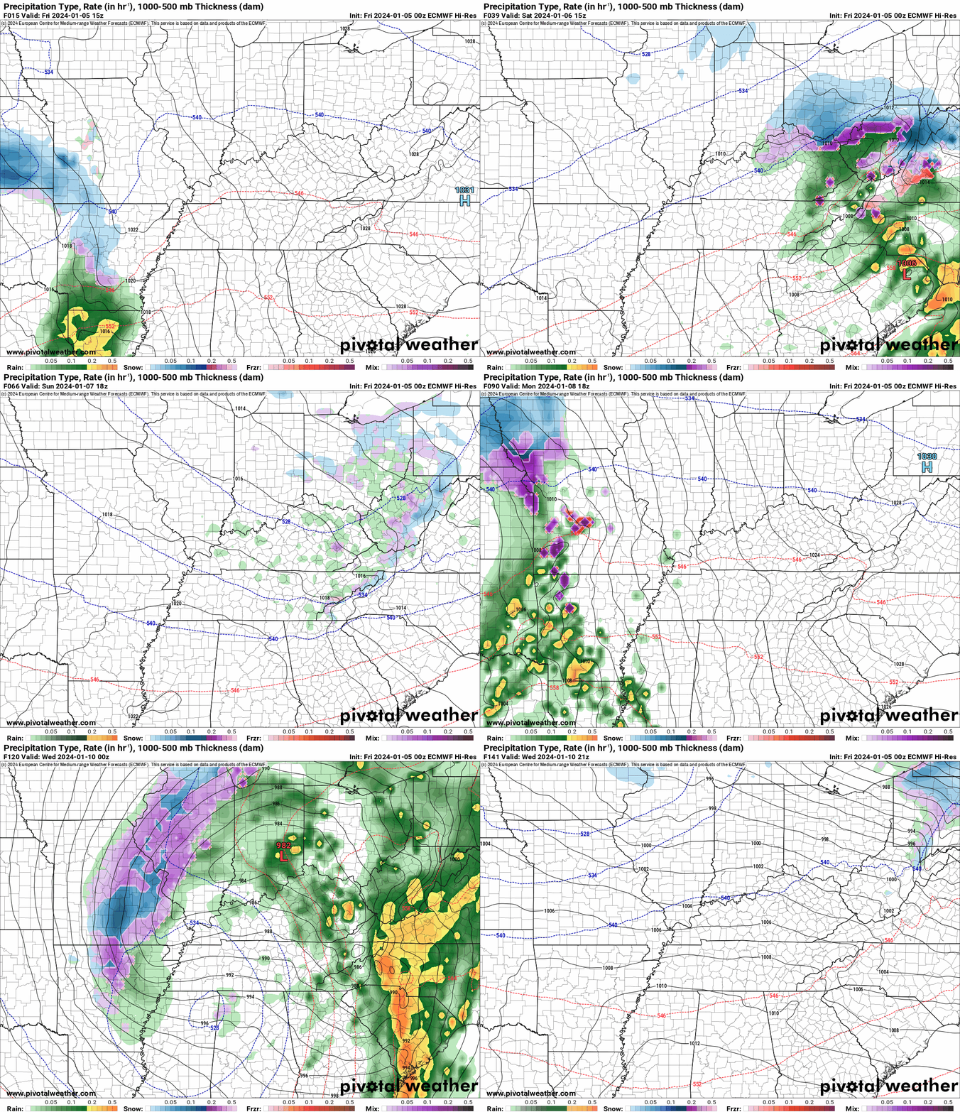
This animation is the EC Model.
Green is rain. Yellow and orange are heavier rain. Pink is a wintry mix. Blue is snow. Dark blue is heavier snow.
Occasionally, these maps are in Zulu time. 12z=6 AM. 18z=12 PM. 00z=6 PM. 06z=12 AM
Double click images to enlarge them.
..![]()

.
Click here if you would like to return to the top of the page.
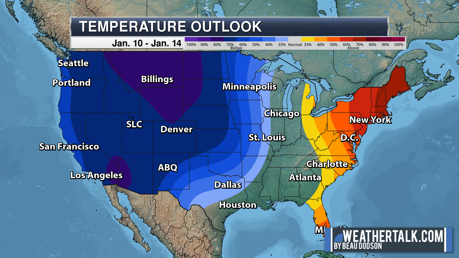
.Average high temperatures for this time of the year are around 45 degrees.
Average low temperatures for this time of the year are around 28 degrees.
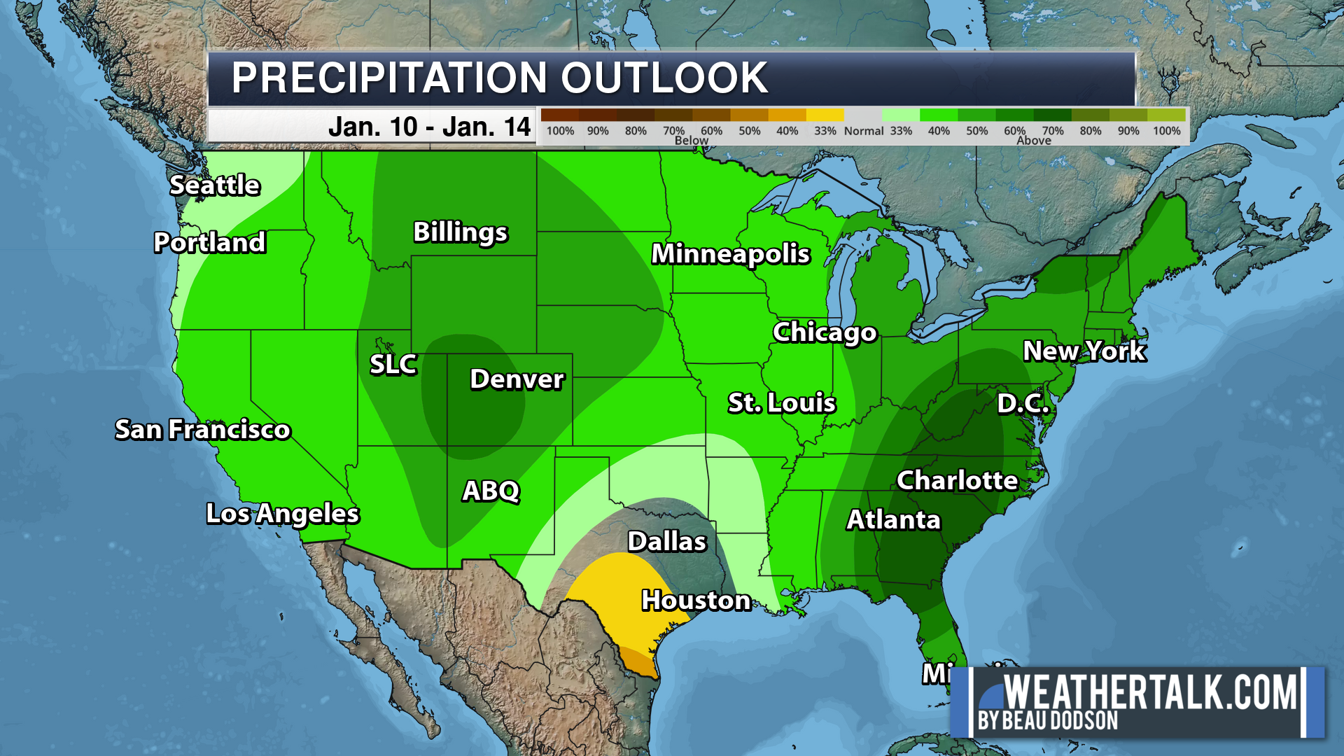
Average precipitation during this time period ranges from 0.50″ to 1.00″
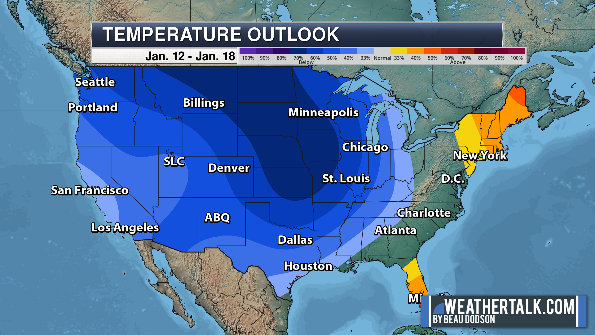
Six to Ten Day Outlook.
Blue is below average. Red is above average. The no color zone represents equal chances.
Average highs for this time of the year are in the lower 60s. Average lows for this time of the year are in the lower 40s.
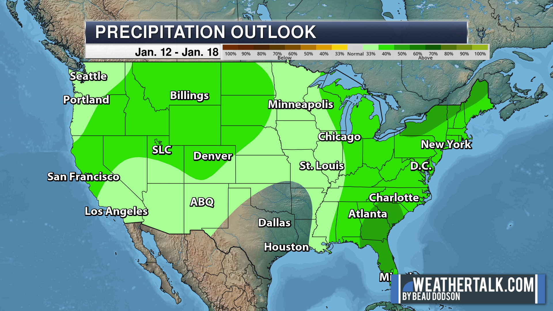
Green is above average precipitation. Yellow and brown favors below average precipitation. Average precipitation for this time of the year is around one inch per week.
.

Average low temperatures for this time of the year are around 28 degrees.
Average precipitation during this time period ranges from 0.50″ to 1.00″
.
.
![]()
The app is for subscribers. Subscribe at www.weathertalk.com/welcome then go to your app store and search for WeatherTalk
Subscribers, PLEASE USE THE APP. ATT and Verizon are not reliable during severe weather. They are delaying text messages.
The app is under WeatherTalk in the app store.
Apple users click here
Android users click here
.

Radars and Lightning Data
Interactive-city-view radars. Clickable watches and warnings.
https://wtalk.co/B3XHASFZ
If the radar is not updating then try another one. If a radar does not appear to be refreshing then hit Ctrl F5. You may also try restarting your browser.
Backup radar site in case the above one is not working.
https://weathertalk.com/morani
Regional Radar
https://imagery.weathertalk.com/prx/RadarLoop.mp4
** NEW ** Zoom radar with chaser tracking abilities!
ZoomRadar
Lightning Data (zoom in and out of your local area)
https://wtalk.co/WJ3SN5UZ
Not working? Email me at beaudodson@usawx.com
National map of weather watches and warnings. Click here.
Storm Prediction Center. Click here.
Weather Prediction Center. Click here.
.

Live lightning data: Click here.
Real time lightning data (another one) https://map.blitzortung.org/#5.02/37.95/-86.99
Our new Zoom radar with storm chases
.
.

Interactive GOES R satellite. Track clouds. Click here.
GOES 16 slider tool. Click here.
College of DuPage satellites. Click here
.

Here are the latest local river stage forecast numbers Click Here.
Here are the latest lake stage forecast numbers for Kentucky Lake and Lake Barkley Click Here.
.
.
Find Beau on Facebook! Click the banner.









 .
.