
Click one of the links below to take you directly to that section
Do you have any suggestions or comments? Email me at beaudodson@usawx.com
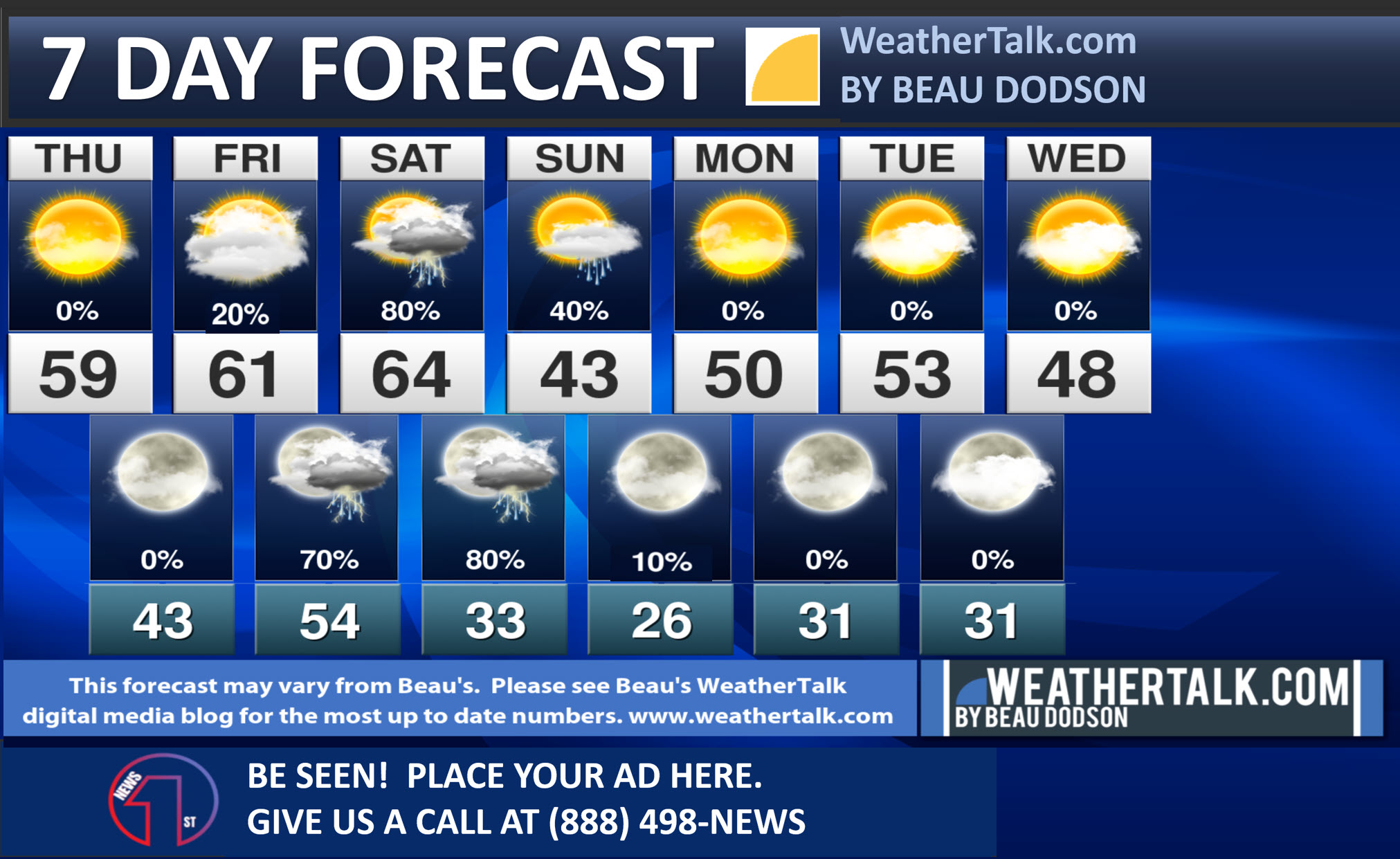
Seven-day forecast for southeast Missouri, southern Illinois, western Kentucky, and western Tennessee.
This is a BLEND for the region. Scroll down to see the region by region forecast.
THE FORECAST IS GOING TO VARY FROM LOCATION TO LOCATION. Scroll down to see the region by region forecast.
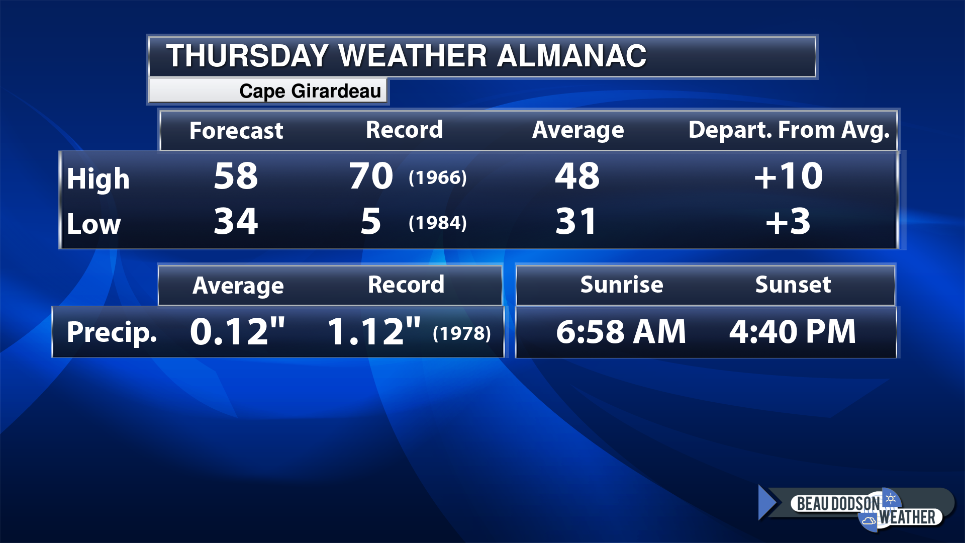
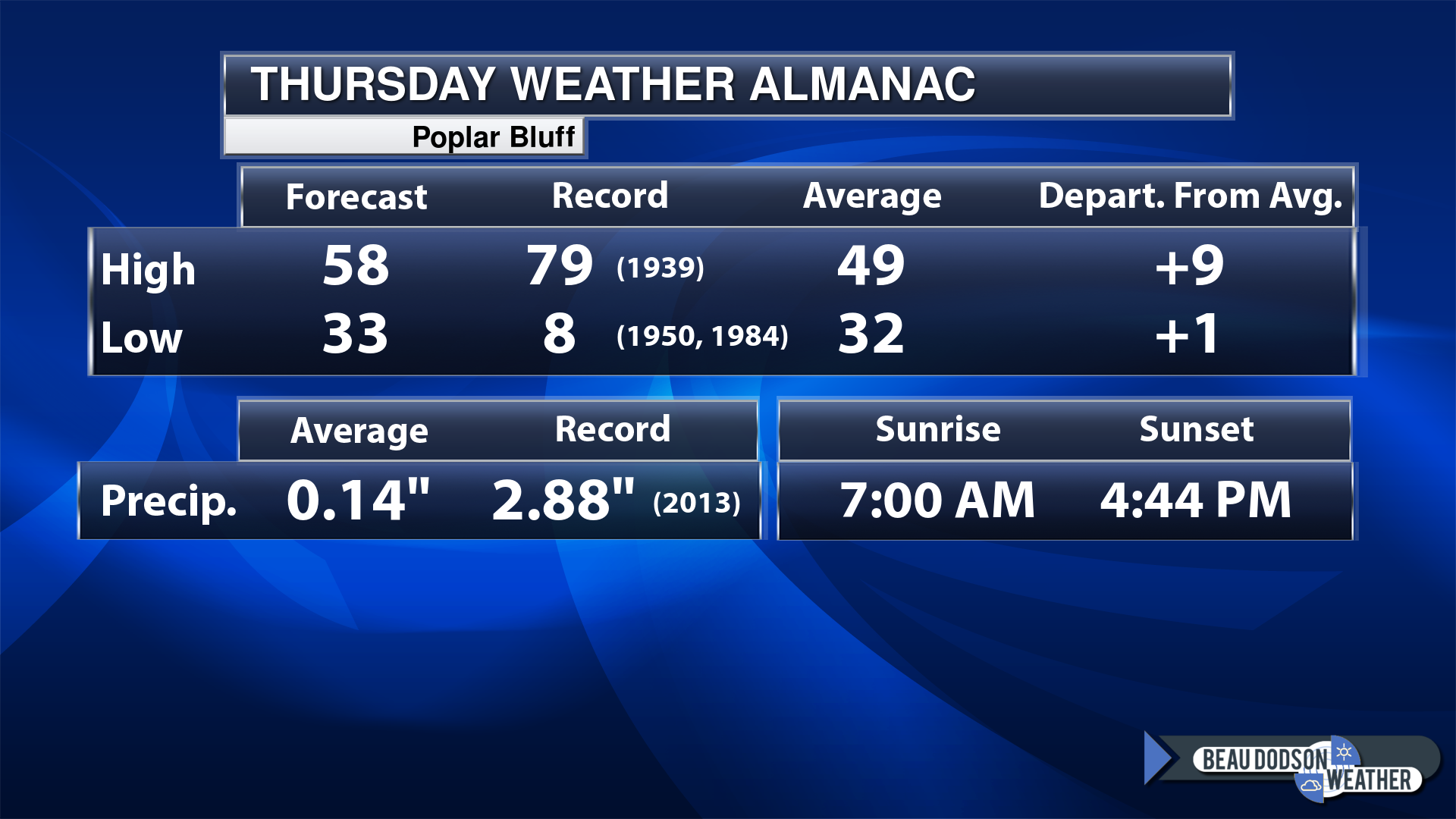
Today’s Local Almanacs (for a few select cities). Your location will be comparable.
Note, the low is this morning’s low and not tomorrows.
Today’s almanac numbers from a few select local cities.
The forecast temperature shows you today’s expected high and this morning’s low.
The graphic shows you the record high and record low for today. It shows you what year that occurred, as well.
It then shows you what today’s average temperature is.
Then, it shows you the departures (how may degrees above or below average temperatures will be ).
It shows you the average precipitation for today. Average comes from thirty years of rain totals.
It also shows you the record rainfall for the date and what year that occurred.
The sunrise and sunset are also shown.
If you have not subscribed to my YouTube Channel then click on this link and it will take you to my videos.
Click the button below and it will take you to the Beau Dodson YouTube Channel.
48-hour forecast


.

.
Thursday to Thursday
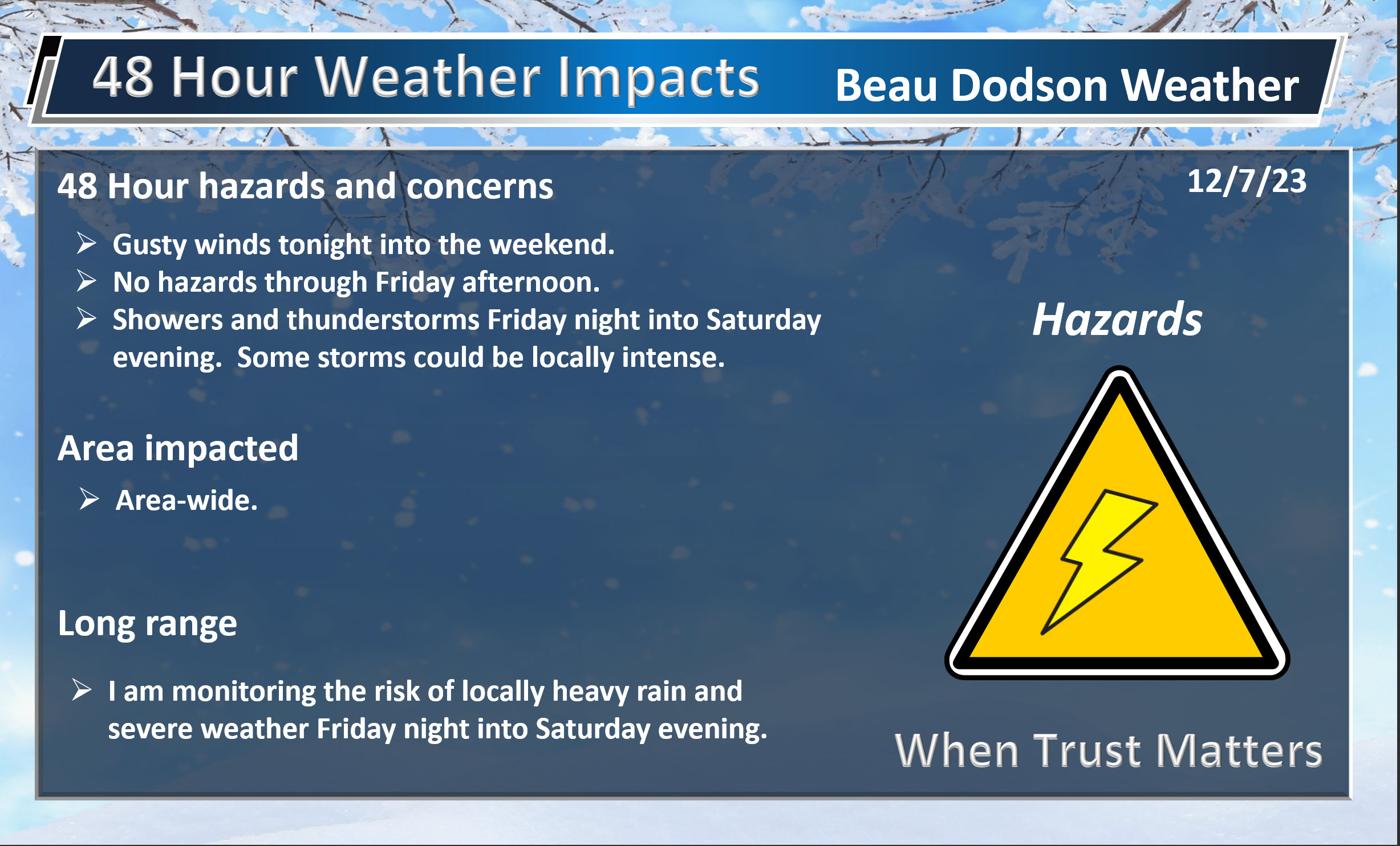
1. Is lightning in the forecast? Yes. Lightning is likely Friday night into Saturday. Perhaps into Saturday night.
2. Are severe thunderstorms in the forecast? Yes. Severe weather is possible Saturday. At this time, it appears to be a low level damaging wind and tornado threat. Monitor updates.
3. Is flash flooding in the forecast? Unlikely. Locally heavy rain is possible Friday night into Saturday night. I can’t rule out some issues in commonly flooded locations. Esp if leaves are blocking drains. Widespread flash flooding is not expected.
4. Will the heat index exceed 100 degrees? No.
5. Will the wind chill dip below 10 degrees? No.
6. Is measurable snow and/or sleet in the forecast? Not at this time. Monitor updates concerning a weekend storm system. A few models show snow and ice. Chances appear limited, for now. I am watching it, as well.
7. Is freezing rain/ice in the forecast? Not at this time. Monitor updates concerning a weekend storm system. A few models show snow and ice. Chances appear limited, for now. I am watching it, as well.
Freezing rain is rain that falls and instantly freezes on objects such as trees and power lines
.
Fire weather risk level.
Thursday: 4. Low risk.
Thursday night: 4. Low risk.
Friday: 4. Low risk.
Friday night: 4. Low risk.
Fire Weather Discussion
Breezy and warmer conditions can be expected through Saturday. A storm system will bring rain and some thunderstorms to our region Friday night through early Sunday. It will be much cooler Sunday, then a warm up will begin Monday.
A Haines Index of 6 means a high potential for an existing fire to become large or exhibit erratic fire behavior, 5 means medium potential, 4 means low potential, and anything less than 4 means very low potential.
.
.
Thursday, December 7, 2023
Confidence in the forecast? High Confidence
Thursday Forecast: Mostly sunny.
What is the chance of precipitation?
Far northern southeast Missouri ~ 0%
Southeast Missouri ~ 0%
The Missouri Bootheel ~ 0%
I-64 Corridor of southern Illinois ~ 0%
Southern Illinois ~ 0%
Extreme southern Illinois (southern seven counties) ~ 0%
Far western Kentucky (Purchase area) ~ 0%
The Pennyrile area of western KY ~ 0%
Northwest Kentucky (near Indiana border) ~ 0%
Northwest Tennessee ~ 0%
Coverage of precipitation:
Timing of the precipitation:
Far northern southeast Missouri ~ 58° to 62°
Southeast Missouri ~ 58° to 62°
The Missouri Bootheel ~ 58° to 62°
I-64 Corridor of southern Illinois ~ 56° to 60°
Southern Illinois ~ 56° to 60°
Extreme southern Illinois (southern seven counties) ~ 56° to 60°
Far western Kentucky ~ 56° to 60°
The Pennyrile area of western KY ~ 56° to 60°
Northwest Kentucky (near Indiana border) ~ 56° to 60°
Northwest Tennessee ~ 58° to 62°
Winds will be from this direction: South southwest 10 to 25 mph. Gusty.
Wind chill or heat index (feels like) temperature forecast: 54° to 60°
What impacts are anticipated from the weather?
Should I cancel my outdoor plans? No
UV Index: 2. Low.
Sunrise: 6:55 AM
Sunset: 4:37 PM
.
Thursday Night Forecast: Mostly clear. Windy.
What is the chance of precipitation?
Far northern southeast Missouri ~ 0%
Southeast Missouri ~ 0%
The Missouri Bootheel ~ 0%
I-64 Corridor of southern Illinois ~ 0%
Southern Illinois ~ 0%
Extreme southern Illinois (southern seven counties) ~ 0%
Far western Kentucky (Purchase area) ~ 0%
The Pennyrile area of western KY ~ 0%
Northwest Kentucky (near Indiana border) ~ 0%
Northwest Tennessee ~ 0%
Coverage of precipitation:
Timing of the precipitation:
Temperature range:
Far northern southeast Missouri ~ 42° to 45°
Southeast Missouri ~ 42° to 45°
The Missouri Bootheel ~ 42° to 45°
I-64 Corridor of southern Illinois ~ 42° to 45°
Southern Illinois ~ 42° to 45°
Extreme southern Illinois (southern seven counties) ~ 42° to 45°
Far western Kentucky ~ 42° to 45°
The Pennyrile area of western KY ~ 42° to 45°
Northwest Kentucky (near Indiana border) ~ 42° to 45°
Northwest Tennessee ~ 42° to 45°
Winds will be from this direction: South 15 to 30 mph. Gusty.
Wind chill or heat index (feels like) temperature forecast: 42° to 45°
What impacts are anticipated from the weather?
Should I cancel my outdoor plans? No
Moonrise: 1:27 AM
Moonset: 1:26 PM
The phase of the moon: Waning Crescent
.
Friday, December 8, 2023
Confidence in the forecast? High Confidence
Friday Forecast: Mostly sunny during the morning. Increasing afternoon clouds. A slight chance of a shower. Milder. Windy.
What is the chance of precipitation?
Far northern southeast Missouri ~ 20%
Southeast Missouri ~ 20%
The Missouri Bootheel ~ 20%
I-64 Corridor of southern Illinois ~ 20%
Southern Illinois ~ 20%
Extreme southern Illinois (southern seven counties) ~ 20%
Far western Kentucky (Purchase area) ~ 20%
The Pennyrile area of western KY ~ 20%
Northwest Kentucky (near Indiana border) ~ 20%
Northwest Tennessee ~ 20%
Coverage of precipitation: Widely scattered
Timing of the precipitation: After 1 PM
Far northern southeast Missouri ~ 60° to 62°
Southeast Missouri ~ 60° to 62°
The Missouri Bootheel ~ 60° to 62°
I-64 Corridor of southern Illinois ~ 60° to 62°
Southern Illinois ~ 60° to 62°
Extreme southern Illinois (southern seven counties) ~ 60° to 62°
Far western Kentucky ~ 60° to 62°
The Pennyrile area of western KY ~ 60° to 62°
Northwest Kentucky (near Indiana border) ~ 60° to 62°
Northwest Tennessee ~ 60° to 62°
Winds will be from this direction: South southwest 15 to 30 mph. Gusty.
Wind chill or heat index (feels like) temperature forecast: 58° to 62°
What impacts are anticipated from the weather?
Should I cancel my outdoor plans? No
UV Index: 2. Low.
Sunrise: 6:56 AM
Sunset: 4:37 PM
.
Friday Night Forecast: Increasing clouds. Showers and thunderstorms likely.
What is the chance of precipitation?
Far northern southeast Missouri ~ 70%
Southeast Missouri ~ 80%
The Missouri Bootheel ~ 80%
I-64 Corridor of southern Illinois ~ 70%
Southern Illinois ~ 70%
Extreme southern Illinois (southern seven counties) ~ 70%
Far western Kentucky (Purchase area) ~ 70%
The Pennyrile area of western KY ~ 70%
Northwest Kentucky (near Indiana border) ~ 70%
Northwest Tennessee ~ 80%
Coverage of precipitation: Numerous
Timing of the precipitation: Any given point of time
Temperature range:
Far northern southeast Missouri ~ 46° to 50°
Southeast Missouri ~ 46° to 50°
The Missouri Bootheel ~ 46° to 50°
I-64 Corridor of southern Illinois ~ 46° to 50°
Southern Illinois ~ 46° to 52°
Extreme southern Illinois (southern seven counties) ~ 48° to 52°
Far western Kentucky ~ 48° to 52°
The Pennyrile area of western KY ~ 48° to 52°
Northwest Kentucky (near Indiana border) ~ 46° to 50°
Northwest Tennessee ~ 46° to 52°
Winds will be from this direction: South 15 to 25 mph. Gusty.
Wind chill or heat index (feels like) temperature forecast: 46° to 50°
What impacts are anticipated from the weather?
Should I cancel my outdoor plans? No
Moonrise: 2:25 AM
Moonset: 1:49 PM
The phase of the moon: Waning Crescent
.
Saturday, December 9, 2023
Confidence in the forecast? High Confidence
Saturday Forecast: Mostly cloudy. A chance of showers and thunderstorms. Turning colder northwest to southeast as the day wears on.
What is the chance of precipitation?
Far northern southeast Missouri ~ 80%
Southeast Missouri ~ 80%
The Missouri Bootheel ~ 80%
I-64 Corridor of southern Illinois ~ 80%
Southern Illinois ~ 80%
Extreme southern Illinois (southern seven counties) ~ 80%
Far western Kentucky (Purchase area) ~ 80%
The Pennyrile area of western KY ~ 80%
Northwest Kentucky (near Indiana border) ~ 80%
Northwest Tennessee ~ 80%
Coverage of precipitation: Widespread
Timing of the precipitation: Any given point of time
Far northern southeast Missouri ~ 60° to 62°
Southeast Missouri ~ 60° to 62°
The Missouri Bootheel ~ 60° to 62°
I-64 Corridor of southern Illinois ~ 60° to 62°
Southern Illinois ~ 60° to 62°
Extreme southern Illinois (southern seven counties) ~ 60° to 62°
Far western Kentucky ~ 60° to 62°
The Pennyrile area of western KY ~ 60° to 62°
Northwest Kentucky (near Indiana border) ~ 60° to 62°
Northwest Tennessee ~ 60° to 62°
Winds will be from this direction: South southwest becoming west northwest 10 to 20 mph with higher gusts.
Wind chill or heat index (feels like) temperature forecast: 50° to 60°
What impacts are anticipated from the weather? Wet roadways. Lightning.
Should I cancel my outdoor plans? Have a plan B and monitor the Beau Dodson Weather Radars.
UV Index: 2. Low.
Sunrise: 6:57 AM
Sunset: 4:37 PM
.
Saturday Night Forecast: Mostly cloudy. A chance of showers. Perhaps some evening thunderstorms. Turning colder. Windy.
What is the chance of precipitation?
Far northern southeast Missouri ~ 60%
Southeast Missouri ~ 60%
The Missouri Bootheel ~ 60%
I-64 Corridor of southern Illinois ~ 60%
Southern Illinois ~ 70%
Extreme southern Illinois (southern seven counties) ~ 70%
Far western Kentucky (Purchase area) ~ 70%
The Pennyrile area of western KY ~ 70%
Northwest Kentucky (near Indiana border) ~ 70%
Northwest Tennessee ~ 70%
Coverage of precipitation: Numerous
Timing of the precipitation: Mostly before midnight. Some scattered activity after midnight.
Temperature range:
Far northern southeast Missouri ~ 30° to 34°
Southeast Missouri ~ 32° to 34°
The Missouri Bootheel ~ 33° to 36°
I-64 Corridor of southern Illinois ~ 30° to 34°
Southern Illinois ~ 32° to 34°
Extreme southern Illinois (southern seven counties) ~ 32° to 34°
Far western Kentucky ~ 32° to 34°
The Pennyrile area of western KY ~ 34° to 36°
Northwest Kentucky (near Indiana border) ~ 32° to 34°
Northwest Tennessee ~ 34° to 36°
Winds will be from this direction: West northwest 15 to 30 mph. Gusty.
Wind chill or heat index (feels like) temperature forecast: 20° to 30°
What impacts are anticipated from the weather? Wet roadways. Lightning.
Should I cancel my outdoor plans? Have a plan B and monitor updates.
Moonrise: 3:28 AM
Moonset: 2:15 PM
The phase of the moon: Waning Crescent
.
Sunday, December 10, 2023
Confidence in the forecast? High Confidence
Sunday Forecast: Partly cloudy. A chance of rain showers. Rain may mix with wet snow. No accumulation.
What is the chance of precipitation?
Far northern southeast Missouri ~ 20%
Southeast Missouri ~ 20%
The Missouri Bootheel ~ 20%
I-64 Corridor of southern Illinois ~ 30%
Southern Illinois ~ 30%
Extreme southern Illinois (southern seven counties) ~ 30%
Far western Kentucky (Purchase area) ~ 30%
The Pennyrile area of western KY ~ 30%
Northwest Kentucky (near Indiana border) ~ 30%
Northwest Tennessee ~ 30%
Coverage of precipitation: Widely scattered
Timing of the precipitation: Any given point of time
Far northern southeast Missouri ~ 40° to 42°
Southeast Missouri ~ 42° to 44°
The Missouri Bootheel ~ 43° to 46°
I-64 Corridor of southern Illinois ~ 40° to 42°
Southern Illinois ~ 42° to 44°
Extreme southern Illinois (southern seven counties) ~ 42° to 44°
Far western Kentucky ~ 42° to 44°
The Pennyrile area of western KY ~ 43° to 46°
Northwest Kentucky (near Indiana border) ~ 42° to 44°
Northwest Tennessee ~ 43° to 46°
Winds will be from this direction: North northwest 10 to 20 mph with higher gusts.
Wind chill or heat index (feels like) temperature forecast: 30° to 40°
What impacts are anticipated from the weather? Wet roadways.
Should I cancel my outdoor plans? No, but check the Beau Dodson Weather Radars.
UV Index: 2. Low.
Sunrise: 6:57 AM
Sunset: 4:37 PM
.
Sunday Night Forecast: Partly cloudy. Colder.
What is the chance of precipitation?
Far northern southeast Missouri ~ 0%
Southeast Missouri ~ 0%
The Missouri Bootheel ~ 0%
I-64 Corridor of southern Illinois ~ 0%
Southern Illinois ~ 0%
Extreme southern Illinois (southern seven counties) ~ 0%
Far western Kentucky (Purchase area) ~ 0%
The Pennyrile area of western KY ~ 0%
Northwest Kentucky (near Indiana border) ~ 0%
Northwest Tennessee ~ 0%
Coverage of precipitation:
Timing of the precipitation:
Temperature range:
Far northern southeast Missouri ~ 22° to 24°
Southeast Missouri ~ 22° to 24°
The Missouri Bootheel ~ 24° to 28°
I-64 Corridor of southern Illinois ~ 22° to 24°
Southern Illinois ~ 22° to 25°
Extreme southern Illinois (southern seven counties) ~ 23° to 26°
Far western Kentucky ~ 23° to 26°
The Pennyrile area of western KY ~ 23° to 26°
Northwest Kentucky (near Indiana border) ~ 23° to 26°
Northwest Tennessee ~ 24° to 28°
Winds will be from this direction: Southwest 7 to 14 mph
Wind chill or heat index (feels like) temperature forecast: 15° to 25°
What impacts are anticipated from the weather?
Should I cancel my outdoor plans? No
Moonrise: 4:32 AM
Moonset: 2:45 PM
The phase of the moon: Waning Crescent
.
Click here if you would like to return to the top of the page.
-
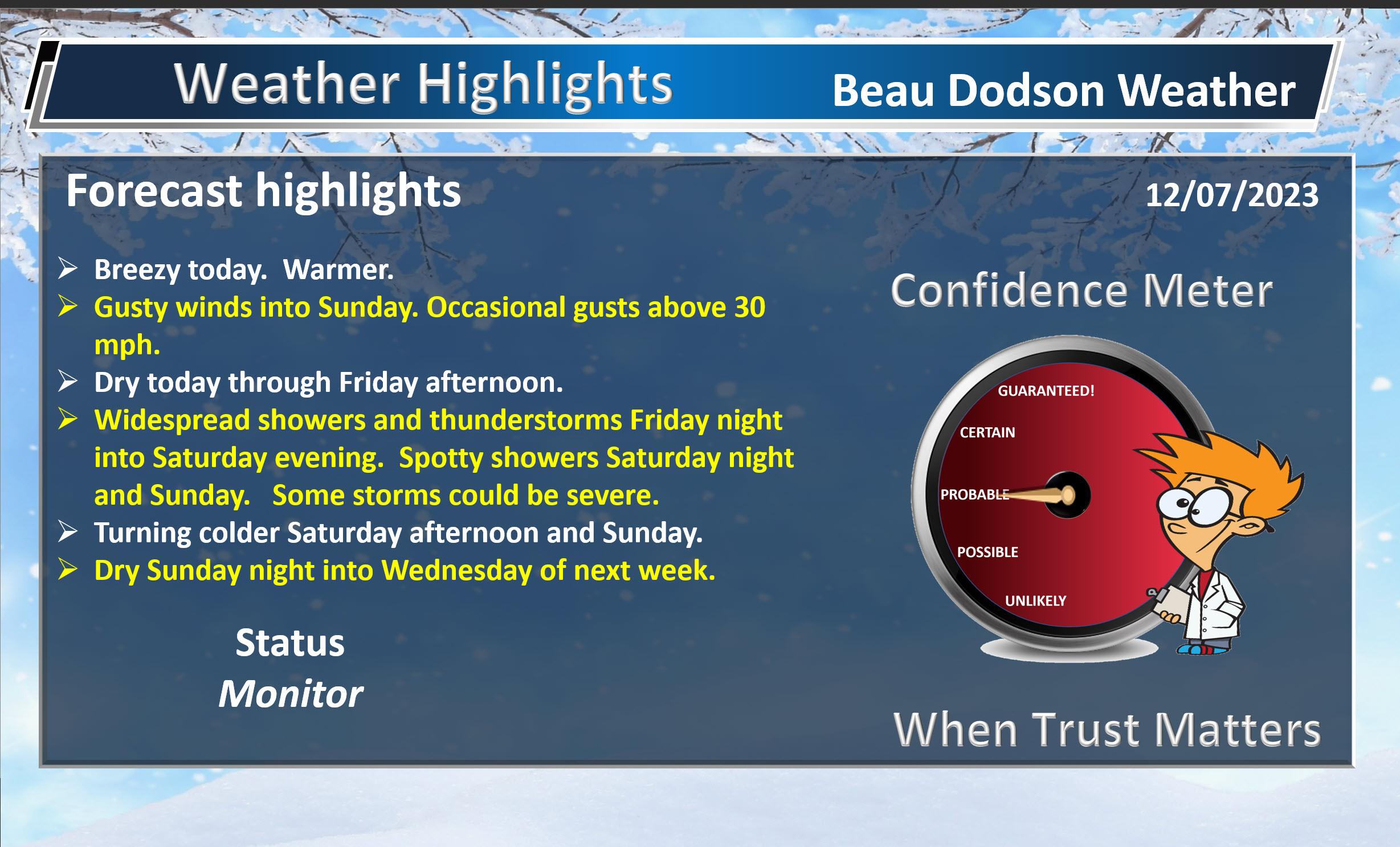
- Breezy conditions into the weekend.
- Slow warming trends.
- Shower and thunderstorm chances this weekend.
Weather advice:
Make sure you have three to five ways of receiving your severe weather information.
.Forecast Discussion
I hope everyone is having a nice week. The weather has been coolish, but nothing extreme.
We will experience a warming trend today. Some good news! It will be windy, at times. Actually, it will be windy into Sunday! Numerous days and nights with winds in the 10 to 20 mph range with occasional 20 to 35 mph gusts. Breezy for those Christmas decorations!
Temperatures into Saturday will climb into the 60s.
All of this is happening in front of a cold front. The front will enter our region Friday night into Saturday night. Working its way west to east.
Warm air will push northward from the Gulf of Mexico. Dew points will rise into the middle to upper 50s, perhaps locally near 60 degrees. That is quite a bit of moisture in December.
There will be a couple of showers Friday afternoon spreading northward from Arkansas and Tennessee. Then, showers and thunderstorms will become numerous Friday night into Saturday.
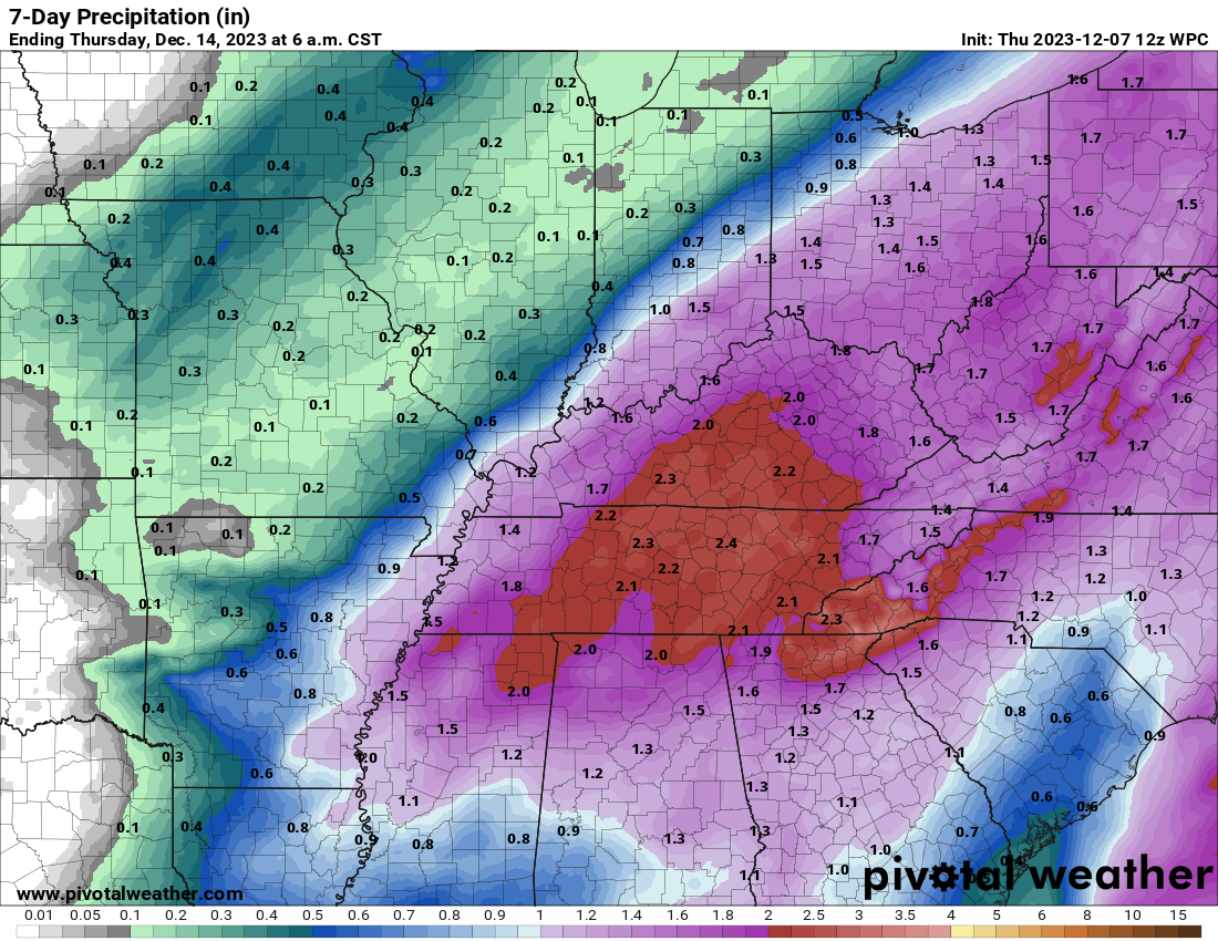
There have been some adjustments in the rain totals. The primary low will develop Friday night and move out of Oklahoma and Arkansas into Missouri and Illinois.
That first low will bring numerous showers and thunderstorms to the region.
A second wave of low pressure will develop Saturday and Saturday night along the Gulf of Mexico and will move north northeast along the incoming cold front.
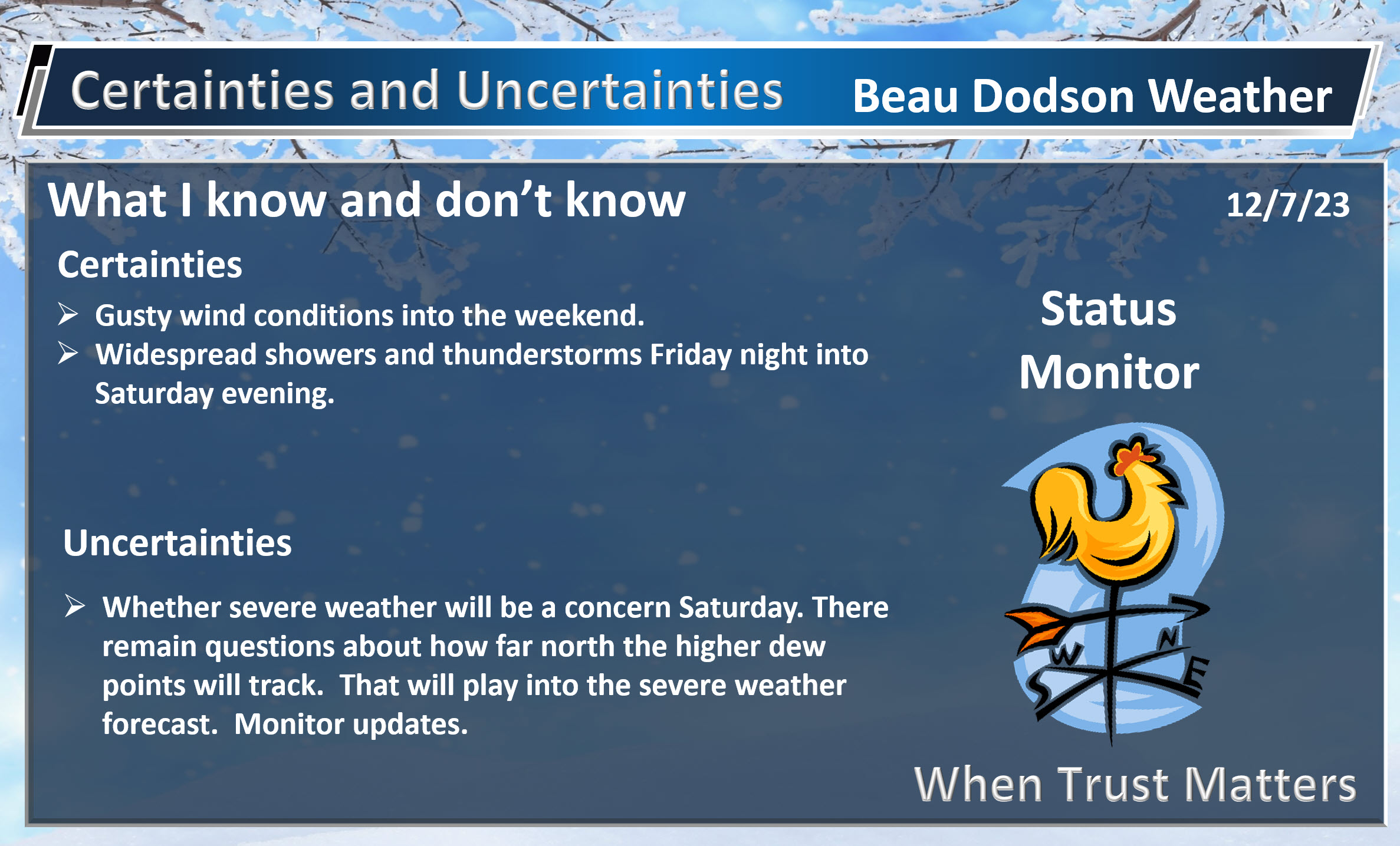
Whether this ends up being an actual area of low pressure or just a wave along the front remains a question.
It is an important question, because a stronger southern low would push rain farther west Saturday night and even on Sunday.
For now, it appears the wave of low pressure will increase rain coverage Saturday and Saturday night over at least Tennessee and Kentucky. Perhaps a tad farther west, as well.
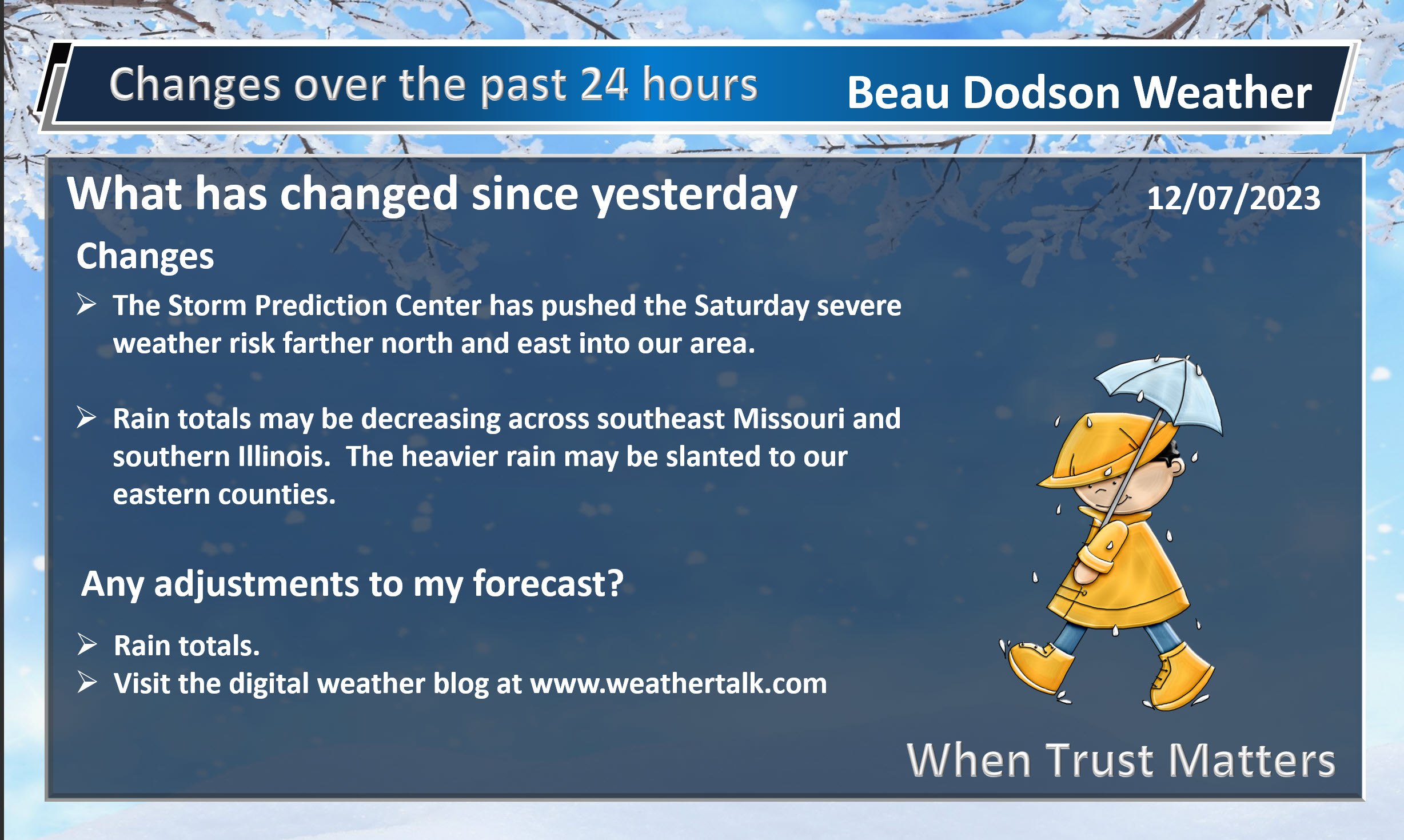
This is why rain totals will be higher over our eastern counties.
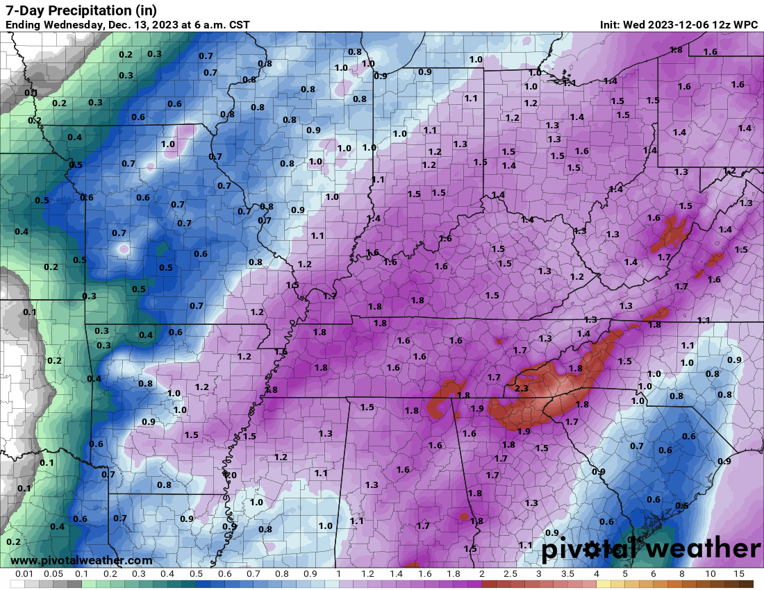
Here is the newest WPC NOAA rainfall forecast.
Compare that to the one from yesterday.
Notice the southeast shift in the bigger totals. It is possible we aren’t finished with the shifts towards lower totals over some counties. This is all highly dependent on that second wave of low pressure along the front.
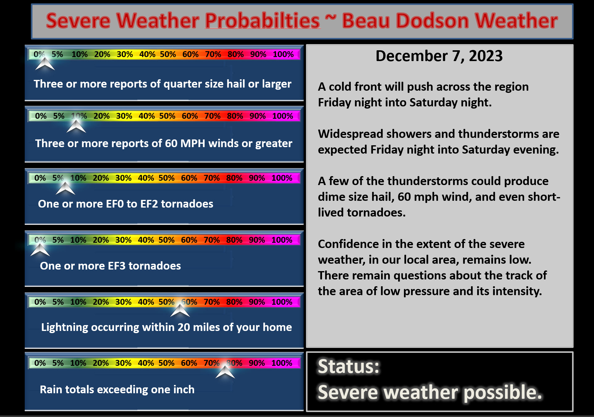
I can’t rule out severe weather.
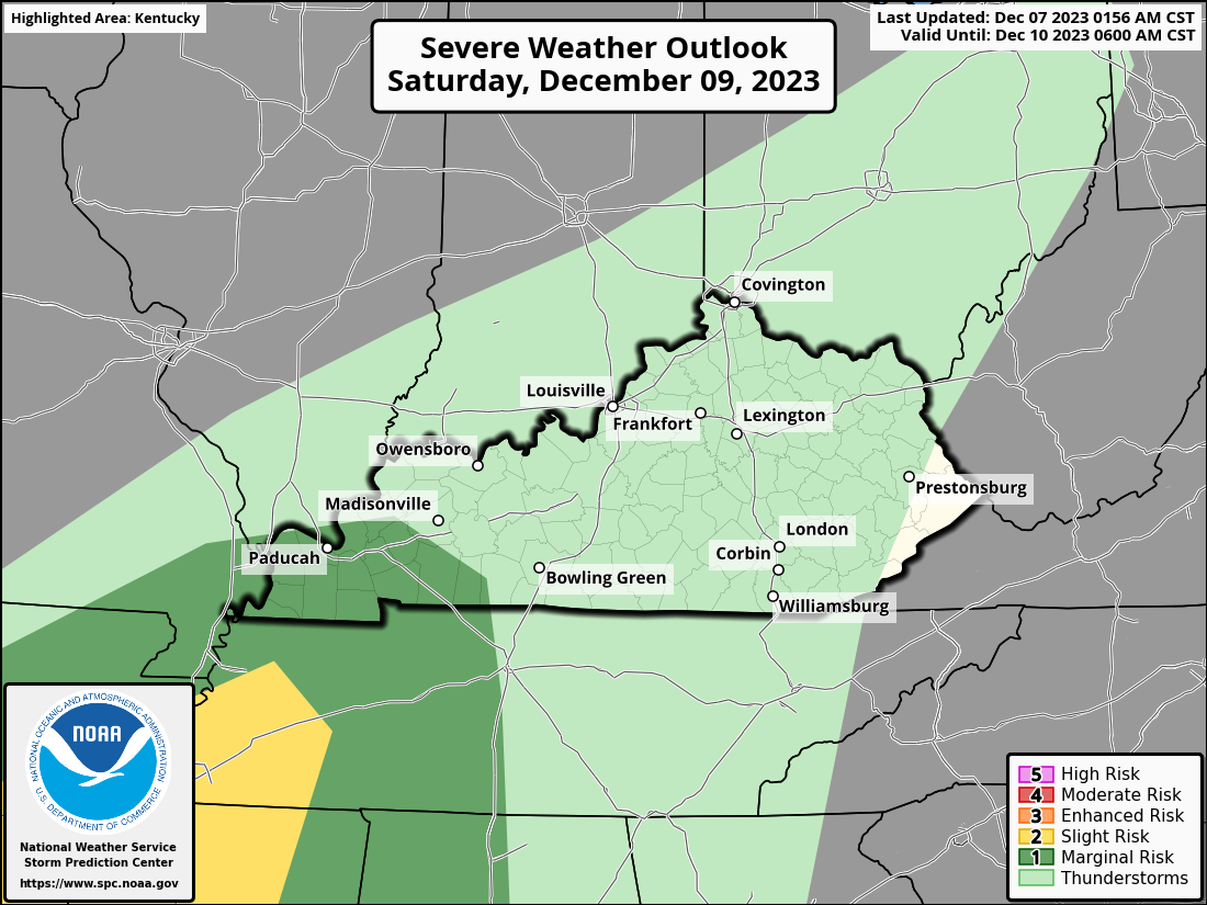
The Storm Prediction Center has outlined our region for a level one risk of severe weather Saturday.
You can see that here.
We aren’t finished with adjustments to this. It is possible they remove us from the threat of severe weather if the first area of low pressure isn’t as strong or the system is more progressive.
Overall, no changes to my forecast. A low end severe risk Saturday if conditions come together just right. The higher risk of severe weather will likely remain to our south. Monitor updates and your Beau Dodson Weather App.
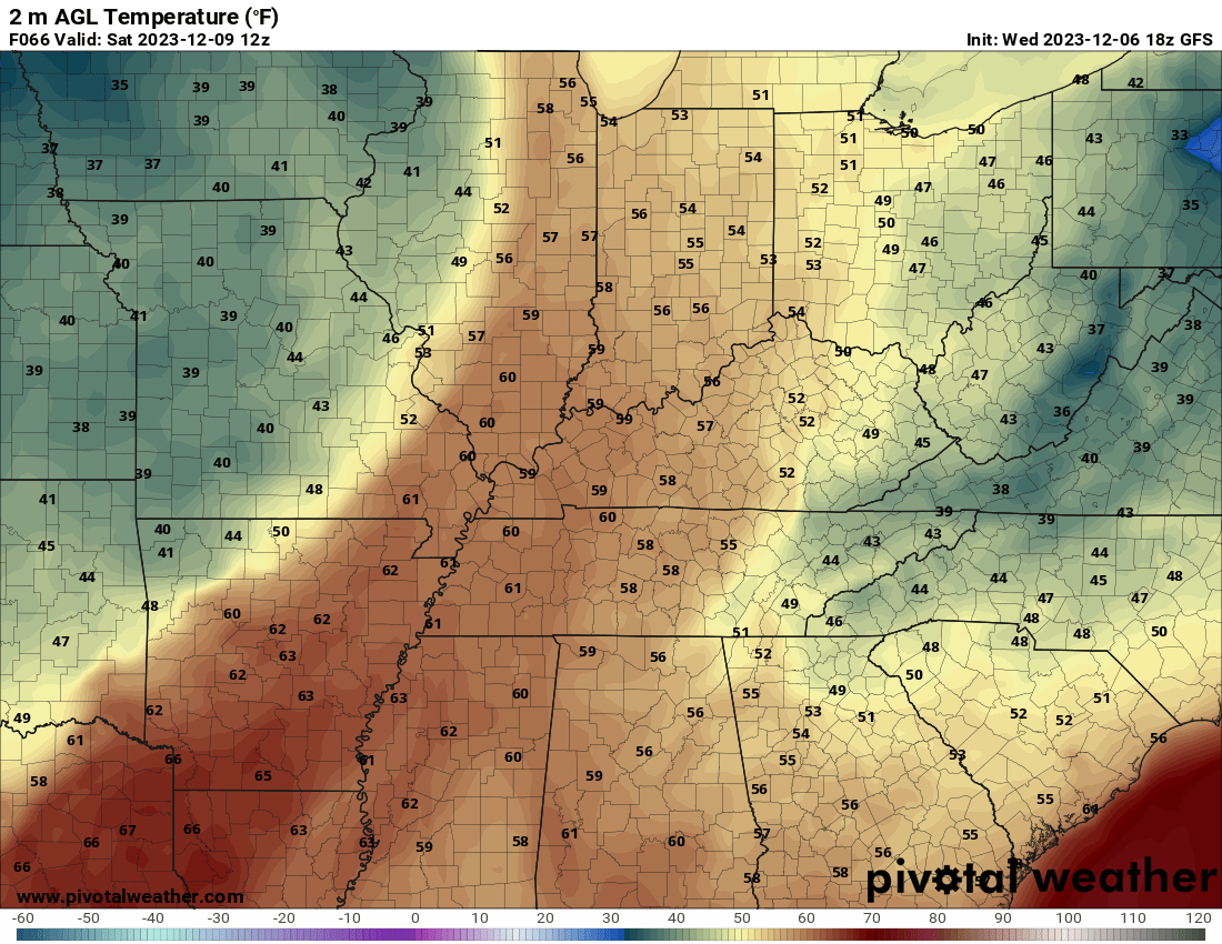
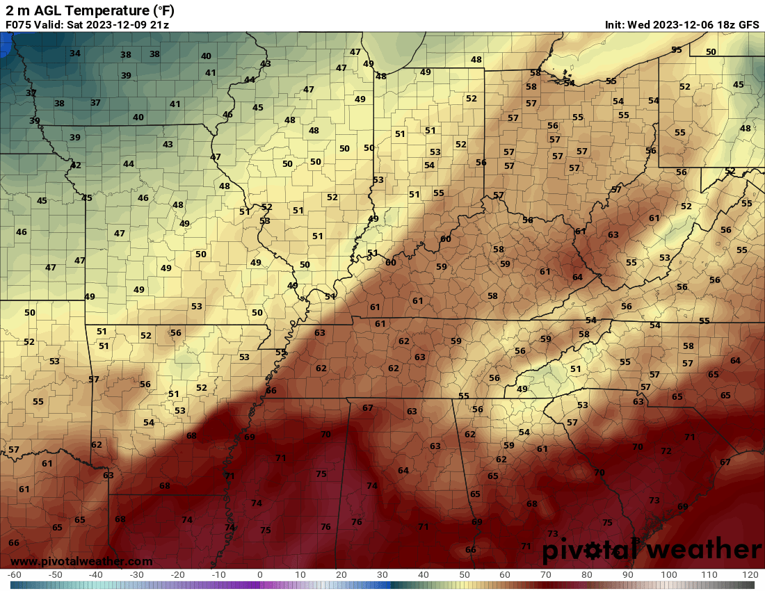
Temperatures are likely to fall Saturday from west to east behind the cold front.
6 AM temperatures
Afternoon temperatures
A few showers may remain into Sunday. I can’t rule out the rain ending as a rain/snow mix. No accumulation expected, at this time. Monitor updates.
Dry conditions Sunday night into Wednesday. No extremes.
.
Click here if you would like to return to the top of the page.
This outlook covers southeast Missouri, southern Illinois, western Kentucky, and far northwest Tennessee.
.
Today’s Storm Prediction Center’s Severe Weather Outlook
Light green is where thunderstorms may occur but should be below severe levels.
Dark green is a level one risk. Yellow is a level two risk. Orange is a level three (enhanced) risk. Red is a level four (moderate) risk. Pink is a level five (high) risk.
One is the lowest risk. Five is the highest risk.
A severe storm is one that produces 58 mph wind or higher, quarter size hail, and/or a tornado.
Explanation of tables. Click here.

.
Tornado Probability Outlook

.
Large Hail Probability Outlook

.
High wind Probability Outlook

.
Tomorrow’s severe weather outlook.

.
Day Three Severe Weather Outlook

.

.
The images below are from NOAA’s Weather Prediction Center.
24-hour precipitation outlook..
 .
.
.
48-hour precipitation outlook.
. .
.
![]()
_______________________________________
.

Click here if you would like to return to the top of the page.
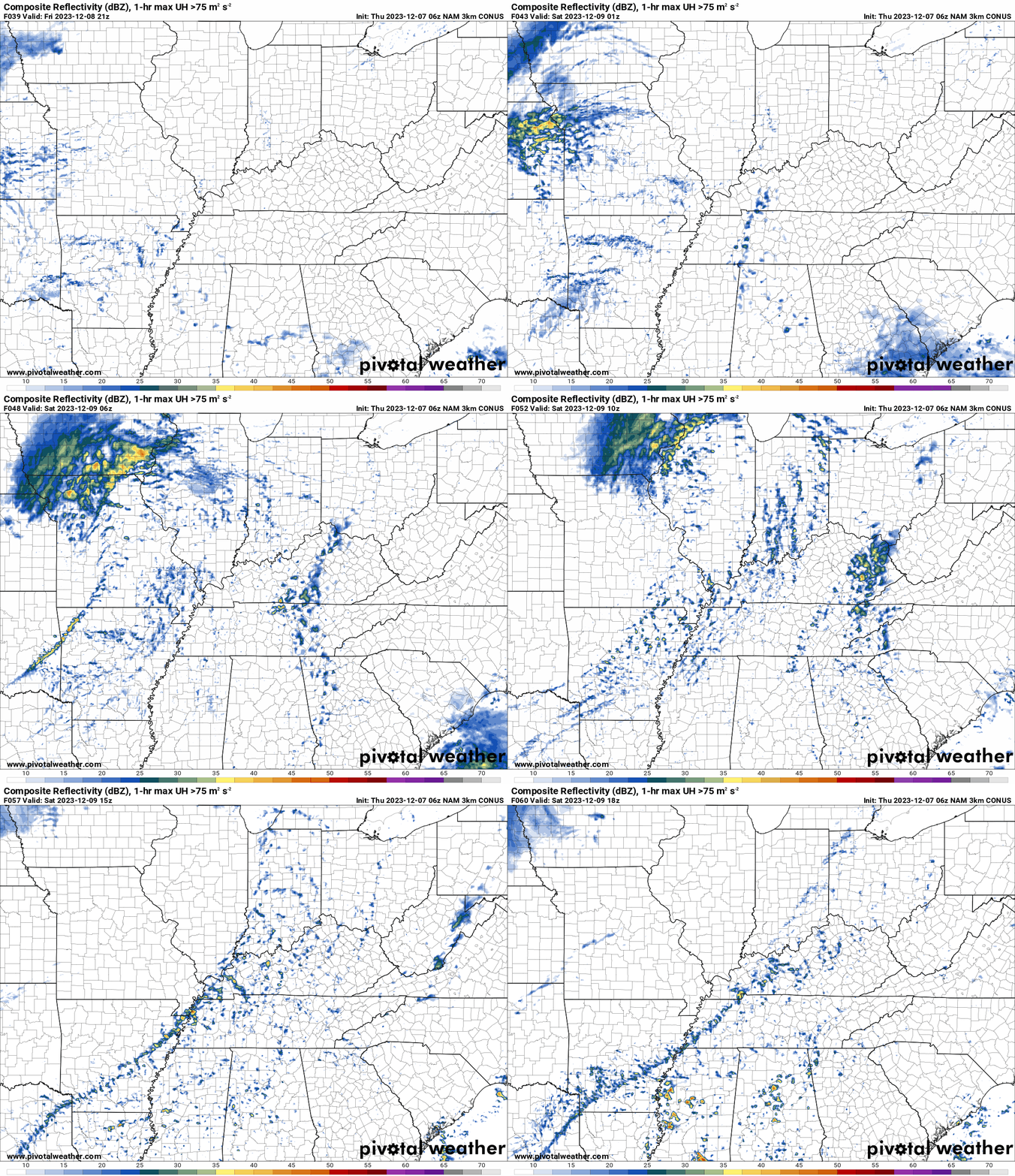
Again, as a reminder, these are models. They are never 100% accurate. Take the general idea from them.
What should I take from these?
- The general idea and not specifics. Models usually do well with the generalities.
- The time-stamp is located in the upper left corner.
.
What am I looking at?
You are looking at computer model data. Meteorologists use many different models to forecast the weather.
Occasionally, these maps are in Zulu time. 12z=7 AM. 18z=1 PM. 00z=7 PM. 06z=1 AM
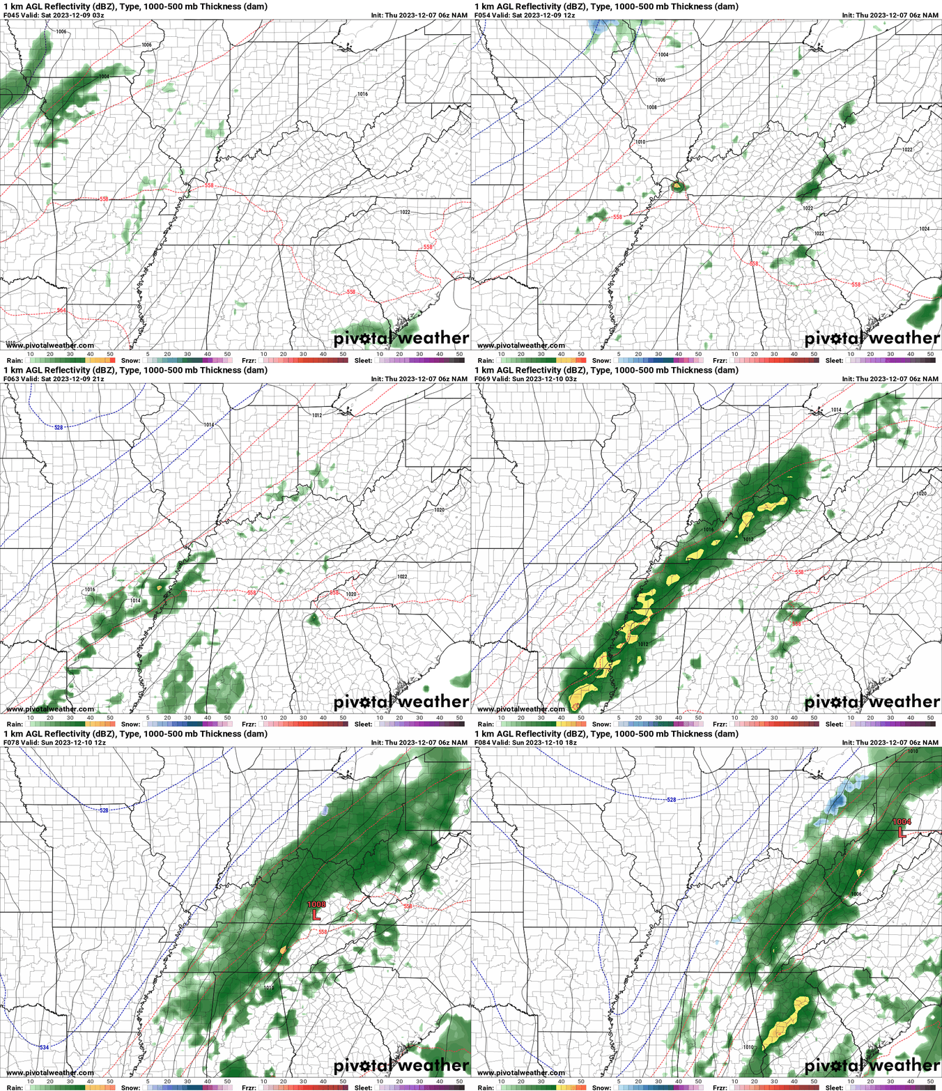
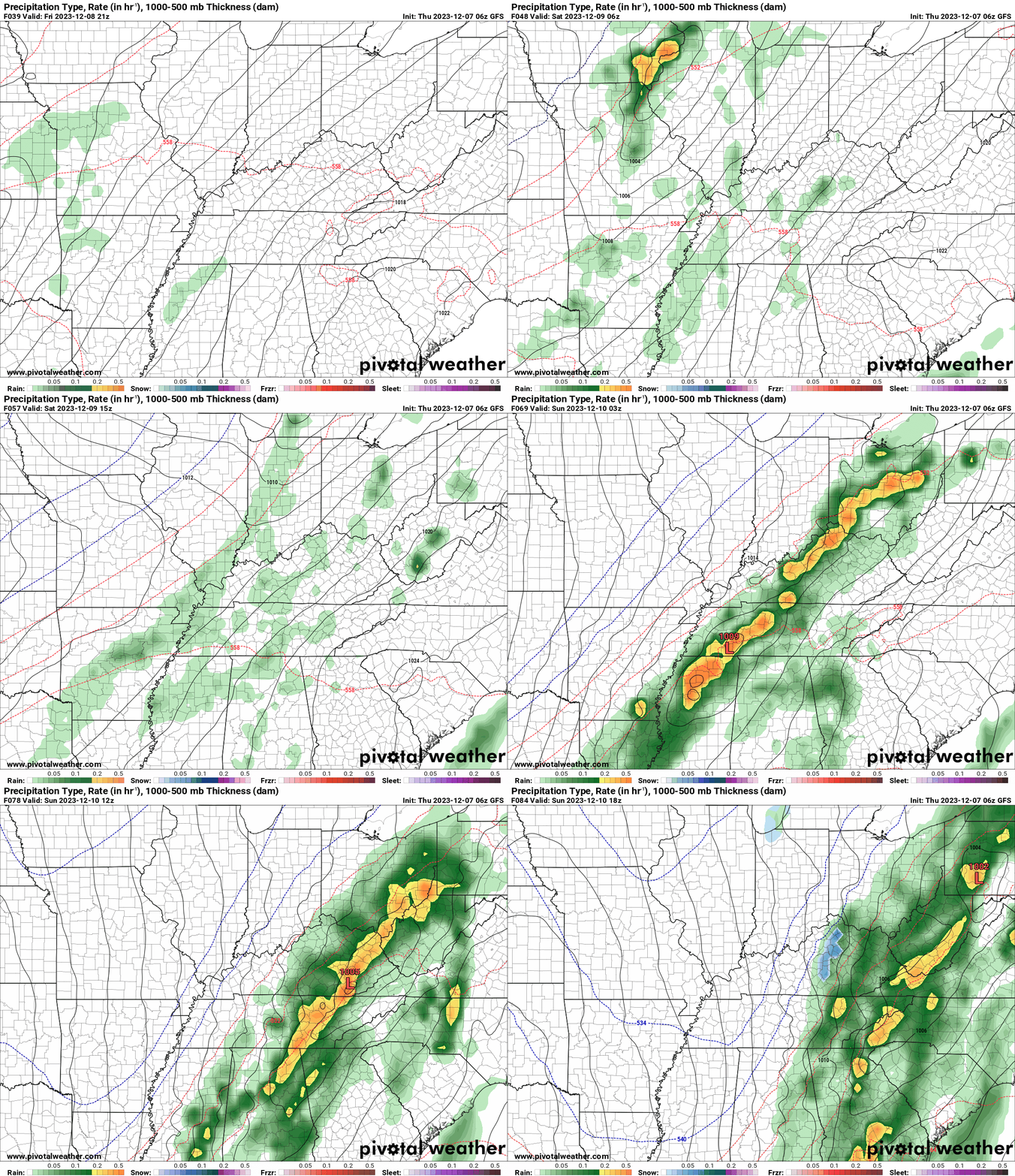
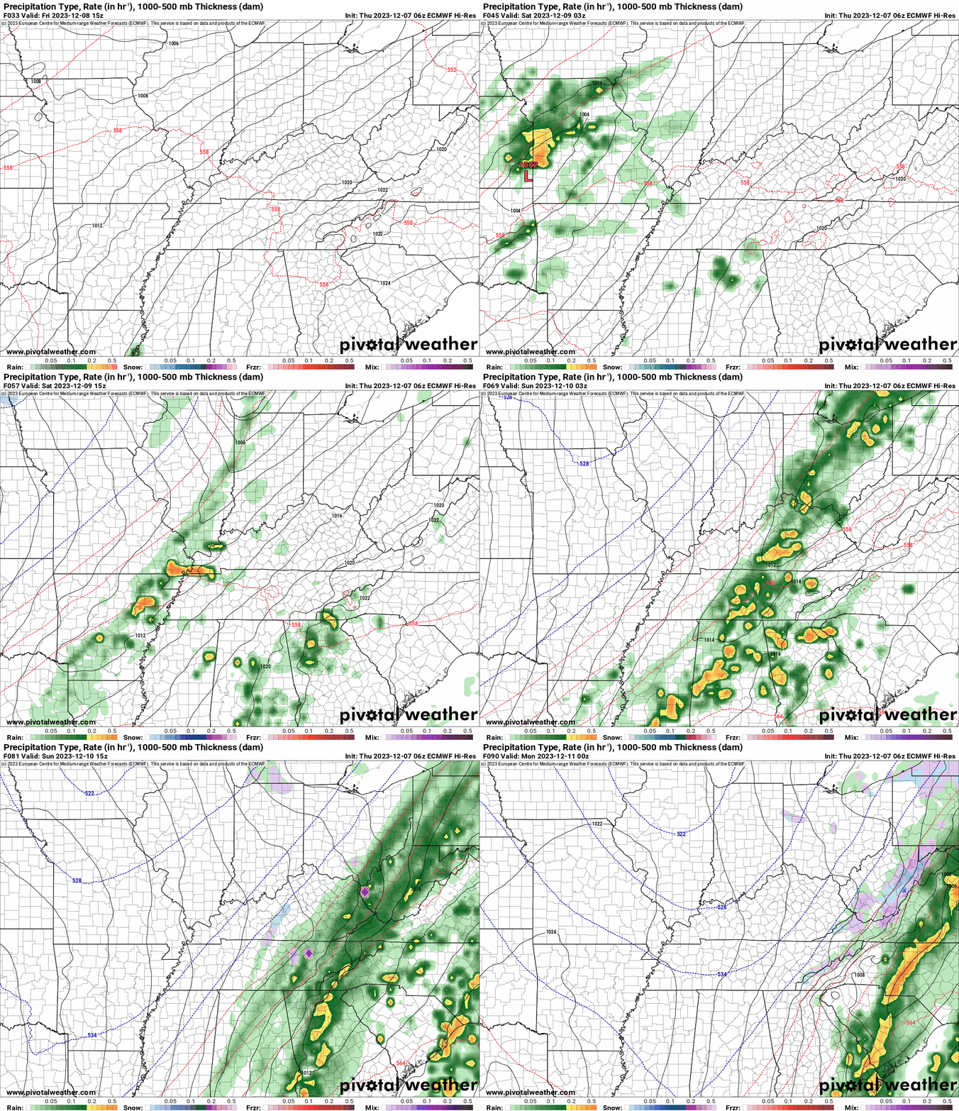
Green represents light rain. Dark green represents moderate rain. Yellow and orange represent heavier rain.
.
This animation is the NAM Model.
Occasionally, these maps are in Zulu time. 12z=6 AM. 18z=12 PM. 00z=6 PM. 06z=12 AM
Double click images to enlarge them.
.
This animation is the GFS Model.
Occasionally, these maps are in Zulu time. 12z=6 AM. 18z=12 PM. 00z=6 PM. 06z=12 AM
Double click images to enlarge them.
.
This animation is the EC Model.
Occasionally, these maps are in Zulu time. 12z=6 AM. 18z=12 PM. 00z=6 PM. 06z=12 AM
Double click images to enlarge them.
.
This animation is the NAM 3K Model.
Occasionally, these maps are in Zulu time. 12z=6 AM. 18z=12 PM. 00z=6 PM. 06z=12 AM
Double click images to enlarge them.
..![]()

.
Click here if you would like to return to the top of the page.
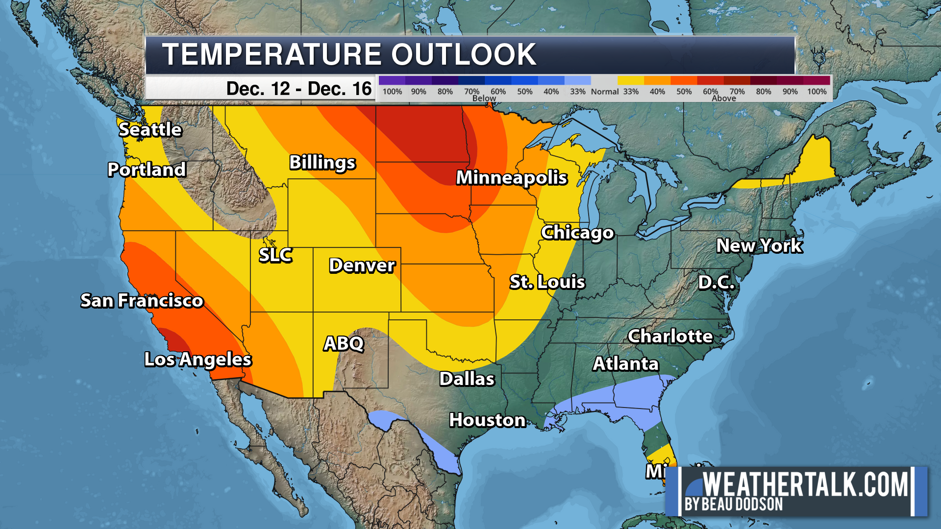
.Average high temperatures for this time of the year are around 90 degrees.
Average low temperatures for this time of the year are around 70 degrees.
Average precipitation during this time period ranges from 0.90″ to 1.20″
Six to Ten Day Outlook.
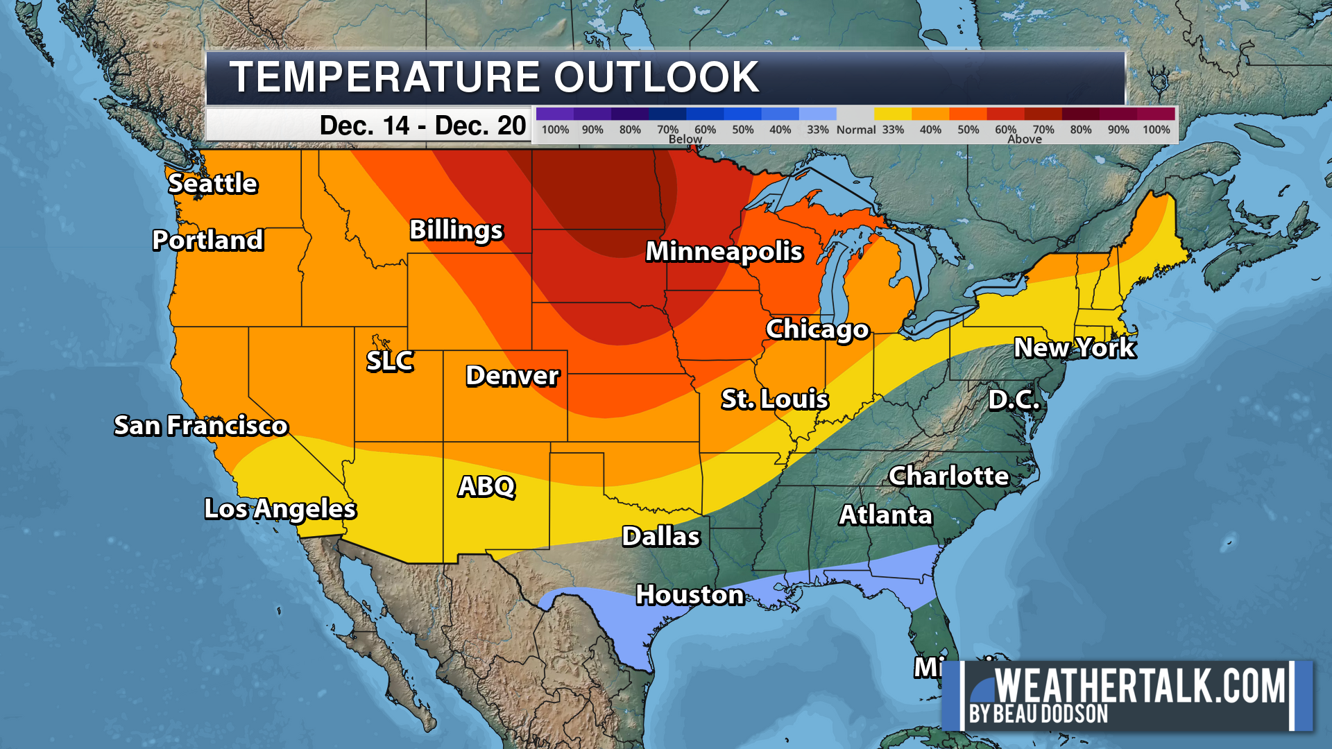
Blue is below average. Red is above average. The no color zone represents equal chances.
Average highs for this time of the year are in the lower 60s. Average lows for this time of the year are in the lower 40s.
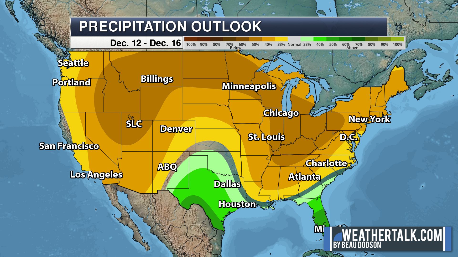
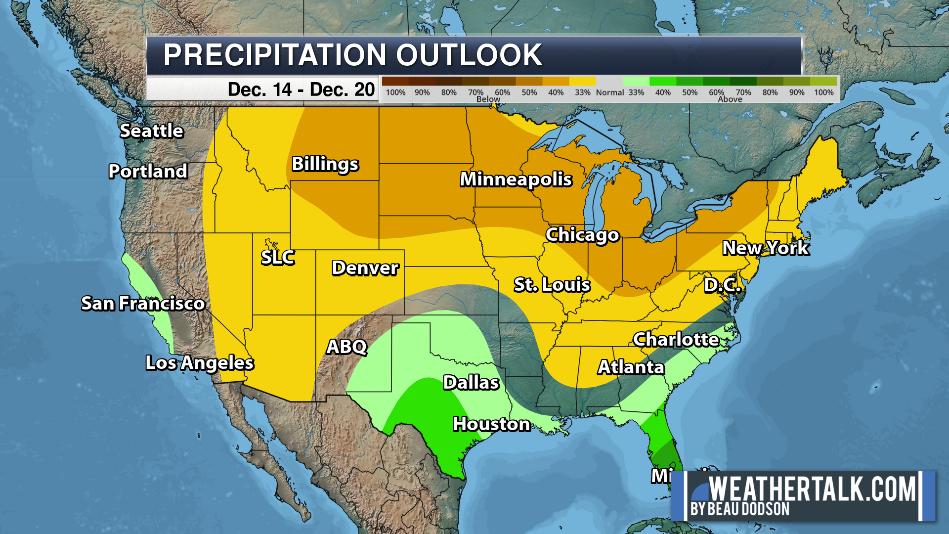
Green is above average precipitation. Yellow and brown favors below average precipitation. Average precipitation for this time of the year is around one inch per week.
.

Average low temperatures for this time of the year are around 70 degrees.
Average precipitation during this time period ranges from 0.90″ to 1.20″
.
.
![]()
The app is for subscribers. Subscribe at www.weathertalk.com/welcome then go to your app store and search for WeatherTalk
Subscribers, PLEASE USE THE APP. ATT and Verizon are not reliable during severe weather. They are delaying text messages.
The app is under WeatherTalk in the app store.
Apple users click here
Android users click here
.

Radars and Lightning Data
Interactive-city-view radars. Clickable watches and warnings.
https://wtalk.co/B3XHASFZ
If the radar is not updating then try another one. If a radar does not appear to be refreshing then hit Ctrl F5. You may also try restarting your browser.
Backup radar site in case the above one is not working.
https://weathertalk.com/morani
Regional Radar
https://imagery.weathertalk.com/prx/RadarLoop.mp4
** NEW ** Zoom radar with chaser tracking abilities!
ZoomRadar
Lightning Data (zoom in and out of your local area)
https://wtalk.co/WJ3SN5UZ
Not working? Email me at beaudodson@usawx.com
National map of weather watches and warnings. Click here.
Storm Prediction Center. Click here.
Weather Prediction Center. Click here.
.

Live lightning data: Click here.
Real time lightning data (another one) https://map.blitzortung.org/#5.02/37.95/-86.99
Our new Zoom radar with storm chases
.
.

Interactive GOES R satellite. Track clouds. Click here.
GOES 16 slider tool. Click here.
College of DuPage satellites. Click here
.

Here are the latest local river stage forecast numbers Click Here.
Here are the latest lake stage forecast numbers for Kentucky Lake and Lake Barkley Click Here.
.
.
Find Beau on Facebook! Click the banner.









 .
.