
Click one of the links below to take you directly to that section
![]()
![]()
![]()
![]()
![]()
![]()
![]()
Do you have any suggestions or comments? Email me at beaudodson@usawx.com
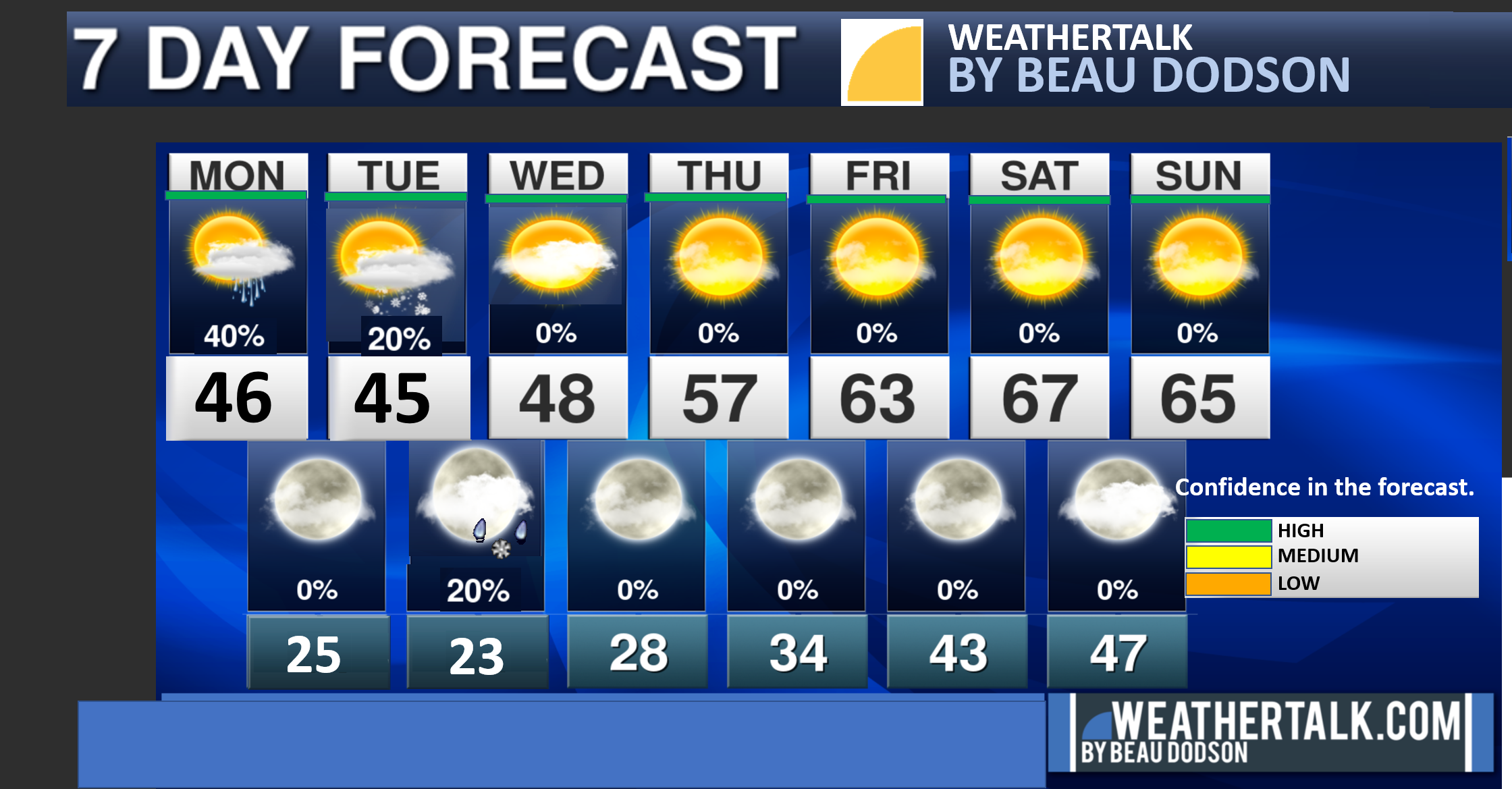
Seven-day forecast for southeast Missouri, southern Illinois, western Kentucky, and western Tennessee.
This is a BLEND for the region. Scroll down to see the region by region forecast.
THE FORECAST IS GOING TO VARY FROM LOCATION TO LOCATION. Scroll down to see the region by region forecast.
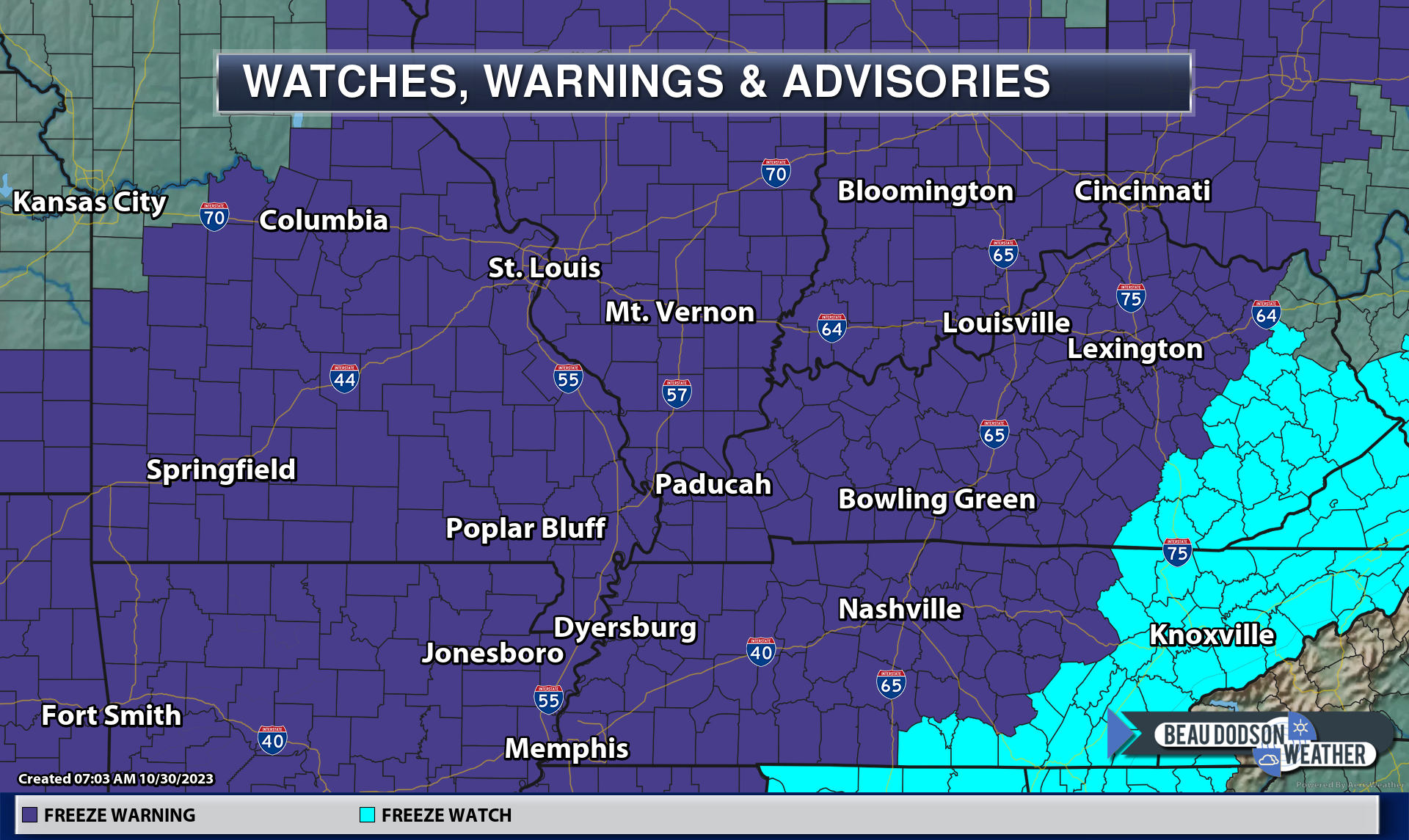
A freeze warning has been issued for tonight.
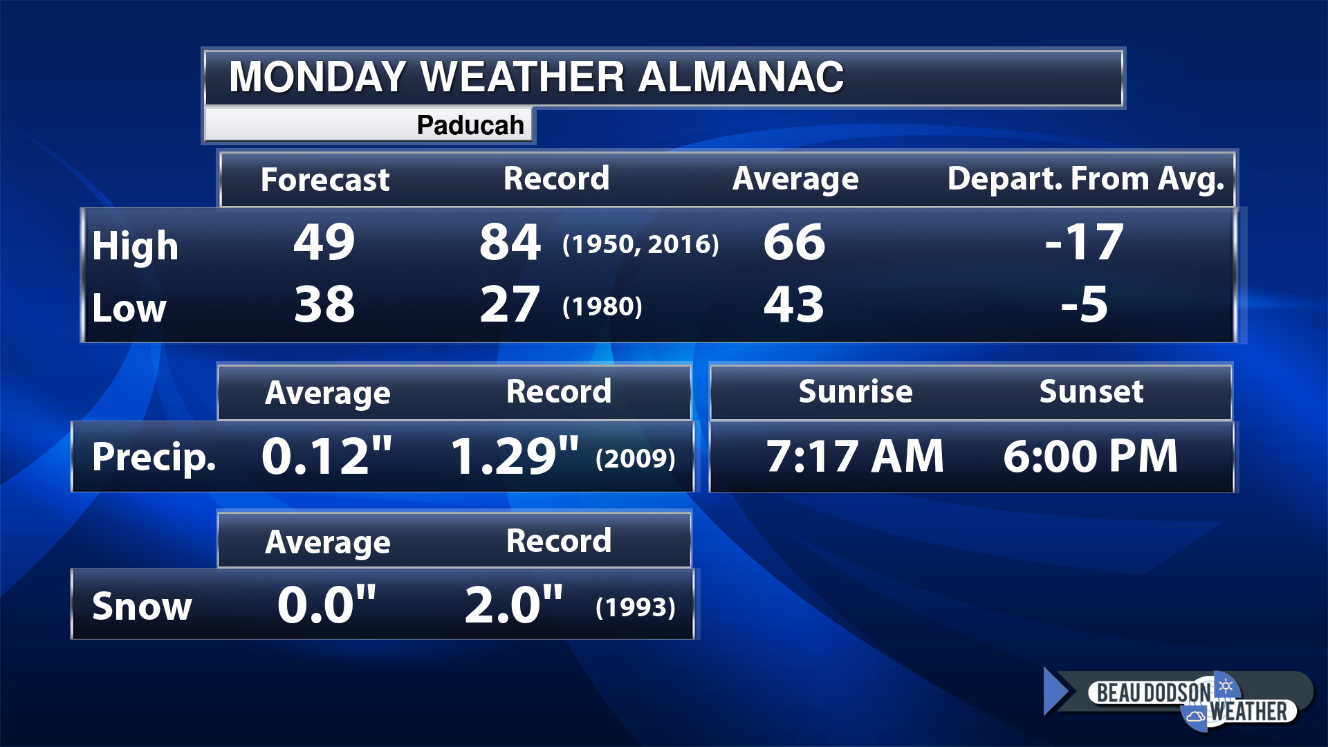
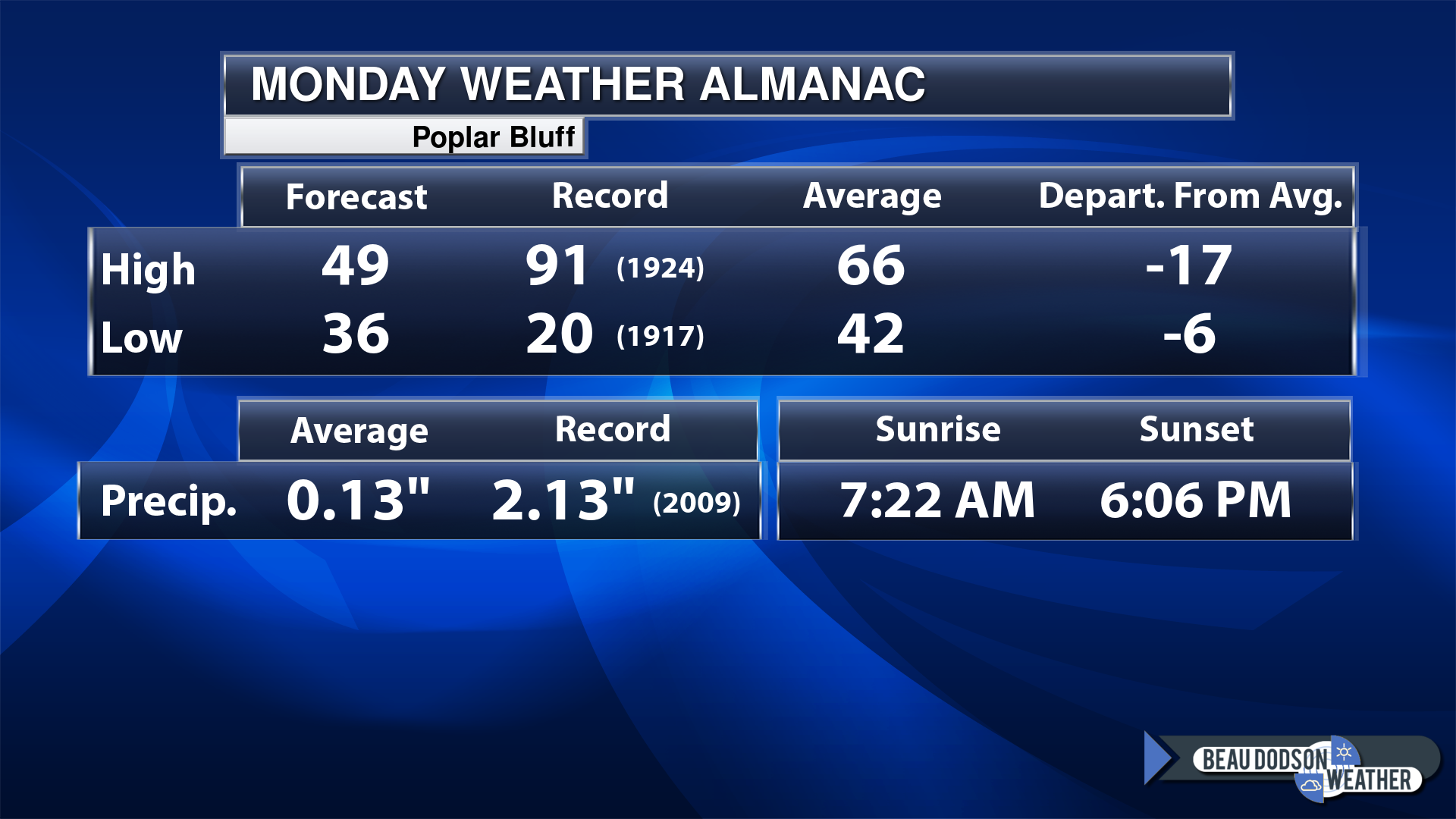
Today’s Local Almanacs (for a few select cities). Your location will be comparable.
Note, the low is this morning’s low and not tomorrows.
Today’s almanac numbers from a few select local cities.
The forecast temperature shows you today’s expected high and this morning’s low.
The graphic shows you the record high and record low for today. It shows you what year that occurred, as well.
It then shows you what today’s average temperature is.
Then, it shows you the departures (how may degrees above or below average temperatures will be ).
It shows you the average precipitation for today. Average comes from thirty years of rain totals.
It also shows you the record rainfall for the date and what year that occurred.
The sunrise and sunset are also shown.

If you have not subscribed to my YouTube Channel then click on this link and it will take you to my videos.
Click the button below and it will take you to the Beau Dodson YouTube Channel.

![]()
48-hour forecast


.

.
Monday to Monday
1. Is lightning in the forecast? No.
2. Are severe thunderstorms in the forecast? No.
3. Is flash flooding in the forecast? No.
4. Will the heat index exceed 100 degrees? No.
5. Will the wind chill dip below 10 degrees? No.
6. Is measurable snow and/or sleet in the forecast? No.
7. Is freezing rain/ice in the forecast? No.
Freezing rain is rain that falls and instantly freezes on objects such as trees and power lines
.

.
Monday, October 30, 2023
Confidence in the forecast? High Confidence
Monday Forecast: Chilly. Breezy. Damp. A chance of scattered showers. Mainly during the morning hours.
What is the chance of precipitation?
Far northern southeast Missouri ~ 30%
Southeast Missouri ~ 30%
The Missouri Bootheel ~ 30%
I-64 Corridor of southern Illinois ~ 40%
Southern Illinois ~ 40%
Extreme southern Illinois (southern seven counties) ~ 40%
Far western Kentucky (Purchase area) ~ 60%
The Pennyrile area of western KY ~ 60%
Northwest Kentucky (near Indiana border) ~ 60%
Northwest Tennessee ~ 40%
Coverage of precipitation: Scattered
Timing of the precipitation: Higher chances before noon vs after noon.
Far northern southeast Missouri ~ 44° to 48°
Southeast Missouri ~ 44° to 48°
The Missouri Bootheel ~ 44° to 48°
I-64 Corridor of southern Illinois ~ 44° to 48°
Southern Illinois ~ 44° to 48°
Extreme southern Illinois (southern seven counties) ~ 44° to 48°
Far western Kentucky ~ 44° to 48°
The Pennyrile area of western KY ~ 44° to 48°
Northwest Kentucky (near Indiana border) ~ 44° to 48°
Northwest Tennessee ~ 44° to 48°
Winds will be from this direction: North 15 to 25 mph. Gusty.
Wind chill or heat index (feels like) temperature forecast: 36° to 44°
What impacts are anticipated from the weather?
Should I cancel my outdoor plans? No, but it will be damp and windy. Colder.
UV Index: 2. Low.
Sunrise: 7:15 AM
Sunset: 6:00 PM
.
Monday Night Forecast: Freeze warning. Partly cloudy. Colder. Patchy frost and or freeze conditions. Frost is more likely if the wind dies down.
What is the chance of precipitation?
Far northern southeast Missouri ~ 0%
Southeast Missouri ~ 0%
The Missouri Bootheel ~ 0%
I-64 Corridor of southern Illinois ~ 0%
Southern Illinois ~ 0%
Extreme southern Illinois (southern seven counties) ~ 0%
Far western Kentucky (Purchase area) ~ 0%
The Pennyrile area of western KY ~ 0%
Northwest Kentucky (near Indiana border) ~ 0%
Northwest Tennessee ~ 0%
Coverage of precipitation:
Timing of the precipitation:
Temperature range:
Far northern southeast Missouri ~ 22° to 25°
Southeast Missouri ~ 24° to 28°
The Missouri Bootheel ~ 26° to 30°
I-64 Corridor of southern Illinois ~ 22° to 25°
Southern Illinois ~ 23° to 26°
Extreme southern Illinois (southern seven counties) ~ 24° to 26°
Far western Kentucky ~ 24° to 28°
The Pennyrile area of western KY ~ 26° to 30°
Northwest Kentucky (near Indiana border) ~ 24° to 28°
Northwest Tennessee ~ 28° to 30°
Winds will be from this direction: North northwest 10 to 25 mph. Gusty.
Wind chill or heat index (feels like) temperature forecast: 20° to 30°
What impacts are anticipated from the weather? Frost and or freeze possible.
Should I cancel my outdoor plans? No
Moonrise: 7:08 PM
Moonset: 9:22 AM
The phase of the moon: Waning Gibbous
.
Tuesday, October 31, 2023
Confidence in the forecast? High Confidence
Tuesday Forecast: Chilly. Breezy. Increasing clouds. A slight chance of sprinkles or flurries.
What is the chance of precipitation?
Far northern southeast Missouri ~ 10%
Southeast Missouri ~ 10%
The Missouri Bootheel ~ 0%
I-64 Corridor of southern Illinois ~ 20%
Southern Illinois ~ 20%
Extreme southern Illinois (southern seven counties) ~ 10%
Far western Kentucky (Purchase area) ~ 10%
The Pennyrile area of western KY ~ 10%
Northwest Kentucky (near Indiana border) ~ 20%
Northwest Tennessee ~ 0%
Coverage of precipitation: Isolated
Timing of the precipitation: After 12 PM
Far northern southeast Missouri ~ 44° to 48°
Southeast Missouri ~ 44° to 48°
The Missouri Bootheel ~ 44° to 48°
I-64 Corridor of southern Illinois ~ 44° to 48°
Southern Illinois ~ 44° to 48°
Extreme southern Illinois (southern seven counties) ~ 44° to 48°
Far western Kentucky ~ 44° to 48°
The Pennyrile area of western KY ~ 44° to 48°
Northwest Kentucky (near Indiana border) ~ 44° to 48°
Northwest Tennessee ~ 44° to 48°
Winds will be from this direction: North northwest 15 to 25 mph. Gusty.
Wind chill or heat index (feels like) temperature forecast: 36° to 44°
What impacts are anticipated from the weather?
Should I cancel my outdoor plans? No
UV Index: 4. Moderate.
Sunrise: 7:18 AM
Sunset: 5:58 PM
.
Tuesday Night Forecast: Freeze warning. Record or near record lows. Evening clouds with a chance of sprinkles or flurries. Colder. Clearing overnight. Frost and/or freeze conditions developing.
What is the chance of precipitation?
Far northern southeast Missouri ~ 10%
Southeast Missouri ~ 10%
The Missouri Bootheel ~ 0%
I-64 Corridor of southern Illinois ~ 20%
Southern Illinois ~ 20%
Extreme southern Illinois (southern seven counties) ~ 20%
Far western Kentucky (Purchase area) ~ 20%
The Pennyrile area of western KY ~ 20%
Northwest Kentucky (near Indiana border) ~ 20%
Northwest Tennessee ~ 10%
Coverage of precipitation: Isolated
Timing of the precipitation: Before 2 AM
Temperature range:
Far northern southeast Missouri ~ 22° to 24°
Southeast Missouri ~ 24° to 28°
The Missouri Bootheel ~ 25° to 30°
I-64 Corridor of southern Illinois ~ 22° to 24°
Southern Illinois ~ 23° to 26°
Extreme southern Illinois (southern seven counties) ~ 24° to 26°
Far western Kentucky ~ 24° to 28°
The Pennyrile area of western KY ~ 26° to 30°
Northwest Kentucky (near Indiana border) ~ 24° to 28°
Northwest Tennessee ~ 28° to 30°
Winds will be from this direction: North northwest 10 to 25 mph. Gusty.
Wind chill or heat index (feels like) temperature forecast: 18° to 28°
What impacts are anticipated from the weather? Frost and freeze conditions.
Should I cancel my outdoor plans? No
Moonrise: 7:53 PM
Moonset: 10:31 AM
The phase of the moon: Waning Gibbous
.
Wednesday, November 1, 2023
Confidence in the forecast? High Confidence
Wednesday Forecast: Mostly sunny. Cold.
What is the chance of precipitation?
Far northern southeast Missouri ~ 0%
Southeast Missouri ~ 0%
The Missouri Bootheel ~ 0%
I-64 Corridor of southern Illinois ~ 0%
Southern Illinois ~ 0%
Extreme southern Illinois (southern seven counties) ~ 0%
Far western Kentucky (Purchase area) ~ 0%
The Pennyrile area of western KY ~ 0%
Northwest Kentucky (near Indiana border) ~ 0%
Northwest Tennessee ~ 0%
Coverage of precipitation:
Timing of the precipitation:
Far northern southeast Missouri ~ 44° to 48°
Southeast Missouri ~ 44° to 48°
The Missouri Bootheel ~ 44° to 48°
I-64 Corridor of southern Illinois ~ 44° to 48°
Southern Illinois ~ 44° to 48°
Extreme southern Illinois (southern seven counties) ~ 44° to 48°
Far western Kentucky ~ 44° to 48°
The Pennyrile area of western KY ~ 44° to 48°
Northwest Kentucky (near Indiana border) ~ 44° to 48°
Northwest Tennessee ~ 44° to 48°
Winds will be from this direction: North northwest 6 to 12 mph.
Wind chill or heat index (feels like) temperature forecast: 36° to 44°
What impacts are anticipated from the weather?
Should I cancel my outdoor plans? No
UV Index: 4. Moderate.
Sunrise: 7:20 AM
Sunset: 5:57 PM
.
Wednesday Night Forecast: Freeze warning. Mostly clear. Cold.
What is the chance of precipitation?
Far northern southeast Missouri ~ 0%
Southeast Missouri ~ 0%
The Missouri Bootheel ~ 0%
I-64 Corridor of southern Illinois ~ 0%
Southern Illinois ~ 0%
Extreme southern Illinois (southern seven counties) ~ 0%
Far western Kentucky (Purchase area) ~ 0%
The Pennyrile area of western KY ~ 0%
Northwest Kentucky (near Indiana border) ~ 0%
Northwest Tennessee ~ 0%
Coverage of precipitation:
Timing of the precipitation:
Temperature range:
Far northern southeast Missouri ~ 23° to 26°
Southeast Missouri ~ 24° to 26°
The Missouri Bootheel ~ 26° to 28°
I-64 Corridor of southern Illinois ~ 23° to 26°
Southern Illinois ~ 24° to 26°
Extreme southern Illinois (southern seven counties) ~ 24° to 26°
Far western Kentucky ~ 24° to 26°
The Pennyrile area of western KY ~ 26° to 28°
Northwest Kentucky (near Indiana border) ~ 23° to 26°
Northwest Tennessee ~ 26° to 28°
Winds will be from this direction: North northwest 10 to 25 mph. Gusty.
Wind chill or heat index (feels like) temperature forecast: 22° to 28°
What impacts are anticipated from the weather? Freeze conditions
Should I cancel my outdoor plans? No
Moonrise: 8:45 PM
Moonset: 11:36 AM
The phase of the moon: Waning Gibbous
.
Thursday, November 2, 2023
Confidence in the forecast? High Confidence
Thursday Forecast: Mostly sunny.
What is the chance of precipitation?
Far northern southeast Missouri ~ 0%
Southeast Missouri ~ 0%
The Missouri Bootheel ~ 0%
I-64 Corridor of southern Illinois ~ 0%
Southern Illinois ~ 0%
Extreme southern Illinois (southern seven counties) ~ 0%
Far western Kentucky (Purchase area) ~ 0%
The Pennyrile area of western KY ~ 0%
Northwest Kentucky (near Indiana border) ~ 0%
Northwest Tennessee ~ 0%
Coverage of precipitation:
Timing of the precipitation:
Far northern southeast Missouri ~ 53° to 56°
Southeast Missouri ~ 53° to 56°
The Missouri Bootheel ~ 53° to 56°
I-64 Corridor of southern Illinois ~ 53° to 56°
Southern Illinois ~ 53° to 56°
Extreme southern Illinois (southern seven counties) ~ 53° to 56°
Far western Kentucky ~ 53° to 56°
The Pennyrile area of western KY ~ 53° to 56°
Northwest Kentucky (near Indiana border) ~ 53° to 56°
Northwest Tennessee ~ 53° to 56°
Winds will be from this direction: Becoming south southwest 7 to 14 mph
Wind chill or heat index (feels like) temperature forecast: 50° to 55°
What impacts are anticipated from the weather?
Should I cancel my outdoor plans? No
UV Index: 4. Moderate.
Sunrise: 7:21 AM
Sunset: 5:56 PM
.
Thursday Night Forecast: Mostly clear. Frost possible.
What is the chance of precipitation?
Far northern southeast Missouri ~ 0%
Southeast Missouri ~ 0%
The Missouri Bootheel ~ 0%
I-64 Corridor of southern Illinois ~ 0%
Southern Illinois ~ 0%
Extreme southern Illinois (southern seven counties) ~ 0%
Far western Kentucky (Purchase area) ~ 0%
The Pennyrile area of western KY ~ 0%
Northwest Kentucky (near Indiana border) ~ 0%
Northwest Tennessee ~ 0%
Coverage of precipitation:
Timing of the precipitation:
Temperature range:
Far northern southeast Missouri ~ 33° to 36°
Southeast Missouri ~ 33° to 36°
The Missouri Bootheel ~ 33° to 36°
I-64 Corridor of southern Illinois ~ 33° to 36°
Southern Illinois ~ 33° to 36°
Extreme southern Illinois (southern seven counties) ~ 33° to 36°
Far western Kentucky ~ 33° to 36°
The Pennyrile area of western KY ~ 33° to 36°
Northwest Kentucky (near Indiana border) ~ 33° to 36°
Northwest Tennessee ~ 33° to 36°
Winds will be from this direction: South southwest 7 to 14 mph
Wind chill or heat index (feels like) temperature forecast: 33° to 36°
What impacts are anticipated from the weather? Frost conditions
Should I cancel my outdoor plans? No
Moonrise: 9:42 PM
Moonset: 12:32 AM
The phase of the moon: Waning Gibbous
.
Click here if you would like to return to the top of the page.

-
- Rain ending.
- Colder air has arrived.
- Snow flurries or light rain Tuesday/Tuesday night.
- Hard freeze tonight, Tuesday, and Wednesday night. Frost likely into Thursday night.
Weather advice:
Make sure you have three to five ways of receiving your severe weather information.
.Forecast Discussion
Good morning.
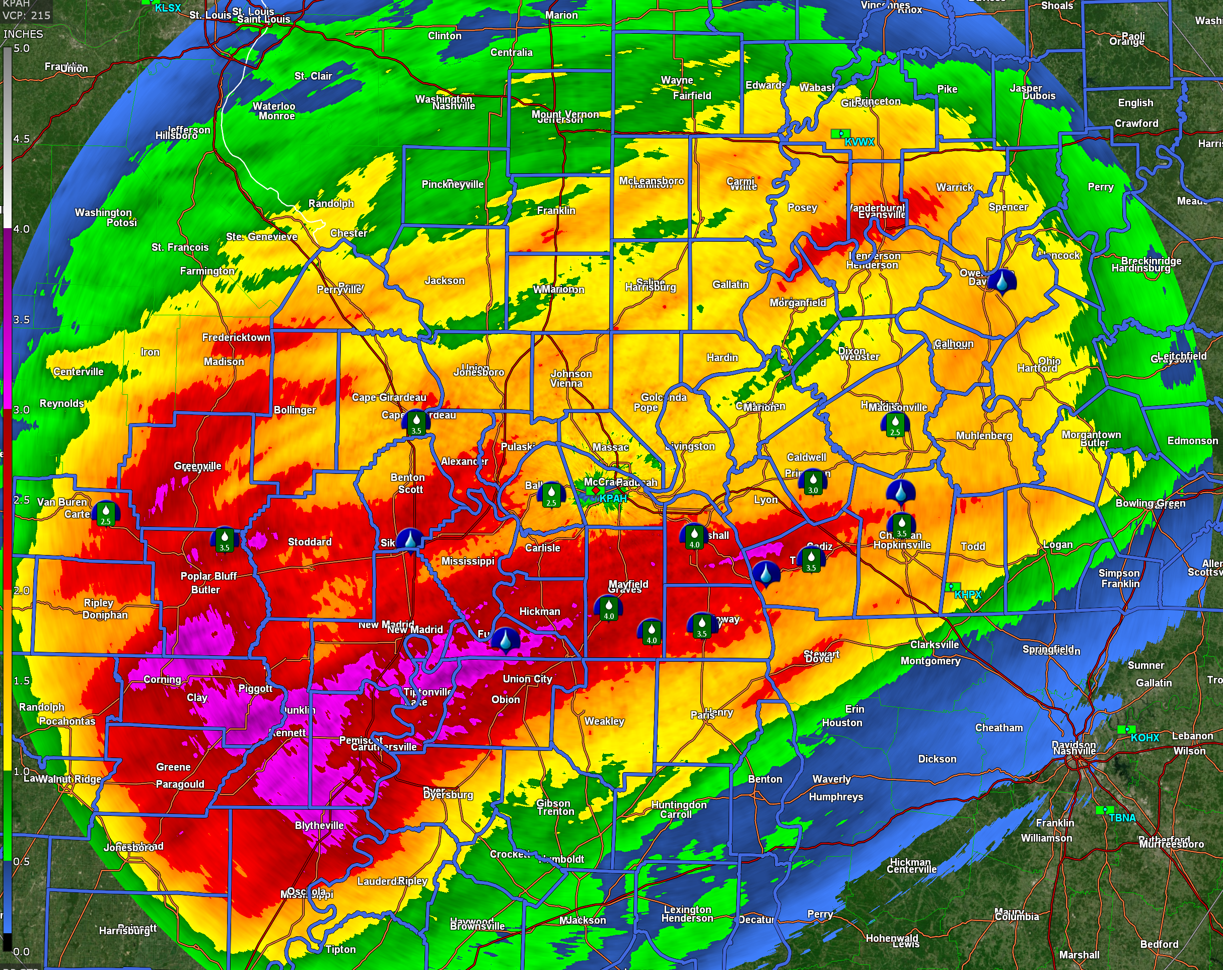
Well, it rained! Many areas received one to two inches of much needed rain. There were pockets of two to four inches mixed in across the region.
Radar estimated totals. Radar seemed to underestimate the totals.
Double click on the image to make it larger.
The yellow is one or more inches. Orange is one and a half to two inches. Red is two inches or more.
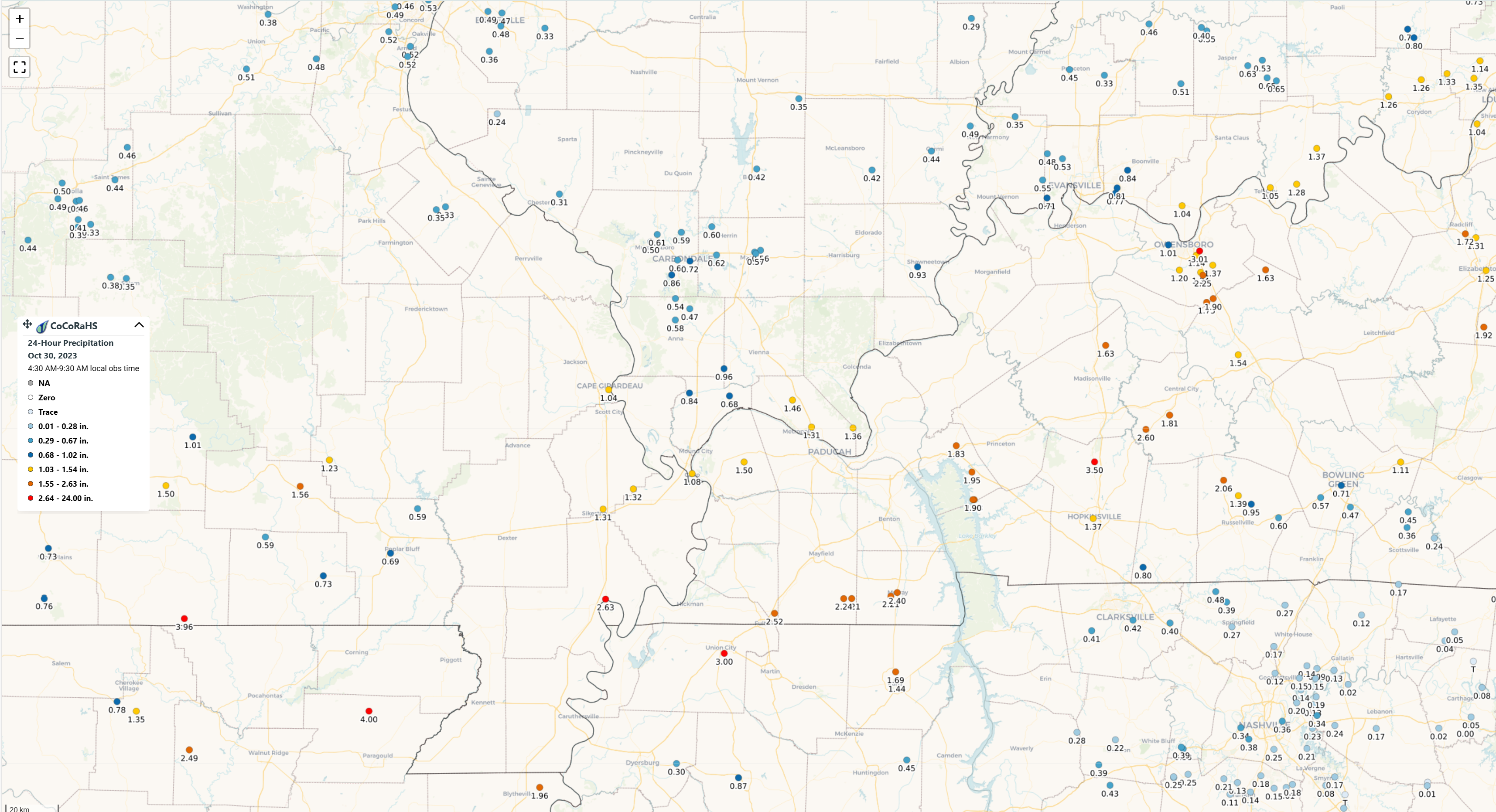
Here are some Cocorah’s reporting stations. Double click to enlarge the graphic.
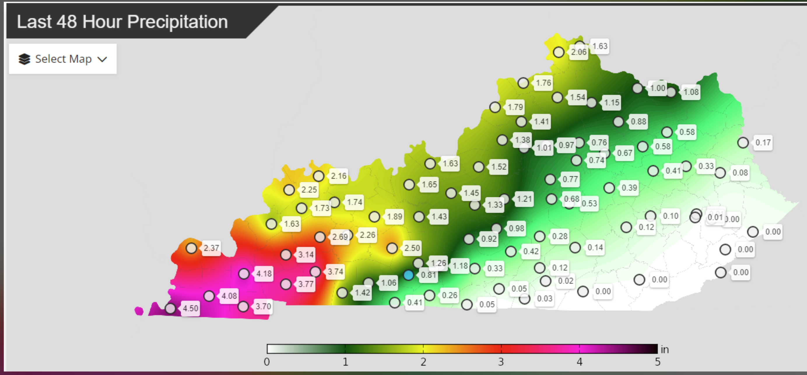
Here is the Kentucky meso-net reporting stations. Kentucky is the only local state with a meso-net.
You will notice that it is colder today. Highs will mostly be in the 40s.
Here were the 7 AM temperatures from across the region.
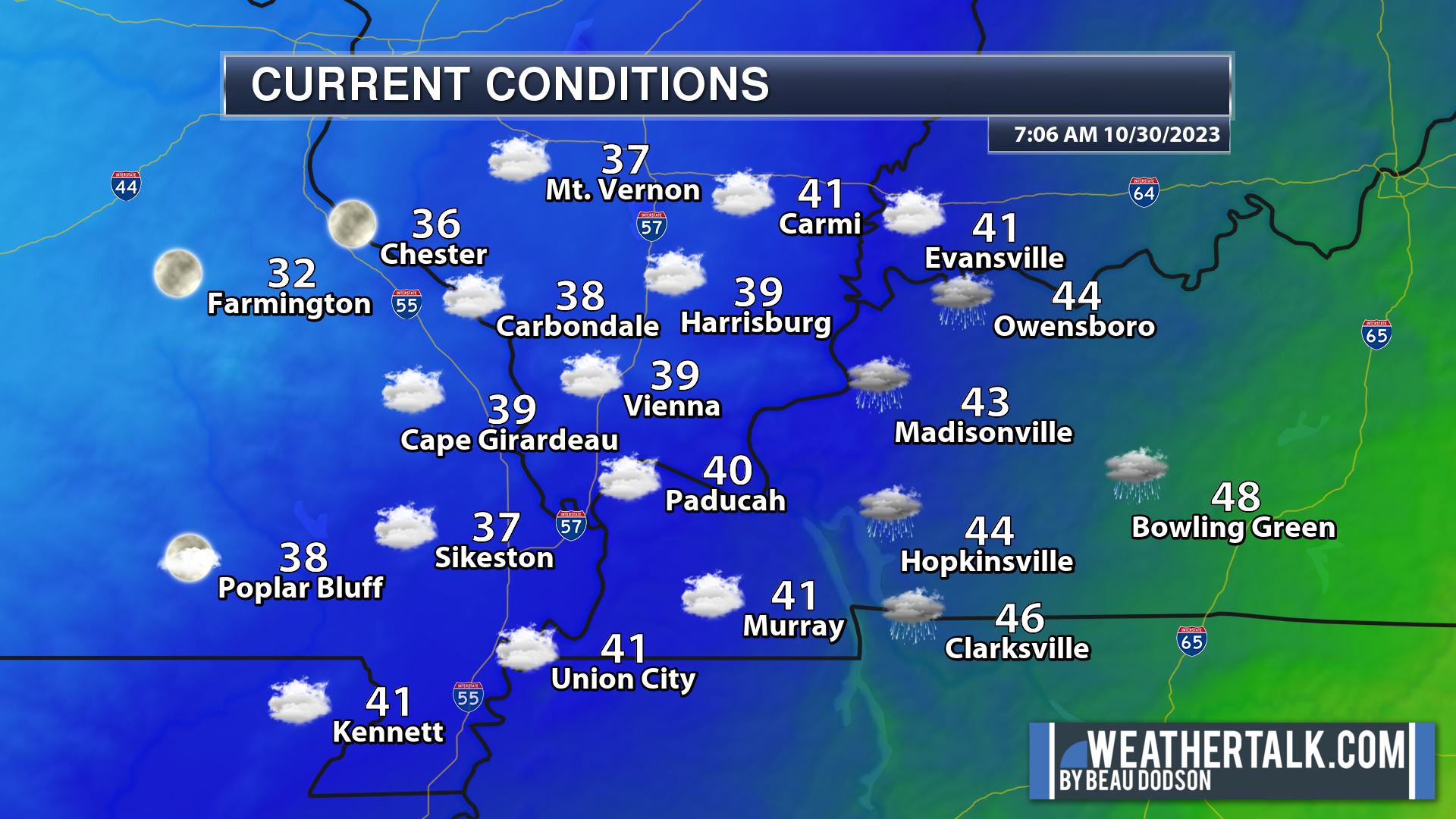
Much colder air will continue to push into the region over the coming days.
A hard frost and/or freeze is anticipated Monday, Tuesday, and Wednesday night.
The NWS has already issued freeze warnings in purple and freeze watches in light blue.
Again, the freeze arrives tonight. Additional below freezing temperatures Tuesday and Wednesday night. Frost is likely Thursday night, as well.
Halloween Forecast

It’s going to be a chilly one, so make sure you bundle up those little ghouls and goblins.
There will be a period or two of clouds. A secondary disturbance will move through the region. This will be accompanied by a few rain showers or snow flurries. Nothing of significance.
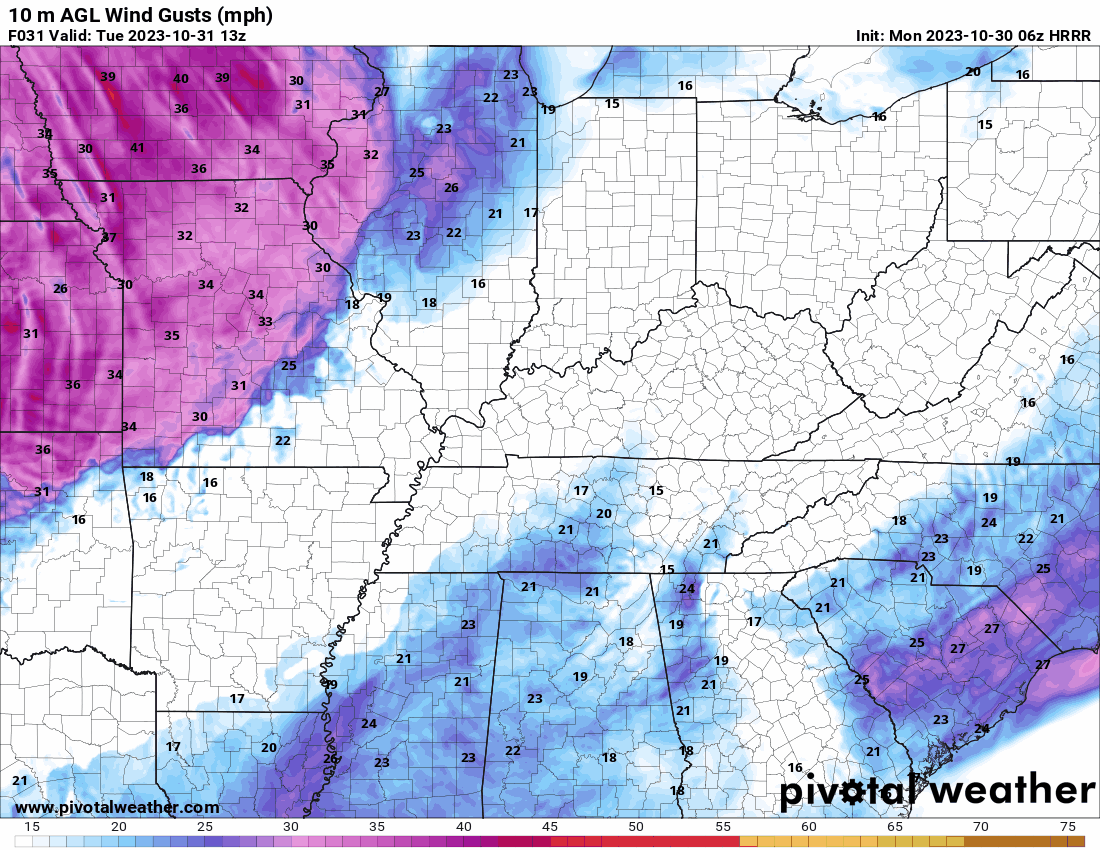
You can see that on the Hrrr model guidance. This band of sprinkles and flurries moves through during the afternoon and evening hours. Gusty winds, as well. Brrr.

Here is the wind gust forecast. You can see those northwesterly gusty winds arriving from the northwest. Sweeping across the region.
This animation takes us from late Tuesday morning into the overnight hours.
Halloween Night
As the sun sets and the Halloween festivities kick into high gear, we’ll be dealing with unseasonably cold weather. It will feel more like December than October.
Temperatures are expected to be in the 30s, and with the wind, it will feel even colder. Wind chill values will be in the 20s, so be prepared for quite the chill in the air.
This is quite the change of air-masses from just a few days ago (temperatures were in the 80s).
If you’re heading out for trick-or-treating or attending any outdoor events, it’s important to wear warm layers, gloves, and a hat. Make sure those costumes are cozy enough to keep the kids (and adults) warm. Common sense cold precautions! 🙂
Remember to keep a close eye on your little ones to ensure they stay warm and safe. Perhaps bring a thermos of hot cocoa or warm cider!
Despite the cold, let’s make the most of the upcoming Halloween evening and enjoy the spook-tacular fun.
Have a happy and safe Halloween!”
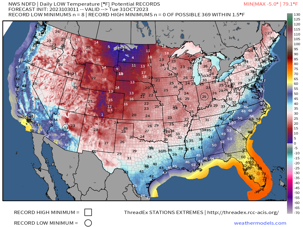
Check out these low temperature forecasts. The circles represent record low temperatures.
Tuesday morning
Wednesday morning
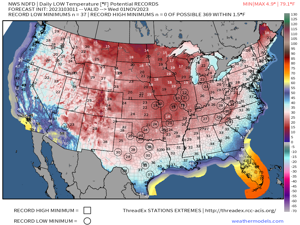
Thursday morning
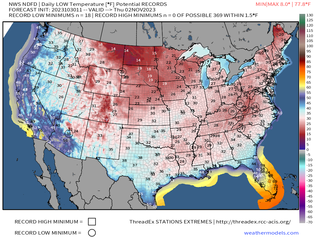
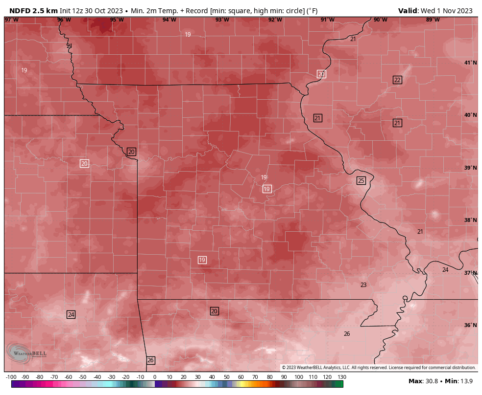
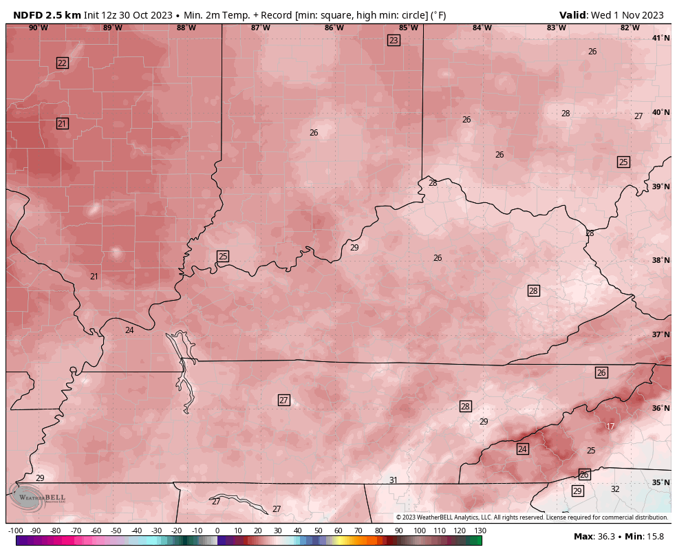
Let’s zoom in on Wednesday morning. This is likely to be the coldest morning. The squares represent where records may fall.
I am watching a storm system around November 7th through 11th. Somewhere in there.
This is the GFS model. It does well in the long range. It keeps showing an event.
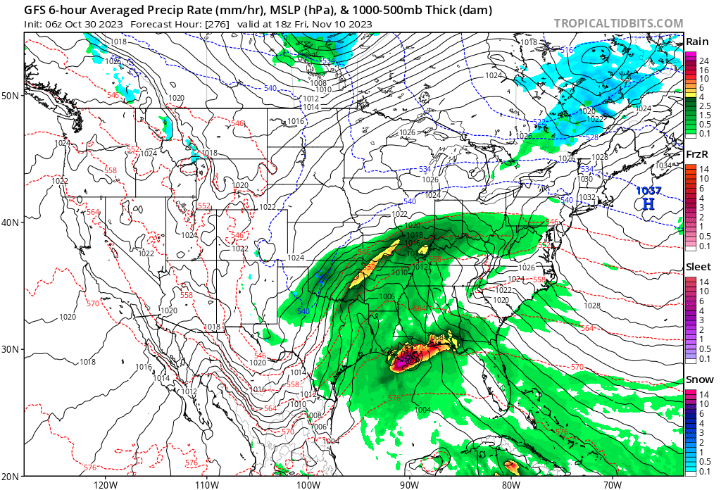
The EC model does not go out quite that far. It does show a developing system around that time, as well.
I will keep an eye on it.

.
Click here if you would like to return to the top of the page.
This outlook covers southeast Missouri, southern Illinois, western Kentucky, and far northwest Tennessee.

.
Today’s Storm Prediction Center’s Severe Weather Outlook
Light green is where thunderstorms may occur but should be below severe levels.
Dark green is a level one risk. Yellow is a level two risk. Orange is a level three (enhanced) risk. Red is a level four (moderate) risk. Pink is a level five (high) risk.
One is the lowest risk. Five is the highest risk.
A severe storm is one that produces 58 mph wind or higher, quarter size hail, and/or a tornado.
Explanation of tables. Click here.

.
Tornado Probability Outlook

.
Large Hail Probability Outlook

.
High wind Probability Outlook

.
Tomorrow’s severe weather outlook.

.
Day Three Severe Weather Outlook

.

.
The images below are from NOAA’s Weather Prediction Center.
24-hour precipitation outlook..
 .
.
.
48-hour precipitation outlook.
. .
.
![]()
_______________________________________
.

Click here if you would like to return to the top of the page.
Again, as a reminder, these are models. They are never 100% accurate. Take the general idea from them.
What should I take from these?
- The general idea and not specifics. Models usually do well with the generalities.
- The time-stamp is located in the upper left corner.
.
What am I looking at?
You are looking at computer model data. Meteorologists use many different models to forecast the weather.
Occasionally, these maps are in Zulu time. 12z=7 AM. 18z=1 PM. 00z=7 PM. 06z=1 AM
Green represents light rain. Dark green represents moderate rain. Yellow and orange represent heavier rain.
.
This animation is the Hrrr Model Future-cast Radar. What radar might look like.
Occasionally, these maps are in Zulu time. 12z=7 AM. 18z=1 PM. 00z=7 PM. 06z=1 AM

.
This animation is the NAM Model.
Occasionally, these maps are in Zulu time. 12z=7 AM. 18z=1 PM. 00z=7 PM. 06z=1 AM
.
..![]()

.
Click here if you would like to return to the top of the page.
.Average high temperatures for this time of the year are around 90 degrees.
Average low temperatures for this time of the year are around 70 degrees.
Average precipitation during this time period ranges from 0.90″ to 1.20″
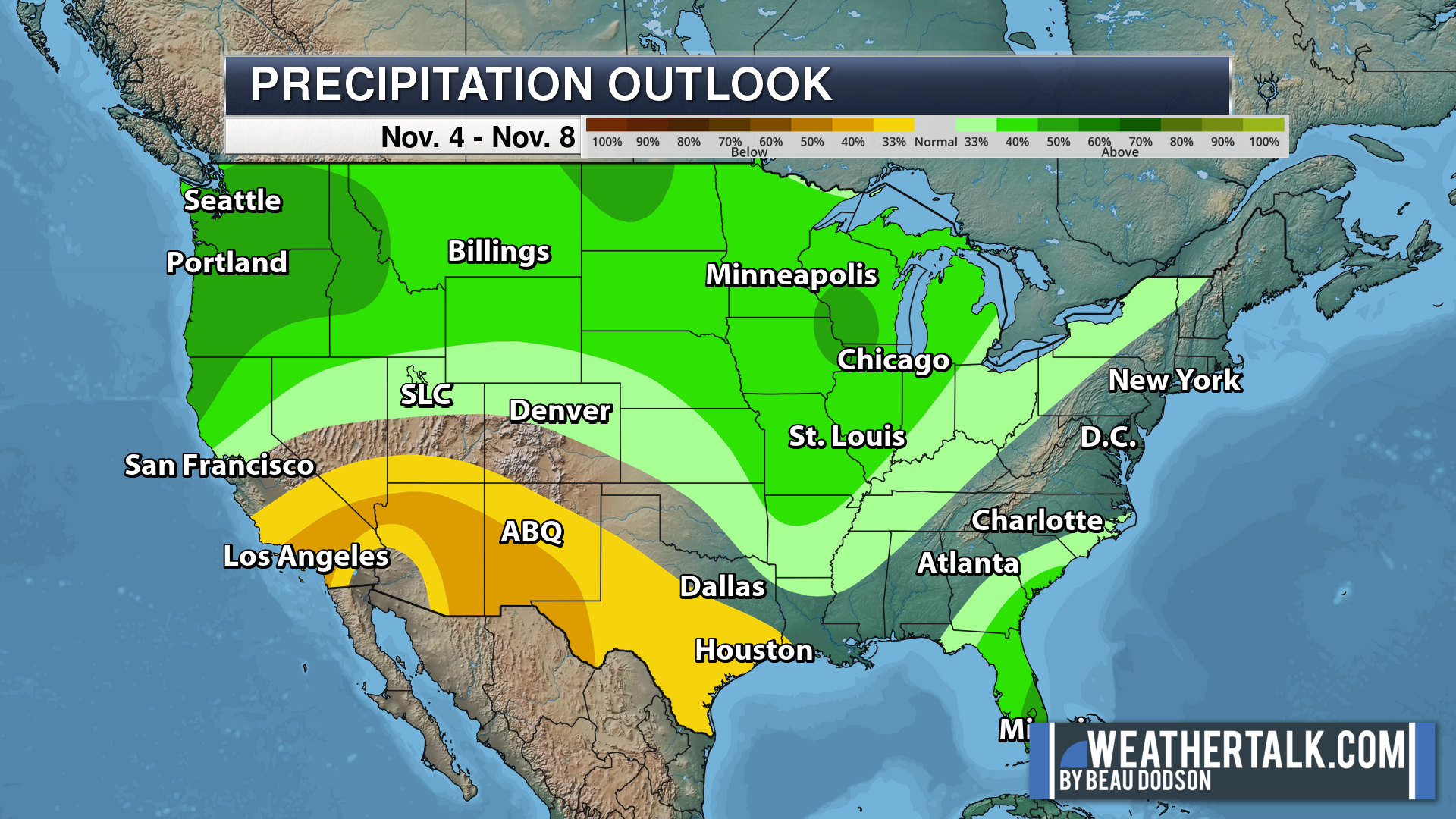
Six to Ten Day Outlook.
Blue is below average. Red is above average. The no color zone represents equal chances.
Average highs for this time of the year are in the lower 60s. Average lows for this time of the year are in the lower 40s.
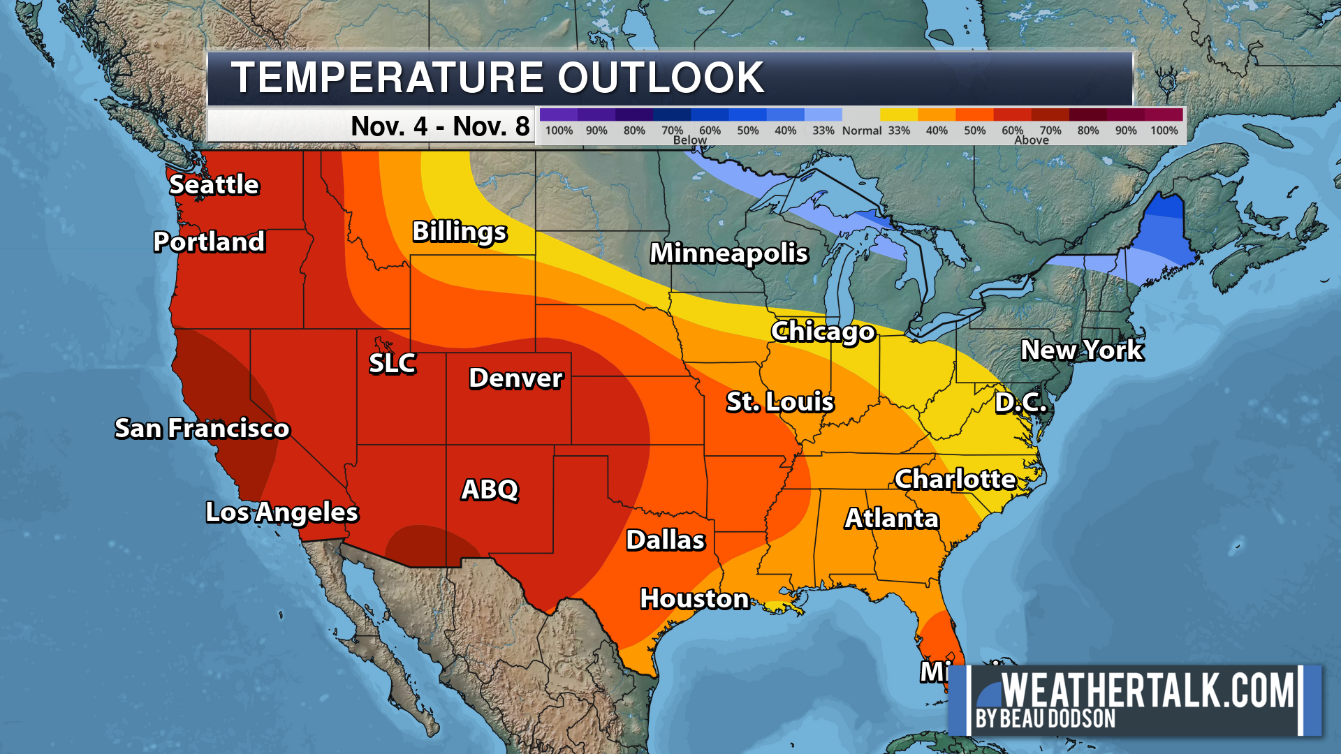
Green is above average precipitation. Yellow and brown favors below average precipitation. Average precipitation for this time of the year is around one inch per week.
.

Average low temperatures for this time of the year are around 70 degrees.
Average precipitation during this time period ranges from 0.90″ to 1.20″
.
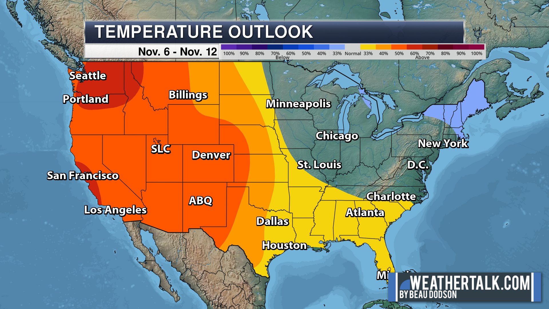
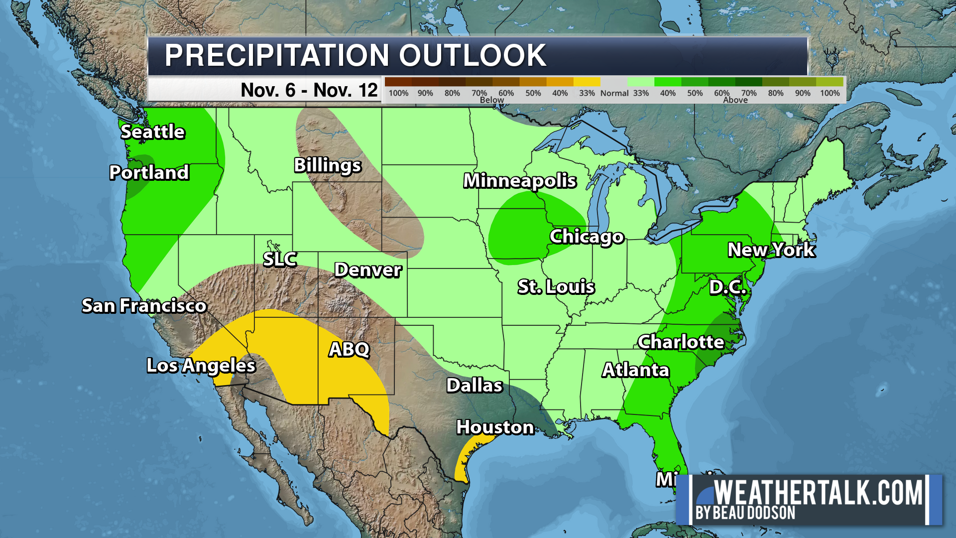
Eight to Fourteen Day Outlook.
Blue is below average. Red is above average. The no color zone represents equal chances.
Green is above average precipitation. Yellow and brown favors below average precipitation. Average precipitation for this time of the year is around one inch per week.
.
![]()
The app is for subscribers. Subscribe at www.weathertalk.com/welcome then go to your app store and search for WeatherTalk
Subscribers, PLEASE USE THE APP. ATT and Verizon are not reliable during severe weather. They are delaying text messages.
The app is under WeatherTalk in the app store.

Apple users click here

Android users click here
.

Radars and Lightning Data
Interactive-city-view radars. Clickable watches and warnings.
https://wtalk.co/B3XHASFZ
If the radar is not updating then try another one. If a radar does not appear to be refreshing then hit Ctrl F5. You may also try restarting your browser.
Backup radar site in case the above one is not working.
https://weathertalk.com/morani
Regional Radar
https://imagery.weathertalk.com/prx/RadarLoop.mp4
** NEW ** Zoom radar with chaser tracking abilities!
ZoomRadar
Lightning Data (zoom in and out of your local area)
https://wtalk.co/WJ3SN5UZ
Not working? Email me at beaudodson@usawx.com
National map of weather watches and warnings. Click here.
Storm Prediction Center. Click here.
Weather Prediction Center. Click here.
.

Live lightning data: Click here.
Real time lightning data (another one) https://map.blitzortung.org/#5.02/37.95/-86.99
Our new Zoom radar with storm chases
.
.

Interactive GOES R satellite. Track clouds. Click here.
GOES 16 slider tool. Click here.
College of DuPage satellites. Click here
.

Here are the latest local river stage forecast numbers Click Here.
Here are the latest lake stage forecast numbers for Kentucky Lake and Lake Barkley Click Here.
.
.
Find Beau on Facebook! Click the banner.


 .
.