
Click one of the links below to take you directly to that section
Do you have any suggestions or comments? Email me at beaudodson@usawx.com
.
.
.
.
We are raising money for teddy bears to donate to Lotus! Consider giving a few dollars and help us meet our goal.
Thank you.
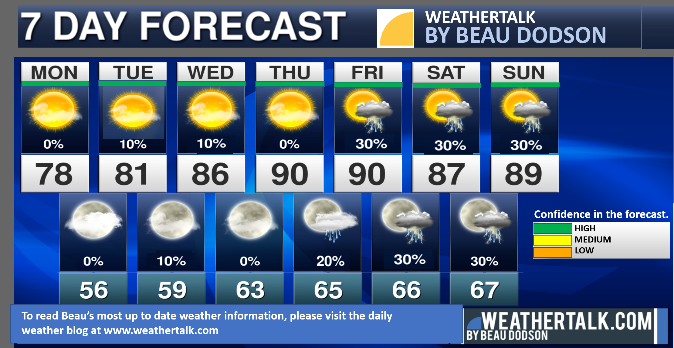
Seven-day forecast for southeast Missouri, southern Illinois, western Kentucky, and western Tennessee.
This is a BLEND for the region. Scroll down to see the region by region forecast.
THE FORECAST IS GOING TO VARY FROM LOCATION TO LOCATION. Scroll down to see the region by region forecast.
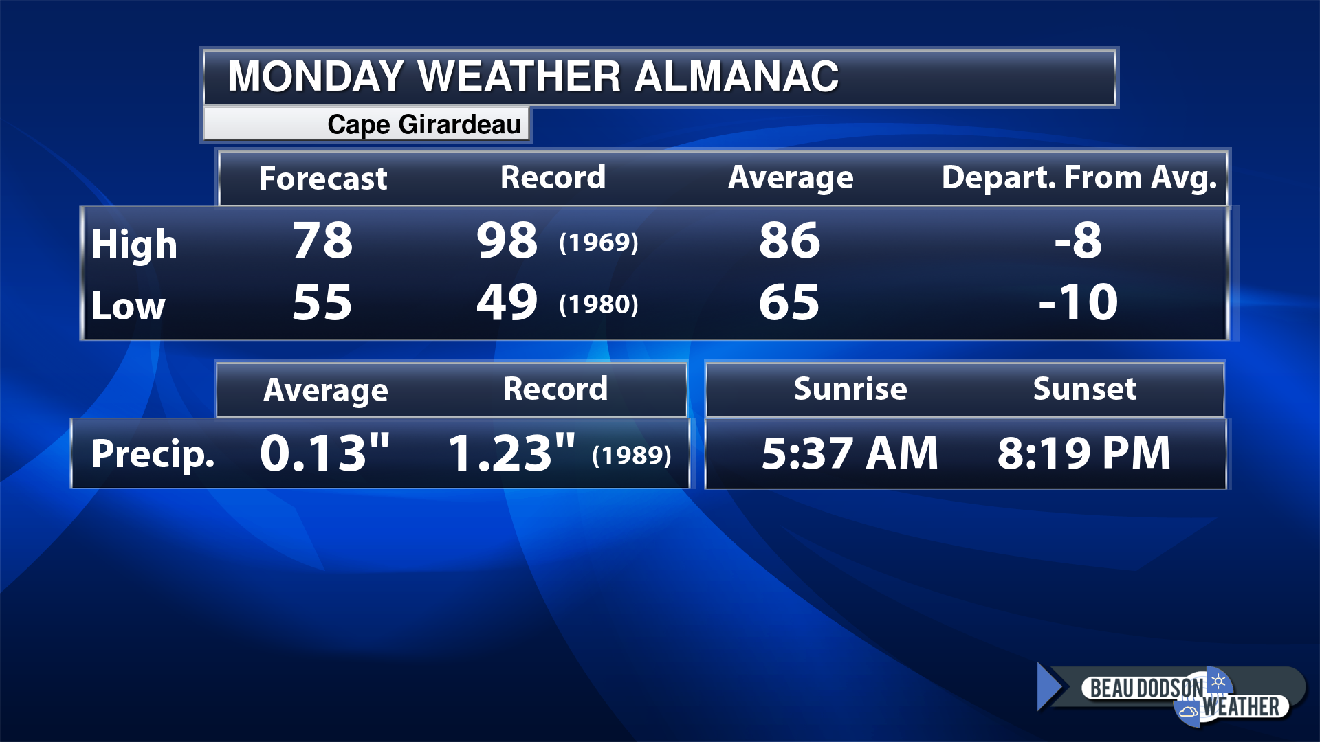
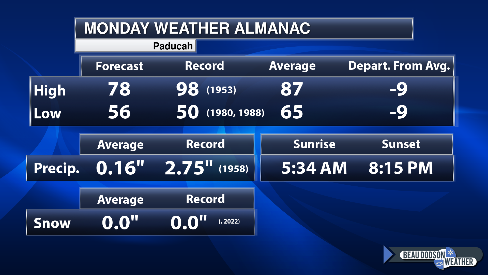
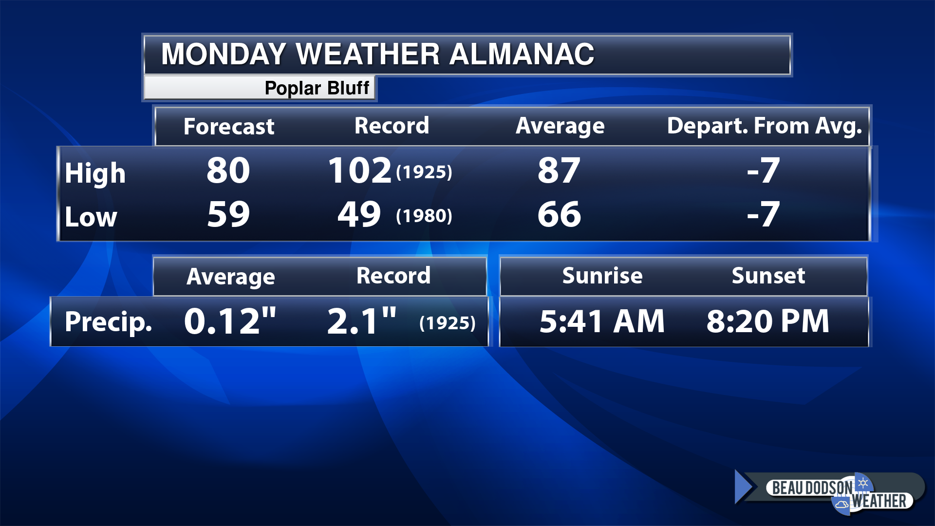
Today’s Local Almanacs (for a few select cities). Your location will be comparable.
Note, the low is this morning’s low and not tomorrows.
Today’s almanac numbers from a few select local cities.
The forecast temperature shows you today’s expected high and this morning’s low.
The graphic shows you the record high and record low for today. It shows you what year that occurred, as well.
It then shows you what today’s average temperature is.
Then, it shows you the departures (how may degrees above or below average temperatures will be ).
It shows you the average precipitation for today. Average comes from thirty years of rain totals.
It also shows you the record rainfall for the date and what year that occurred.
The sunrise and sunset are also shown.
If you have not subscribed to my YouTube Channel then click on this link and it will take you to my videos.
Click the button below and it will take you to the Beau Dodson YouTube Channel.
48-hour forecast


.

.
Monday to Monday
1. Is lightning in the forecast? Yes. I am monitoring Friday through Monday for additional thunderstorm chances.
2. Are severe thunderstorms in the forecast? Possible. Thunderstorms could be intense this coming weekend. For now, I am monitoring the model guidance. There is not a strong signal for severe weather. Monitor updates.
3. Is flash flooding in the forecast? Not at this time. Thunderstorms can briefly produce very heavy downpours. That could briefly cause ponding of water on roadways.
4. Will the heat index exceed 100 degrees? Not at this time.
5. Will the wind chill dip below 10 degrees? No.
6. Is measurable snow and/or sleet in the forecast? No.
7. Is freezing rain/ice in the forecast? No.
Freezing rain is rain that falls and instantly freezes on objects such as trees and power lines
.
.
Monday, June 12, 2023
Confidence in the forecast? High Confidence
Monday Forecast: Morning clouds departing. Becoming mostly sunny. A nice day on tap for the region.
What is the chance of precipitation?
Far northern southeast Missouri ~ 0%
Southeast Missouri ~ 0%
The Missouri Bootheel ~ 0%
I-64 Corridor of southern Illinois ~ 0%
Southern Illinois ~0%
Extreme southern Illinois (southern seven counties) ~ 0%
Far western Kentucky ~ 0%
The Pennyrile area of western KY ~ 0%
Northwest Kentucky (near Indiana border) ~ 0%
Northwest Tennessee ~ 0%
Coverage of precipitation:
Timing of the precipitation:
Temperature range:
Far northern southeast Missouri ~ 75° to 80°
Southeast Missouri ~ 75° to 80°
The Missouri Bootheel ~ 76° to 80°
I-64 Corridor of southern Illinois ~ 76° to 80°
Southern Illinois ~ 76° to 80°
Extreme southern Illinois (southern seven counties) ~ 76° to 80°
Far western Kentucky ~ 76° to 80°
The Pennyrile area of western KY ~ 76° to 80°
Northwest Kentucky (near Indiana border) ~ 76° to 80°
Northwest Tennessee ~ 76° to 80°
Winds will be from this direction: North northwest 8 to 16 mph.
Wind chill or heat index (feels like) temperature forecast: 75° to 80°
What impacts are anticipated from the weather?
Should I cancel my outdoor plans? No
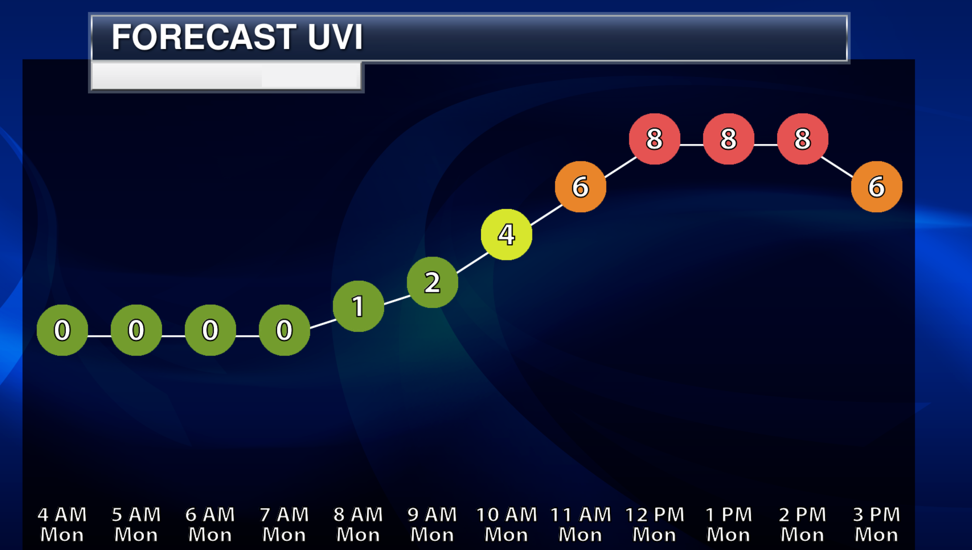
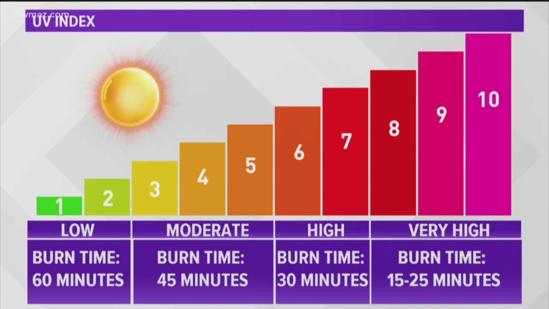
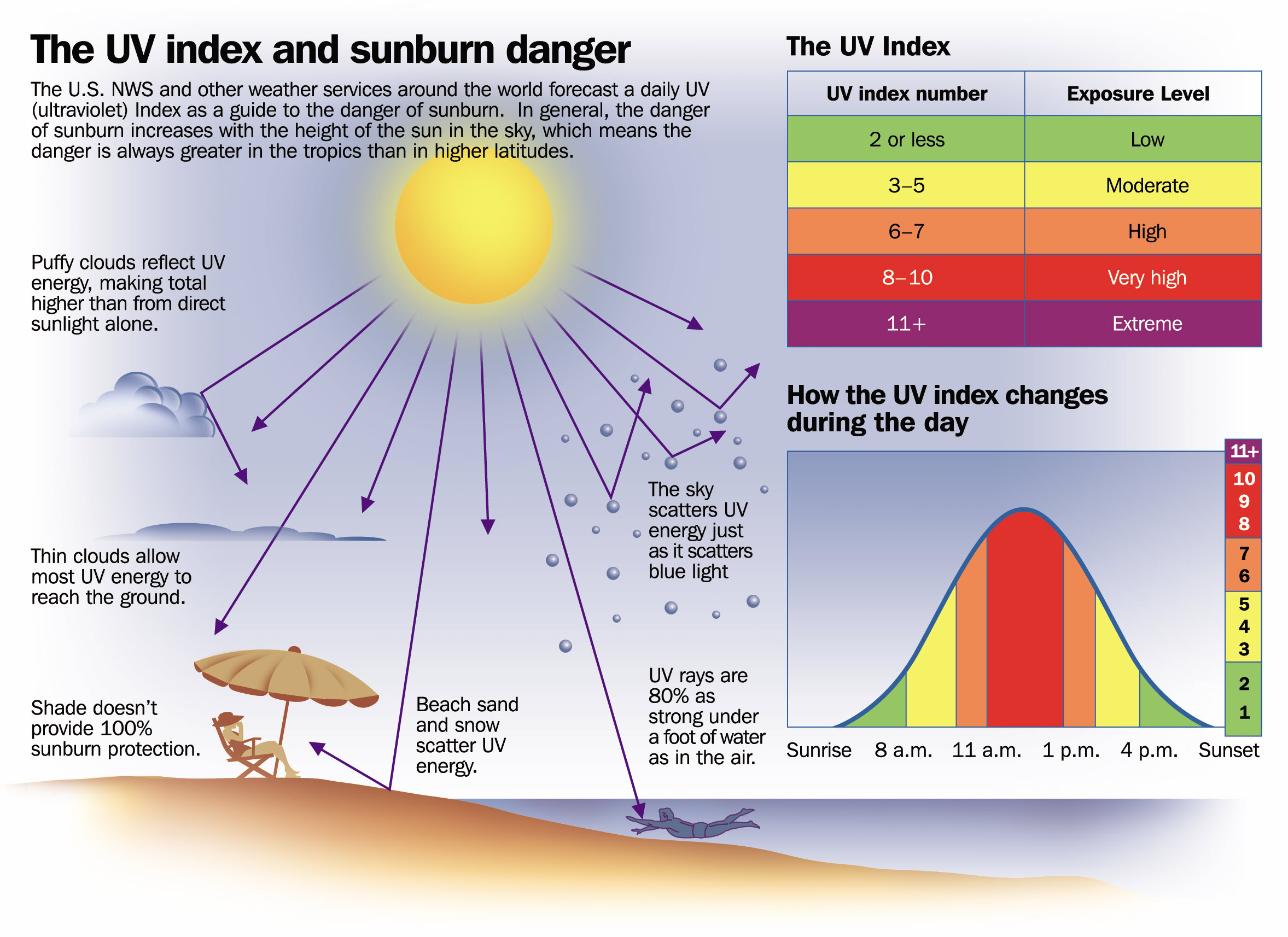
UV Index: 10. Very high.
Sunrise: 5:33 AM
Sunset: 8:15 PM
.
Monday night Forecast: Mostly clear.
What is the chance of precipitation?
Far northern southeast Missouri ~ 0%
Southeast Missouri ~ 6%
The Missouri Bootheel ~ 0%
I-64 Corridor of southern Illinois ~ 0%
Southern Illinois ~0%
Extreme southern Illinois (southern seven counties) ~ 0%
Far western Kentucky ~ 0%
The Pennyrile area of western KY ~ 0%
Northwest Kentucky (near Indiana border) ~ 0%
Northwest Tennessee ~ 0%
Coverage of precipitation:
Timing of the precipitation:
Temperature range:
Far northern southeast Missouri ~ 48° to 52°
Southeast Missouri ~ 52° to 55°
The Missouri Bootheel ~ 54° to 58°
I-64 Corridor of southern Illinois ~ 48° to 52°
Southern Illinois ~ 52° to 54°
Extreme southern Illinois (southern seven counties) ~ 52° to 54°
Far western Kentucky ~ 53° to 56°
The Pennyrile area of western KY ~ 53° to 56°
Northwest Kentucky (near Indiana border) ~ 52° to 54°
Northwest Tennessee ~ 54° to 58°
Winds will be from this direction: Northwest 7 to 14 mph.
Wind chill or heat index (feels like) temperature forecast: 48° to 58°
What impacts are anticipated from the weather?
Should I cancel my outdoor plans?
Moonrise: 2:08 AM
Moonset: 2:53 PM
The phase of the moon: Waning Crescent
.
Tuesday, June 13, 2023
Confidence in the forecast? High Confidence
Tuesday Forecast: Mostly sunny. There will be more clouds over our southern counties vs northern counties. That includes the Missouri Bootheel and along the Kentucky/Tennessee border southward. A slight chance of showers in the Missouri Bootheel and northwest Tennessee. A lower chance north of there.
What is the chance of precipitation?
Far northern southeast Missouri ~ 0%
Southeast Missouri ~ 10%
The Missouri Bootheel ~ 20%
I-64 Corridor of southern Illinois ~ 0%
Southern Illinois ~0%
Extreme southern Illinois (southern seven counties) ~ 0%
Far western Kentucky ~ 10%
The Pennyrile area of western KY ~ 10%
Northwest Kentucky (near Indiana border) ~ 0%
Northwest Tennessee ~ 20%
Coverage of precipitation: Isolated (far south)
Timing of the precipitation: Any given point of time
Temperature range:
Far northern southeast Missouri ~ 80° to 82°
Southeast Missouri ~ 80° to 82°
The Missouri Bootheel ~ 78° to 82°
I-64 Corridor of southern Illinois ~ 80° to 82°
Southern Illinois ~ 80° to 82°
Extreme southern Illinois (southern seven counties) ~ 80° to 82°
Far western Kentucky ~ 80° to 82°
The Pennyrile area of western KY ~ 80° to 82°
Northwest Kentucky (near Indiana border) ~ 80° to 84°
Northwest Tennessee ~ 78° to 82°
Winds will be from this direction: Southwest 7 to 14 mph
Wind chill or heat index (feels like) temperature forecast: 78° to 84°
What impacts are anticipated from the weather? Wet roadways. Lightning.
Should I cancel my outdoor plans? No, but check the Beau Dodson Weather radars.
UV Index: 10. Very high.
Sunrise: 5:33 AM
Sunset: 8:16 PM
.
Tuesday night Forecast: Partly cloudy. A slight chance of showers and thunderstorms (far south)
What is the chance of precipitation?
Far northern southeast Missouri ~ 0%
Southeast Missouri ~ 0%
The Missouri Bootheel ~ 20%
I-64 Corridor of southern Illinois ~ 0%
Southern Illinois ~ 0%
Extreme southern Illinois (southern seven counties) ~ 0%
Far western Kentucky ~ 10%
The Pennyrile area of western KY ~ 10%
Northwest Kentucky (near Indiana border) ~ 0%
Northwest Tennessee ~ 20%
Coverage of precipitation: Isolated
Timing of the precipitation: Any given point of time
Temperature range:
Far northern southeast Missouri ~ 54° to 56°
Southeast Missouri ~ 54° to 58°
The Missouri Bootheel ~ 56° to 60°
I-64 Corridor of southern Illinois ~ 54° to 56°
Southern Illinois ~ 56° to 58°
Extreme southern Illinois (southern seven counties) ~ 56° to 58°
Far western Kentucky ~ 56° to 60°
The Pennyrile area of western KY ~ 56° to 60°
Northwest Kentucky (near Indiana border) ~ 56° to 60°
Northwest Tennessee ~ 56° to 60°
Winds will be from this direction: Southwest 7 to 14 mph
Wind chill or heat index (feels like) temperature forecast: 54° to 60°
What impacts are anticipated from the weather? Wet roadways. Lightning.
Should I cancel my outdoor plans? No.
Moonrise: 2:34 AM
Moonset: 4:00 PM
The phase of the moon: Waning Crescent
.
Wednesday, June 13, 2023
Confidence in the forecast? High Confidence
Wednesday Forecast: Mostly sunny. A slight chance of a shower in the Missouri Bootheel and northwest Tennessee.
What is the chance of precipitation?
Far northern southeast Missouri ~ 0%
Southeast Missouri ~ 0%
The Missouri Bootheel ~ 20%
I-64 Corridor of southern Illinois ~ 0%
Southern Illinois ~ 0%
Extreme southern Illinois (southern seven counties) ~ 0%
Far western Kentucky ~ 0%
The Pennyrile area of western KY ~ 0%
Northwest Kentucky (near Indiana border) ~ 0%
Northwest Tennessee ~ 20%
Coverage of precipitation: Isolated (far south)
Timing of the precipitation: Any given point of time.
Temperature range:
Far northern southeast Missouri ~ 82° to 84°
Southeast Missouri ~ 82° to 84°
The Missouri Bootheel ~ 83° to 86°
I-64 Corridor of southern Illinois ~ 82° to 84°
Southern Illinois ~ 82° to 84°
Extreme southern Illinois (southern seven counties) ~ 82° to 85°
Far western Kentucky ~ 82° to 85°
The Pennyrile area of western KY ~ 83° to 86°
Northwest Kentucky (near Indiana border) ~ 83° to 86°
Northwest Tennessee ~ 83° to 86°
Winds will be from this direction: West southwest 7 to 14 mph
Wind chill or heat index (feels like) temperature forecast: 82° to 86°
What impacts are anticipated from the weather? Wet roadways. Lightning.
Should I cancel my outdoor plans? No
UV Index: 9. Very high.
Sunrise: 5:33 AM
Sunset: 8:17 PM
.
Wednesday night Forecast: A few clouds, otherwise mostly clear.
What is the chance of precipitation?
Far northern southeast Missouri ~ 0%
Southeast Missouri ~ 0%
The Missouri Bootheel ~ 0%
I-64 Corridor of southern Illinois ~ 0%
Southern Illinois ~ 0%
Extreme southern Illinois (southern seven counties) ~ 0%
Far western Kentucky ~ 0%
The Pennyrile area of western KY ~ 0%
Northwest Kentucky (near Indiana border) ~ 0%
Northwest Tennessee ~ 0%
Coverage of precipitation:
Timing of the precipitation:
Temperature range:
Far northern southeast Missouri ~ 56° to 58°
Southeast Missouri ~ 58° to 62°
The Missouri Bootheel ~ 60° to 64°
I-64 Corridor of southern Illinois ~ 58° to 62°
Southern Illinois ~ 60° to 62°
Extreme southern Illinois (southern seven counties) ~ 62° to 65°
Far western Kentucky ~ 62° to 65°
The Pennyrile area of western KY ~ 62° to 65°
Northwest Kentucky (near Indiana border) ~ 60° to 64°
Northwest Tennessee ~ 62° to 65°
Winds will be from this direction: Southwest 7 to 14 mph
Wind chill or heat index (feels like) temperature forecast: 58° to 65°
What impacts are anticipated from the weather?
Should I cancel my outdoor plans? No
Moonrise: 3:01 AM
Moonset: 5:06 PM
The phase of the moon: Waning Crescent
.
Thursday, June 14, 2023
Confidence in the forecast? High Confidence
Thursday Forecast: Mostly sunny.
What is the chance of precipitation?
Far northern southeast Missouri ~ 0%
Southeast Missouri ~ 0%
The Missouri Bootheel ~ 0%
I-64 Corridor of southern Illinois ~ 0%
Southern Illinois ~ 0%
Extreme southern Illinois (southern seven counties) ~ 0%
Far western Kentucky ~ 0%
The Pennyrile area of western KY ~ 0%
Northwest Kentucky (near Indiana border) ~ 0%
Northwest Tennessee ~ 0%
Coverage of precipitation:
Timing of the precipitation:
Temperature range:
Far northern southeast Missouri ~ 88° to 90°
Southeast Missouri ~ 88° to 90°
The Missouri Bootheel ~ 88° to 90°
I-64 Corridor of southern Illinois ~ 88° to 90°
Southern Illinois ~ 88° to 90°
Extreme southern Illinois (southern seven counties) ~ 88° to 90°
Far western Kentucky ~ 88° to 90°
The Pennyrile area of western KY ~ 88° to 90°
Northwest Kentucky (near Indiana border) ~ 88° to 90°
Northwest Tennessee ~ 88° to 90°
Winds will be from this direction: Southwest 6 to 12 mph
Wind chill or heat index (feels like) temperature forecast: 88° to 90°
What impacts are anticipated from the weather?
Should I cancel my outdoor plans? No
UV Index: 11. Very high.
Sunrise: 5:34 AM
Sunset: 8:18 PM
.
Thursday night Forecast: Partly cloudy.
What is the chance of precipitation?
Far northern southeast Missouri ~ 0%
Southeast Missouri ~ 0%
The Missouri Bootheel ~ 0%
I-64 Corridor of southern Illinois ~ 0%
Southern Illinois ~ 0%
Extreme southern Illinois (southern seven counties) ~ 0%
Far western Kentucky ~ 0%
The Pennyrile area of western KY ~ 0%
Northwest Kentucky (near Indiana border) ~ 0%
Northwest Tennessee ~ 0%
Coverage of precipitation:
Timing of the precipitation:
Temperature range:
Far northern southeast Missouri ~ 60° to 62°
Southeast Missouri ~ 62° to 64°
The Missouri Bootheel ~ 63° to 66°
I-64 Corridor of southern Illinois ~ 60° to 62°
Southern Illinois ~ 62° to 64°
Extreme southern Illinois (southern seven counties) ~ 62° to 65°
Far western Kentucky ~ 63° to 66°
The Pennyrile area of western KY ~ 63° to 66°
Northwest Kentucky (near Indiana border) ~ 63° to 66°
Northwest Tennessee ~ 63° to 66°
Winds will be from this direction: South 6 to 12 mph
Wind chill or heat index (feels like) temperature forecast: 60° to 66°
What impacts are anticipated from the weather?
Should I cancel my outdoor plans? No
Moonrise: 3:31 AM
Moonset: 6:14 PM
The phase of the moon: Waning Crescent
Click here if you would like to return to the top of the page.
-
- Showers and thunderstorms moved across the region Sunday. Some locations received much needed rainfall.
- Weather pattern shifting.
- Widespread rain to our south mid-week. May clip our region (esp southern counties).
Weather advice:
Make sure you have three to five ways of receiving your severe weather information.
Don’t forget the sunscreen on this summer warm days!
.
Forecast Discussion
Today’s Forecast Numbers
Monitoring rain chances over the coming two weeks.
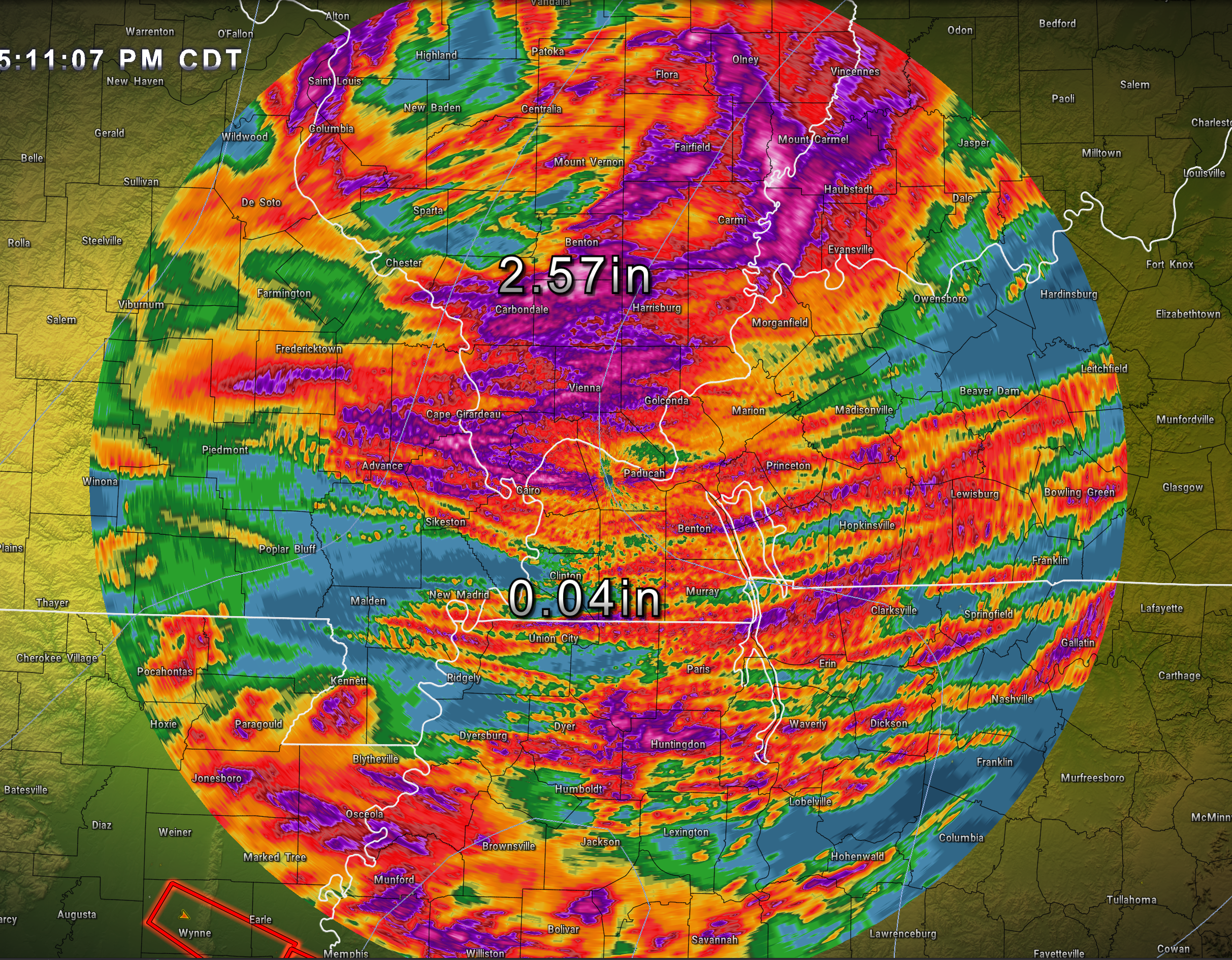
Widespread/much needed rain fell over the region Sunday and Sunday evening. Some of the rain was heavy. There were reports of greater than 2.7″ in some counties.
A widespread 0.3″ to 0.6″ fell with numerous locations receiving 0.6″ to 1.2″. Then, there were pockets of 1.2″ to 2.0+ inches.
Other locations, unfortunately, did not receive nearly as much rain. That was the forecast. Some locations would not receive much.
Here is a radar image of radar indicated rain totals. Again, there were LARGE differences even within counties.
Warm season rain events are often like that. Hit and miss when it comes to totals. Totals are greatly enhanced by thunderstorms. Thunderstorms can easily double your rain totals in a short amount of time.
We do have additional rain chances in the forecast.
As mentioned in previous posts, my greatest concern for the Tuesday/Wednesday and Thursday rain events has been just how far south the rain would track.
It continues to appear as if the greatest rain totals, during the Tuesday/Wednesday and Thursday time-frame, will be across Arkansas, Tennessee, and the southlands.
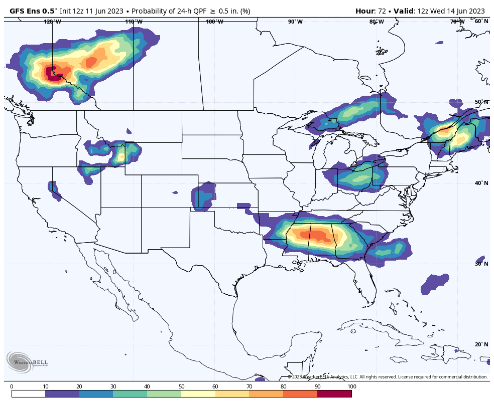
What is the probability of 0.50″ or greater of rain falling Tuesday night into Wednesday.
You can see that it is centered to our south.
The WPC also has the highest totals in that area. The WPC is a branch of NOAA/NWS.
Our region may be clipped by the Tuesday through Thursday rain events.
I do have very low-end rain chances in the forecast, during this time frame, over our far southern counties. The highest probabilities will be across the Missouri Bootheel into western Tennessee. Rain probabilities decrease as you travel farther north.
Even across the Bootheel and northwest Tennessee, the chance of rain will be low (don’t expect much).
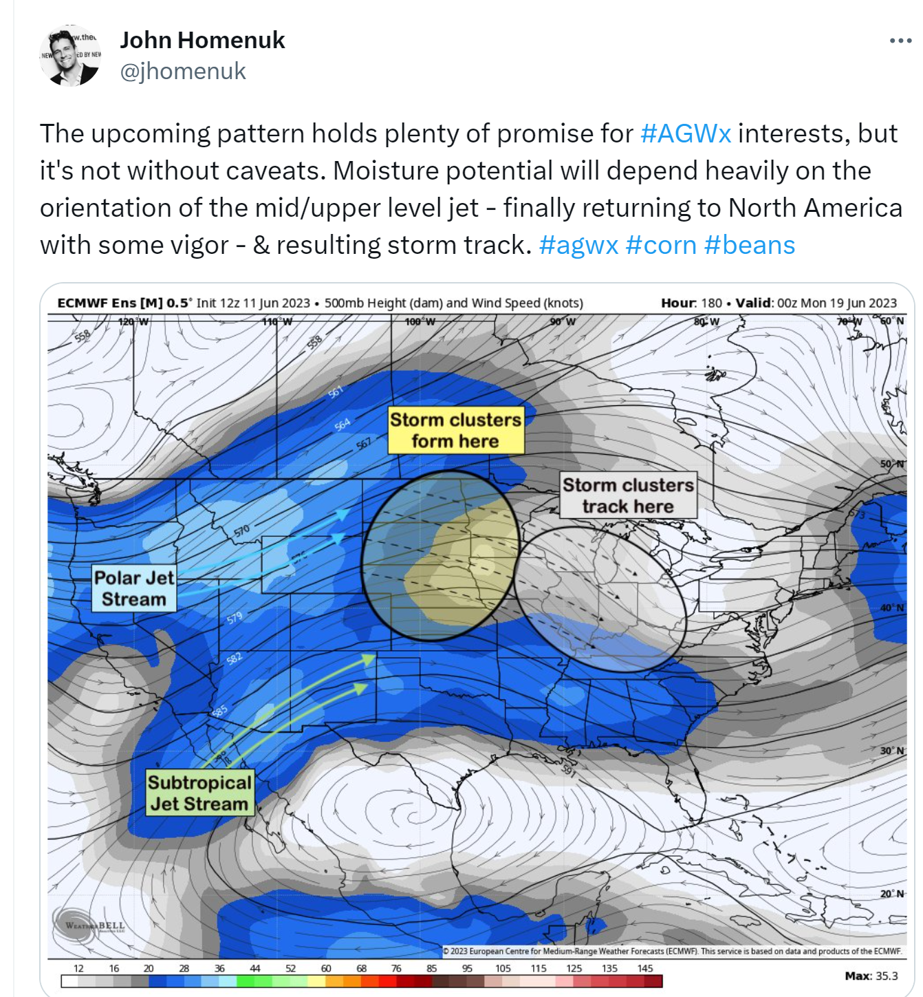
Our next chance of rain will arrive with some northwest jet-stream flow events.
What is northwest flow? That is when the jet-stream dives down from Canada and the Northern Plains. It then pushes southeast into our region.
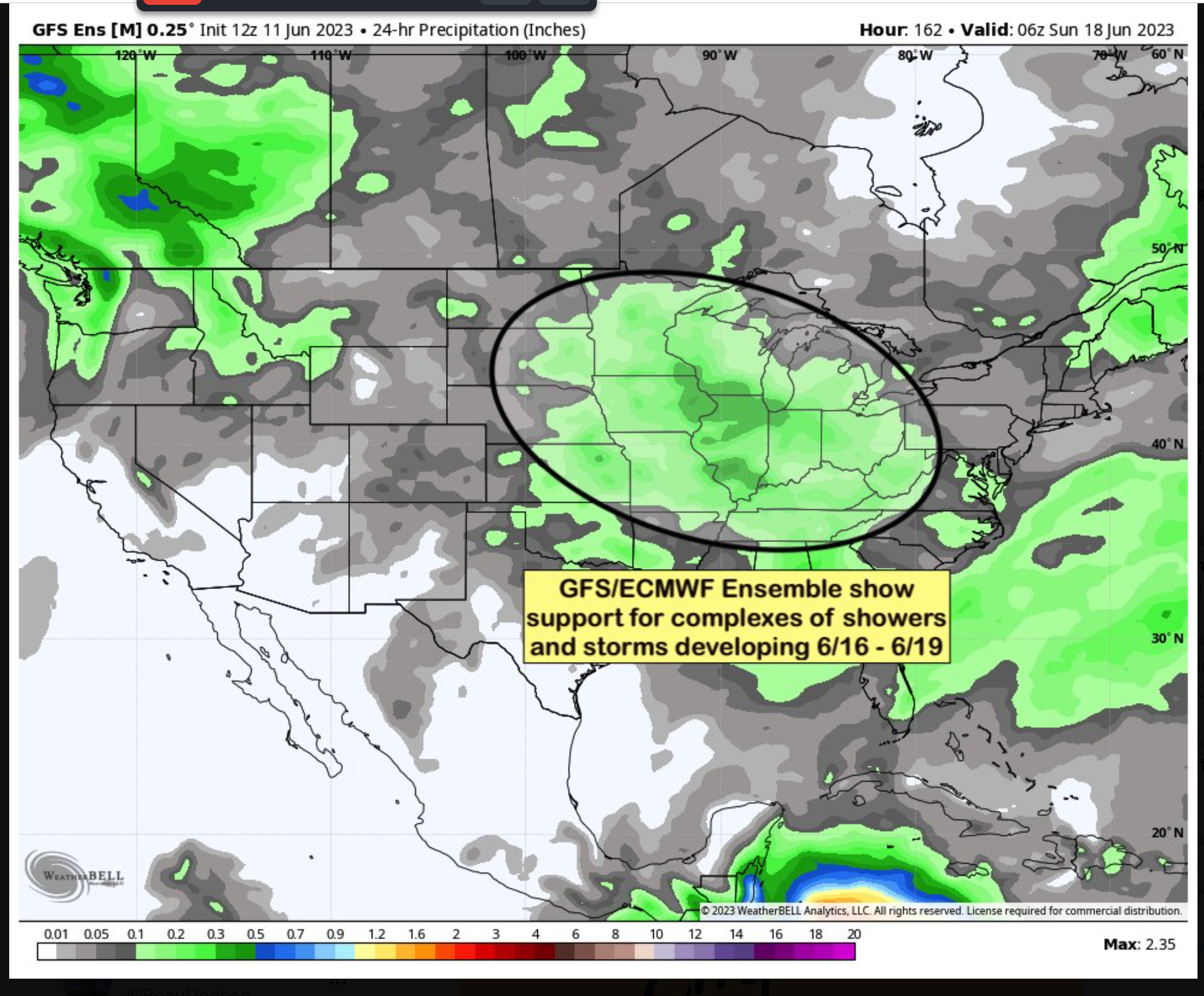
During the summer months, this can produce MCS’s. Thunderstorm complexes.
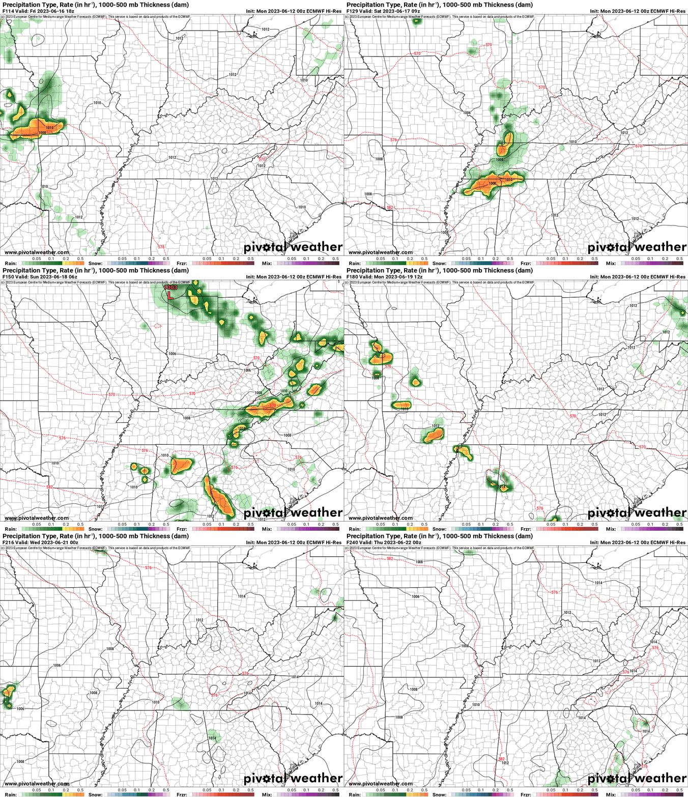
The chance of rain will be with us into the weekend. I am going to have to fine-tune the exact timing of storm complexes and their exact track.
Each track should be a bit slightly different. The track is key to who receives much needed rainfall.
The good news is that the pattern has completely broken down and changed across North America. The big omega block, which kept us very dry, is gone.
We now have better chances of receiving measurable rainfall. It will just be a matter of tracking each system.
Let’s look at some data. Don’t get too caught up in the exact details of each system (this far out). I look at the general overall pattern.
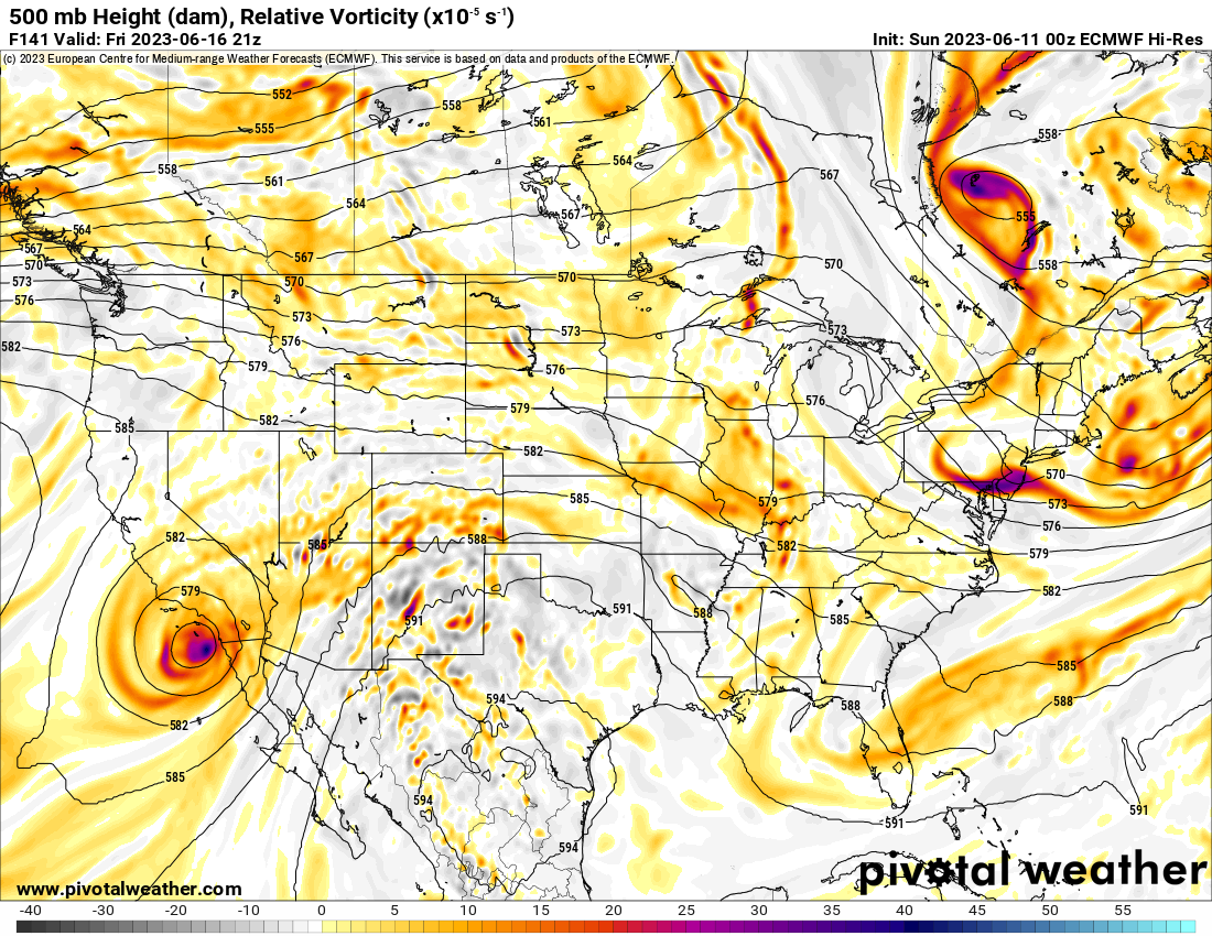
The EC model shows a system this coming Friday moving in from the northwest.
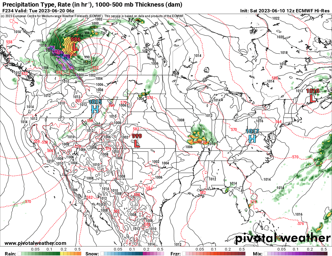
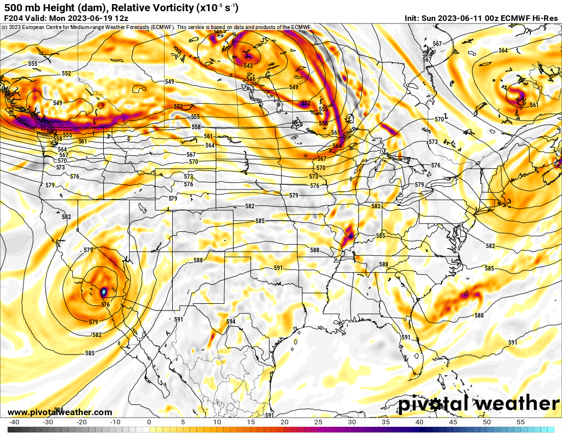
The EC model shows a system next Monday/Tuesday coming in from the northwest.
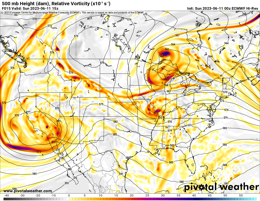
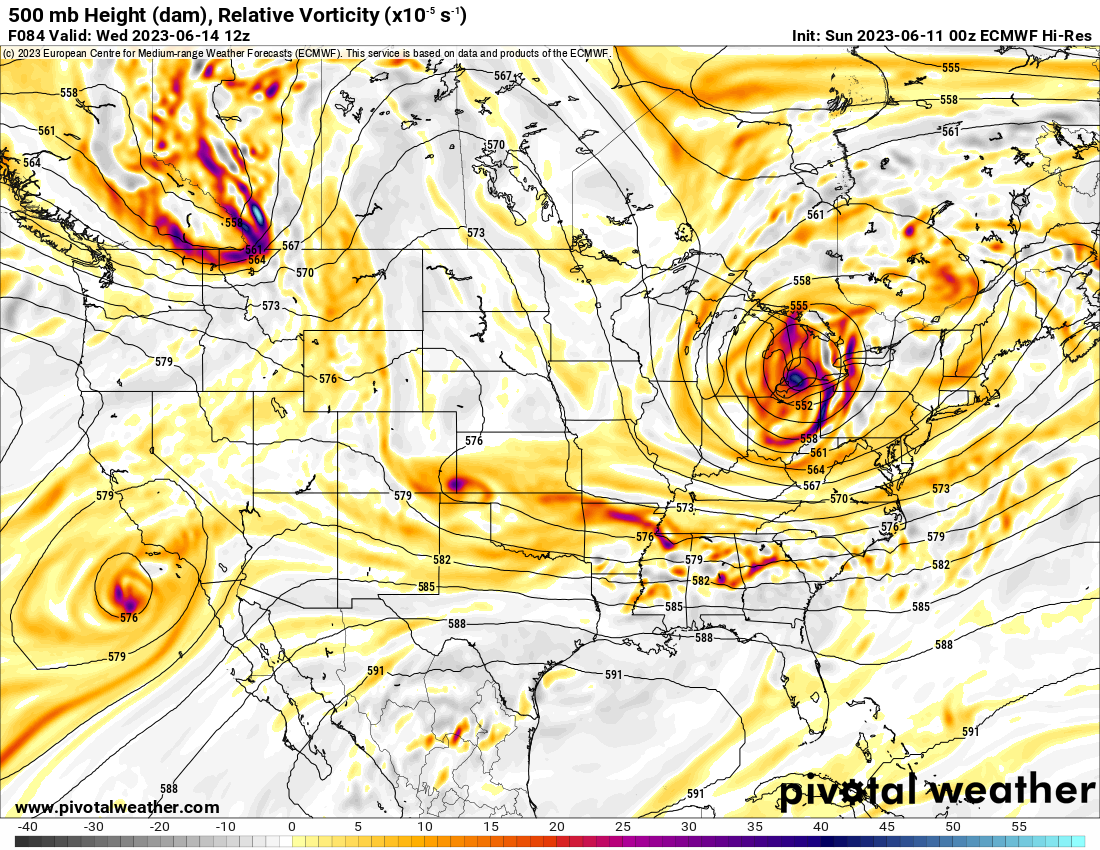
Let’s look at some 500 mb vorticity charts.
Vorticity charts show where lift is located. Storm systems that might produce rain.
For example, here was the Sunday system (yesterday’s system).
See the bright red colors over our region? That is the system that brought our much needed rainfall.
.
Here is the Tuesday/Wednesday system. Mainly to our south.
.
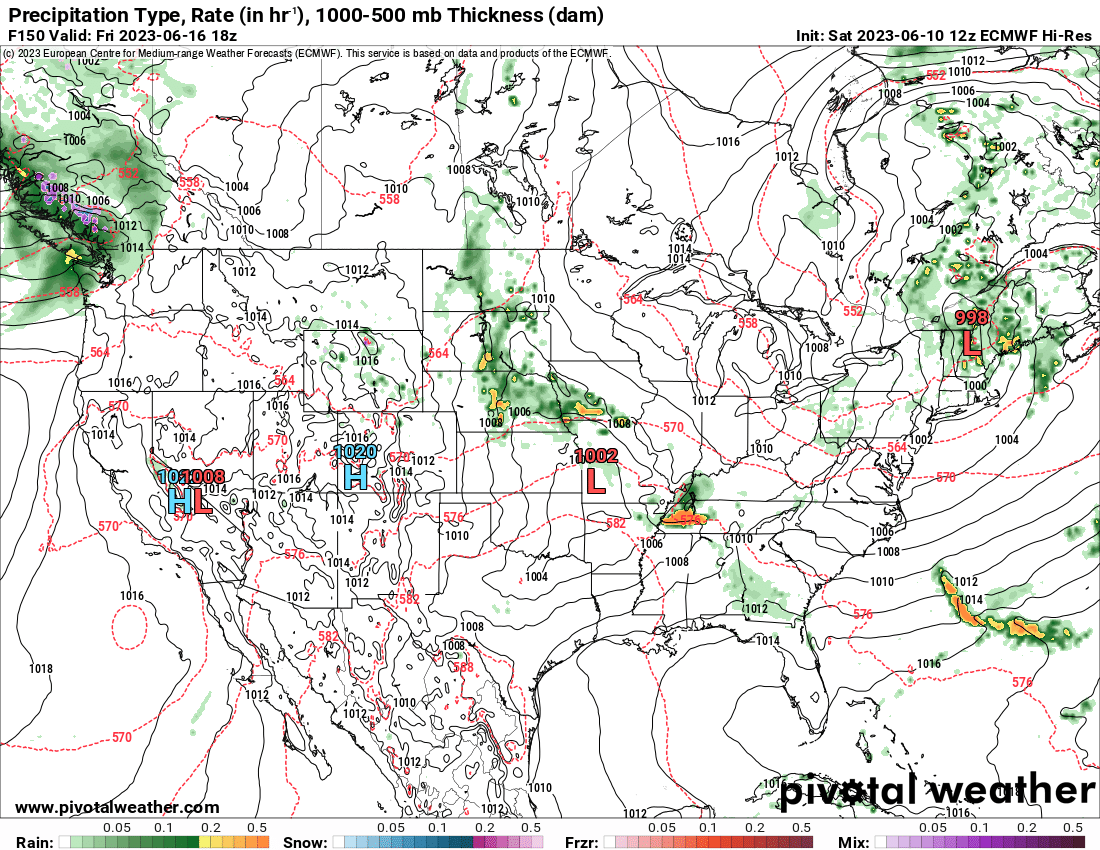
Here is the Friday system on the EC model guidance.
.
Here is the system next Monday/Tuesday
The systems are difficult to forecast days in advance. Often times, these MCS (thunderstorm complexes) are difficult to forecast event the day of the events.
I will be monitoring the data and updating the forecast accordingly. Hopefully, we receive some rain over the coming weeks. That will help the gardeners and farmers.
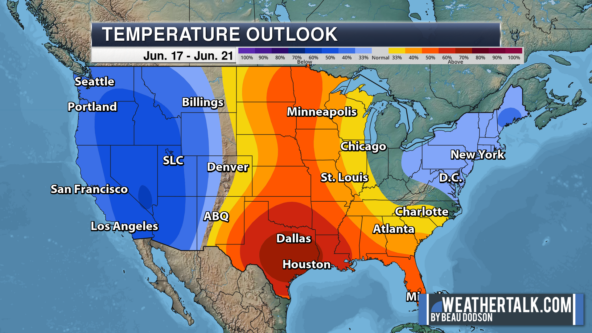
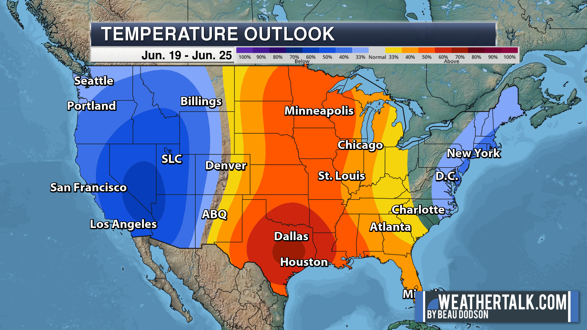
Temperatures will be seasonably warm over the coming seven to fourteen days.
.
Click here if you would like to return to the top of the page.
This outlook covers southeast Missouri, southern Illinois, western Kentucky, and far northwest Tennessee.
Today through April 18th: A couple of the Saturday afternoon and night thunderstorms could produce damaging wind and hail. The tornado risk is low, but not zero. Mainly over Missouri for the tornado risk. The line will weaken with time as it moves farther east.
.
Today’s Storm Prediction Center’s Severe Weather Outlook
Light green is where thunderstorms may occur but should be below severe levels.
Dark green is a level one risk. Yellow is a level two risk. Orange is a level three (enhanced) risk. Red is a level four (moderate) risk. Pink is a level five (high) risk.
One is the lowest risk. Five is the highest risk.
A severe storm is one that produces 58 mph wind or higher, quarter size hail, and/or a tornado.
Explanation of tables. Click here.

.
Tornado Probability Outlook

.
Large Hail Probability Outlook

.
High wind Probability Outlook

.
Tomorrow’s severe weather outlook.

.
Day Three Severe Weather Outlook

.

.
The images below are from NOAA’s Weather Prediction Center.
24-hour precipitation outlook..
 .
.
.
48-hour precipitation outlook.
. .
.
![]()
_______________________________________
.

Click here if you would like to return to the top of the page.
Again, as a reminder, these are models. They are never 100% accurate. Take the general idea from them.
What should I take from these?
- The general idea and not specifics. Models usually do well with the generalities.
- The time-stamp is located in the upper left corner.
.
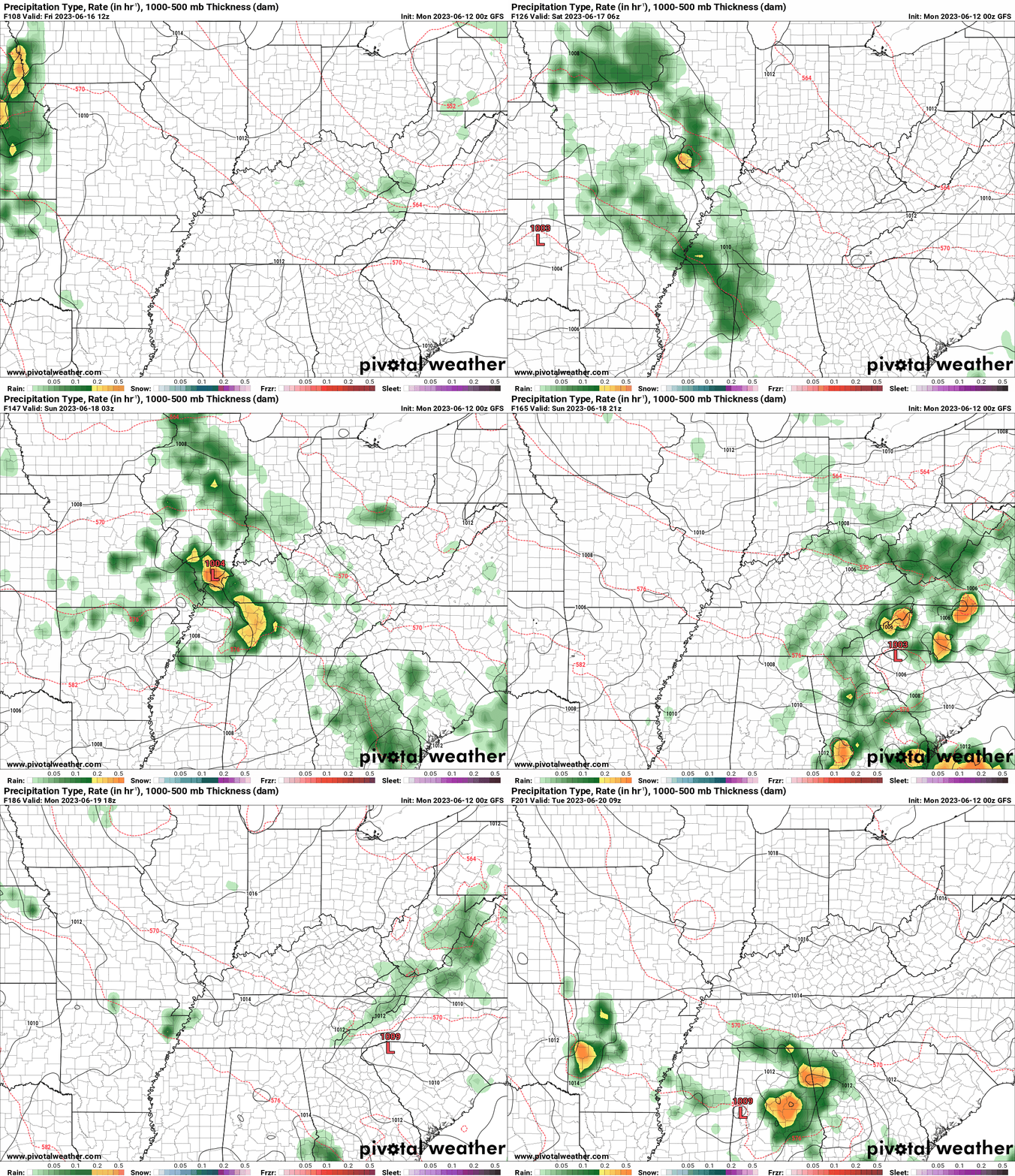
What am I looking at?
You are looking at computer model data. Meteorologists use many different models to forecast the weather.
Occasionally, these maps are in Zulu time. 12z=7 AM. 18z=1 PM. 00z=7 PM. 06z=1 AM
Green represents light rain. Dark green represents moderate rain. Yellow and orange represent heavier rain.
This animation is the SPC WRFModel.
.
This animation is the EC Model.
Occasionally, these maps are in Zulu time. 12z=7 AM. 18z=1 PM. 00z=7 PM. 06z=1 AM
.
This animation is the GFS Model.
Occasionally, these maps are in Zulu time. 12z=7 AM. 18z=1 PM. 00z=7 PM. 06z=1 AM
.
.
..![]()

.
Click here if you would like to return to the top of the page.
.Average high temperatures for this time of the year are around 81 degrees.
Average low temperatures for this time of the year are around 60 degrees.
Average precipitation during this time period ranges from 0.80″ to 1.00″
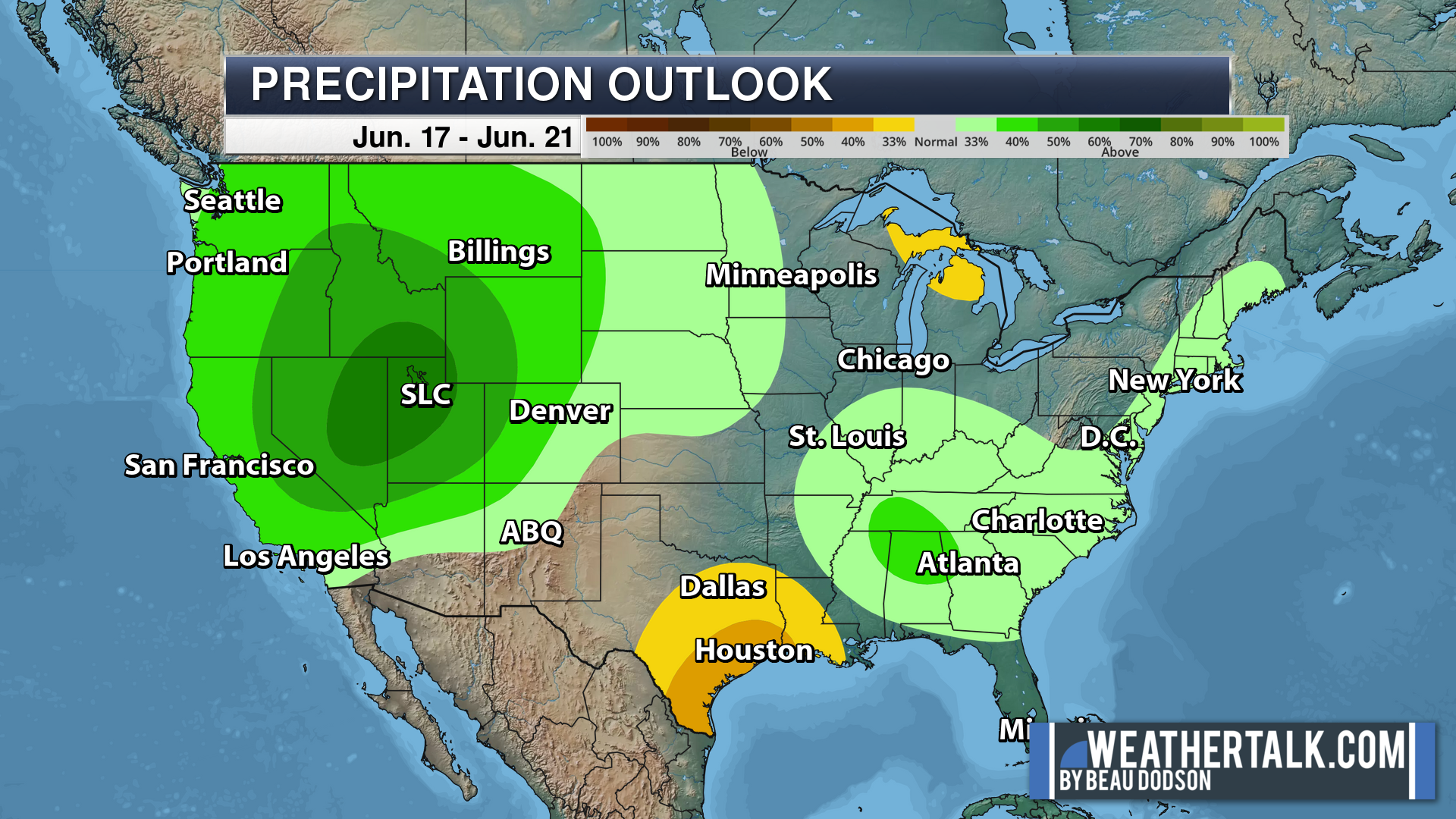
Six to Ten Day Outlook.
Blue is below average. Red is above average. The no color zone represents equal chances.
Average highs for this time of the year are in the lower 60s. Average lows for this time of the year are in the lower 40s.
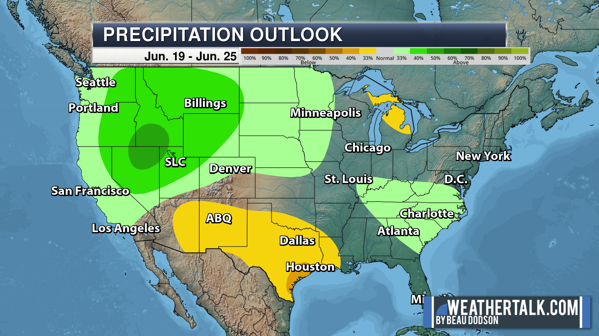
Green is above average precipitation. Yellow and brown favors below average precipitation. Average precipitation for this time of the year is around one inch per week.
.

Average low temperatures for this time of the year are around 62 degrees.
Average precipitation during this time period ranges from 0.80″ to 1.00″
.
.
![]()
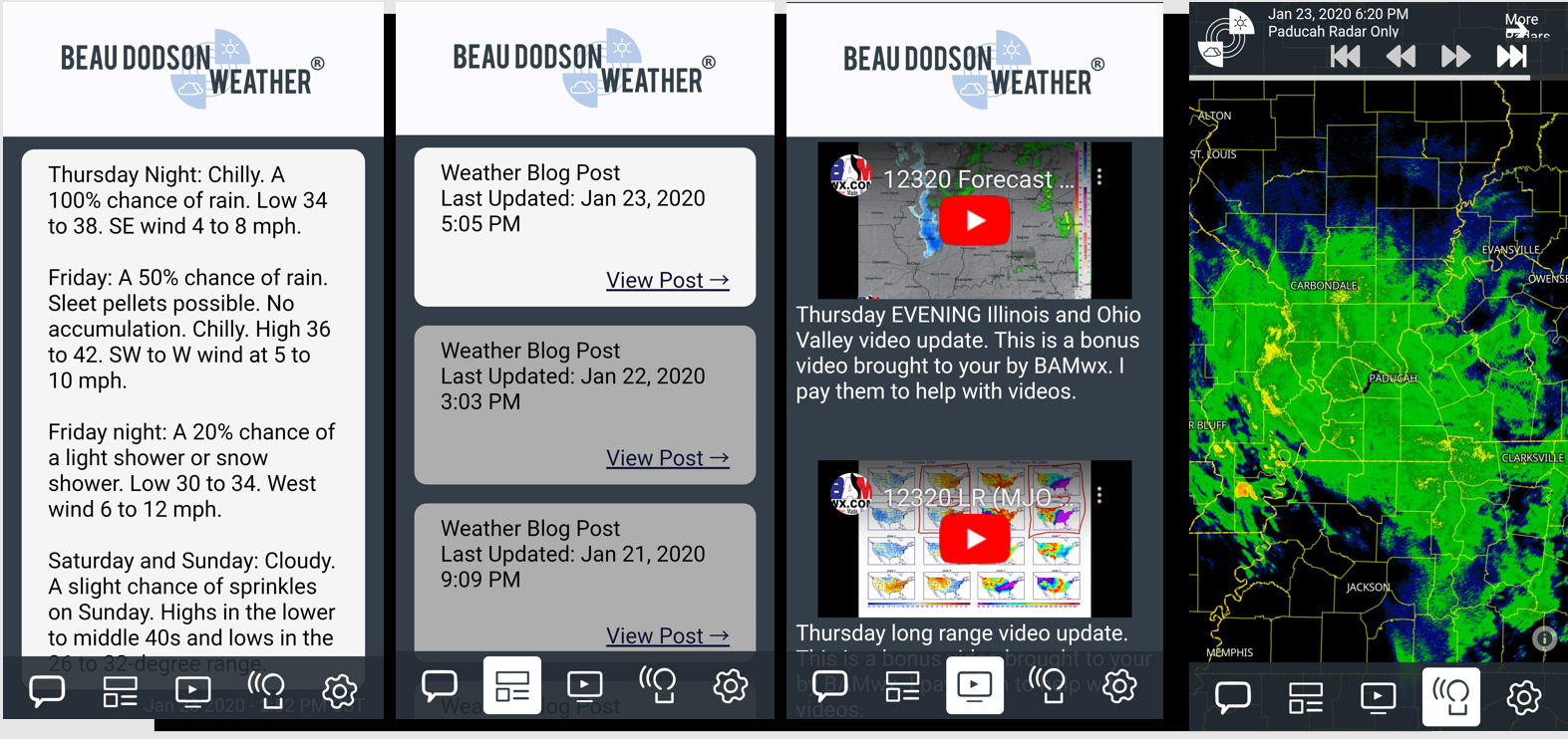
The app is for subscribers. Subscribe at www.weathertalk.com/welcome then go to your app store and search for WeatherTalk
Subscribers, PLEASE USE THE APP. ATT and Verizon are not reliable during severe weather. They are delaying text messages.
The app is under WeatherTalk in the app store.
Apple users click here
Android users click here
.

Radars and Lightning Data
Interactive-city-view radars. Clickable watches and warnings.
https://wtalk.co/B3XHASFZ
If the radar is not updating then try another one. If a radar does not appear to be refreshing then hit Ctrl F5. You may also try restarting your browser.
Backup radar site in case the above one is not working.
https://weathertalk.com/morani
Regional Radar
https://imagery.weathertalk.com/prx/RadarLoop.mp4
** NEW ** Zoom radar with chaser tracking abilities!
ZoomRadar
Lightning Data (zoom in and out of your local area)
https://wtalk.co/WJ3SN5UZ
Not working? Email me at beaudodson@usawx.com
National map of weather watches and warnings. Click here.
Storm Prediction Center. Click here.
Weather Prediction Center. Click here.
.

Live lightning data: Click here.
Real time lightning data (another one) https://map.blitzortung.org/#5.02/37.95/-86.99
Our new Zoom radar with storm chases
.
.

Interactive GOES R satellite. Track clouds. Click here.
GOES 16 slider tool. Click here.
College of DuPage satellites. Click here
.

Here are the latest local river stage forecast numbers Click Here.
Here are the latest lake stage forecast numbers for Kentucky Lake and Lake Barkley Click Here.
.
.
Find Beau on Facebook! Click the banner.









 .
.