
Click one of the links below to take you directly to that section
Do you have any suggestions or comments? Email me at beaudodson@usawx.com
.
.
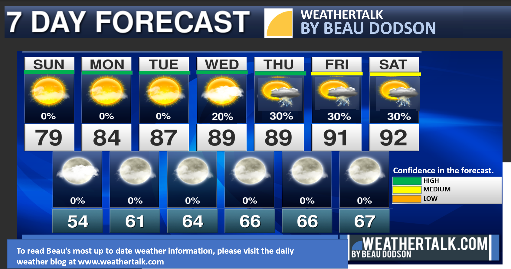
Seven-day forecast for southeast Missouri, southern Illinois, western Kentucky, and western Tennessee.
This is a BLEND for the region. Scroll down to see the region by region forecast.
THE FORECAST IS GOING TO VARY FROM LOCATION TO LOCATION. Scroll down to see the region by region forecast.
There could be some days without the blog this coming week. I am having surgery Tuesday afternoon. It is for Cancer of the bladder.
I appreciate all the emails and texts/messages sending prayers and good thoughts my way. Thank you.
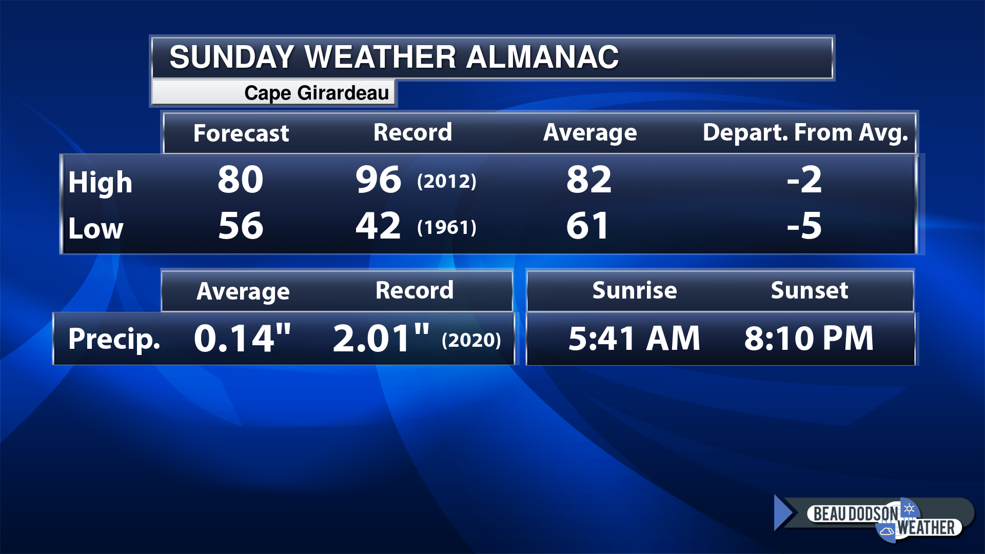
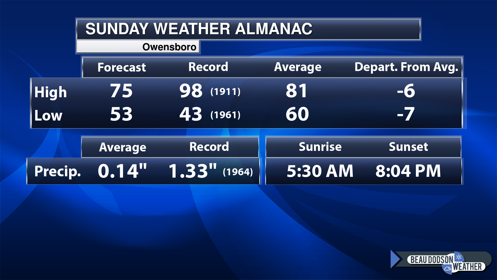
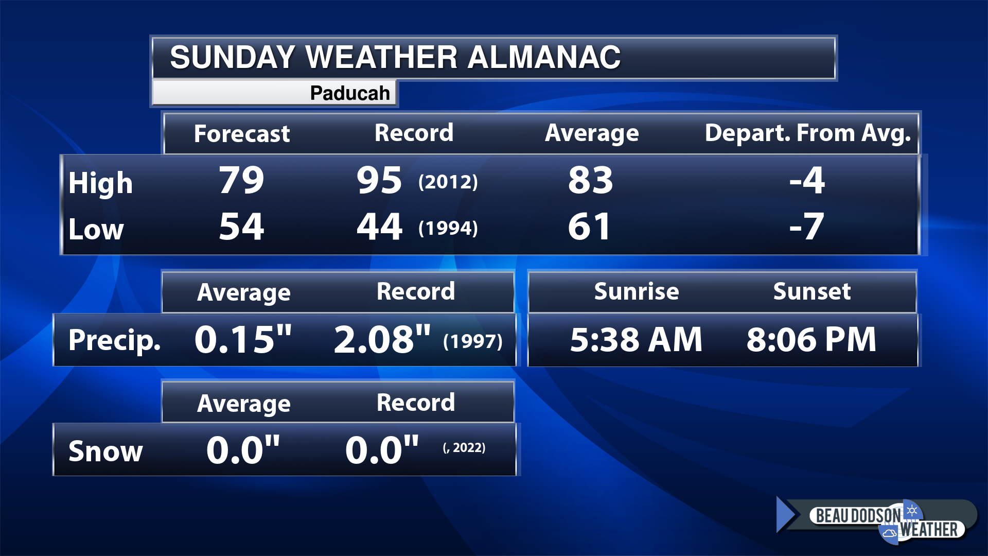
Today’s Local Almanacs (for a few select cities). Your location will be comparable.
Note, the low is this morning’s low and not tomorrows.
If you have not subscribed to my YouTube Channel then click on this link and it will take you to my videos.
Click the button below and it will take you to the Beau Dodson YouTube Channel.
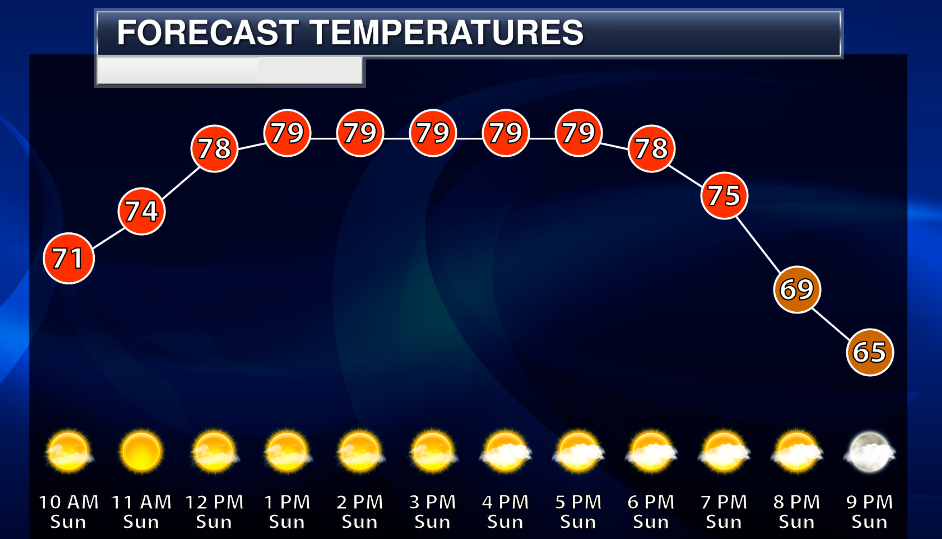
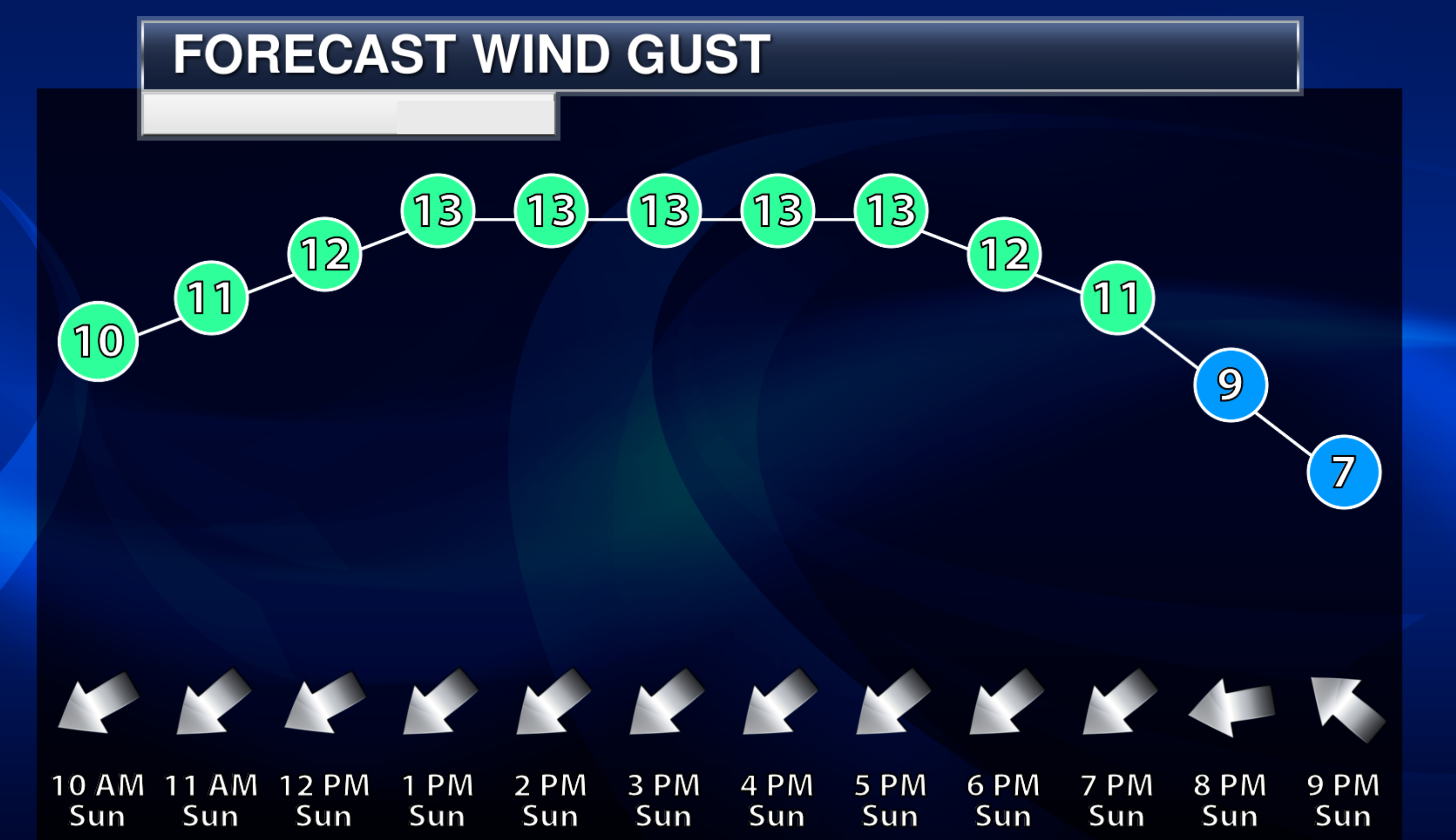
48-hour forecast


.

.
Sunday to Sunday
1. Is lightning in the forecast? Scattered. A chance of lightning Wednesday through Saturday. Higher chances Friday and Saturday vs Wednesday/Thursday.
2. Are severe thunderstorms in the forecast? Not at this time. Monitor updates.
3. Is flash flooding in the forecast? No.
4. Will the heat index exceed 100 degrees? Not at this time.
5. Will the wind chill dip below 10 degrees? No.
6. Is measurable snow and/or sleet in the forecast? No.
7. Is freezing rain/ice in the forecast? No.
Freezing rain is rain that falls and instantly freezes on objects such as trees and power lines
.
Sunday, May 28, 2023
Confidence in the forecast? High Confidence
Sunday Forecast: Mostly sunny. A few passing clouds. A few more clouds over our eastern counties (mainly the Pennryrile area of western Kentucky and northwest Kentucky. Clouds will approach from the east moving west. Mild.
What is the chance of precipitation?
Far northern southeast Missouri ~ 0%
Southeast Missouri ~ 0%
The Missouri Bootheel ~ 0%
I-64 Corridor of southern Illinois ~ 0%
Southern Illinois ~ 0%
Extreme southern Illinois (southern seven counties) ~ 0%
Far western Kentucky ~ 0%
The Pennyrile area of western KY ~ 0%
Northwest Kentucky (near Indiana border) ~ 0%
Northwest Tennessee ~ 0%
Coverage of precipitation:
Timing of the precipitation:
Temperature range:
Far northern southeast Missouri ~ 78° to 80°
Southeast Missouri ~ 78° to 82°
The Missouri Bootheel ~ 80° to 82°
I-64 Corridor of southern Illinois ~ 76° to 78°
Southern Illinois ~ 78° to 80°
Extreme southern Illinois (southern seven counties) ~ 78° to 80°
Far western Kentucky ~ 78° to 80°
The Pennyrile area of western KY ~ 75° to 80°
Northwest Kentucky (near Indiana border) ~ 74° to 78°
Northwest Tennessee ~ 78° to 80°
Winds will be from this direction: Northeast 7 to 14 mph
Wind chill or heat index (feels like) temperature forecast: 74° to 82°
What impacts are anticipated from the weather?
Should I cancel my outdoor plans? No
UV Index: 9. Very high.
Sunrise: 5:38 AM
Sunset: 8:08 PM
.
Sunday night Forecast: Partly cloudy.
What is the chance of precipitation?
Far northern southeast Missouri ~ 0%
Southeast Missouri ~ 0%
The Missouri Bootheel ~ 0%
I-64 Corridor of southern Illinois ~ 0%
Southern Illinois ~ 0%
Extreme southern Illinois (southern seven counties) ~ 0%
Far western Kentucky ~ 0%
The Pennyrile area of western KY ~ 0%
Northwest Kentucky (near Indiana border) ~ 0%
Northwest Tennessee ~ 0%
Coverage of precipitation:
Timing of the precipitation:
Temperature range:
Far northern southeast Missouri ~ 52° to 54°
Southeast Missouri ~ 53° to 56°
The Missouri Bootheel ~ 54° to 58°
I-64 Corridor of southern Illinois ~ 52° to 54°
Southern Illinois ~ 53° to 56°
Extreme southern Illinois (southern seven counties) ~ 53° to 56°
Far western Kentucky ~ 54° to 56°
The Pennyrile area of western KY ~ 54° to 56°
Northwest Kentucky (near Indiana border) ~ 54° to 56°
Northwest Tennessee ~ 54° to 56°
Winds will be from this direction: East 5 to 10 mph
Wind chill or heat index (feels like) temperature forecast: 52° to 56°
What impacts are anticipated from the weather?
Should I cancel my outdoor plans? No
Moonrise: 1:37 PM
Moonset: 2:10 AM
The phase of the moon: Waxing Gibbous
.
Monday, May 29, 2023
Confidence in the forecast? High Confidence
Monday Forecast: Partly to mostly sunny.
What is the chance of precipitation?
Far northern southeast Missouri ~ 0%
Southeast Missouri ~ 0%
The Missouri Bootheel ~ 0%
I-64 Corridor of southern Illinois ~ 0%
Southern Illinois ~ 0%
Extreme southern Illinois (southern seven counties) ~ 0%
Far western Kentucky ~ 0%
The Pennyrile area of western KY ~ 0%
Northwest Kentucky (near Indiana border) ~ 0%
Northwest Tennessee ~ 0%
Coverage of precipitation:
Timing of the precipitation:
Temperature range:
Far northern southeast Missouri ~ 82° to 84°
Southeast Missouri ~ 82° to 85°
The Missouri Bootheel ~ 83° to 86°
I-64 Corridor of southern Illinois ~ 82° to 84°
Southern Illinois ~ 82° to 84°
Extreme southern Illinois (southern seven counties) ~ 82° to 85°
Far western Kentucky ~ 82° to 85°
The Pennyrile area of western KY ~ 82° to 84°
Northwest Kentucky (near Indiana border) ~ 82° to 84°
Northwest Tennessee ~ 82° to 85°
Winds will be from this direction: Northeast 6 to 12 mph
Wind chill or heat index (feels like) temperature forecast: 82° to 85°
What impacts are anticipated from the weather?
Should I cancel my outdoor plans? No
UV Index: 9. Very high.
Sunrise: 5:37 AM
Sunset: 8:08 PM
.
Monday night Forecast: Partly cloudy.
What is the chance of precipitation?
Far northern southeast Missouri ~ 0%
Southeast Missouri ~ 0%
The Missouri Bootheel ~ 0%
I-64 Corridor of southern Illinois ~ 0%
Southern Illinois ~ 0%
Extreme southern Illinois (southern seven counties) ~ 0%
Far western Kentucky ~ 0%
The Pennyrile area of western KY ~ 0%
Northwest Kentucky (near Indiana border) ~ 0%
Northwest Tennessee ~ 0%
Coverage of precipitation:
Timing of the precipitation:
Temperature range:
Far northern southeast Missouri ~ 56° to 60°
Southeast Missouri ~ 56° to 60°
The Missouri Bootheel ~ 56° to 60°
I-64 Corridor of southern Illinois ~56° to 60°
Southern Illinois ~ 56° to 60°
Extreme southern Illinois (southern seven counties) ~ 56° to 60°
Far western Kentucky ~ 56° to 60°
The Pennyrile area of western KY ~ 56° to 60°
Northwest Kentucky (near Indiana border) ~ 56° to 60°
Northwest Tennessee ~ 56° to 60°
Winds will be from this direction: North northeast 5 to 10 mph
Wind chill or heat index (feels like) temperature forecast: 56° to 60°
What impacts are anticipated from the weather?
Should I cancel my outdoor plans? No
Moonrise: 2:32 PM
Moonset: 2:43 AM
The phase of the moon: Waxing Gibbous
.
Tuesday, May 30, 2023
Confidence in the forecast? High Confidence
Tuesday Forecast: Mostly sunny. Warm.
What is the chance of precipitation?
Far northern southeast Missouri ~ 0%
Southeast Missouri ~ 0%
The Missouri Bootheel ~ 0%
I-64 Corridor of southern Illinois ~ 0%
Southern Illinois ~ 0%
Extreme southern Illinois (southern seven counties) ~ 0%
Far western Kentucky ~ 0%
The Pennyrile area of western KY ~ 0%
Northwest Kentucky (near Indiana border) ~ 0%
Northwest Tennessee ~ 0%
Coverage of precipitation:
Timing of the precipitation:
Temperature range:
Far northern southeast Missouri ~ 86° to 88°
Southeast Missouri ~ 86° to 88°
The Missouri Bootheel ~ 86° to 88°
I-64 Corridor of southern Illinois ~ 84° to 88°
Southern Illinois ~ 84° to 88°
Extreme southern Illinois (southern seven counties) ~ 84° to 88°
Far western Kentucky ~ 84° to 88°
The Pennyrile area of western KY ~ 84° to 88°
Northwest Kentucky (near Indiana border) ~ 84° to 88°
Northwest Tennessee ~ 86° to 88°
Winds will be from this direction: North northeast 5 to 10 mph
Wind chill or heat index (feels like) temperature forecast: 84° to 88°
What impacts are anticipated from the weather?
Should I cancel my outdoor plans? No
UV Index: 9. Very high.
Sunrise: 5:37 AM
Sunset: 8:09 PM
.
Tuesday night Forecast: A few evening clouds. Becoming mostly clear.
What is the chance of precipitation?
Far northern southeast Missouri ~ 0%
Southeast Missouri ~ 0%
The Missouri Bootheel ~ 0%
I-64 Corridor of southern Illinois ~ 0%
Southern Illinois ~ 0%
Extreme southern Illinois (southern seven counties) ~ 0%
Far western Kentucky ~ 0%
The Pennyrile area of western KY ~ 0%
Northwest Kentucky (near Indiana border) ~ 0%
Northwest Tennessee ~ 0%
Coverage of precipitation:
Timing of the precipitation:
Temperature range:
Far northern southeast Missouri ~ 62° to 65°
Southeast Missouri ~ 62° to 65°
The Missouri Bootheel ~ 62° to 65°
I-64 Corridor of southern Illinois ~62° to 65°
Southern Illinois ~ 62° to 65°
Extreme southern Illinois (southern seven counties) ~ 62° to 65°
Far western Kentucky ~ 62° to 65°
The Pennyrile area of western KY ~ 62° to 65°
Northwest Kentucky (near Indiana border) ~ 62° to 65°
Northwest Tennessee ~ 62° to 65°
Winds will be from this direction: Southeast 5 to 10 mph
Wind chill or heat index (feels like) temperature forecast: 62° to 65°
What impacts are anticipated from the weather?
Should I cancel my outdoor plans? No
Moonrise: 3:37 PM
Moonset: 2:56 AM
The phase of the moon: Waxing Gibbous
Click here if you would like to return to the top of the page.
-
- Many areas need rain.
- Beautiful late spring weather.
- Thunderstorms chances mid to late week.
Weather advice:
Make sure you have three to five ways of receiving your severe weather information.
Don’t forget the sunscreen on this summer warm days!
.
Forecast Discussion
Nice weather continues (as we search for rain).
Well, if you need a lot of rain, then this is not a great forecast.
I was on WMOK Radio last Friday. My summer forecast is for it to turn more active by mid to late June and that will linger into September.
It is going out on a limb making that forecast. Much of our region is dry (not all). Many farmers need rain. The rains have simply shut off. For now, at least.
It is hard to forecast above average precipitation when you are searching for any hint of rain. But, that is the forecast. We will see how it goes! Fingers crossed. We do not want another drought.
If you like the dry weather, sunshine, and nice temperatures then this is the forecast for you.
I realize that when I say the weather is beautiful, that there will always be some who don’t enjoy dry weather. Farmers being one group. Gardeners another. THey need rain.
I know you boaters and campers are loving this weather.
So, with that said!
We have an amazing forecast for today into the middle of the new work week.
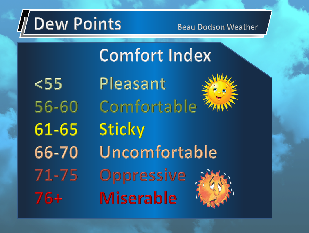
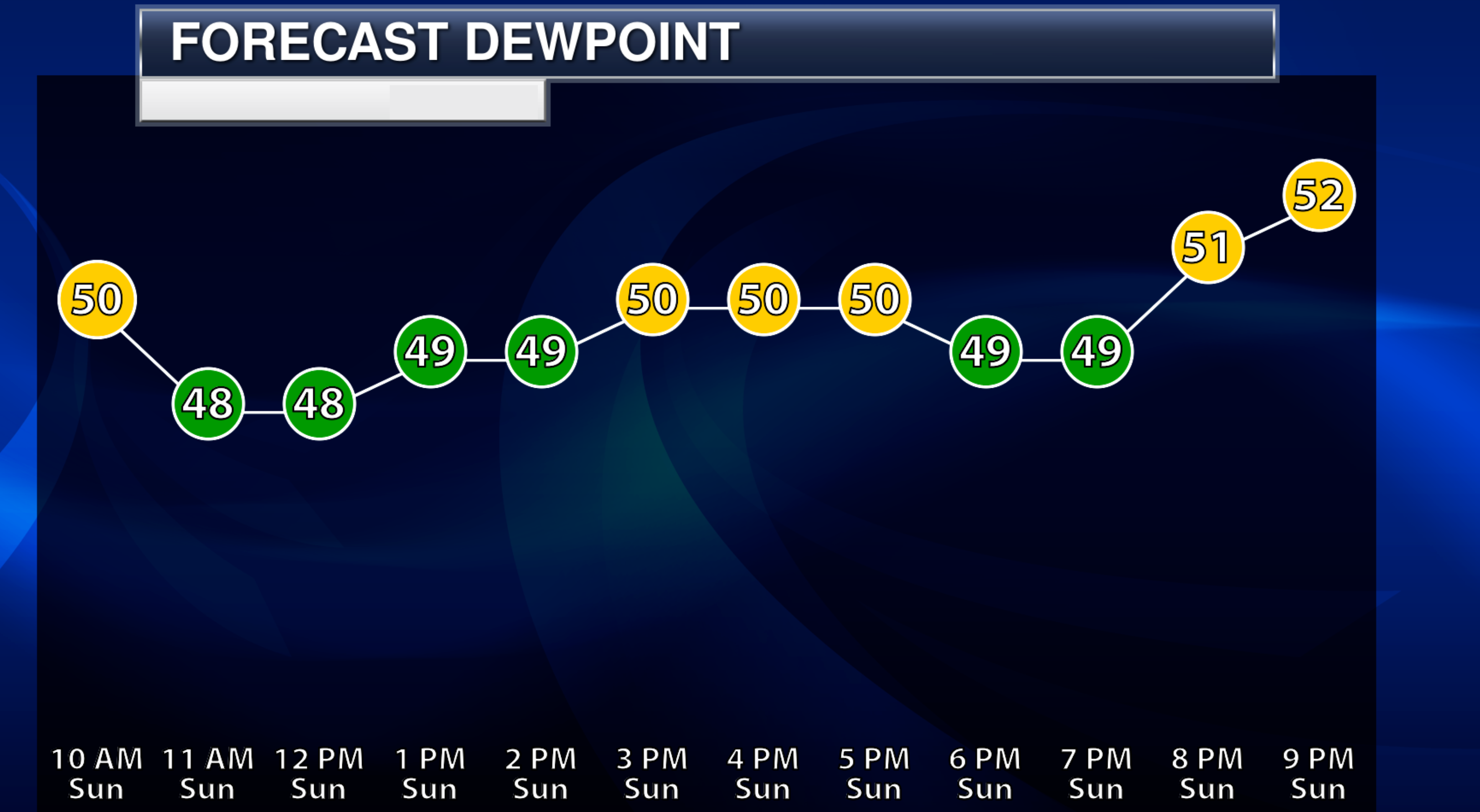
Dry conditions. Plenty of sunshine. Decent temperatures. Decent dew points.
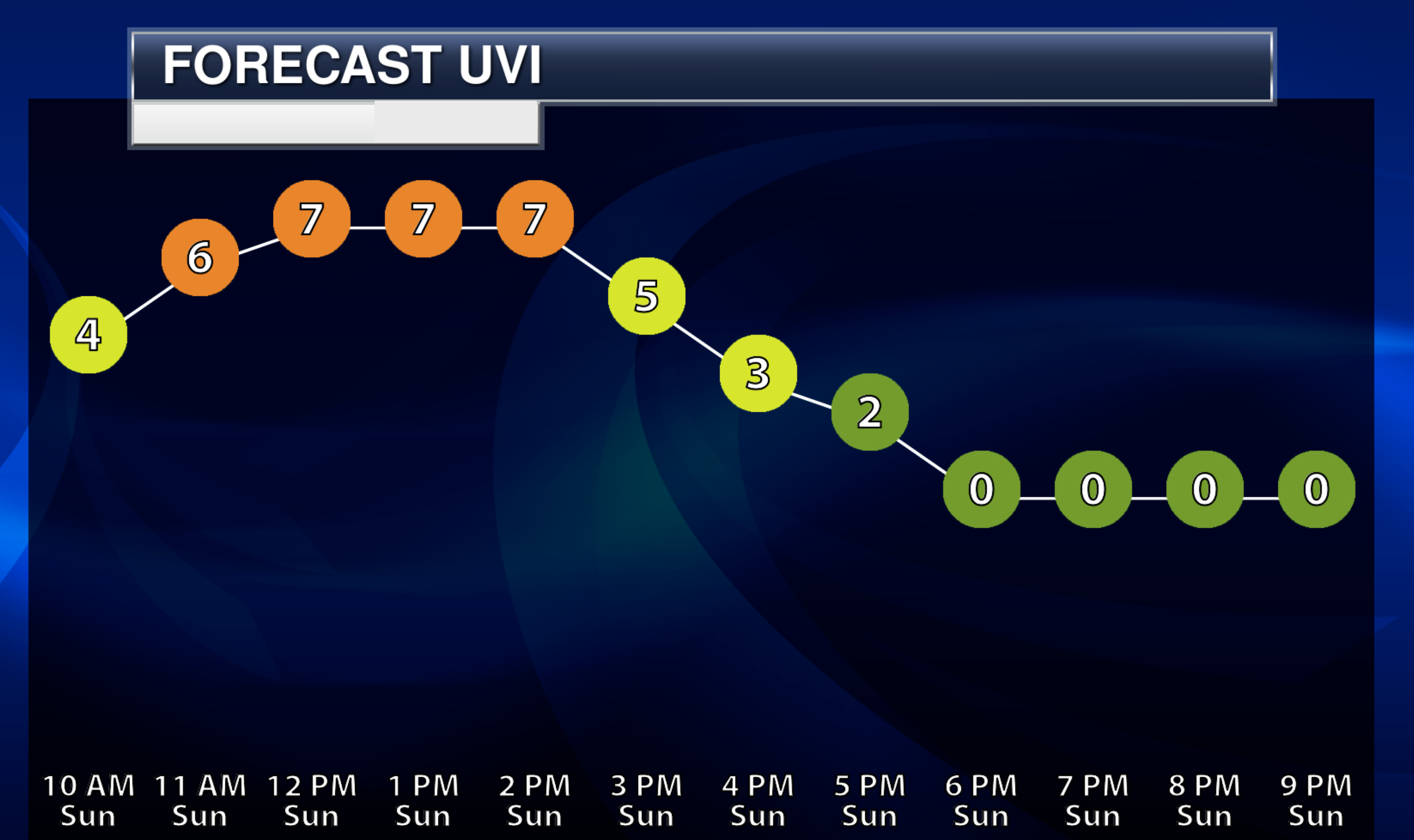
If you are hiking, camping, or boating, then you will not have any concerns other than sunburn. Sunscreen weather is upon us.
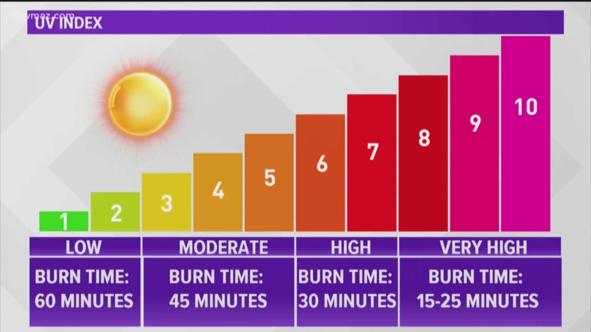
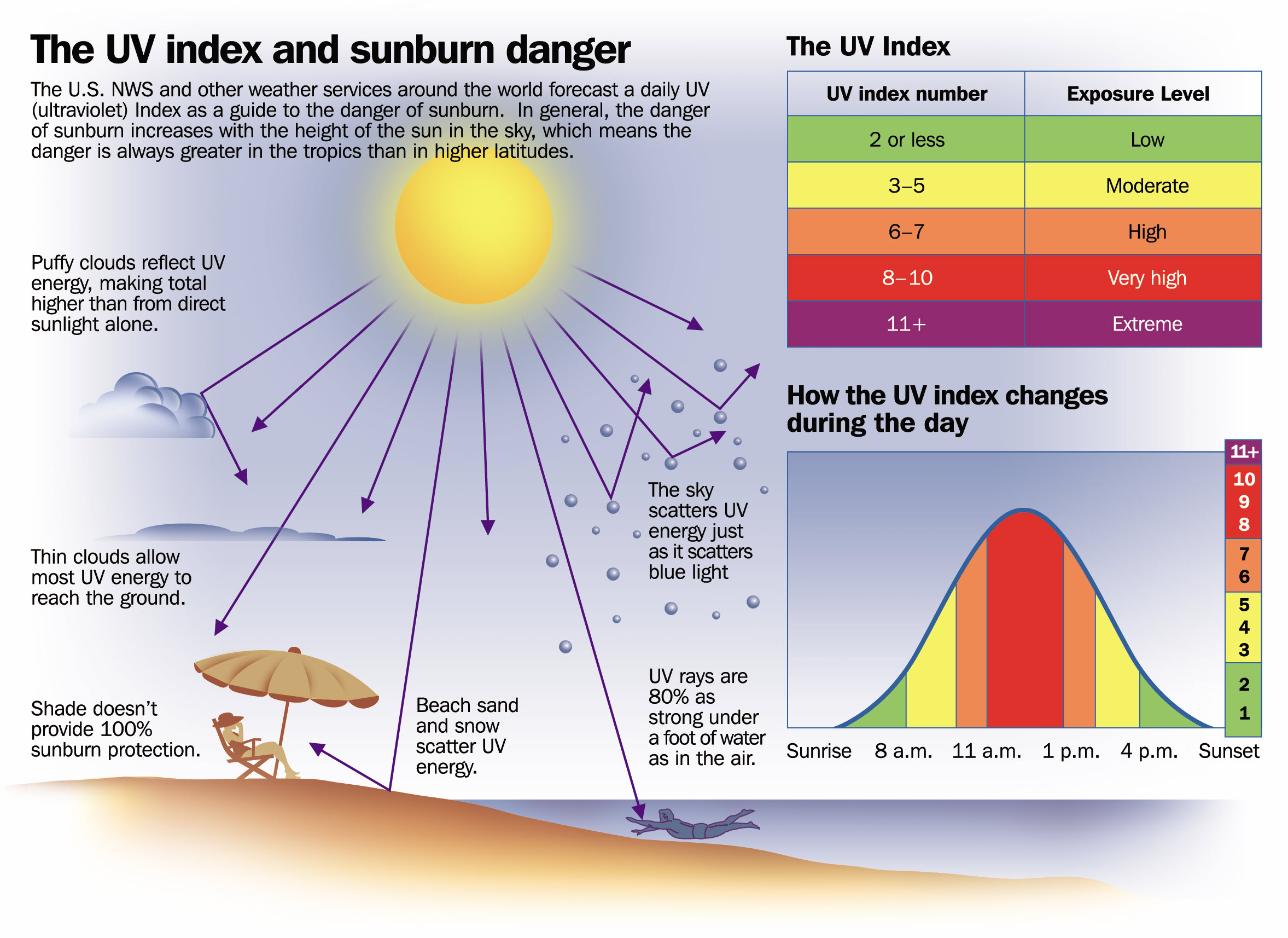
The UV index will peak each day in the 7 to 10 range. That is high to very high. Thus, protect your skin, as always.
We will experience a warming trend through the week. Each day will be a little bit warmer.
Temperatures will be a bit lower today and tomorrow over our eastern counties. That is where clouds may be a tad thicker and slightly cooler air will filter in.
Otherwise, expect partly to mostly sunny sky conditions today through Tuesday afternoon.
A few more clouds Wednesday and Thursday. A couple of showers and thunderstorms will be possible Wednesday afternoon into Thursday night.
A cold front will approach the region Friday and Saturday. This will slightly increase shower and thunderstorm chances. For now, I have chances in the 20 to 30% range.
If the front arrives a bit stronger, then I will need to bump those numbers up a bit more. Perhaps into the 40% to 60% range. For now, I left it on the lower end of the precipitation probability scale.
Temperatures will warm into the upper 80s and lower 90s this week.
It will be a bit cooler by Sunday. That would be behind the incoming cold front. That may end up being another back-door cold front. That means it pushes in from the northeast and will be moving southwest.
For now, enjoy the nice weather. I will keep looking for our much needed rain.
The summer video forecast can be found on your Beau Dodson Weather Talk app or on the www.weathertalk.com website under the video tab.
.
Click here if you would like to return to the top of the page.
This outlook covers southeast Missouri, southern Illinois, western Kentucky, and far northwest Tennessee.
Today through April 18th: A couple of the Saturday afternoon and night thunderstorms could produce damaging wind and hail. The tornado risk is low, but not zero. Mainly over Missouri for the tornado risk. The line will weaken with time as it moves farther east.
.
Today’s Storm Prediction Center’s Severe Weather Outlook
Light green is where thunderstorms may occur but should be below severe levels.
Dark green is a level one risk. Yellow is a level two risk. Orange is a level three (enhanced) risk. Red is a level four (moderate) risk. Pink is a level five (high) risk.
One is the lowest risk. Five is the highest risk.
A severe storm is one that produces 58 mph wind or higher, quarter size hail, and/or a tornado.
Explanation of tables. Click here.

.
Tornado Probability Outlook

.
Large Hail Probability Outlook

.
High wind Probability Outlook

.
Tomorrow’s severe weather outlook.

.
Day Three Severe Weather Outlook

.

.
The images below are from NOAA’s Weather Prediction Center.
24-hour precipitation outlook..
 .
.
.
48-hour precipitation outlook.
. .
.
![]()
_______________________________________
.

Click here if you would like to return to the top of the page.
Again, as a reminder, these are models. They are never 100% accurate. Take the general idea from them.
What should I take from these?
- The general idea and not specifics. Models usually do well with the generalities.
- The time-stamp is located in the upper left corner.
.
What am I looking at?
You are looking at computer model data. Meteorologists use many different models to forecast the weather.
Occasionally, these maps are in Zulu time. 12z=7 AM. 18z=1 PM. 00z=7 PM. 06z=1 AM
Green represents light rain. Dark green represents moderate rain. Yellow and orange represent heavier rain.
This animation is the SPC WRF Model.
.
This animation is the Hrrr Model.
Occasionally, these maps are in Zulu time. 12z=7 AM. 18z=1 PM. 00z=7 PM. 06z=1 AM
.
This animation is the NAM 3K Model.
Occasionally, these maps are in Zulu time. 12z=7 AM. 18z=1 PM. 00z=7 PM. 06z=1 AM
.
.
..![]()

.
Click here if you would like to return to the top of the page.
.Average high temperatures for this time of the year are around 81 degrees.
Average low temperatures for this time of the year are around 60 degrees.
Average precipitation during this time period ranges from 0.80″ to 1.00″
Six to Ten Day Outlook.
Blue is below average. Red is above average. The no color zone represents equal chances.
Average highs for this time of the year are in the lower 60s. Average lows for this time of the year are in the lower 40s.
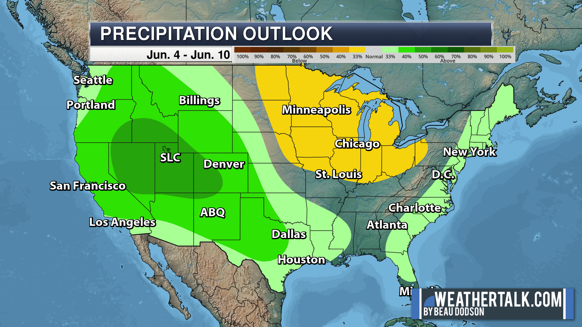
Green is above average precipitation. Yellow and brown favors below average precipitation. Average precipitation for this time of the year is around one inch per week.
.

Average low temperatures for this time of the year are around 62 degrees.
Average precipitation during this time period ranges from 0.80″ to 1.00″
.
.
![]()
The app is for subscribers. Subscribe at www.weathertalk.com/welcome then go to your app store and search for WeatherTalk
Subscribers, PLEASE USE THE APP. ATT and Verizon are not reliable during severe weather. They are delaying text messages.
The app is under WeatherTalk in the app store.
Apple users click here
Android users click here
.

Radars and Lightning Data
Interactive-city-view radars. Clickable watches and warnings.
https://wtalk.co/B3XHASFZ
If the radar is not updating then try another one. If a radar does not appear to be refreshing then hit Ctrl F5. You may also try restarting your browser.
Backup radar site in case the above one is not working.
https://weathertalk.com/morani
Regional Radar
https://imagery.weathertalk.com/prx/RadarLoop.mp4
** NEW ** Zoom radar with chaser tracking abilities!
ZoomRadar
Lightning Data (zoom in and out of your local area)
https://wtalk.co/WJ3SN5UZ
Not working? Email me at beaudodson@usawx.com
National map of weather watches and warnings. Click here.
Storm Prediction Center. Click here.
Weather Prediction Center. Click here.
.

Live lightning data: Click here.
Real time lightning data (another one) https://map.blitzortung.org/#5.02/37.95/-86.99
Our new Zoom radar with storm chases
.
.

Interactive GOES R satellite. Track clouds. Click here.
GOES 16 slider tool. Click here.
College of DuPage satellites. Click here
.

Here are the latest local river stage forecast numbers Click Here.
Here are the latest lake stage forecast numbers for Kentucky Lake and Lake Barkley Click Here.
.
.
Find Beau on Facebook! Click the banner.








 .
.