
Click one of the links below to take you directly to that section
Do you have any suggestions or comments? Email me at beaudodson@usawx.com
.
.
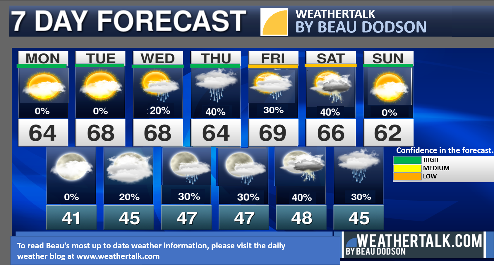
Seven-day forecast for southeast Missouri, southern Illinois, western Kentucky, and western Tennessee.
This is a BLEND for the region. Scroll down to see the region by region forecast.
THE FORECAST IS GOING TO VARY FROM LOCATION TO LOCATION. Scroll down to see the region by region forecast.
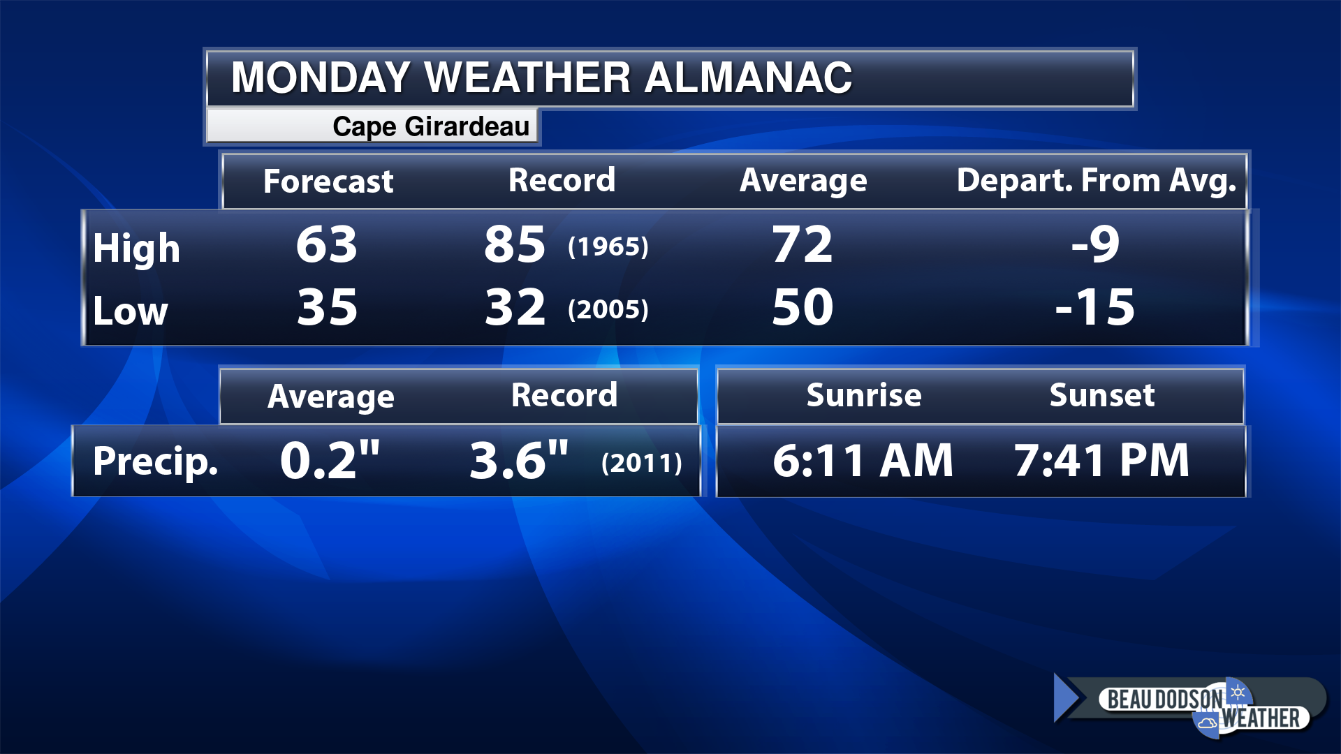
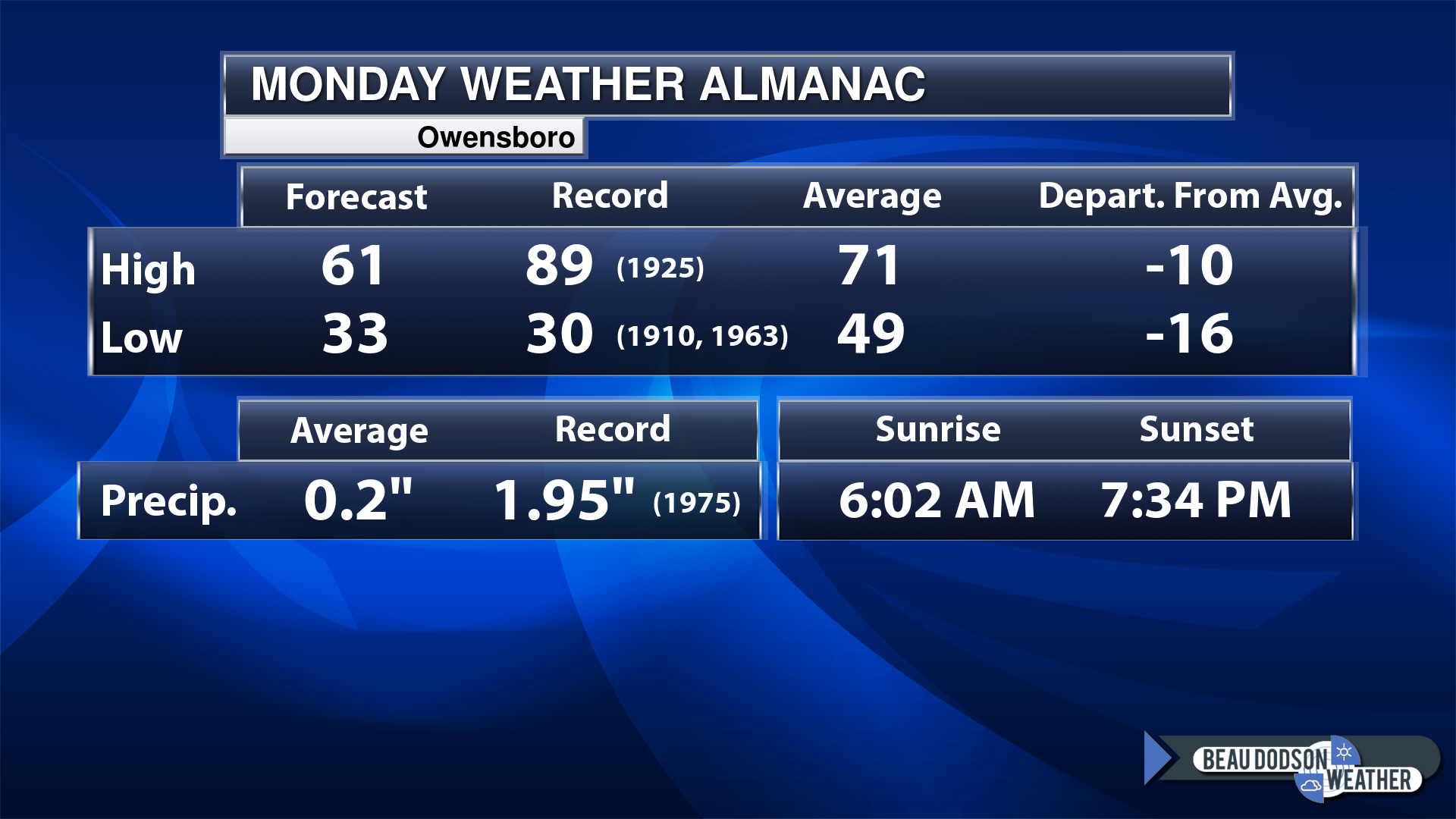
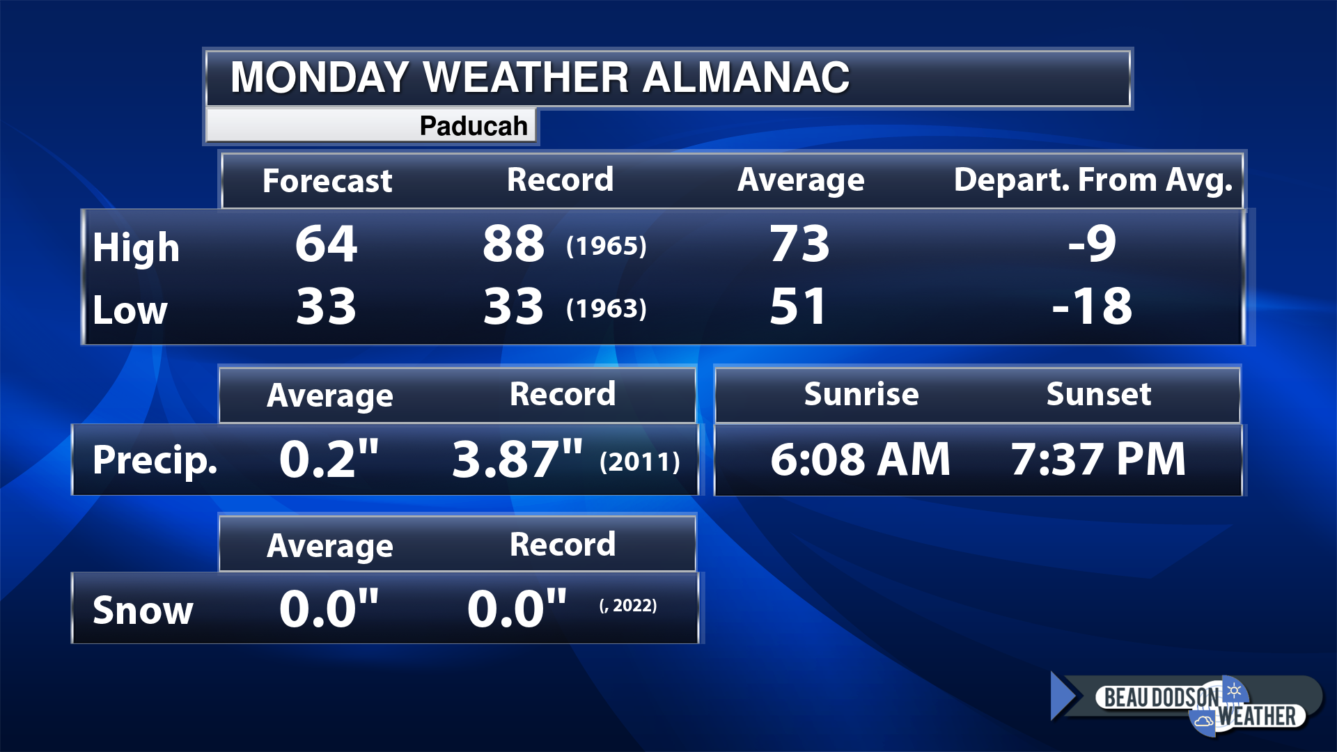
Today’s Local Almanacs (for a few select cities). Your location will be comparable.
Note, the low is this morning’s low and not tomorrows.
This shows you the forecast high. The records. The average and then the departure (how many degrees above or below average will temperatures be).
The graphic shows you what our average daily rainfall is for the day. That is not what is expected (that is the average from past years).
If you have not subscribed to my YouTube Channel then click on this link and it will take you to my videos.
Click the button below and it will take you to the Beau Dodson YouTube Channel.
48-hour forecast


.

.
Monday to Monday
1. Is lightning in the forecast? Possible. I am watching a cold front Friday night into Saturday. We will have on and off rain chances this week, but perhaps the best chance of lightning would be with that frontal boundary.
2. Are severe thunderstorms in the forecast? Not at this time.
3. Is flash flooding in the forecast? No.
4. Will the heat index exceed 100 degrees? No.
5. Will the wind chill dip below 10 degrees? No.
6. Is measurable snow and/or sleet in the forecast? No.
7. Is freezing rain/ice in the forecast? No.
Freezing rain is rain that falls and instantly freezes on objects such as trees and power lines
.
Monday, April 24, 2023
Confidence in the forecast? High Confidence
Monday Forecast: Mostly sunny.
What is the chance of precipitation?
Far northern southeast Missouri ~ 0%
Southeast Missouri ~ 0%
The Missouri Bootheel ~ 0%
I-64 Corridor of southern Illinois ~ 0%
Southern Illinois ~ 0%
Extreme southern Illinois (southern seven counties) ~ 0%
Far western Kentucky ~ 0%
The Pennyrile area of western KY ~ 0%
Northwest Kentucky (near Indiana border) ~ 0%
Northwest Tennessee ~ 0%
Coverage of precipitation:
Timing of the precipitation:
Temperature range:
Far northern southeast Missouri ~ 62° to 64°
Southeast Missouri ~ 62° to 64°
The Missouri Bootheel ~ 64° to 66°
I-64 Corridor of southern Illinois ~ 60° to 62°
Southern Illinois ~ 62° to 64°
Extreme southern Illinois (southern seven counties) ~ 62° to 64°
Far western Kentucky ~ 62° to 64°
The Pennyrile area of western KY ~ 62° to 64°
Northwest Kentucky (near Indiana border) ~ 62° to 64°
Northwest Tennessee ~ 62° to 65°
Winds will be from this direction: West 8 to 16 mph
Wind chill or heat index (feels like) temperature forecast: 60° to 65°
What impacts are anticipated from the weather?
Should I cancel my outdoor plans? No
UV Index: 8. Very high.
Sunrise: 6:09AM
Sunset: 7:38 PM
.
Monday night Forecast: Partly cloudy.
What is the chance of precipitation?
Far northern southeast Missouri ~ 0%
Southeast Missouri ~ 0%
The Missouri Bootheel ~ 0%
I-64 Corridor of southern Illinois ~ 0%
Southern Illinois ~ 0%
Extreme southern Illinois (southern seven counties) ~ 0%
Far western Kentucky ~ 0%
The Pennyrile area of western KY ~ 0%
Northwest Kentucky (near Indiana border) ~ 0%
Northwest Tennessee ~ 0%
Coverage of precipitation:
Timing of the precipitation:
Temperature range:
Far northern southeast Missouri ~38° to 42°
Southeast Missouri ~ 40° to 42°
The Missouri Bootheel ~ 42° to 44°
I-64 Corridor of southern Illinois ~ 38° to 40°
Southern Illinois ~ 40° to 42°
Extreme southern Illinois (southern seven counties) ~ 40° to 42°
Far western Kentucky ~ 43° to 44°
The Pennyrile area of western KY ~ 42° to 44°
Northwest Kentucky (near Indiana border) ~ 42° to 44°
Northwest Tennessee ~ 42° to 44°
Winds will be from this direction: Southeast 7 to 14 mph
Wind chill or heat index (feels like) temperature forecast: 40° to 45°
What impacts are anticipated from the weather?
Should I cancel my outdoor plans? No
Moonrise: 9:01 AM
Moonset:
The phase of the moon: Waning Crescent
.
Tuesday, April 25, 2023
Confidence in the forecast? High Confidence
Tuesday Forecast: A mix of sun and clouds.
What is the chance of precipitation?
Far northern southeast Missouri ~ 0%
Southeast Missouri ~ 0%
The Missouri Bootheel ~ 0%
I-64 Corridor of southern Illinois ~ 0%
Southern Illinois ~ 0%
Extreme southern Illinois (southern seven counties) ~ 0%
Far western Kentucky ~ 0%
The Pennyrile area of western KY ~ 0%
Northwest Kentucky (near Indiana border) ~ 0%
Northwest Tennessee ~ 0%
Coverage of precipitation:
Timing of the precipitation:
Temperature range:
Far northern southeast Missouri ~ 64° to 68°
Southeast Missouri ~ 64° to 68°
The Missouri Bootheel ~ 64° to 68°
I-64 Corridor of southern Illinois ~ 64° to 68°
Southern Illinois ~ 64° to 68°
Extreme southern Illinois (southern seven counties) ~ 64° to 68°
Far western Kentucky ~ 64° to 68°
The Pennyrile area of western KY ~ 64° to 68°
Northwest Kentucky (near Indiana border) ~ 64° to 68°
Northwest Tennessee ~ 64° to 68°
Winds will be from this direction: Southeast 8 to 16 mph.
Wind chill or heat index (feels like) temperature forecast: 64° to 68°
What impacts are anticipated from the weather?
Should I cancel my outdoor plans? No
UV Index: 8. Very high.
Sunrise: 6:08 AM
Sunset: 7:39 PM
.
Tuesday night Forecast: Partly cloudy. A slight chance of showers.
What is the chance of precipitation?
Far northern southeast Missouri ~ 10%
Southeast Missouri ~ 10%
The Missouri Bootheel ~ 30%
I-64 Corridor of southern Illinois ~ 10%
Southern Illinois ~ 20%
Extreme southern Illinois (southern seven counties) ~ 20%
Far western Kentucky ~ 20%
The Pennyrile area of western KY ~ 20%
Northwest Kentucky (near Indiana border) ~ 20%
Northwest Tennessee ~ 30%
Coverage of precipitation: Isolated
Timing of the precipitation: After 10 pm
Temperature range:
Far northern southeast Missouri ~ 42° to 45°
Southeast Missouri ~ 43° to 46°
The Missouri Bootheel ~ 44° to 48°
I-64 Corridor of southern Illinois ~ 42° to 45°
Southern Illinois ~ 43° to 46°
Extreme southern Illinois (southern seven counties) ~ 43° to 46°
Far western Kentucky ~ 43° to 46°
The Pennyrile area of western KY ~ 43° to 46°
Northwest Kentucky (near Indiana border) ~ 43° to 46°
Northwest Tennessee ~ 44° to 48°
Winds will be from this direction: East southeast 7 to 14 mph
Wind chill or heat index (feels like) temperature forecast: 42° to 45°
What impacts are anticipated from the weather? Wet roadways.
Should I cancel my outdoor plans? No
Moonrise: 9:52 AM
Moonset: 12:43 AM
The phase of the moon: Waxing Crescent
.
Wednesday, April 26, 2023
Confidence in the forecast? High Confidence
Wednesday Forecast: Partly sunny. A slight chance of showers.
What is the chance of precipitation?
Far northern southeast Missouri ~ 20%
Southeast Missouri ~ 20%
The Missouri Bootheel ~ 20%
I-64 Corridor of southern Illinois ~ 20%
Southern Illinois ~ 20%
Extreme southern Illinois (southern seven counties) ~ 20%
Far western Kentucky ~ 20%
The Pennyrile area of western KY ~ 20%
Northwest Kentucky (near Indiana border) ~ 20%
Northwest Tennessee ~ 20%
Coverage of precipitation: Widely scattered
Timing of the precipitation: Any given point of time
Temperature range:
Far northern southeast Missouri ~ 64° to 68°
Southeast Missouri ~ 64° to 68°
The Missouri Bootheel ~ 64° to 68°
I-64 Corridor of southern Illinois ~ 64° to 68°
Southern Illinois ~ 64° to 68°
Extreme southern Illinois (southern seven counties) ~ 64° to 68°
Far western Kentucky ~ 64° to 68°
The Pennyrile area of western KY ~ 64° to 68°
Northwest Kentucky (near Indiana border) ~ 64° to 68°
Northwest Tennessee ~ 64° to 68°
Winds will be from this direction: NE 8 to 16 mph
Wind chill or heat index (feels like) temperature forecast: 64° to 68°
What impacts are anticipated from the weather? Wet roadways.
Should I cancel my outdoor plans? No, but check the Beau Dodson Weather Radars
UV Index: 8. Very high.
Sunrise: 6:07 AM
Sunset: 7:40 PM
.
Wednesday night Forecast: Partly cloudy. A chance of showers.
What is the chance of precipitation?
Far northern southeast Missouri ~ 20%
Southeast Missouri ~ 30%
The Missouri Bootheel ~ 30%
I-64 Corridor of southern Illinois ~ 20%
Southern Illinois ~ 30%
Extreme southern Illinois (southern seven counties) ~ 30%
Far western Kentucky ~ 30%
The Pennyrile area of western KY ~ 30%
Northwest Kentucky (near Indiana border) ~ 30%
Northwest Tennessee ~ 30%
Coverage of precipitation: Scattered
Timing of the precipitation: Any given point of time
Temperature range:
Far northern southeast Missouri ~ 40° to 44°
Southeast Missouri ~ 43° to 46°
The Missouri Bootheel ~ 44° to 48°
I-64 Corridor of southern Illinois ~ 40° to 44°
Southern Illinois ~ 43° to 46°
Extreme southern Illinois (southern seven counties) ~ 44° to 48°
Far western Kentucky ~ 44° to 48°
The Pennyrile area of western KY ~ 44° to 48°
Northwest Kentucky (near Indiana border) ~ 44° to 48°
Northwest Tennessee ~ 44° to 48°
Winds will be from this direction: NE 8 to 16 mph
Wind chill or heat index (feels like) temperature forecast: 42° to 48°
What impacts are anticipated from the weather? Wet roadways.
Should I cancel my outdoor plans? No, but check the Beau Dodson Weather radars.
Moonrise: 10:50 AM
Moonset: 1:32 AM
The phase of the moon: Waxing Crescent
.
Thursday, April 27, 2023
Confidence in the forecast? High Confidence
Thursday Forecast: Intervals of clouds. A chance of showers.
What is the chance of precipitation?
Far northern southeast Missouri ~ 40%
Southeast Missouri ~ 40%
The Missouri Bootheel ~ 40%
I-64 Corridor of southern Illinois ~ 40%
Southern Illinois ~ 40%
Extreme southern Illinois (southern seven counties) ~ 40%
Far western Kentucky ~ 40%
The Pennyrile area of western KY ~ 40%
Northwest Kentucky (near Indiana border) ~ 40%
Northwest Tennessee ~ 40%
Coverage of precipitation: Scattered
Timing of the precipitation: Any given point of time
Temperature range:
Far northern southeast Missouri ~ 64° to 68°
Southeast Missouri ~ 64° to 68°
The Missouri Bootheel ~ 64° to 68°
I-64 Corridor of southern Illinois ~ 64° to 68°
Southern Illinois ~ 64° to 68°
Extreme southern Illinois (southern seven counties) ~ 64° to 68°
Far western Kentucky ~ 64° to 68°
The Pennyrile area of western KY ~ 64° to 68°
Northwest Kentucky (near Indiana border) ~ 64° to 68°
Northwest Tennessee ~ 64° to 68°
Winds will be from this direction: NE 8 to 16 mph
Wind chill or heat index (feels like) temperature forecast: 64° to 68°
What impacts are anticipated from the weather? Wet roadways.
Should I cancel my outdoor plans? No, but check the Beau Dodson Weather Radars
UV Index: 7. High.
Sunrise: 6:05AM
Sunset: 7:41 PM
.
Thursday night Forecast: Mostly cloudy. A chance of showers.
What is the chance of precipitation?
Far northern southeast Missouri ~ 40%
Southeast Missouri ~ 40%
The Missouri Bootheel ~ 40%
I-64 Corridor of southern Illinois ~ 40%
Southern Illinois ~ 40%
Extreme southern Illinois (southern seven counties) ~ 40%
Far western Kentucky ~ 40%
The Pennyrile area of western KY ~ 40%
Northwest Kentucky (near Indiana border) ~ 40%
Northwest Tennessee ~ 40%
Coverage of precipitation: Scattered
Timing of the precipitation: Any given point of time
Temperature range:
Far northern southeast Missouri ~ 44° to 48°
Southeast Missouri ~ 45° to 50°
The Missouri Bootheel ~ 46° to 50°
I-64 Corridor of southern Illinois ~ 44° to 48°
Southern Illinois ~ 44° to 48°
Extreme southern Illinois (southern seven counties) ~ 45° to 50°
Far western Kentucky ~ 45° to 50°
The Pennyrile area of western KY ~ 45° to 50°
Northwest Kentucky (near Indiana border) ~ 45° to 50°
Northwest Tennessee ~ 45° to 50°
Winds will be from this direction: NE 8 to 16 mph
Wind chill or heat index (feels like) temperature forecast: 42° to 48°
What impacts are anticipated from the weather? Wet roadways.
Should I cancel my outdoor plans? No, but check the Beau Dodson Weather radars.
Moonrise: 11:50 AM
Moonset: 2:14 AM
The phase of the moon: First Quarter
Click here if you would like to return to the top of the page.
-
- Cooler than average weather into the extended forecast.
- Monitoring on and off rain chances mid week into the weekend.
Weather advice:
As we prepare for spring, let’s make sure you have three to five ways of receiving your severe weather information.
.
Forecast Discussion
Brrr we are waking up to a cold morning across the region.
The Weather Observatory recorded a low of 27 degrees! Definitely a cold one.
There were widespread upper 20s to middle 30s over the entire region.
This morning will be the coldest morning of the forecast.
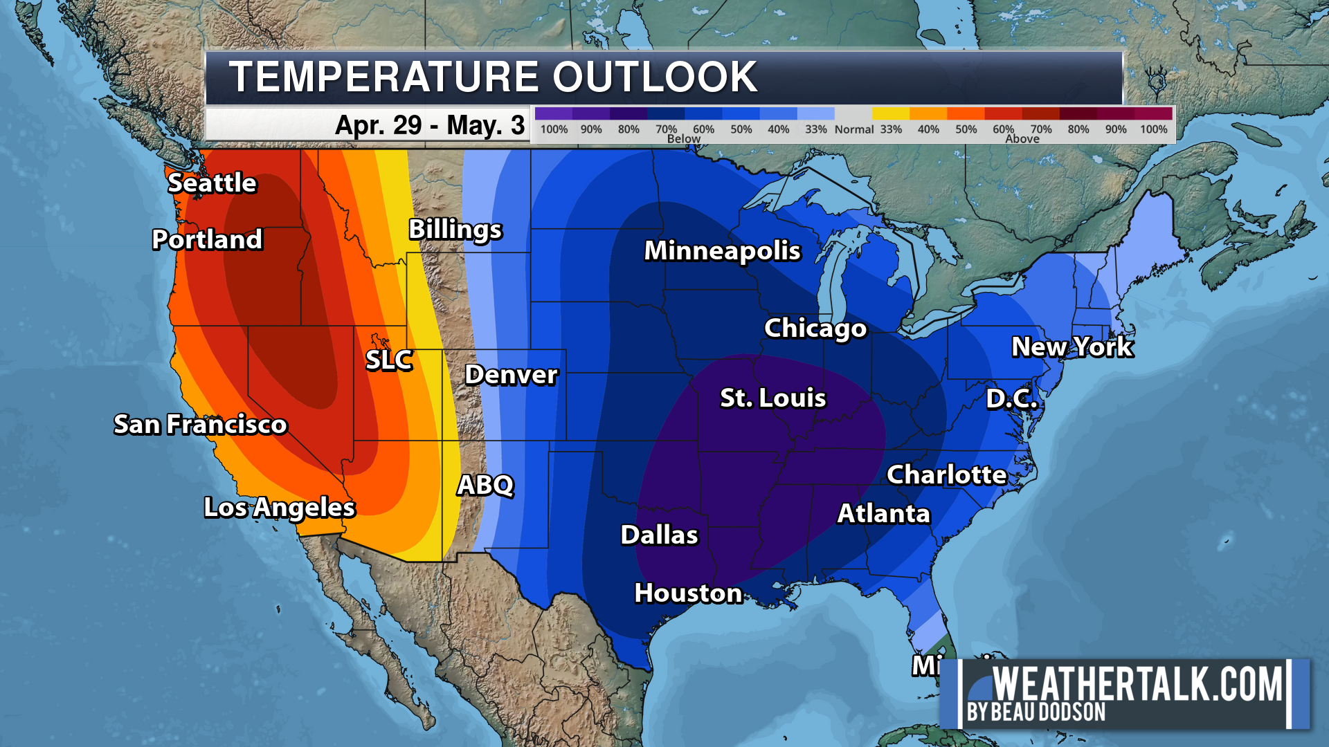
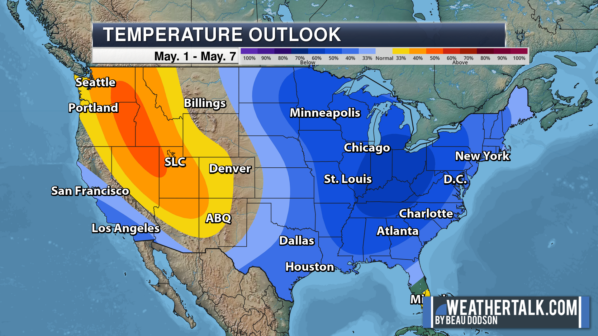
There are cooler than average temperatures in the 7 to 14 day forecast, but hopefully we can avoid another frost. It does become less and less likely that we experience another hard frost or freeze as we move into May. It has happened, but it just becomes a bit more unusual.
With that said, we will have to watch the cold shots in the week two forecast.
Today will deliver quite a bit of sunshine. Highs will be in the 60s. That is below the seasonal averages, which are around 70 to 72 degrees for high temperatures.
It will be chilly tonight with lows in the upper 30s to lower 40s.
Tuesday will be another dry day, but perhaps with some increase in clouds as we move through the day.
I can’t rule out some stray showers late Tuesday afternoon and Tuesday night. Mainly over the Missouri Bootheel and northwest Tennessee. Lower chances as you travel northward.
Expect thickening clouds Wednesday and Wednesday night as a frontal boundary slowly moves northward from the Gulf of Mexico.
This will spark a couple of showers across far southeast Missouri, the Bootheel, extreme southern Illinois, western Kentucky, and northwest Tennessee. These will be low-end chances. Widespread rain is unlikely.
The chances decrease as you travel northward.
The rain chances will try to inch northward late Wednesday night, but still remain in the low-end category. Scattered showers. Nothing heavy.
Scattered showers are likely Thursday into Thursday night as the slow moving system tracks across the region.
Rainfall totals Wednesday into Thursday night will likely be less than 0.50″.
A few showers and thunderstorms may develop Friday afternoon, but chances currently appear higher Friday night into Saturday evening. This is when a cold front will push through the region.
At this time, the threat of severe weather appears minimal, but as always check back for updates. It is spring!
Rain totals Friday into Saturday night will likely range from 0.40″ to 0.80″. That is the current forecast. There are some uncertainties about that systems rainfall totals. Guidance is not in agreement on the strength of the cold front and instability associated with it. Either way, it does not look to be a widespread heavy rain event.
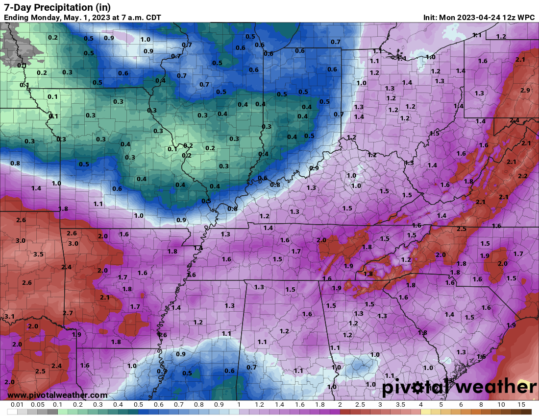
The entire week should produce rain totals from 0.2″ to 0.5″ over our northern counties and then 0.6″ to 1.20″ across our southern counties.
Here is the map showing that. Monitor for adjustments.
Double click the image to enlarge it.
Next week looks unsettled and cool, as well.
The cool weather is helping to slow down our severe weather threats.
April and May are our peak time of the year for tornadoes. Thus, any cooler than average weather can be a good thing. With each passing week, we are one step closer to summer.
.
Click here if you would like to return to the top of the page.
This outlook covers southeast Missouri, southern Illinois, western Kentucky, and far northwest Tennessee.
Today through April 18th: A couple of the Saturday afternoon and night thunderstorms could produce damaging wind and hail. The tornado risk is low, but not zero. Mainly over Missouri for the tornado risk. The line will weaken with time as it moves farther east.
.
Today’s Storm Prediction Center’s Severe Weather Outlook
Light green is where thunderstorms may occur but should be below severe levels.
Dark green is a level one risk. Yellow is a level two risk. Orange is a level three (enhanced) risk. Red is a level four (moderate) risk. Pink is a level five (high) risk.
One is the lowest risk. Five is the highest risk.
A severe storm is one that produces 58 mph wind or higher, quarter size hail, and/or a tornado.
Explanation of tables. Click here.

.
Tornado Probability Outlook

.
Large Hail Probability Outlook

.
High wind Probability Outlook

.
Tomorrow’s severe weather outlook.

.
Day Three Severe Weather Outlook

.

.
The images below are from NOAA’s Weather Prediction Center.
24-hour precipitation outlook..
 .
.
.
48-hour precipitation outlook.
. .
.
![]()
_______________________________________
.

Click here if you would like to return to the top of the page.
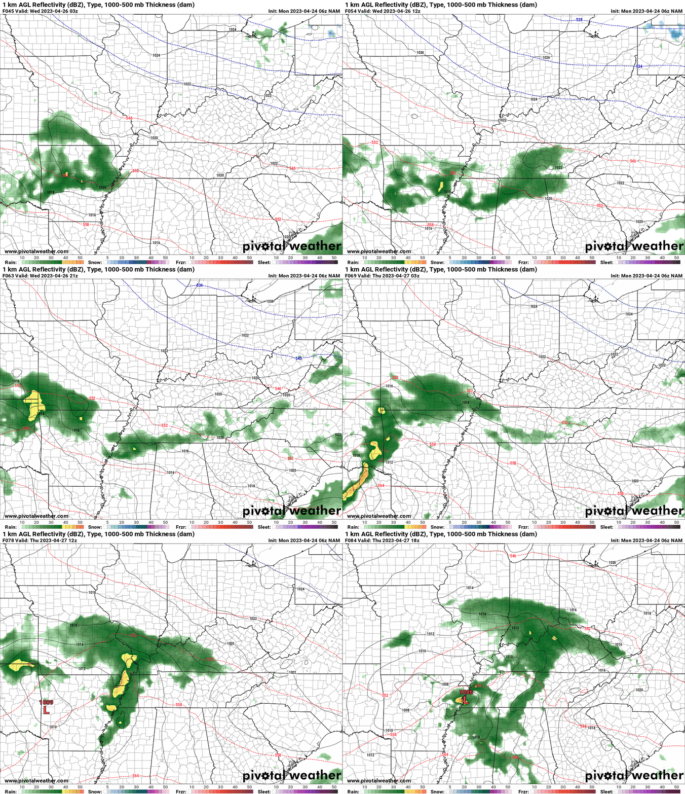
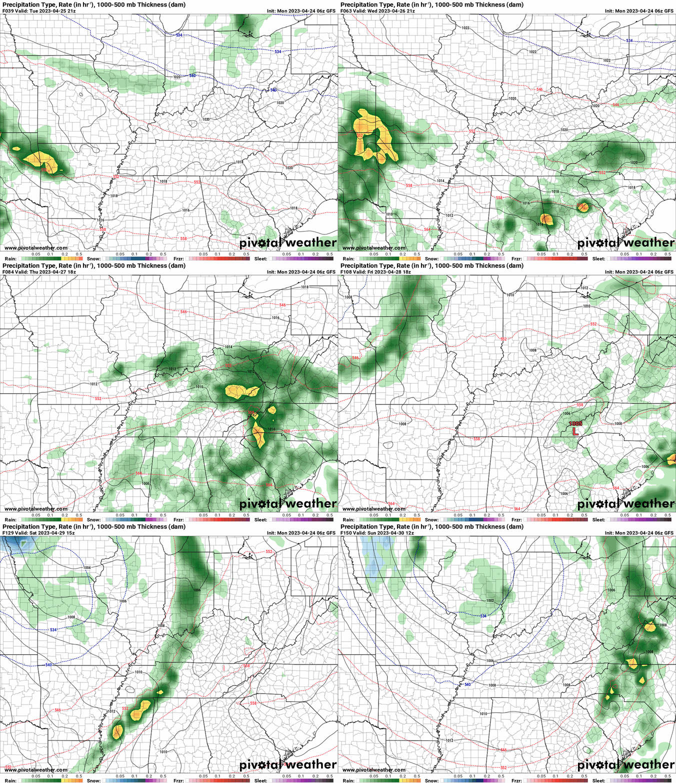
Again, as a reminder, these are models. They are never 100% accurate. Take the general idea from them.
What should I take from these?
- The general idea and not specifics. Models usually do well with the generalities.
- The time-stamp is located in the upper left corner.
.
What am I looking at?
You are looking at computer model data. Meteorologists use many different models to forecast the weather.
Occasionally, these maps are in Zulu time. 12z=7 AM. 18z=1 PM. 00z=7 PM. 06z=1 AM
Green represents light rain. Dark green represents moderate rain. Yellow and orange represent heavier rain.
This animation is the SPC WRF Model.
This animation is the NAM Model.
Occasionally, these maps are in Zulu time. 12z=7 AM. 18z=1 PM. 00z=7 PM. 06z=1 AM
.
This animation is the GFS Model.
Occasionally, these maps are in Zulu time. 12z=7 AM. 18z=1 PM. 00z=7 PM. 06z=1 AM
.
..![]()

.
Click here if you would like to return to the top of the page.
.Average high temperatures for this time of the year are around 72 degrees.
Average low temperatures for this time of the year are around 51 degrees.
Average precipitation during this time period ranges from 0.80″ to 1.00″
Six to Ten Day Outlook.
Blue is below average. Red is above average. The no color zone represents equal chances.
Average highs for this time of the year are in the lower 60s. Average lows for this time of the year are in the lower 40s.
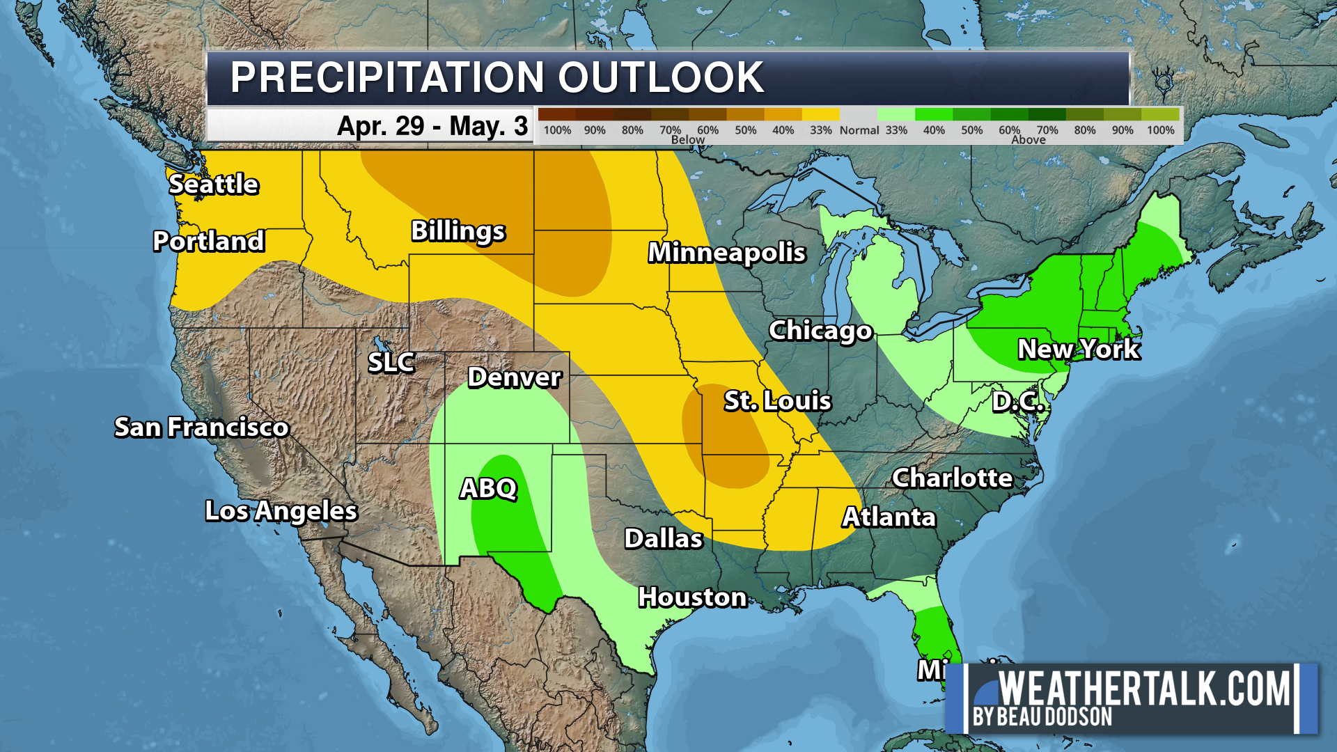
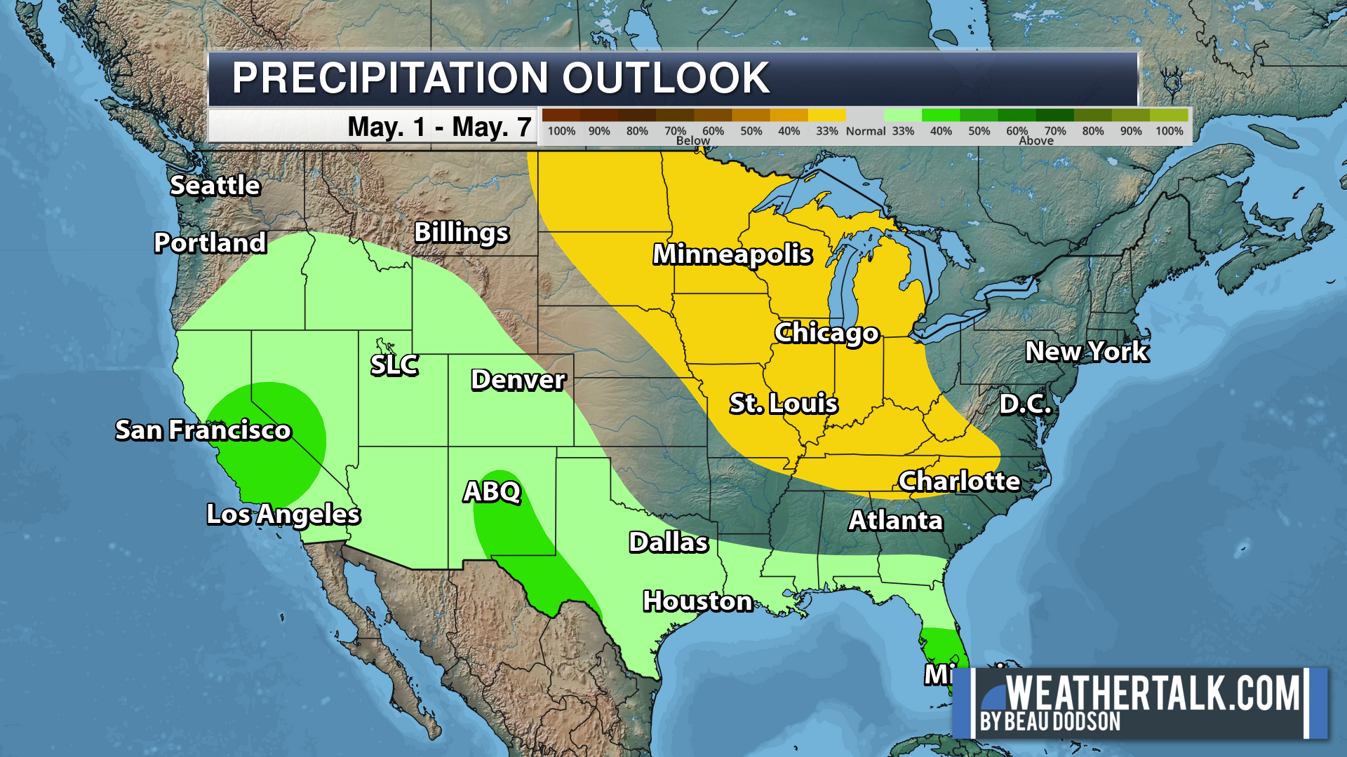
Green is above average precipitation. Yellow and brown favors below average precipitation. Average precipitation for this time of the year is around one inch per week.
.

Average low temperatures for this time of the year are around 52 degrees.
Average precipitation during this time period ranges from 0.80″ to 1.00″
.
.
![]()
The app is for subscribers. Subscribe at www.weathertalk.com/welcome then go to your app store and search for WeatherTalk
Subscribers, PLEASE USE THE APP. ATT and Verizon are not reliable during severe weather. They are delaying text messages.
The app is under WeatherTalk in the app store.
Apple users click here
Android users click here
.

Radars and Lightning Data
Interactive-city-view radars. Clickable watches and warnings.
https://wtalk.co/B3XHASFZ
If the radar is not updating then try another one. If a radar does not appear to be refreshing then hit Ctrl F5. You may also try restarting your browser.
Backup radar site in case the above one is not working.
https://weathertalk.com/morani
Regional Radar
https://imagery.weathertalk.com/prx/RadarLoop.mp4
** NEW ** Zoom radar with chaser tracking abilities!
ZoomRadar
Lightning Data (zoom in and out of your local area)
https://wtalk.co/WJ3SN5UZ
Not working? Email me at beaudodson@usawx.com
National map of weather watches and warnings. Click here.
Storm Prediction Center. Click here.
Weather Prediction Center. Click here.
.

Live lightning data: Click here.
Real time lightning data (another one) https://map.blitzortung.org/#5.02/37.95/-86.99
Our new Zoom radar with storm chases
.
.

Interactive GOES R satellite. Track clouds. Click here.
GOES 16 slider tool. Click here.
College of DuPage satellites. Click here
.

Here are the latest local river stage forecast numbers Click Here.
Here are the latest lake stage forecast numbers for Kentucky Lake and Lake Barkley Click Here.
.
.
Find Beau on Facebook! Click the banner.







 .
.