
Click one of the links below to take you directly to that section
Do you have any suggestions or comments? Email me at beaudodson@usawx.com
.
.
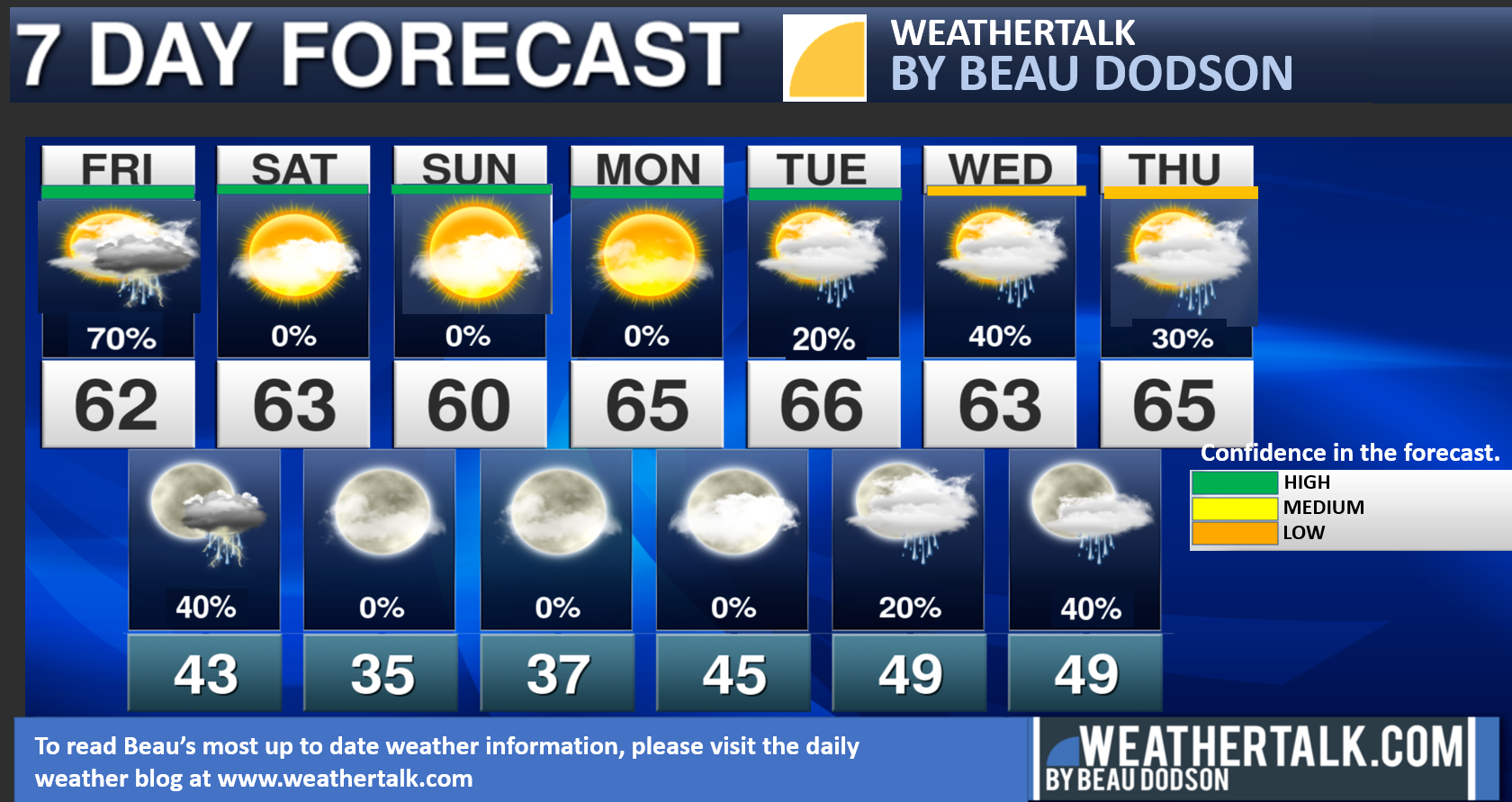
Seven-day forecast for southeast Missouri, southern Illinois, western Kentucky, and western Tennessee.
This is a BLEND for the region. Scroll down to see the region by region forecast.
THE FORECAST IS GOING TO VARY FROM LOCATION TO LOCATION. Scroll down to see the region by region forecast.
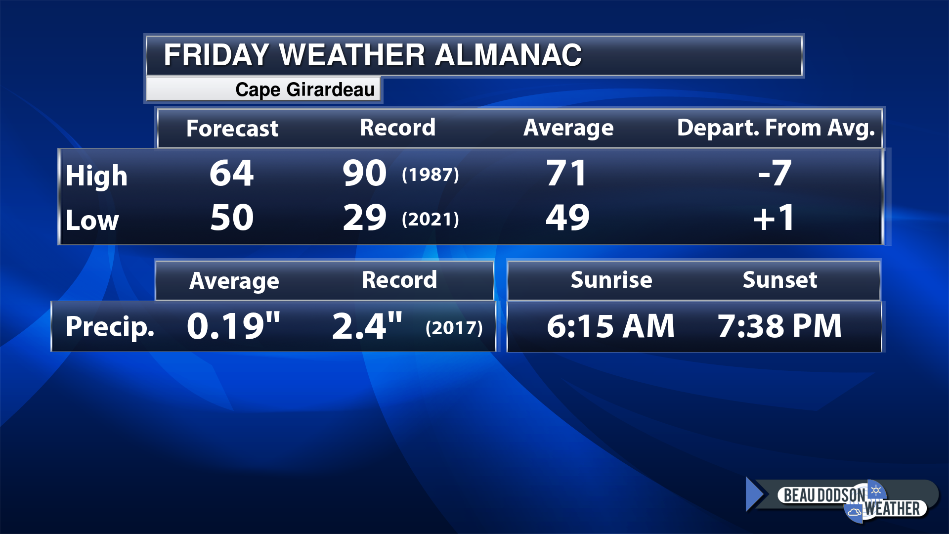
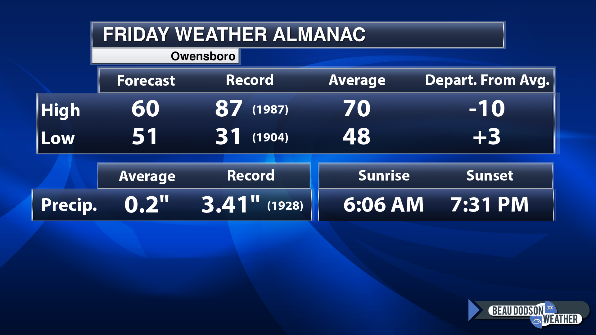
Today’s Local Almanacs (for a few select cities). Your location will be comparable.
Note, the low is this morning’s low and not tomorrows.
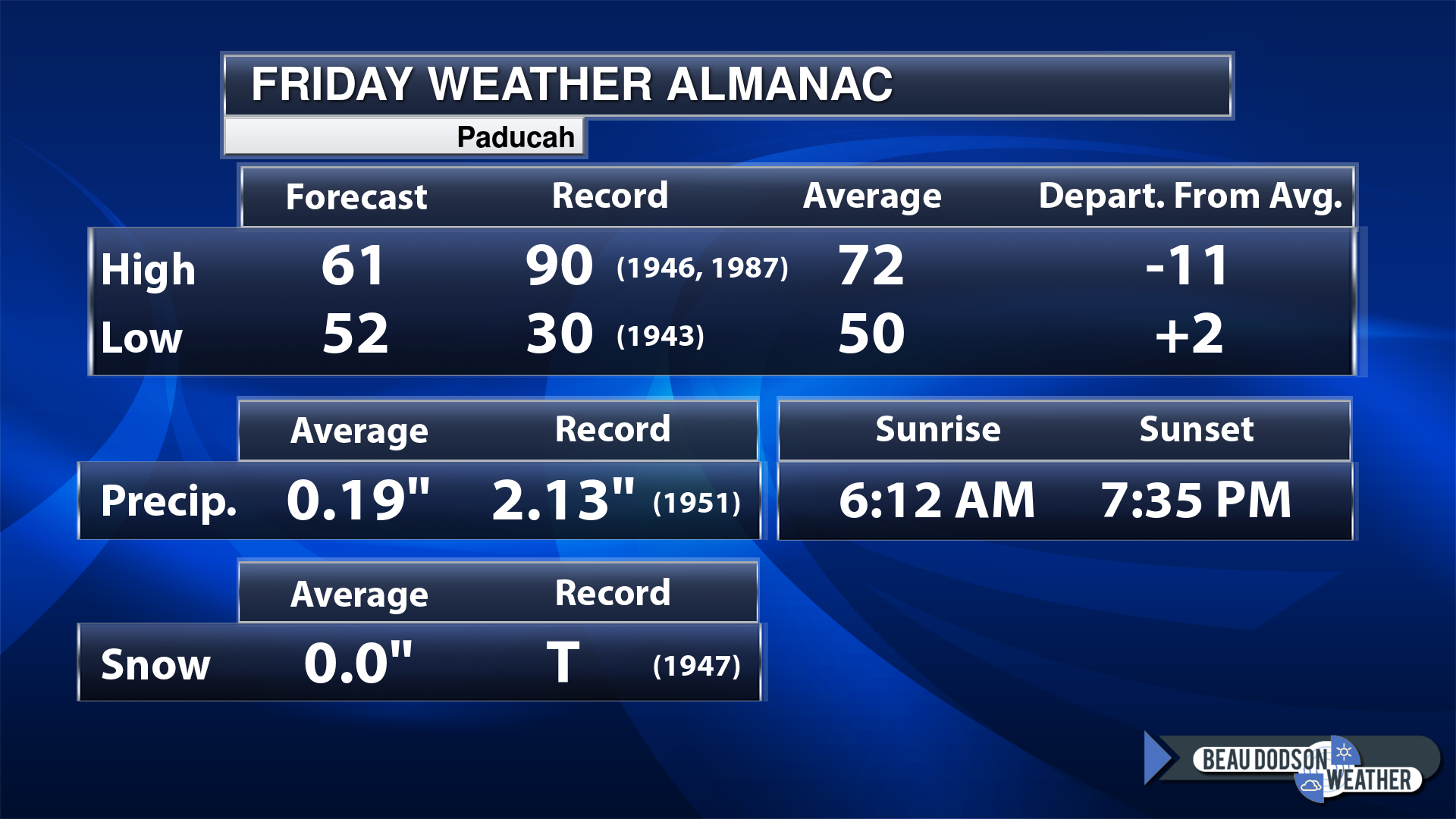
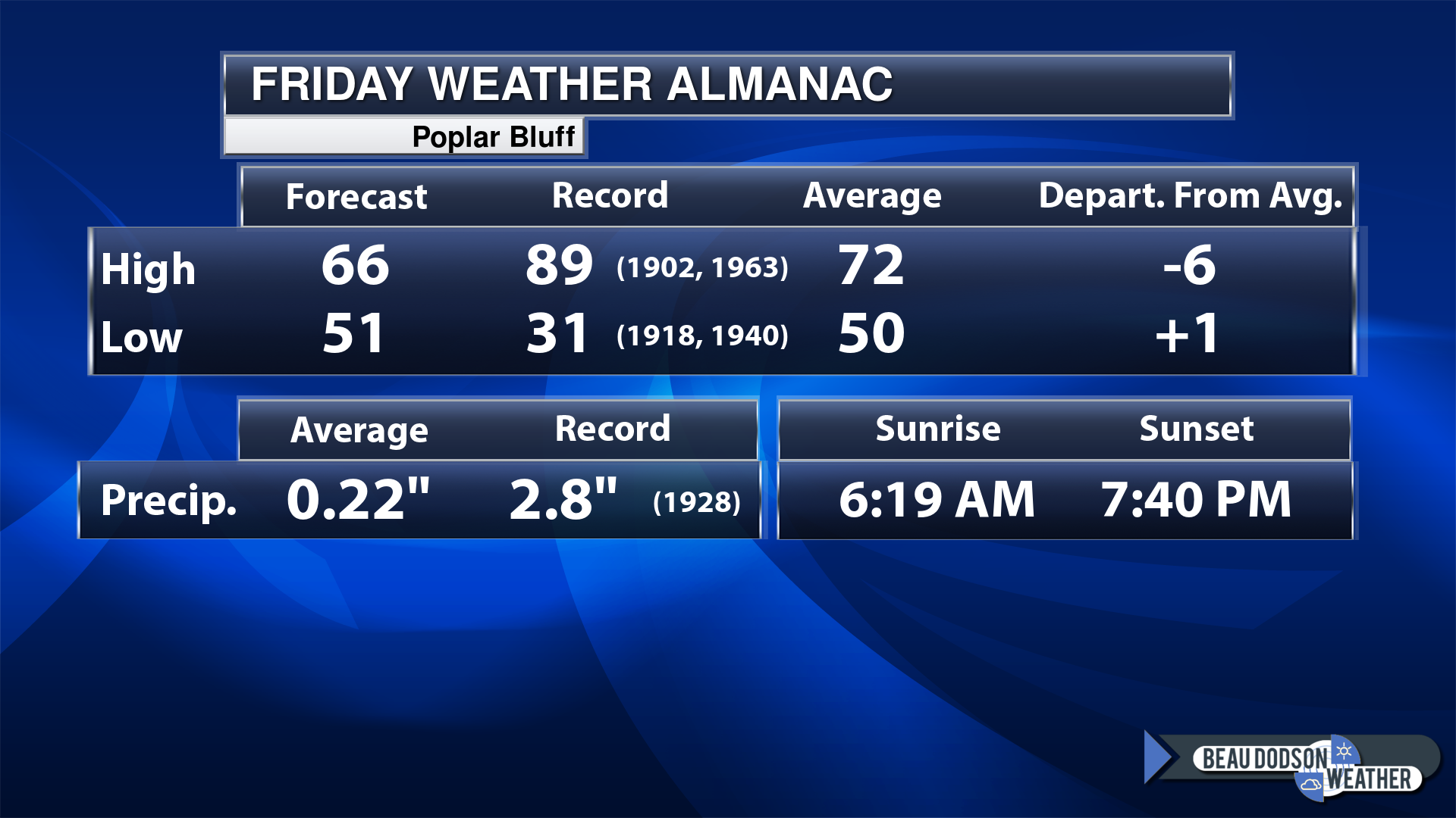
Today’s almanac numbers from a few select local cities.
The forecast temperature shows you today’s expected high and this morning’s low.
The graphic shows you the record high and record low for today. It shows you what year that occurred, as well.
It then shows you what today’s average temperature is.
Then, it shows you the departures (how many degrees above or below average temperatures will be).
It shows you the average precipitation for today. Average comes from thirty years of rain totals.
It also shows you the record rainfall for the date and what year that occurred.
The sunrise and sunset is also shown.
If you have not subscribed to my YouTube Channel then click on this link and it will take you to my videos.
Click the button below and it will take you to the Beau Dodson YouTube Channel.
48-hour forecast


.

.
Friday to Friday
1. Is lightning in the forecast? Yes. Lightning is possible today into this evening. I will monitor next Tuesday through Thursday.
2. Are severe thunderstorms in the forecast? No.
3. Is flash flooding in the forecast? Unlikely. Locally heavy rain will be possible today. The risk of flooding is low/isolated.
4. Will the heat index exceed 100 degrees? No.
5. Will the wind chill dip below 10 degrees? No.
6. Is measurable snow and/or sleet in the forecast? No.
7. Is freezing rain/ice in the forecast? No.
Freezing rain is rain that falls and instantly freezes on objects such as trees and power lines
.
Friday, April 21, 2023
Confidence in the forecast? High Confidence
Friday Forecast: Mostly cloudy. A chance of showers and thunderstorms. The chances will be higher over the eastern half of the region. Chances will be lower over southeast Missouri and southwest Illinois. Higher over southeast Illinois into Kentucky and Tennessee. Portions of the region may be mostly dry after the early morning hours as the band of rain shifts eastward. Keep that in mind. A second wave of rain will develop during the afternoon and evening and move in from the south southwest. Overspreading at least western Kentucky and Tennessee. We will have to see if Missouri and Illinois receive the afternoon rain (will depend on frontal boundary stalling).
What is the chance of precipitation?
Far northern southeast Missouri ~ 30%
Southeast Missouri ~ 40%
The Missouri Bootheel ~ 40%
I-64 Corridor of southern Illinois ~ 40%
Southern Illinois ~ 60%
Extreme southern Illinois (southern seven counties) ~ 70%
Far western Kentucky ~ 70%
The Pennyrile area of western KY ~ 90%
Northwest Kentucky (near Indiana border) ~ 80%
Northwest Tennessee ~ 70%
Coverage of precipitation: Numerous
Timing of the precipitation: Any given point of time
Temperature range:
Far northern southeast Missouri ~ 65° to 70°
Southeast Missouri ~ 65° to 70°
The Missouri Bootheel ~ 65° to 70°
I-64 Corridor of southern Illinois ~ 65° to 70°
Southern Illinois ~ 65° to 70°
Extreme southern Illinois (southern seven counties) ~ 65° to 70°
Far western Kentucky ~ 65° to 70°
The Pennyrile area of western KY ~ 65° to 70°
Northwest Kentucky (near Indiana border) ~ 65° to 70°
Northwest Tennessee ~ 65° to 70°
Winds will be from this direction: North 10 to 20 mph
Wind chill or heat index (feels like) temperature forecast: 62° to 68°
What impacts are anticipated from the weather? Wet roadways. Lightning. Locally heavy rain.
Should I cancel my outdoor plans? Have a plan B. Check the Beau Dodson Weather Radars.
UV Index: 5. Moderate.
Sunrise: 6:14 AM
Sunset: 7:36 PM
.
Friday night Forecast: Mostly cloudy. A chance of showers. A thunderstorm possible the first half of the night. Decreasing rain coverage with time. Rain chances will be highest over Kentucky and Tennessee with decreasing chances farther west.
What is the chance of precipitation?
Far northern southeast Missouri ~ 20%
Southeast Missouri ~ 20%
The Missouri Bootheel ~ 20%
I-64 Corridor of southern Illinois ~ 20%
Southern Illinois ~ 40%
Extreme southern Illinois (southern seven counties) ~ 60%
Far western Kentucky ~ 70%
The Pennyrile area of western KY ~ 90%
Northwest Kentucky (near Indiana border) ~ 70%
Northwest Tennessee ~ 70%
Coverage of precipitation: Numerous (mainly the eastern portion of the region).
Timing of the precipitation: Highest coverage before 12 AM.
Temperature range:
Far northern southeast Missouri ~ 40° to 42°
Southeast Missouri ~ 42° to 45°
The Missouri Bootheel ~ 43° to 46°
I-64 Corridor of southern Illinois ~ 40° to 42°
Southern Illinois ~ 42° to 45°
Extreme southern Illinois (southern seven counties) ~ 42° to 45°
Far western Kentucky ~ 43° to 46°
The Pennyrile area of western KY ~ 43° to 46°
Northwest Kentucky (near Indiana border) ~ 43° to 46°
Northwest Tennessee ~ 43° to 46°
Winds will be from this direction: North northwest 15 to 25 mph.
Wind chill or heat index (feels like) temperature forecast: 38° to 42°
What impacts are anticipated from the weather? Wet roadways. Lightning.
Should I cancel my outdoor plans? Have a plan B. Check the Beau Dodson Weather Radars.
Moonrise: 7:00 AM
Moonset: 9:35 PM
The phase of the moon: Waxing Crescent
.
Saturday, April 22, 2023
Confidence in the forecast? High Confidence
Saturday Forecast: Partly cloudy. More clouds over southern Illinois and northwest Kentucky vs the rest of the region. Cooler. Breezy, at times.
What is the chance of precipitation?
Far northern southeast Missouri ~ 0%
Southeast Missouri ~ 0%
The Missouri Bootheel ~ 0%
I-64 Corridor of southern Illinois ~ 0%
Southern Illinois ~ 0%
Extreme southern Illinois (southern seven counties) ~ 0%
Far western Kentucky ~ 0%
The Pennyrile area of western KY ~ 0%
Northwest Kentucky (near Indiana border) ~ 0%
Northwest Tennessee ~ 0%
Coverage of precipitation:
Timing of the precipitation:
Temperature range:
Far northern southeast Missouri ~ 54° to 56°
Southeast Missouri ~ 54° to 56°
The Missouri Bootheel ~ 56° to 60°
I-64 Corridor of southern Illinois ~ 53° to 56°
Southern Illinois ~ 55° to 58°
Extreme southern Illinois (southern seven counties) ~ 55° to 60°
Far western Kentucky ~ 55° to 60°
The Pennyrile area of western KY ~ 55° to 60°
Northwest Kentucky (near Indiana border) ~ 55° to 60°
Northwest Tennessee ~ 60° to 64°
Winds will be from this direction: West 10 to 20 mph. Gusty.
Wind chill or heat index (feels like) temperature forecast: 50° to 55°
What impacts are anticipated from the weather? Isolated wet roadways.
Should I cancel my outdoor plans? No. Check the Beau Dodson Weather Radars.
UV Index: 5. Moderate.
Sunrise: 6:12 AM
Sunset: 7:36 PM
.
Saturday night Forecast: Partly cloudy. Colder. A slight chance of patchy frost.
What is the chance of precipitation?
Far northern southeast Missouri ~ 0%
Southeast Missouri ~ 0%
The Missouri Bootheel ~ 0%
I-64 Corridor of southern Illinois ~ 0%
Southern Illinois ~ 0%
Extreme southern Illinois (southern seven counties) ~ 0%
Far western Kentucky ~ 0%
The Pennyrile area of western KY ~ 0%
Northwest Kentucky (near Indiana border) ~ 0%
Northwest Tennessee ~ 0%
Coverage of precipitation:
Timing of the precipitation:
Temperature range:
Far northern southeast Missouri ~ 32° to 35°
Southeast Missouri ~ 33° to 36°
The Missouri Bootheel ~ 34° to 38°
I-64 Corridor of southern Illinois ~ 32° to 35°
Southern Illinois ~ 34° to 38°
Extreme southern Illinois (southern seven counties) ~ 34° to 38°
Far western Kentucky ~ 36° to 38°
The Pennyrile area of western KY ~ 36° to 38°
Northwest Kentucky (near Indiana border) ~ 36° to 38°
Northwest Tennessee ~ 36° to 38°
Winds will be from this direction: West northwest 7 to 14 mph
Wind chill or heat index (feels like) temperature forecast: 30° to 36°
What impacts are anticipated from the weather? Patchy frost if winds subside.
Should I cancel my outdoor plans?
Moonrise: 7:34 AM
Moonset: 10:43 PM
The phase of the moon: Waxing Crescent
.
Sunday, April 23, 2023
Confidence in the forecast? High Confidence
Sunday Forecast: Mostly sunny.
What is the chance of precipitation?
Far northern southeast Missouri ~ 0%
Southeast Missouri ~ 0%
The Missouri Bootheel ~ 0%
I-64 Corridor of southern Illinois ~ 0%
Southern Illinois ~ 0%
Extreme southern Illinois (southern seven counties) ~ 0%
Far western Kentucky ~ 0%
The Pennyrile area of western KY ~ 0%
Northwest Kentucky (near Indiana border) ~ 0%
Northwest Tennessee ~ 0%
Coverage of precipitation:
Timing of the precipitation:
Temperature range:
Far northern southeast Missouri ~ 54° to 56°
Southeast Missouri ~ 54° to 56°
The Missouri Bootheel ~ 55° to 60°
I-64 Corridor of southern Illinois ~ 53° to 55°
Southern Illinois ~ 55° to 58°
Extreme southern Illinois (southern seven counties) ~ 55° to 60°
Far western Kentucky ~ 55° to 60°
The Pennyrile area of western KY ~ 55° to 60°
Northwest Kentucky (near Indiana border) ~ 55° to 60°
Northwest Tennessee ~ 58° to 60°
Winds will be from this direction: NW 7 to 14 mph.
Wind chill or heat index (feels like) temperature forecast: 52° to 60°
What impacts are anticipated from the weather?
Should I cancel my outdoor plans? No.
UV Index: 5. Moderate.
Sunrise: 6:10 AM
Sunset: 7:37 PM
.
Sunday night Forecast: Mostly clear. Cold. Patchy frost.
What is the chance of precipitation?
Far northern southeast Missouri ~ 0%
Southeast Missouri ~ 0%
The Missouri Bootheel ~ 0%
I-64 Corridor of southern Illinois ~ 0%
Southern Illinois ~ 0%
Extreme southern Illinois (southern seven counties) ~ 0%
Far western Kentucky ~ 0%
The Pennyrile area of western KY ~ 0%
Northwest Kentucky (near Indiana border) ~ 0%
Northwest Tennessee ~ 0%
Coverage of precipitation:
Timing of the precipitation:
Temperature range:
Far northern southeast Missouri ~ 33° to 36°
Southeast Missouri ~ 34° to 38°
The Missouri Bootheel ~ 34° to 38°
I-64 Corridor of southern Illinois ~ 33° to 36°
Southern Illinois ~ 34° to 38°
Extreme southern Illinois (southern seven counties) ~ 34° to 38°
Far western Kentucky ~ 36° to 38°
The Pennyrile area of western KY ~ 36° to 38°
Northwest Kentucky (near Indiana border) ~ 36° to 38°
Northwest Tennessee ~ 36° to 40°
Winds will be from this direction: North northwest 6 to 12 mph
Wind chill or heat index (feels like) temperature forecast: 33° to 38°
What impacts are anticipated from the weather? Patchy frost.
Should I cancel my outdoor plans? No.
Moonrise: 8:15 AM
Moonset: 11:46 PM
The phase of the moon: Waxing Crescent
.
Monday, April 24, 2023
Confidence in the forecast? High Confidence
Monday Forecast: Partly sunny.
What is the chance of precipitation?
Far northern southeast Missouri ~ 0%
Southeast Missouri ~ 0%
The Missouri Bootheel ~ 0%
I-64 Corridor of southern Illinois ~ 0%
Southern Illinois ~ 0%
Extreme southern Illinois (southern seven counties) ~ 0%
Far western Kentucky ~ 0%
The Pennyrile area of western KY ~ 0%
Northwest Kentucky (near Indiana border) ~ 0%
Northwest Tennessee ~ 0%
Coverage of precipitation:
Timing of the precipitation:
Temperature range:
Far northern southeast Missouri ~ 60° to 62°
Southeast Missouri ~ 60° to 64°
The Missouri Bootheel ~ 62° to 65°
I-64 Corridor of southern Illinois ~ 60° to 62°
Southern Illinois ~ 62° to 64°
Extreme southern Illinois (southern seven counties) ~ 62° to 64°
Far western Kentucky ~ 62° to 65°
The Pennyrile area of western KY ~ 62° to 65°
Northwest Kentucky (near Indiana border) ~ 60° to 64°
Northwest Tennessee ~ 63° to 66°
Winds will be from this direction: E NE 7 to 14 mph.
Wind chill or heat index (feels like) temperature forecast: 58° to 64°
What impacts are anticipated from the weather?
Should I cancel my outdoor plans? No.
UV Index: 8. Very high.
Sunrise: 6:109AM
Sunset: 7:38 PM
.
Monday night Forecast: Increasing clouds.
What is the chance of precipitation?
Far northern southeast Missouri ~ 10%
Southeast Missouri ~ 10%
The Missouri Bootheel ~ 10%
I-64 Corridor of southern Illinois ~ 0%
Southern Illinois ~ 0%
Extreme southern Illinois (southern seven counties) ~ 0%
Far western Kentucky ~ 0%
The Pennyrile area of western KY ~ 0%
Northwest Kentucky (near Indiana border) ~ 0%
Northwest Tennessee ~ 0%
Coverage of precipitation:
Timing of the precipitation:
Temperature range:
Far northern southeast Missouri ~ 40° to 42°
Southeast Missouri ~ 42° to 45°
The Missouri Bootheel ~ 42° to 45°
I-64 Corridor of southern Illinois ~ 40° to 42°
Southern Illinois ~ 42° to 44°
Extreme southern Illinois (southern seven counties) ~ 42° to 45°
Far western Kentucky ~ 43° to 46°
The Pennyrile area of western KY ~ 43° to 46°
Northwest Kentucky (near Indiana border) ~ 40° to 44°
Northwest Tennessee ~ 43° to 46°
Winds will be from this direction: Southeast 7 to 14 mph
Wind chill or heat index (feels like) temperature forecast: 40° to 45°
What impacts are anticipated from the weather?
Should I cancel my outdoor plans? No.
Moonrise: 9:01 AM
Moonset:
The phase of the moon: Waxing Crescent
.
Tuesday, April 25, 2023
Confidence in the forecast? High Confidence
Tuesday Forecast: Intervals of clouds. A chance of showers and thunderstorms.
What is the chance of precipitation?
Far northern southeast Missouri ~ 30%
Southeast Missouri ~ 30%
The Missouri Bootheel ~ 30%
I-64 Corridor of southern Illinois ~ 30%
Southern Illinois ~ 30%
Extreme southern Illinois (southern seven counties) ~ 30%
Far western Kentucky ~ 30%
The Pennyrile area of western KY ~ 30%
Northwest Kentucky (near Indiana border) ~ 30%
Northwest Tennessee ~ 30%
Coverage of precipitation: Scattered
Timing of the precipitation: Any given point of time.
Temperature range:
Far northern southeast Missouri ~ 60° to 64°
Southeast Missouri ~ 60° to 64°
The Missouri Bootheel ~ 62° to 64°
I-64 Corridor of southern Illinois ~ 60° to 64°
Southern Illinois ~ 62° to 64°
Extreme southern Illinois (southern seven counties) ~ 62° to 64°
Far western Kentucky ~ 62° to 64°
The Pennyrile area of western KY ~ 62° to 64°
Northwest Kentucky (near Indiana border) ~ 60° to 64°
Northwest Tennessee ~ 62° to 64°
Winds will be from this direction: East 7 to 14 mph
Wind chill or heat index (feels like) temperature forecast: 58° to 64°
What impacts are anticipated from the weather? Wet roadways. Lightning.
Should I cancel my outdoor plans? No, but monitor the Beau Dodson Weather Radars
UV Index: 5. Moderate.
Sunrise: 6:08 AM
Sunset: 7:39 PM
.
Tuesday night Forecast: Mostly cloudy. A chance of showers and thunderstorms.
What is the chance of precipitation?
Far northern southeast Missouri ~ 30%
Southeast Missouri ~ 30%
The Missouri Bootheel ~ 30%
I-64 Corridor of southern Illinois ~ 30%
Southern Illinois ~ 30%
Extreme southern Illinois (southern seven counties) ~ 30%
Far western Kentucky ~ 30%
The Pennyrile area of western KY ~ 30%
Northwest Kentucky (near Indiana border) ~ 30%
Northwest Tennessee ~ 30%
Coverage of precipitation: Scattered
Timing of the precipitation: Any given point of time
Temperature range:
Far northern southeast Missouri ~ 45° to 50°
Southeast Missouri ~ 45° to 50°
The Missouri Bootheel ~ 45° to 50°
I-64 Corridor of southern Illinois ~ 45° to 50°
Southern Illinois ~ 45° to 50°
Extreme southern Illinois (southern seven counties) ~ 45° to 50°
Far western Kentucky ~ 46° to 50°
The Pennyrile area of western KY ~ 46° to 50°
Northwest Kentucky (near Indiana border) ~ 46° to 50°
Northwest Tennessee ~ 48° to 59°
Winds will be from this direction: East 7 to 14 mph
Wind chill or heat index (feels like) temperature forecast: 40° to 45°
What impacts are anticipated from the weather? Wet roadways. Lightning.
Should I cancel my outdoor plans? No, but check the Beau Dodson Weather Radars
Moonrise: 9:53 AM
Moonset: 12:43 AM
The phase of the moon: Waxing Crescent
.
Wednesday, April 26, 2023
Confidence in the forecast? High Confidence
Wednesday Forecast: Partly sunny. A chance of showers and thunderstorms.
What is the chance of precipitation?
Far northern southeast Missouri ~ 30%
Southeast Missouri ~ 30%
The Missouri Bootheel ~ 30%
I-64 Corridor of southern Illinois ~ 30%
Southern Illinois ~ 30%
Extreme southern Illinois (southern seven counties) ~ 30%
Far western Kentucky ~ 30%
The Pennyrile area of western KY ~ 30%
Northwest Kentucky (near Indiana border) ~ 30%
Northwest Tennessee ~ 30%
Coverage of precipitation: Scattered
Timing of the precipitation: Any given point of time.
Temperature range:
Far northern southeast Missouri ~ 63° to 66°
Southeast Missouri ~ 63° to 66°
The Missouri Bootheel ~ 63° to 66°
I-64 Corridor of southern Illinois ~ 63° to 66°
Southern Illinois ~ 63° to 66°
Extreme southern Illinois (southern seven counties) ~ 63° to 66°
Far western Kentucky ~ 63° to 66°
The Pennyrile area of western KY ~ 63° to 66°
Northwest Kentucky (near Indiana border) ~ 63° to 66°
Northwest Tennessee ~ 63° to 66°
Winds will be from this direction: Northeast 8 to 16 mph
Wind chill or heat index (feels like) temperature forecast: 63° to 66°
What impacts are anticipated from the weather? Wet roadways. Lightning.
Should I cancel my outdoor plans? No, but monitor the Beau Dodson Weather Radars
UV Index: 8. Very high.
Sunrise: 6:07 AM
Sunset: 7:40 PM
.
Wednesday night Forecast: Mostly cloudy. A chance of showers and thunderstorms.
What is the chance of precipitation?
Far northern southeast Missouri ~ 40%
Southeast Missouri ~ 40%
The Missouri Bootheel ~ 40%
I-64 Corridor of southern Illinois ~ 40%
Southern Illinois ~ 40%
Extreme southern Illinois (southern seven counties) ~ 40%
Far western Kentucky ~ 40%
The Pennyrile area of western KY ~ 40%
Northwest Kentucky (near Indiana border) ~40%
Northwest Tennessee ~ 40%
Coverage of precipitation: Scattered
Timing of the precipitation: Any given point of time
Temperature range:
Far northern southeast Missouri ~ 40° to 42°
Southeast Missouri ~ 43° to 46°
The Missouri Bootheel ~ 44° to 48°
I-64 Corridor of southern Illinois ~ 40° to 42°
Southern Illinois ~ 43° to 46°
Extreme southern Illinois (southern seven counties) ~ 43° to 46°
Far western Kentucky ~ 44° to 46°
The Pennyrile area of western KY ~ 44° to 46°
Northwest Kentucky (near Indiana border) ~ 42° to 45°
Northwest Tennessee ~ 44° to 48°
Winds will be from this direction: Northeast 8 to 16 mph
Wind chill or heat index (feels like) temperature forecast: 42° to 46°
What impacts are anticipated from the weather? Wet roadways. Lightning.
Should I cancel my outdoor plans? No, but check the Beau Dodson Weather Radars
Moonrise: 10:50 AM
Moonset: 1:32 AM
The phase of the moon: Waxing Crescent
Click here if you would like to return to the top of the page.
-
- Rain chances today over the eastern half of the region (mainly KY/TN)
- A rumble of thunder possible today/this evening, as well.
- Rain chances taper off tonight. The system moves east.
- Monitoring frost chances this weekend.
- Rain chances next week.
Weather advice:
As we prepare for spring, let’s make sure you have three to five ways of receiving your severe weather information.
.
Forecast Discussion
We are waking up to widespread clouds. Rain blankets our eastern counties, as well (see the radars). A bit drier of southeast Missouri and southern Illinois vs Kentucky and Tennessee.
The front has stalled over Kentucky and Tennessee.
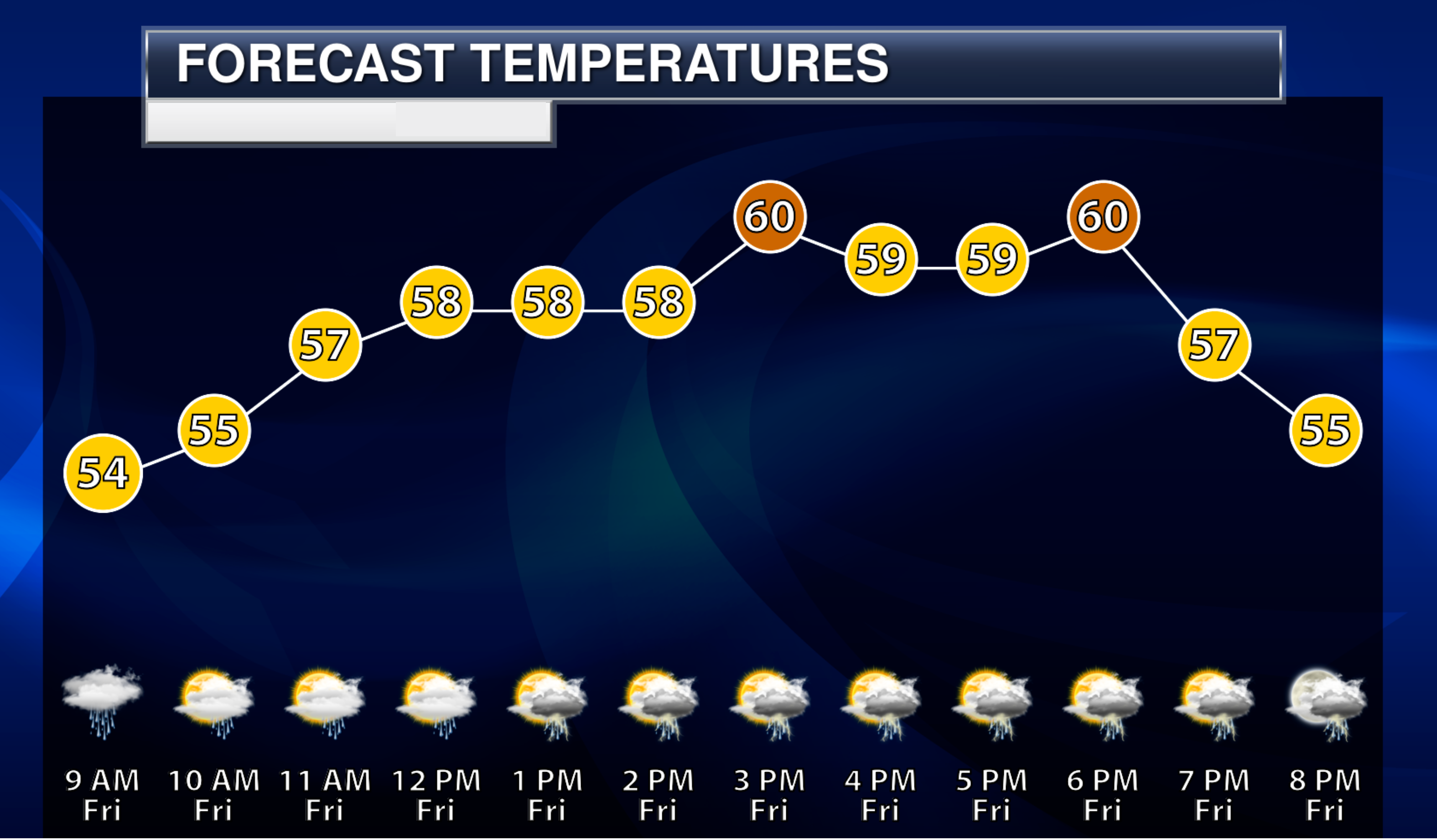
Temperatures today. Cooler than recent days. The cold front has moved off to our east.
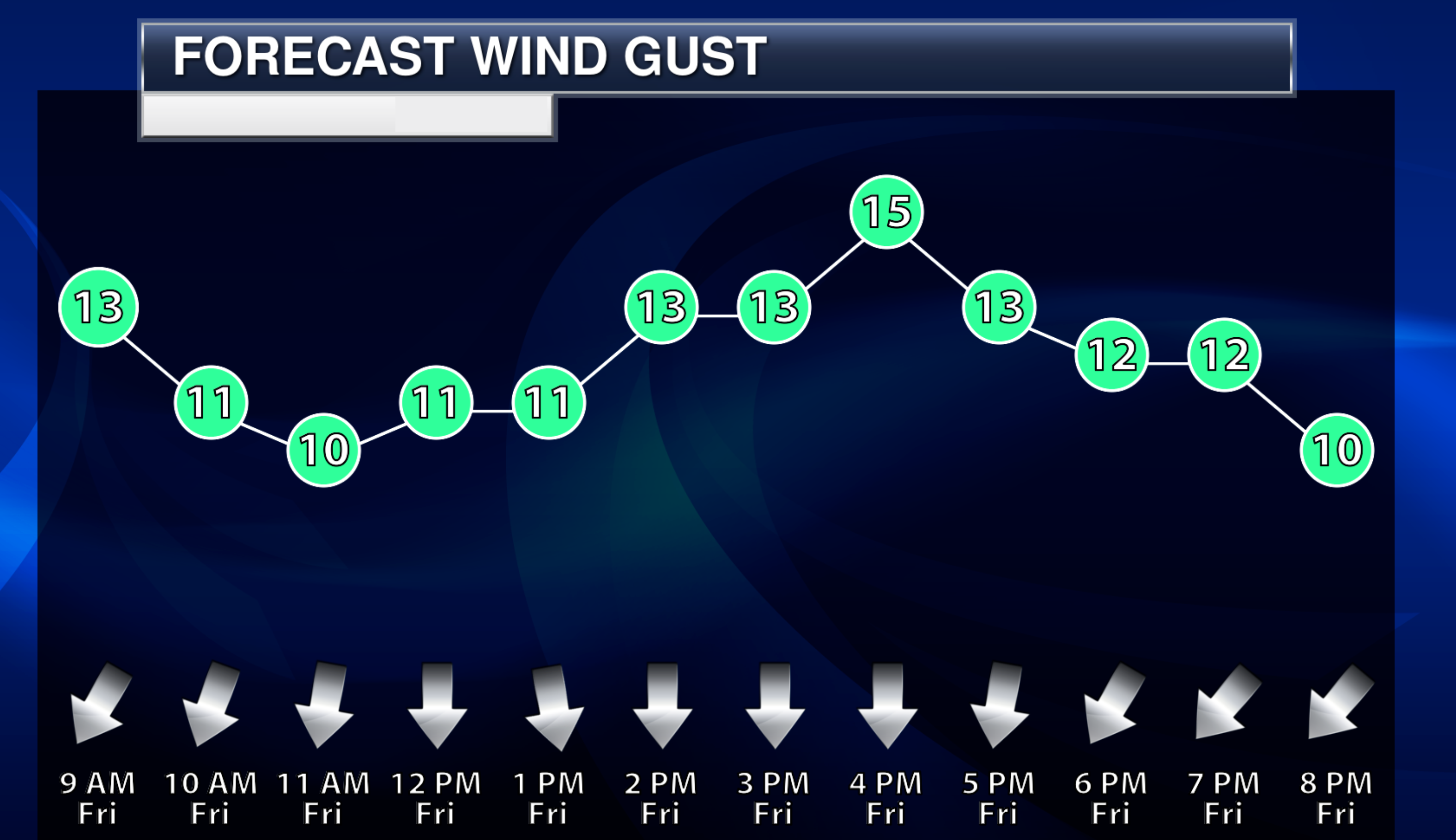
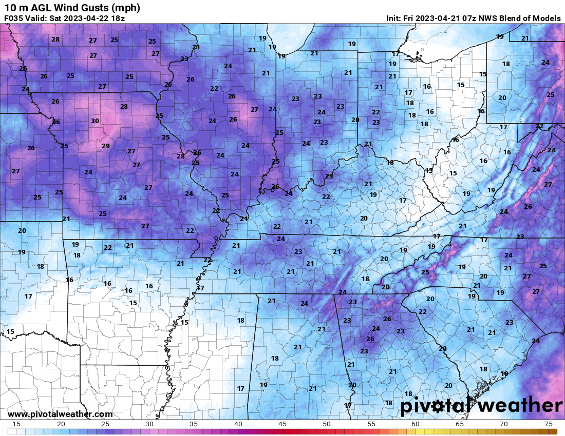
We will have some wind today, as well. Wind speeds increase tonight into Saturday.
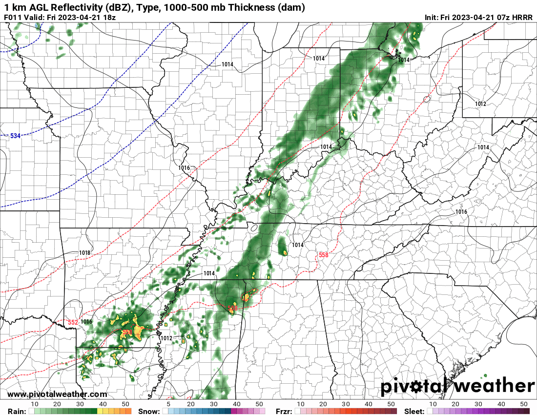
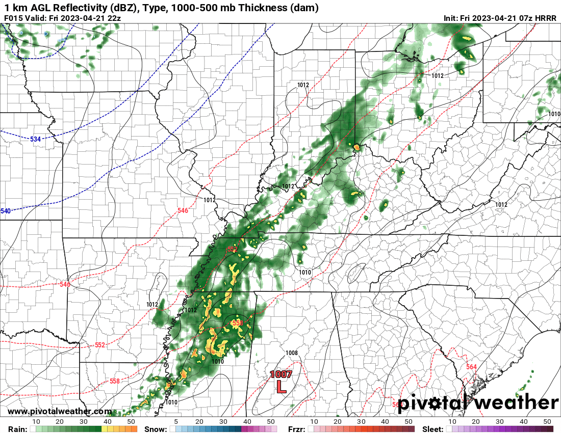
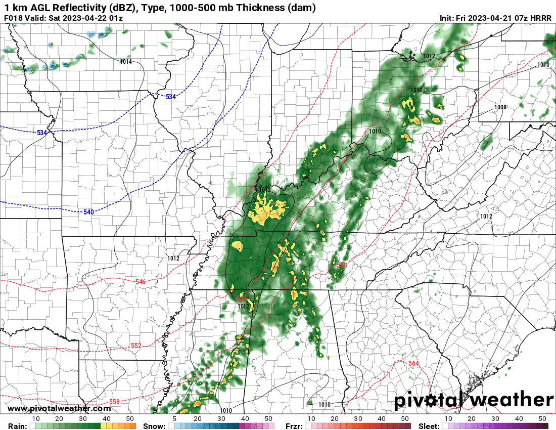
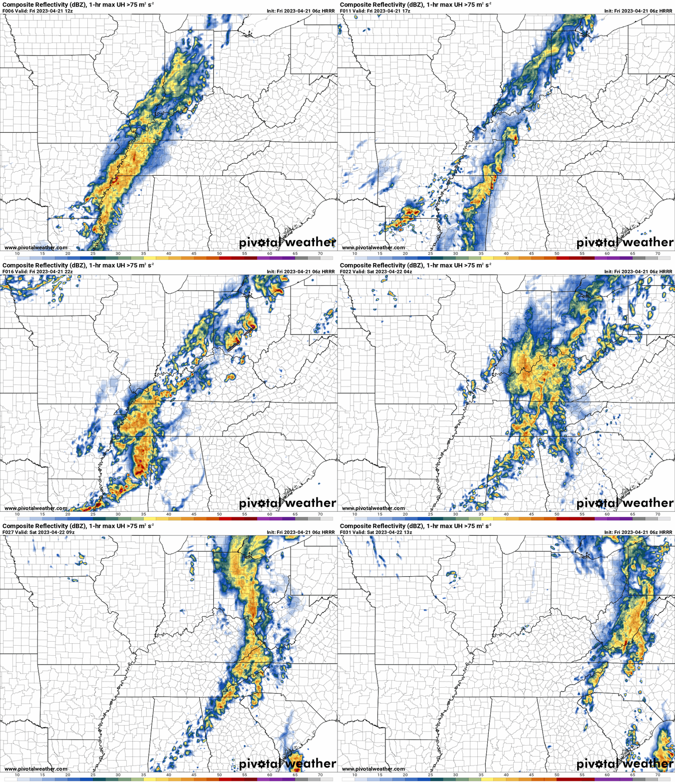
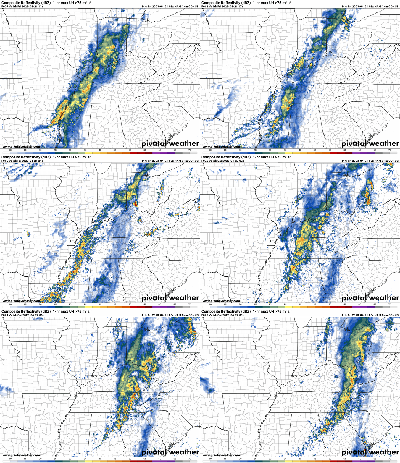
As mentioned above, the chances of rain today will be higher over our eastern counties vs western. It is possible that portions of southeast Missouri and southern Illinois end up mostly dry after this morning’s rain ends. With higher rain chances today over southeast Illinois, Kentucky, and Tennessee. See the future-cast radars below. They show it well.
Another wave of rain redevelops from the south southwest and overspreads at least Kentucky and Tennessee this afternoon and evening. Whether Missouri and Illinois receive additional rain remains uncertain. If it shifts a tad/slightly father west, then portions will receive at least some additional showers.
The bulk of the rain, however, will be over Kentucky and Tennessee. That second wave arrives after 12 PM. It will develop overhead.
1 PM future-cast radar (today)
5 PM future-cast radar
8 PM future-cast radar.
Expect lingering showers and thunderstorms into Friday night. Mainly over our eastern counties. Mainly before midnight. Then, the system will pull off to the east taking the rain with it.
I removed shower chances from Saturday’s forecast. There could be some patchy light showers before sunrise. Especially over southern Illinois and Kentucky. Those should end, however, before sunrise.
Expect partly sunny sky conditions. Intervals of sun and clouds. A few more clouds over southern Illinois and northwest Kentucky vs the rest of the region.
It will be cooler and breezy Saturday. It will be quite a bit cooler than recent days. Gone are the 80s. Those will be replaced with 50s and lower 60s. Combined with wind, it will feel cool outside. Not the best weather for outdoor events.
Saturday winds
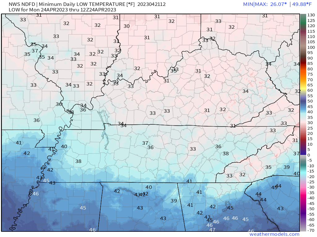
I am watching Saturday and Sunday night’s low temperatures. If the wind were to subside, then there will be a chance of frost. That would be more likely Sunday night vs Saturday night.
Overnight lows are expected to dip into the 30s. Whether we can achieve low to middle 30s will need to be monitored. Then, the wind would also have to subside in order for frost to form. Monitor updates if you have sensitive plants.
Sunday morning lows. Low chance of frost Sunday morning because of wind. Perhaps some scattered/patchy frost where winds do subside.
Double click on the images to enlarge them.
Monday Morning lows (patchy frost)
Frost chances will be a tad higher Monday morning. Winds should subside Sunday night/Monday morning.
Another chance of showers and thunderstorms will return to the forecast Tuesday into Thursday. Chances may be a tad higher Wednesday into Thursday vs Tuesday. I am still working out the details on that particular system.
At this time, the threat of severe weather appears limited next week, but I will monitor that portion of the forecast. It is spring and it doesn’t take much instability to cause the threat of severe weather to increase.
.
Click here if you would like to return to the top of the page.
This outlook covers southeast Missouri, southern Illinois, western Kentucky, and far northwest Tennessee.
Today through April 18th: A couple of the Saturday afternoon and night thunderstorms could produce damaging wind and hail. The tornado risk is low, but not zero. Mainly over Missouri for the tornado risk. The line will weaken with time as it moves farther east.
.
Today’s Storm Prediction Center’s Severe Weather Outlook
Light green is where thunderstorms may occur but should be below severe levels.
Dark green is a level one risk. Yellow is a level two risk. Orange is a level three (enhanced) risk. Red is a level four (moderate) risk. Pink is a level five (high) risk.
One is the lowest risk. Five is the highest risk.
A severe storm is one that produces 58 mph wind or higher, quarter size hail, and/or a tornado.
Explanation of tables. Click here.

.
Tornado Probability Outlook

.
Large Hail Probability Outlook

.
High wind Probability Outlook

.
Tomorrow’s severe weather outlook.

.
Day Three Severe Weather Outlook

.

.
The images below are from NOAA’s Weather Prediction Center.
24-hour precipitation outlook..
** THESE DID NOT UPDATE TODAY (IGNORE THEM) **
 .
.
.
48-hour precipitation outlook.
** THESE DID NOT UPDATE TODAY (IGNORE THEM) **
. .
.
![]()
_______________________________________
.

Click here if you would like to return to the top of the page.
Again, as a reminder, these are models. They are never 100% accurate. Take the general idea from them.
What should I take from these?
- The general idea and not specifics. Models usually do well with the generalities.
- The time-stamp is located in the upper left corner.
.
What am I looking at?
You are looking at computer model data. Meteorologists use many different models to forecast the weather.
Occasionally, these maps are in Zulu time. 12z=7 AM. 18z=1 PM. 00z=7 PM. 06z=1 AM
Green represents light rain. Dark green represents moderate rain. Yellow and orange represent heavier rain.
This animation is the Hrrr Model.
This animation is the NAM Model.
Occasionally, these maps are in Zulu time. 12z=7 AM. 18z=1 PM. 00z=7 PM. 06z=1 AM
.
.
..![]()

.
Click here if you would like to return to the top of the page.
.Average high temperatures for this time of the year are around 70 degrees.
Average low temperatures for this time of the year are around 48 degrees.
Average precipitation during this time period ranges from 0.90″ to 1.20″
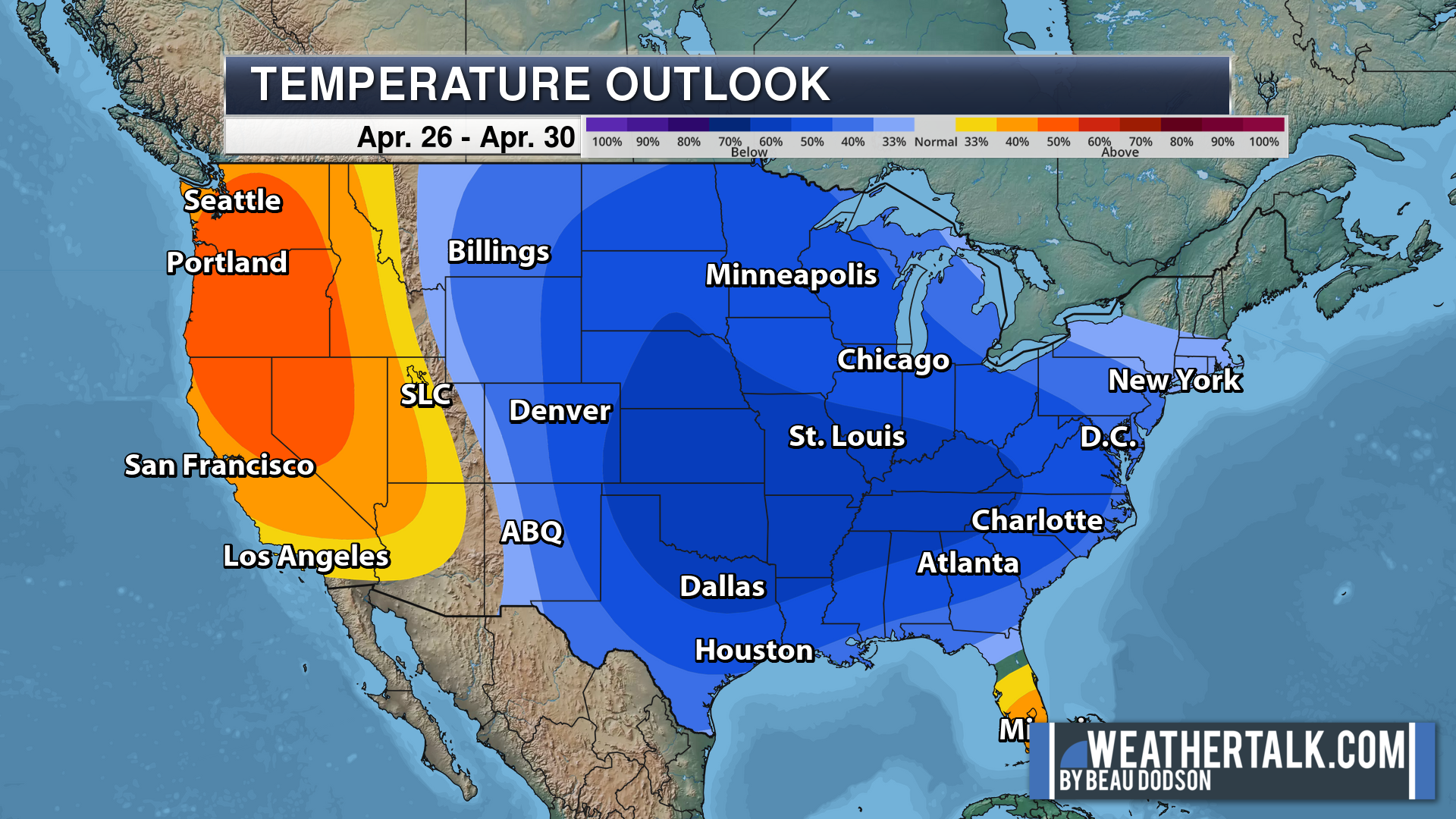
Six to Ten Day Outlook.
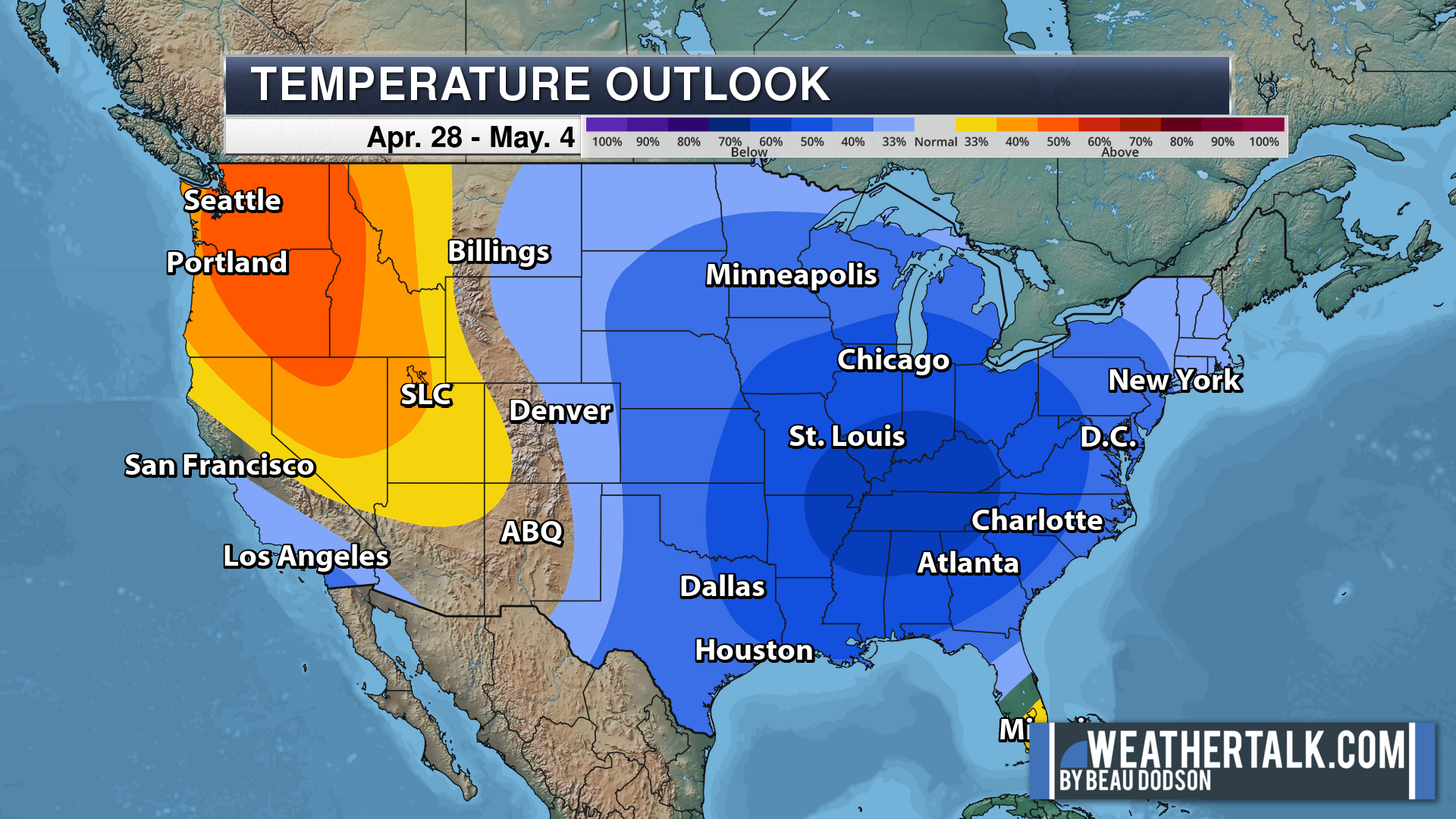
Blue is below average. Red is above average. The no color zone represents equal chances.
Average highs for this time of the year are in the lower 60s. Average lows for this time of the year are in the lower 40s.
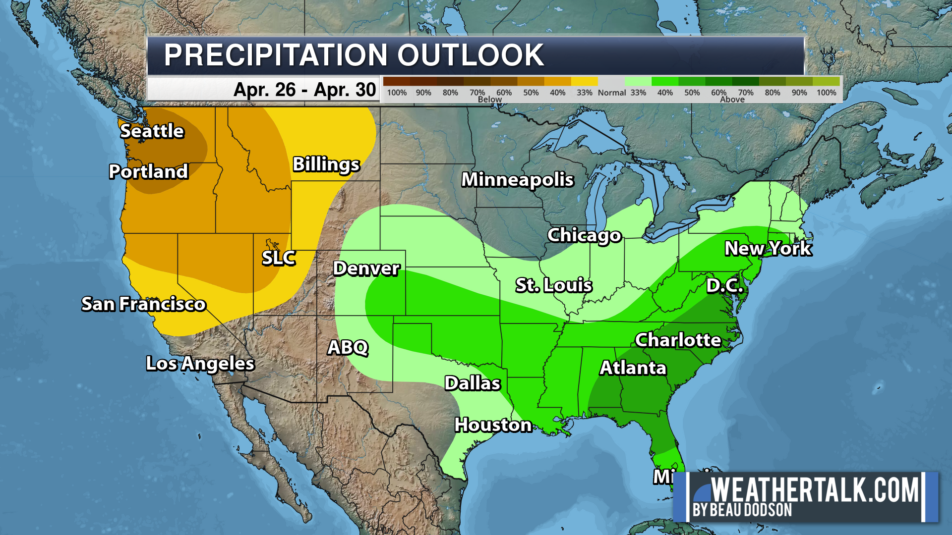
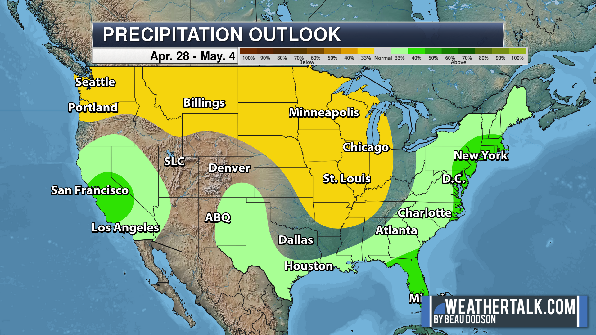
Green is above average precipitation. Yellow and brown favors below average precipitation. Average precipitation for this time of the year is around one inch per week.
.

Average low temperatures for this time of the year are around 50 degrees.
Average precipitation during this time period ranges from 1.00″ to 1.40″
.
.
![]()
The app is for subscribers. Subscribe at www.weathertalk.com/welcome then go to your app store and search for WeatherTalk
Subscribers, PLEASE USE THE APP. ATT and Verizon are not reliable during severe weather. They are delaying text messages.
The app is under WeatherTalk in the app store.
Apple users click here
Android users click here
.

Radars and Lightning Data
Interactive-city-view radars. Clickable watches and warnings.
https://wtalk.co/B3XHASFZ
If the radar is not updating then try another one. If a radar does not appear to be refreshing then hit Ctrl F5. You may also try restarting your browser.
Backup radar site in case the above one is not working.
https://weathertalk.com/morani
Regional Radar
https://imagery.weathertalk.com/prx/RadarLoop.mp4
** NEW ** Zoom radar with chaser tracking abilities!
ZoomRadar
Lightning Data (zoom in and out of your local area)
https://wtalk.co/WJ3SN5UZ
Not working? Email me at beaudodson@usawx.com
National map of weather watches and warnings. Click here.
Storm Prediction Center. Click here.
Weather Prediction Center. Click here.
.

Live lightning data: Click here.
Real time lightning data (another one) https://map.blitzortung.org/#5.02/37.95/-86.99
Our new Zoom radar with storm chases
.
.

Interactive GOES R satellite. Track clouds. Click here.
GOES 16 slider tool. Click here.
College of DuPage satellites. Click here
.

Here are the latest local river stage forecast numbers Click Here.
Here are the latest lake stage forecast numbers for Kentucky Lake and Lake Barkley Click Here.
.
.
Find Beau on Facebook! Click the banner.








 .
.