
Click one of the links below to take you directly to that section
Do you have any suggestions or comments? Email me at beaudodson@usawx.com
.
.
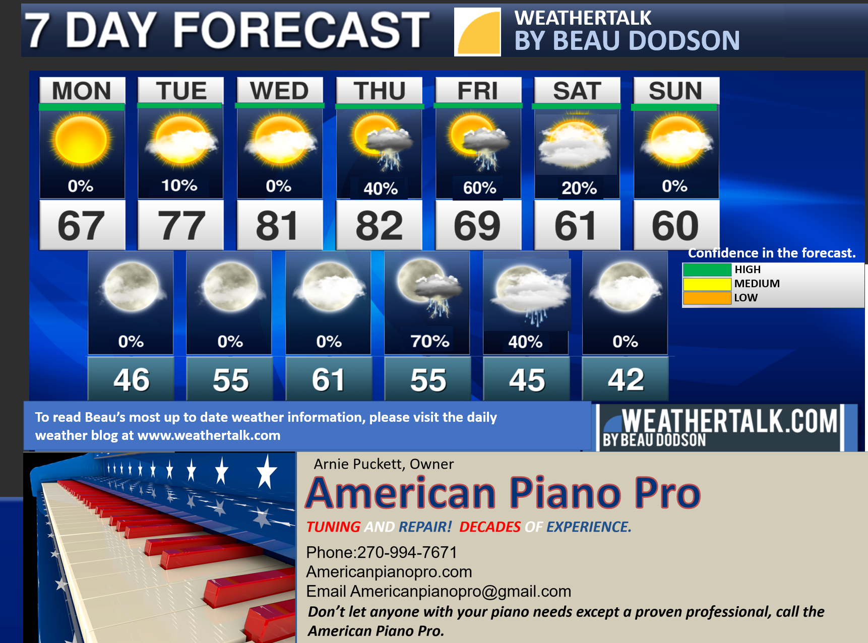
Seven-day forecast for southeast Missouri, southern Illinois, western Kentucky, and western Tennessee.
This is a BLEND for the region. Scroll down to see the region by region forecast.
THE FORECAST IS GOING TO VARY FROM LOCATION TO LOCATION. Scroll down to see the region by region forecast.
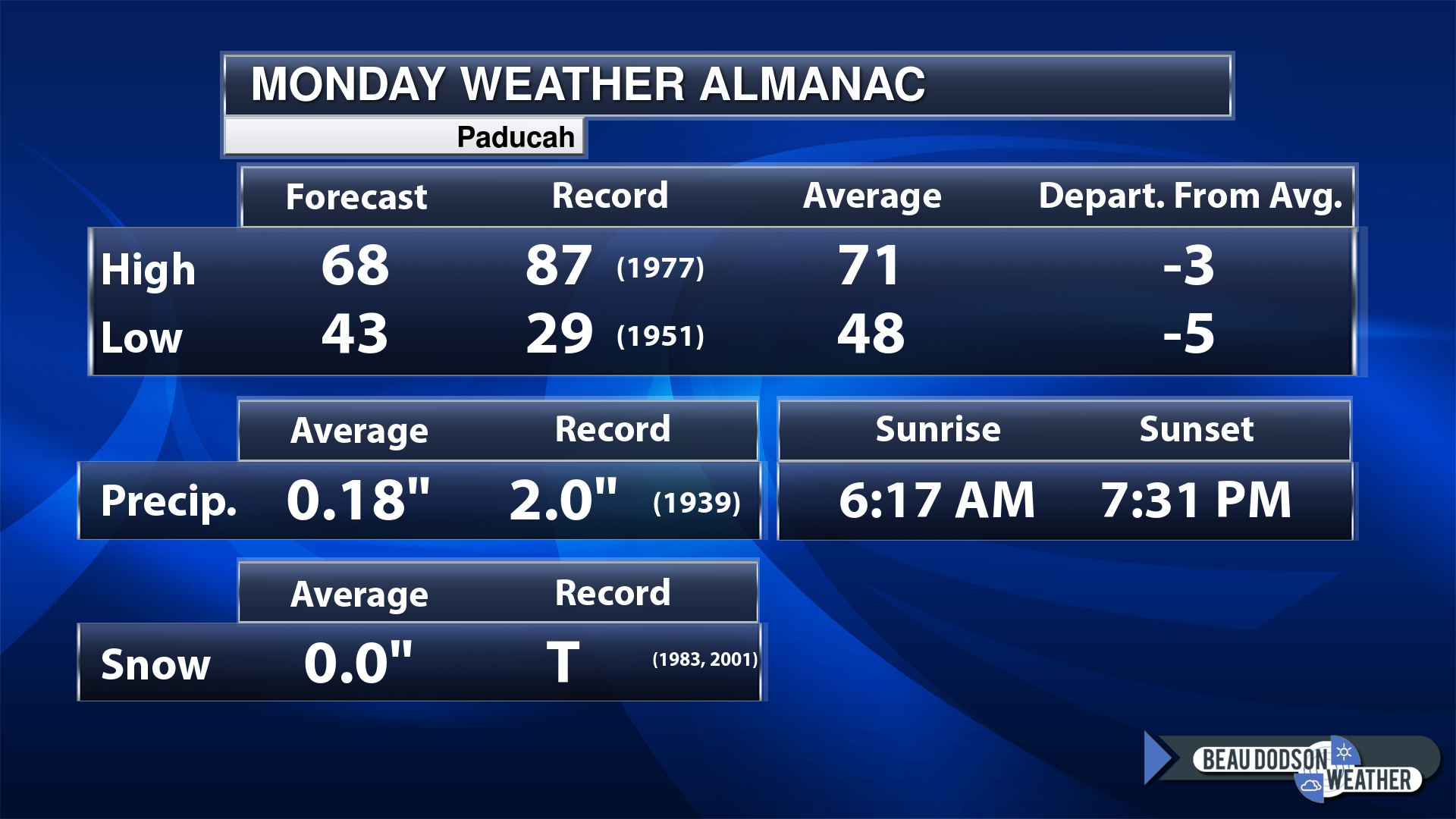
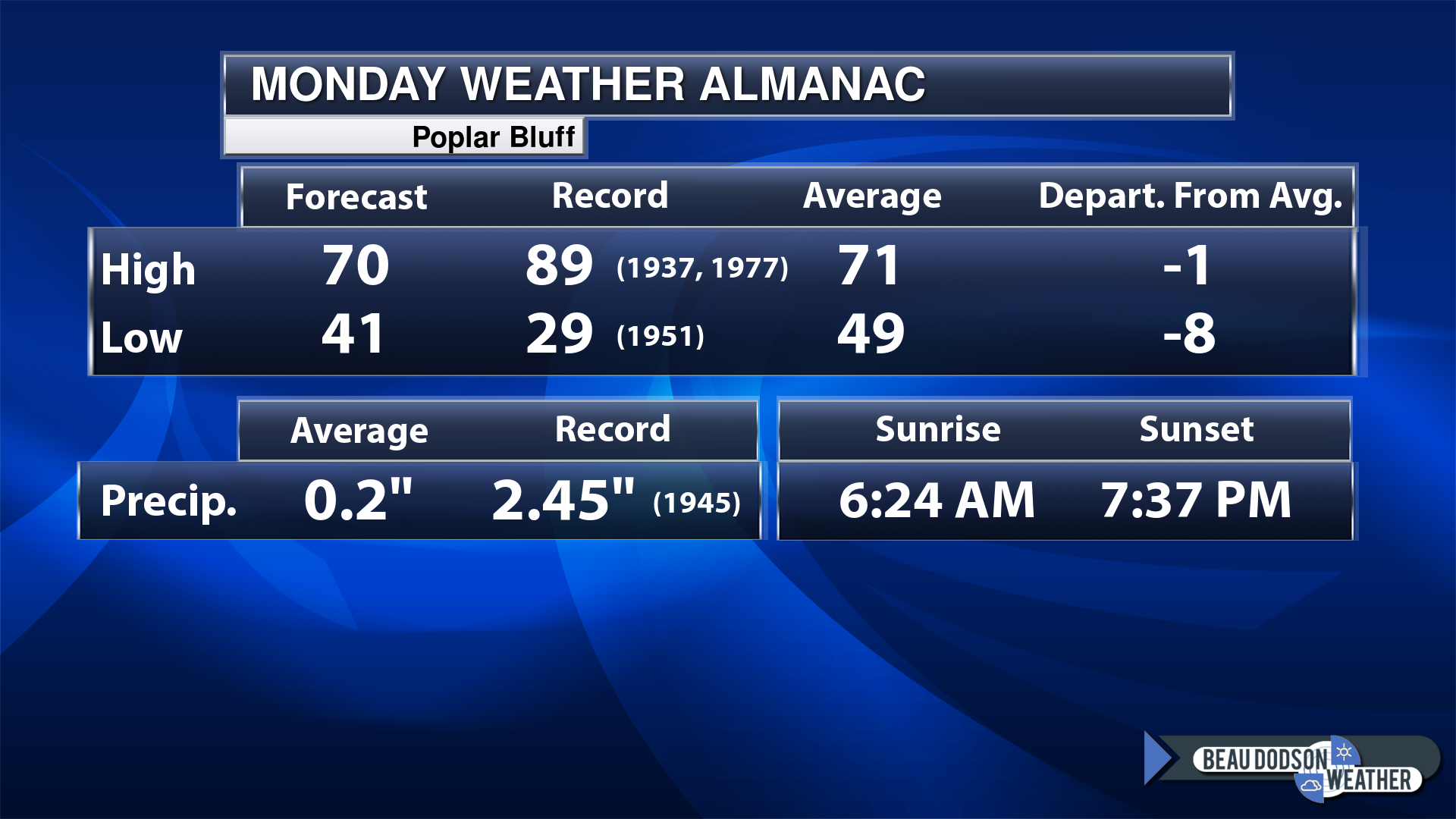
Today’s Local Almanacs (for a few select cities). Your location will be comparable.
Note, the low is this morning’s low and not tomorrows.
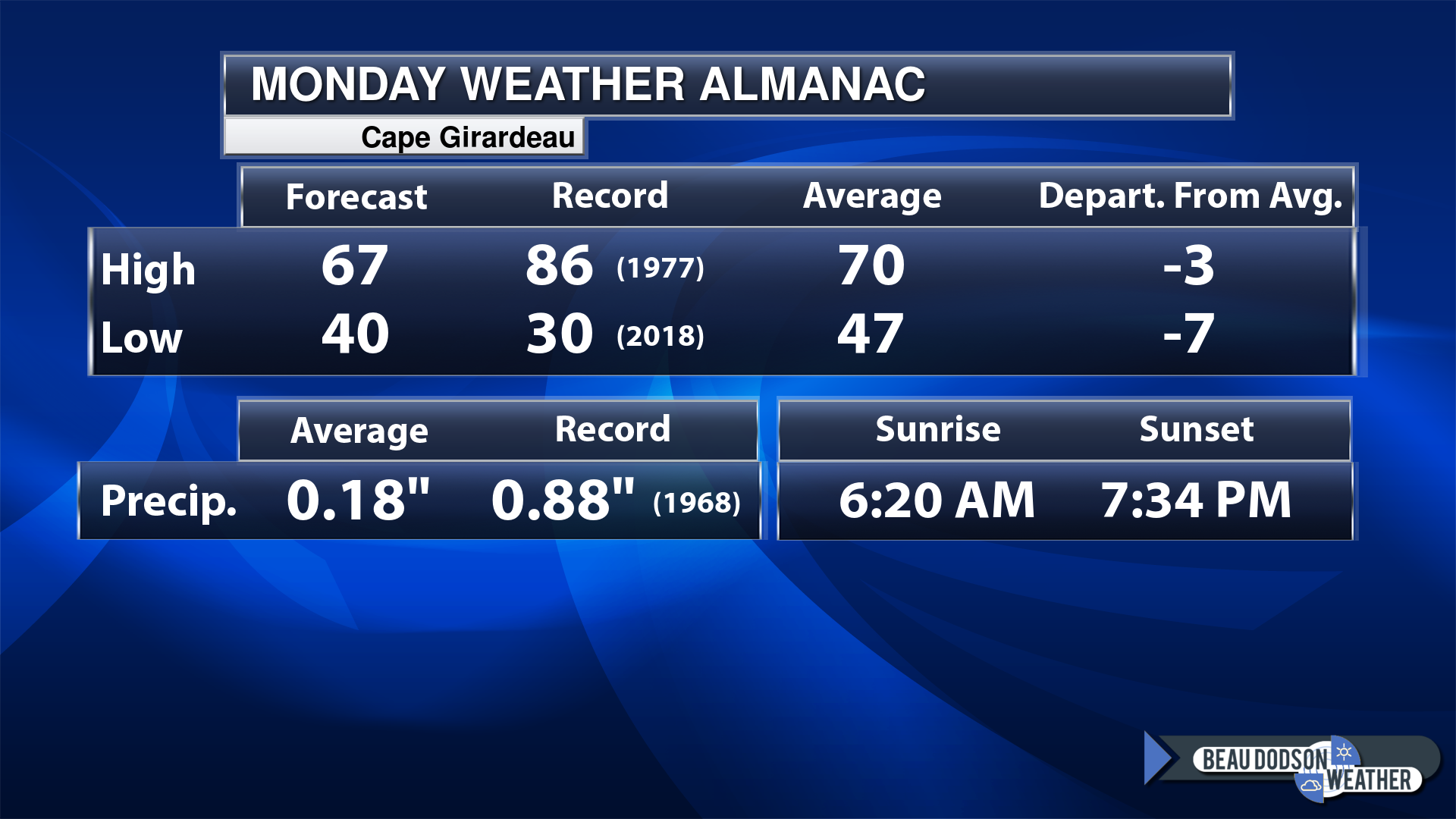
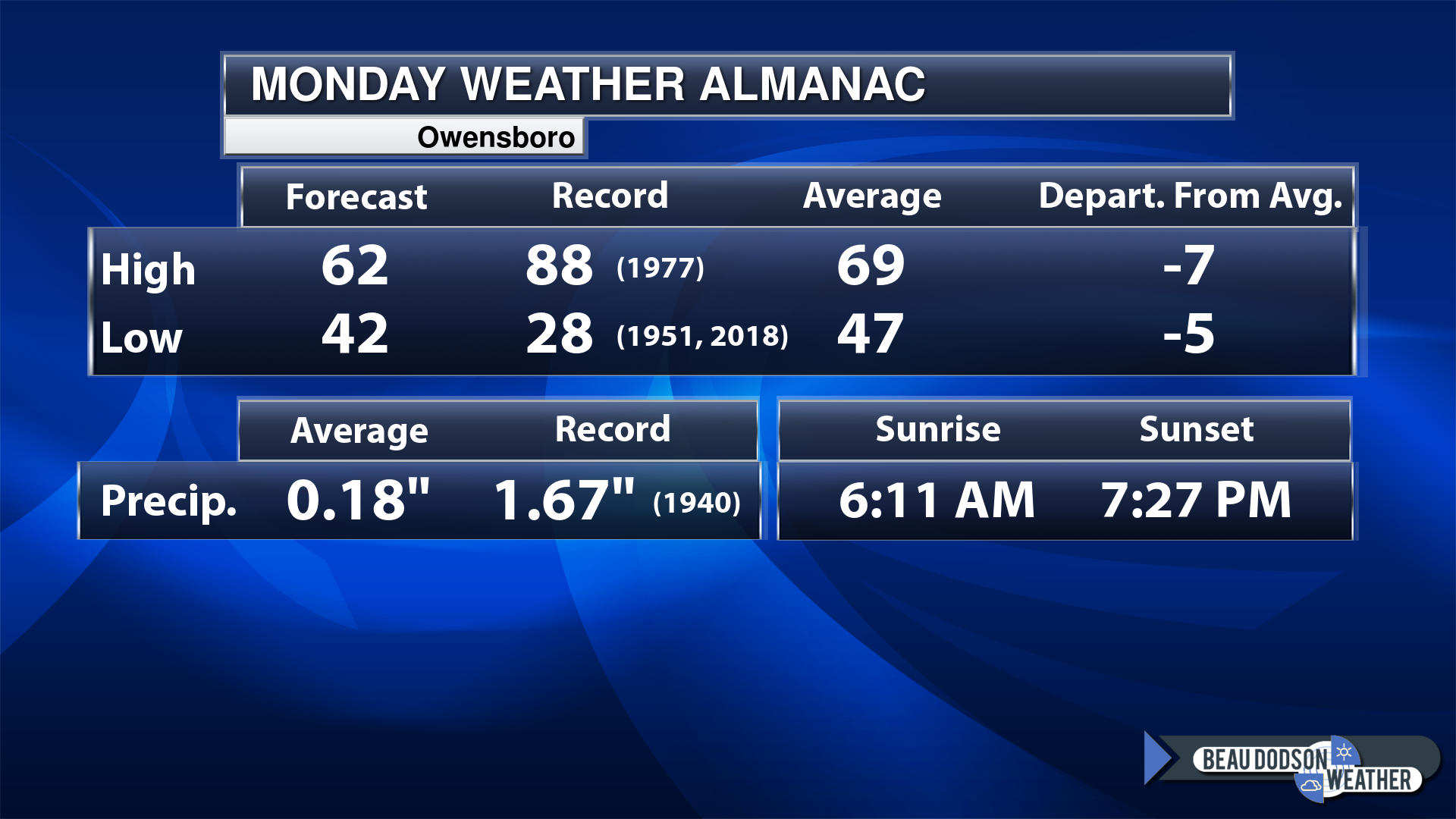
Today’s almanac numbers from a few select local cities.
The forecast temperature shows you today’s expected high and this morning’s low.
The graphic shows you the record high and record low for today. It shows you what year that occurred, as well.
It then shows you what today’s average temperature is.
Then, it shows you the departures (how many degrees above or below average temperatures will be).
It shows you the average precipitation for today. Average comes from thirty years of rain totals.
It also shows you the record rainfall for the date and what year that occurred.
The sunrise and sunset is also shown.
If you have not subscribed to my YouTube Channel then click on this link and it will take you to my videos.
Click the button below and it will take you to the Beau Dodson YouTube Channel.
48-hour forecast


.

.
Monday to Monday
1. Is lightning in the forecast? Yes. Lightning is possible Thursday into Friday.
2. Are severe thunderstorms in the forecast? Possible. A few of the thunderstorms could be severe Thursday afternoon and Thursday night. The risk may be a tad higher over Missouri vs the rest of the area. Monitor updates.
3. Is flash flooding in the forecast? Unlikely. I will keep an eye on Thursday and Thursday. If a few storms train over the same area, then perhaps isolated flash flooding. Similar to the last event. Severe thunderstorms can drop much higher rain totals.
4. Will the heat index exceed 100 degrees? No.
5. Will the wind chill dip below 10 degrees? No.
6. Is measurable snow and/or sleet in the forecast? No.
7. Is freezing rain/ice in the forecast? No.
Freezing rain is rain that falls and instantly freezes on objects such as trees and power lines
.
Monday, April 17, 2023
Confidence in the forecast? High Confidence
Monday Forecast: Mostly sunny.
What is the chance of precipitation?
Far northern southeast Missouri ~ 0%
Southeast Missouri ~ 0%
The Missouri Bootheel ~ 0%
I-64 Corridor of southern Illinois ~ 0%
Southern Illinois ~ 0%
Extreme southern Illinois (southern seven counties) ~ 0%
Far western Kentucky ~ 0%
The Pennyrile area of western KY ~ 0%
Northwest Kentucky (near Indiana border) ~ 0%
Northwest Tennessee ~ 0%
Coverage of precipitation:
Timing of the precipitation:
Temperature range:
Far northern southeast Missouri ~ 62° to 65°
Southeast Missouri ~ 63° to 66°
The Missouri Bootheel ~ 64° to 68°
I-64 Corridor of southern Illinois ~ 62° to 65°
Southern Illinois ~ 64° to 66°
Extreme southern Illinois (southern seven counties) ~ 64° to 68°
Far western Kentucky ~ 64° to 66°
The Pennyrile area of western KY ~ 64° to 66°
Northwest Kentucky (near Indiana border) ~ 63° to 66°
Northwest Tennessee ~ 63° to 66°
Winds will be from this direction: West 10 to 20 mph. Gusty.
Wind chill or heat index (feels like) temperature forecast: 60° to 65°
What impacts are anticipated from the weather?
Should I cancel my outdoor plans? No
UV Index: 8. Very high.
Sunrise: 6:18 AM
Sunset: 7:32 PM
.
Monday night Forecast: Partly cloudy.
What is the chance of precipitation?
Far northern southeast Missouri ~ 0%
Southeast Missouri ~ 0%
The Missouri Bootheel ~ 0%
I-64 Corridor of southern Illinois ~ 0%
Southern Illinois ~ 0%
Extreme southern Illinois (southern seven counties) ~ 0%
Far western Kentucky ~ 0%
The Pennyrile area of western KY ~ 0%
Northwest Kentucky (near Indiana border) ~ 0%
Northwest Tennessee ~ 0%
Coverage of precipitation:
Timing of the precipitation:
Temperature range:
Far northern southeast Missouri ~40° to 45°
Southeast Missouri ~ 42° to 45°
The Missouri Bootheel ~ 44° to 46°
I-64 Corridor of southern Illinois ~ 40° to 42°
Southern Illinois ~ 42° to 45°
Extreme southern Illinois (southern seven counties) ~ 42° to 45°
Far western Kentucky ~ 42° to 45°
The Pennyrile area of western KY ~ 42° to 45°
Northwest Kentucky (near Indiana border) ~ 42° to 45°
Northwest Tennessee ~ 43° to 46°
Winds will be from this direction: West northwest 8 to 16 mph
Wind chill or heat index (feels like) temperature forecast: 40° to 45°
What impacts are anticipated from the weather?
Should I cancel my outdoor plans? No
Moonrise: 5:08 AM
Moonset: 4:52 PM
The phase of the moon: Waning Crescent
.
Tuesday, April 18, 2023
Confidence in the forecast? High Confidence
Tuesday Forecast: Partly sunny.
What is the chance of precipitation?
Far northern southeast Missouri ~ 0%
Southeast Missouri ~ 0%
The Missouri Bootheel ~ 0%
I-64 Corridor of southern Illinois ~ 0%
Southern Illinois ~ 0%
Extreme southern Illinois (southern seven counties) ~ 0%
Far western Kentucky ~ 0%
The Pennyrile area of western KY ~ 0%
Northwest Kentucky (near Indiana border) ~ 0%
Northwest Tennessee ~ 0%
Coverage of precipitation:
Timing of the precipitation:
Temperature range:
Far northern southeast Missouri ~ 70° to 75°
Southeast Missouri ~ 70° to 75°
The Missouri Bootheel ~ 73° to 76°
I-64 Corridor of southern Illinois ~ 70° to 75°
Southern Illinois ~ 70° to 75°
Extreme southern Illinois (southern seven counties) ~ 70° to 75°
Far western Kentucky ~ 72° to 75°
The Pennyrile area of western KY ~ 72° to 75°
Northwest Kentucky (near Indiana border) ~ 70° to 75°
Northwest Tennessee ~ 74° to 76°
Winds will be from this direction: South 8 to 16 mph.
Wind chill or heat index (feels like) temperature forecast: 70° to 75°
What impacts are anticipated from the weather?
Should I cancel my outdoor plans? No
UV Index: 8. Very high.
Sunrise: 6:17 AM
Sunset: 7:34 PM
.
Tuesday night Forecast: Partly cloudy.
What is the chance of precipitation?
Far northern southeast Missouri ~ 0%
Southeast Missouri ~ 0%
The Missouri Bootheel ~ 0%
I-64 Corridor of southern Illinois ~ 0%
Southern Illinois ~ 0%
Extreme southern Illinois (southern seven counties) ~ 0%
Far western Kentucky ~ 0%
The Pennyrile area of western KY ~ 0%
Northwest Kentucky (near Indiana border) ~ 0%
Northwest Tennessee ~ 0%
Coverage of precipitation:
Timing of the precipitation:
Temperature range:
Far northern southeast Missouri ~ 53° to 56°
Southeast Missouri ~ 53° to 56°
The Missouri Bootheel ~ 53° to 56°
I-64 Corridor of southern Illinois ~ 53° to 56°
Southern Illinois ~ 53° to 56°
Extreme southern Illinois (southern seven counties) ~ 53° to 56°
Far western Kentucky ~ 53° to 56°
The Pennyrile area of western KY ~ 53° to 56°
Northwest Kentucky (near Indiana border) ~ 53° to 56°
Northwest Tennessee ~ 53° to 56°
Winds will be from this direction: Southwest 6 to 12 mph
Wind chill or heat index (feels like) temperature forecast: 53° to 56°
What impacts are anticipated from the weather?
Should I cancel my outdoor plans? No
Moonrise: 5:35 AM
Moonset: 6:08 PM
The phase of the moon: Waning Crescent
.
Wednesday, April 19, 2023
Confidence in the forecast? High Confidence
Wednesday Forecast: Partly sunny.
What is the chance of precipitation?
Far northern southeast Missouri ~ 0%
Southeast Missouri ~ 0%
The Missouri Bootheel ~ 0%
I-64 Corridor of southern Illinois ~ 0%
Southern Illinois ~ 0%
Extreme southern Illinois (southern seven counties) ~ 0%
Far western Kentucky ~ 0%
The Pennyrile area of western KY ~ 0%
Northwest Kentucky (near Indiana border) ~ 0%
Northwest Tennessee ~ 0%
Coverage of precipitation:
Timing of the precipitation:
Temperature range:
Far northern southeast Missouri ~ 76° to 80°
Southeast Missouri ~ 76° to 80°
The Missouri Bootheel ~ 78° to 82°
I-64 Corridor of southern Illinois ~ 76° to 80°
Southern Illinois ~ 76° to 80°
Extreme southern Illinois (southern seven counties) ~ 76° to 80°
Far western Kentucky ~ 76° to 80°
The Pennyrile area of western KY ~ 76° to 80°
Northwest Kentucky (near Indiana border) ~ 76° to 80°
Northwest Tennessee ~ 78° to 82°
Winds will be from this direction: South 15 to 30 mph. Gusty.
Wind chill or heat index (feels like) temperature forecast: 75° to 82°
What impacts are anticipated from the weather?
Should I cancel my outdoor plans? No
UV Index: 8. Very high.
Sunrise: 6:16 AM
Sunset: 7:34 PM
.
Wednesday night Forecast: Partly cloudy.
What is the chance of precipitation?
Far northern southeast Missouri ~ 0%
Southeast Missouri ~ 0%
The Missouri Bootheel ~ 0%
I-64 Corridor of southern Illinois ~ 0%
Southern Illinois ~ 0%
Extreme southern Illinois (southern seven counties) ~ 0%
Far western Kentucky ~ 0%
The Pennyrile area of western KY ~ 0%
Northwest Kentucky (near Indiana border) ~ 0%
Northwest Tennessee ~ 0%
Coverage of precipitation:
Timing of the precipitation:
Temperature range:
Far northern southeast Missouri ~ 58° to 62°
Southeast Missouri ~ 58° to 62°
The Missouri Bootheel ~ 58° to 62°
I-64 Corridor of southern Illinois ~ 58° to 62°
Southern Illinois ~ 58° to 62°
Extreme southern Illinois (southern seven counties) ~ 58° to 62°
Far western Kentucky ~ 58° to 62°
The Pennyrile area of western KY ~ 58° to 62°
Northwest Kentucky (near Indiana border) ~ 58° to 62°
Northwest Tennessee ~ 58° to 62°
Winds will be from this direction: South 15 to 25 mph
Wind chill or heat index (feels like) temperature forecast: 58° to 62°
What impacts are anticipated from the weather?
Should I cancel my outdoor plans? No
Moonrise: 6:02 AM
Moonset: 7:16 PM
The phase of the moon: New
.
Thursday, April 20, 2023
Confidence in the forecast? High Confidence
Thursday Forecast: Thickening clouds. A chance of showers and thunderstorms. Increasing chances from the west.
What is the chance of precipitation?
Far northern southeast Missouri ~ 60%
Southeast Missouri ~ 60%
The Missouri Bootheel ~ 60%
I-64 Corridor of southern Illinois ~ 40%
Southern Illinois ~ 40%
Extreme southern Illinois (southern seven counties) ~ 40%
Far western Kentucky ~ 40%
The Pennyrile area of western KY ~ 30%
Northwest Kentucky (near Indiana border) ~ 40%
Northwest Tennessee ~ 40%
Coverage of precipitation: Scattered
Timing of the precipitation: Any given point of time, but more likely after lunch.
Temperature range:
Far northern southeast Missouri ~ 76° to 80°
Southeast Missouri ~ 76° to 80°
The Missouri Bootheel ~ 78° to 82°
I-64 Corridor of southern Illinois ~ 76° to 80°
Southern Illinois ~ 76° to 80°
Extreme southern Illinois (southern seven counties) ~ 76° to 80°
Far western Kentucky ~ 76° to 80°
The Pennyrile area of western KY ~ 76° to 80°
Northwest Kentucky (near Indiana border) ~ 76° to 80°
Northwest Tennessee ~ 78° to 82°
Winds will be from this direction: South 15 to 30 mph. Gusty.
Wind chill or heat index (feels like) temperature forecast: 75° to 82°
What impacts are anticipated from the weather? Wet roadways. Lightning. Monitor the risk of intense storms.
Should I cancel my outdoor plans? No, but check the Beau Dodson Weather Radars
UV Index: 7. High.
Sunrise: 6:14 AM
Sunset: 7:35 PM
.
Wednesday night Forecast: Mostly cloudy. Showers and thunderstorms likely.
What is the chance of precipitation?
Far northern southeast Missouri ~ 80%
Southeast Missouri ~ 80%
The Missouri Bootheel ~ 80%
I-64 Corridor of southern Illinois ~ 80%
Southern Illinois ~ 80%
Extreme southern Illinois (southern seven counties) ~ 80%
Far western Kentucky ~ 80%
The Pennyrile area of western KY ~ 80%
Northwest Kentucky (near Indiana border) ~ 80%
Northwest Tennessee ~ 80%
Coverage of precipitation: Numerous
Timing of the precipitation: Any given point of time
Temperature range:
Far northern southeast Missouri ~ 54° to 58°
Southeast Missouri ~ 54° to 58°
The Missouri Bootheel ~ 54° to 58°
I-64 Corridor of southern Illinois ~ 54° to 58°
Southern Illinois ~ 54° to 58°
Extreme southern Illinois (southern seven counties) ~ 54° to 58°
Far western Kentucky ~ 54° to 58°
The Pennyrile area of western KY ~ 54° to 58°
Northwest Kentucky (near Indiana border) ~ 54° to 58°
Northwest Tennessee ~ 54° to 58°
Winds will be from this direction: South 15 to 30 mph
Wind chill or heat index (feels like) temperature forecast: 50° to 55°
What impacts are anticipated from the weather? Wet roadways. Lightning. A few storms could be intense.
Should I cancel my outdoor plans? Yes. Check the Beau Dodson Weather Radars.
Moonrise: 6:30 AM
Moonset: 8:26 PM
The phase of the moon: New
Click here if you would like to return to the top of the page.
-
- Warming trend through Thursday. Cooler weekend.
- Nice weather today through Wednesday.
- Thunderstorm chances ramp up Thursday into Friday (focused on Thursday afternoon/night).
- A few storms could be severe Thursday afternoon and night.
Weather advice:
As we prepare for spring, let’s make sure you have three to five ways of receiving your severe weather information.
.
Forecast Discussion
I hope you had a nice weekend. Saturday was a stormy one! Quite a few hail reports in the region. A large swath of small hail spread across Massac and Pope Counties. The ground was white in some areas.
You may have heard a loud roar. That was a hail roar. It happens with large heavy hail swaths. It can sound like a tornado.
That system is long gone and has been replaced with high pressure.
High pressure will continue to build into the region today and tomorrow. A tight pressure gradient will be strong and gusty winds today. Some of the gusts will top 30 mph. Perhaps above 40 mph over southeast Illinois and northwest Kentucky.
The pressure gradient will loosen up tonight. Winds will subside.
That will set the stage for temperatures to drop into the upper 30s to lower 40s. A chilly night. Not expecting a killing frost, but some light patchy frost might impact the I64 corridor.
Dry conditions today through Wednesday night.
Relative humidity will be low today and tomorrow. That increases the risk of field and brush fires. Use caution. There have been several field and brush fires over the past week.
Our next storm system develops late Wednesday night into Thursday.
An area of low pressure will develop to our west and northwest. That will help drag a cold front into the region.
That will set the stage for showers and thunderstorms to return to the forecast.
Scattered showers and thunderstorms are possible as early as the first half of Thursday. Chances will be a bit higher over Missouri at the beginning of the system.
Shower and thunderstorm chances ramp up area-wide late Thursday into Thursday night.
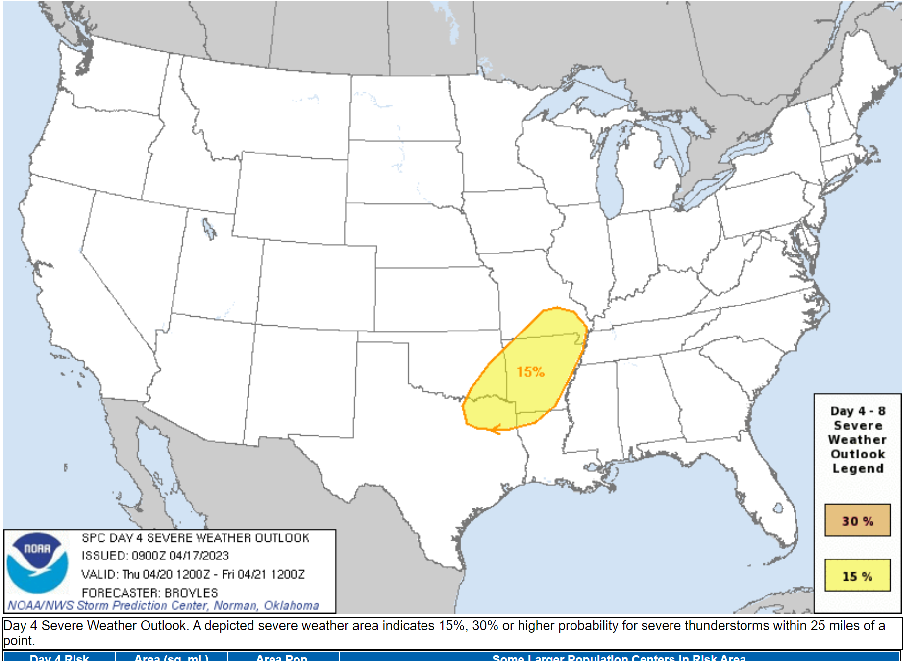
There will be some instability for thunderstorms to tap into. We have been outlined for a low-level risk of severe weather Thursday afternoon into Thursday night.
The risk will be highest over southeast Missouri and Arkansas. Again, similar to our last event.
Here is the current SPC severe weather outlook. This will likely be expanded farther east/northeast. This is a level two risk. They will likely surround that with a level 1 risk in tomorrow’s outlook.
Here is the SPC technical comments on that outlook.
Thursday/Day 4...
   An upper-level low is forecast to move into the Northern Plains on
   Thursday, as an associated trough moves eastward into the southern
   and central Plains. As the trough approaches, a southern Plains
   dryline is forecast to move quickly eastward into the western
   Ozarks, with a cold front overtaking the dryline. Surface heating
   and low-level convergence along these features will likely result in
   convective initiation during the afternoon. Thunderstorms are
   expected to develop from the mid Mississippi Valley southwestward
   across the Ozarks into northeast Texas. Moderate deep-layer shear
   and steep lapse rates near the instability axis will likely be
   favorable for severe storms during the late afternoon and evening.
   Supercells will be capable of large hail and wind damage. The more
   organized multicell line segments could also have a wind-damage
   threat.
The primary concern will be damaging wind and hail. A low end tornado risk. Similar to some of our recent events.
The peak time-frame for severe weather will likely be 4 PM through midnight Thursday. I will need to monitor the timing. The system is still four days out.
Locally heavy rain will be possible in thunderstorms, as well.
The system is forecast to slow and/or stall Thursday night. This may lead to a continuation of thunderstorm chances into Friday. There is less confidence on the Friday rain probabilities vs Thursday afternoon and night.
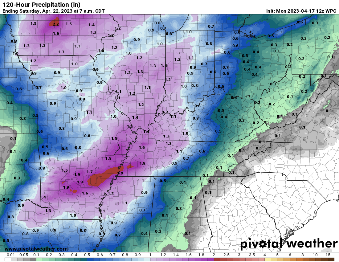
Rain totals of 0.8 to 1.60″ are likely with this system. Where training thunderstorms develop, there could be rain totals exceeding two inches.
Here is the WPC/NOAA rainfall forecast.
Double click on the image to enlarge it.
We dry out Friday night into the weekend. Cooler air will filter into the region, as well.
Windy and cooler conditions Saturday and Sunday. Some lingering clouds.
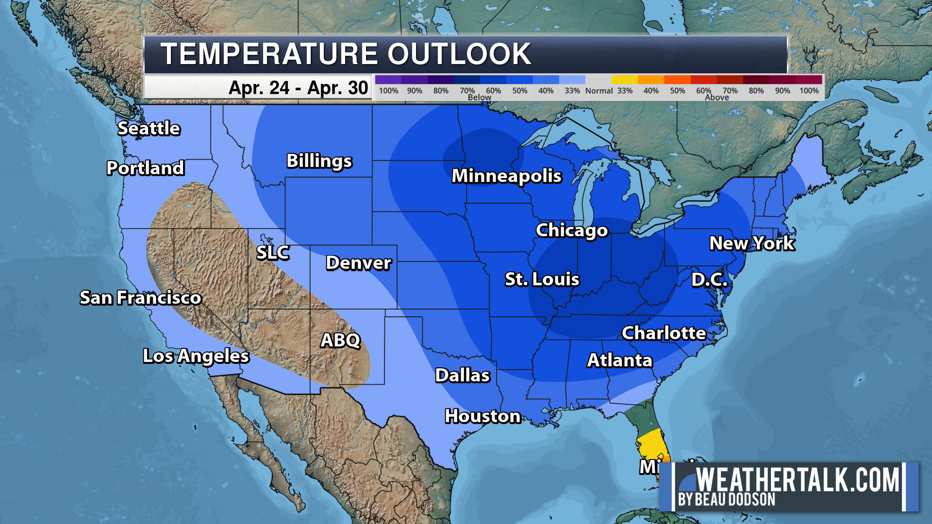
Below average temperatures are forecast next week, as well.
.
Click here if you would like to return to the top of the page.
This outlook covers southeast Missouri, southern Illinois, western Kentucky, and far northwest Tennessee.
Today through April 18th: A couple of the Saturday afternoon and night thunderstorms could produce damaging wind and hail. The tornado risk is low, but not zero. Mainly over Missouri for the tornado risk. The line will weaken with time as it moves farther east.
.
Today’s Storm Prediction Center’s Severe Weather Outlook
Light green is where thunderstorms may occur but should be below severe levels.
Dark green is a level one risk. Yellow is a level two risk. Orange is a level three (enhanced) risk. Red is a level four (moderate) risk. Pink is a level five (high) risk.
One is the lowest risk. Five is the highest risk.
A severe storm is one that produces 58 mph wind or higher, quarter size hail, and/or a tornado.
Explanation of tables. Click here.

.
Tornado Probability Outlook

.
Large Hail Probability Outlook

.
High wind Probability Outlook

.
Tomorrow’s severe weather outlook.

.
Day Three Severe Weather Outlook

.

.
The images below are from NOAA’s Weather Prediction Center.
24-hour precipitation outlook..
 .
.
.
48-hour precipitation outlook.
. .
.
![]()
_______________________________________
.

Click here if you would like to return to the top of the page.
Again, as a reminder, these are models. They are never 100% accurate. Take the general idea from them.
What should I take from these?
- The general idea and not specifics. Models usually do well with the generalities.
- The time-stamp is located in the upper left corner.
.
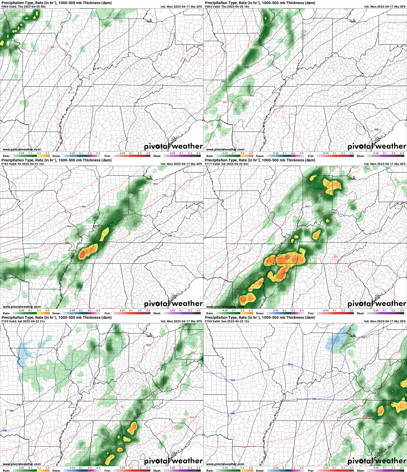
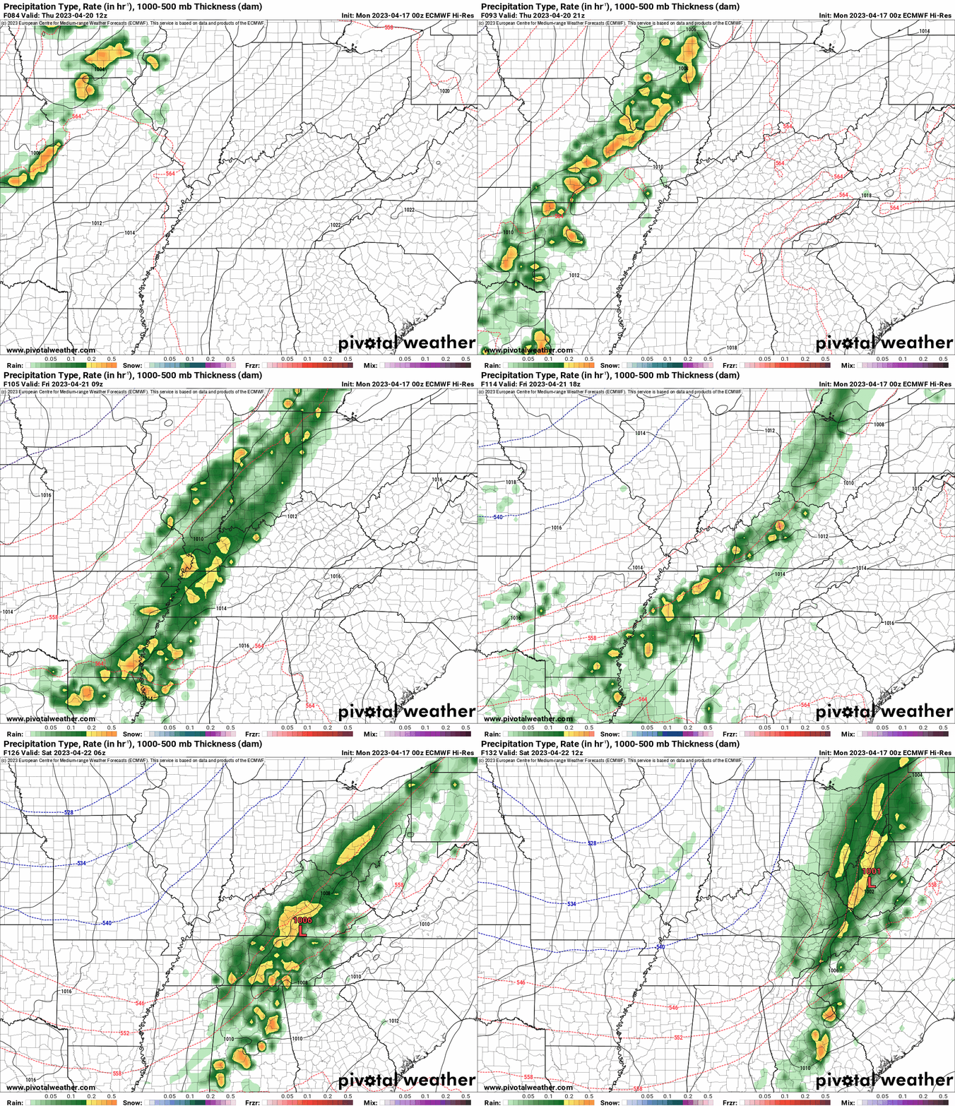
What am I looking at?
You are looking at computer model data. Meteorologists use many different models to forecast the weather.
Occasionally, these maps are in Zulu time. 12z=7 AM. 18z=1 PM. 00z=7 PM. 06z=1 AM
Green represents light rain. Dark green represents moderate rain. Yellow and orange represent heavier rain.
This animation is the GFS Model.
This animation is the EC Model.
Occasionally, these maps are in Zulu time. 12z=7 AM. 18z=1 PM. 00z=7 PM. 06z=1 AM
.
..![]()

.
Click here if you would like to return to the top of the page.
.Average high temperatures for this time of the year are around 70 degrees.
Average low temperatures for this time of the year are around 48 degrees.
Average precipitation during this time period ranges from 0.90″ to 1.20″
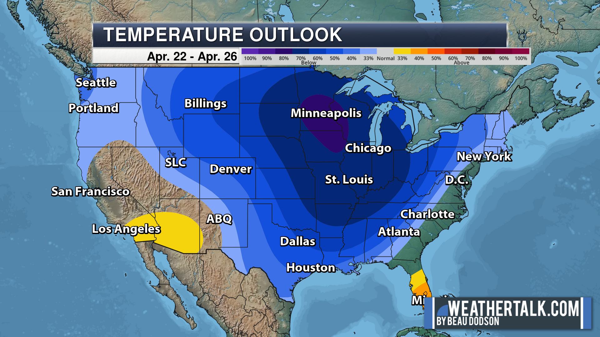
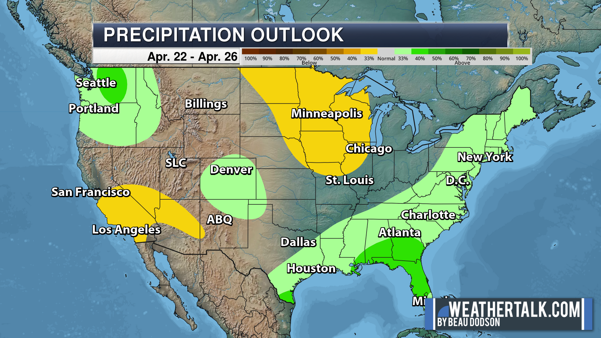
Six to Ten Day Outlook.
Blue is below average. Red is above average. The no color zone represents equal chances.
Average highs for this time of the year are in the lower 60s. Average lows for this time of the year are in the lower 40s.
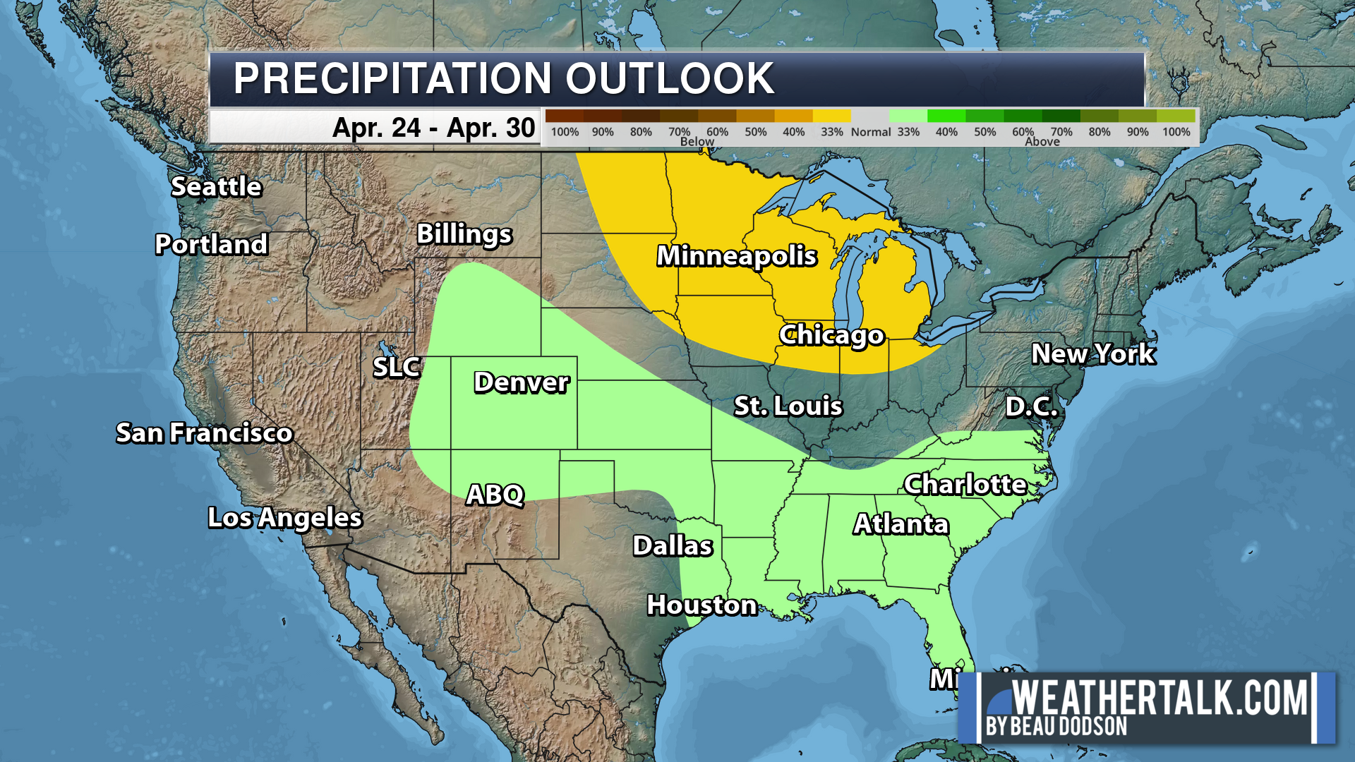
Green is above average precipitation. Yellow and brown favors below average precipitation. Average precipitation for this time of the year is around one inch per week.
.

Average low temperatures for this time of the year are around 50 degrees.
Average precipitation during this time period ranges from 1.00″ to 1.40″
.
.
![]()
The app is for subscribers. Subscribe at www.weathertalk.com/welcome then go to your app store and search for WeatherTalk
Subscribers, PLEASE USE THE APP. ATT and Verizon are not reliable during severe weather. They are delaying text messages.
The app is under WeatherTalk in the app store.
Apple users click here
Android users click here
.

Radars and Lightning Data
Interactive-city-view radars. Clickable watches and warnings.
https://wtalk.co/B3XHASFZ
If the radar is not updating then try another one. If a radar does not appear to be refreshing then hit Ctrl F5. You may also try restarting your browser.
Backup radar site in case the above one is not working.
https://weathertalk.com/morani
Regional Radar
https://imagery.weathertalk.com/prx/RadarLoop.mp4
** NEW ** Zoom radar with chaser tracking abilities!
ZoomRadar
Lightning Data (zoom in and out of your local area)
https://wtalk.co/WJ3SN5UZ
Not working? Email me at beaudodson@usawx.com
National map of weather watches and warnings. Click here.
Storm Prediction Center. Click here.
Weather Prediction Center. Click here.
.

Live lightning data: Click here.
Real time lightning data (another one) https://map.blitzortung.org/#5.02/37.95/-86.99
Our new Zoom radar with storm chases
.
.

Interactive GOES R satellite. Track clouds. Click here.
GOES 16 slider tool. Click here.
College of DuPage satellites. Click here
.

Here are the latest local river stage forecast numbers Click Here.
Here are the latest lake stage forecast numbers for Kentucky Lake and Lake Barkley Click Here.
.
.
Find Beau on Facebook! Click the banner.







 .
.