
Click one of the links below to take you directly to that section
Do you have any suggestions or comments? Email me at beaudodson@usawx.com
.
.
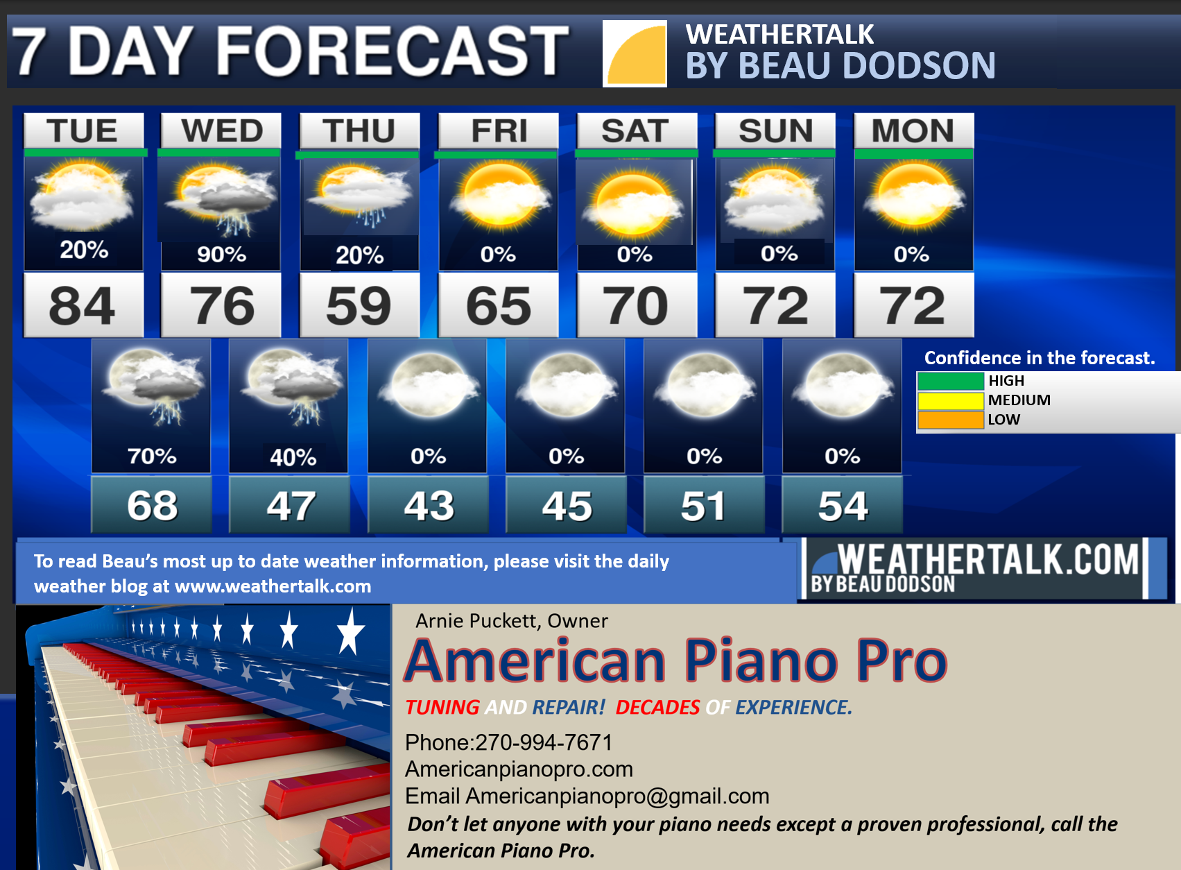
Seven-day forecast for southeast Missouri, southern Illinois, western Kentucky, and western Tennessee.
This is a BLEND for the region. Scroll down to see the region by region forecast.
THE FORECAST IS GOING TO VARY FROM LOCATION TO LOCATION. Scroll down to see the region by region forecast.
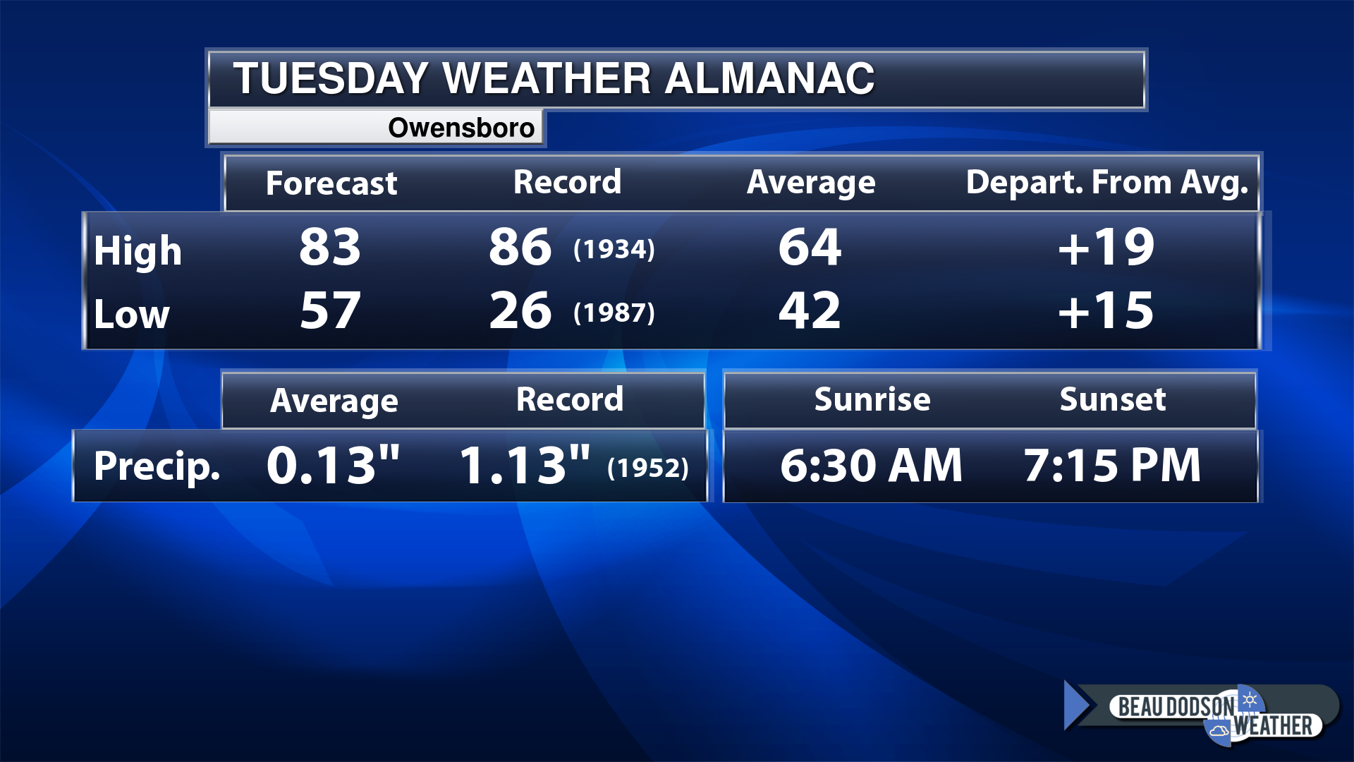
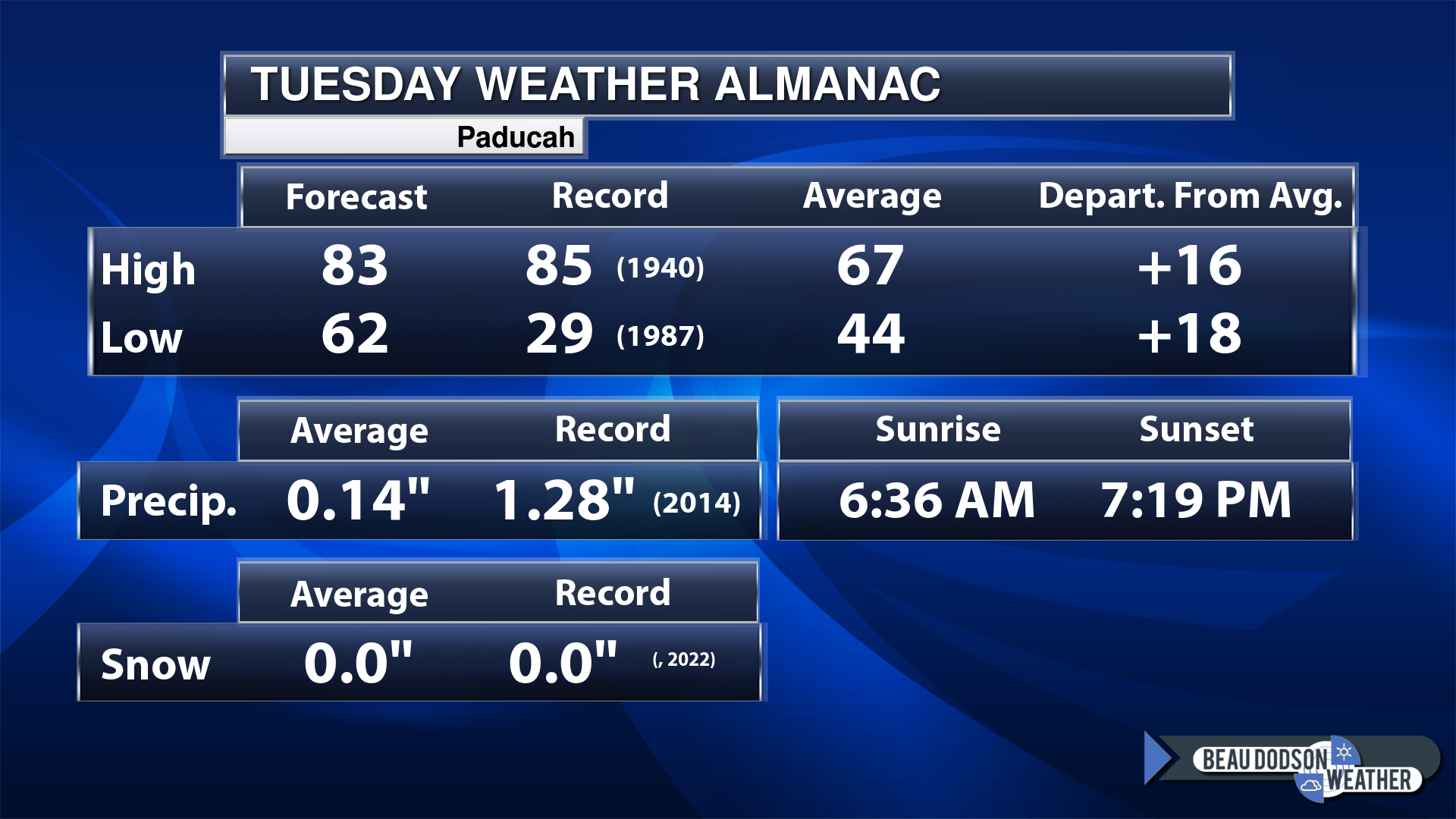
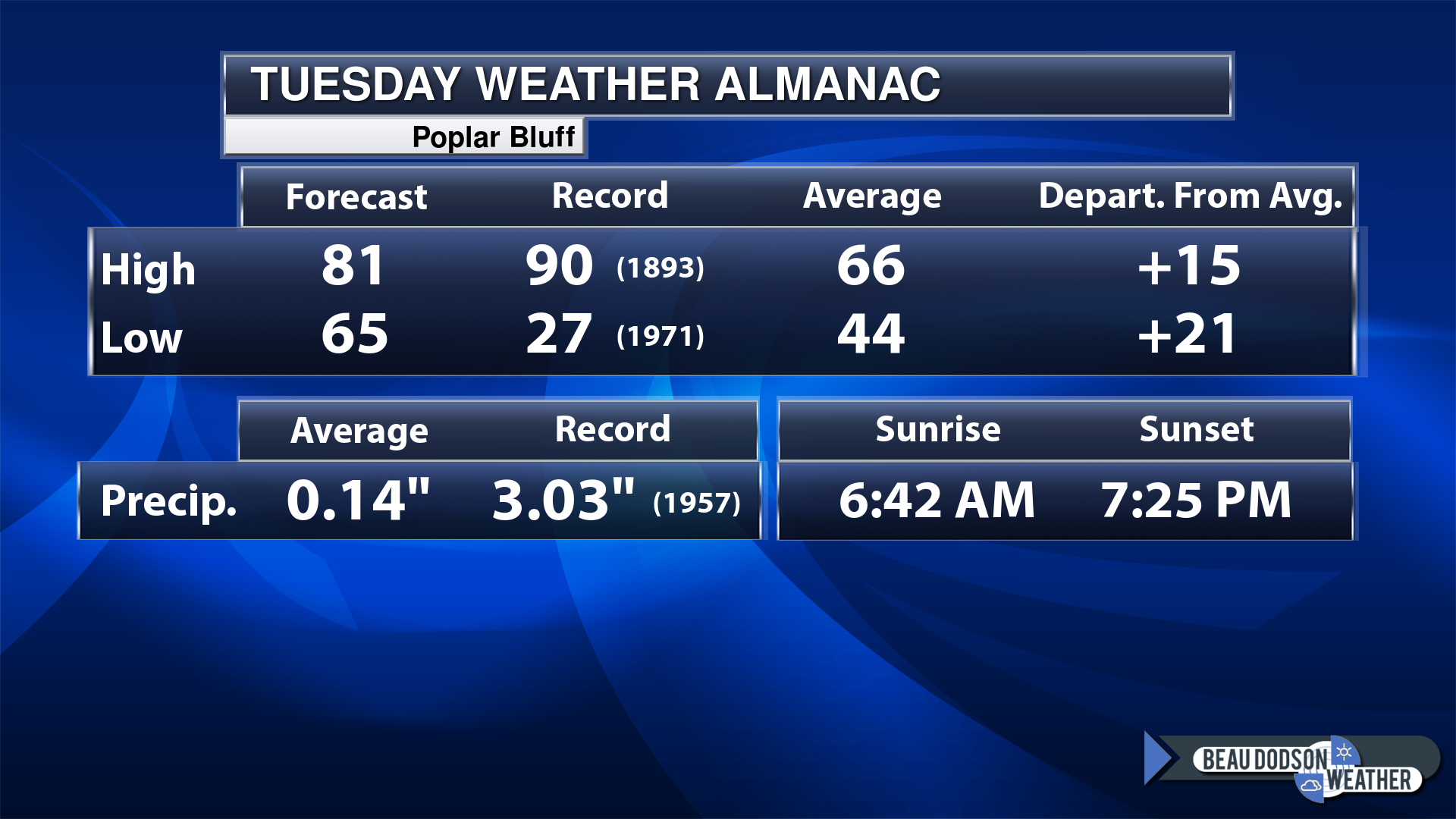
Today’s Local Almanacs (for a few select cities). Your location will be comparable.
Note, the low is this morning’s low and not tomorrows.
This shows you the forecast high. The records. The average and then the departure (how many degrees above or below average will temperatures be).
The graphic shows you what our average daily rainfall is for the day. That is not what is expected (that is the average from past years).
If you have not subscribed to my YouTube Channel then click on this link and it will take you to my videos.
Click the button below and it will take you to the Beau Dodson YouTube Channel.
48-hour forecast


.

.
Tuesday to Tuesday
1. Is lightning in the forecast? Yes. Lightning is likely Tuesday night into Wednesday night.
2. Are severe thunderstorms in the forecast? Yes. Some storms could become severe tonight into Wednesday afternoon/evening. The threat has slowed down some. It now appears the greatest risk will be after midnight tonight into Wednesday afternoon. Several rounds of thunderstorms will be possible with this frontal boundary.
3. Is flash flooding in the forecast? Possible. The system has slowed some and that has increased rain totals. The primary concern will be over western Kentucky and southern Illinois. Any training of thunderstorms could produce excessive rainfall totals and lead to some flooding. Mainly commonly flooded areas.
4. Will the wind chill dip below 10 degrees? No.
5. Is measurable snow and/or sleet in the forecast? No.
6. Is freezing rain/ice in the forecast? No.
Freezing rain is rain that falls and instantly freezes on objects such as trees and power lines
6. Will the heat index exceed 100 degrees? No.
.
Tuesday, April 4, 2023
Confidence in the forecast? High Confidence
Tuesday Forecast: Partly sunny. A chance of showers and thunderstorms. Most areas will remain dry today.
What is the chance of precipitation?
Far northern southeast Missouri ~ 20%
Southeast Missouri ~ 20%
The Missouri Bootheel ~ 20%
I-64 Corridor of southern Illinois ~ 30%
Southern Illinois ~ 20%
Extreme southern Illinois (southern seven counties) ~ 20%
Far western Kentucky ~ 20%
The Pennyrile area of western KY ~ 20%
Northwest Kentucky (near Indiana border) ~ 20%
Northwest Tennessee ~ 20%
Coverage of precipitation: Isolated
Timing of the precipitation: Any given point of time
Temperature range:
Far northern southeast Missouri ~ 80° to 84°
Southeast Missouri ~ 80° to 84°
The Missouri Bootheel ~ 80° to 84°
I-64 Corridor of southern Illinois ~ 80° to 84°
Southern Illinois ~ 80° to 84°
Extreme southern Illinois (southern seven counties) ~ 80° to 84°
Far western Kentucky ~ 80° to 84°
The Pennyrile area of western KY ~ 80° to 84°
Northwest Kentucky (near Indiana border) ~ 80° to 84°
Northwest Tennessee ~ 80° to 84°
Winds will be from this direction: South 10 to 20 mph. Gusty.
Wind chill or heat index (feels like) temperature forecast: 80° to 84°
What impacts are anticipated from the weather? Wet roadways. Lightning.
Should I cancel my outdoor plans? No, but check the Beau Dodson Weather Radars.
UV Index: 7. High
Sunrise: 6:37 AM
Sunset: 7:20 PM
.
Tuesday night Forecast: Partly cloudy. Mild. A chance of showers and thunderstorms. Mainly late at night.
What is the chance of precipitation?
Far northern southeast Missouri ~ 70%
Southeast Missouri ~ 70%
The Missouri Bootheel ~ 70%
I-64 Corridor of southern Illinois ~ 70%
Southern Illinois ~ 70%
Extreme southern Illinois (southern seven counties) ~ 70%
Far western Kentucky ~ 70%
The Pennyrile area of western KY ~ 60%
Northwest Kentucky (near Indiana border) ~ 60%
Northwest Tennessee ~ 60%
Coverage of precipitation: Scattered to numerous
Timing of the precipitation: Any given point of time
Temperature range:
Far northern southeast Missouri ~ 62° to 65°
Southeast Missouri ~ 62° to 65°
The Missouri Bootheel ~ 62° to 65°
I-64 Corridor of southern Illinois ~ 62° to 65°
Southern Illinois ~ 62° to 65°
Extreme southern Illinois (southern seven counties) ~ 62° to 65°
Far western Kentucky ~ 62° to 65°
The Pennyrile area of western KY ~ 62° to 65°
Northwest Kentucky (near Indiana border) ~ 62° to 65°
Northwest Tennessee ~ 62° to 65°
Winds will be from this direction: South 10 to 25 mph
Wind chill or heat index (feels like) temperature forecast: 60° to 65°
What impacts are anticipated from the weather? Wet roadways. Lightning. Some storms could be intense.
Should I cancel my outdoor plans? No, but check the Beau Dodson Weather Radars
Moonrise: 6:04 PM
Moonset: 6:06 AM
The phase of the moon: Waning Gibbous
.
Wednesday, April 5, 2023
Confidence in the forecast? High Confidence
Wednesday Forecast: Partly sunny. A chance of showers and thunderstorms.
What is the chance of precipitation?
Far northern southeast Missouri ~ 80%
Southeast Missouri ~ 80%
The Missouri Bootheel ~ 90%
I-64 Corridor of southern Illinois ~ 80%
Southern Illinois ~ 80%
Extreme southern Illinois (southern seven counties) ~ 90%
Far western Kentucky ~ 90%
The Pennyrile area of western KY ~ 70%
Northwest Kentucky (near Indiana border) ~ 80%
Northwest Tennessee ~ 80%
Coverage of precipitation: Numerous
Timing of the precipitation: Any given point of time
Temperature range:
Far northern southeast Missouri ~ 70° to 75°
Southeast Missouri ~ 70° to 75°
The Missouri Bootheel ~ 70° to 75°
I-64 Corridor of southern Illinois ~ 70° to 75°
Southern Illinois ~ 70° to 75°
Extreme southern Illinois (southern seven counties) ~ 70° to 75°
Far western Kentucky ~ 70° to 75°
The Pennyrile area of western KY ~ 70° to 75°
Northwest Kentucky (near Indiana border) ~ 70° to 75°
Northwest Tennessee ~ 70° to 75°
Winds will be from this direction: Southwest 10 to 20 mph. Gusty.
Wind chill or heat index (feels like) temperature forecast: 70° to 75°
What impacts are anticipated from the weather? Wet roadways. Lightning. Monitor the risk of heavy storms.
Should I cancel my outdoor plans? No, but check the Beau Dodson Weather Radars.
UV Index: 7. High
Sunrise: 6:35 AM
Sunset: 7:21 PM
.
Wednesday night Forecast: Partly cloudy. Mild. A chance of showers and thunderstorms.
What is the chance of precipitation?
Far northern southeast Missouri ~ 30%
Southeast Missouri ~ 30%
The Missouri Bootheel ~ 30%
I-64 Corridor of southern Illinois ~ 30%
Southern Illinois ~ 40%
Extreme southern Illinois (southern seven counties) ~ 40%
Far western Kentucky ~ 40%
The Pennyrile area of western KY ~ 60%
Northwest Kentucky (near Indiana border) ~ 60%
Northwest Tennessee ~ 40%
Coverage of precipitation: Scattered west with more numerous the farther east you travel
Timing of the precipitation: Before midnight
Temperature range:
Far northern southeast Missouri ~ 38° to 42°
Southeast Missouri ~ 40° to 42°
The Missouri Bootheel ~ 42° to 45°
I-64 Corridor of southern Illinois ~ 38° to 42°
Southern Illinois ~ 40° to 44°
Extreme southern Illinois (southern seven counties) ~ 42° to 45°
Far western Kentucky ~ 42° to 45°
The Pennyrile area of western KY ~ 42° to 45°
Northwest Kentucky (near Indiana border) ~ 42° to 45°
Northwest Tennessee ~ 42° to 45°
Winds will be from this direction: West northwest 10 to 20 mph. Gusty.
Wind chill or heat index (feels like) temperature forecast: 35° to 40°
What impacts are anticipated from the weather? Wet roadways. Lightning.
Should I cancel my outdoor plans? No, but check the Beau Dodson Weather Radars
Moonrise: 7:04 PM
Moonset: 6:29 AM
The phase of the moon: Full
.
Thursday, April 6, 2023
Confidence in the forecast? High Confidence
Thursday Forecast: Partly cloudy. A chance of a few remaining showers and thunderstorms over our eastern counties.
What is the chance of precipitation?
Far northern southeast Missouri ~ 10%
Southeast Missouri ~ 10%
The Missouri Bootheel ~ 10%
I-64 Corridor of southern Illinois ~ 20%
Southern Illinois ~ 20%
Extreme southern Illinois (southern seven counties) ~ 20%
Far western Kentucky ~ 30%
The Pennyrile area of western KY ~ 30%
Northwest Kentucky (near Indiana border) ~ 30%
Northwest Tennessee ~ 20%
Coverage of precipitation: Widely scattered
Timing of the precipitation: Mainly before noon
Temperature range:
Far northern southeast Missouri ~ 58° to 60°
Southeast Missouri ~ 58° to 60°
The Missouri Bootheel ~ 58° to 60°
I-64 Corridor of southern Illinois ~ 58° to 60°
Southern Illinois ~ 58° to 60°
Extreme southern Illinois (southern seven counties) ~ 58° to 60°
Far western Kentucky ~ 58° to 60°
The Pennyrile area of western KY ~ 58° to 60°
Northwest Kentucky (near Indiana border) ~ 58° to 60°
Northwest Tennessee ~ 58° to 60°
Winds will be from this direction: North northwest 10 to 20 mph
Wind chill or heat index (feels like) temperature forecast: 58° to 60°
What impacts are anticipated from the weather? Wet roadways. Lightning.
Should I cancel my outdoor plans? No, but check the Beau Dodson Weather Radars.
UV Index: 4. Moderate
Sunrise: 6:34 AM
Sunset: 7:22 PM
.
Thursday night Forecast: Partly cloudy.
What is the chance of precipitation?
Far northern southeast Missouri ~ 0%
Southeast Missouri ~ 0%
The Missouri Bootheel ~ 0%
I-64 Corridor of southern Illinois ~ 0%
Southern Illinois ~ 0%
Extreme southern Illinois (southern seven counties) ~ 0%
Far western Kentucky ~ 0%
The Pennyrile area of western KY ~ 0%
Northwest Kentucky (near Indiana border) ~ 0%
Northwest Tennessee ~ 0%
Coverage of precipitation:
Timing of the precipitation:
Temperature range:
Far northern southeast Missouri ~ 34° to 38°
Southeast Missouri ~ 35° to 40°
The Missouri Bootheel ~ 35° to 40°
I-64 Corridor of southern Illinois ~ 35° to 40°
Southern Illinois ~ 35° to 40°
Extreme southern Illinois (southern seven counties) ~ 35° to 40°
Far western Kentucky ~ 35° to 40°
The Pennyrile area of western KY ~ 35° to 40°
Northwest Kentucky (near Indiana border) ~ 35° to 40°
Northwest Tennessee ~ 35° to 40°
Winds will be from this direction: Northeast 7 to 14 mph
Wind chill or heat index (feels like) temperature forecast: 32° to 38°
What impacts are anticipated from the weather?
Should I cancel my outdoor plans? No
Moonrise: 8:08 PM
Moonset: 6:52 AM
The phase of the moon: Full
Click here if you would like to return to the top of the page.
-
- Warm today. Windy. A slight chance of thunderstorms. The cold front has slowed.
- Thunderstorm chances increasing tonight into Wednesday night.
- Monitoring the risk of a few severe storms.
Weather advice:
As we prepare for spring, let’s make sure you have three to five ways of receiving your severe weather information.
.
Forecast Discussion
The frontal boundary, that I have been talking about for several days now, has slowed. It has slowed considerably.
What appeared to be an event that would happen today and tonight, is now more likely to occur tonight into Wednesday night.
The front has slowed by eight to fourteen hours.
This slowing process has caused some adjustments to the overall forecast.
For one, I have decreased shower and thunderstorm chances today/this afternoon. Only an isolated chance exists. For the most part, today will be very warm and dry. Windy, as well.
Temperatures will rise into the 80s over most of the region with near record high temperatures possible in some locations. A warm and windy day!
Winds will gust above 20 mph from the south.
These southerly winds will continue to pump moisture into the region. This will set the stage for the development of thunderstorms along an incoming cold front.
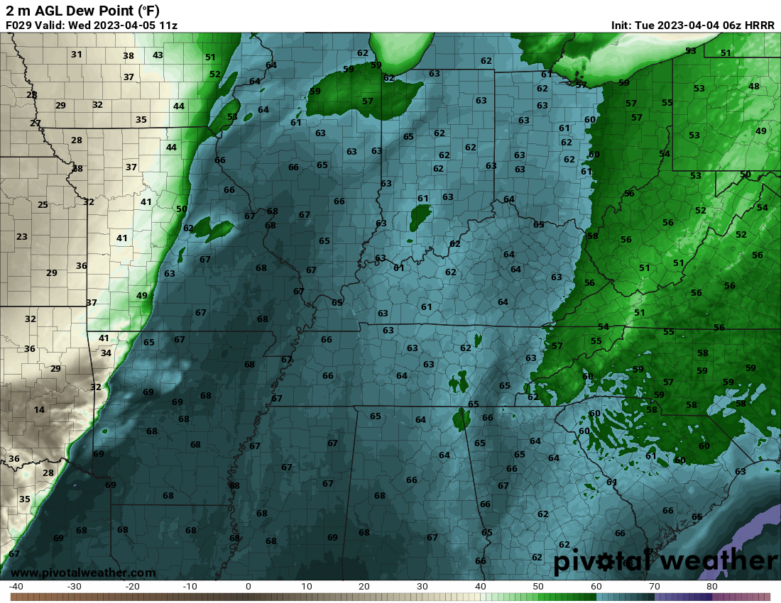
Dew points, a measure of moisture, will rise well into the sixties today and tonight into tomorrow. That is a lot of moisture for thunderstorms to tap into.
You can see that wide warm sector on this graphic showing you the dew points.
The cold front will remain to our west through most of tonight.
It will begin to nudge into southeast Missouri tomorrow morning.
A few thunderstorms may form well ahead of the cold front, but this remains uncertain. If thunderstorms to form ahead of the cold front they could be multi-cells or supercells. Those type of storms can become severe.
More likely, will be a line of thunderstorms along and near the cold front. The line of storms could also become severe with damaging wind being the primary concern. There will also be a threat of a few hail reports.
The tornado risk will lower with time, but early on there could be some tornadoes, as well.
We will need to monitor a lot of moving parts with this overall forecast.
There remain questions about the exact timing of shower and thunderstorm development. If the storms form earlier than expected then there will be quite a bit of energy for them to tap into. A lot of spin in the atmosphere, as well.
The peak of the unstable air will be this afternoon into the first half of tonight. After that, CAPE and other parameters will begin to diminish some.
The bottom line is that you should monitor weather updates into Wednesday afternoon and evening.
Some of the showers and thunderstorms may linger into Thursday morning, as well. That would primarily be over western Kentucky. The rest of the region will be drying out.
Rain totals will vary greatly based on the placement of thunderstorms. I suspect some counties will top an inch of rain. Especially where thunderstorms repeatedly train over the same areas.
I can’t rule out some brief flooding issues if thunderstorms train repeatedly.
The risk of training showers and thunderstorms is a bit higher from western Tennessee into western Kentucky.
Dry conditions are anticipated Thursday afternoon through Monday.
A weak system attempts to pop a shower or two Monday or Monday night. For now, this does not appear to be a big deal.
It will be somewhat cooler behind our cold front Thursday compared to today and tomorrow.
.
Click here if you would like to return to the top of the page.
This outlook covers southeast Missouri, southern Illinois, western Kentucky, and far northwest Tennessee.
Today through March 31st: I am closely monitoring a storm system that is forecast to arrive Friday. A cold front will move across the region. This front will have strong wind shear and moisture to work with. Severe thunderstorms are possible/likely in the region. This event is still several days away, but data does indicate the potential of damaging wind, hail, and even a tornado. Monitor updates.
The primary time-frame of concern will be Friday afternoon and evening.
.
Today’s Storm Prediction Center’s Severe Weather Outlook
Light green is where thunderstorms may occur but should be below severe levels.
Dark green is a level one risk. Yellow is a level two risk. Orange is a level three (enhanced) risk. Red is a level four (moderate) risk. Pink is a level five (high) risk.
One is the lowest risk. Five is the highest risk.
A severe storm is one that produces 58 mph wind or higher, quarter size hail, and/or a tornado.
Explanation of tables. Click here.

.
Tornado Probability Outlook

.
Large Hail Probability Outlook

.
High wind Probability Outlook

.
Tomorrow’s severe weather outlook.

.
Day Three Severe Weather Outlook

.

.
The images below are from NOAA’s Weather Prediction Center.
24-hour precipitation outlook..
 .
.
.
48-hour precipitation outlook.
. .
.
![]()
_______________________________________
.

Click here if you would like to return to the top of the page.
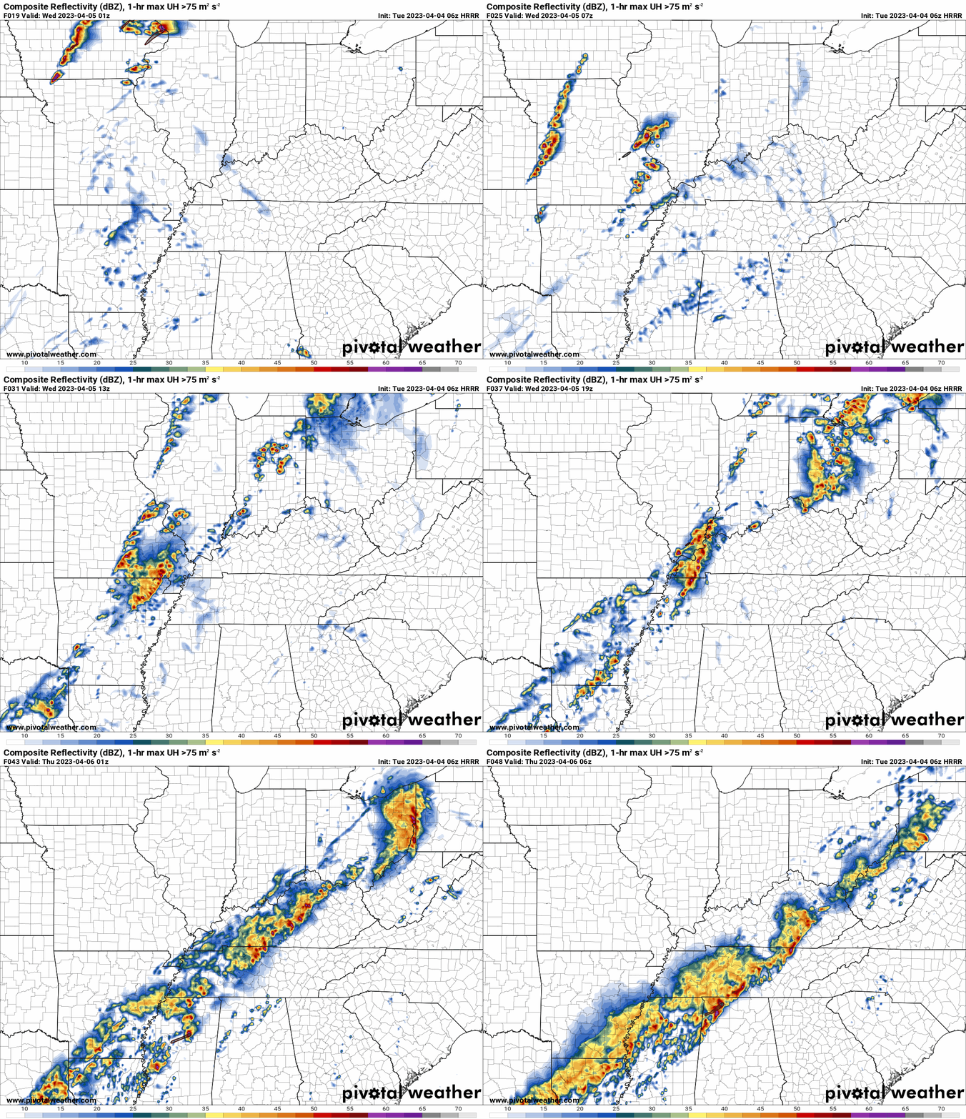
Again, as a reminder, these are models. They are never 100% accurate. Take the general idea from them.
What should I take from these?
- The general idea and not specifics. Models usually do well with the generalities.
- The time-stamp is located in the upper left corner.
.
What am I looking at?
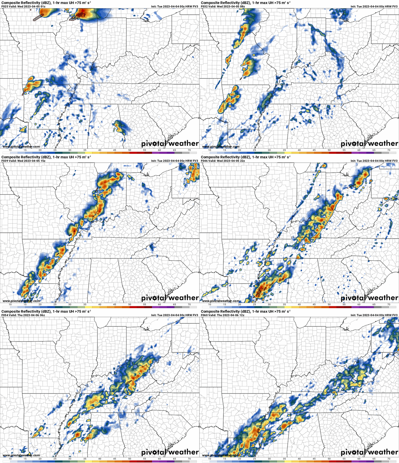
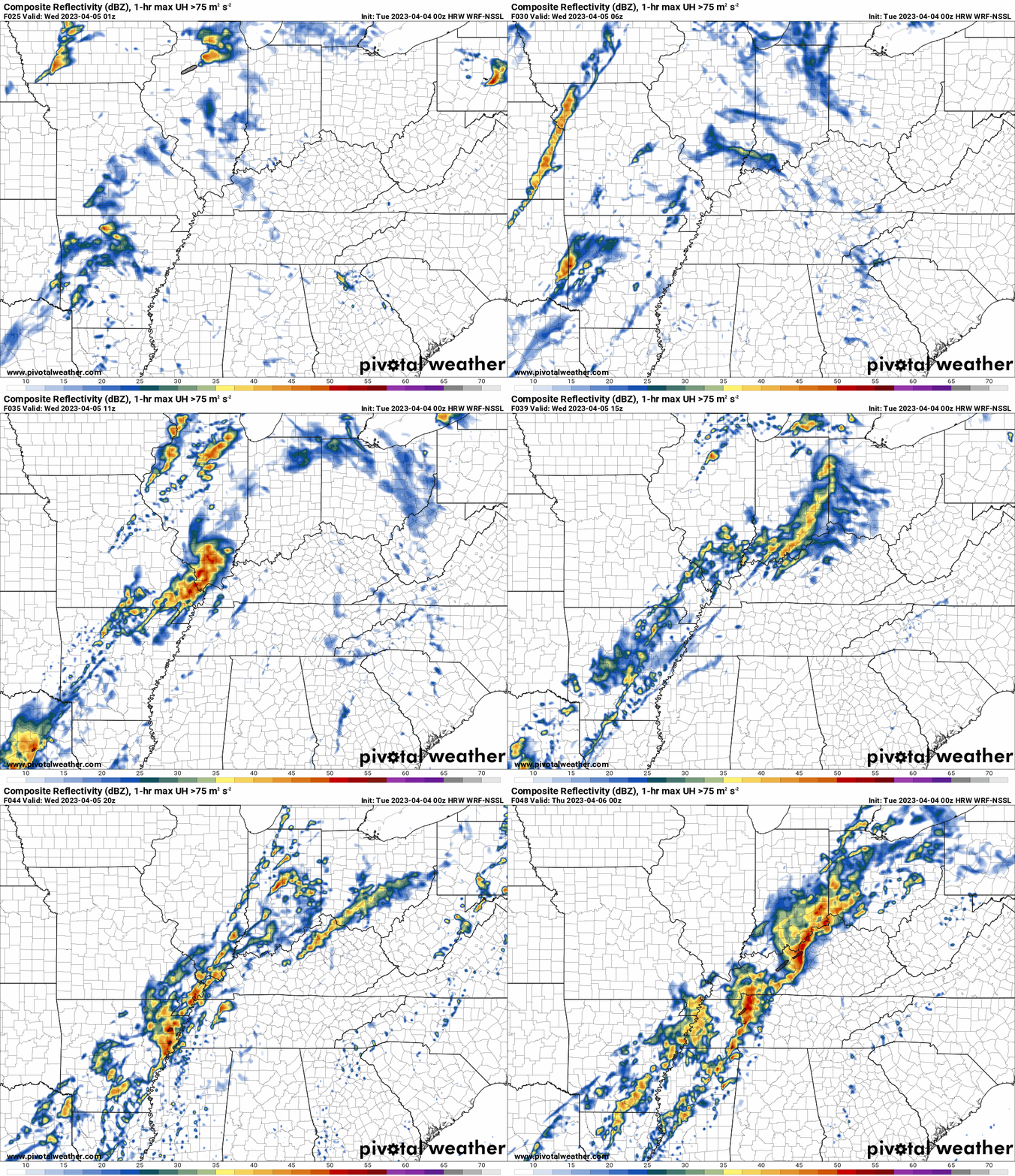
You are looking at computer model data. Meteorologists use many different models to forecast the weather.
Occasionally, these maps are in Zulu time. 12z=7 AM. 18z=1 PM. 00z=7 PM. 06z=1 AM
Green represents light rain. Dark green represents moderate rain. Yellow and orange represent heavier rain.
This animation is the FVS Model.
This animation is the NSSL Model.
This animation is the Hrrr Model.
.
..![]()

.
Click here if you would like to return to the top of the page.
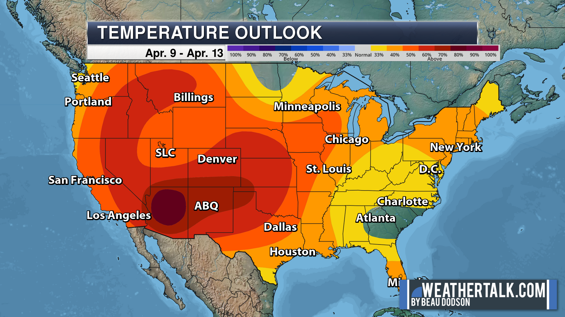
.Average high temperatures for this time of the year are around 60 degrees.
Average low temperatures for this time of the year are around 40 degrees.
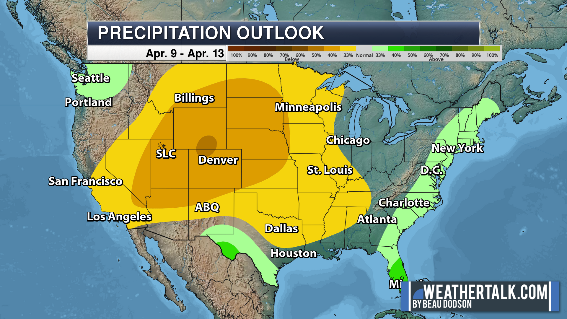
Average precipitation during this time period ranges from 0.80″ to 1.00″
Six to Ten Day Outlook.
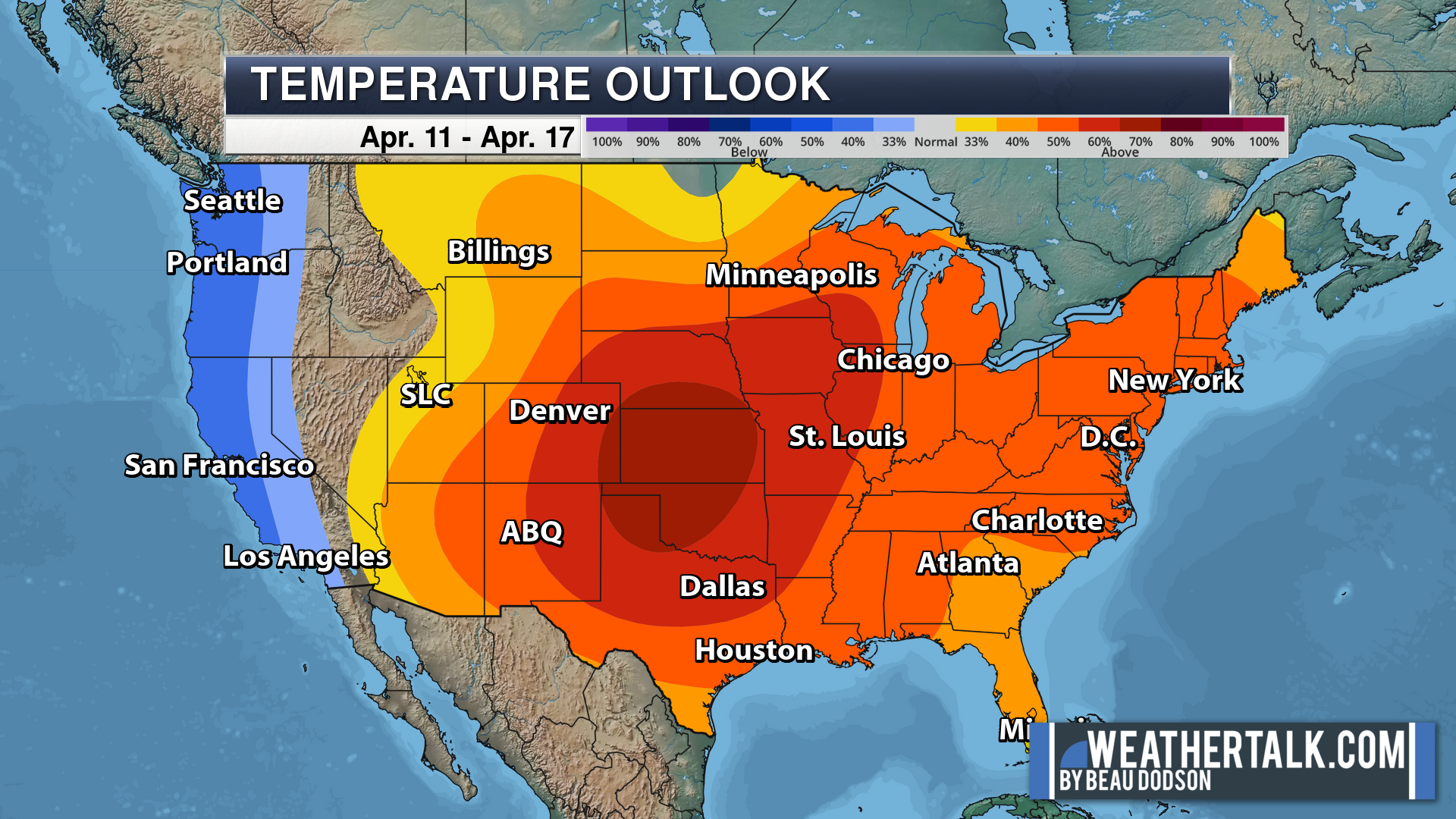
Blue is below average. Red is above average. The no color zone represents equal chances.
Average highs for this time of the year are in the lower 60s. Average lows for this time of the year are in the lower 40s.
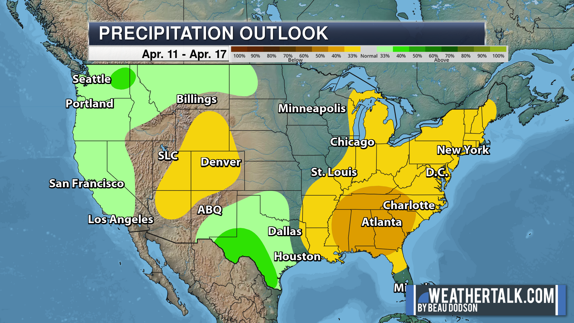
Green is above average precipitation. Yellow and brown favors below average precipitation. Average precipitation for this time of the year is around one inch per week.
.

Average low temperatures for this time of the year are around 42 degrees.
Average precipitation during this time period ranges from 0.80″ to 1.00″
.
.
![]()
The app is for subscribers. Subscribe at www.weathertalk.com/welcome then go to your app store and search for WeatherTalk
Subscribers, PLEASE USE THE APP. ATT and Verizon are not reliable during severe weather. They are delaying text messages.
The app is under WeatherTalk in the app store.
Apple users click here
Android users click here
.

Radars and Lightning Data
Interactive-city-view radars. Clickable watches and warnings.
https://wtalk.co/B3XHASFZ
If the radar is not updating then try another one. If a radar does not appear to be refreshing then hit Ctrl F5. You may also try restarting your browser.
Backup radar site in case the above one is not working.
https://weathertalk.com/morani
Regional Radar
https://imagery.weathertalk.com/prx/RadarLoop.mp4
** NEW ** Zoom radar with chaser tracking abilities!
ZoomRadar
Lightning Data (zoom in and out of your local area)
https://wtalk.co/WJ3SN5UZ
Not working? Email me at beaudodson@usawx.com
National map of weather watches and warnings. Click here.
Storm Prediction Center. Click here.
Weather Prediction Center. Click here.
.

Live lightning data: Click here.
Real time lightning data (another one) https://map.blitzortung.org/#5.02/37.95/-86.99
Our new Zoom radar with storm chases
.
.

Interactive GOES R satellite. Track clouds. Click here.
GOES 16 slider tool. Click here.
College of DuPage satellites. Click here
.

Here are the latest local river stage forecast numbers Click Here.
Here are the latest lake stage forecast numbers for Kentucky Lake and Lake Barkley Click Here.
.
.
Find Beau on Facebook! Click the banner.








 .
.