.
SCROLL DOWN THE PAGE FOR THE DISCUSSION UPDATES
.
Click on the words below to subscribe
Storm Tracking Links
Interactive local city-view radars. Clickable watches and warnings.
https://wtalk.co/B3XHASFZ
Backup radar site in case the above one is not working.
https://weathertalk.com/morani
Regional Radar
https://imagery.weathertalk.com/prx/RadarLoop.mp4
*NEW* Zoom interactive radar (with storm chaser streams)
https://wtalk.co/AVWG7GM7
Real time lightning tracker system two.
https://map.blitzortung.org/#5.02/37.95/-86.99
Lightning Data (zoom in and out of your local area)
https://wtalk.co/WJ3SN5UZ
The app is for www.weathertalk.com subscribers. Subscriber first and then download the app.
Apple users click here. Android users click here.
What you need to know
Key Points
- Severe thunderstorms are possible later today and this afternoon. Damaging wind is the primary concern. A tornado can not be ruled out.
- Have your Beau Dodson Weather app on. Check it. Make sure you have not logged out of the app.
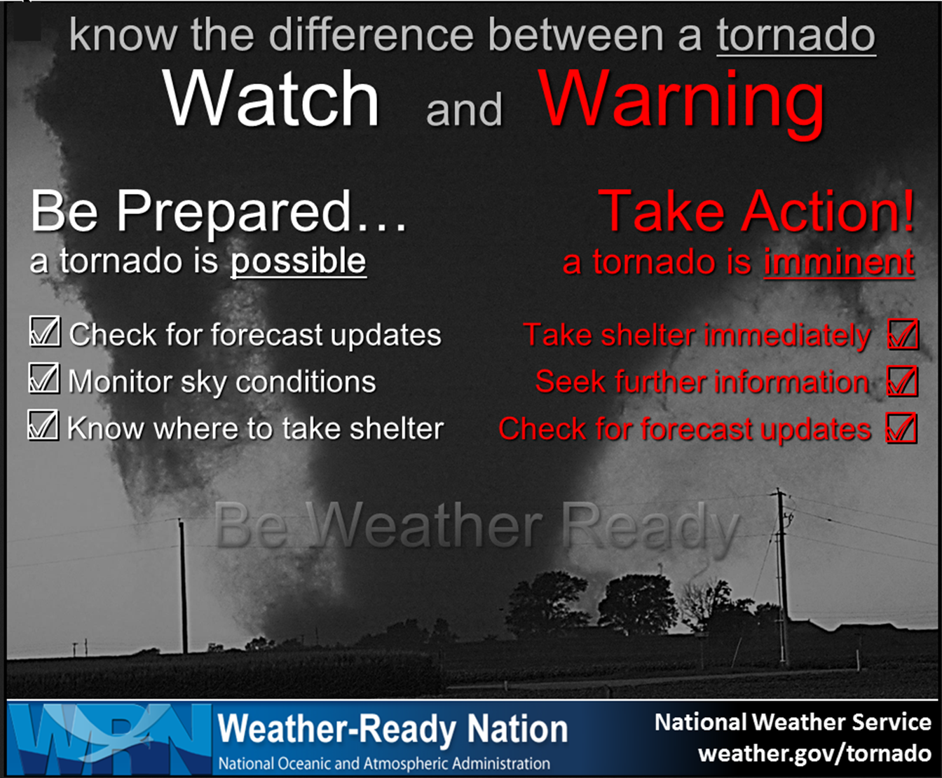
- Remember, a watch means to monitor updates. A warning means to seek shelter. A warning is a higher threat and means to seek shelter immediately. Severe weather may occur in or near your location.
.

Here is Facebooks’ Severe Weather Q&A threads.
Link https://www.facebook.com/beaudodsonweather
.
The latest blog updates will be posted here at the top of Beau’s severe weather blog.
.
3:15 PM
Severe weather risk has ended for all of my counties except a portion of Christian and Todd Counties. It will end there shortly.
.
2 PM
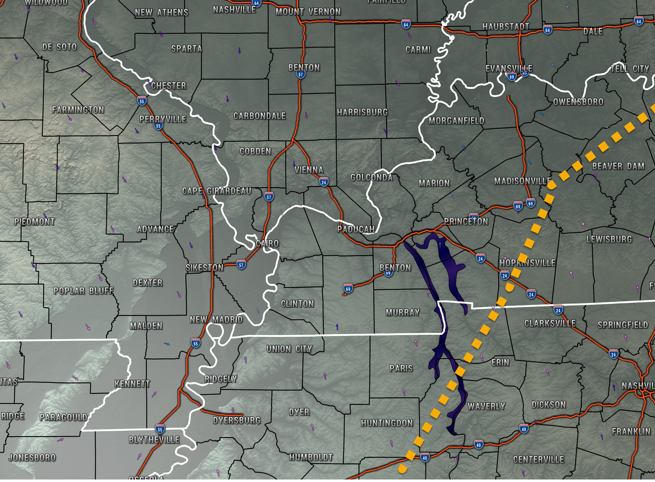
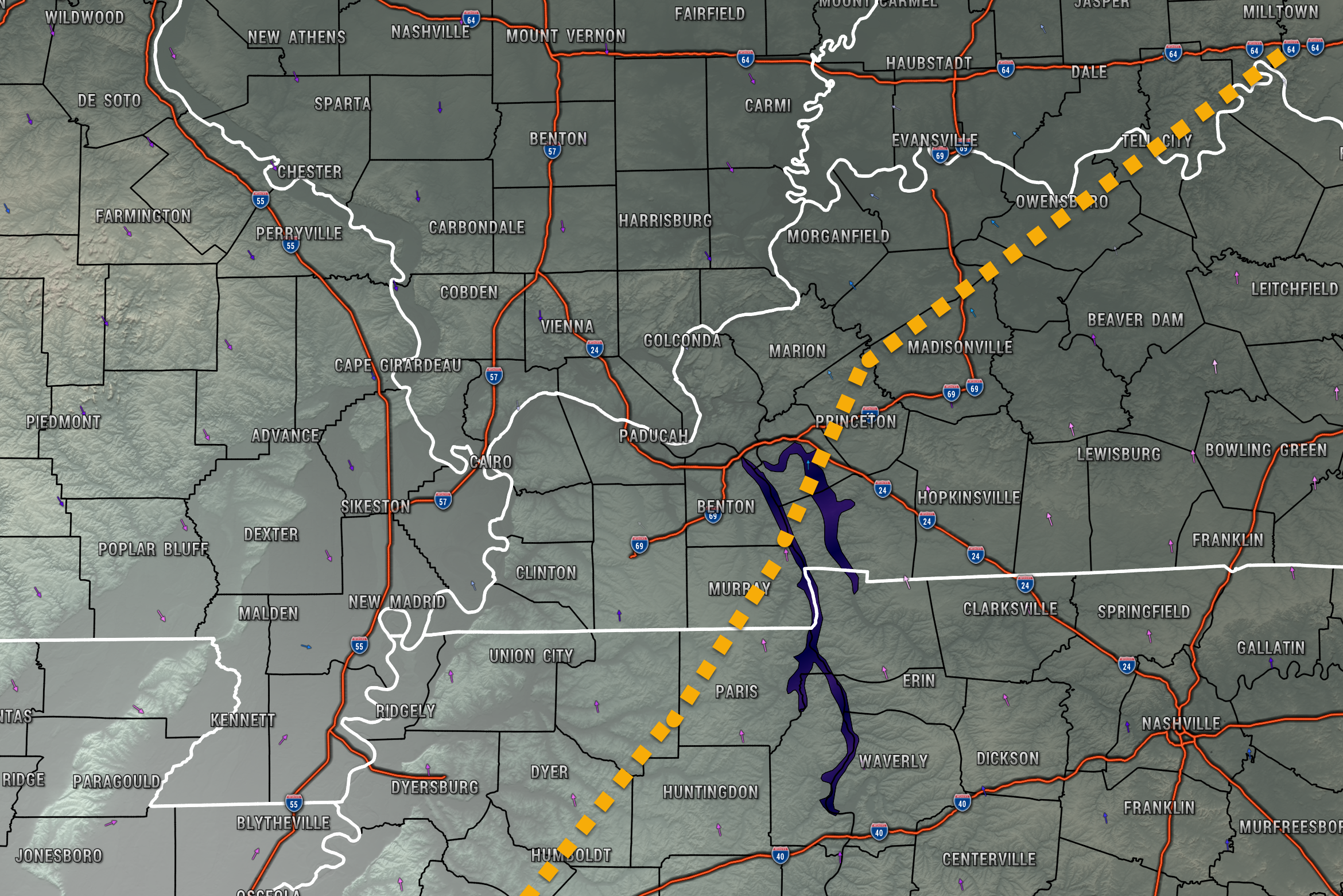
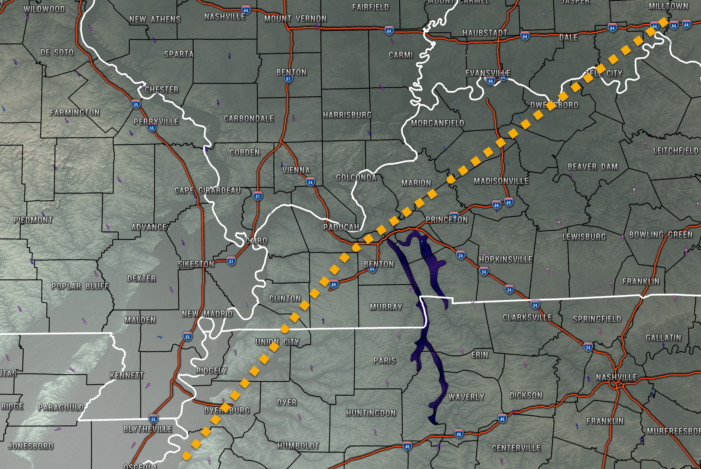
Severe weather risk has ended behind the orange dotted line.
.
1:35 PM
I have no severe weather concerns along and behind (to the left) the orange dotted line. This line will shift eastward as we move through the afternoon.
1:30 PM
.
Without CAPE we won’t have severe storms.
A little CAPE may still form, thus we will continue to monitor the radars.
.
1:25 PM
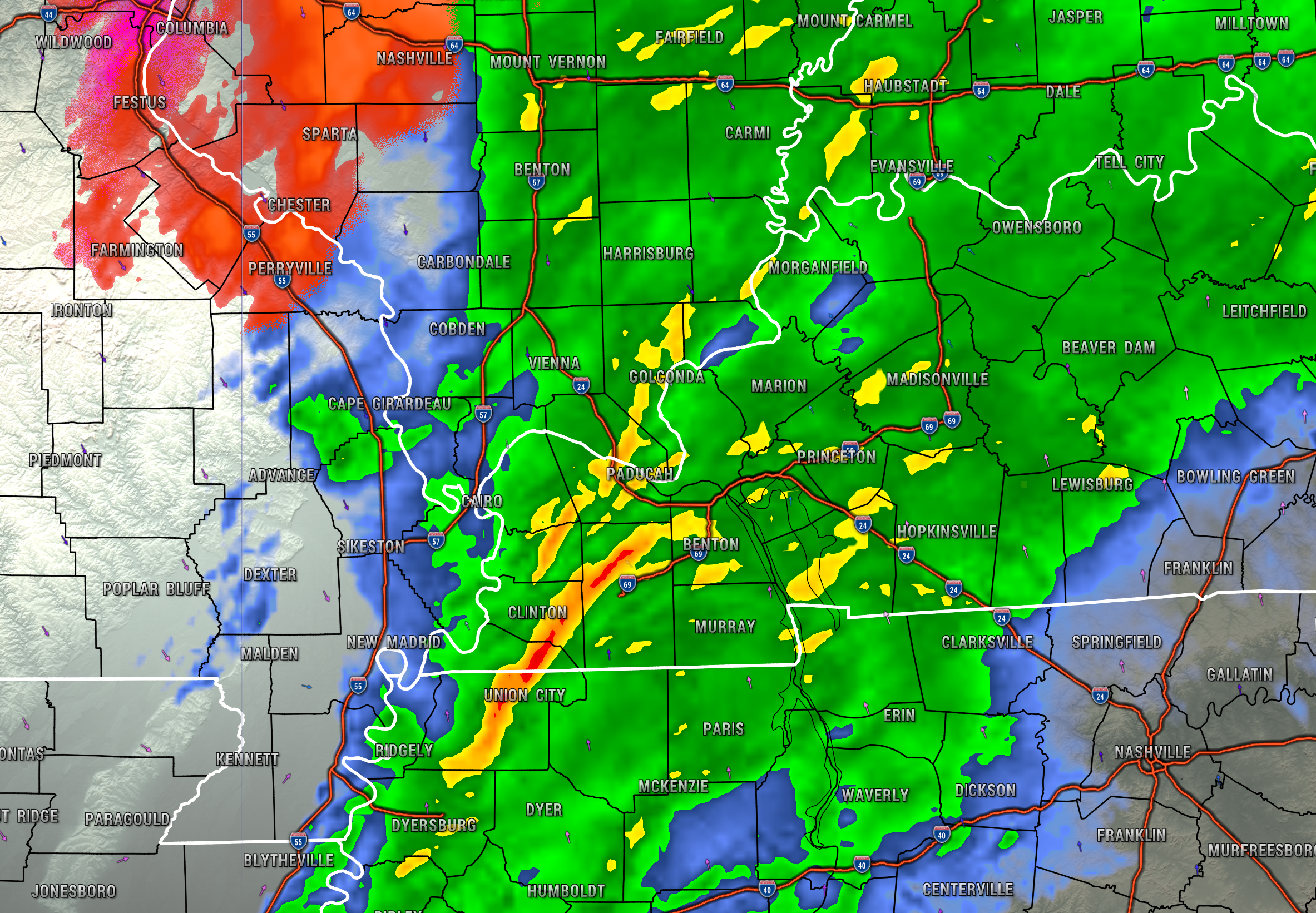
The line of showers and storms in western Kentucky and northwest Tennessee may have strong wind gusts ahead and behind it. It is moving east/northeast.
.
1 PM
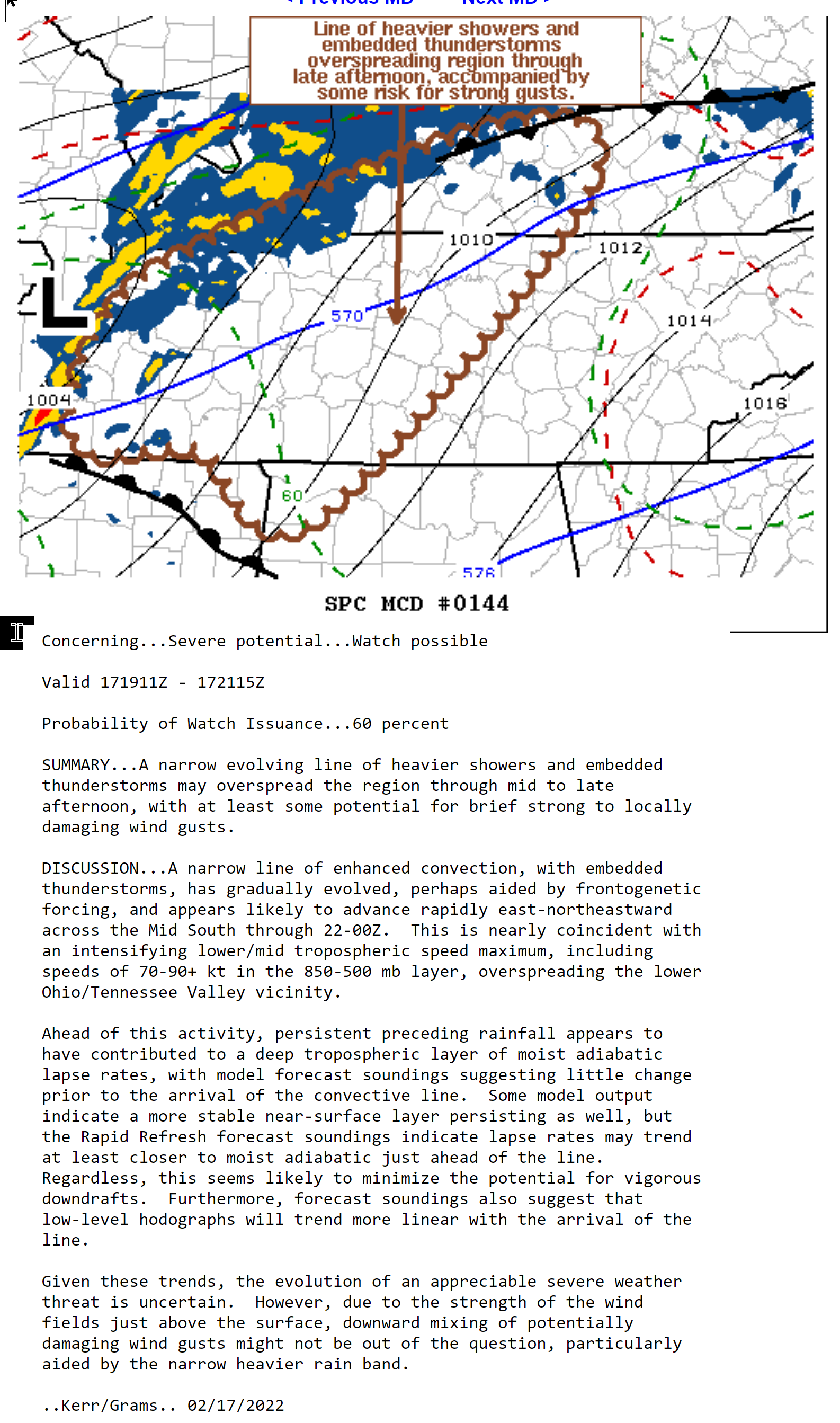
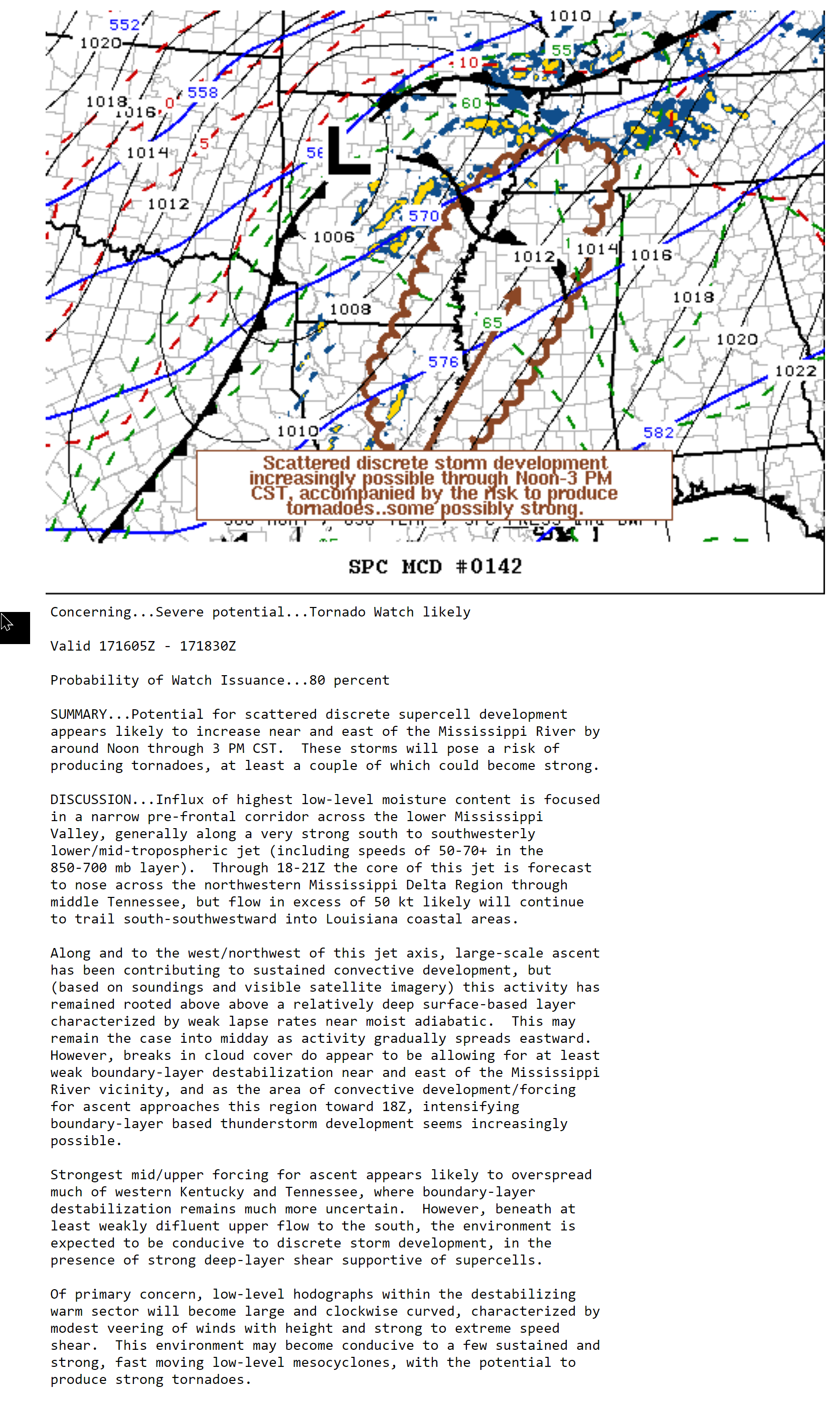
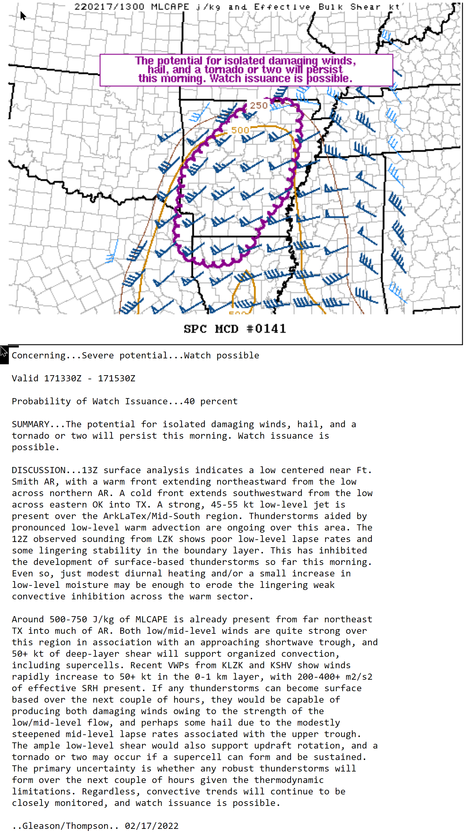
The Storm Prediction is considering a severe weather watch from LBL east/northeast. There is a 60% chance of a watch being issued.
There is not much CAPE to work with. The main concern will be damaging wind gusts.
Technical discussion.
.
12:45 PM
PAH issues Flash Flood Warning for Alexander, Johnson, Massac, Pulaski, Union [IL] till 6:00 PM CST
| PAH issues Flash Flood Warning for Caldwell, Calloway, Christian, Hopkins, Lyon, Muhlenberg, Todd, Trigg [KY] till 6:45 PM CST |
12:40 PM
I have no severe weather concerns for southeast Missouri or southern Illinois.
I am still watching Kentucky and Tennessee.
.
12:15 PM
The area of low pressure is moving into the Bootheel. Severe weather is typically found along the path of the low and to the south of the low.
Right now we have zero CAPE in the area. CAPE is energy that storms tap into. You can not have severe weather without CAPE.
The clouds and rain are helping to keep CAPE from forming. We will have to see how the next few hours go. So far so good as far as severe thunderstorms.
Widespread moderate to heavy rain covers our region. Some areas will exceed four inches of rain. Avoid flooded roadways.
.
12 PM
PAH issues Flash Flood Warning for Alexander, Pulaski [IL] and Ballard, Carlisle, Graves, Marshall, McCracken [KY] till 6:00 PM CST
.
11:45 AM
PAH issues Areal Flood Warning for Gibson, Pike, Posey, Spencer, Vanderburgh, Warrick [IN] and Daviess, Henderson, McLean, Union [KY] till 8:15 PM CST
.
11 AM
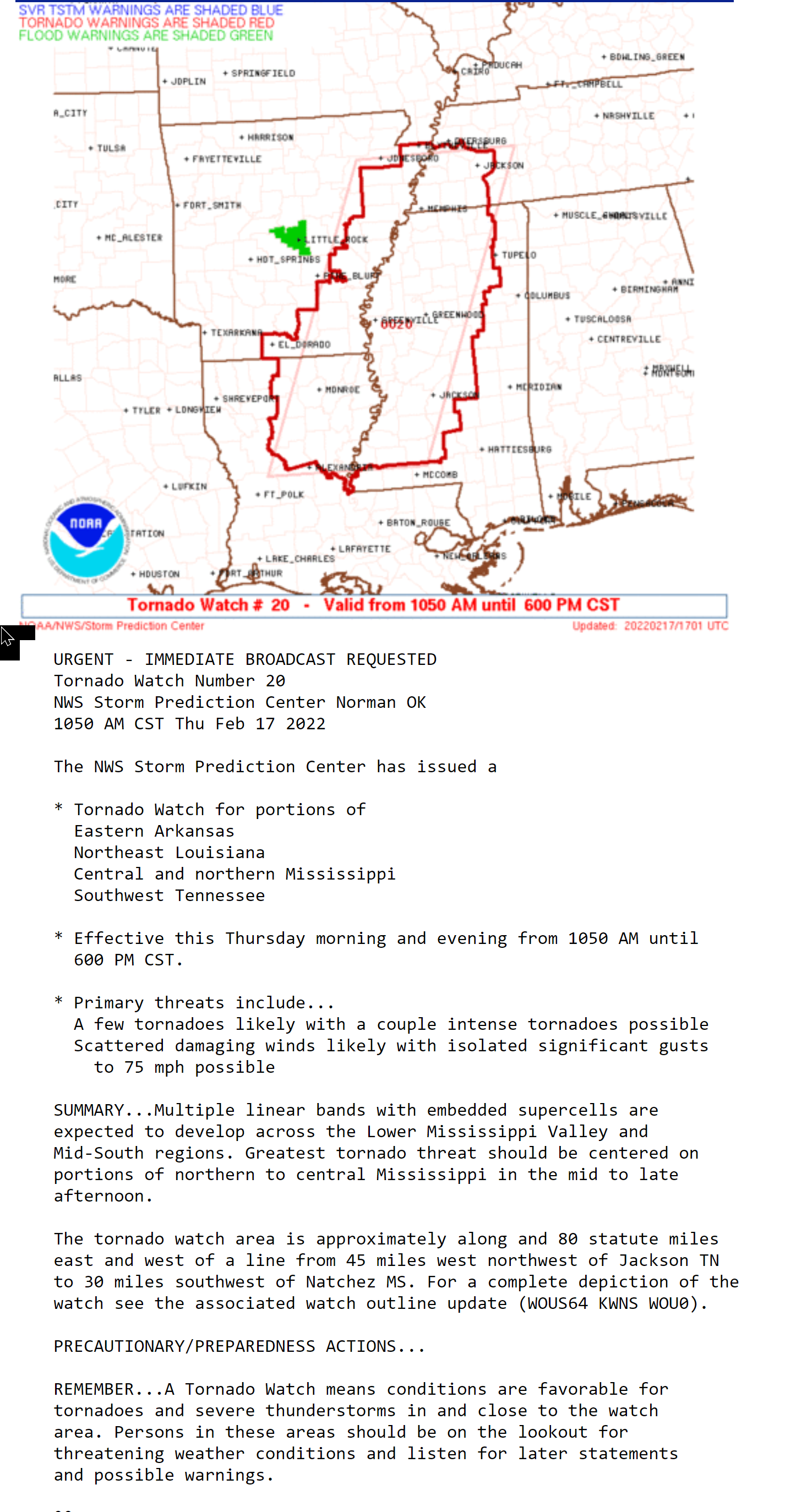
A tornado watch has been issued for areas just south of my forecast counties.
.
11 AM
PAH issues Areal Flood Warning for Fulton [KY] and Bollinger, Butler, Carter, New Madrid, Ripley, Stoddard, Wayne [MO] till 7:00 PM CST
PAH issues Areal Flood Warning for Edwards, Franklin, Gallatin, Hamilton, Hardin, Jackson, Jefferson, Saline, Wabash, Wayne, White, Williamson [IL] and Posey [IN] till 5:00 PM CST
.
10:20 AM
Storm Prediction Center update. A tornado watch is likely to be issued for portions of western Tennessee. We will have to see how far north they take the watch.
Double click the image to enlarge it.
.
10:15 AM
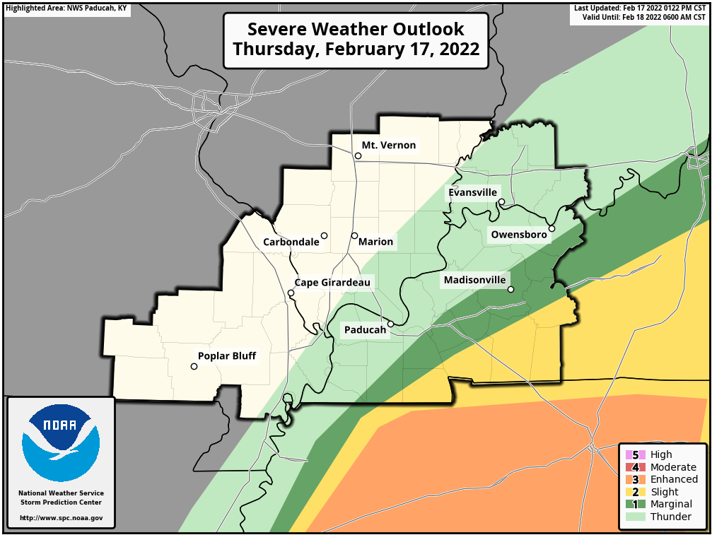
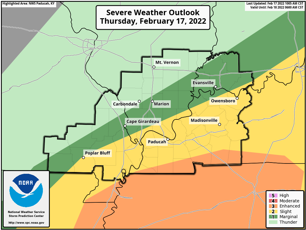
The SPC has shifted the enhanced northward just a tad. This covers the area I have been concerned about, as well.
There remain questions about whether or not the atmosphere will be unstable enough to product damaging wind and tornadoes. We will just have to monitor the situation through the afternoon hours.
The thick black outline is simply the Paducah, Kentucky NWS forecast area.
Light green represents sub-severe storms. Lightning is the concern.
Dark green is a level one out of five severe weather risk. The lowest risk.
Yellow is a level two out of five severe weather risk.
The orange zone is a level three out of five severe weather risk.
The highest risk on this graphic would be the orange zone (level three).
Don’t get too caught up in the colors. A severe thunderstorm is a severe thunderstorm. Whether it occurs in the green zone or the orange zone.
.
10 AM
PAH issues Areal Flood Warning for Caldwell, Christian, Hopkins, McLean, Muhlenberg, Todd, Trigg, Webster [KY] till 6:45 PM CST
PAH issues Areal Flood Warning for Alexander, Massac, Pope [IL] and Ballard, Caldwell, Carlisle, Crittenden, Fulton, Graves, Hickman, Hopkins, Livingston, Lyon, Marshall, McCracken, Trigg [KY] and Mississippi, New Madrid [MO] till 5:15 PM CST
PAH issues Areal Flood Warning for Alexander, Pulaski, Union [IL] and Bollinger, Cape Girardeau, Scott, Stoddard [MO] till 1:30 PM CST
.
10 AM
The low pressure center is now in central Arkansas. Severe weather will be higher along and south southeast of the track of that low.
It is moving northeast towards western Kentucky.
There is a lot of rain and clouds. This is good. That will at least help keep the atmosphere somewhat stable.
Hopefully the clouds and rain will linger into the afternoon and keep the atmosphere somewhat more stable.
.
9:45 AM
Flooding has been reported in the following areas.
McCracken County
KY 1327/Lovelaceville Rd at 5.5 to 6.5mm
KY 339/Clinton Rd at 6.2 to 6.4mm
KY 994/Old Mayfield Rd at 5.5 to 5.7mm
KY 1014/Houser Rd at 3.2 to 3.7mm
KY 1565/Mayfield-Metropolis Rd at 4.5 to 5.5mm between U.S. 60 and KY 305
KY 1438/New Hope Church Rd at 3mm near New Hope Church
Marshall County
U.S. 641 in Marshall County between KY Dam Village State Park and Draffenville
.
9:15 AM
PADUCAH, Ky. (Feb. 17, 2022) – Kentucky Transportation Cabinet (KYTC) District 1 is advising motorists to use extra caution as flash flooding has been reported at numerous locations along area highways. Many of these locations are in areas where flooding has not been reported in the past.
Motorists should be alert for flooded roadways due to heavy bands of rainfall moving across the region during the day.
SPECIFIC LOCATIONS
- U.S. 641 in Marshall County between KY Dam Village State Park and Draffenville
- KY 1438 in Southern McCracken County near New Hope Church
There are likely other locations that have not been reported. KYTC personnel will be placing WATER OVER ROAD signs at appropriate locations. However, due to widespread roadway flooding during the day crews may be unable to mark all flooded roadways. Caution is required.
.
9 AM
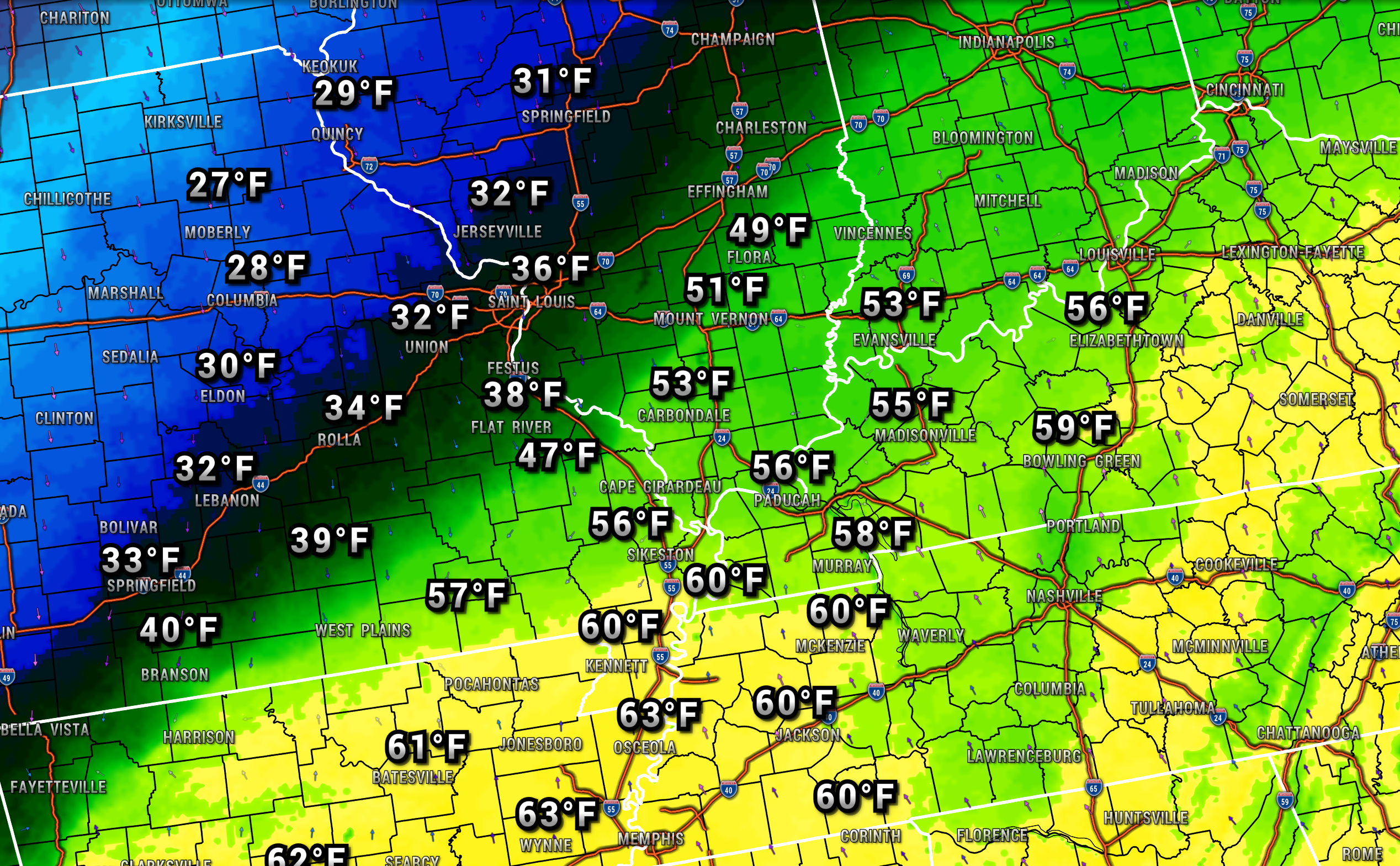
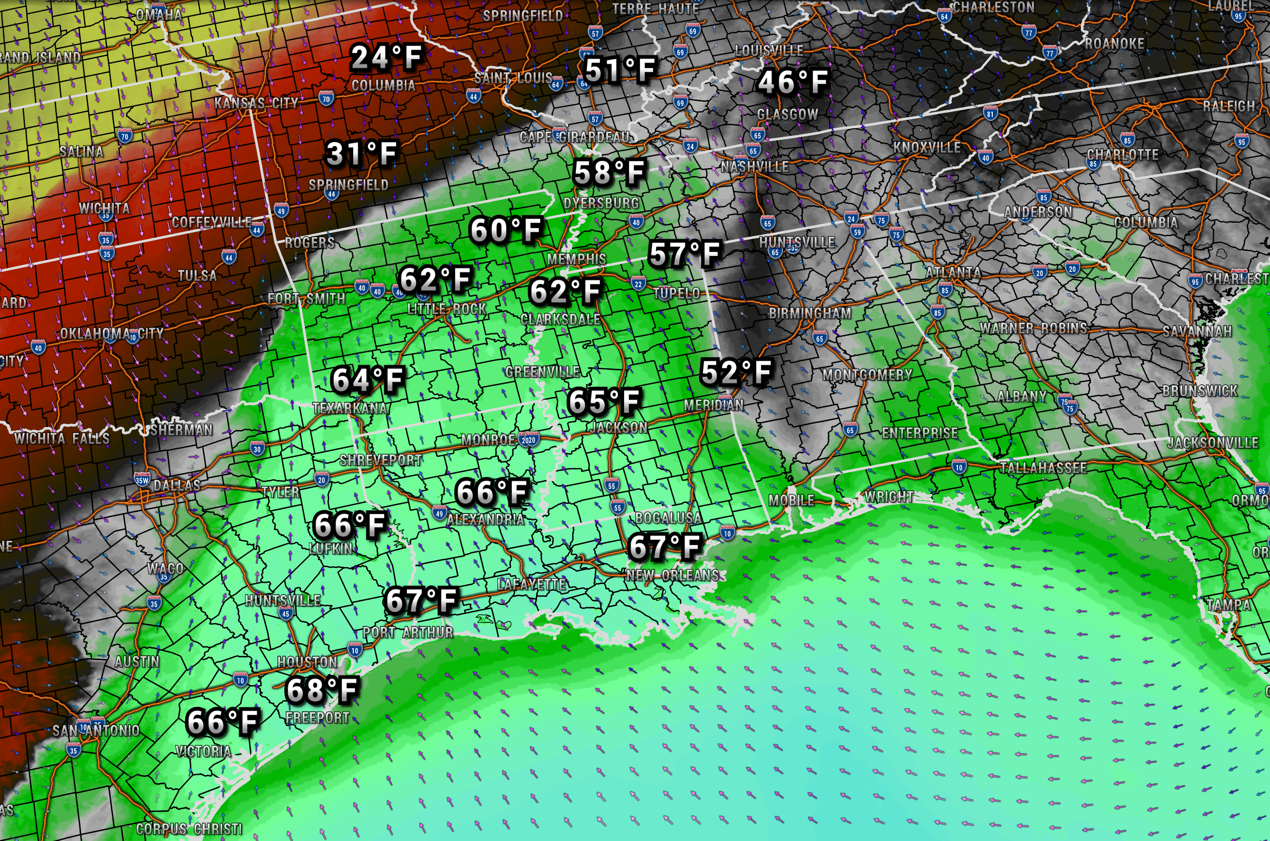
A wide range of temperatures across the region. You can see where the cold front is situated.
Double click images on the blog to enlarge them.
.
8:25 AM
Ste Genevieve, Randolph, Perry, and Jefferson Counties.
Model guidance has trended colder for today. The rain may end as a wintry mix.
A mixture of freezing rain, sleet, and snow may develop in response to the falling temperatures. This would most likely occur this afternoon and evening.
It will take time for surfaces to cool down. Temperatures were mild over the last few days.
Remember, elevated surfaces freeze first. Use caution on bridges and overpasses. The same goes for decks, porches, and sidewalks.
Precipitation amounts won’t be all that great. The concern is mainly impacts. Icy conditions on some surfaces.
.
he SPC is monitoring Arkansas for a possible severe weather watch.
.
7:30 AM Update
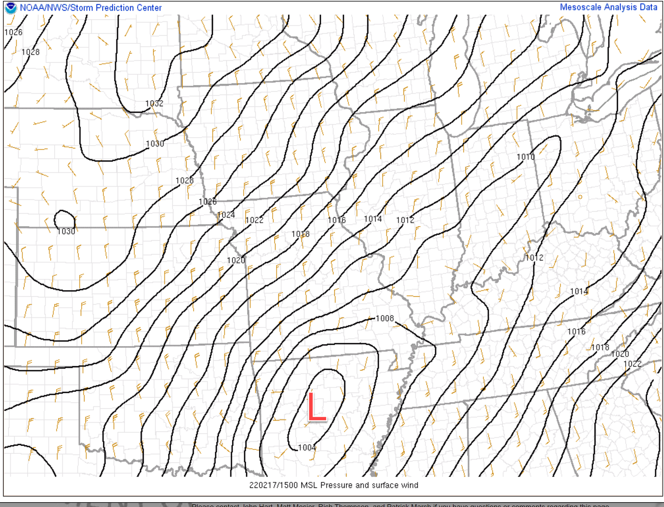
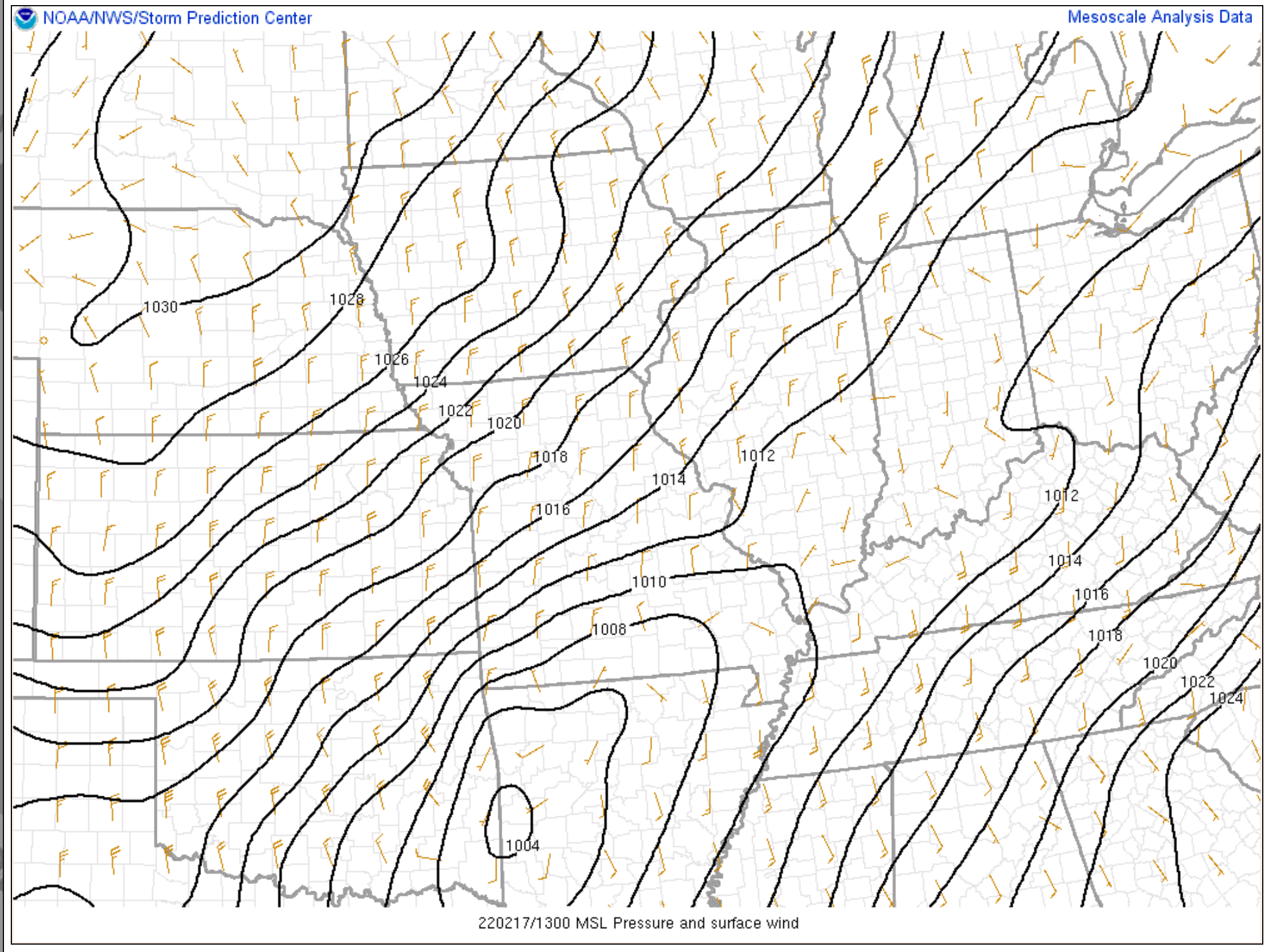
We will be tracking an area of low pressure today as it moves out of Arkansas.
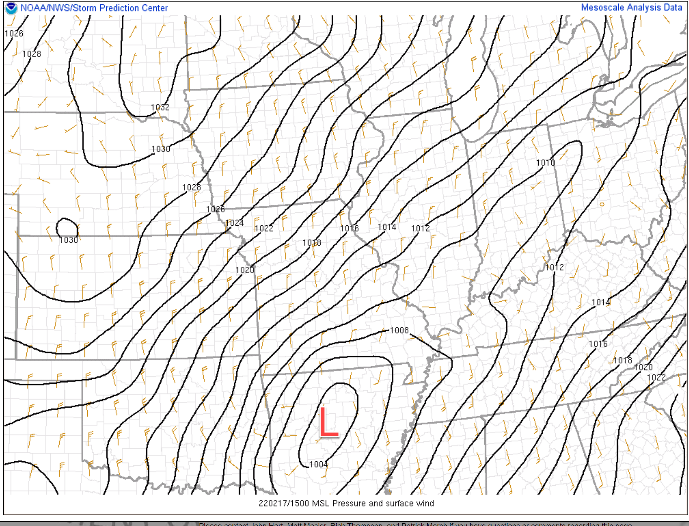
Here is its present location.
You can see the closed isobars in southwest Arkansas. That is the area of low pressure. The greatest severe risk will be near and south of that low. It will move northeast into western Kentucky later today.
Those black lines are equal lines of barometric pressure. Tightly packed isobars equal strong and gusty gradient winds.
The low is currently at 1004 isobars. It will deepen as it moves northeast.
Dew points are on the rise.
For severe weather to develop, we typically look for dew points in the upper 50s and 60s.
The 60 degree line is approaching the Missouri Bootheel and is already in portions of western Tennessee.
These dew points will push northeast throughout the day.
.
Gusty winds today.
We will have strong and gusty gradient winds today. Gradient winds are caused by rapidly falling and rising barometric pressure. Your home barometer will be falling today.
Low pressure will push into our region this afternoon and depart this evening. This is what will cause the pressure change.
Gradient winds are caused by these changes in pressure.
Widespread 15 to 30 mph winds are anticipated today with occasional gusts into the 40 to 50 mph range (perhaps isolated higher numbers).
These gradient winds could bring down tree limbs. Power outages can’t be ruled out, as well.
The winds will begin to subside tonight.
.
Locally heavy rain today.
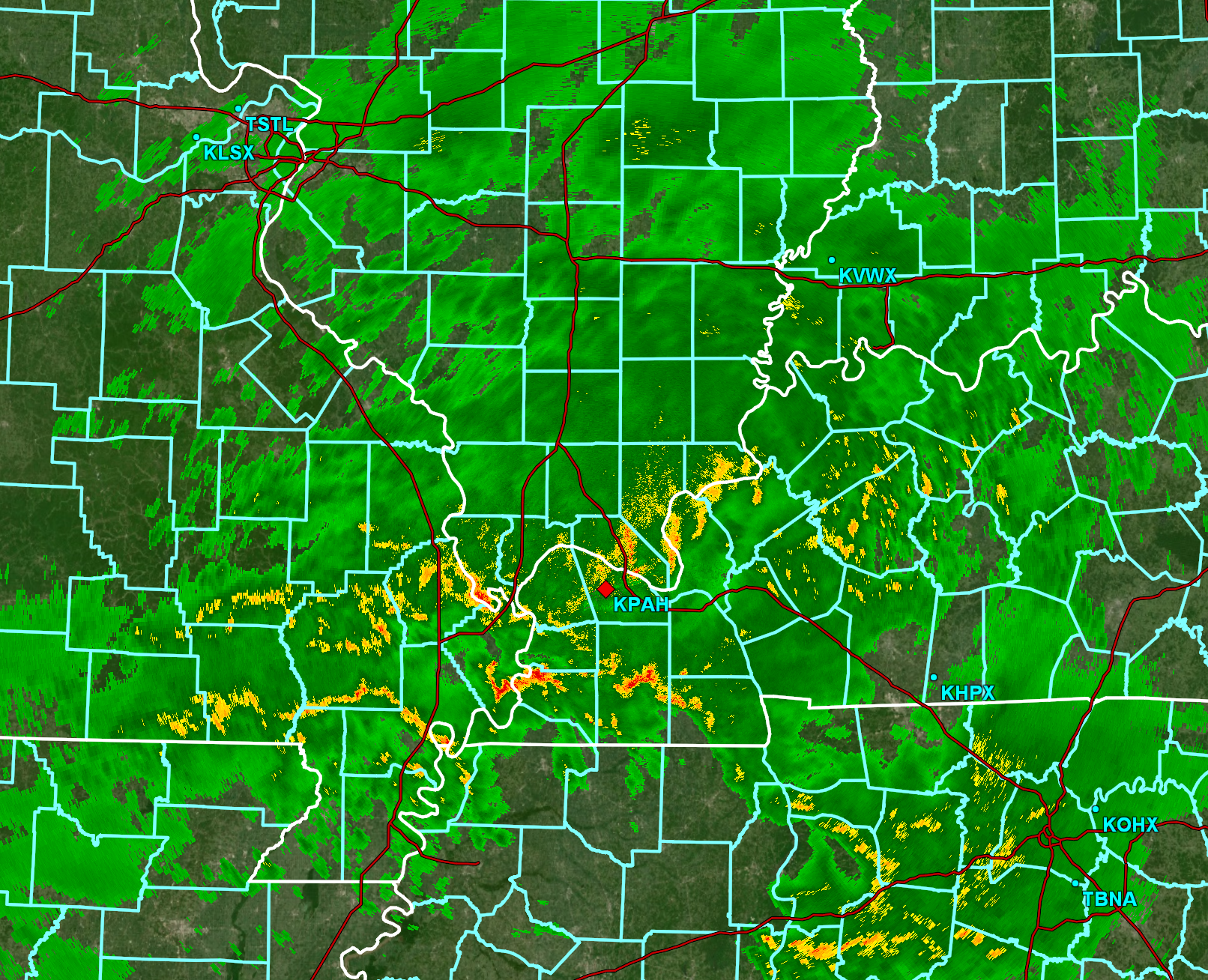
We are waking up to widespread rain. Showers and thunderstorms cover much of the radar.
Radar at 7 AM showed this. Quite a big of rain in the region. Some thunderstorms, as well.
Rain will continue on and off throughout today.
Some of the rain will be heavy. If thunderstorms train over the same area then some areas could easily receive two to three inches of rain.
This heavy rain could cause ditches to overflow and creeks/streams to rapidly rise. Some flood warnings are certainly possible.
Avoid flooded roadways, as always.
Rain will taper off late this afternoon and evening. Ending this evening/tonight.
The rain may briefly change to a wintry mix over our northern counties. Little or no accumulation.
.
The risk of severe thunderstorms today.
Here is the official SPC severe weather outlook.
The thick black outline is simply the Paducah, Kentucky NWS forecast area.
Light green represents sub-severe storms. Lightning is the concern.
Dark green is a level one out of five severe weather risk. The lowest risk.
Yellow is a level two out of five severe weather risk.
The orange zone is a level three out of five severe weather risk.
The highest risk on this graphic would be the orange zone (level three).
Don’t get too caught up in the colors. A severe thunderstorm is a severe thunderstorm. Whether it occurs in the green zone or the orange zone.
It only takes one severe thunderstorm or one tornado to ruin the day. So, let’s be on alert today/this afternoon for the potential of severe weather watches and warnings.
Remember, a warning is more serious. It means to take immediate action. A severe weather event is imminent in or near your location.

Discussion.
The biggest concern with this system has been the potential of severe thunderstorms.
This has been a difficult system to forecast. We are right on the edge of better instability to our south and less instability to our north.
Instability is necessary when forecasting severe thunderstorms.
The risk of severe weather will be greater as you travel southward today. The risk will be lower as you travel northward.
At this time, it appears the area of low pressure is going to end up tracking fairly far south compared to what models had been showing the last four or five days. This is one reason that I have been hesitant to pound the severe weather drums. Not until confidence increased on the final outcome.
The highest risk of severe weather is going to run from the Missouri Bootheel into western Kentucky and northwest Tennessee. The risk may be a tad higher from the Kentucky/Tennessee border southward.
Areas to the north could also see severe weather, but the risk appears lower.
The primary concern will be lightning and damaging wind gusts.
Wind shear with this system is near the top of the charts. Wind shear is the change of wind direction and speed as you move up into the atmosphere.
There is no lack of wind shear with this event.
What is lacking is CAPE. CAPE is basically energy that thunderstorms tap into to become severe.
This is a low CAPE set-up. That is typical for February. High shear and low CAPE.
It does not take much CAPE to cause severe thunderstorms during the winter months. The shears makes up for the lack of CAPE. It does, however, take some CAPE.
I will be monitoring CAPE throughout today.
Plan on some severe thunderstorm warnings later today/this afternoon. I can’t rule out tornado warnings, as well.
Any thunderstorms that can become surface based could spin. Thus, a tornado is certainly not out of the questions.
Storms will be moving east/northeast in excess of 50 mph. Fast moving storms. This will not give you a lot of time to seek shelter if a tornado were to develop.
Know your families safety plan in the event severe weather develops.
Have multiple ways of receiving severe weather information. Not just my weather app. Have other ways, as well. All technology can fail. Thus, having more than one source will help keep you safe.
Remember, a WATCH means to monitor updates. You don’t have to change your behavior for a watch. Be prepared.
A WARNINGis more serious. A WARNINGmeans severe weather is imminent in or near your location. A WARNING means to seek shelter.
.
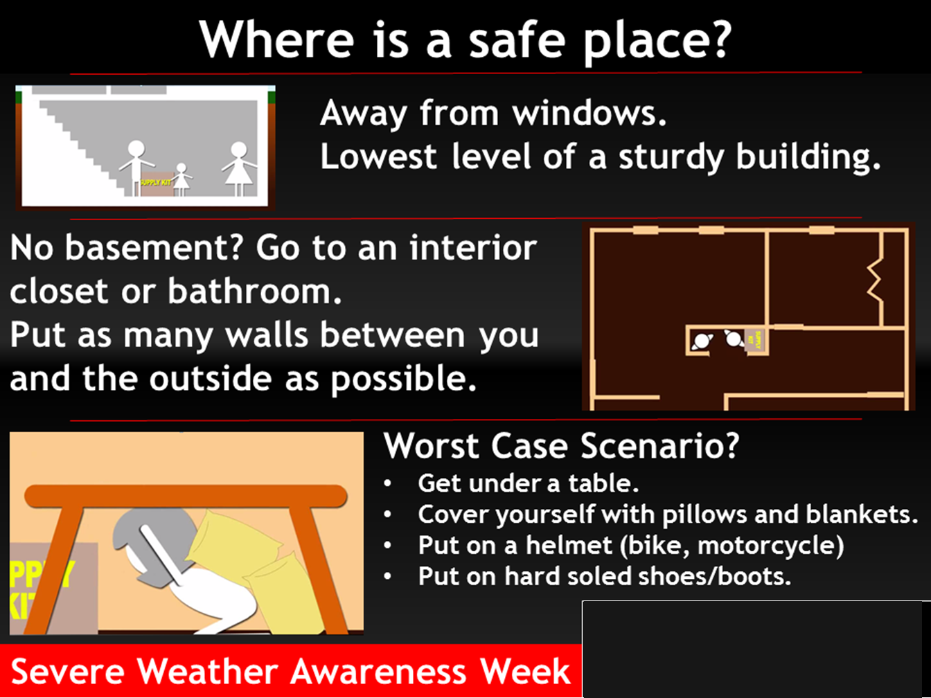
Where is a safe place to hide when tornadoes threaten your location.
.

Click here if you would like to return to the top of the page.
Again, as a reminder, these are models. They are never 100% accurate. Take the general idea from them.
What should I take from these?
- The general idea and not specifics. Models usually do well with the generalities.
- The time-stamp is located in the upper left corner.
- The EC European weather model is in Zulu time.
.
What am I looking at?
You are looking at different models. Meteorologists use many different models to forecast the weather. All models are wrong. Some are more wrong than others. Meteorologists have to make a forecast based on the guidance/models.
I show you these so you can see what the different models are showing as far as precipitation. If most of the models agree, then the confidence in the final weather forecast increases.
.
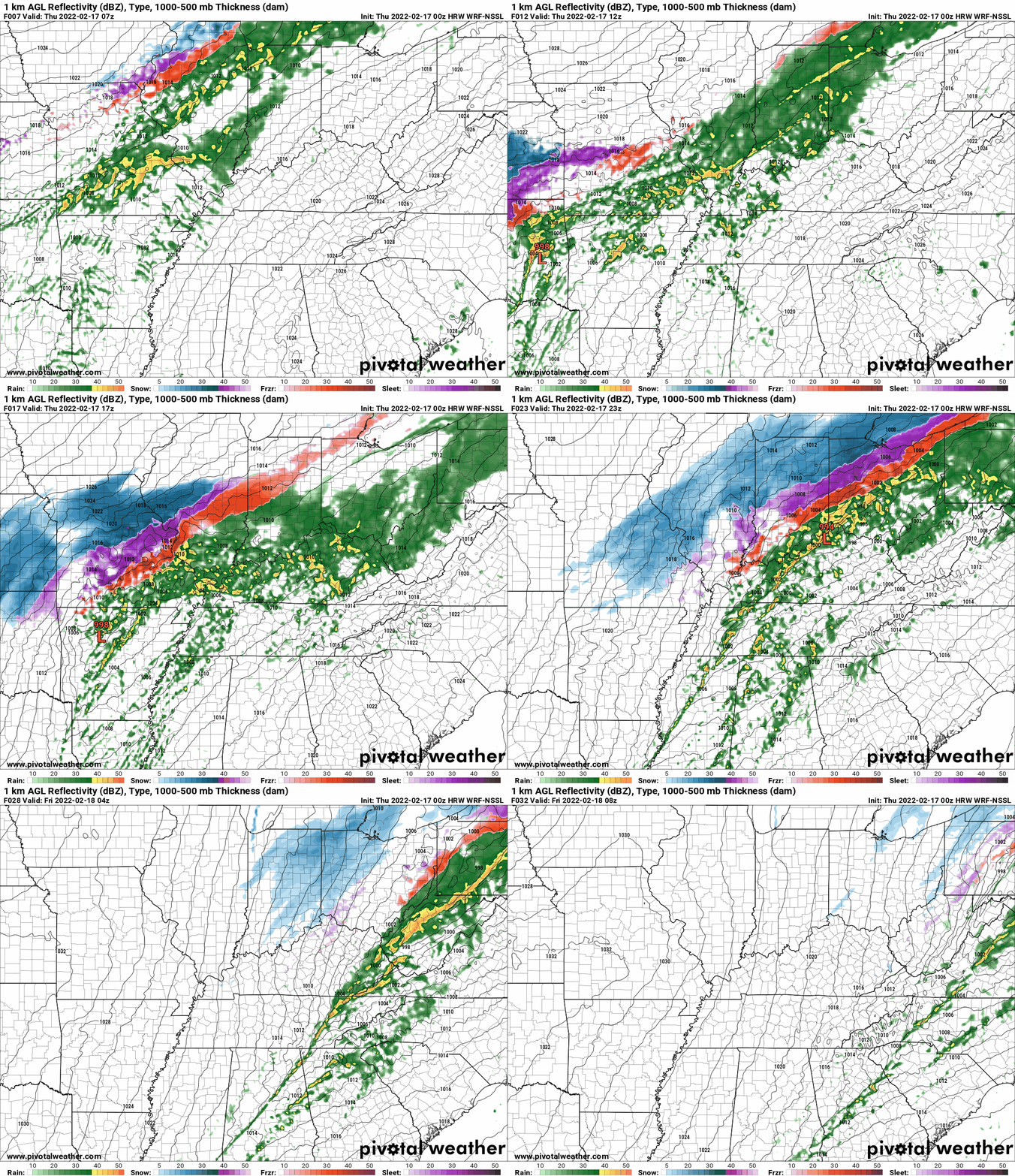
This animation is the Storm Prediction Center WRF model.
This animation shows you what radar might look like as the next system pulls through the region. It is a future-cast radar.
Time-stamp upper left. Click the animation to enlarge it.
.
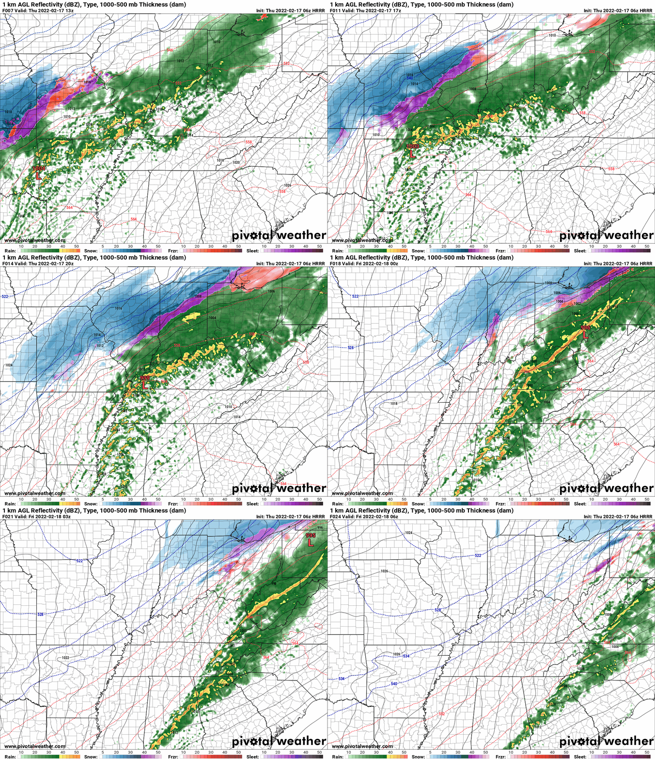
This animation is the Hrrr short-range model.
This animation shows you what radar might look like as the next system pulls through the region. It is a future-cast radar.
Time-stamp upper left. Click the animation to enlarge it.
Double click the animation to enlarge it.
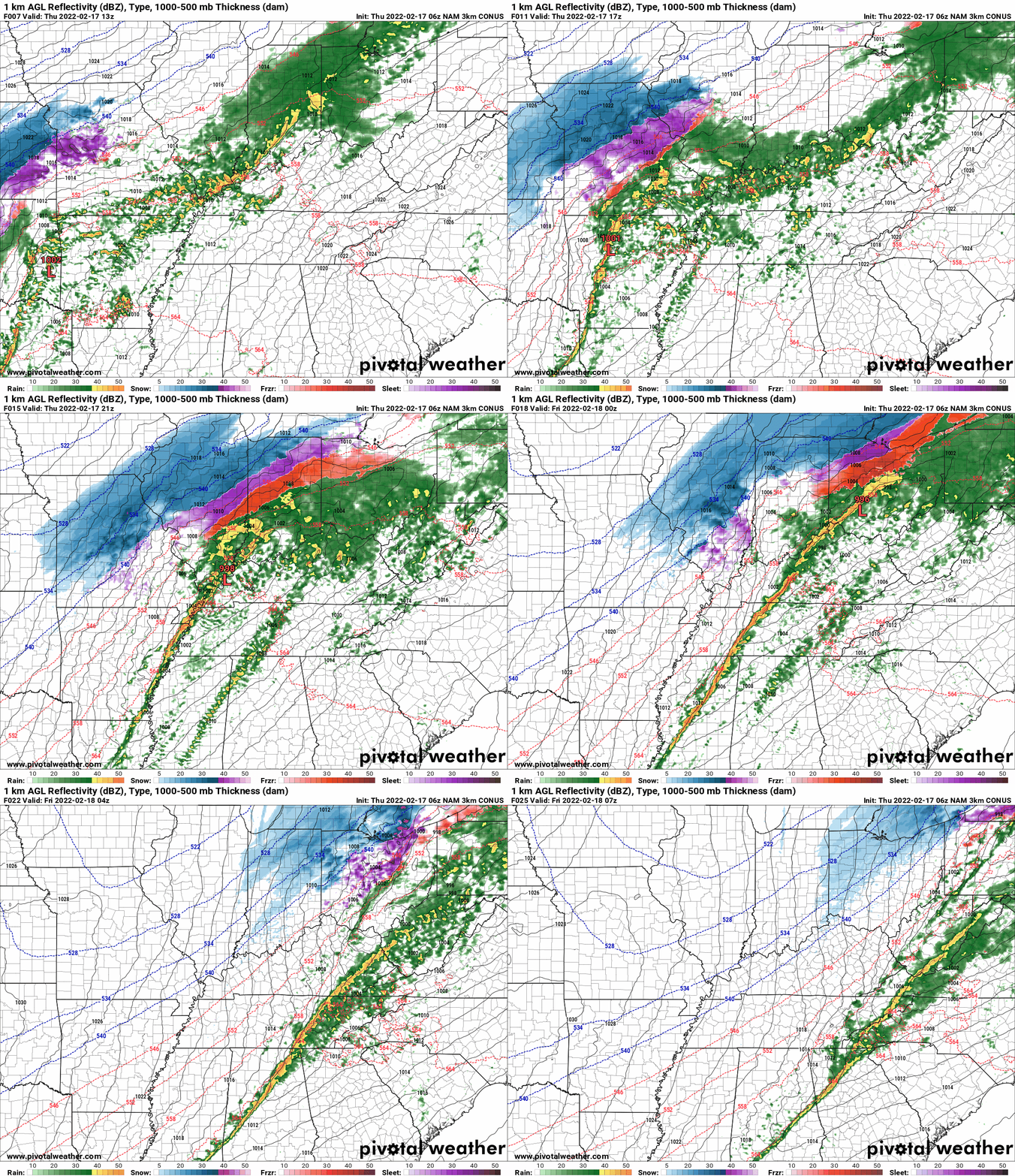
These maps are in Zulu time. 12z=6 AM. 18z=12 PM. 00z=6 PM. 06z=12 AM
.
.This animation is the higher-resolution 3K NAM American Model.
Double click the animation to enlarge it.
Time is in Zulu. 12z=6 AM. 18z=12 PM. 00z=6 PM. 06z=12 AM
.
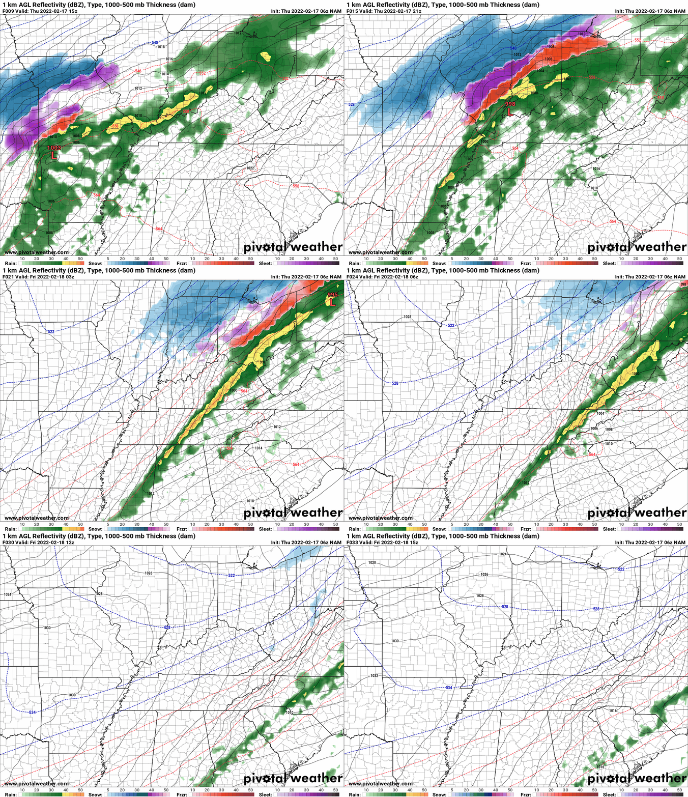
This next animation is the lower-resolution NAM American Model.
This animation shows you what radar might look like as the system pulls through the region. It is a future-cast radar.
Time-stamp upper left. Click the animation to enlarge it.
Time is in Zulu. 12z=6 AM. 18z=12 PM. 00z=6 PM. 06z=12 AM
![]()
Today’s severe weather outlook from the Storm Prediction Center (below).
Light green is where thunderstorms may occur but should be below severe levels.
Dark green is a level one risk. Yellow is a level two risk. Orange is a level three (enhanced) risk. Red is a level four (moderate) risk. Pink is a level five (high) risk.
One is the lowest risk. Five is the highest risk.
A severe storm is one that produces 58 mph wind or higher, quarter size hail, and/or a tornado.
The tan states are simply a region that SPC outlined on this particular map. Just ignore that.

The black outline is our local area.

.
Tomorrow’s severe weather outlook.

.
SUBSCRIBERS: Download the WeatherTalk app to keep abreast of my latest information.
The app is for subscribers. Subscribe at www.weathertalk.com/welcome then go to your app store and search for WeatherTalk
Subscribers, PLEASE USE THE APP. ATT and Verizon are not reliable during severe weather. They are delaying text messages.
The app is under WeatherTalk in the app store.
Apple users click here
Android users click here
![]()
![]()
.

Radar Link: Interactive local city-view radars & regional radars.
You will find clickable warning and advisory buttons on the local city-view radars.
If the radar is not updating then try another one. If a radar does not appear to be refreshing then hit Ctrl F5. You may also try restarting your browser.
Not working? Email me at beaudodson@usawx.com
Backup radar site in case the above one is not working.
https://weathertalk.com/morani
New ZOOM radar (with storm chasers)
https://wtalk.co/AVWG7GM7
Regional Radar
https://imagery.weathertalk.com/prx/RadarLoop.mp4
Lightning Data (zoom in and out of your local area)
https://wtalk.co/WJ3SN5UZ
Satellite Data
Computers and tablets. These two satellite links may not work well on cell phones.
Visible Satellite. This one is to be used during daylight only. Be sure and hit refresh once you are on the satellite page. Otherwise, the data will be old.
https://col.st/a5A0e
IR Satellite. This one shows cloud temperatures. Bright colors represent cold cloud tops. That could mean thunderstorms. Be sure and hit refresh once you are on the satellite page. Otherwise, the data will be old.
https://col.st/R2fw1
Water Vapor Satellite. This one shows mid-level moisture in the atmosphere. Be sure and hit refresh once you are on the satellite page. Otherwise, the data will be old.
https://col.st/xFVwx
.

Live lightning data: Click here.
Not receiving app/text messages?
Log in and out of your app.
USE THE APP. ATT and Verizon are slowing or stopping the text messages. Move to the app (not texts).
Make sure you have the correct app/text options turned on. Find those under the personal notification settings tab at www.weathertalk.com. Red is off. Green is on.
Subscribers, PLEASE USE THE APP. ATT and Verizon are not reliable during severe weather. They are delaying text messages.
The app is under WeatherTalk in the app store.
Apple users click here
Android users click here
.


