
Your daily forecast into the coming weekend.
December 27, 2017
Wednesday Night Forecast Details:
Forecast: Partly cloudy. Cold. Low wind chills.
Temperatures: MO ~ +6 to 14 IL ~ +6 to 12 KY ~ +8 to 14
What is the chance of precipitation? MO ~ 10% IL ~ 10% KY ~ 10%
Coverage of precipitation: Most likely none
Wind chill values: -5 to 10 above
Accumulating snow or ice: Unlikely
Winds: East and northeast at 5 to 10 mph
What impacts are anticipated from the weather? Low wind chills.
My confidence in the forecast verifying: High
Is severe weather expected? No
The NWS defines severe weather as 58 mph wind or great, 1″ hail or larger, and/or tornadoes
Should I cancel my outdoor plans: No, but it will be cold
.
December 28, 2017
Thursday Forecast Details
Forecast: A mix of sun and clouds. Slight chance of flurries. Increasing clouds through the day.
Temperatures: MO ~ 25 to 32 IL ~ 24 to 30 KY ~ 28 to 32
What is the chance of precipitation? MO ~ 10% IL ~ 20% KY ~ 10%
Coverage of precipitation: Most likely none
Wind chill values: 10 to 20
Accumulating snow or ice: No
Winds: Variable winds at 6 to 12 mph
What impacts are anticipated from the weather? Low wind chills.
My confidence in the forecast verifying: High
Is severe weather expected? No
The NWS defines severe weather as 58 mph wind or great, 1″ hail or larger, and/or tornadoes
Should I cancel my outdoor plans? No, but it will be cold
.
Thursday Night Forecast Details:
Forecast: Partly cloudy and cold.
Temperatures: MO ~ 15 to 20 IL ~ 14 to 18 KY ~ 15 to 20
What is the chance of precipitation? MO ~ 10% IL ~ 10% KY ~ 10%
Coverage of precipitation: Most likely none
Wind chill values: 10 to 15
Accumulating snow or ice: No
Winds: West winds at 0 to 5 mph
What impacts are anticipated from the weather? Low wind chills.
My confidence in the forecast verifying: High
Is severe weather expected? No
The NWS defines severe weather as 58 mph wind or great, 1″ hail or larger, and/or tornadoes
Should I cancel my outdoor plans: No, but it will be cold
.
December 29, 2017
Friday Forecast Details
Forecast: Partly sunny morning. Afternoon clouds. A few snow flurries or snow showers possible (esp northern portions of southern Illinois into northwest Kentucky). No accumulation to a dusting. Odds favor no accumulation.
Temperatures: MO ~ 32 to 36 IL ~ 30 to 35 KY ~ 32 to 36
What is the chance of precipitation? MO ~ 10% IL ~ 20% KY ~ 20%
Coverage of precipitation: Scattered over our north and northeast counties
Wind chill values: 15 to 25
Accumulating snow or ice: Unlikely. Small chance of a dusting.
Winds: North and northwest at 5 to 10 mph with gusts to 15 mph
What impacts are anticipated from the weather? Cold wind chills. I will monitor the snow chances. Dusting possible for some.
My confidence in the forecast verifying: Medium
Is severe weather expected? No
The NWS defines severe weather as 58 mph wind or great, 1″ hail or larger, and/or tornadoes
Should I cancel my outdoor plans? No, but it will be cold
.
Friday Night Forecast Details:
Forecast: Cloudy and cold. A slight chance of snow showers or flurries.
Temperatures: MO ~ 15 to 20 IL ~ 15 to 20 KY ~ 15 to 20
What is the chance of precipitation? MO ~ 20% IL ~ 20% KY ~ 20%
Coverage of precipitation: Isolated
Wind chill values: 5 to 15 degrees
Accumulating snow or ice: Unlikely
Winds: North at 5 to 10 mph
What impacts are anticipated from the weather? Cold wind chills.
My confidence in the forecast verifying: Medium
Is severe weather expected? No
The NWS defines severe weather as 58 mph wind or great, 1″ hail or larger, and/or tornadoes
Should I cancel my outdoor plans: No, but it will be cold
.
December 30, 2017
Saturday Forecast Details
Forecast: Quite a few clouds. Flurries or snow showers possible. Little or no accumulation anticipated.
Temperatures: MO ~ 24 to 28 IL ~ 24 to 28 KY ~ 26 to 32
What is the chance of precipitation? MO ~ 20% IL ~ 20% KY ~ 20%
Coverage of precipitation: Isolated
Wind chill values: 5 to 15 above
Accumulating snow or ice: Unlikely
Winds: North and northeast at 6 to 12 mph with gusts to 20
What impacts are anticipated from the weather? Low wind chills
My confidence in the forecast verifying: Medium
Is severe weather expected? No
The NWS defines severe weather as 58 mph wind or great, 1″ hail or larger, and/or tornadoes
Should I cancel my outdoor plans? No, but it will be cold
.
Saturday Night Forecast Details:
Forecast: Cloudy with snow showers possible. Bitterly cold.
Temperatures: MO ~ +4 to 8 IL ~ +4 to 8 KY ~ +6 to 12
What is the chance of precipitation? MO ~ 10% IL ~ 10% KY ~ 10%
Coverage of precipitation: Perhaps spotty
Wind chill values: -10 to 10 above
Accumulating snow or ice: Slight chance
Winds: North and northeast at 5 to 10 mph with gusts to 15 mph
What impacts are anticipated from the weather? Bitterly cold wind chills.
My confidence in the forecast verifying: Medium
Is severe weather expected? No
The NWS defines severe weather as 58 mph wind or great, 1″ hail or larger, and/or tornadoes
Should I cancel my outdoor plans: No, but it will be cold
.
December 31, 2017
Sunday Forecast Details
Forecast: Some clouds. Flurries possible.
Temperatures: MO ~ 15 to 22 IL ~ 15 to 22 KY ~ 18 to 22
What is the chance of precipitation? MO ~ 20% IL ~ 20% KY ~ 20%
Coverage of precipitation: Scattered snow flurries or snow showers possible
Wind chill values: -10 to 15 above
Accumulating snow or ice: No
Winds: North and northeast at 6 to 12 mph with gusts to 20 mph
What impacts are anticipated from the weather? Cold wind chills
My confidence in the forecast verifying: Medium
Is severe weather expected? No
The NWS defines severe weather as 58 mph wind or great, 1″ hail or larger, and/or tornadoes
Should I cancel my outdoor plans? No, but it will be cold
.
Sunday Night Forecast Details:
Forecast: Partly cloudy.
Temperatures: MO ~ +3 to 8 IL ~ +2 to 10 KY ~ +5 to 10
What is the chance of precipitation? MO ~ 10% IL ~ 10% KY ~ 10%
Coverage of precipitation: Most likely none
Wind chill values: -15 to 10 degrees above
Accumulating snow or ice: No
Winds: North at 8 to 16 mph
What impacts are anticipated from the weather? Bitterly cold
My confidence in the forecast verifying: Medium
Is severe weather expected? No
The NWS defines severe weather as 58 mph wind or great, 1″ hail or larger, and/or tornadoes
Should I cancel my outdoor plans: No, but it will be cold
.
January 1, 2018
Monday Forecast Details
Forecast: Partly to mostly sunny. Cold.
Temperatures: MO ~ 16 to 22 IL ~ 15 to 20 KY ~ 18 to 24
What is the chance of precipitation? MO ~ 10% IL ~ 10% KY ~ 10%
Coverage of precipitation: None
Wind chill values: -5 to 15 above
Accumulating snow or ice: No
Winds: North and northeast at 6 to 12 mph
What impacts are anticipated from the weather? Cold wind chills.
My confidence in the forecast verifying: Medium
Is severe weather expected? No
The NWS defines severe weather as 58 mph wind or great, 1″ hail or larger, and/or tornadoes
Should I cancel my outdoor plans? No, but it will be cold
.
Monday Night Forecast Details:
Forecast: Mostly clear and bitterly cold.
Temperatures: MO ~ -1 to +6 IL ~ -1 to +6 KY ~ 4 to 8
What is the chance of precipitation? MO ~ 0% IL ~ 0% KY ~ 0%
Coverage of precipitation: Most likely none
Wind chill values: -15 to 5 degrees above
Accumulating snow or ice: No
Winds: North winds at 5 to 10 mph with gusts to 14
What impacts are anticipated from the weather? Cold wind chills
My confidence in the forecast verifying: Medium
Is severe weather expected? No
The NWS defines severe weather as 58 mph wind or great, 1″ hail or larger, and/or tornadoes
Should I cancel my outdoor plans: No, but it will be cold
.
January 2, 2018
Tuesday Forecast Details
Forecast: Sunny. Cold.
Temperatures: MO ~ 18 to 24 IL ~ 18 to 24 KY ~ 20 to 25
What is the chance of precipitation? MO ~ 0% IL ~ 0% KY ~ 0%
Coverage of precipitation: None
Wind chill values: +5 to 15 above
Accumulating snow or ice: No
Winds: North and northeast at 6 to 12 mph. Winds becoming variable.
What impacts are anticipated from the weather? Cold wind chills.
My confidence in the forecast verifying: Medium
Is severe weather expected? No
The NWS defines severe weather as 58 mph wind or great, 1″ hail or larger, and/or tornadoes
Should I cancel my outdoor plans? No, but it will be cold
.
Tuesday Night Forecast Details:
Forecast: Mostly clear and bitterly cold.
Temperatures: MO temp range 7 to 16 IL temp range 6 to 12 KY temp range 7 to 14
What is the chance of precipitation? MO ~ 0% IL ~ 0% KY ~ 0%
Coverage of precipitation: Most likely none
Wind chill values: -15 to 5 degrees above
Accumulating snow or ice: No
Winds: North winds at 4 to 8 mph
What impacts are anticipated from the weather? Cold wind chills
My confidence in the forecast verifying: Medium
Is severe weather expected? No
The NWS defines severe weather as 58 mph wind or great, 1″ hail or larger, and/or tornadoes
Should I cancel my outdoor plans: No, but it will be cold
.

.
Wednesday night through next Monday: Periodic snow flurry or snow shower chances. Bitterly cold air. Widespread accumulating snow is unlikely. Spotty dusting to an inch accumulation not out of the question, but would likely not be the norm.
I will monitor trends in case a system tracks further south than anticipated.
.

.
The National Weather Service definition of a severe thunderstorm is one that produces quarter size hail or larger, 58 mph winds or greater, and/or a tornado.
Now through next Friday: Severe storms are not anticipated.
.

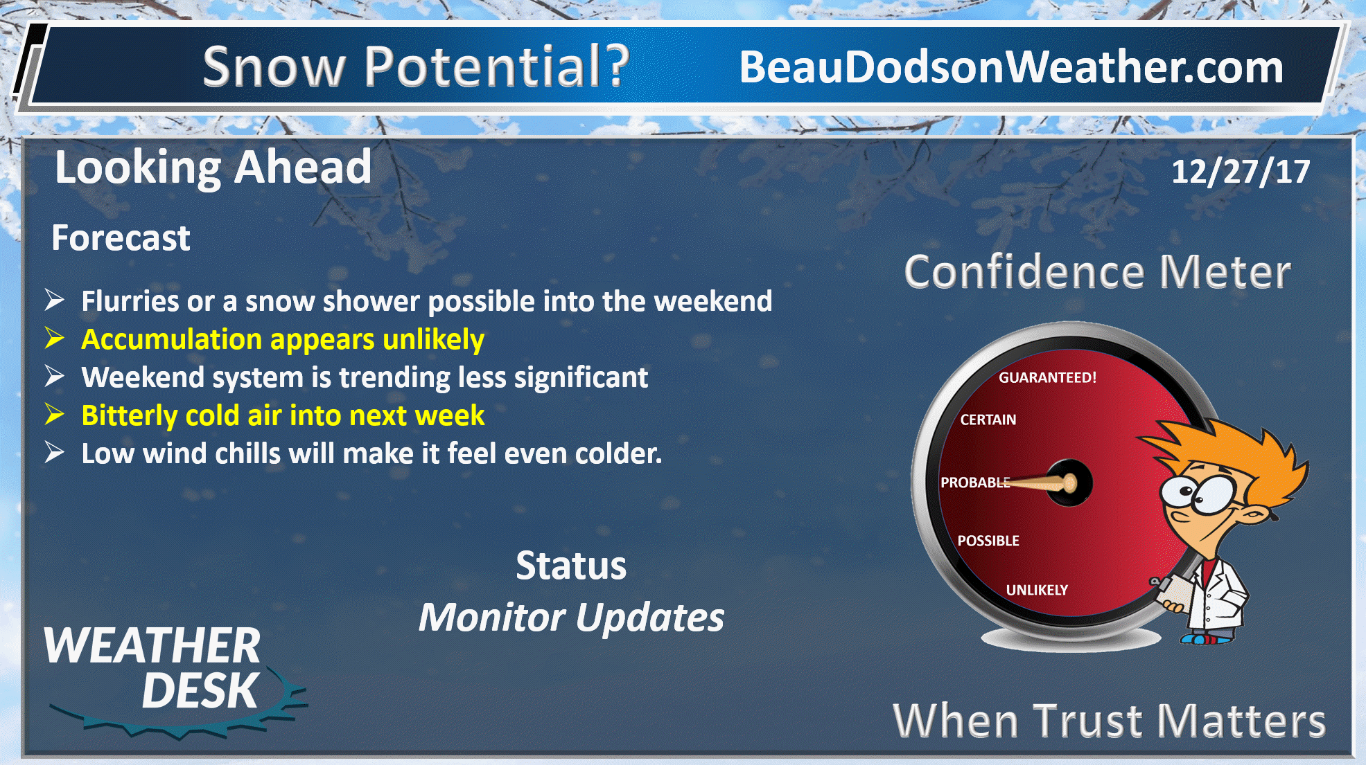
Forecast
Plan on cold weather into next week. Some of the morning lows will dip into the single digits.
There is the potential for bitterly cold air to cause problems in the region. Snow chances don’t look all that great. Flurries or snow showers are more likely than anything else.
Monitor updated forecasts over the coming days.
Interactive Weather Radar Page. Choose the city nearest your location: Click this link
Reminders
.
.
Today into Friday
More of the same. Cold days and cold nights. A few clouds with occasional flurries or snow showers. At this time, there are no major snow events on the horizon.
Farmers will want to monitor temperature forecasts over the coming days. We will remain locked into the cold temperatures into next week. Several nights will dip into the single digits.
See the detailed daily outlook at the bottom of this post.
Several fast moving clipper systems will nick our region. The snow will mainly stay to our north.
If one of these fast moving weak systems were to track slightly further south, then our northern counties could pick up a dusting to an inch of snow. See snow probability maps below.
Highs will be in the 20’s today and Thursday. Upper 20’s to middle 30’s on Friday. Highs mostly in the 20’s on Saturday. Sunday will deliver high temperatures in the teens and 20’s.
Overnight lows will be in the single digits to lower teens tonight and in the teens Thursday and Friday night. Back into the single digits on Saturday, Sunday, and Monday night. Some favored cold locations could dip below zero.
Bitterly cold wind chills will be an issue. Even light winds can produce wind chills in the single digits or even below zero.
Don’t forget your outdoor animals/pets. Water bowls will freeze.
Snow chances
I can’t rule out light snow flurries or showers periodically over the coming days. Measurable snow appears unlikely through Sunday. Small chances of a dusting to an inch across mainly our northern counties.
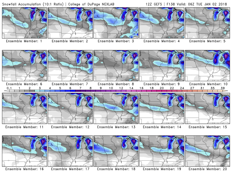
The latest GFS ensembles show the best snow coverage staying just north of our region. If one of these systems were to track a bit further south, then snow chances would increase. For now, the snow chances remain low.
.
Each one of these frames is one of the GFS ensemble members. Notice that band mainly to our norther.
.
.
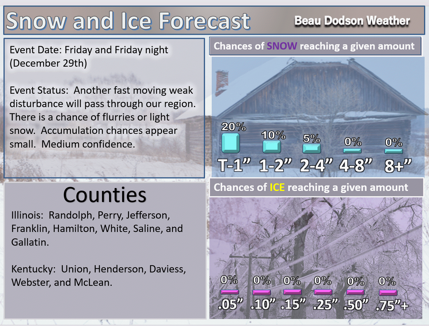
Here are the snow probabilities for Friday into Friday night. Weak system. Low potential. Medium confidence in the forecast.
.
.
Counties south of those listed above have smaller chances of accumulating snow.
The next system of interest will arrive Saturday afternoon into Sunday. Low confidence on this one, as well. Most of the models show little or no snow.
The trends on the GFS have been less and less snow. Does not look great for snow fans.
I will continue to monitor trends in the guidance.
Here is the probability map for Saturday into Sunday. Monitor updates for changes in the forecast.
.
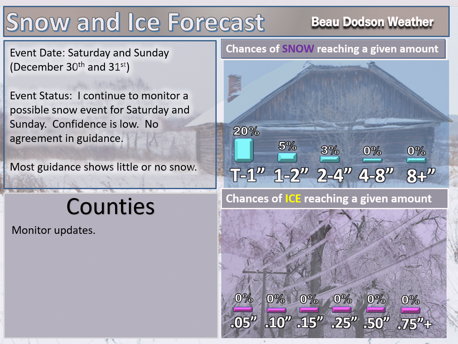
.
Beau’s Winter Weather Outlook
It is important to remember that this pattern is fluid. There is always going to be lower than normal confidence, during the winter months, for the forecast past day three or four.
.
.


We offer regional radars and local city radars – if a radar does not update then try another one. Occasional browsers need their cache cleared. You may also try restarting your browser. This will usually fix any problems.
During the winter you can track snow and ice by clicking the winterize button on the local city view interactive radars.
You may email me at beaudodson@usawx.com
Interactive Weather Radar Page. Choose the city nearest your location: Click this link
National interactive radar: Click this link.