

.
I have some question-and-answer threads over on the Facebook page. Link to those threads CLICK HERE
Or email me at beaudodsonweather@gmail.com
I will be participating in this year’s Dancing With The Stars in Paducah.
I am looking for donations and sponsorships.
You can buy a table at this link and/or donate (you don’t need to buy a table to donate).
More information at this link. CLICK HERE
.

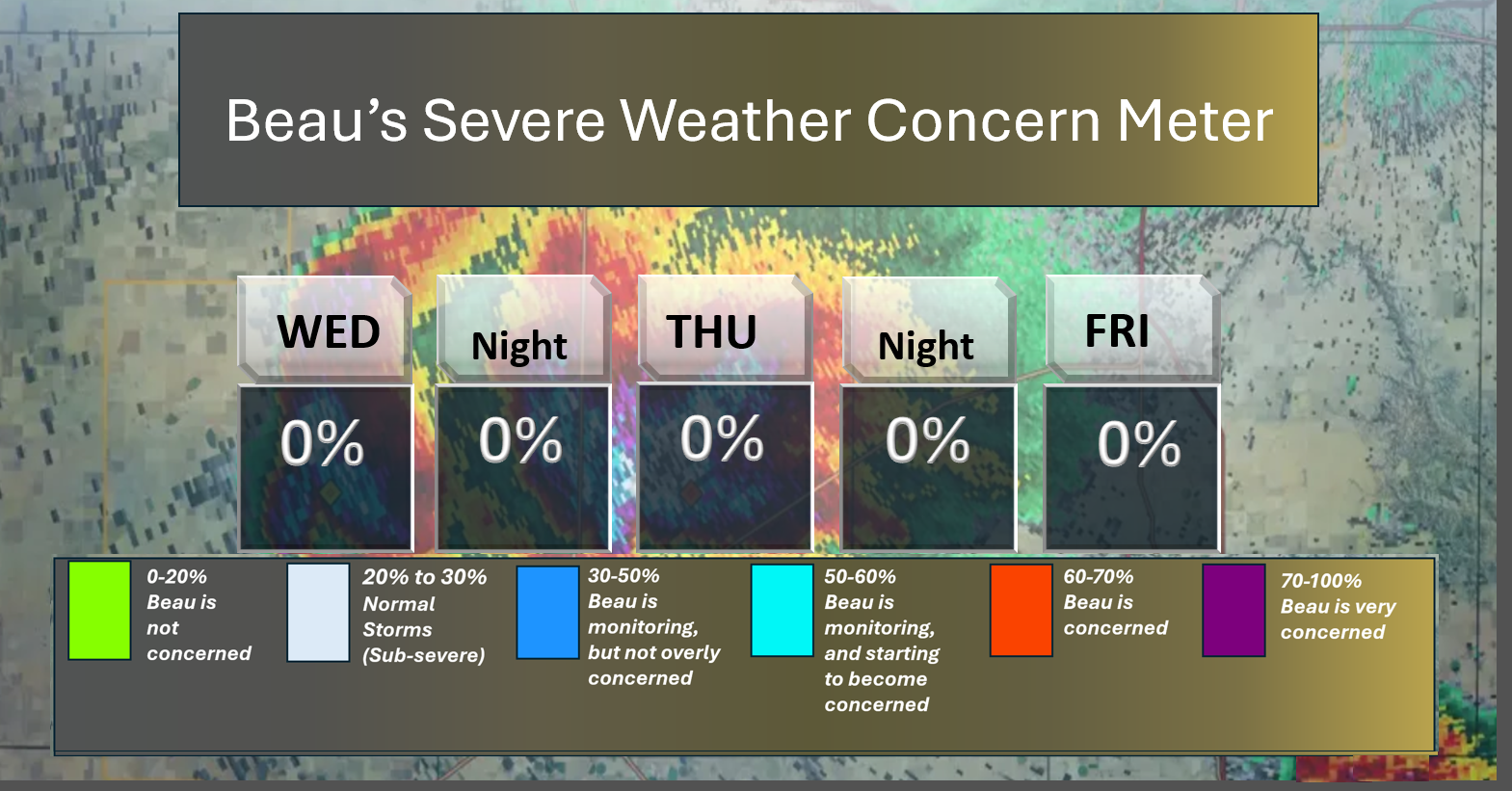
🌪️ Seven-Day Tornado Outlook ⛈️
February 11th through February 17th
Current risk: No concerns.
Current confidence level: High confidence.
Comments: Severe weather is not anticipated.
.

Seven-Day Hazardous Weather Outlook
1. Is lightning in the forecast? NOT AT THIS TIME.
2. Are organized/widespread severe thunderstorms in the forecast? NO.
..3. Is significant or widespread flash flooding in the forecast? NO.
4. Will non-thunderstorm winds top 40 mph? NO.
5. Will the temperature fall below 20 degrees? NO.
6. Is the wind chill forecast to drop below ten degrees? NO.
7. Is accumulating snow (one inch or more of snow) or ice in the forecast? NO.
.
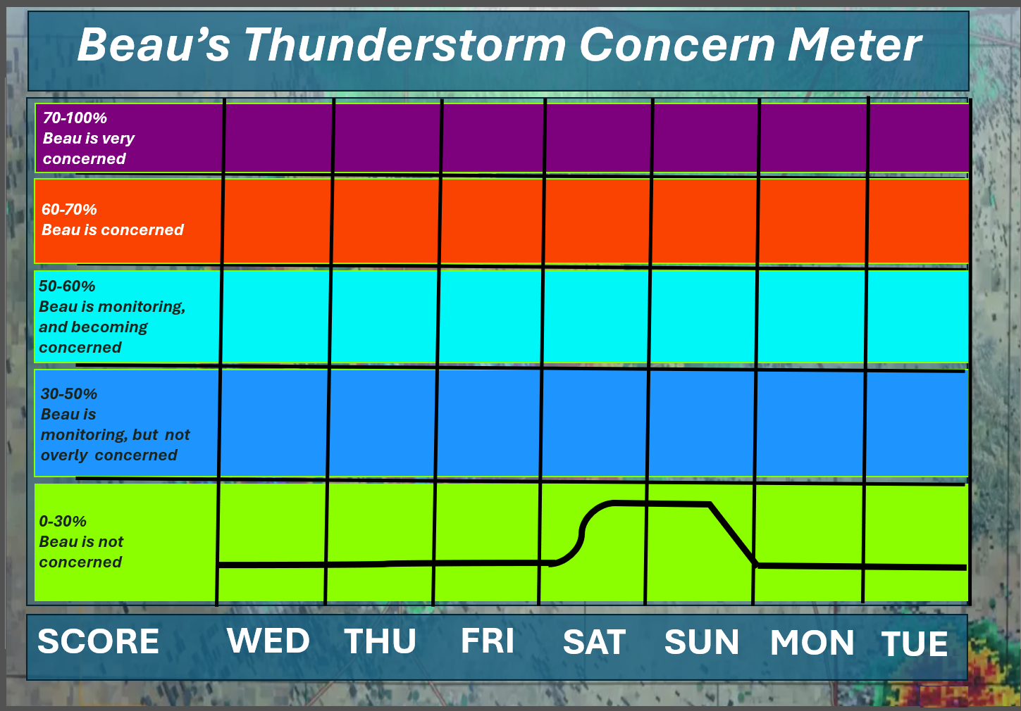
⛈️ Here is the short-range thunderstorm concern meter.
.
⛈️ Here is the extended thunderstorm concern meter.
.


.
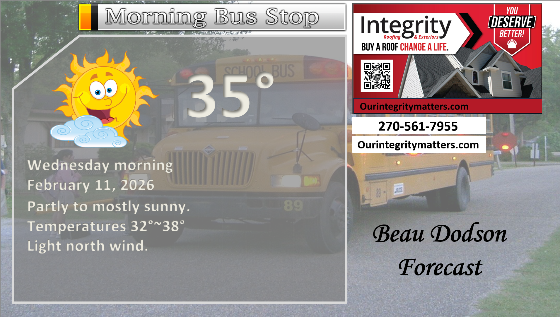
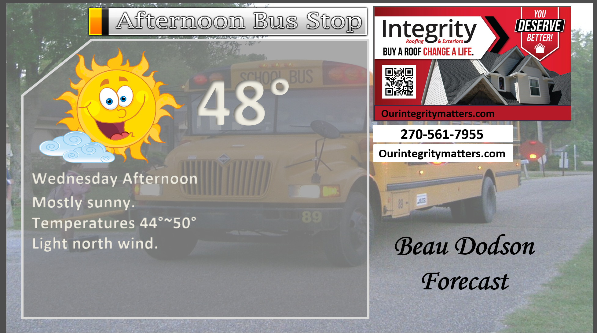
Here is your bus stop forecast
.
This afternoon
.


Forecast discussion
- Cooler today.
- Low-end rain chances on Friday night.
- Increasing rain chances this weekend, but questions remain on the totals.
- Peak rain chances will arrive on Saturday afternoon into Sunday morning.
.
 .
.
.
What is the primary weather concern?
No significant weather concerns through Friday evening.
A few clouds from time to time.
Rain chances will ramp up on Saturday and Sunday. There remain questions about rain totals.
.
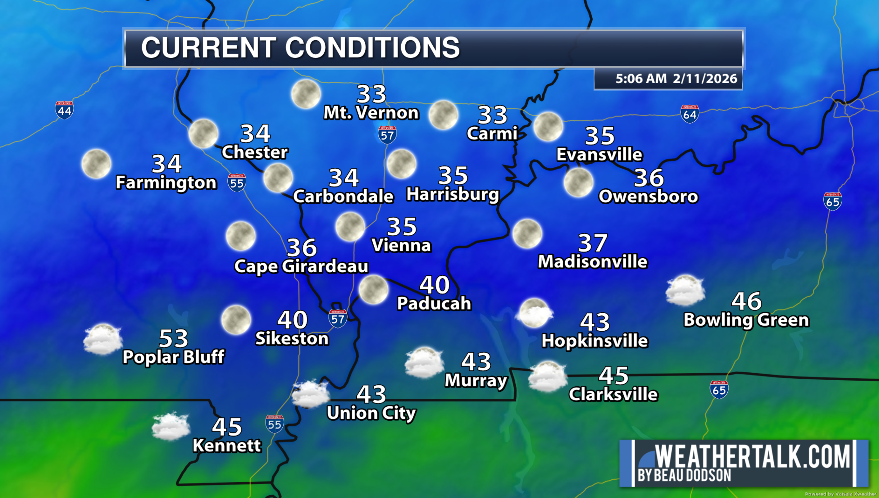
This morning through Friday evening
These were the 5 am temperatures.
A chilly morning, but not too bad for the middle of February.
.
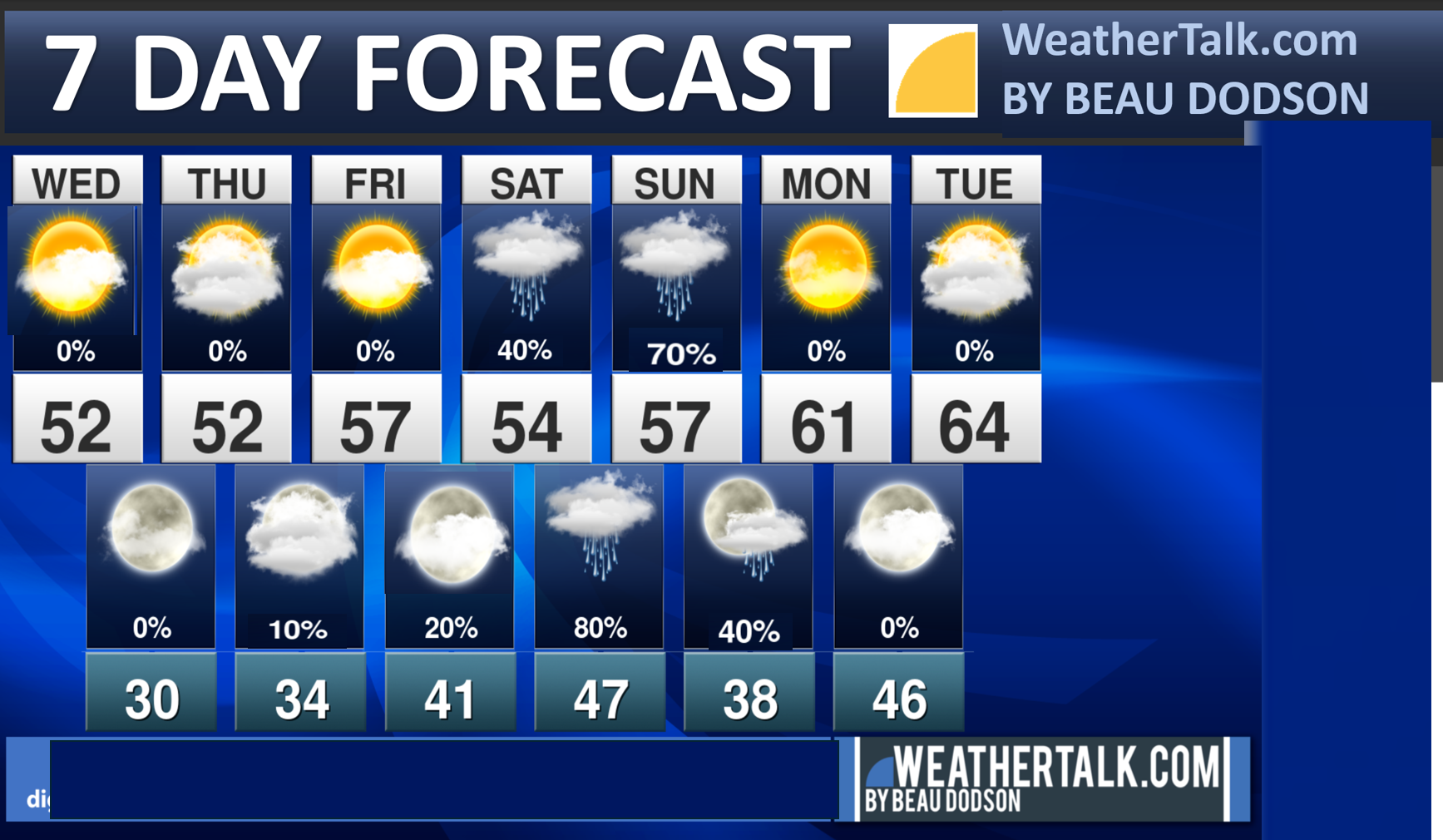
Seven-day outlook graphic.
See the video or graphics below for more details specific to your county. This is a broad-brush overview of the entire region.
.
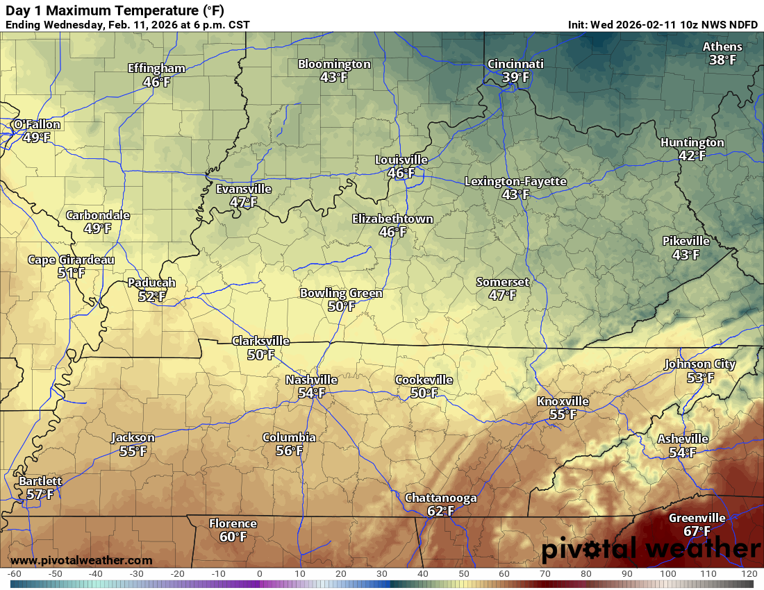
A cool day ahead of us.
Yesterday delivered some record high temperatures. In fact, some locations reached the mid-70s!
A band of showers moved across the region during the late afternoon and evening hours. Some brief downpours were reported.
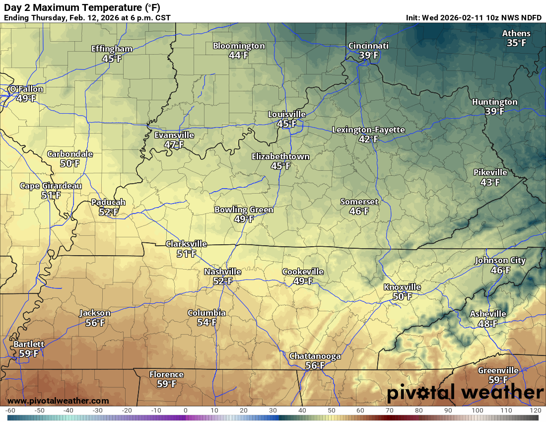
Today will be cooler than yesterday.
Today’s high temperatures.
.
Thursday’s high temperatures.
.
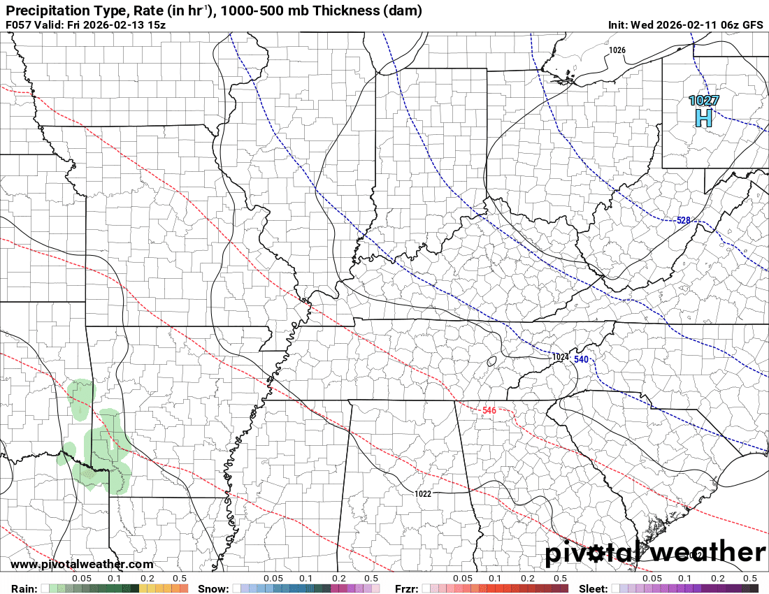
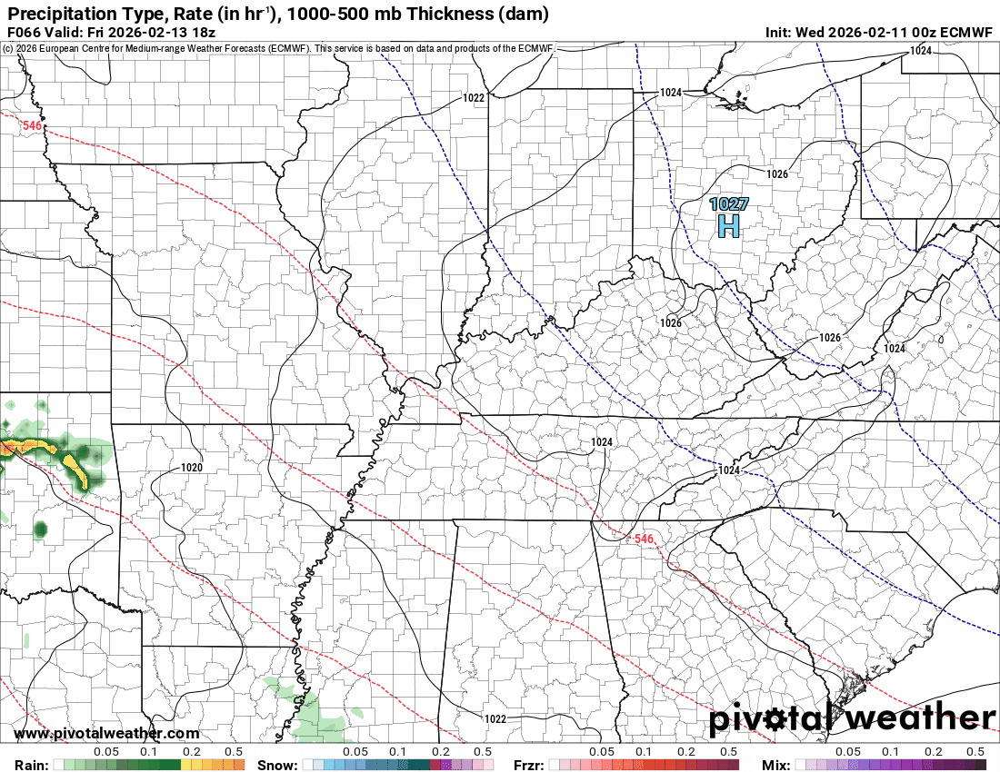
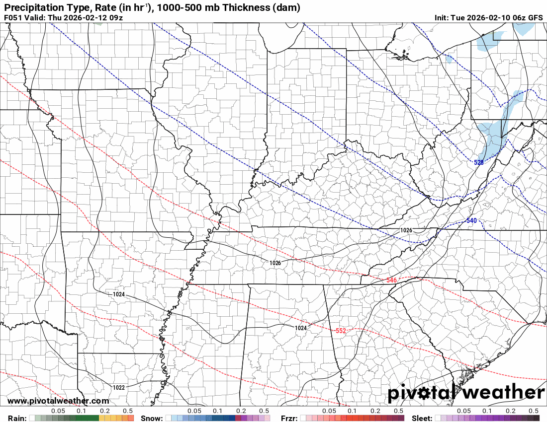
It will be dry today through Friday afternoon and evening.
Our next precipitation event will arrive this weekend. See the future-cast radars below.
It has slowed a bit, and I continue to monitor rain totals. The overall trend has been to reduce rainfall totals.
That said, small adjustments to the storm’s track will change the forecast rainfall totals.
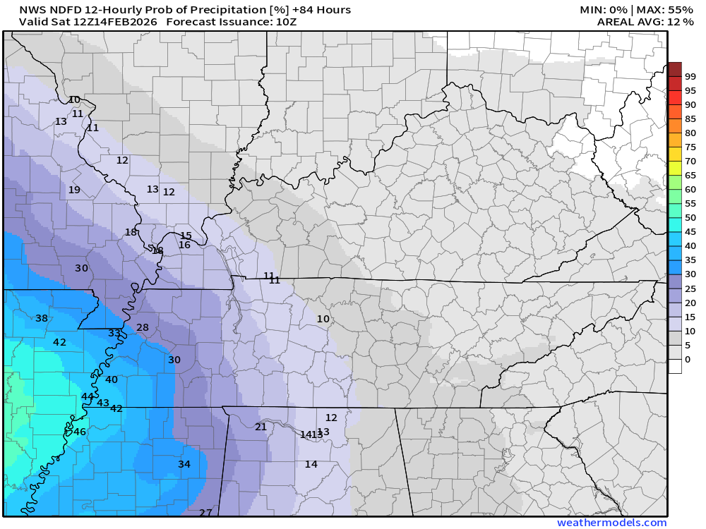
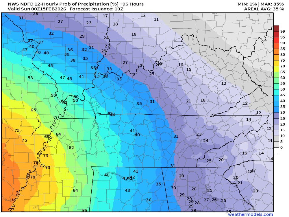
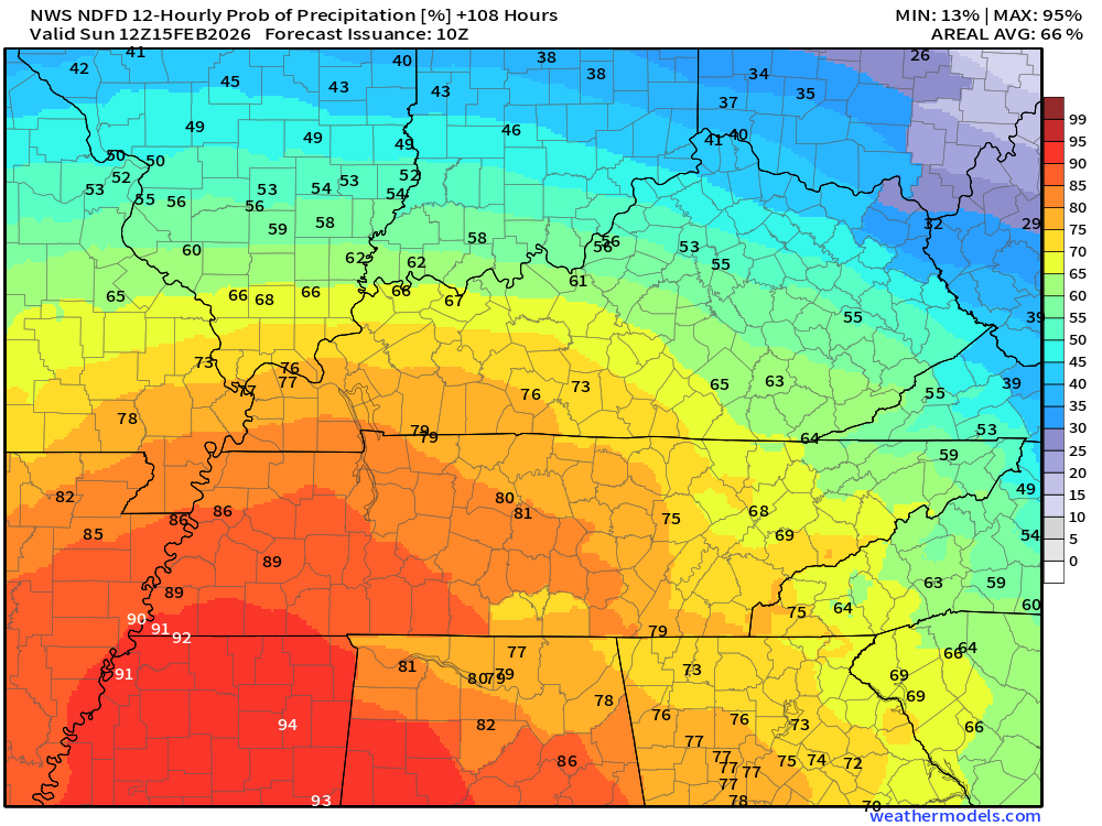
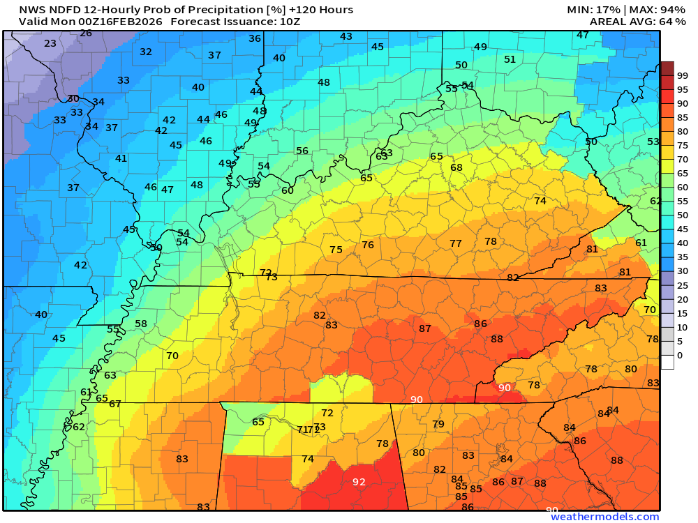
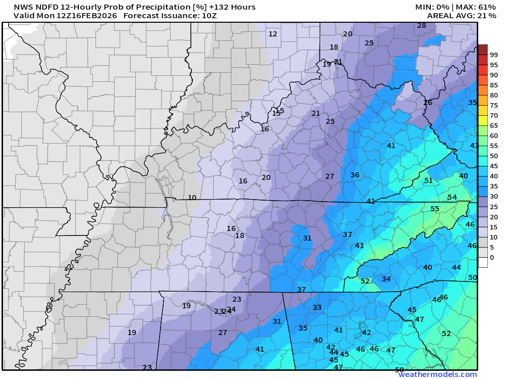
Let me show you the rainfall probabilities for the next rain event.
What is the % chance of rain?
This is for Friday night. A few showers are possible across mainly southeast Missouri. Mostly late at night.
Double-click on the two graphics to enlarge them.
.
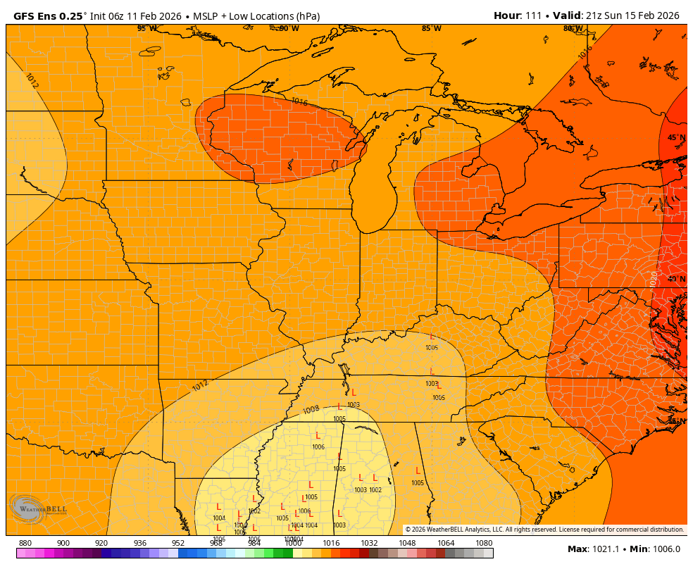
The models show varying intensities for the system.
Although the primary models differ, I can see the ensembles are converging on a storm track to our south.
That means the primary area of low pressure will track south of us.
That keeps us on the cool wet side of the system. Typically, in the winter months, this would be a snow track for our region.
We just don’t have enough cold air for a snow event.
Here are the GEFS model ensembles. The L’s are the area of low pressure.
.
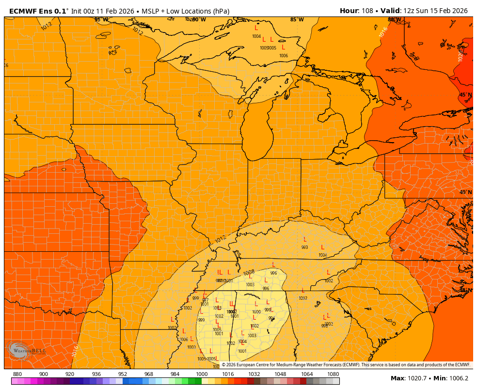
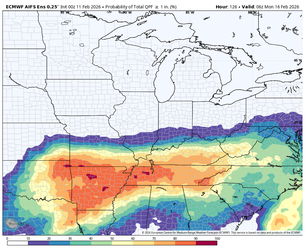
Here are the EC ensembles. A different model. Note that the L’s are clustered to our south.
It aligns with the GEFS ensembles.
.
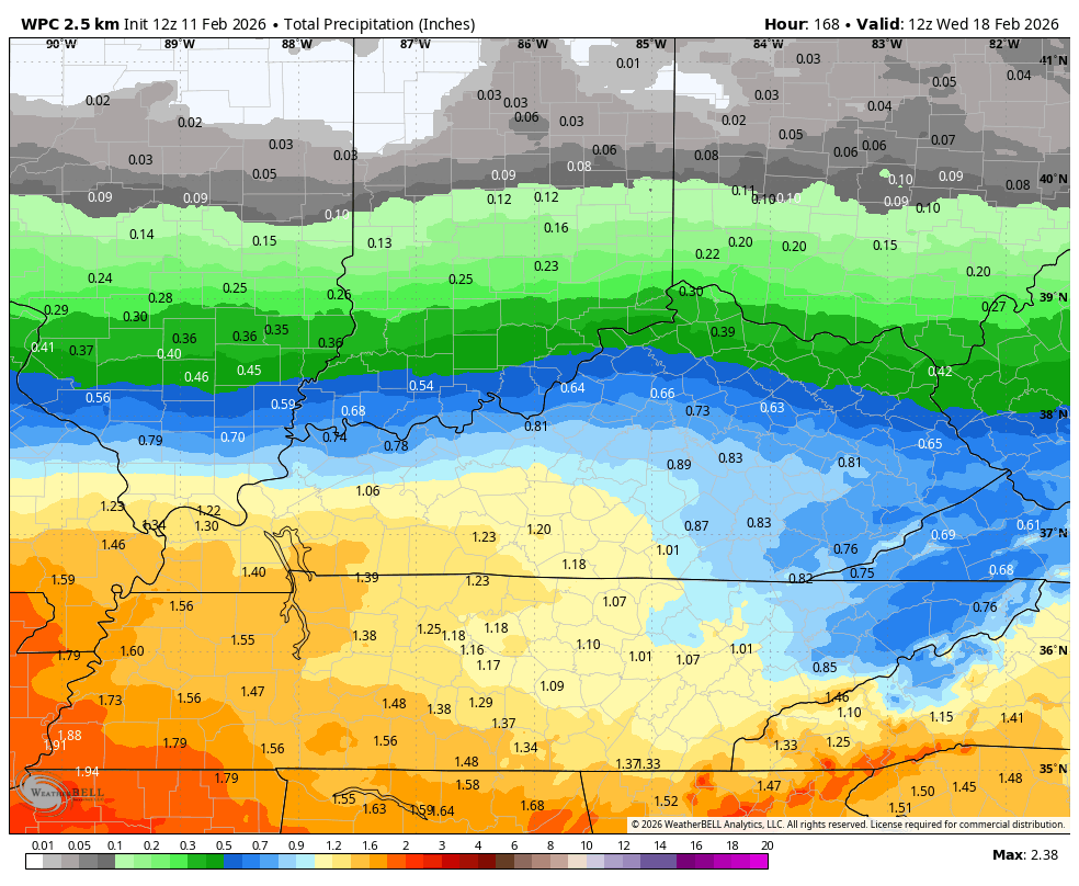
Let’s take a look at rainfall totals.
Let me show you the GEFS and EC ensembles.
What is the probability of one inch or more of rain?
GEFS
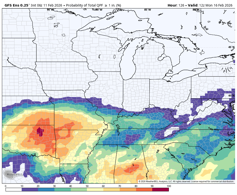
.
What about the EC ensembles?
Here is the probability of at least 1 inch of rain from Friday through Sunday.
.
That storm track would likely keep thunder out of our forecast this weekend.
Bottom line: rain chances will increase late Friday night into Sunday. Rain totals will need to be monitored. Adjustments are likely as confidence in the eventual storm track increases.
Peak rain chances will be Saturday into Sunday.
Double-click the graphic to enlarge it.
This is the latest rainfall outlook. There was a slight shift southward over the past 24 hours.
As you can see, the higher totals will be in my southern counties. Lighter totals north.
.
Data shows a couple more systems to monitor next week and the week after.
Perhaps we can pick up some much-needed rainfall.
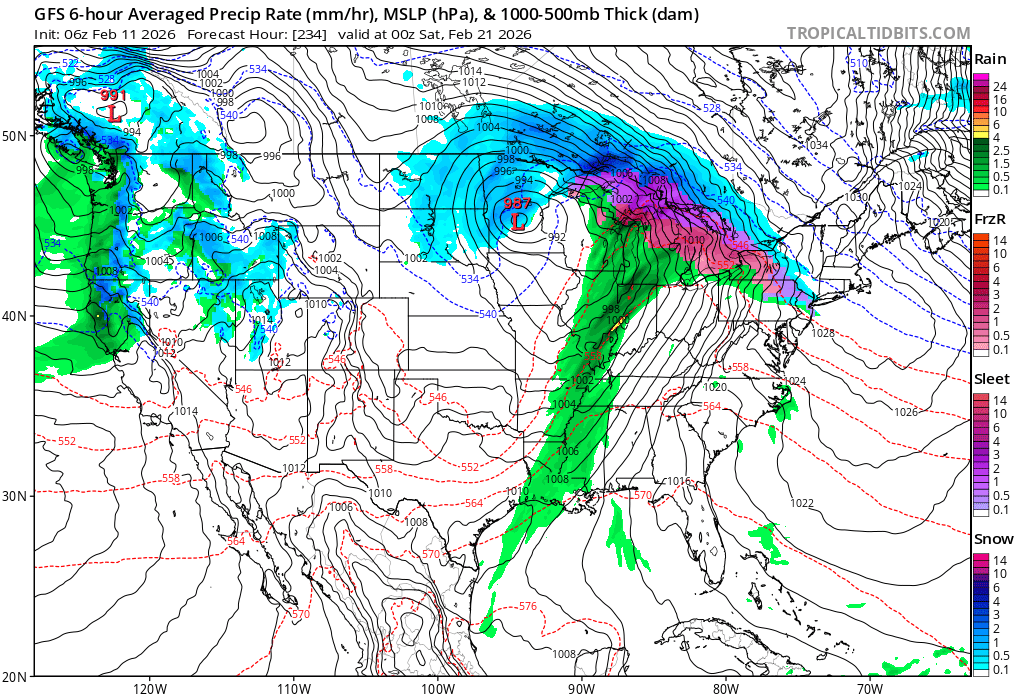
Here is the long-range GFS model.
It shows a system around Friday the 21st. A long way out. I will monitor trends.
.
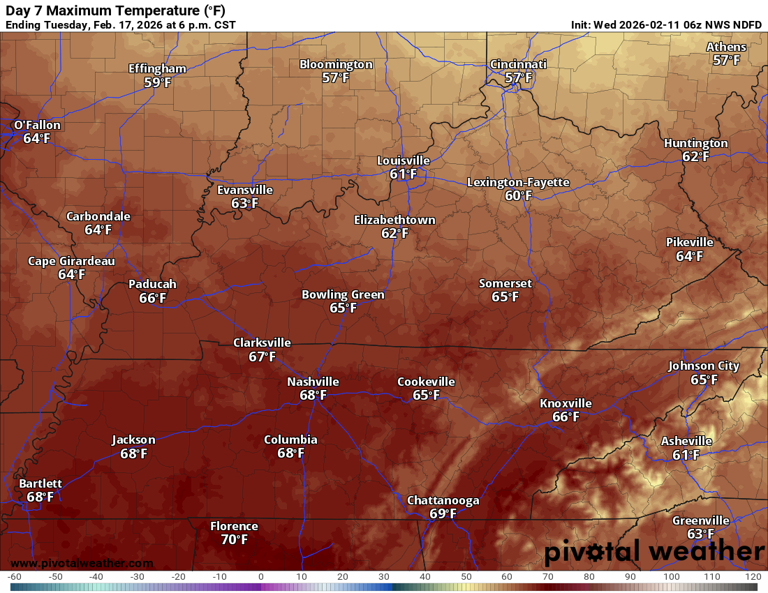
Temperatures will be warmer next week.
As a matter of fact, check out next Tuesday’s high temperatures. Let’s hope this holds. Nice.
.
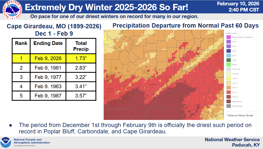
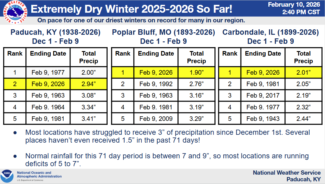
Speaking of much-needed rainfall.
It is extremely dry. Yes, we had some snow and ice, but that does not add up to much when it melts.
.

.
The timestamp (upper left) is in Zulu. 12z=6 am. 18z=12 pm. 00z=6 pm.
Double-click the animation to enlarge it.
Green is rain. Yellow is moderate rain. Orange and red indicate locally heavy rain.
Blue is snow.
GFS Model
Long range
This is the Tuesday PM system
.
The timestamp (upper left) is in Zulu. 12z=6 am. 18z=12 pm. 00z=6 pm.
Double-click the animation to enlarge it.
Green is rain. Yellow is moderate rain. Red is locally heavy rain. Blue is snow.
EC model
 .
.
..
.
Click here if you would like to return to the top of the page.
.Average high temperatures for this time of the year are around 46 degrees.
Average low temperatures for this time of the year are around 28 degrees.
Average precipitation during this time period ranges from 0.60″ to 0.90″
Six to Ten Day Outlook.
Blue is below average. Red is above average. The no color zone represents equal chances.
Average highs for this time of the year are in the lower 60s. Average lows for this time of the year are in the lower 40s.

Green is above average precipitation. Yellow and brown favors below average precipitation. Average precipitation for this time of the year is around one inch per week.

.

Average low temperatures for this time of the year are around 29 degrees.
Average precipitation during this time period ranges from 0.60″ to 0.90″
.
Eight to Fourteen Day Outlook.
Blue is below average. Red is above average. The no color zone represents equal chances.

Green is above average precipitation. Yellow and brown favors below average precipitation. Average precipitation for this time of the year is around one inch per week.

.
.
.
We have a new service to complement your www.weathertalk.com subscription. This does NOTreplace www.weathertalk.com It is simply another tool for you to receive severe weather information.
.
https://weathercallservices.com/beau-dodson-weather


Want to receive the daily forecast/other products on your Beau Dodson Weather app?
Did you know you have four options in your www.weathertalk.com account
You will then receive these via your Beau Dodson Weather app.
Just log into your www.weathertalk.com account
Click the NOTIFICATION SETTINGS TAB
Then, turn them on (green) and off (red)
🌪️ Number 1 is the most important one. Severe alerts, tornado alerts, and so on.
Number 2 is the daily video, blog, livestream alerts, and severe weather Facebook threads on severe days or winter storm days.
Number 3 is the daily forecast. I send that out every day during the afternoon hours. It is the seven-day forecast, hazardous weather outlook, fire outlook, and more.
Number 4 is to receive the daily video, blog, and other content on NON-severe weather days (every day without severe threats in other words)
GREEN IS ON
RED IS OFF

I am going to start going live during bigger severe weather events.
Check it out here https://www.youtube.com/user/beaudodson
Click the subscribe button (it’s a free subscription button), and it will alert you when I go live. I will also send out alerts to the app when I go live for an event.

.

Radars and Lightning Data
Interactive-city-view radars. Clickable watches and warnings.
https://wtalk.co/B3XHASFZ
Old legacy radar site (some of you like it better)
https://weatherobservatory.com/weather-radar.htm
If the radar is not updating then try another one. If a radar does not appear to be refreshing then hit Ctrl F5. You may also try restarting your browser.
Backup radar site in case the above one is not working.
https://weathertalk.com/morani
Regional Radar
https://imagery.weathertalk.com/prx/RadarLoop.mp4
** NEW ** Zoom radar with chaser tracking abilities!
ZoomRadar
If the radar is not working, then email me: Email me at beaudodson@usawx.com
.
We do have some sponsors! Check them out.
Roof damage from recent storms? Link – Click here
INTEGRITY ROOFING AND EXTERIORS!
⛈️ Roof or gutter damage from recent storms? Today’s weather is sponsored by Integrity Roofing. Check out their website at this link https://www.ourintegritymatters.com/

![]()
![]()
![]()
Make sure you have three to five ways of receiving your severe weather information.
Weather Talk is one of those ways! Now, I have another product for you and your family.

.
Want to add more products to your Beau Dodson Weather App?
Receive daily videos, weather blog updates on normal weather days and severe weather and winter storm days, your county by county weather forecast, and more!
Here is how to do add those additional products to your app notification settings!
Here is a video on how to update your Beau Dodson Weather payment.
The app is for subscribers. Subscribe at www.weathertalk.com/welcome then go to your app store and search for WeatherTalk
Subscribers, PLEASE USE THE APP. ATT and Verizon are not reliable during severe weather. They are delaying text messages.
The app is under WeatherTalk in the app store.

Apple users click here

Android users click here
.
Radars and Lightning Data
Interactive-city-view radars. Clickable watches and warnings.
https://wtalk.co/B3XHASFZ
Old legacy radar site (some of you like it better)
https://weatherobservatory.com/weather-radar.htm
If the radar is not updating then try another one. If a radar does not appear to be refreshing then hit Ctrl F5. You may also try restarting your browser.
Backup radar site in case the above one is not working.
https://weathertalk.com/morani
Regional Radar
https://imagery.weathertalk.com/prx/RadarLoop.mp4
** NEW ** Zoom radar with chaser tracking abilities!
ZoomRadar
Lightning Data (zoom in and out of your local area)
https://wtalk.co/WJ3SN5UZ
Not working? Email me at beaudodson@usawx.com
National map of weather watches and warnings. Click here.
Storm Prediction Center. Click here.
Weather Prediction Center. Click here.
.

Live lightning data: Click here.
Real time lightning data (another one) https://map.blitzortung.org/#5.02/37.95/-86.99
Our new Zoom radar with storm chases
.
.

Interactive GOES R satellite. Track clouds. Click here.
GOES 16 slider tool. Click here.
College of DuPage satellites. Click here
.

Here are the latest local river stage forecast numbers Click Here.
Here are the latest lake stage forecast numbers for Kentucky Lake and Lake Barkley Click Here.
.
.
Find Beau on Facebook! Click the banner.


 .
.