

.
I have some question-and-answer threads over on the Facebook page. Link to those threads CLICK HERE
Or email me at beaudodsonweather@gmail.com
..

🌪️ Seven-Day Tornado Outlook ⛈️
December 12th through December 18th.
Current risk: NONE
Current confidence level: High confidence.
Comments:
.

Seven-Day Hazardous Weather Outlook
1. Is lightning in the forecast? NO.
2. Are organized/widespread severe thunderstorms in the forecast? NO.
4. Will non-thunderstorm winds top 40 mph? NO.
5. Will the temperature fall below 20 degrees? YES. A slight chance on Friday night. A high chance on Saturday and Sunday night.
6. Is the wind chill forecast to drop below ten degrees? YES. Saturday night into Monday morning. At times, wind chill values could dip below zero.
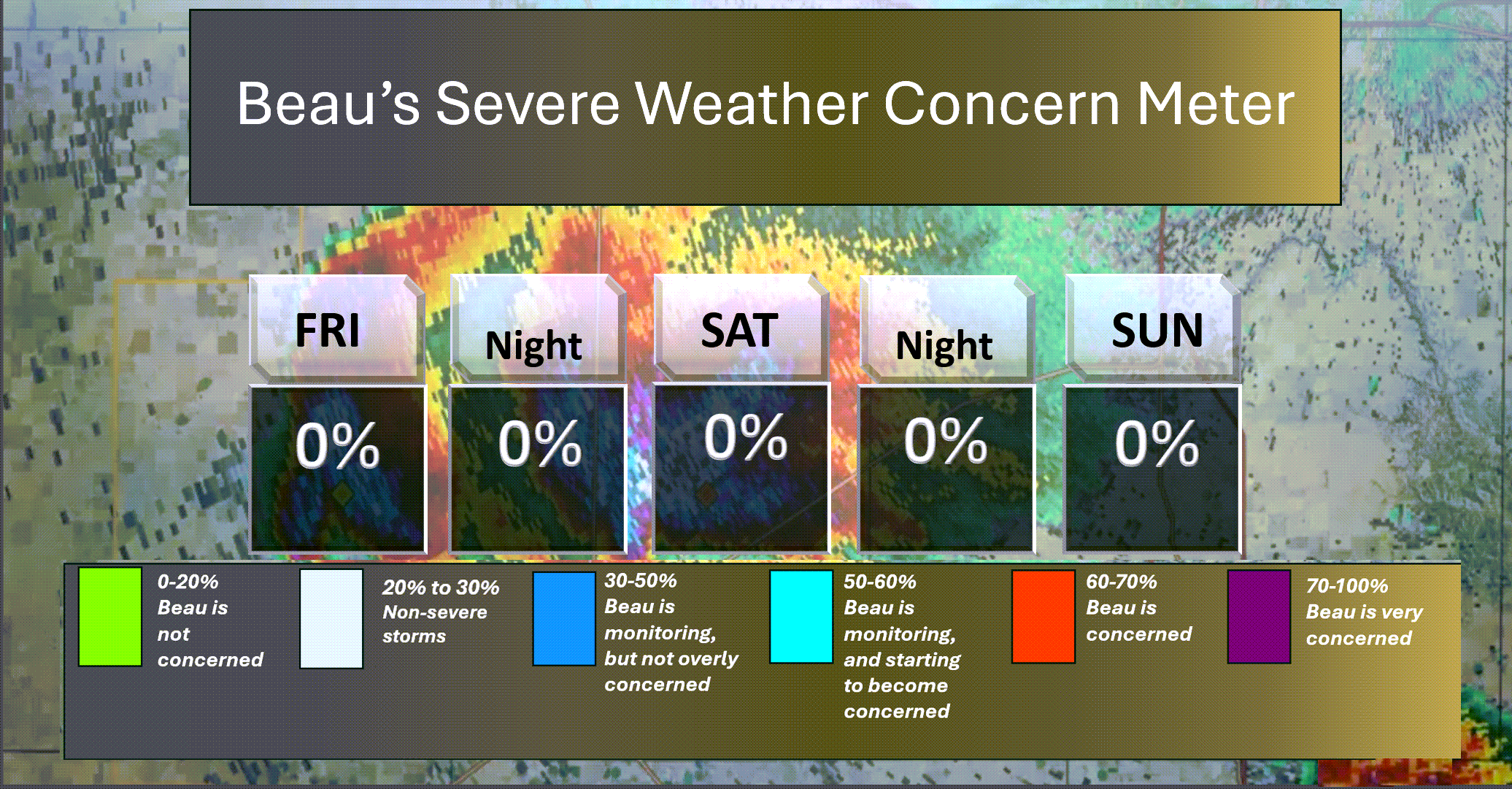
Here is the short-range thunderstorm concern meter.
.
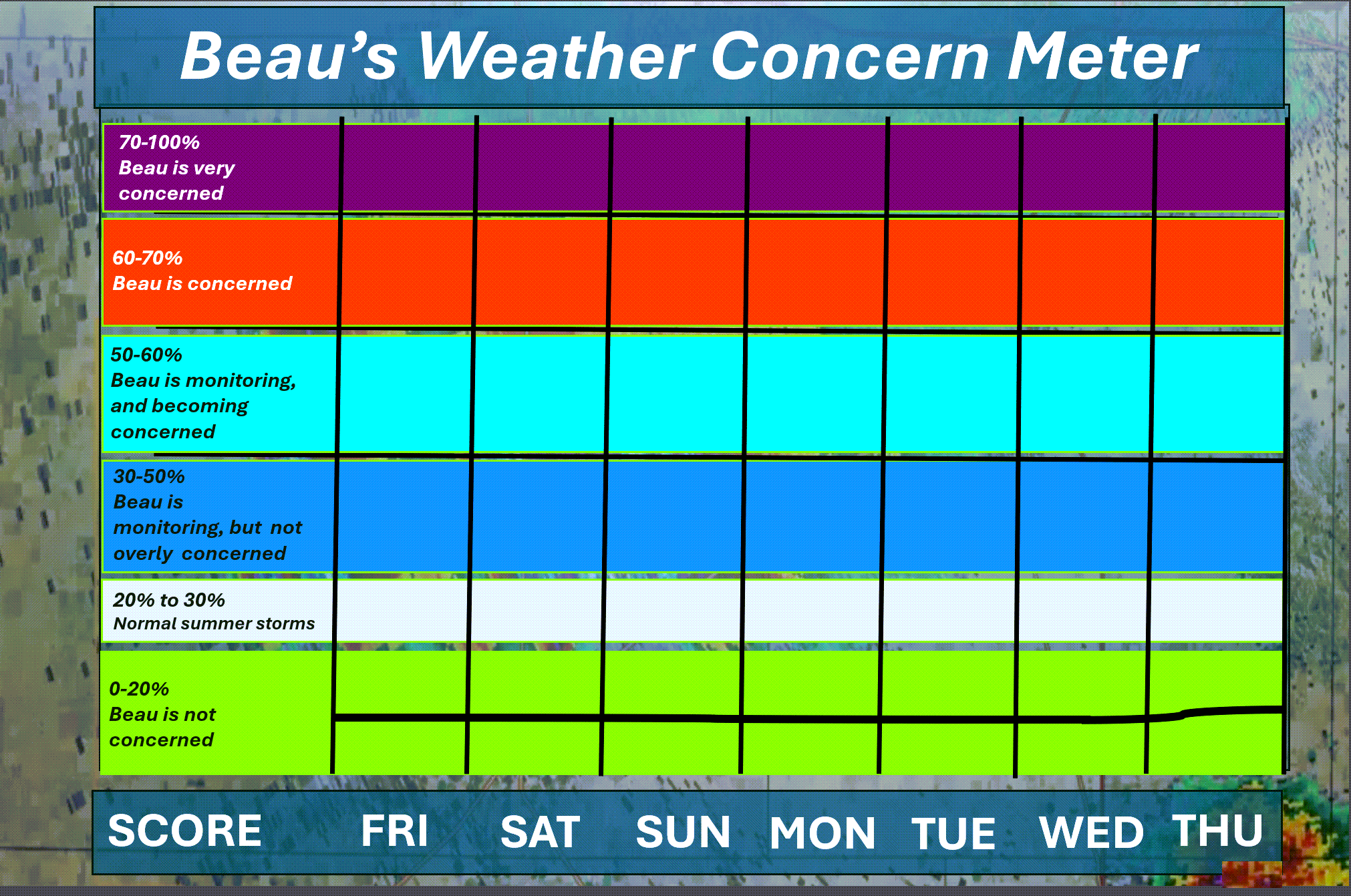
Here is the extended concern meter.
No severe weather concerns.
.
A quick forecast glance. Your 48-hour forecast Graphics


.
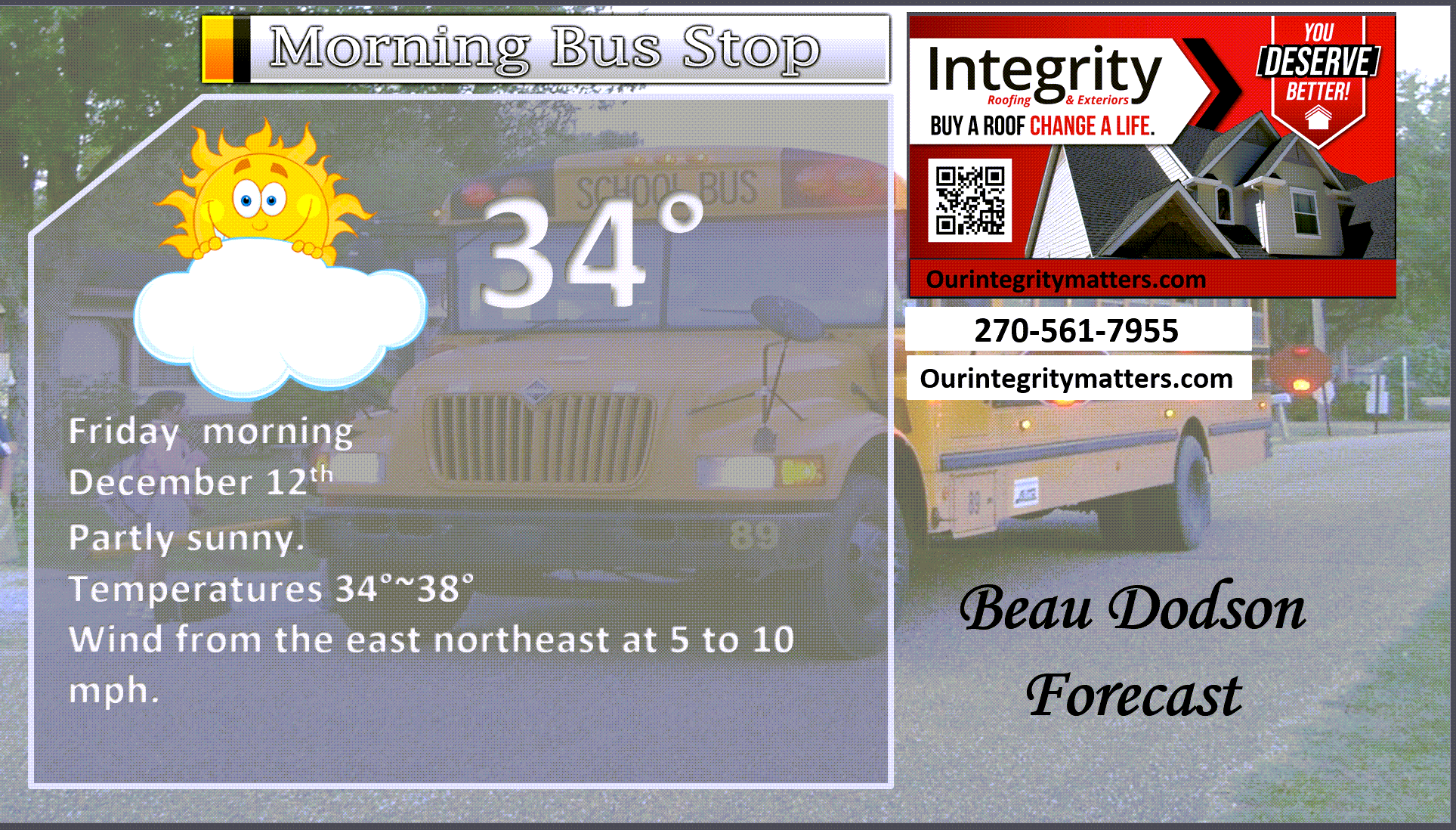
Here is your bus stop forecast
.
This afternoon

.


Forecast discussion
- A cool day ahead of us.
- A cold weekend ahead of us. The coldest night will be Saturday night/Sunday morning and Sunday night/Monday morning.
- A few snow showers are possible on Saturday afternoon and evening.
- Monitoring a warming trend this coming Wednesday and Thursday. That warming trend may linger into the following week.
- For now, Christmas Eve and Christmas Day are trending warmer than average with perhaps some showers. Medium confidence.
.
 .
.
.
What is the primary weather concern?
The primary concern will be bitterly cold temperatures Saturday night into Monday morning.
Temperatures will dip into the single digits and teens both Saturday and Sunday night. Wind chill values will dip below zero from Saturday night into Monday morning.
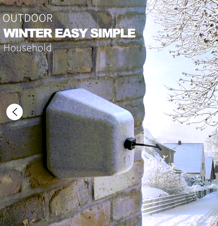
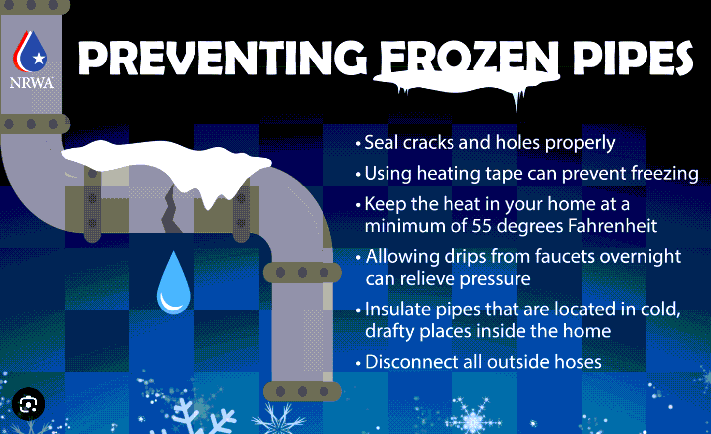
Unhook your outdoor water hose. Then, protect the exposed nozzle with something like this or other.
.
Protect exposed pipes.
.
Seven-day outlook graphic.
See the video for more details specific to your county. This is a broad-brushed outlook for the entire region.

.
Today through Sunday
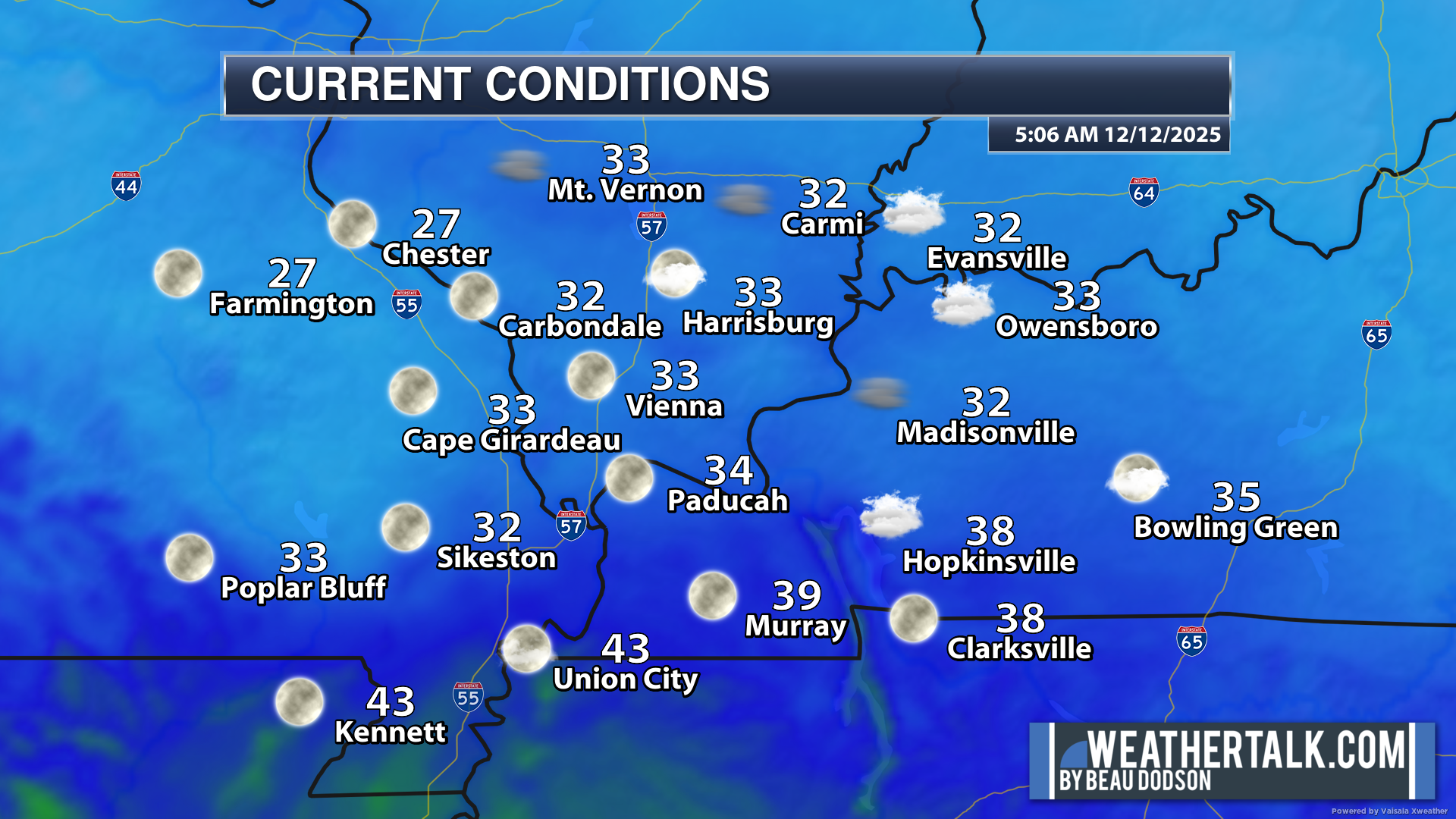
Good morning, everyone.
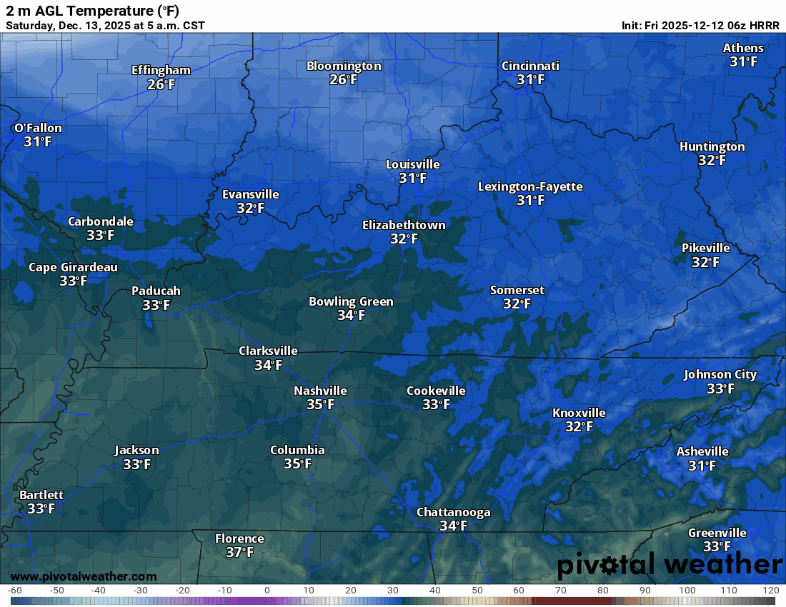
We are waking up to cool temperatures.
5 AM temperatures
.
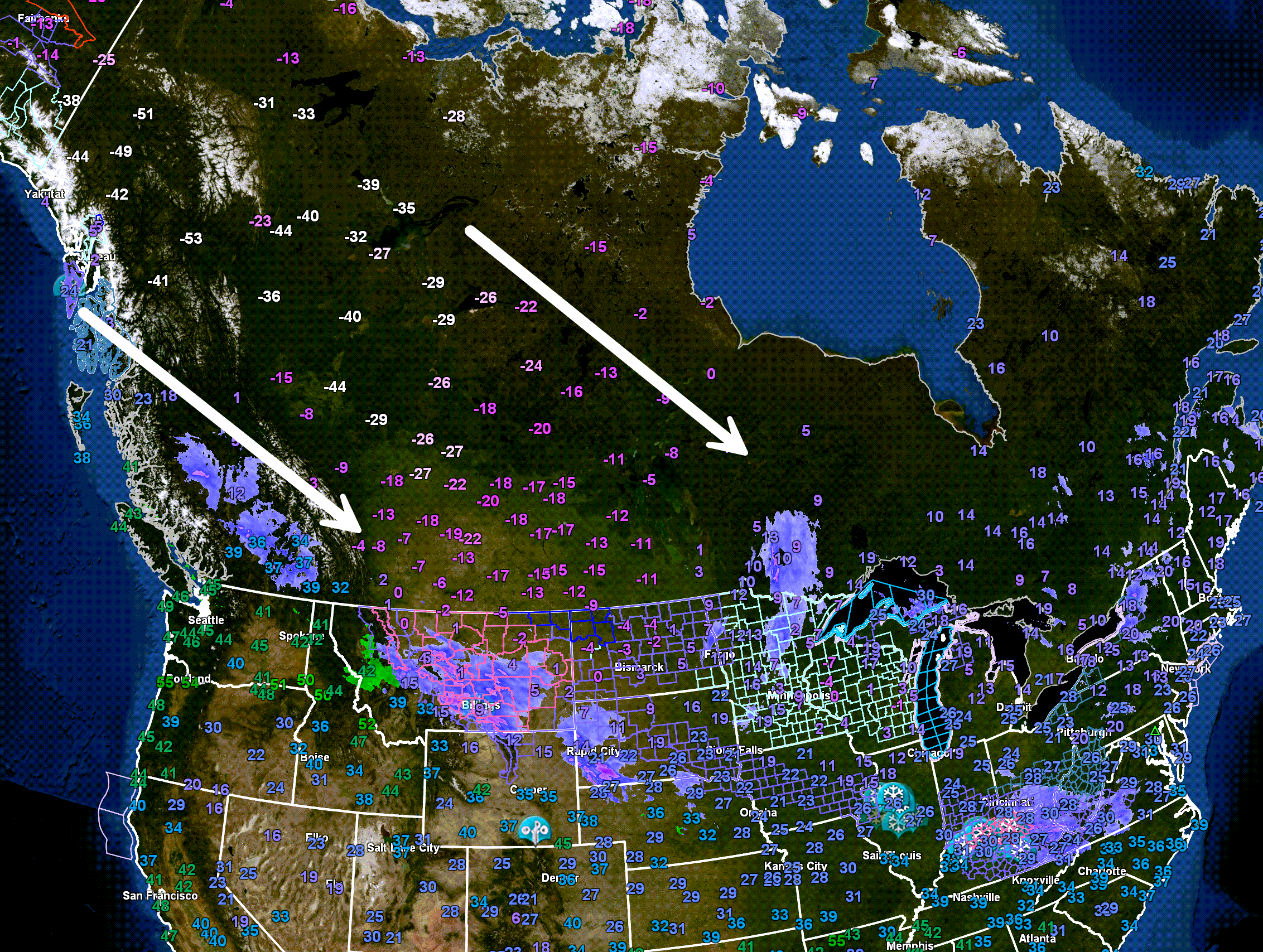
Once again, let’s check in on the cold air that is headed our way!
Yes, some locations in Canada are 50 below zero! Wind chill values are in the -60s. Incredibly cold.
This is the source region for our weekend cold snap. Thankfully, it won’t be THAT cold here.
Temperatures here will likely dip into the single digits this weekend (for most areas). That is quite cold, given the lack of a significant snowpack. Typically, that is the kind of cold we see with snow on the ground!
Double-click the image to enlarge it.
.
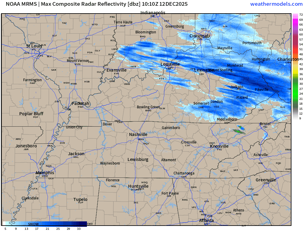
We did have some snow overnight across portions of southeast Illinois and northwest Kentucky. Some areas picked up a solid dusting of snow. Portions of southwest Indiana received a bit more.
I sent out a special weather statement yesterday for the counties impacted. Letting them know they might see some light accumulation.
You can see the snow moving away from our region on this 5:30 AM radar animation.
.
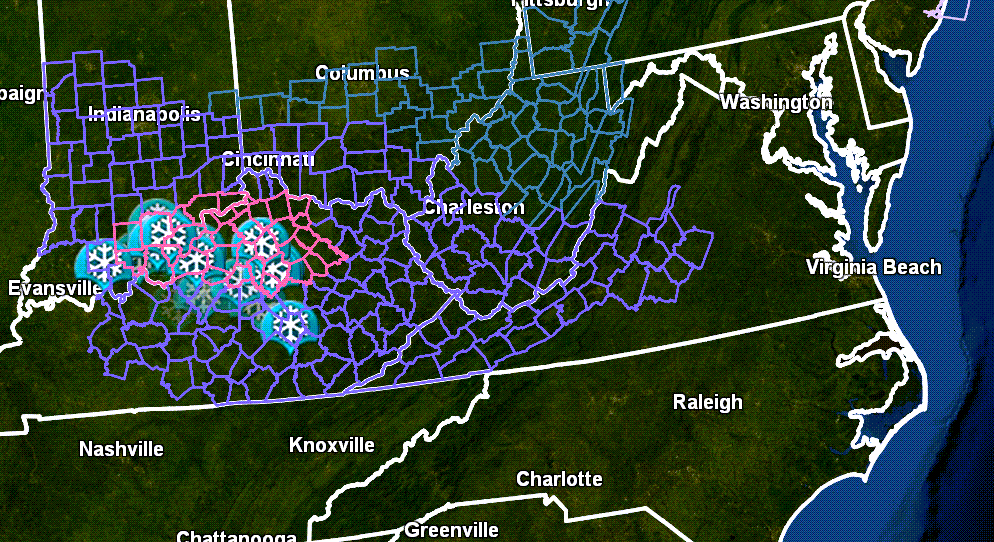
Check out the winter storm warnings and winter weather advisories on this morning’s weather map.
This is the system moving away from our region. That pink zone is a winter storm warning across portions of Indiana and Kentucky!
.
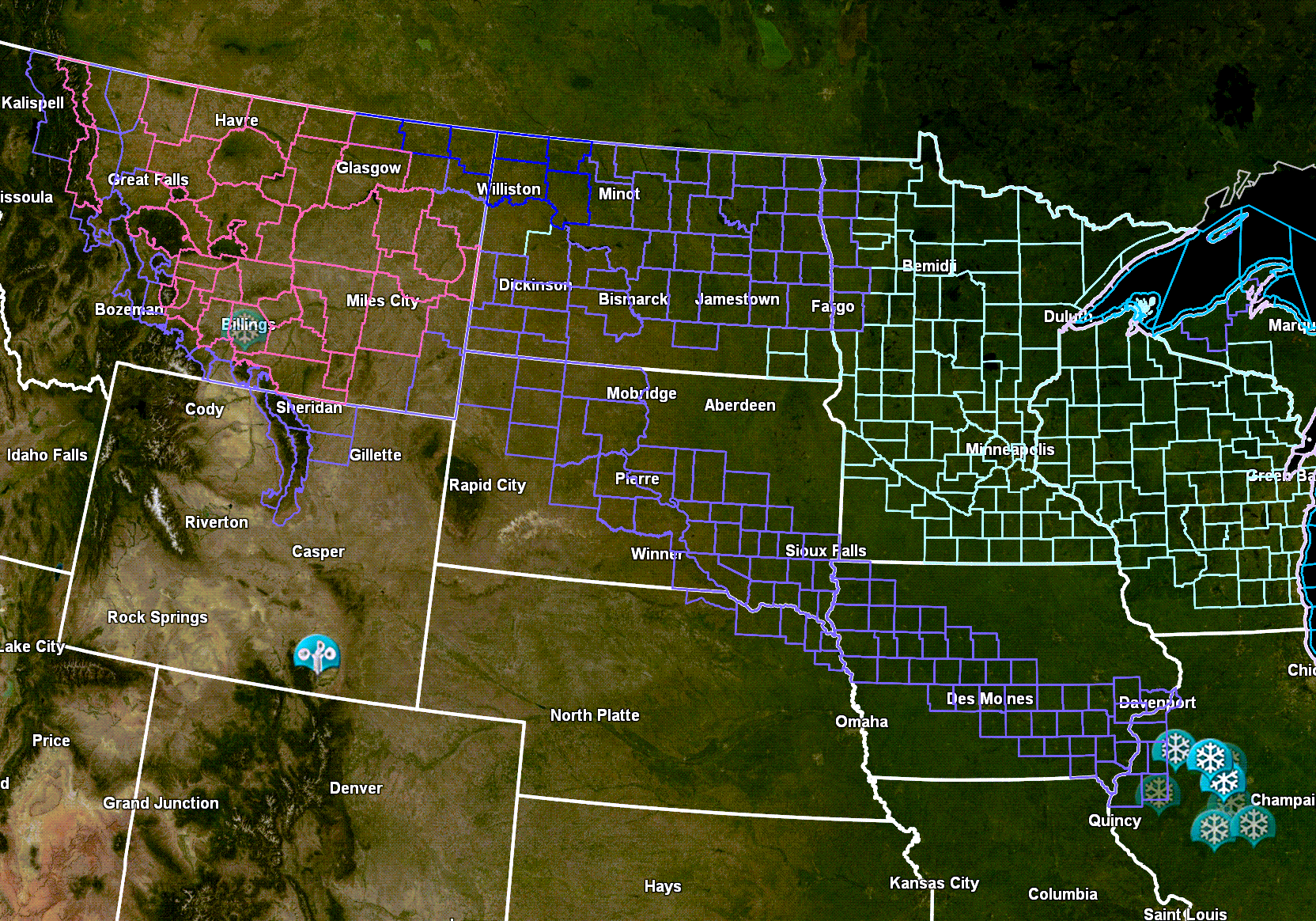
You can also see the next system taking shape over the northern United States. A long line of advisories into the Midwest. That is the snow that will race southeast tonight and tomorrow. This could clip my northern counties.
Any snow that falls in our region will be light. A dusting or so, at most. Most of the data weakens the band of snow as it moves east southeast into southern Illinois and western Kentucky.
No winter weather advisories in our local area.
.
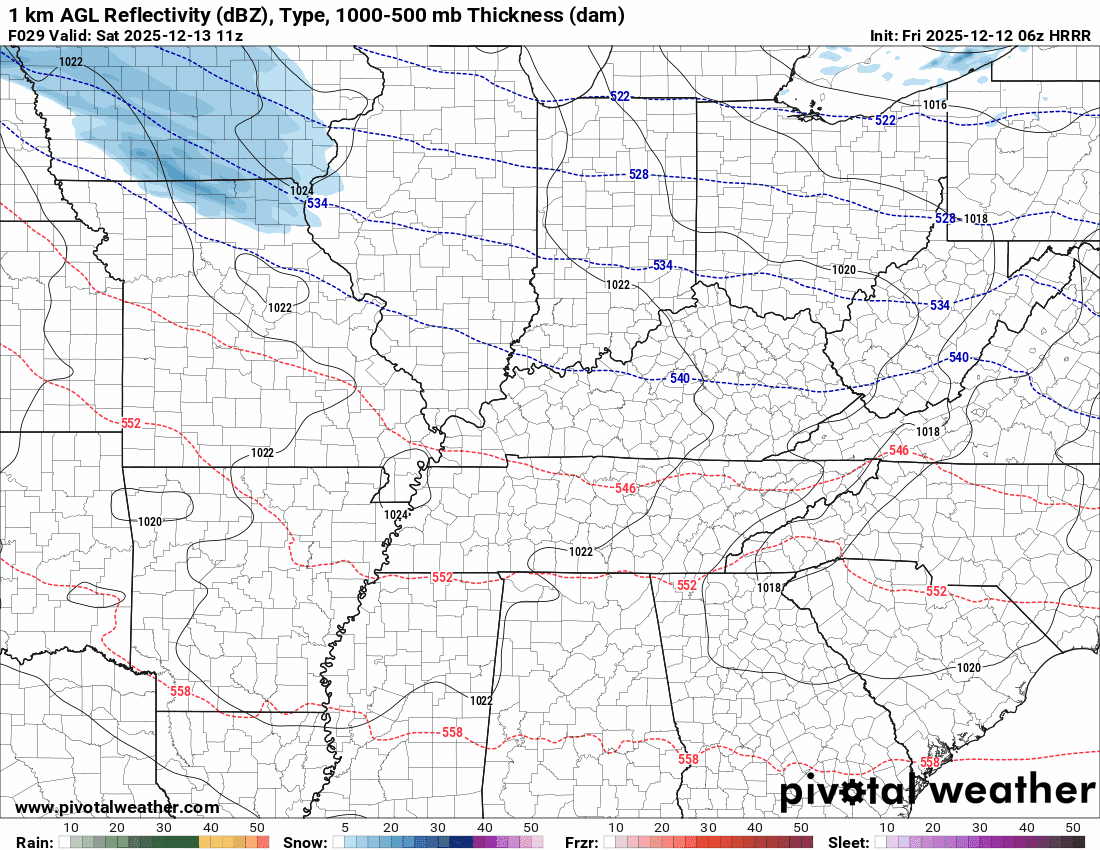
This will be a clipper-type system that will race southeast over the coming 24 to 36 hours.
You can see that band of snow weakening on this model animation. This is for Saturday afternoon and evening.
I can’t rule out flurries, just about anywhere in the region on Saturday afternoon and night. The chances are a bit higher, however, over southern Illinois and western Kentucky. Again, any accumulation would be light.
.
Temperatures will turn colder on Saturday afternoon and night. They may even fall during the afternoon hours (esp over our northern counties).
Here is the temperature animation. Watch the cold air arrive from north to south.
Double-click the animation to enlarge it.
.
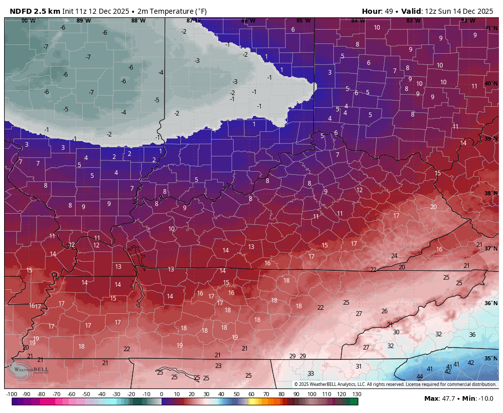
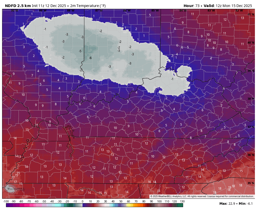
Bitterly cold air will be with us from Saturday PM into Monday.
Sunday morning and Monday morning will be bitterly cold.
Sunday morning lows
Double click to enlarge
Monday morning lows
Double click to enlarge
.
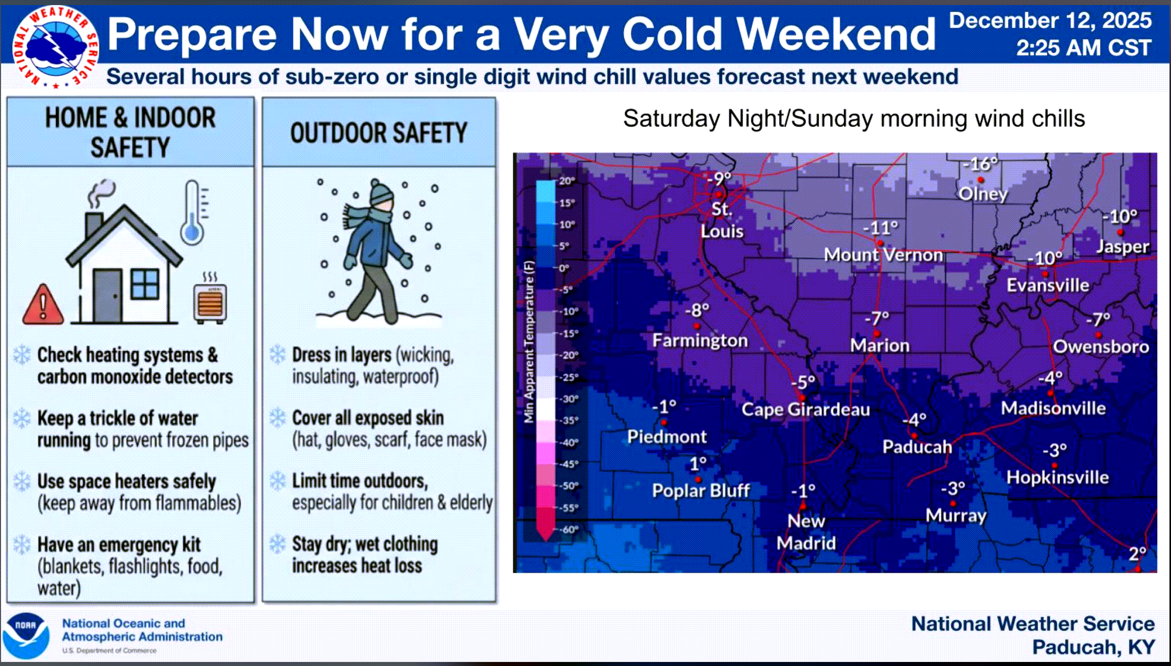
Keep in mind, wind chill values will be even colder.
Here are two graphics from the Paducah, Kentucky, NWS
Wind chill values Saturday night/Sunday morning. Brrr brrr brrr
.
Double-click this image to enlarge it. Here are some towns near your location (highs and lows)
.
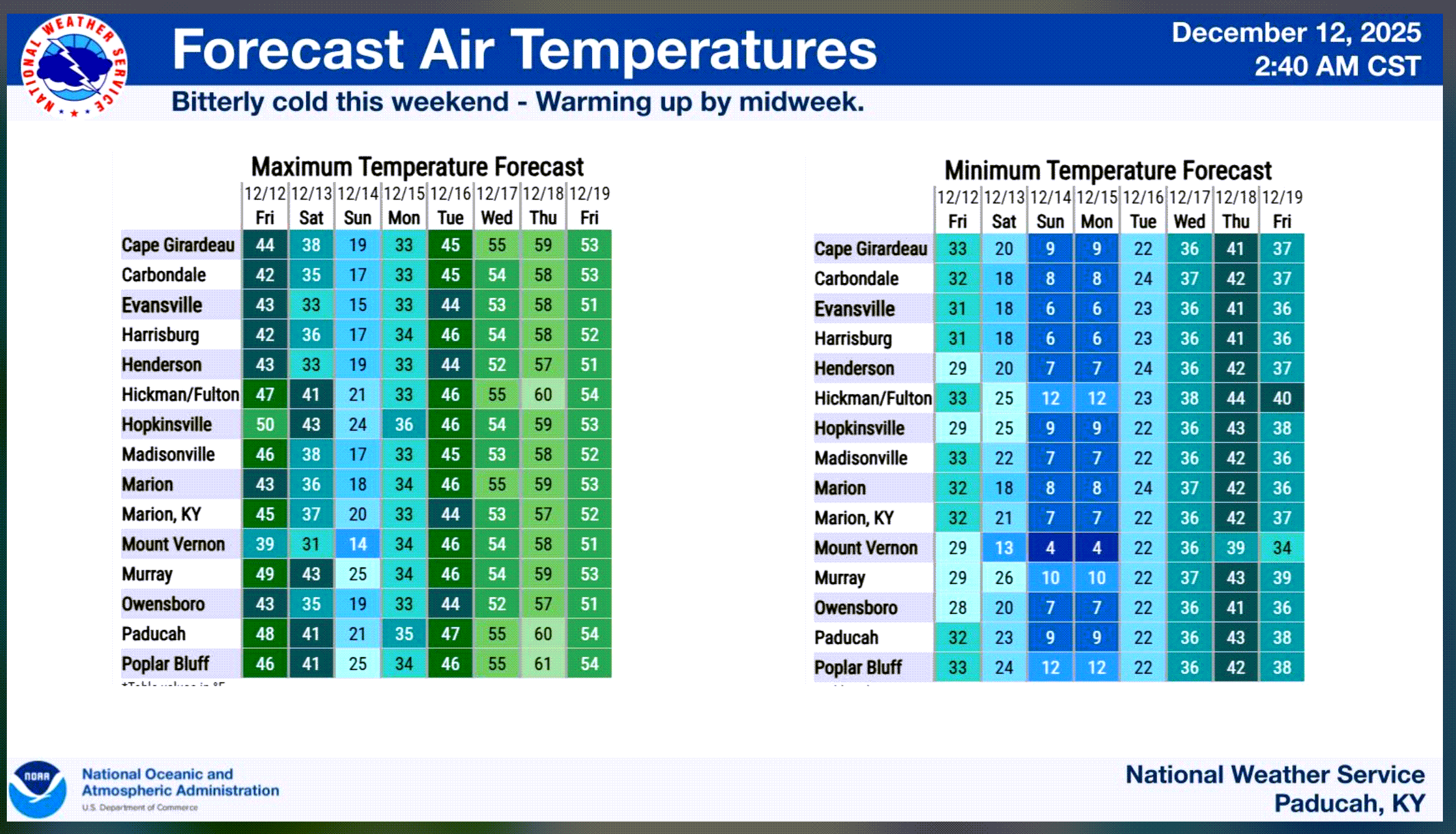
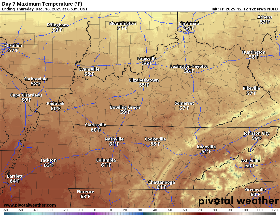
The good news is that by Wednesday and Thursday, temperatures will be warmer. This cold snap won’t last long.
Wednesday highs
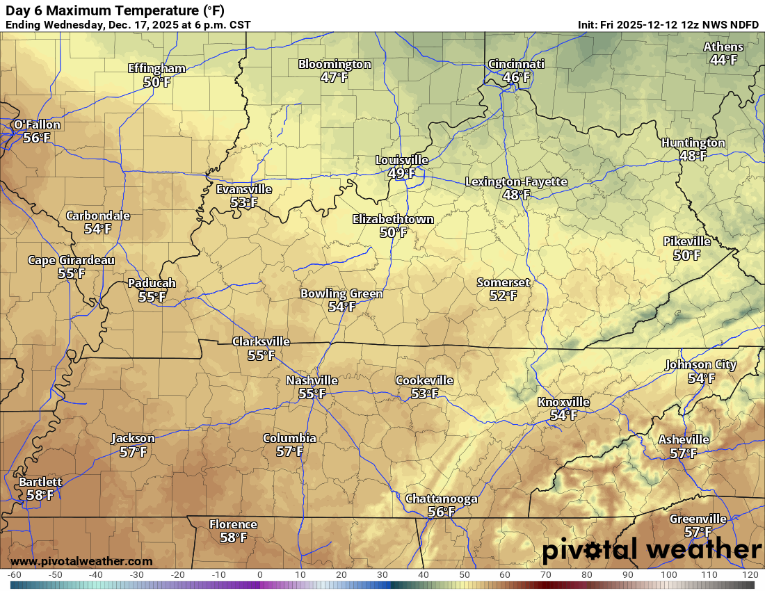
Thursday highs
.
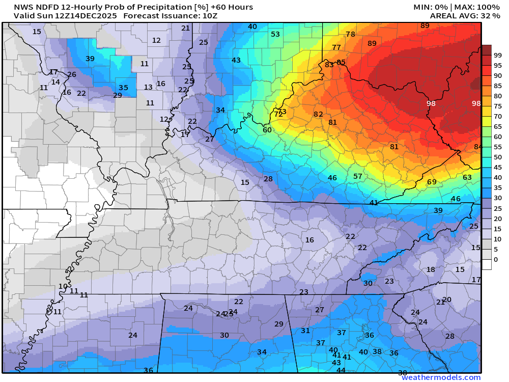
Let me show you the precipitation probabilities with our fast-moving clipper System (tomorrow’s system).
As mentioned above, we may have some snow showers on Saturday and Saturday night. Mainly over our northern counties.
What is the % chance of precipitation?
This is the official NOAA forecast. I could see those snow showers extending a bit farther south and east, as well. So, some adjustments are possible in this graphic.
I have chances around 30% across mainly southern Illinois and western Kentucky. A thin band of snow showers as the front moves through.
Saturday 6 AM to Saturday 6 PM

.
Saturday 6 PM to Sunday 6 AM
The good news is that a warming trend is showing up in the charts. That could mean a mild Christmas. If everything comes together as planned.
There are a few models that are still hinting at colder weather around Christmas, but they are the outliers.
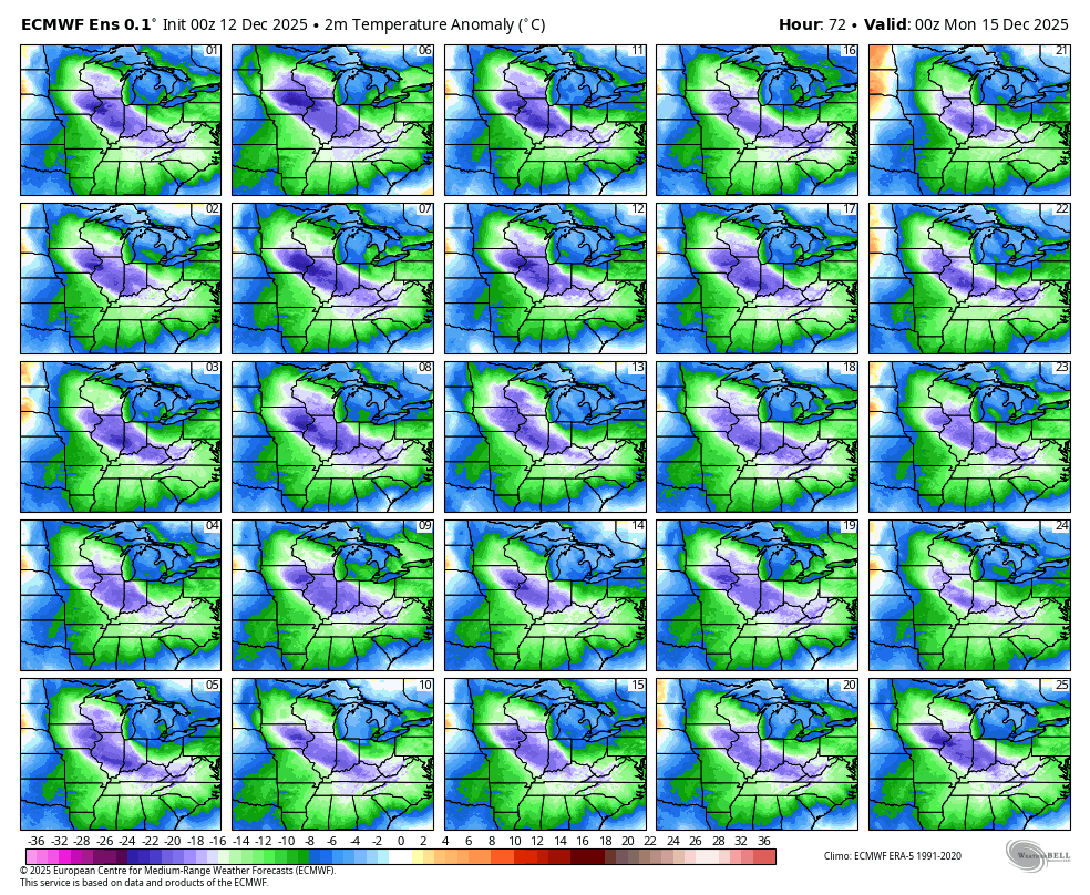
For example, here are the temperature anomalies for this Sunday morning.
Notice all the blue and purple? That equals well below-average temperatures.
Notice how all the squares agree? That means a HIGH (certain) confidence in the forecast outcome.
.
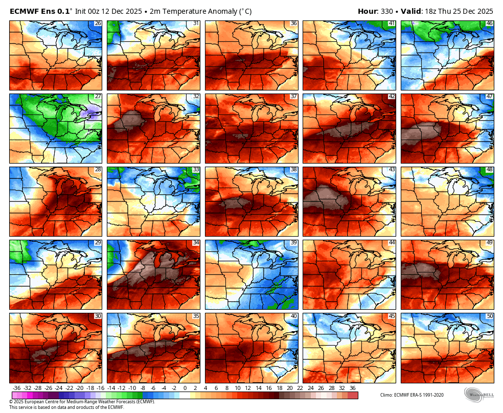
Now, let’s look ahead.
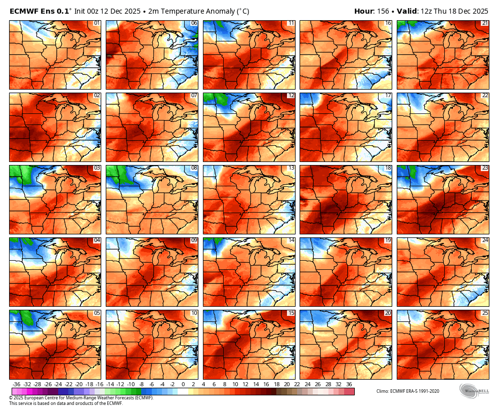
Here is the forecast for Thursday, December 18th. A lot of orange and red. That indicates above-average temperatures.
.
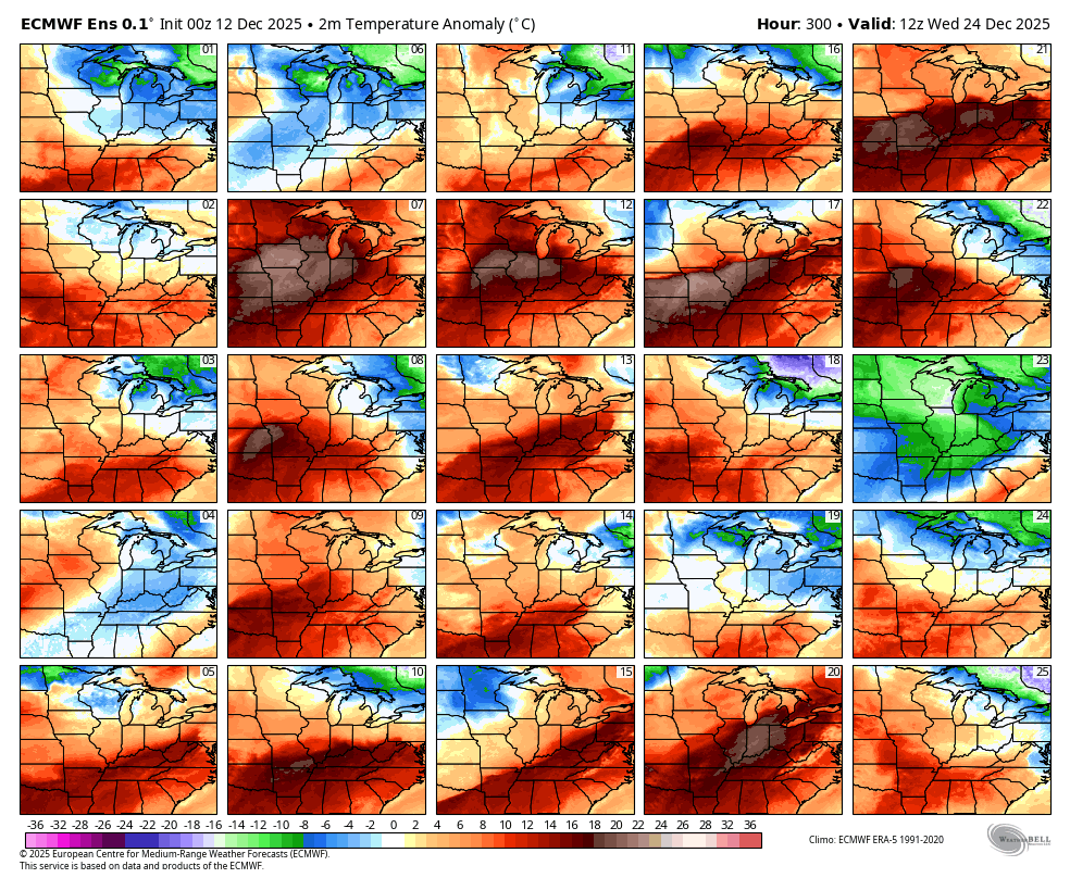
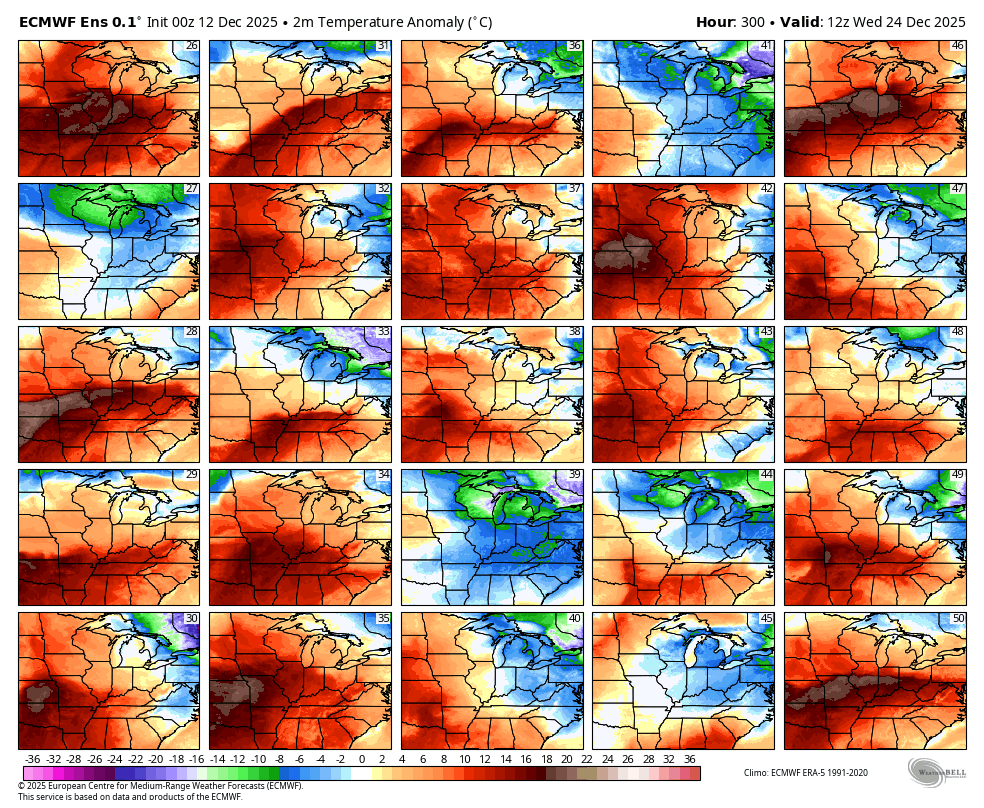
Here is December 24th. Again, a lot of orange and red. Above-average temperatures.
.
Here is December 24th. Again, a lot of orange and red. Above-average temperatures.
A couple of squares show colder than average. So, for now, we monitor trends.
.
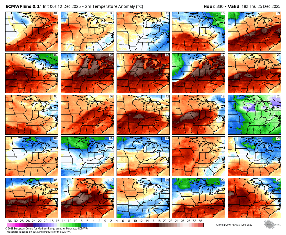
Here is December 25th. Again, a lot of orange and red. Above-average temperatures.
The above-average squares are beating the blue/green squares.
.
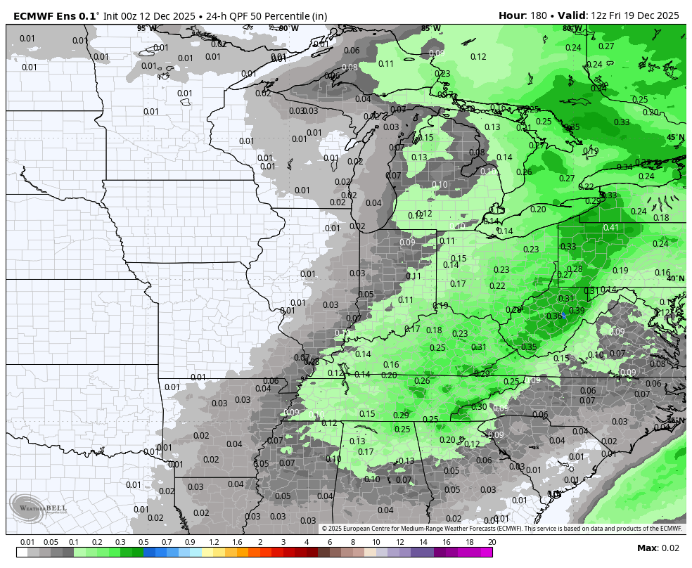
Let’s look at precipitation.
A rain system around the 18th and 19th.
For now, I have a 30% chance of showers on Wednesday and Thursday. I will monitor trends.
.
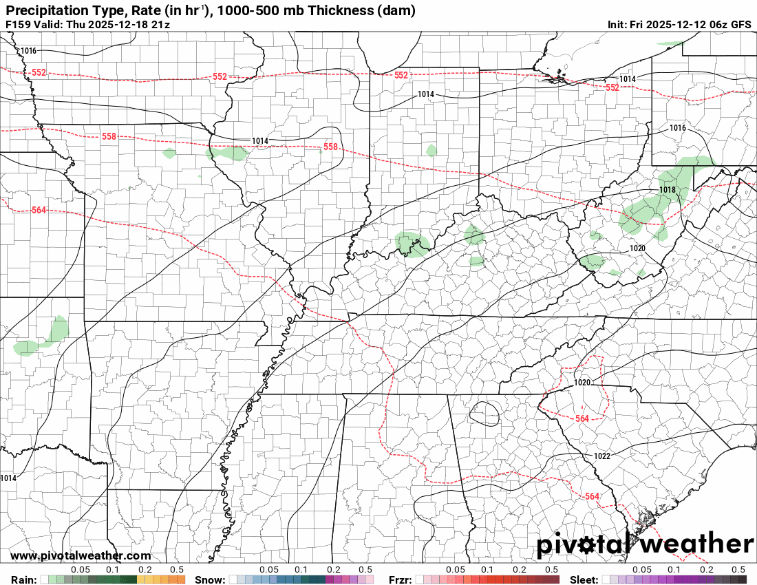
I am watching the 23rd through 26th for a chance of showers. A bit early for certainties on that.
Models are hinting at precipitation along a boundary. The GFS is a bit more bullish than the EC model.
Neither shows snow or ice at this time. They both show temperatures warm enough for rain.
GFS model for this coming Thursday into the weekend.
.
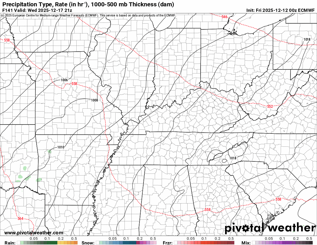
EC long-range model
This coming Thursday into the following week. It shows on and off showers and even thunderstorms.
.

.
The timestamp (upper left) is in Zulu. 12z=6 am. 18z=12 pm. 00z=6 pm.
Double-click the animation to enlarge it.
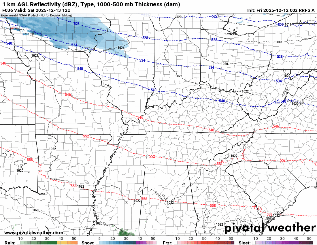
RRFS model
The models below show you the system that will push across the region on Saturday (tomorrow).
Green is rain. Blue is snow. Pink, red, and purple are freezing rain and sleet.
.
.
The timestamp (upper left) is in Zulu. 12z=6 am. 18z=12 pm. 00z=6 pm.
Double-click the animation to enlarge it.
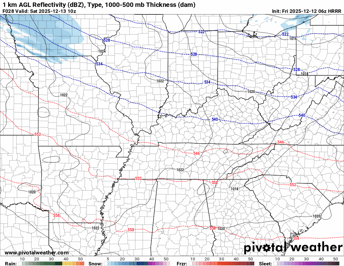
Hrrr model
Green is rain. Blue is snow. Pink, red, and purple are freezing rain and sleet.
.
The timestamp (upper left) is in Zulu. 12z=6 am. 18z=12 pm. 00z=6 pm.
Double-click the animation to enlarge it.
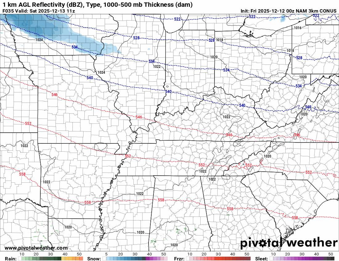
NAM model
Green is rain. Blue is snow. Pink, red, and purple are freezing rain and sleet.
.
.
..
.
Click here if you would like to return to the top of the page.
.Average high temperatures for this time of the year are around 50 degrees.
Average low temperatures for this time of the year are around 32 degrees.
Average precipitation during this time period ranges from 1.00″ to 1.25″
Six to Ten Day Outlook.
Blue is below average. Red is above average. The no color zone represents equal chances.
Average highs for this time of the year are in the lower 60s. Average lows for this time of the year are in the lower 40s.

Green is above average precipitation. Yellow and brown favors below average precipitation. Average precipitation for this time of the year is around one inch per week.

.

Average low temperatures for this time of the year are around 31 degrees.
Average precipitation during this time period ranges from 1.00″ to 1.25″
.
Eight to Fourteen Day Outlook.
Blue is below average. Red is above average. The no color zone represents equal chances.

Green is above average precipitation. Yellow and brown favors below average precipitation. Average precipitation for this time of the year is around one inch per week.

.
.
.
We have a new service to complement your www.weathertalk.com subscription. This does NOTreplace www.weathertalk.com It is simply another tool for you to receive severe weather information.
.
https://weathercallservices.com/beau-dodson-weather


Want to receive the daily forecast/other products on your Beau Dodson Weather app?
Did you know you have four options in your www.weathertalk.com account
You will then receive these via your Beau Dodson Weather app.
Just log into your www.weathertalk.com account
Click the NOTIFICATION SETTINGS TAB
Then, turn them on (green) and off (red)
🌪️ Number 1 is the most important one. Severe alerts, tornado alerts, and so on.
Number 2 is the daily video, blog, livestream alerts, and severe weather Facebook threads on severe days or winter storm days.
Number 3 is the daily forecast. I send that out every day during the afternoon hours. It is the seven-day forecast, hazardous weather outlook, fire outlook, and more.
Number 4 is to receive the daily video, blog, and other content on NON-severe weather days (every day without severe threats in other words)
GREEN IS ON
RED IS OFF

I am going to start going live during bigger severe weather events.
Check it out here https://www.youtube.com/user/beaudodson
Click the subscribe button (it’s a free subscription button), and it will alert you when I go live. I will also send out alerts to the app when I go live for an event.

.

Radars and Lightning Data
Interactive-city-view radars. Clickable watches and warnings.
https://wtalk.co/B3XHASFZ
Old legacy radar site (some of you like it better)
https://weatherobservatory.com/weather-radar.htm
If the radar is not updating then try another one. If a radar does not appear to be refreshing then hit Ctrl F5. You may also try restarting your browser.
Backup radar site in case the above one is not working.
https://weathertalk.com/morani
Regional Radar
https://imagery.weathertalk.com/prx/RadarLoop.mp4
** NEW ** Zoom radar with chaser tracking abilities!
ZoomRadar
If the radar is not working, then email me: Email me at beaudodson@usawx.com
.
We do have some sponsors! Check them out.
Roof damage from recent storms? Link – Click here
INTEGRITY ROOFING AND EXTERIORS!
⛈️ Roof or gutter damage from recent storms? Today’s weather is sponsored by Integrity Roofing. Check out their website at this link https://www.ourintegritymatters.com/

![]()
![]()
![]()
Make sure you have three to five ways of receiving your severe weather information.
Weather Talk is one of those ways! Now, I have another product for you and your family.

.
Want to add more products to your Beau Dodson Weather App?
Receive daily videos, weather blog updates on normal weather days and severe weather and winter storm days, your county by county weather forecast, and more!
Here is how to do add those additional products to your app notification settings!
Here is a video on how to update your Beau Dodson Weather payment.
The app is for subscribers. Subscribe at www.weathertalk.com/welcome then go to your app store and search for WeatherTalk
Subscribers, PLEASE USE THE APP. ATT and Verizon are not reliable during severe weather. They are delaying text messages.
The app is under WeatherTalk in the app store.

Apple users click here

Android users click here
.
Radars and Lightning Data
Interactive-city-view radars. Clickable watches and warnings.
https://wtalk.co/B3XHASFZ
Old legacy radar site (some of you like it better)
https://weatherobservatory.com/weather-radar.htm
If the radar is not updating then try another one. If a radar does not appear to be refreshing then hit Ctrl F5. You may also try restarting your browser.
Backup radar site in case the above one is not working.
https://weathertalk.com/morani
Regional Radar
https://imagery.weathertalk.com/prx/RadarLoop.mp4
** NEW ** Zoom radar with chaser tracking abilities!
ZoomRadar
Lightning Data (zoom in and out of your local area)
https://wtalk.co/WJ3SN5UZ
Not working? Email me at beaudodson@usawx.com
National map of weather watches and warnings. Click here.
Storm Prediction Center. Click here.
Weather Prediction Center. Click here.
.

Live lightning data: Click here.
Real time lightning data (another one) https://map.blitzortung.org/#5.02/37.95/-86.99
Our new Zoom radar with storm chases
.
.

Interactive GOES R satellite. Track clouds. Click here.
GOES 16 slider tool. Click here.
College of DuPage satellites. Click here
.

Here are the latest local river stage forecast numbers Click Here.
Here are the latest lake stage forecast numbers for Kentucky Lake and Lake Barkley Click Here.
.
.
Find Beau on Facebook! Click the banner.


 .
.