

.
I have some question-and-answer threads over on the Facebook page. Link to those threads CLICK HERE
Or email me at beaudodsonweather@gmail.com
..

🌪️ Seven-Day Tornado Outlook ⛈️
December 5th through December 11th.
Current risk: NONE
Current confidence level: High confidence.
Comments:
.

Seven-Day Hazardous Weather Outlook
1. Is lightning in the forecast? NO.
2. Are organized/widespread severe thunderstorms in the forecast? NO.
4. Will non-thunderstorm winds top 40 mph? NO.
5. Will the temperature fall below 20 degrees? POSSIBLE. On Sunday night. I will monitor next Thursday and Friday night.
6. Is the wind chill forecast to drop below ten degrees? NO.
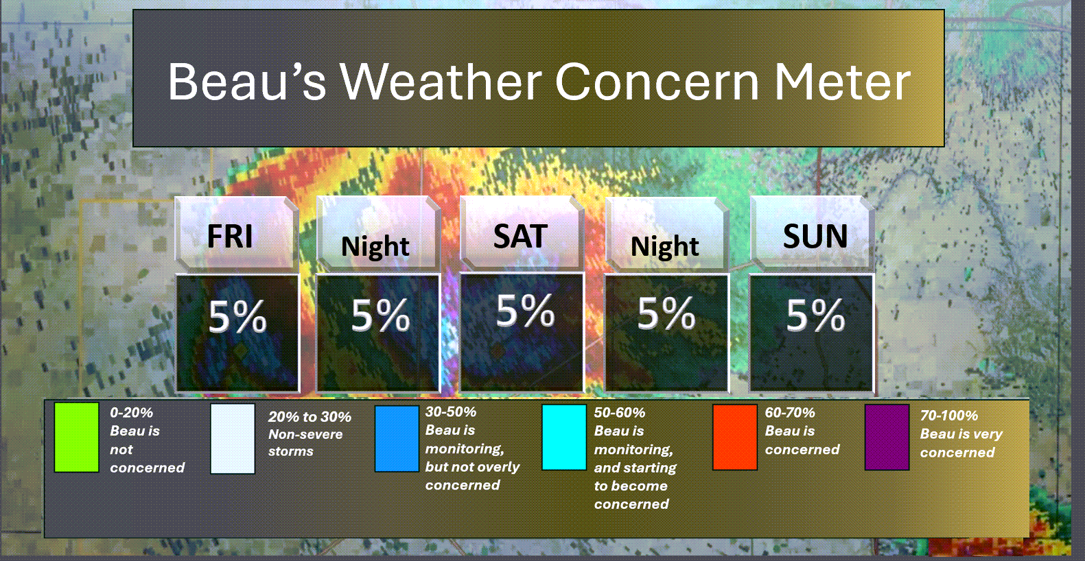
Here is the short-range concern meter.
.
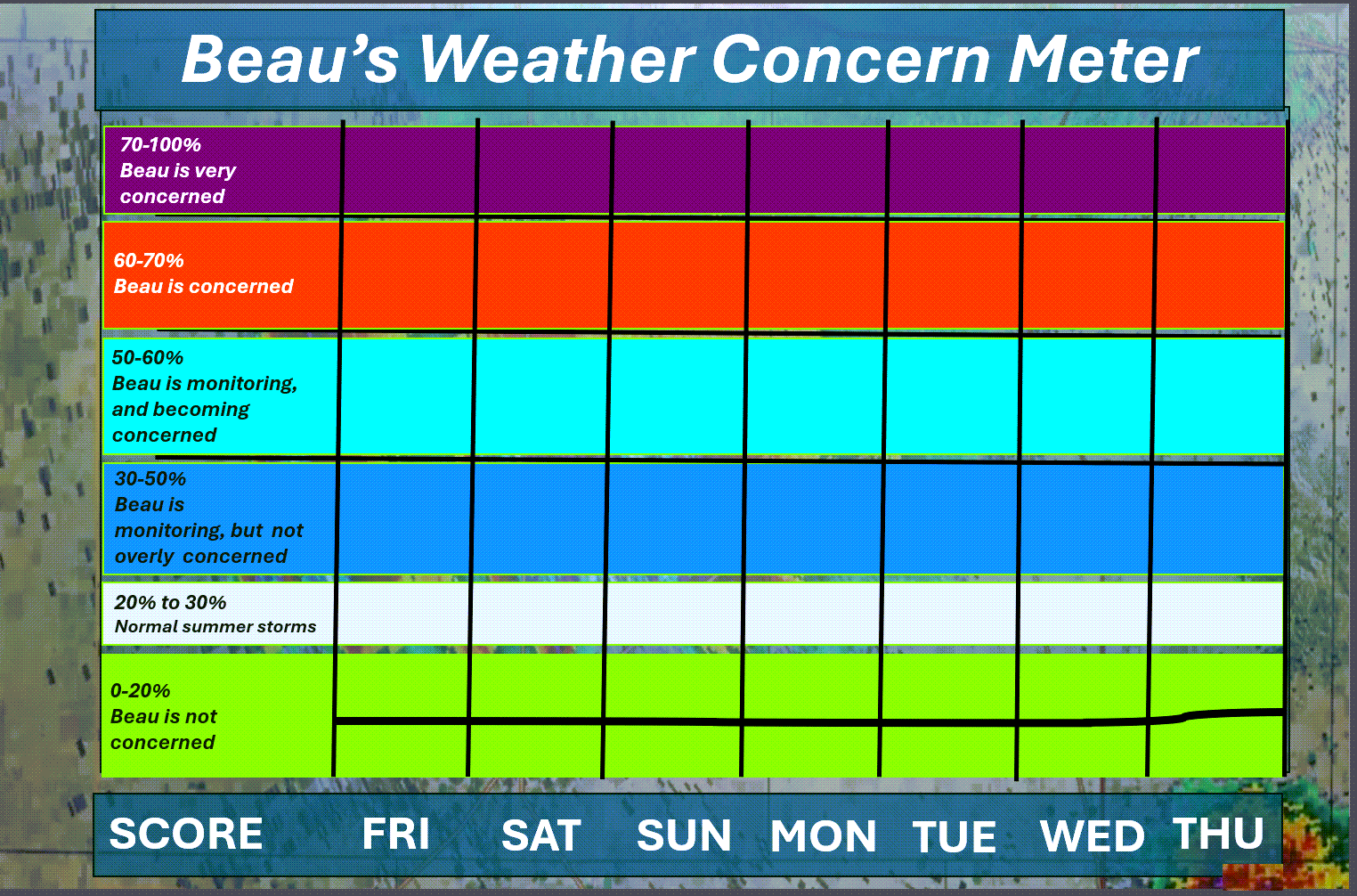
Here is the extended concern meter.
No severe weather concerns.
.
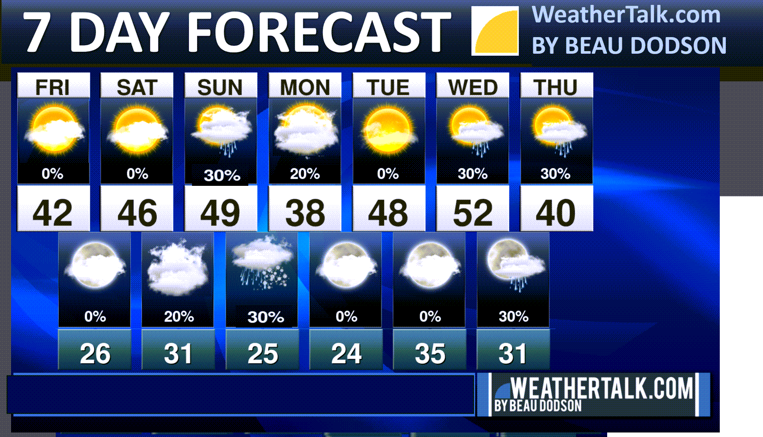
A quick forecast glance. Your 48-hour forecast Graphics


.
Here is your bus stop forecast
This graphic was not updated
.
This afternoon
This graphic was not updated
.


Forecast discussion
- Cold weather to continue into early next week.
- Several fast-moving weak systems to monitor. For now, the chance of a wintry mix remains low. I am closely monitoring it.
- A brief warm-up towards the middle of next week. Then, more cold air.
- Overall, December continues to look colder than seasonal averages. We are certainly off to a cold start.
.
 .
.
.
Seven-day outlook graphic.
See the video for more details specific to your county. This is a broad-brushed outlook for the entire region.
.
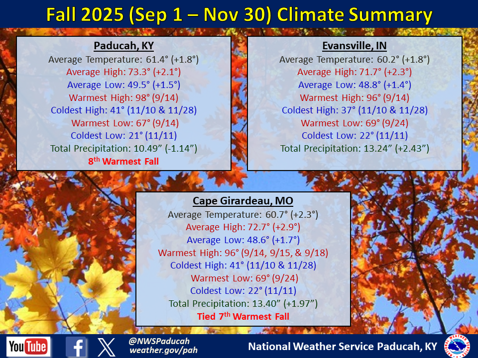
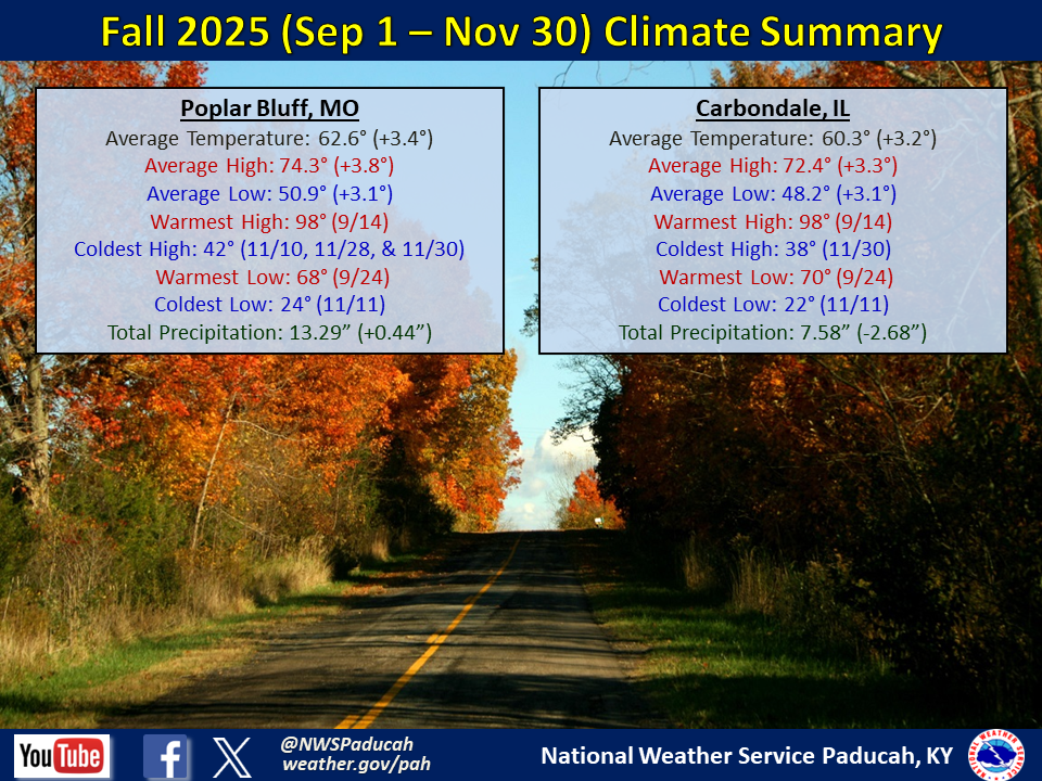
Let’s look at autumn. These statistics are from the Paducah, Kentucky, NWS.
Double-click the image to enlarge it.
These are the average temperatures and precipitation totals from September through November.
.
Today through Sunday
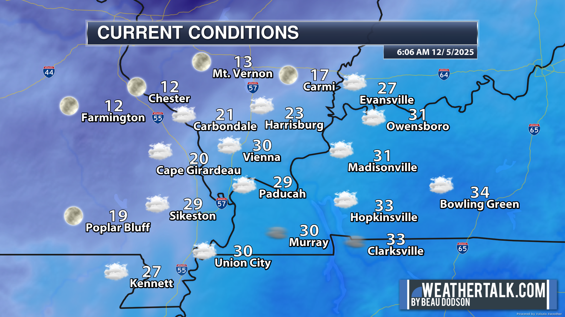
6 AM temperatures
Double brrrr. Some of you are waking up to the coldest air of the winter season, thus far! Check out my northern counties.
That is what happens when clouds clear. Temperatures drop like a rock. Other areas, with clouds, are still around 30 degrees. Big range.
These were the 6 AM air temperatures.
.
We are starting the weekend off on a cold note. It is going to remain chilly into the middle of next week.
Normal highs for this time of the year are around 50 degrees. Normal lows are around 32 degrees.
No weather concerns today. There might be some patchy fog this morning. Use care in those areas.
I am hoping the clouds will clear the region today. Some of you did see the sun yesterday, but many did not. It can be tricky to scour out clouds during the winter months. That has been the problem over the last few days (for some).
Where clouds linger during the day, temperatures tend to be colder. At night, those same clouds keep temperatures a bit warmer. They act like a blanket at night.
We will see temperatures rise into the upper thirties to mid-forties on Saturday. That is ahead of our next cold front.
It will be dry today through Saturday afternoon.
Highs on Sunday should pop back into the forties, as well.
A cold front will push into the region on Saturday night and Sunday. This will bring increasing clouds with a chance of light showers or snow showers. A small chance of freezing rain. This will linger into Sunday night.
At this time, we do not expect any accumulation or impacts. The precipitation is just too light.
Let me show you the precipitation probabilities.
What is the % chance of precipitation?
Saturday 6 PM to Sunday 6 AM
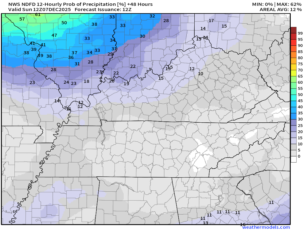
Sunday 6 AM to Sunday 6 PM
Sunday 6 PM to Monday 6 AM
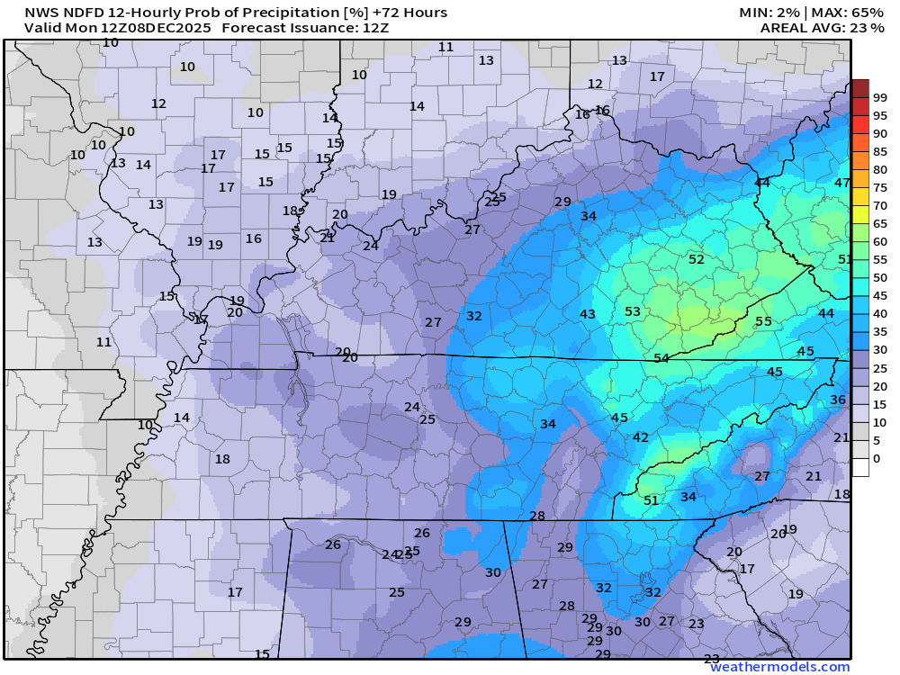
As you can see, the probabilities are low. The totals will be light.
I don’t expect any travel impacts. As always, I will keep an eye on it.
.
Monday through Thursday
Some clouds may linger into Monday. Small chances of precipitation on Monday.
Highs on Monday, behind the cold front, will only pop into the 30s. Cold again.
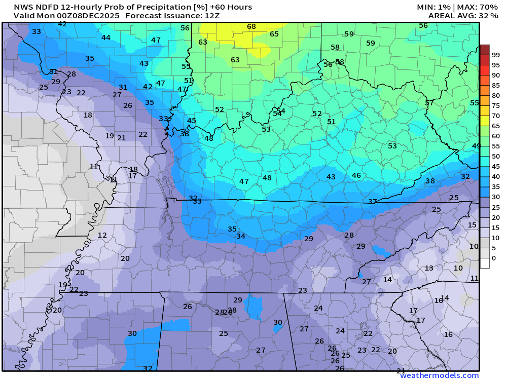
We will warm up a little bit on Tuesday and Wednesday. Then, another cold front will push through the region on Wednesday and Thursday.
That will knock temperatures back down.
At this time, there is a low chance of rain showers on Wednesday and Wednesday night, ahead of the cold front. I can’t rule out some flurries behind the cold front on Thursday and Thursday night.
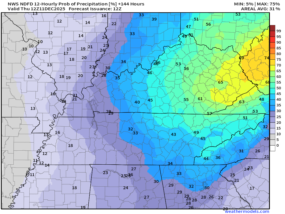
Let’s look at those precipitation probabilities.
Wednesday 6 AM to Wednesday 6 PM
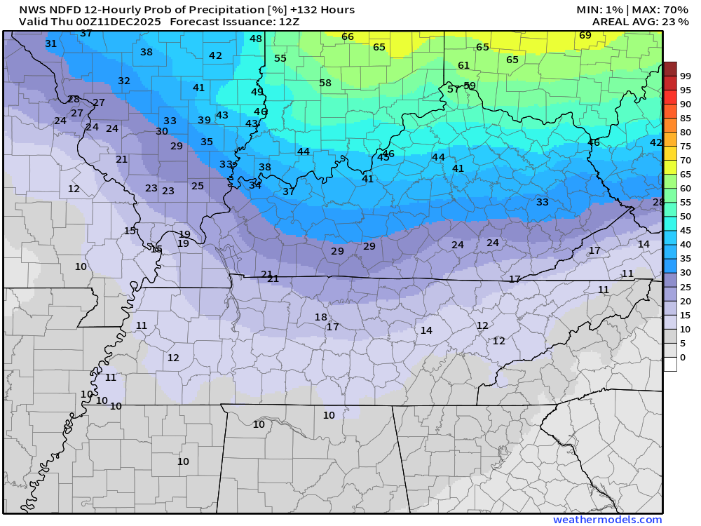
Wednesday 6 PM to Thursday 6 AM
.
At this time, I am not tracking any significant storm systems. Rain or snow.
I do expect several shots of cold air into late December. Some of those cold fronts may bring us some snow. For now, it is just too far out for an accurate forecast.
.

.
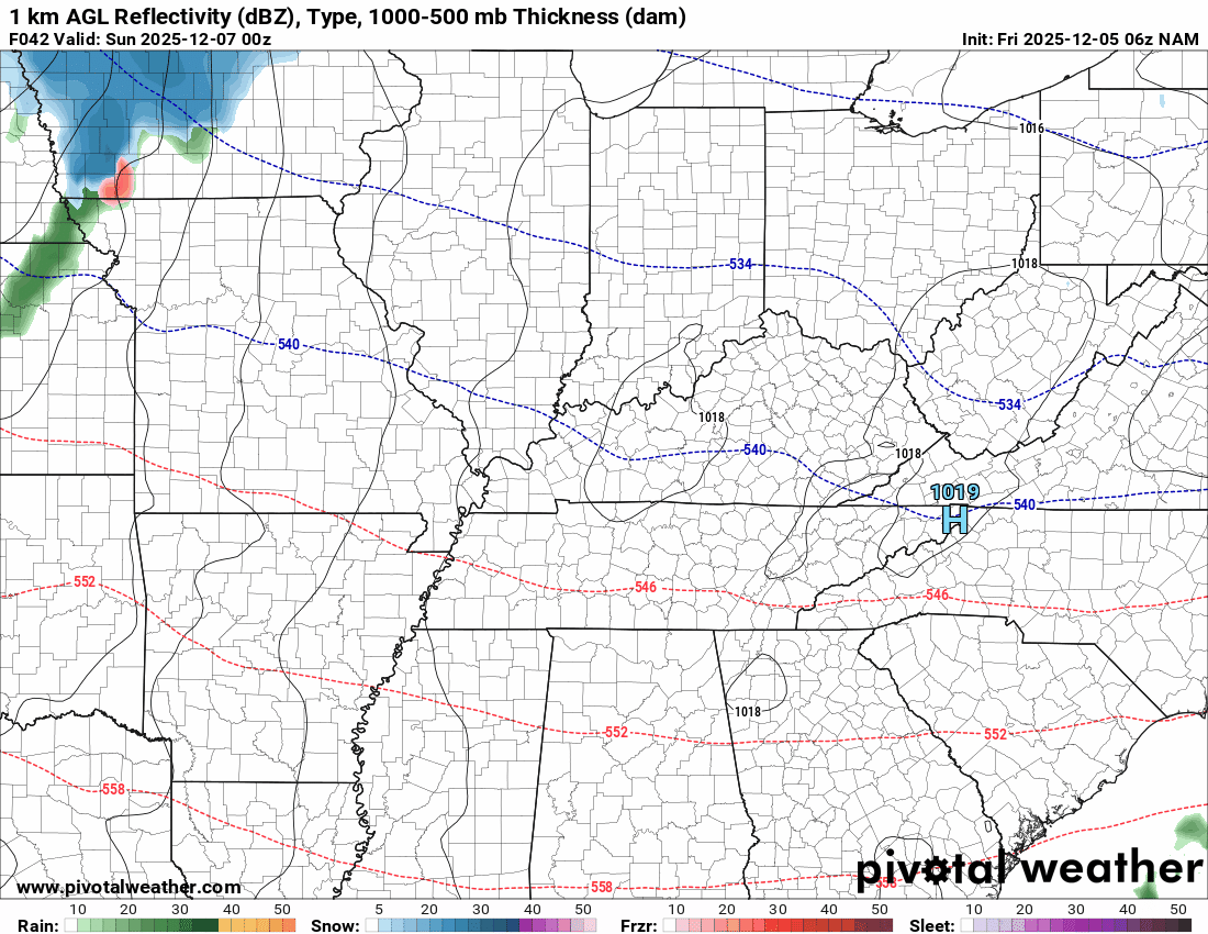
The timestamp (upper left) is in Zulu. 12z=6 am. 18z=12 pm. 00z=6 pm.
Double-click the animation to enlarge it.
NAM model
Green is rain. Blue is snow. Pink, red, and purple are freezing rain and sleet.
.
.
The timestamp (upper left) is in Zulu. 12z=6 am. 18z=12 pm. 00z=6 pm.
Double-click the animation to enlarge it.
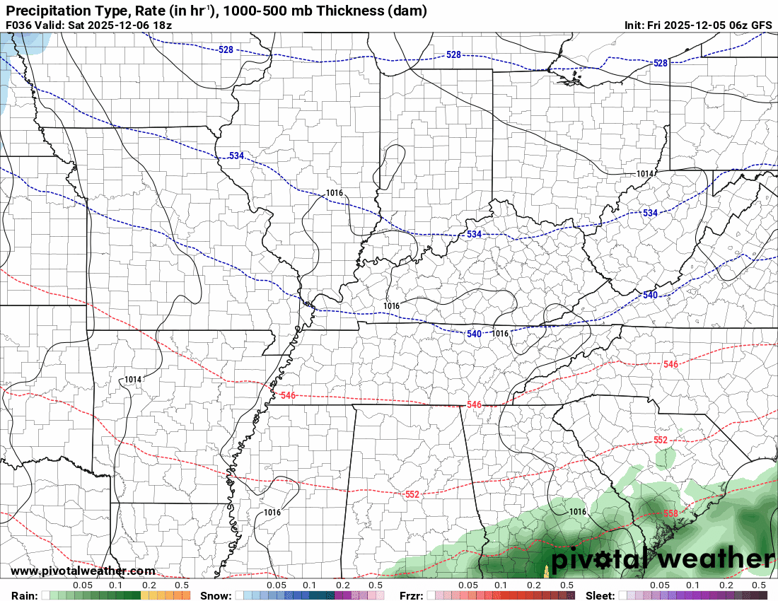
GFS model
Green is rain. Blue is snow. Pink, red, and purple are freezing rain and sleet.
.
.
..
.
Click here if you would like to return to the top of the page.
.Average high temperatures for this time of the year are around 50 degrees.
Average low temperatures for this time of the year are around 32 degrees.
Average precipitation during this time period ranges from 1.00″ to 1.25″
Six to Ten Day Outlook.
Blue is below average. Red is above average. The no color zone represents equal chances.
Average highs for this time of the year are in the lower 60s. Average lows for this time of the year are in the lower 40s.

Green is above average precipitation. Yellow and brown favors below average precipitation. Average precipitation for this time of the year is around one inch per week.

.

Average low temperatures for this time of the year are around 31 degrees.
Average precipitation during this time period ranges from 1.00″ to 1.25″
.
Eight to Fourteen Day Outlook.
Blue is below average. Red is above average. The no color zone represents equal chances.

Green is above average precipitation. Yellow and brown favors below average precipitation. Average precipitation for this time of the year is around one inch per week.

.
.
.
We have a new service to complement your www.weathertalk.com subscription. This does NOTreplace www.weathertalk.com It is simply another tool for you to receive severe weather information.
.
https://weathercallservices.com/beau-dodson-weather


Want to receive the daily forecast/other products on your Beau Dodson Weather app?
Did you know you have four options in your www.weathertalk.com account
You will then receive these via your Beau Dodson Weather app.
Just log into your www.weathertalk.com account
Click the NOTIFICATION SETTINGS TAB
Then, turn them on (green) and off (red)
🌪️ Number 1 is the most important one. Severe alerts, tornado alerts, and so on.
Number 2 is the daily video, blog, livestream alerts, and severe weather Facebook threads on severe days or winter storm days.
Number 3 is the daily forecast. I send that out every day during the afternoon hours. It is the seven-day forecast, hazardous weather outlook, fire outlook, and more.
Number 4 is to receive the daily video, blog, and other content on NON-severe weather days (every day without severe threats in other words)
GREEN IS ON
RED IS OFF

I am going to start going live during bigger severe weather events.
Check it out here https://www.youtube.com/user/beaudodson
Click the subscribe button (it’s a free subscription button), and it will alert you when I go live. I will also send out alerts to the app when I go live for an event.

.

Radars and Lightning Data
Interactive-city-view radars. Clickable watches and warnings.
https://wtalk.co/B3XHASFZ
Old legacy radar site (some of you like it better)
https://weatherobservatory.com/weather-radar.htm
If the radar is not updating then try another one. If a radar does not appear to be refreshing then hit Ctrl F5. You may also try restarting your browser.
Backup radar site in case the above one is not working.
https://weathertalk.com/morani
Regional Radar
https://imagery.weathertalk.com/prx/RadarLoop.mp4
** NEW ** Zoom radar with chaser tracking abilities!
ZoomRadar
If the radar is not working, then email me: Email me at beaudodson@usawx.com
.
We do have some sponsors! Check them out.
Roof damage from recent storms? Link – Click here
INTEGRITY ROOFING AND EXTERIORS!
⛈️ Roof or gutter damage from recent storms? Today’s weather is sponsored by Integrity Roofing. Check out their website at this link https://www.ourintegritymatters.com/

![]()
![]()
![]()
Make sure you have three to five ways of receiving your severe weather information.
Weather Talk is one of those ways! Now, I have another product for you and your family.

.
Want to add more products to your Beau Dodson Weather App?
Receive daily videos, weather blog updates on normal weather days and severe weather and winter storm days, your county by county weather forecast, and more!
Here is how to do add those additional products to your app notification settings!
Here is a video on how to update your Beau Dodson Weather payment.
The app is for subscribers. Subscribe at www.weathertalk.com/welcome then go to your app store and search for WeatherTalk
Subscribers, PLEASE USE THE APP. ATT and Verizon are not reliable during severe weather. They are delaying text messages.
The app is under WeatherTalk in the app store.

Apple users click here

Android users click here
.
Radars and Lightning Data
Interactive-city-view radars. Clickable watches and warnings.
https://wtalk.co/B3XHASFZ
Old legacy radar site (some of you like it better)
https://weatherobservatory.com/weather-radar.htm
If the radar is not updating then try another one. If a radar does not appear to be refreshing then hit Ctrl F5. You may also try restarting your browser.
Backup radar site in case the above one is not working.
https://weathertalk.com/morani
Regional Radar
https://imagery.weathertalk.com/prx/RadarLoop.mp4
** NEW ** Zoom radar with chaser tracking abilities!
ZoomRadar
Lightning Data (zoom in and out of your local area)
https://wtalk.co/WJ3SN5UZ
Not working? Email me at beaudodson@usawx.com
National map of weather watches and warnings. Click here.
Storm Prediction Center. Click here.
Weather Prediction Center. Click here.
.

Live lightning data: Click here.
Real time lightning data (another one) https://map.blitzortung.org/#5.02/37.95/-86.99
Our new Zoom radar with storm chases
.
.

Interactive GOES R satellite. Track clouds. Click here.
GOES 16 slider tool. Click here.
College of DuPage satellites. Click here
.

Here are the latest local river stage forecast numbers Click Here.
Here are the latest lake stage forecast numbers for Kentucky Lake and Lake Barkley Click Here.
.
.
Find Beau on Facebook! Click the banner.


 .
.