

.
I have some question-and-answer threads over on the Facebook page. Link to those threads CLICK HERE
Or email me at beaudodsonweather@gmail.com
..

🌪️ Seven-Day Tornado Outlook ⛈️
October 22nd through October 29th
Current risk: None
Current confidence level: High confidence.
Comments:
.

Seven-Day Hazardous Weather Outlook
1. Is lightning in the forecast? MONITOR. I am monitoring Sunday into Tuesday.
2. Are organized/widespread severe thunderstorms in the forecast? NO.
4. Will non-thunderstorm winds top 40 mph? NO.
5. Will temperatures rise above 90 degrees? NO.
6. Will the temperature fall below 32 degrees? NO.
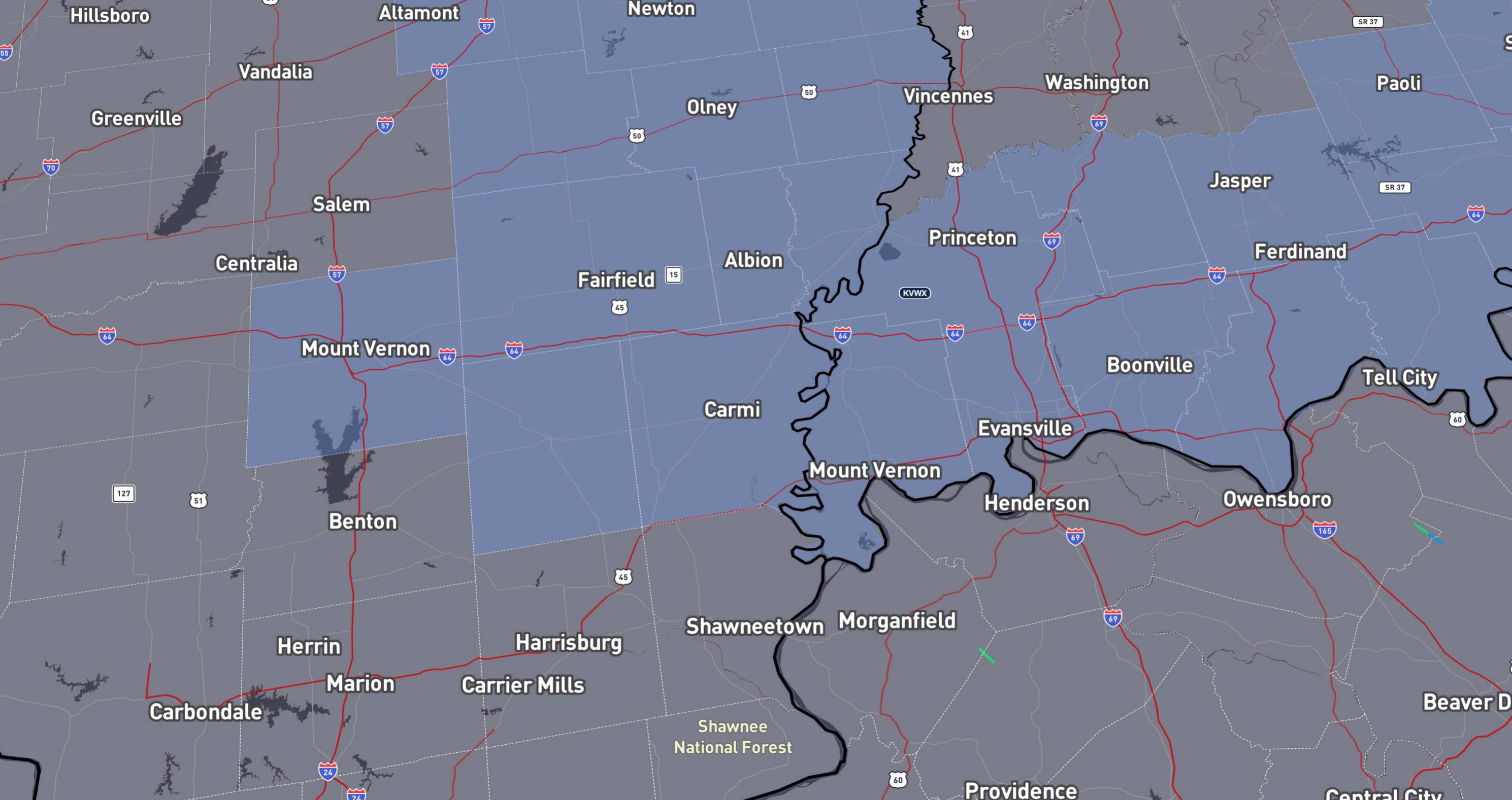
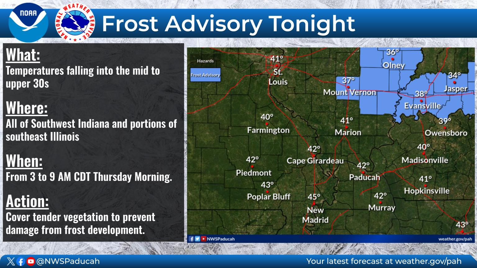
7. Is a killing frost in the forecast? NOT AT THIS TIME. Some frost is possible tonight and especially Thursday night. Mainly over southern Illinois and western Kentucky. The frost may fall short of a killing frost, but portions of southeast Illinois and northwest Kentucky could have a decent frost on Thursday night/Friday morning.
A frost advisory has been issued for Thursday morning for these counties/towns. The blue zone.
Another frost advisory is possible for Thursday night.
Additional counties could be added in future updates. This is where the frost risk is a bit higher.
8. Is accumulating snow or ice in the forecast? NO.
.
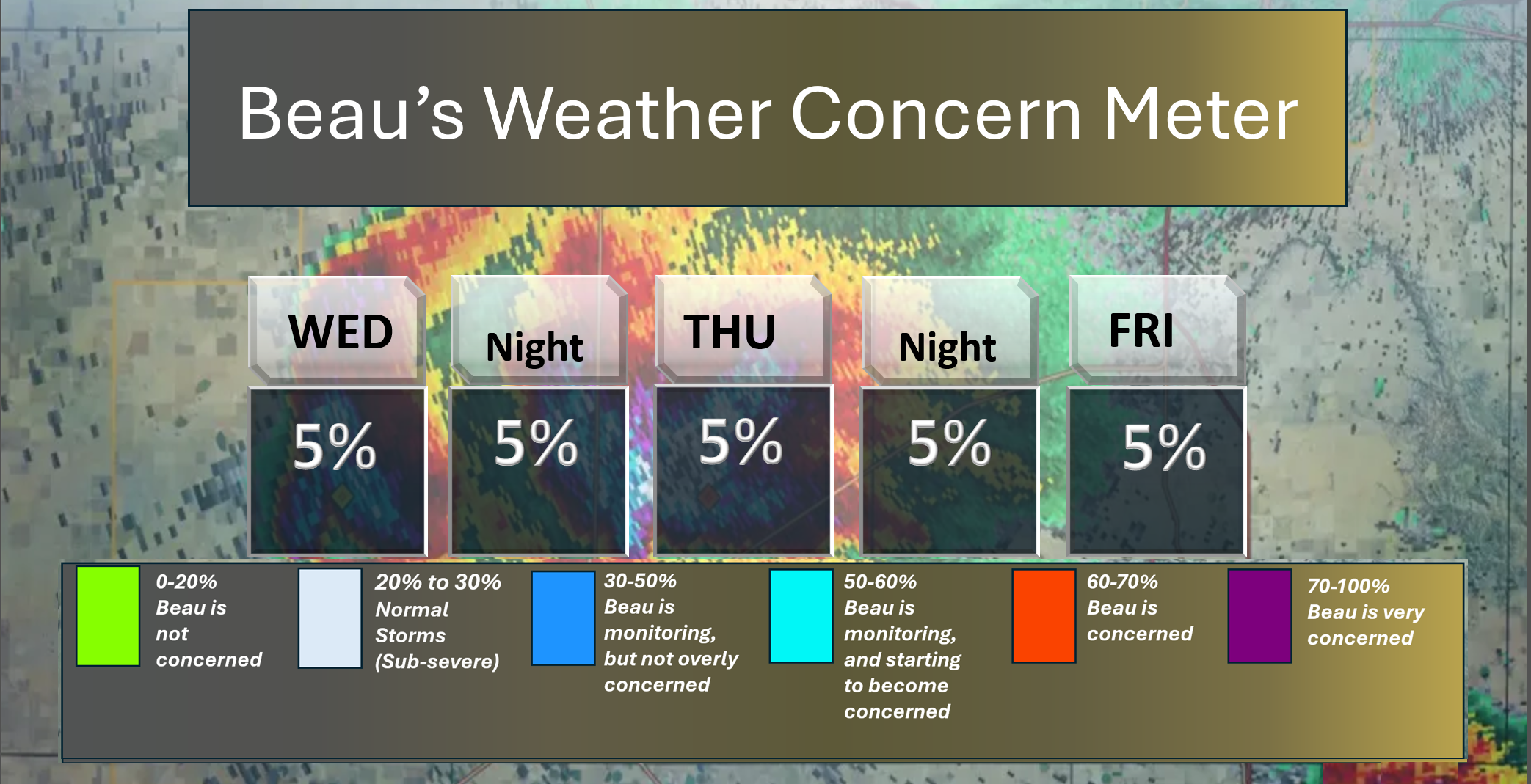
Here is the short-range concern meter.
.
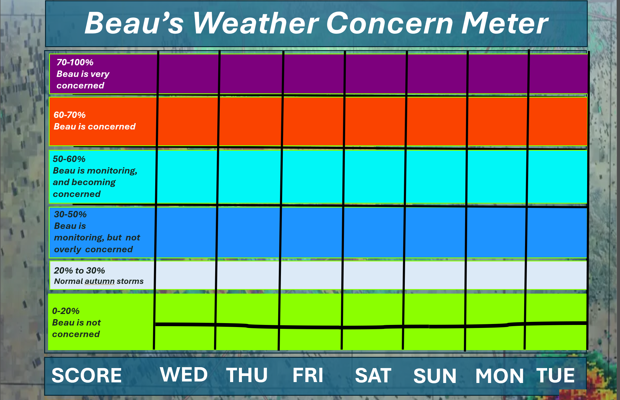
Here is the extended concern meter. This takes us through next Tuesday.
I will monitor Sunday into Tuesday for lightning.
.
A quick forecast glance. Your 48-hour forecast Graphics


.
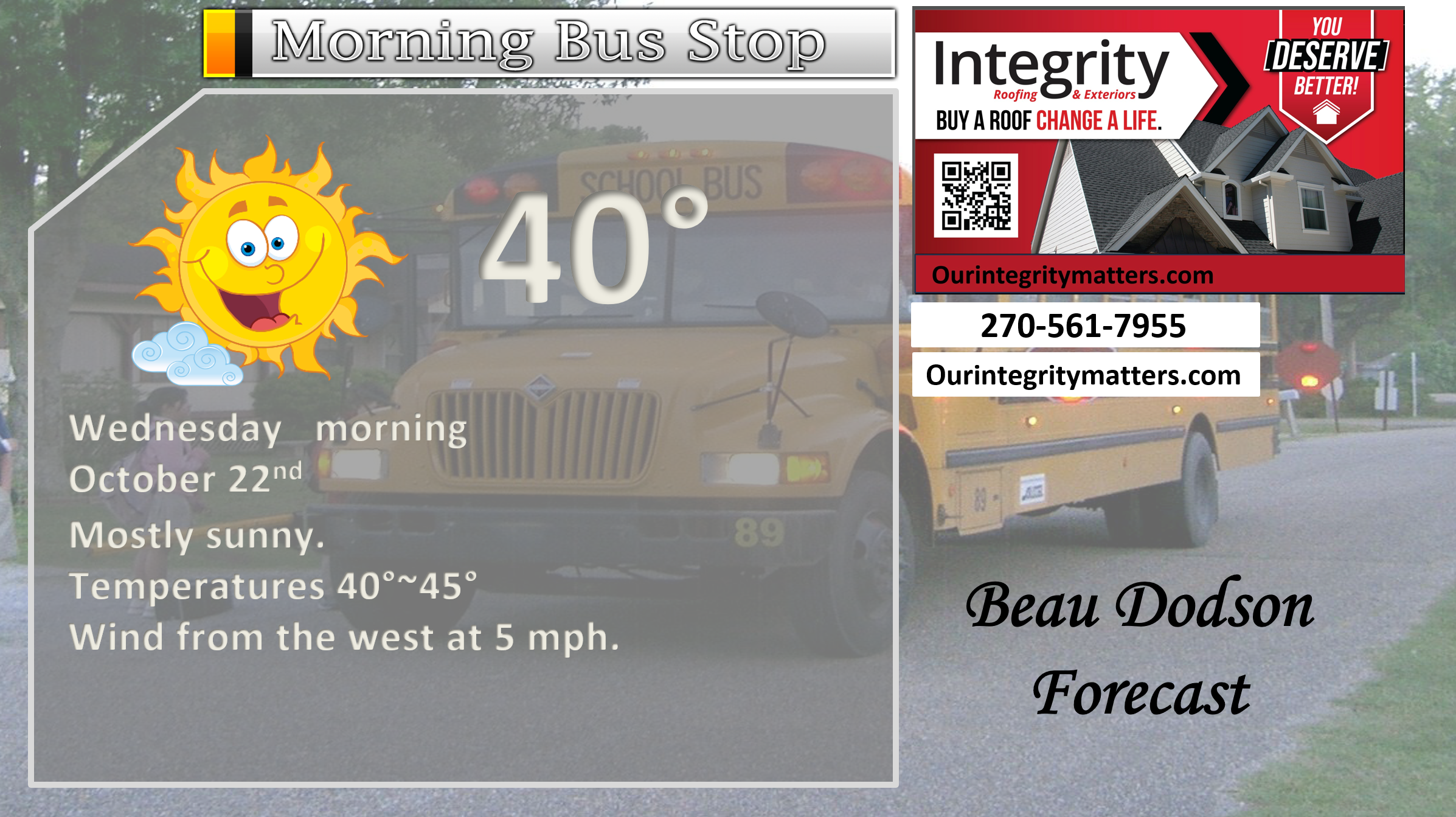
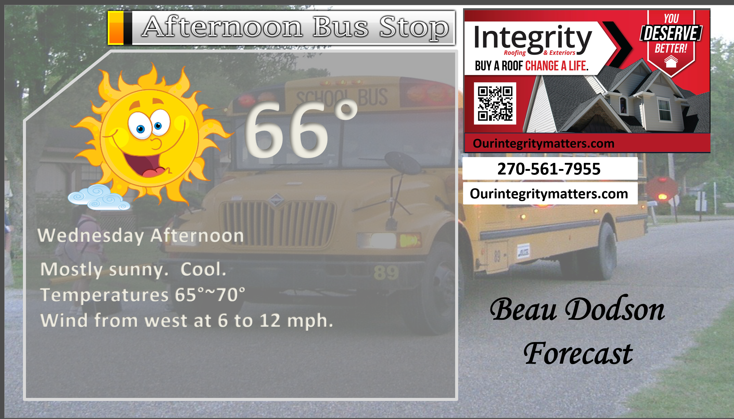
Here is your bus stop forecast.
.
This afternoon
.


Forecast discussion
- Chilly nights.
- Light frost can’t be ruled out tonight and tomorrow night, especially over southern Illinois and western Kentucky.
- Monitoring rain chances on Friday, Saturday, and Sunday. Data is trending drier.
- I am monitoring another system next Monday and Tuesday.
.
 .
.
.
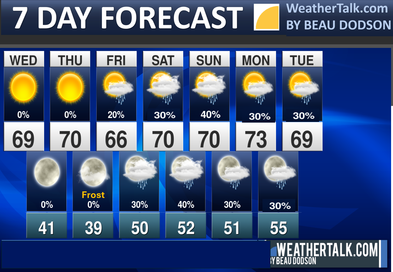
Seven-day outlook graphic.
.
Good morning, everyone.
Today and tomorrow.
Another calm day ahead of us. Winds won’t be as strong today.
We will have some chilly mornings over the coming days.
The coolest mornings will likely be tomorrow and Friday. Areas that tend to be a bit colder will dip into the 30s.
I can’t rule out patchy frost. The risk of frost will be highest on Friday morning. Southeast Missouri and the Bootheel may remain too warm for frost.
The risk is higher across southern Illinois and western Kentucky. Even more so over southeast Illinois and northwest Kentucky.
The Weekend Weather
If you have outdoor plans on Friday, Saturday, and Sunday, then I would not cancel them. Keep an eye on the forecast. A few showers are possible.
I am monitoring rain chances late Friday into Tuesday.
Models are not handling this pattern very well. That is not uncommon during the autumn months as we change seasons. They struggle.
They struggle even more because we lost some of the upper air data due to budget cuts.
This system continues to trend drier. Less rain coverage. With that said, I don’t believe we have fully captured how the weekend event will unfold, given the fluctuating rain probabilities.
For now, peak chances appear to be late Saturday into Sunday. Then, there will be another system next Monday and Tuesday.
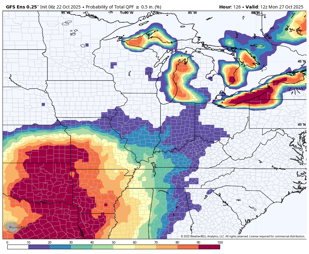
Let me show you the ensembles.
What are the probabilities of 0.50″ or greater of rain falling from 7 AM Friday to 7 AM Monday.
Notice the chances are higher as you travel west-southwest.
GFS ensembles
.
EC model ensembles
What are the probabilities of 0.50″ or greater of rain falling from 7 AM Friday to 7 AM Monday.
.
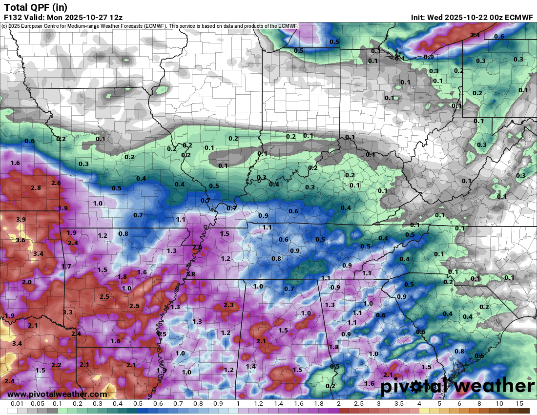
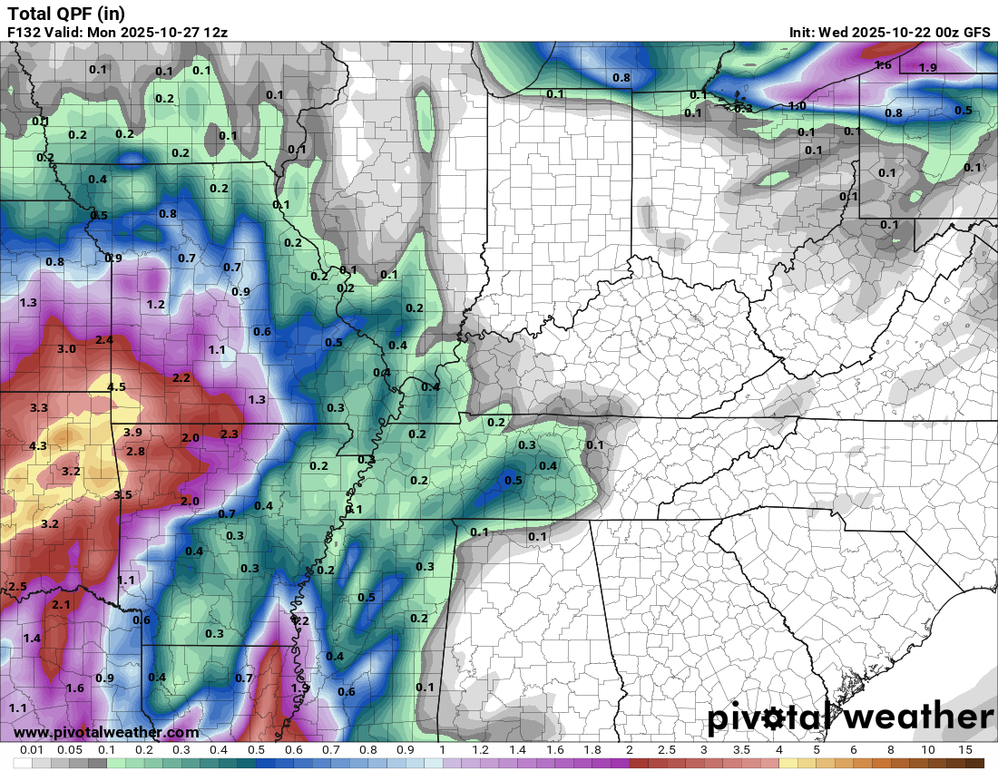
Let’s look at the GFS and EC rainfall totals.
I suspect there will be adjustments in this. This is a tough forecast. The models show portions of the region will have little or no rainfall. Other areas have a decent rain event.
I am monitoring overall trends. Overall trends, over the last three days, have been drier. I will know more tomorrow.
The EC Model.
.
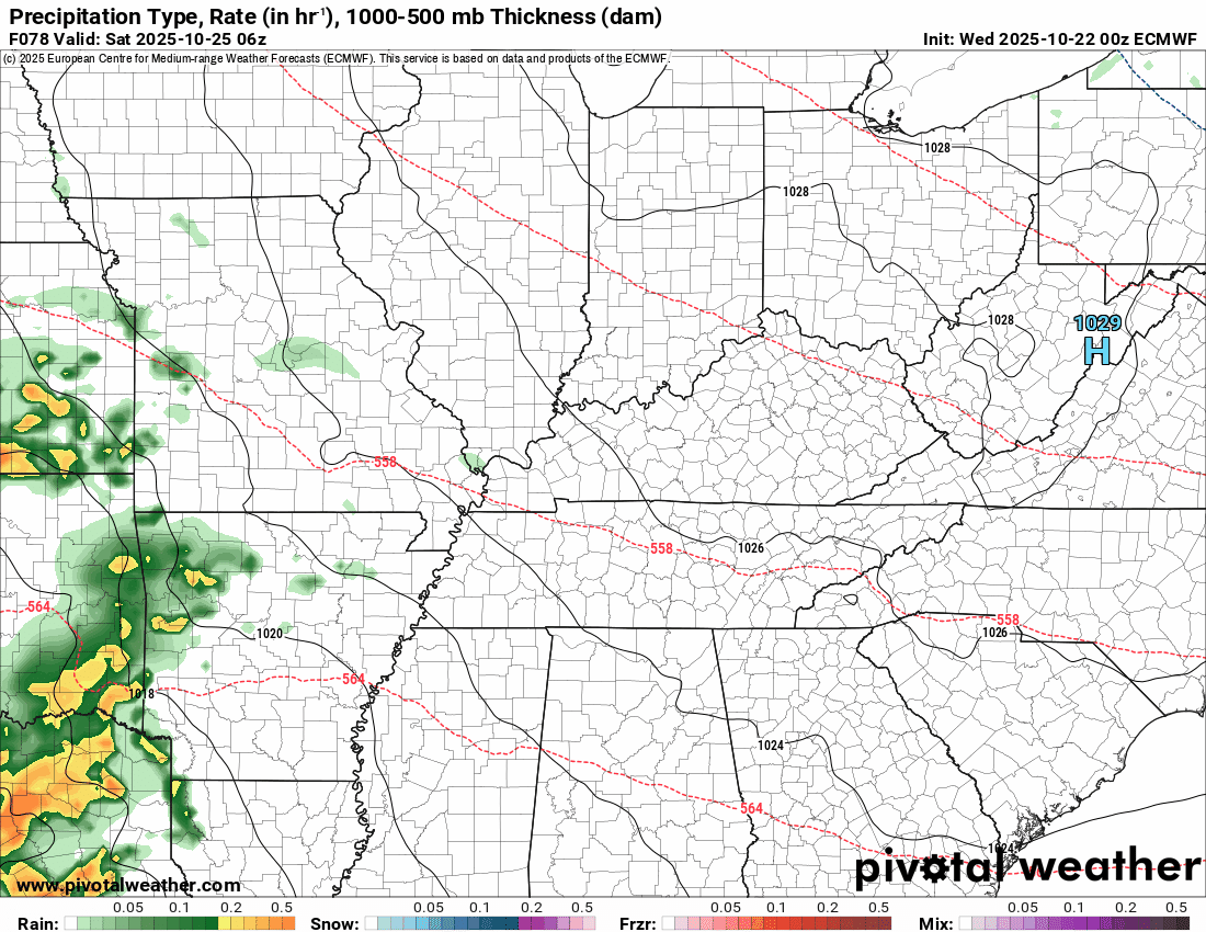
The GFS model
.
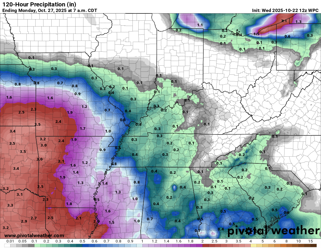
And here is the NOAA/NWS forecast for rain totals through Monday, 7 am.
.
I am watching another cold front next Monday and Tuesday.
It does appear we will have more chances of rain with it. Gusty winds and cooler temperatures will filter in behind it.
Severe weather is not anticipated.
Halloween is shaping up to be cool with highs in the 50s/60s and lows in the 40s.
.

.
The timestamp (upper left) is in Zulu. 12z=7 am. 18z=1 pm. 00z=7 pm.
Double-click the animation to enlarge it.
GFS model
.
The timestamp (upper left) is in Zulu. 12z=7 am. 18z=1 pm. 00z=7 pm.
Double-click the animation to enlarge it.
EC model
.
..
.
Click here if you would like to return to the top of the page.
.Average high temperatures for this time of the year are around 72 degrees.
Average low temperatures for this time of the year are around 47 degrees.
Average precipitation during this time period ranges from 1.00″ to 1.25″
Six to Ten Day Outlook.
Blue is below average. Red is above average. The no color zone represents equal chances.
Average highs for this time of the year are in the lower 60s. Average lows for this time of the year are in the lower 40s.

Green is above average precipitation. Yellow and brown favors below average precipitation. Average precipitation for this time of the year is around one inch per week.

.

Average low temperatures for this time of the year are around 45 degrees.
Average precipitation during this time period ranges from 1.00″ to 1.25″
.
Eight to Fourteen Day Outlook.
Blue is below average. Red is above average. The no color zone represents equal chances.

Green is above average precipitation. Yellow and brown favors below average precipitation. Average precipitation for this time of the year is around one inch per week.

.
.
.
We have a new service to complement your www.weathertalk.com subscription. This does NOTreplace www.weathertalk.com It is simply another tool for you to receive severe weather information.
.
https://weathercallservices.com/beau-dodson-weather


Want to receive the daily forecast/other products on your Beau Dodson Weather app?
Did you know you have four options in your www.weathertalk.com account
You will then receive these via your Beau Dodson Weather app.
Just log into your www.weathertalk.com account
Click the NOTIFICATION SETTINGS TAB
Then, turn them on (green) and off (red)
🌪️ Number 1 is the most important one. Severe alerts, tornado alerts, and so on.
Number 2 is the daily video, blog, livestream alerts, and severe weather Facebook threads on severe days or winter storm days.
Number 3 is the daily forecast. I send that out every day during the afternoon hours. It is the seven-day forecast, hazardous weather outlook, fire outlook, and more.
Number 4 is to receive the daily video, blog, and other content on NON-severe weather days (every day without severe threats in other words)
GREEN IS ON
RED IS OFF

I am going to start going live during bigger severe weather events.
Check it out here https://www.youtube.com/user/beaudodson
Click the subscribe button (it’s a free subscription button), and it will alert you when I go live. I will also send out alerts to the app when I go live for an event.

.

Radars and Lightning Data
Interactive-city-view radars. Clickable watches and warnings.
https://wtalk.co/B3XHASFZ
Old legacy radar site (some of you like it better)
https://weatherobservatory.com/weather-radar.htm
If the radar is not updating then try another one. If a radar does not appear to be refreshing then hit Ctrl F5. You may also try restarting your browser.
Backup radar site in case the above one is not working.
https://weathertalk.com/morani
Regional Radar
https://imagery.weathertalk.com/prx/RadarLoop.mp4
** NEW ** Zoom radar with chaser tracking abilities!
ZoomRadar
If the radar is not working, then email me: Email me at beaudodson@usawx.com
.
We do have some sponsors! Check them out.
Roof damage from recent storms? Link – Click here
INTEGRITY ROOFING AND EXTERIORS!
⛈️ Roof or gutter damage from recent storms? Today’s weather is sponsored by Integrity Roofing. Check out their website at this link https://www.ourintegritymatters.com/

![]()
![]()
![]()
Make sure you have three to five ways of receiving your severe weather information.
Weather Talk is one of those ways! Now, I have another product for you and your family.

.
Want to add more products to your Beau Dodson Weather App?
Receive daily videos, weather blog updates on normal weather days and severe weather and winter storm days, your county by county weather forecast, and more!
Here is how to do add those additional products to your app notification settings!
Here is a video on how to update your Beau Dodson Weather payment.
The app is for subscribers. Subscribe at www.weathertalk.com/welcome then go to your app store and search for WeatherTalk
Subscribers, PLEASE USE THE APP. ATT and Verizon are not reliable during severe weather. They are delaying text messages.
The app is under WeatherTalk in the app store.

Apple users click here

Android users click here
.
Radars and Lightning Data
Interactive-city-view radars. Clickable watches and warnings.
https://wtalk.co/B3XHASFZ
Old legacy radar site (some of you like it better)
https://weatherobservatory.com/weather-radar.htm
If the radar is not updating then try another one. If a radar does not appear to be refreshing then hit Ctrl F5. You may also try restarting your browser.
Backup radar site in case the above one is not working.
https://weathertalk.com/morani
Regional Radar
https://imagery.weathertalk.com/prx/RadarLoop.mp4
** NEW ** Zoom radar with chaser tracking abilities!
ZoomRadar
Lightning Data (zoom in and out of your local area)
https://wtalk.co/WJ3SN5UZ
Not working? Email me at beaudodson@usawx.com
National map of weather watches and warnings. Click here.
Storm Prediction Center. Click here.
Weather Prediction Center. Click here.
.

Live lightning data: Click here.
Real time lightning data (another one) https://map.blitzortung.org/#5.02/37.95/-86.99
Our new Zoom radar with storm chases
.
.

Interactive GOES R satellite. Track clouds. Click here.
GOES 16 slider tool. Click here.
College of DuPage satellites. Click here
.

Here are the latest local river stage forecast numbers Click Here.
Here are the latest lake stage forecast numbers for Kentucky Lake and Lake Barkley Click Here.
.
.
Find Beau on Facebook! Click the banner.


 .
.