

.
I have some question-and-answer threads over on the Facebook page. Link to those threads CLICK HERE
Or email me at beaudodsonweather@gmail.com
..

🌪️ Seven-Day Tornado Outlook ⛈️
October 17th through October 23rd
Current risk: ISOLATED RISK on Saturday afternoon and evening.
Current confidence level: Medium confidence in the forecast.
Comments: We do have a risk of severe weather on Saturday afternoon and Saturday night. The tornado risk remains low, but not zero. I can’t rule out a brief spin-up. Monitor updated forecasts.
.

Seven-Day Hazardous Weather Outlook
1. Is lightning in the forecast? YES. There is a risk of lightning on Saturday and Saturday night. I will monitor Monday night and Tuesday for a low-end lightning risk.
2. Are organized/widespread severe thunderstorms in the forecast? YES. Severe thunderstorms are possible on Saturday afternoon and Saturday night.
The Storm Prediction Center has placed our region in a level one and two risk for Saturday afternoon and Saturday night.
Bottom line: Monitor updated forecasts. A few of the storms on Saturday could be intense.
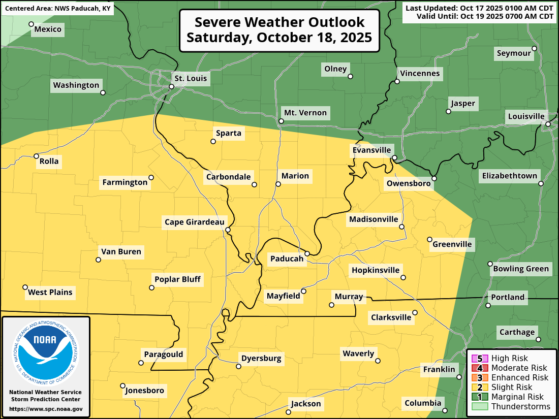
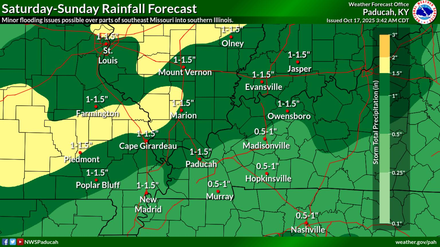
Here is the area the SPC has outlined for a severe weather risk on Saturday/Saturday night.
The yellow zone is the level two risk. Adjustments in this are still possible.
The dark green zone is the lowest risk zone. A level one (marginal) risk.
The yellow zone is a level two (slight) risk.
.3. Is significant or widespread flash flooding in the forecast? NO.
4. Will non-thunderstorm winds top 40 mph? UNLIKELY. Gusty winds are likely on Saturday and Sunday. At this time, it appears non-thunderstorm winds will remain below 40 mph. Generally, winds of 10 to 25 mph are anticipated. Some gusts above 25 mph are likely on Saturday and Sunday.
5. Will temperatures rise above 90 degrees? NO.
6. Will the temperature fall below 32 degrees? NO.
7. Is a killing frost in the forecast? NO.
8. Is accumulating snow or ice in the forecast? NO.
.
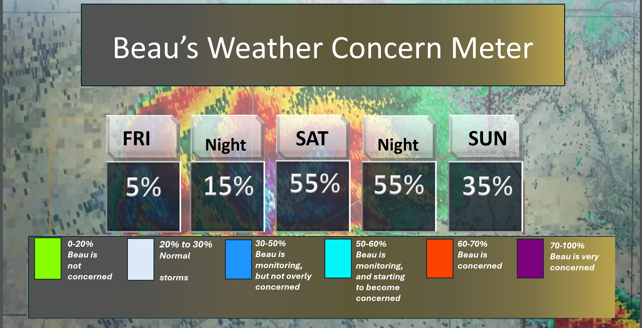
Here is the short-range concern meter.
.
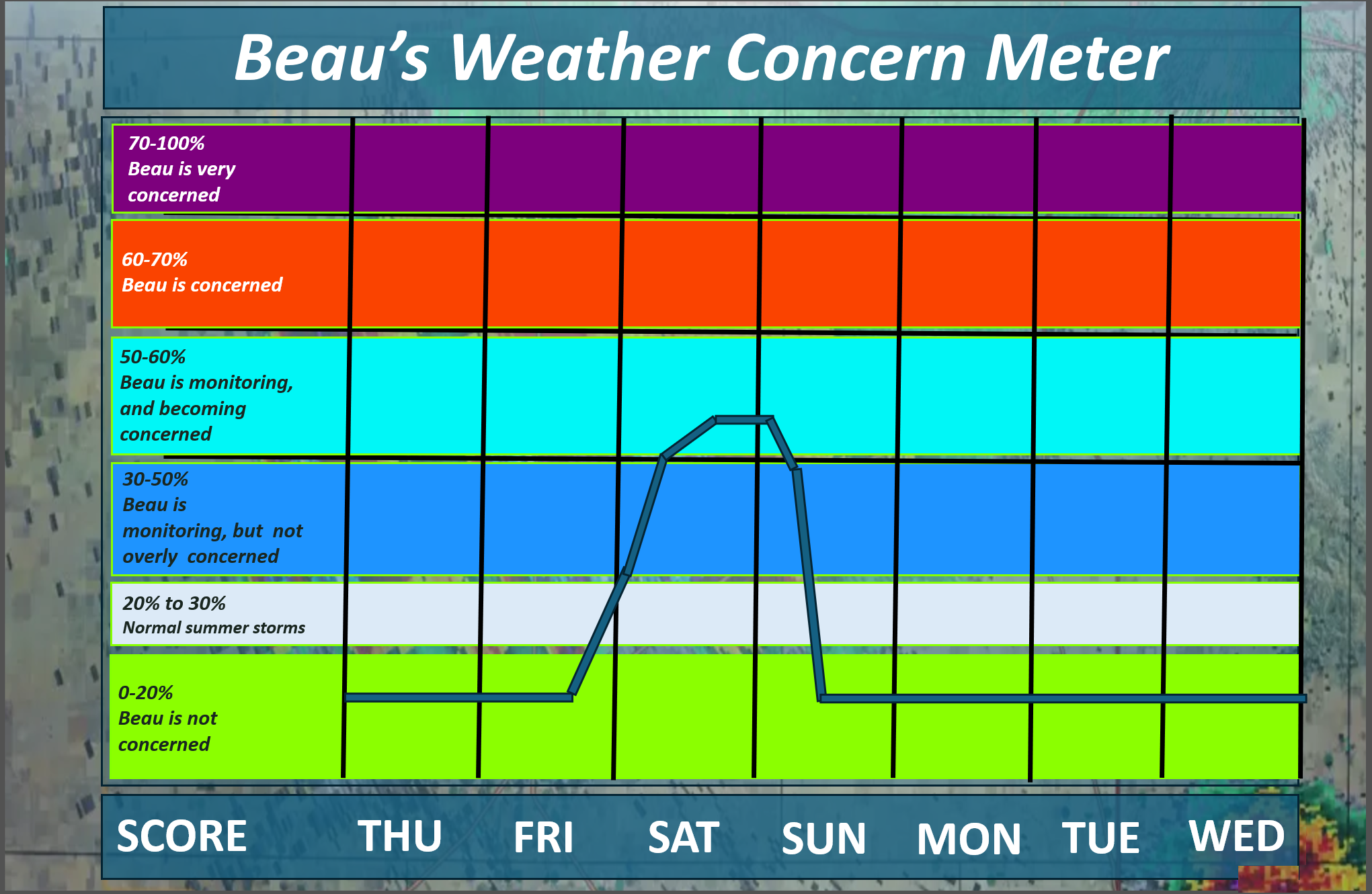
Here is the extended concern meter. This takes us through next Wednesday.
We pop into the light blue on Saturday afternoon and night.
Some of the thunderstorms could be severe with damaging winds and quarter-sized hail. The tornado risk is low, but not zero. A quick spin-up is possible. Long-tracked violent tornadoes are not anticipated.
.
A quick forecast glance. Your 48-hour forecast Graphics


.
Here is your bus stop forecast.
This graphic was not updated.
No concerns at the bus stop this morning.
.
This afternoon
This graphic was not updated.
No concerns at the bus stop this afternoon.
.


Forecast discussion
- Well above-average temperatures through Saturday. Then, cooler temperatures next week.
- Shower and thunderstorm chances will increase on Saturday and Saturday night. Tapering late Saturday night/Sunday morning.
- I would not cancel your Saturday plans. I would, however, throw a rain jacket and umbrella in the car. Be prepared in case showers and storms move in. Most of the morning should be dry (low-end rain chances). During the afternoon and overnight hours, shower and thunderstorm chances ramp up from west to east. Most of the day will likely be dry over the eastern half of the region.
- Some of the thunderstorms could be intense on Saturday afternoon and Saturday night. A few warnings are possible. Monitor updates.
.
 .
.
.
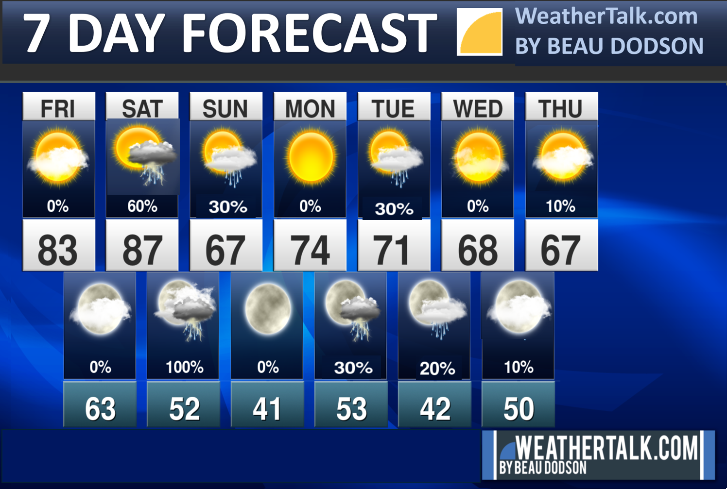
Seven-day outlook graphic.
.
Good Friday morning, everyone. I hope you are having a nice week.
Bottom line: I would not cancel your Saturday plans. If you have outdoor plans on Saturday and Saturday night, then carry an umbrella and a rain jacket. Then, if it rains, you will be prepared. Monitor your Beau Dodson Weather App (and other sources) for the latest watches and warnings. A few of the storms could become severe with high wind gusts and quarter-sized hail. The tornado risk is low, but not zero.
Rain chances before 12 pm will be lower than in the afternoon and evening hours. It is not a zero chance of morning showers, but the chance is lower and they will be widely scattered.
The primary time frame of concern will be Saturday afternoon into Saturday night. The eastern half of the region may remain dry for most of the day. Keep that in mind. See the daily video for more information.
I know there are many outdoor events on Saturday, so we will hope for the best.
I did not make any significant adjustments to the going forecast.
Once again, today will be nice. Warm. Increasing clouds.
Winds will begin to become a bit more gusty tonight. Gusty winds into Sunday. Occasionally, gusts will top 25 mph, mainly on Saturday and Sunday.
Temperatures will be well above average today and tomorrow.
No significant weather concerns through Friday afternoon.
A strong cold front will approach the region on Saturday afternoon and Saturday night. This front will bring warm temperatures, increasing humidity levels, higher dew points, and showers/thunderstorms.
The bulk of the shower and thunderstorm activity will arrive during the afternoon hours.
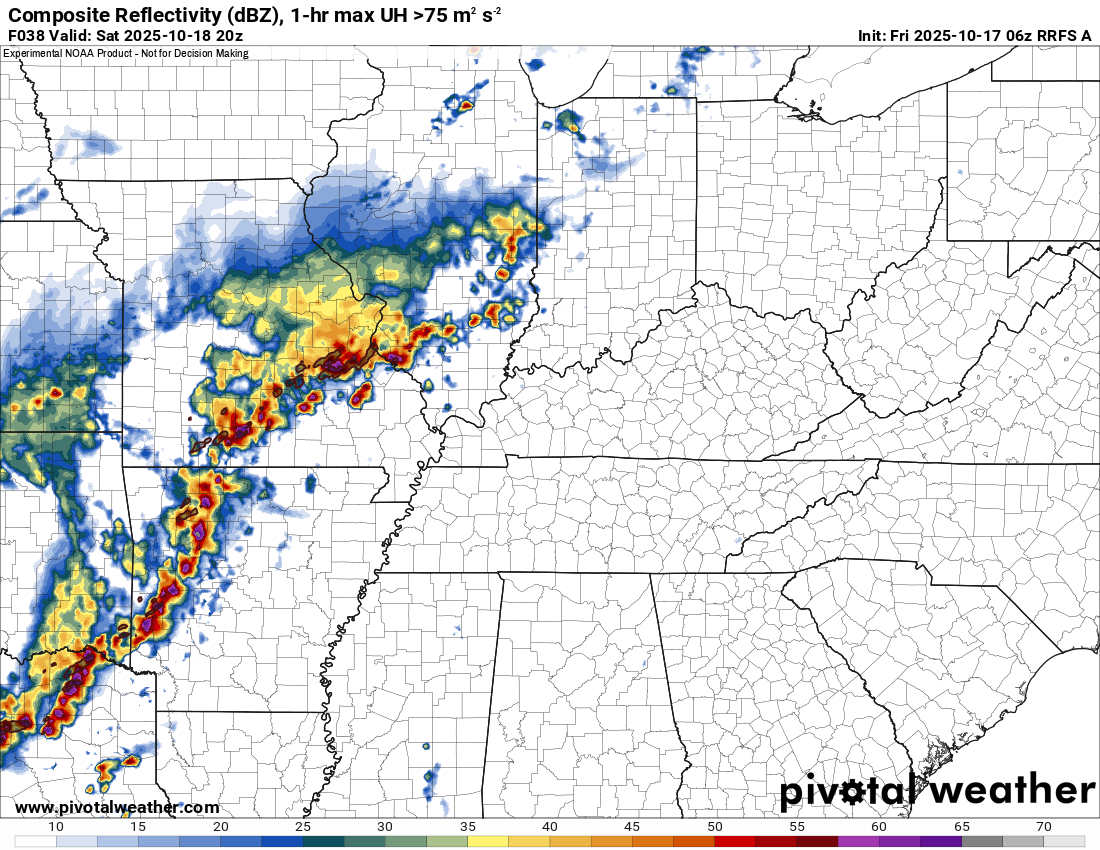
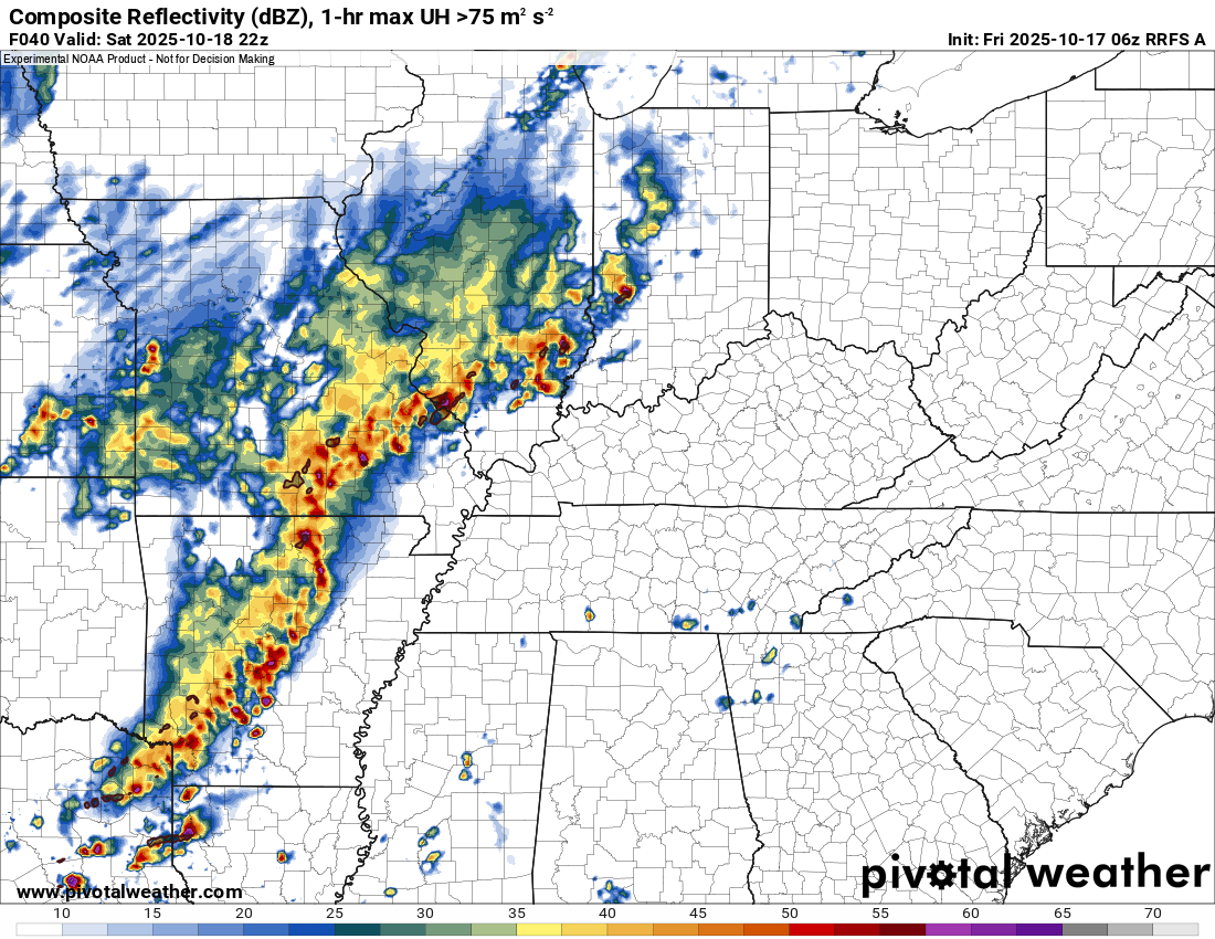
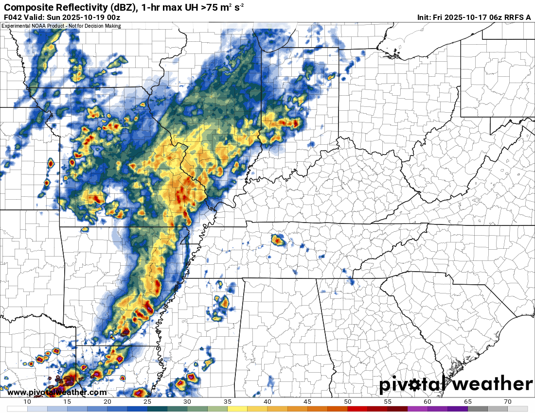
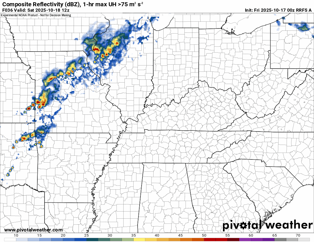
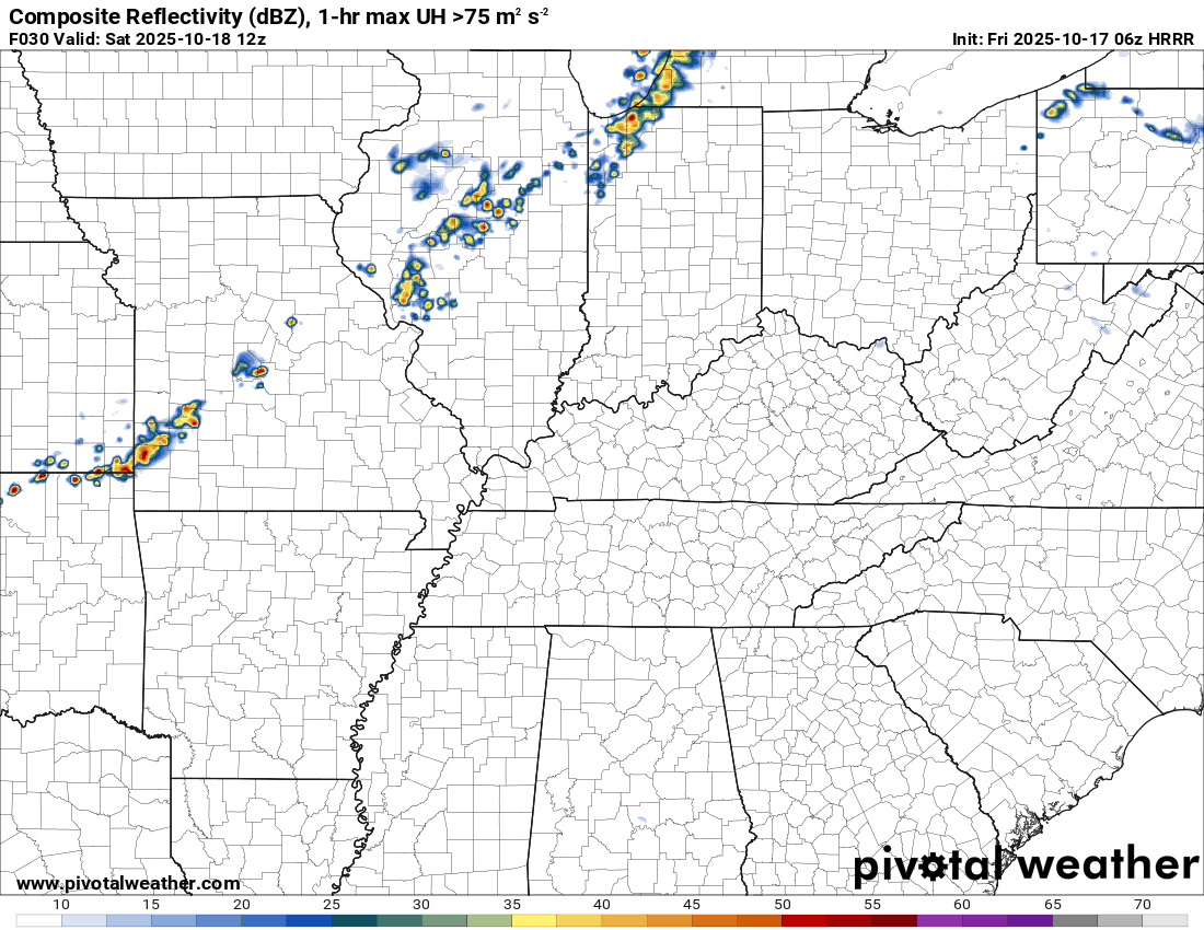
Here is what one of the high-resolution models is showing.
This won’t be exact, but take the general idea from it. A band of showers and storms will push from west to east across the region.
I will need to monitor to see if storms form ahead of the line, as well.
This is around 2 to 3 PM. A line of showers and storms is moving into southwest Illinois and southeast Missouri.
This is around 4 to 5 pm. The line continues to push eastward.
This is around 7 pm on Saturday evening. The line continues to push across the region.
Again, this may not be exact. The line could be a bit farther east than shown on this model. Monitor updates if you have outdoor plans.
.
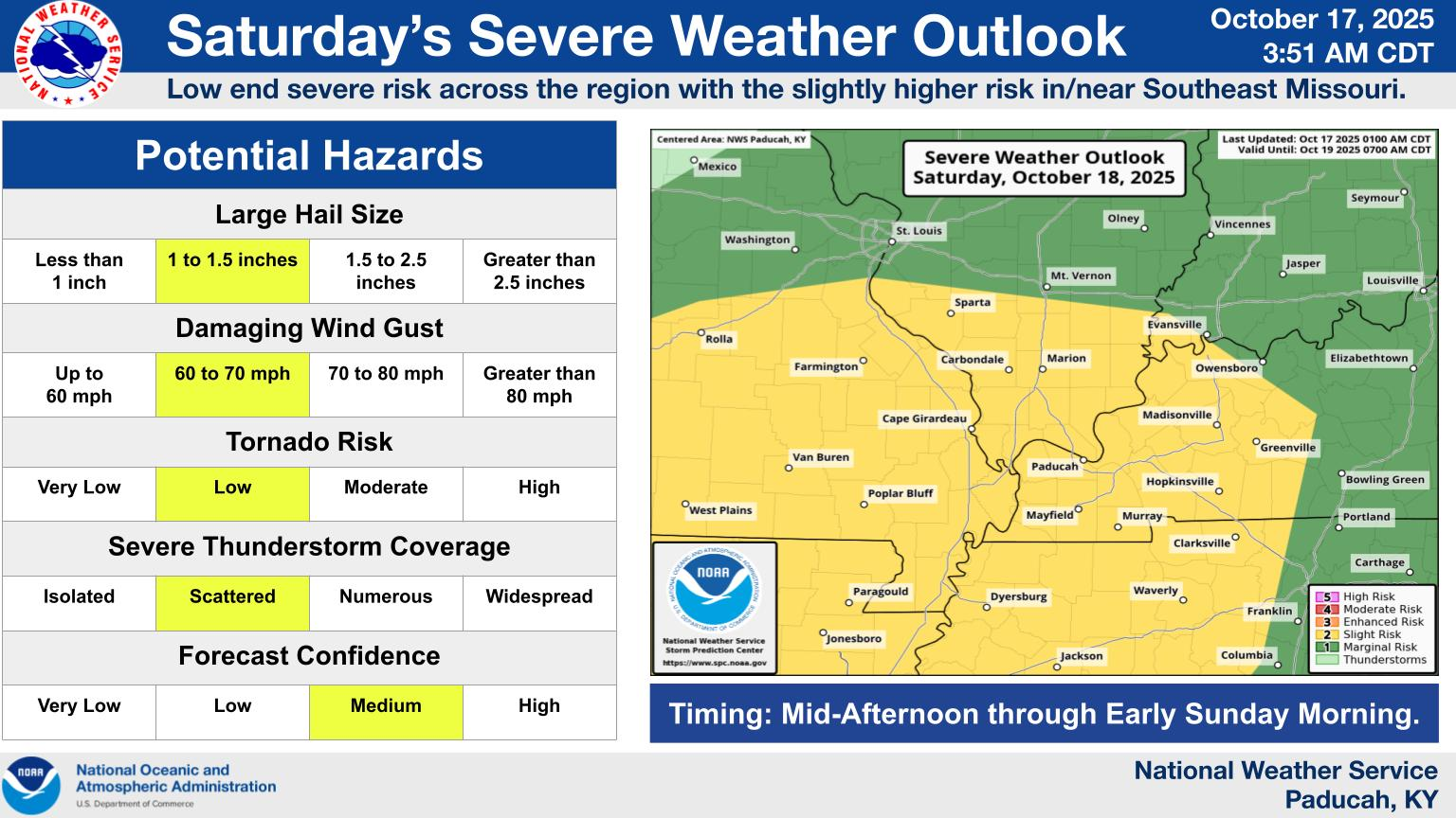
I continue to monitor the risk of a few storms becoming severe with sixty mph wind gusts, quarter-sized hail, and even a short-lived tornado.
At this time, the Storm Prediction Center has outlined our region for a risk of severe thunderstorms on Saturday afternoon and night.
Here is their latest outlook. They did shift it around a bit. That is not uncommon. Additional adjustments are possible as new data arrives today.
This graphic is from the Paducah, Kentucky, NWS.
.
Rainfall totals will vary. As they usually do. Generally, we are looking for 0.70″ to 1.40″. Thunderstorms can always enhance rain totals.
.
A few showers may linger into Sunday morning. It will turn cooler on Sunday.
A couple of showers are possible Monday night and Tuesday. A slight chance of a rumble of thunder, as well. We are not anticipating severe weather.

.
The timestamp (upper left) is in Zulu. 12z=7 am. 18z=1 pm. 00z=7 pm.
Double-click the animation to enlarge it.
RRFS model
.
The timestamp (upper left) is in Zulu. 12z=7 am. 18z=1 pm. 00z=7 pm.
Double-click the animation to enlarge it.
Hrrr model
.
..
.
Click here if you would like to return to the top of the page.
.Average high temperatures for this time of the year are around 75 degrees.
Average low temperatures for this time of the year are around 50 degrees.
Average precipitation during this time period ranges from 1.00″ to 1.25″
Six to Ten Day Outlook.
Blue is below average. Red is above average. The no color zone represents equal chances.
Average highs for this time of the year are in the lower 60s. Average lows for this time of the year are in the lower 40s.

Green is above average precipitation. Yellow and brown favors below average precipitation. Average precipitation for this time of the year is around one inch per week.

.

Average low temperatures for this time of the year are around 48 degrees.
Average precipitation during this time period ranges from 1.00″ to 1.25″
.
Eight to Fourteen Day Outlook.
Blue is below average. Red is above average. The no color zone represents equal chances.

Green is above average precipitation. Yellow and brown favors below average precipitation. Average precipitation for this time of the year is around one inch per week.

.
.
.
We have a new service to complement your www.weathertalk.com subscription. This does NOTreplace www.weathertalk.com It is simply another tool for you to receive severe weather information.
.
https://weathercallservices.com/beau-dodson-weather


Want to receive the daily forecast/other products on your Beau Dodson Weather app?
Did you know you have four options in your www.weathertalk.com account
You will then receive these via your Beau Dodson Weather app.
Just log into your www.weathertalk.com account
Click the NOTIFICATION SETTINGS TAB
Then, turn them on (green) and off (red)
🌪️ Number 1 is the most important one. Severe alerts, tornado alerts, and so on.
Number 2 is the daily video, blog, livestream alerts, and severe weather Facebook threads on severe days or winter storm days.
Number 3 is the daily forecast. I send that out every day during the afternoon hours. It is the seven-day forecast, hazardous weather outlook, fire outlook, and more.
Number 4 is to receive the daily video, blog, and other content on NON-severe weather days (every day without severe threats in other words)
GREEN IS ON
RED IS OFF

I am going to start going live during bigger severe weather events.
Check it out here https://www.youtube.com/user/beaudodson
Click the subscribe button (it’s a free subscription button), and it will alert you when I go live. I will also send out alerts to the app when I go live for an event.

.

Radars and Lightning Data
Interactive-city-view radars. Clickable watches and warnings.
https://wtalk.co/B3XHASFZ
Old legacy radar site (some of you like it better)
https://weatherobservatory.com/weather-radar.htm
If the radar is not updating then try another one. If a radar does not appear to be refreshing then hit Ctrl F5. You may also try restarting your browser.
Backup radar site in case the above one is not working.
https://weathertalk.com/morani
Regional Radar
https://imagery.weathertalk.com/prx/RadarLoop.mp4
** NEW ** Zoom radar with chaser tracking abilities!
ZoomRadar
If the radar is not working, then email me: Email me at beaudodson@usawx.com
.
We do have some sponsors! Check them out.
Roof damage from recent storms? Link – Click here
INTEGRITY ROOFING AND EXTERIORS!
⛈️ Roof or gutter damage from recent storms? Today’s weather is sponsored by Integrity Roofing. Check out their website at this link https://www.ourintegritymatters.com/

![]()
![]()
![]()
Make sure you have three to five ways of receiving your severe weather information.
Weather Talk is one of those ways! Now, I have another product for you and your family.

.
Want to add more products to your Beau Dodson Weather App?
Receive daily videos, weather blog updates on normal weather days and severe weather and winter storm days, your county by county weather forecast, and more!
Here is how to do add those additional products to your app notification settings!
Here is a video on how to update your Beau Dodson Weather payment.
The app is for subscribers. Subscribe at www.weathertalk.com/welcome then go to your app store and search for WeatherTalk
Subscribers, PLEASE USE THE APP. ATT and Verizon are not reliable during severe weather. They are delaying text messages.
The app is under WeatherTalk in the app store.

Apple users click here

Android users click here
.
Radars and Lightning Data
Interactive-city-view radars. Clickable watches and warnings.
https://wtalk.co/B3XHASFZ
Old legacy radar site (some of you like it better)
https://weatherobservatory.com/weather-radar.htm
If the radar is not updating then try another one. If a radar does not appear to be refreshing then hit Ctrl F5. You may also try restarting your browser.
Backup radar site in case the above one is not working.
https://weathertalk.com/morani
Regional Radar
https://imagery.weathertalk.com/prx/RadarLoop.mp4
** NEW ** Zoom radar with chaser tracking abilities!
ZoomRadar
Lightning Data (zoom in and out of your local area)
https://wtalk.co/WJ3SN5UZ
Not working? Email me at beaudodson@usawx.com
National map of weather watches and warnings. Click here.
Storm Prediction Center. Click here.
Weather Prediction Center. Click here.
.

Live lightning data: Click here.
Real time lightning data (another one) https://map.blitzortung.org/#5.02/37.95/-86.99
Our new Zoom radar with storm chases
.
.

Interactive GOES R satellite. Track clouds. Click here.
GOES 16 slider tool. Click here.
College of DuPage satellites. Click here
.

Here are the latest local river stage forecast numbers Click Here.
Here are the latest lake stage forecast numbers for Kentucky Lake and Lake Barkley Click Here.
.
.
Find Beau on Facebook! Click the banner.


 .
.