

.
I have some question-and-answer threads over on the Facebook page. Link to those threads CLICK HERE
Or email me at beaudodsonweather@gmail.com
..

🌪️ Seven-Day Tornado Outlook ⛈️
October 15th through October 21st
Current risk: MONITOR
Current confidence level: Medium confidence in the forecast.
Comments: I am monitoring the risk of severe weather on Saturday/Saturday night. The Storm Prediction Center does have us in a risk, but there remain questions on the extent of the severe threat. I will know quite a bit more tomorrow and Friday.
.

Seven-Day Hazardous Weather Outlook
1. Is lightning in the forecast? YES. There is a risk of lightning late Friday night into Saturday night.
2. Are organized/widespread severe thunderstorms in the forecast? MONITOR. Severe thunderstorms are possible on Saturday and Saturday night.
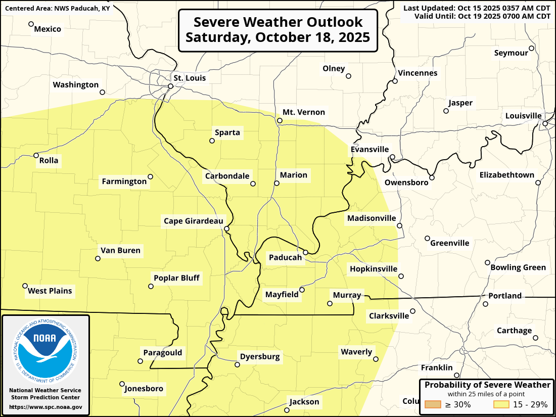
The Storm Prediction Center has placed our region in a level two out of five risk for Saturday/Saturday night.
There remain questions about instability. The greater threat may remain to our south.
Bottom line: Monitor updated forecasts. I will know more tomorrow and Friday. That is when the high-resolution guidance will become available.
Here is the area the SPC has outlined for a severe weather risk on Saturday/Saturday night.
The yellow zone is the level two risk. Adjustments in this are still possible.
.
3. Is significant or widespread flash flooding in the forecast? NO.
4. Will non-thunderstorm winds top 40 mph? NO. Gusty winds are possible on Friday and Saturday. At this time, it appears non-thunderstorm winds will remain below 40 mph.
5. Will temperatures rise above 90 degrees? NO.
6. Will the temperature fall below 32 degrees? NO.
7. Is a killing frost in the forecast? NO.
8. Is accumulating snow or ice in the forecast? NO.
.
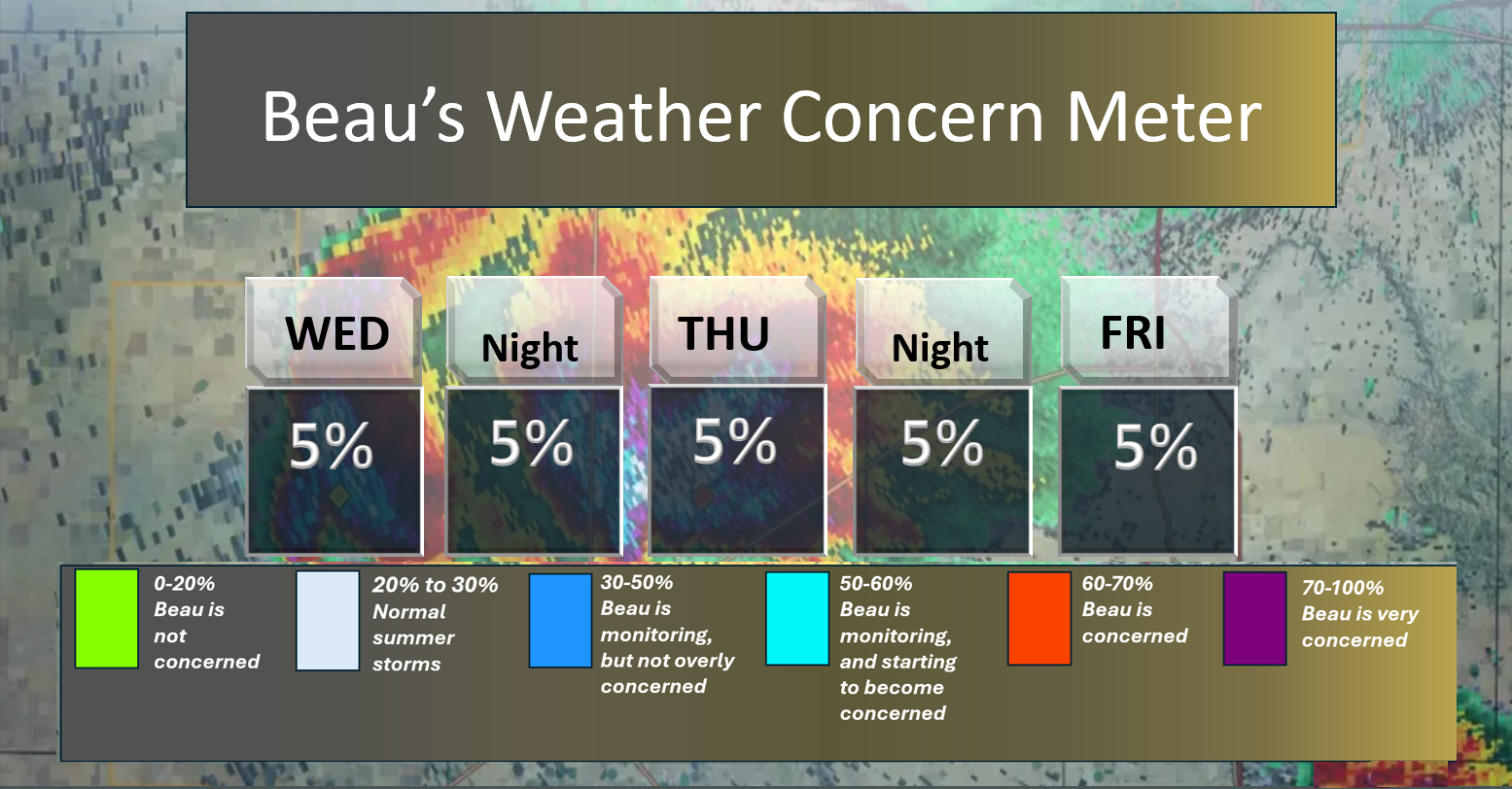
Here is the short-range concern meter.
.
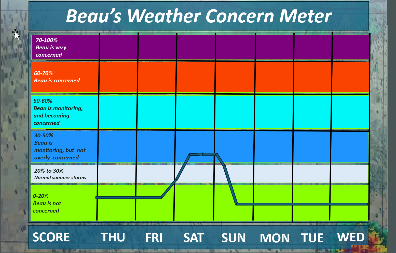
Here is the extended concern meter. This takes us through next Wednesday.
We pop into the blue on Saturday. There could be some severe thunderstorms, but questions remain on instability and timing.
For now, I am monitoring trends. Monitor updates over the coming days. There is plenty of time to monitor that portion of the forecast.
.
A quick forecast glance. Your 48-hour forecast Graphics


.
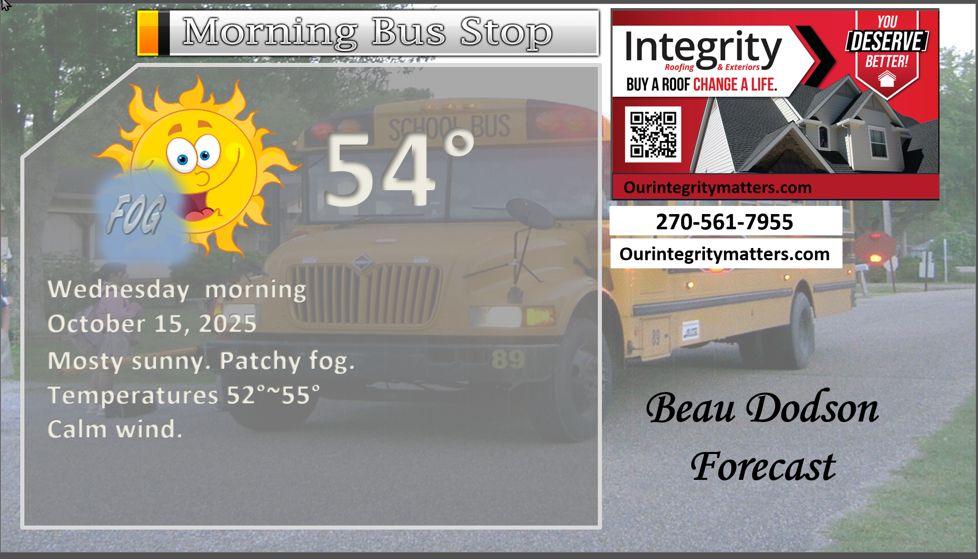
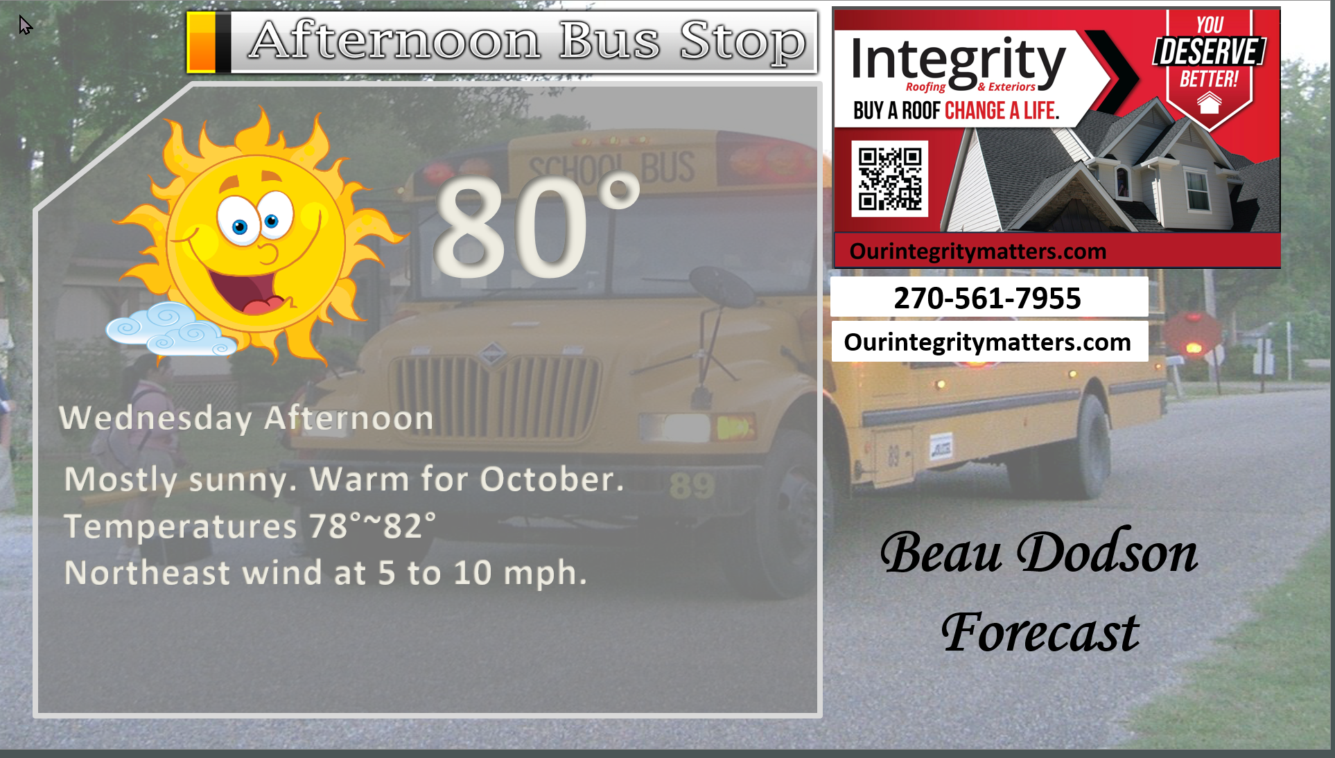
Here is your bus stop forecast.
.
This afternoon
.


Forecast discussion
- Warm conditions this week. Well above-average temperatures.
- Shower and thunderstorm chances will increase late Friday night into Saturday night. Tapering Saturday night/Sunday morning.
- If you have outdoor plans on Saturday, then plan on scattered to numerous showers and thunderstorms. I am still monitoring the timing, but it does appear the higher rain probabilities will be during the day on Saturday into Saturday night.
- Some of the thunderstorms could be intense on Saturday/Saturday night. Monitor updates.
.
 .
.
.
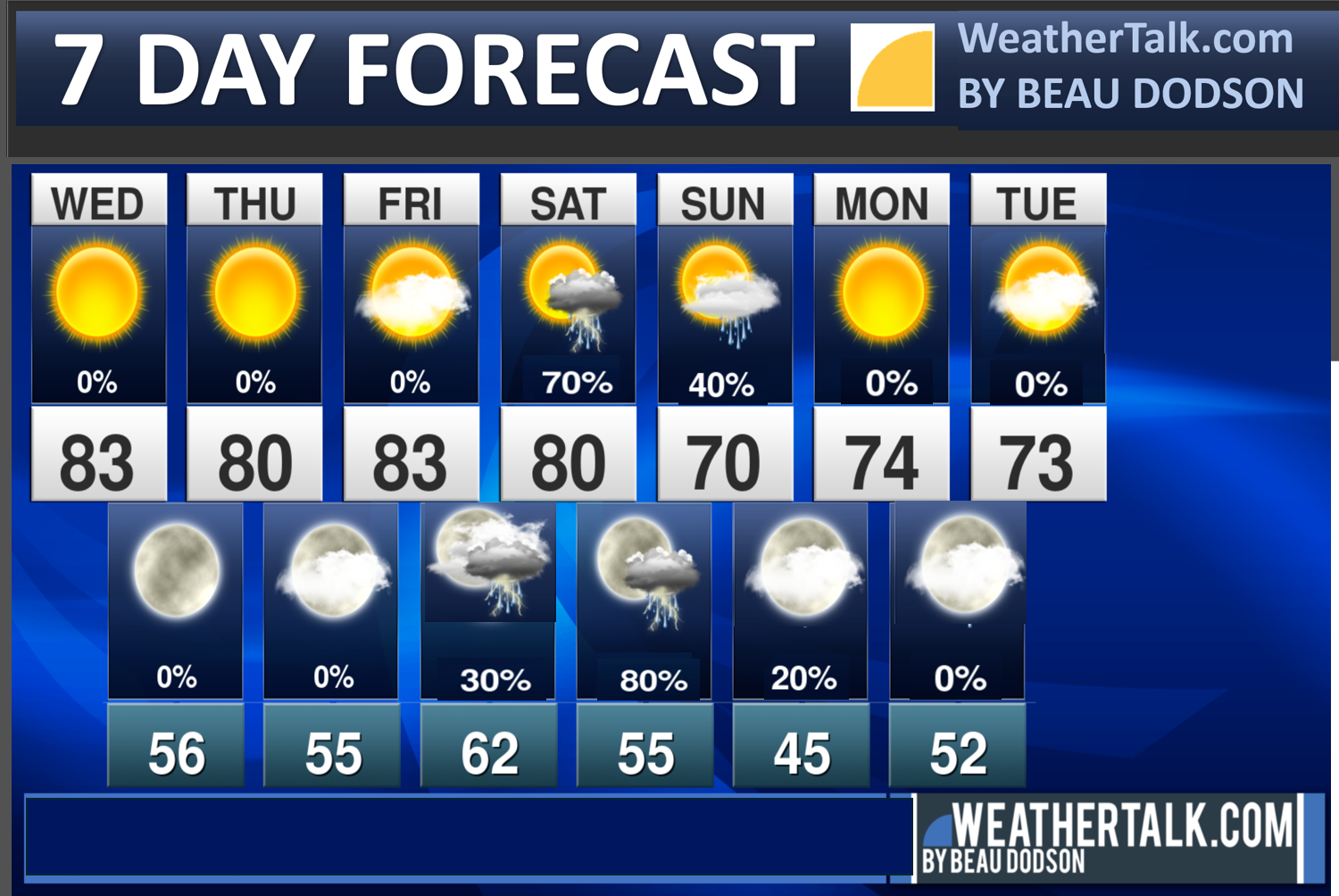
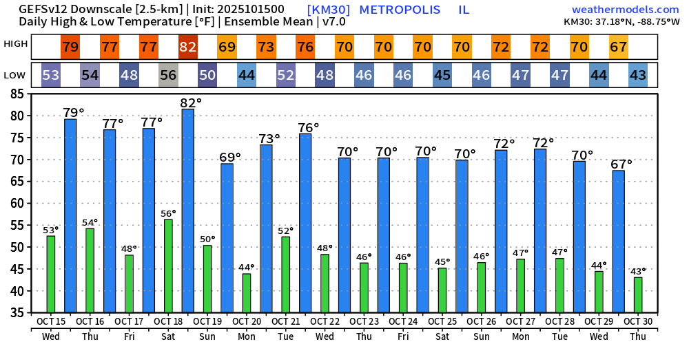
Seven-day outlook graphic.
.
Good morning, everyone.
Bottom line: If you have outdoor plans on Saturday and Saturday night, then carry an umbrella and a rain jacket. Then, if it rains, you will be prepared. The rain may hold off until Saturday evening/night, but that remains a question.
For now, plan on showers and thunderstorms dotting the weather radars during the day and night.
I know there are many outdoor events on Saturday, so we will hope for the best!
I did not make any major adjustments to the going forecast.
Once again, we have some nice days ahead of us. Warm.
Temperatures will be well above average today through Saturday. That equals highs in the upper 70s to lower 80s through Thursday. Then, low to mid-80s on Friday.
No significant weather concerns through Friday afternoon.
There could be some patchy fog at night. This is especially true near bodies of water and in valleys.
A strong cold front will approach the region on Saturday. This front will bring warm temperatures, increasing humidity levels, higher dew points, and showers/thunderstorms.
There remain some questions on what time it will rain at locations X, Y, and Z.
Data has slowed slightly over the past 24 hours.
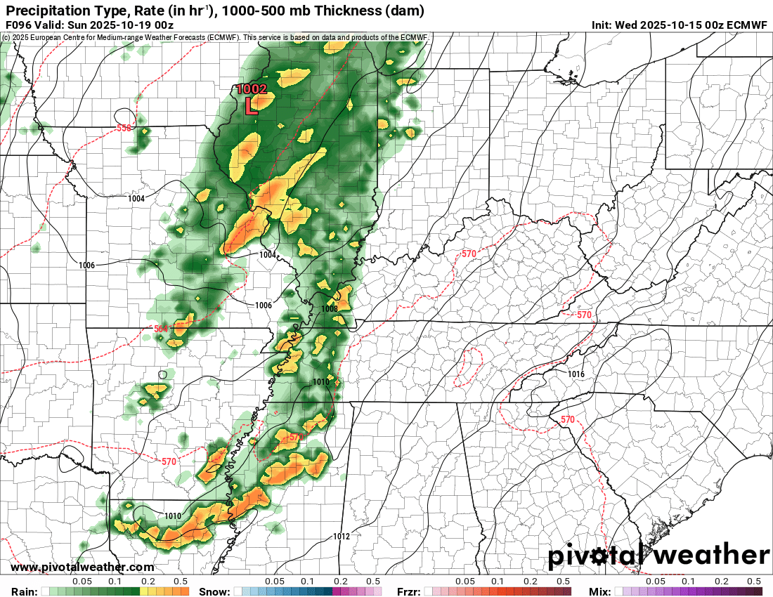
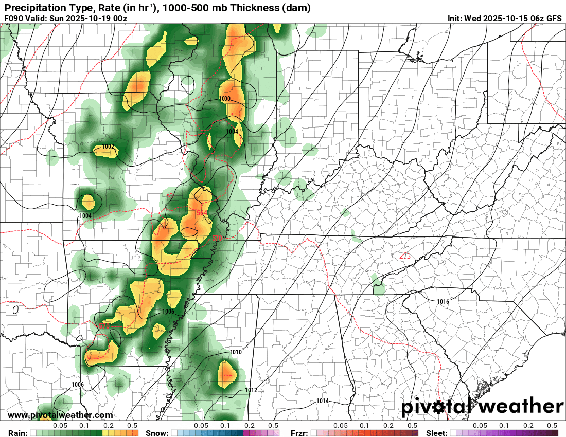
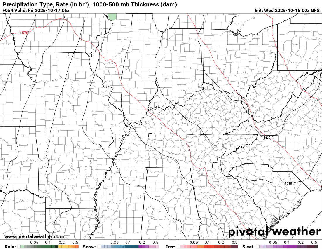
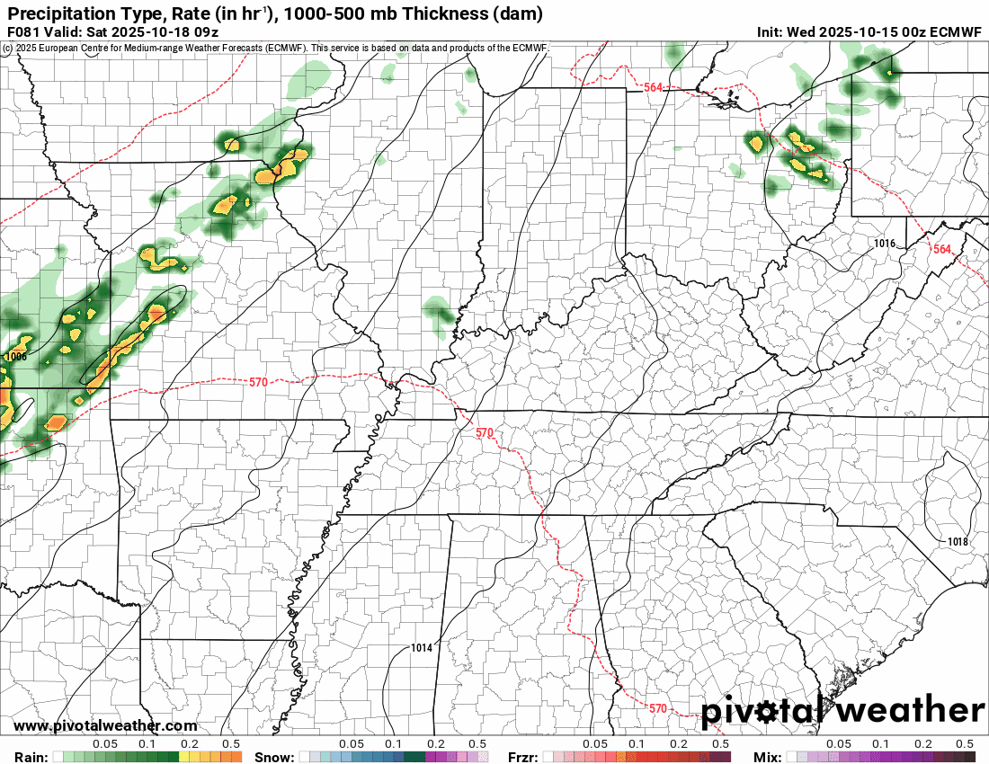
The EC model has always been the slowest model. It brings the front into the region on Saturday night. The GFS model has always been faster.
Here are the two model runs from this morning.
They are similar. Perhaps they are zeroing in on a solution.
Keep in mind, there could be scattered showers and thunderstorms from Saturday morning into Saturday afternoon. Then, the primary cold front will bring a band of showers and thunderstorms Saturday evening/night.
EC model. 7 PM Saturday. Future-cast radar.
.
GFS model. 7 PM Saturday. Future-cast radar.
.
I continue to monitor the risk of a few storms being intense.
At this time, the Storm Prediction Center has outlined our region for a risk of severe thunderstorms on Saturday.
There remain some questions about this event. Instability may be lacking for widespread severe weather. The higher instability levels may stay to our south.
Current data indicate a low-end severe weather risk. At this time, the tornado risk appears low.
We are still three to four days away from this event.
Confidence in the final forecast outcome will increase on Thursday and Friday. By then, we will have a decent idea of how the setup will unfold.
As mentioned, it likely won’t rain all day on Saturday, but there will be showers and thunderstorms dotting the weather radar throughout the day and night.
A few showers may remain in the region on Sunday. It will turn cooler behind the cold front.
Some days next week may remain in the sixties for highs. Highs in the seventies are a lock. That will feel a bit more like autumn.
I do not have any frost or freeze conditions in the seven-day forecast. A few locations may dip into the upper 30s next week. For now, I kept temperatures in the forties for lows. Locations that tend to be a bit colder on clear nights could dip below forty degrees.
Let’s look at the long-range model ensemble temperatures means.
This is the GFS ensembles. The mean/average temperatures. Highs and lows.
.

.
The timestamp (upper left) is in Zulu. 12z=7 am. 18z=1 pm. 00z=7 pm.
Double-click the animation to enlarge it.
GFS model
.
The timestamp (upper left) is in Zulu. 12z=7 am. 18z=1 pm. 00z=7 pm.
Double-click the animation to enlarge it.
EC model
.
..
.
Click here if you would like to return to the top of the page.
.Average high temperatures for this time of the year are around 75 degrees.
Average low temperatures for this time of the year are around 50 degrees.
Average precipitation during this time period ranges from 1.00″ to 1.25″
Six to Ten Day Outlook.
Blue is below average. Red is above average. The no color zone represents equal chances.
Average highs for this time of the year are in the lower 60s. Average lows for this time of the year are in the lower 40s.

Green is above average precipitation. Yellow and brown favors below average precipitation. Average precipitation for this time of the year is around one inch per week.

.

Average low temperatures for this time of the year are around 48 degrees.
Average precipitation during this time period ranges from 1.00″ to 1.25″
.
Eight to Fourteen Day Outlook.
Blue is below average. Red is above average. The no color zone represents equal chances.

Green is above average precipitation. Yellow and brown favors below average precipitation. Average precipitation for this time of the year is around one inch per week.

.
.
.
We have a new service to complement your www.weathertalk.com subscription. This does NOTreplace www.weathertalk.com It is simply another tool for you to receive severe weather information.
.
https://weathercallservices.com/beau-dodson-weather


Want to receive the daily forecast/other products on your Beau Dodson Weather app?
Did you know you have four options in your www.weathertalk.com account
You will then receive these via your Beau Dodson Weather app.
Just log into your www.weathertalk.com account
Click the NOTIFICATION SETTINGS TAB
Then, turn them on (green) and off (red)
🌪️ Number 1 is the most important one. Severe alerts, tornado alerts, and so on.
Number 2 is the daily video, blog, livestream alerts, and severe weather Facebook threads on severe days or winter storm days.
Number 3 is the daily forecast. I send that out every day during the afternoon hours. It is the seven-day forecast, hazardous weather outlook, fire outlook, and more.
Number 4 is to receive the daily video, blog, and other content on NON-severe weather days (every day without severe threats in other words)
GREEN IS ON
RED IS OFF

I am going to start going live during bigger severe weather events.
Check it out here https://www.youtube.com/user/beaudodson
Click the subscribe button (it’s a free subscription button), and it will alert you when I go live. I will also send out alerts to the app when I go live for an event.

.

Radars and Lightning Data
Interactive-city-view radars. Clickable watches and warnings.
https://wtalk.co/B3XHASFZ
Old legacy radar site (some of you like it better)
https://weatherobservatory.com/weather-radar.htm
If the radar is not updating then try another one. If a radar does not appear to be refreshing then hit Ctrl F5. You may also try restarting your browser.
Backup radar site in case the above one is not working.
https://weathertalk.com/morani
Regional Radar
https://imagery.weathertalk.com/prx/RadarLoop.mp4
** NEW ** Zoom radar with chaser tracking abilities!
ZoomRadar
If the radar is not working, then email me: Email me at beaudodson@usawx.com
.
We do have some sponsors! Check them out.
Roof damage from recent storms? Link – Click here
INTEGRITY ROOFING AND EXTERIORS!
⛈️ Roof or gutter damage from recent storms? Today’s weather is sponsored by Integrity Roofing. Check out their website at this link https://www.ourintegritymatters.com/

![]()
![]()
![]()
Make sure you have three to five ways of receiving your severe weather information.
Weather Talk is one of those ways! Now, I have another product for you and your family.

.
Want to add more products to your Beau Dodson Weather App?
Receive daily videos, weather blog updates on normal weather days and severe weather and winter storm days, your county by county weather forecast, and more!
Here is how to do add those additional products to your app notification settings!
Here is a video on how to update your Beau Dodson Weather payment.
The app is for subscribers. Subscribe at www.weathertalk.com/welcome then go to your app store and search for WeatherTalk
Subscribers, PLEASE USE THE APP. ATT and Verizon are not reliable during severe weather. They are delaying text messages.
The app is under WeatherTalk in the app store.

Apple users click here

Android users click here
.
Radars and Lightning Data
Interactive-city-view radars. Clickable watches and warnings.
https://wtalk.co/B3XHASFZ
Old legacy radar site (some of you like it better)
https://weatherobservatory.com/weather-radar.htm
If the radar is not updating then try another one. If a radar does not appear to be refreshing then hit Ctrl F5. You may also try restarting your browser.
Backup radar site in case the above one is not working.
https://weathertalk.com/morani
Regional Radar
https://imagery.weathertalk.com/prx/RadarLoop.mp4
** NEW ** Zoom radar with chaser tracking abilities!
ZoomRadar
Lightning Data (zoom in and out of your local area)
https://wtalk.co/WJ3SN5UZ
Not working? Email me at beaudodson@usawx.com
National map of weather watches and warnings. Click here.
Storm Prediction Center. Click here.
Weather Prediction Center. Click here.
.

Live lightning data: Click here.
Real time lightning data (another one) https://map.blitzortung.org/#5.02/37.95/-86.99
Our new Zoom radar with storm chases
.
.

Interactive GOES R satellite. Track clouds. Click here.
GOES 16 slider tool. Click here.
College of DuPage satellites. Click here
.

Here are the latest local river stage forecast numbers Click Here.
Here are the latest lake stage forecast numbers for Kentucky Lake and Lake Barkley Click Here.
.
.
Find Beau on Facebook! Click the banner.


 .
.