

.
I have some question-and-answer threads over on the Facebook page. Link to those threads CLICK HERE
Or email me at beaudodsonweather@gmail.com
..

🌪️ Seven-Day Tornado Outlook ⛈️
October 7th through October 13th
Current risk: NO
Current confidence level: High confidence in the forecast.
Comments: Tornadoes are not in the forecast.
.

Seven-Day Hazardous Weather Outlook
1. Is lightning in the forecast? YES. Lightning is possible today.
2. Are organized/widespread severe thunderstorms in the forecast? NO.
3. Is flash flooding in the forecast? SCATTERED. Some flash flooding issues are possible today. Locally heavy rain across portions of the region (see below). This could cause flooding of ditches, roadways, and streams. Avoid flooded roadways if flooding develops in some counties.
4. Will non-thunderstorm winds top 40 mph? NO.
5. Will temperatures rise above 90 degrees? NO.
6. Will temperatures rise above 100 degrees? NO.
7. Will the heat index (feels like) rise above 100 degrees? NO.
8. Will the heat index rise above 115 degrees? NO.
9. Will the temperature fall below 32 degrees? NO.
.

Radars and Lightning Data
Interactive-city-view radars. Clickable watches and warnings.
https://wtalk.co/B3XHASFZ
Old legacy radar site (some of you like it better)
https://weatherobservatory.com/weather-radar.htm
If the radar is not updating then try another one. If a radar does not appear to be refreshing then hit Ctrl F5. You may also try restarting your browser.
Backup radar site in case the above one is not working.
https://weathertalk.com/morani
Regional Radar
https://imagery.weathertalk.com/prx/RadarLoop.mp4
** NEW ** Zoom radar with chaser tracking abilities!
ZoomRadar
Lightning Data (zoom in and out of your local area)
https://wtalk.co/WJ3SN5UZ
Not working? Email me at beaudodson@usawx.com
.
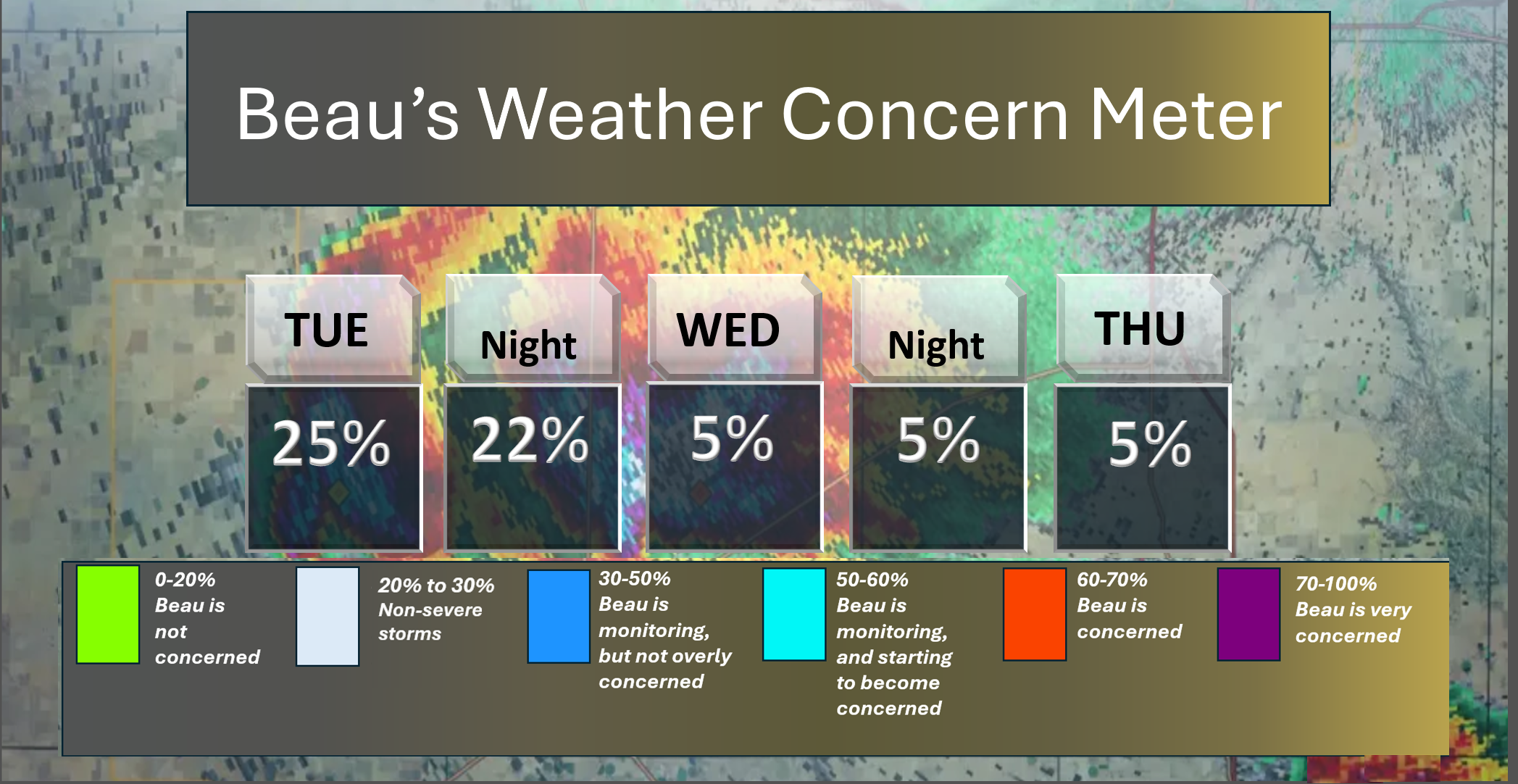
Here is the short-range concern meter.
Lightning is possible today into Tuesday evening.
.
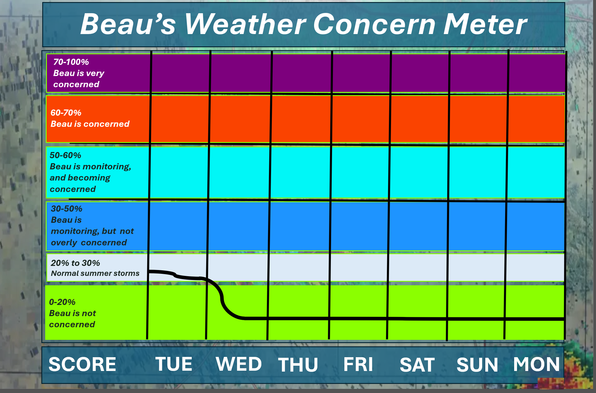
Here is the extended concern meter. This takes us through next Monday.
I did place us in grey today. That is for lightning and locally heavy rainfall.
.
A quick forecast glance. Your 48-hour forecast Graphics


.
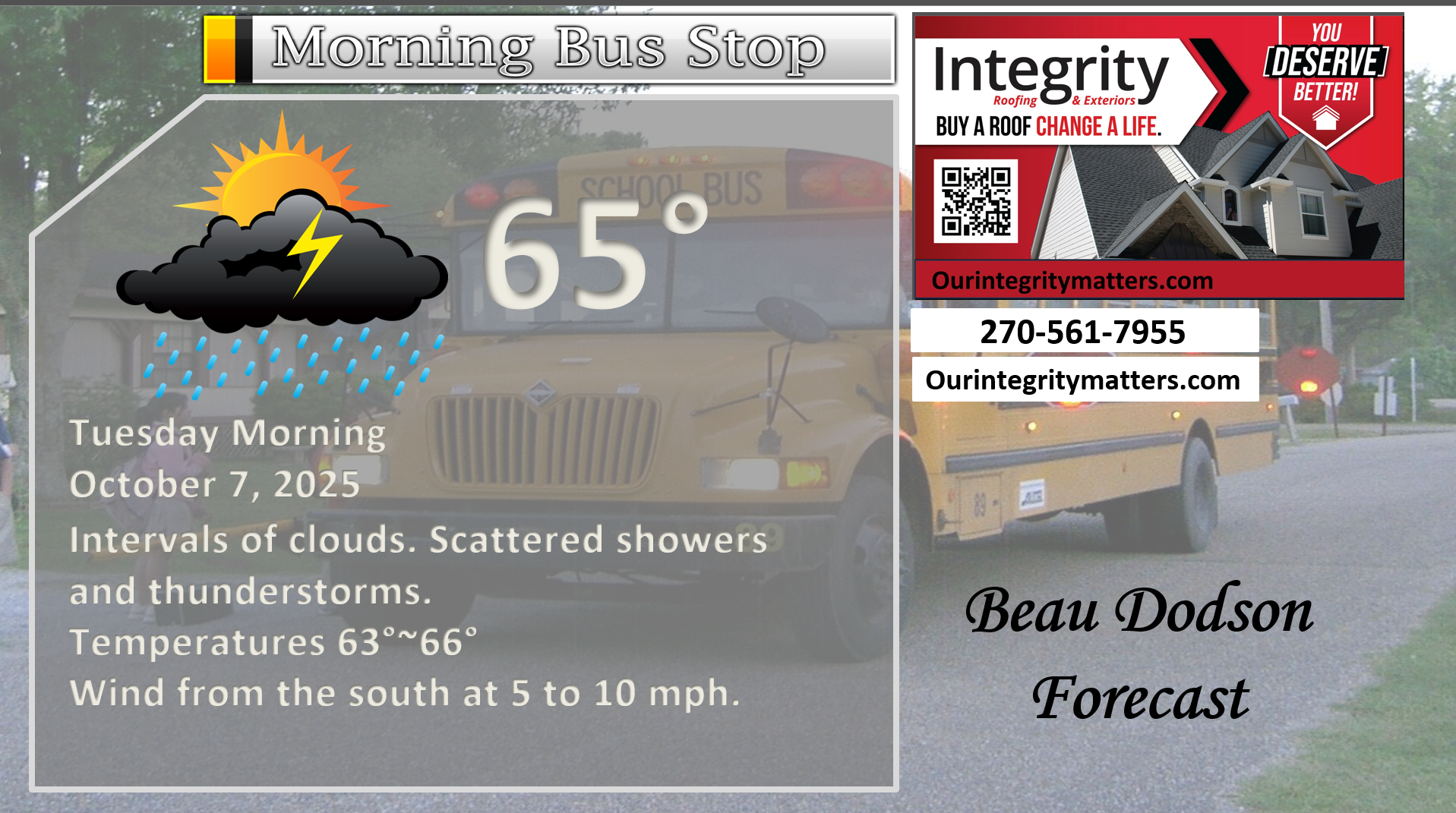
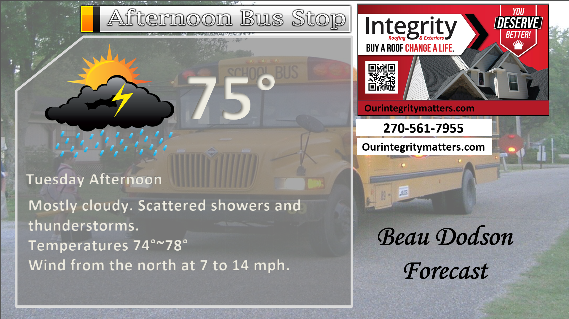
Here is your bus stop forecast.
.
This afternoon
.


Forecast discussion
- Showers and thunderstorms today. Tapering off from northwest to southeast later today.
- Locally heavy downpours.
- Cooler temperatures today.
- Nicer conditions from Wednesday through Sunday. It is expected to be dry during that time frame.
- I am watching another front around next Monday. Perhaps some more showers with it.
.
 .
.
.
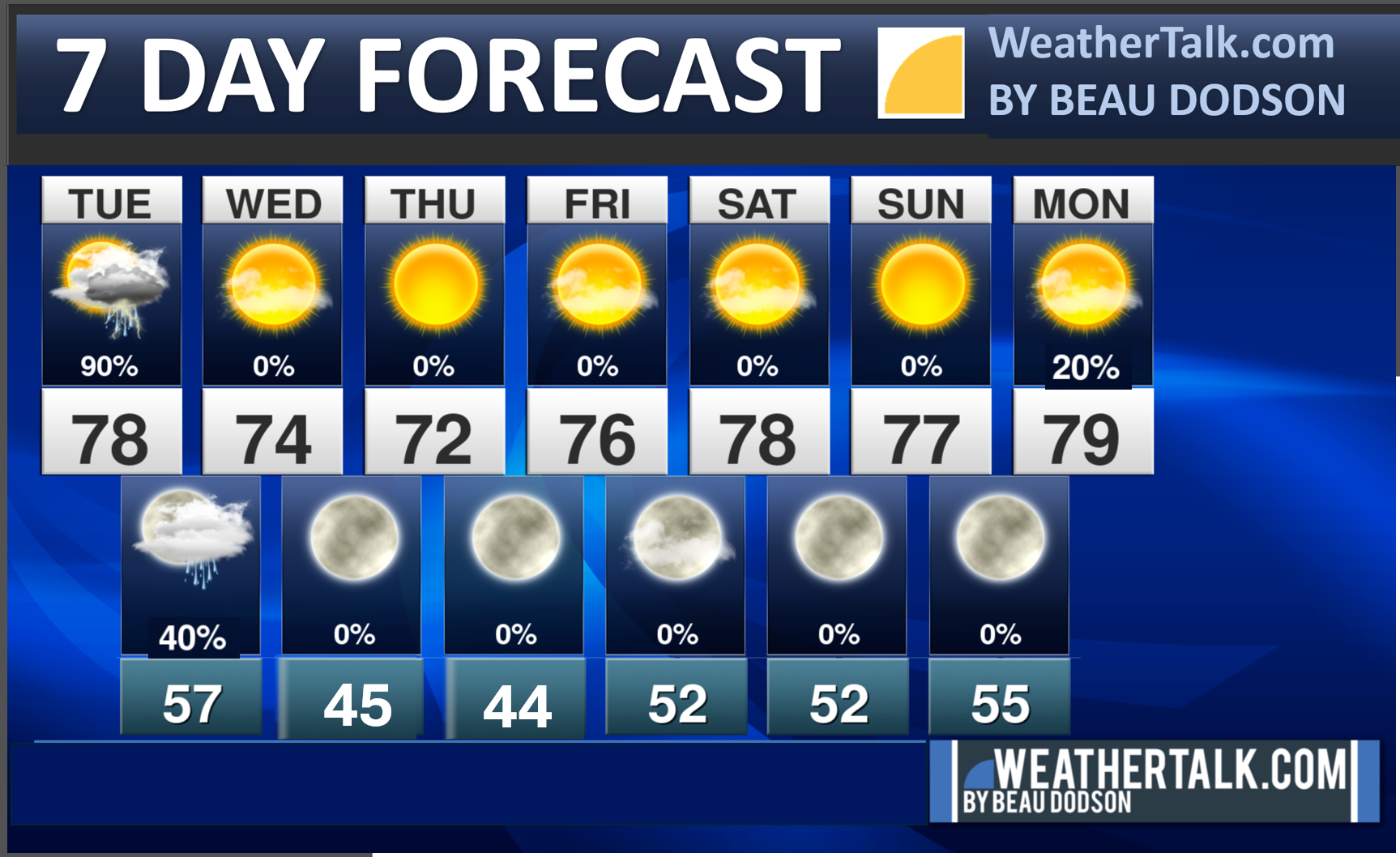
Seven-day outlook graphic.
.
Good day, everyone! The rain has arrived.
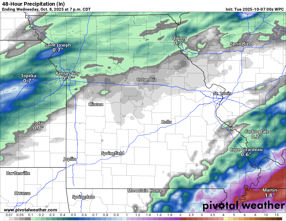
Some locations have already picked up over an inch of much-needed rainfall.
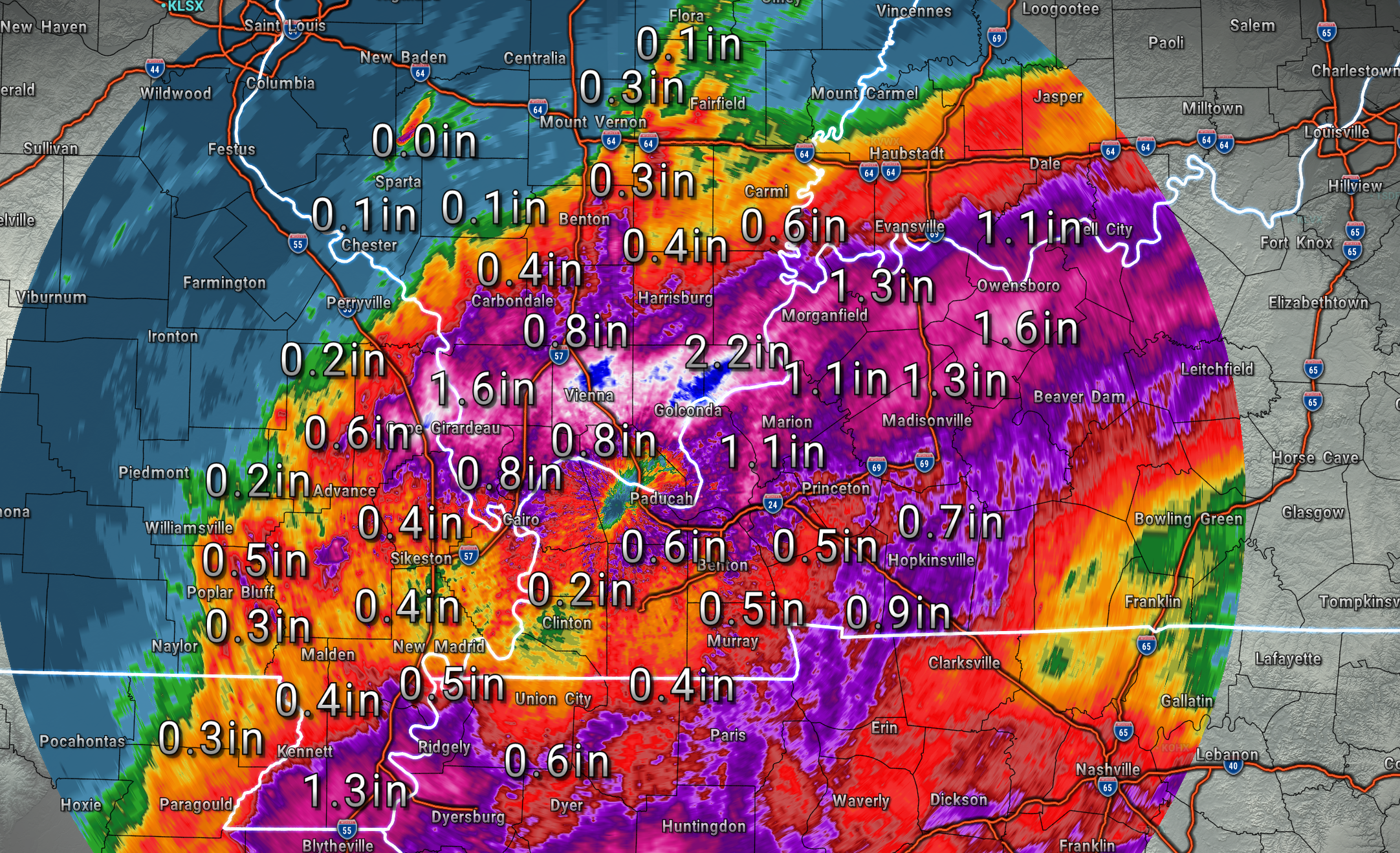
Here are the radar-estimated rainfall totals as of 5 AM on Tuesday.
Notice the sharp cut-off over my western and northwestern counties. Some locations have received very little rainfall. That was anticipated.
There is a wide range of totals. That seems to be the case around here most of the time.
This is what radar looked like at 5:30 AM
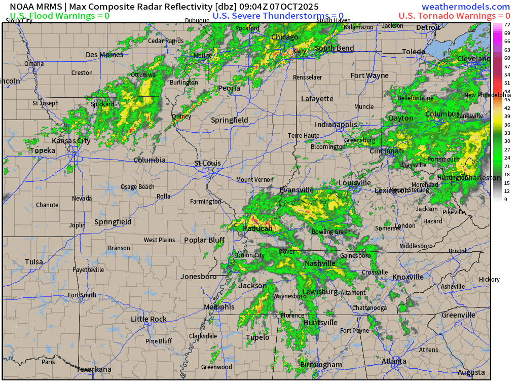
We will have numerous showers and thunderstorms on the radar today. The shower and thunderstorm activity will taper from northwest to southeast as we move through the afternoon and evening hours. Coming to an end overnight.
Locally heavy downpours are likely.
An additional 0.40″ to 0.80″ of rain is likely across most of the region, perhaps a bit lower from Butler County, Missouri, north to Ste. Genevieve County, Missouri, and then east to Jefferson County, Illinois.
Locally, totals are expected to exceed an inch today.
When all is said and done, much of the region will have received an inch or two of rain. Then, local spots will exceed those amounts. That is more likely when showers and thunderstorms repeatedly train over the same areas.
The locally heavy rain could cause flooding of ditches and roadways. Mainly, the commonly flooded areas.
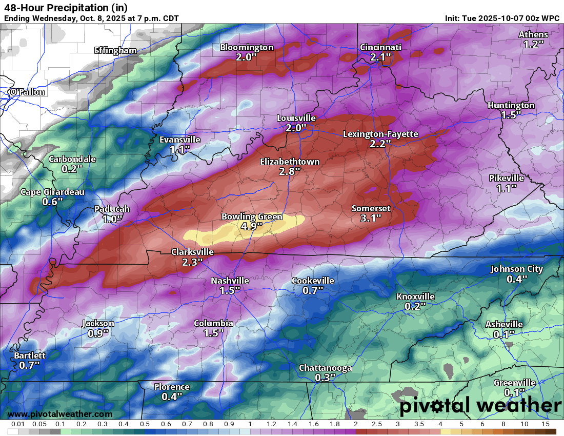
Here are the latest rainfall forecast numbers.
Notice the sharp gradient over my northwestern counties.
Ohio Valley view
Missouri View
.
Severe weather is not anticipated; however, storms are expected to produce lightning and downpours.
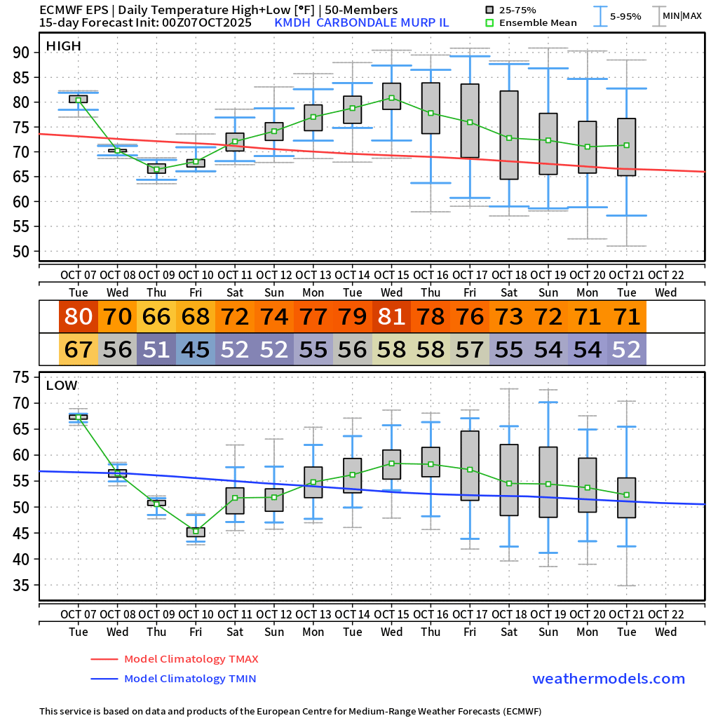
The cold front will push across the region today and tonight. This will usher in cooler temperatures.
Highs will be in the 70s later this week. Overnight lows will dip into the 40s and lower 50s. It might actually feel like autumn outside!
I can’t rule out some lows in the thirties in cold-weather spots. That would be on Wednesday and Thursday night.
Let’s take a look at the ensemble temperature forecast. This is the mean of 100 models.
As you can see, temperatures will be lower than they have been in recent weeks.
Average highs for this time of the year are around the 76 to 78 degree range. Average low temperatures are in the lower 50s.

.
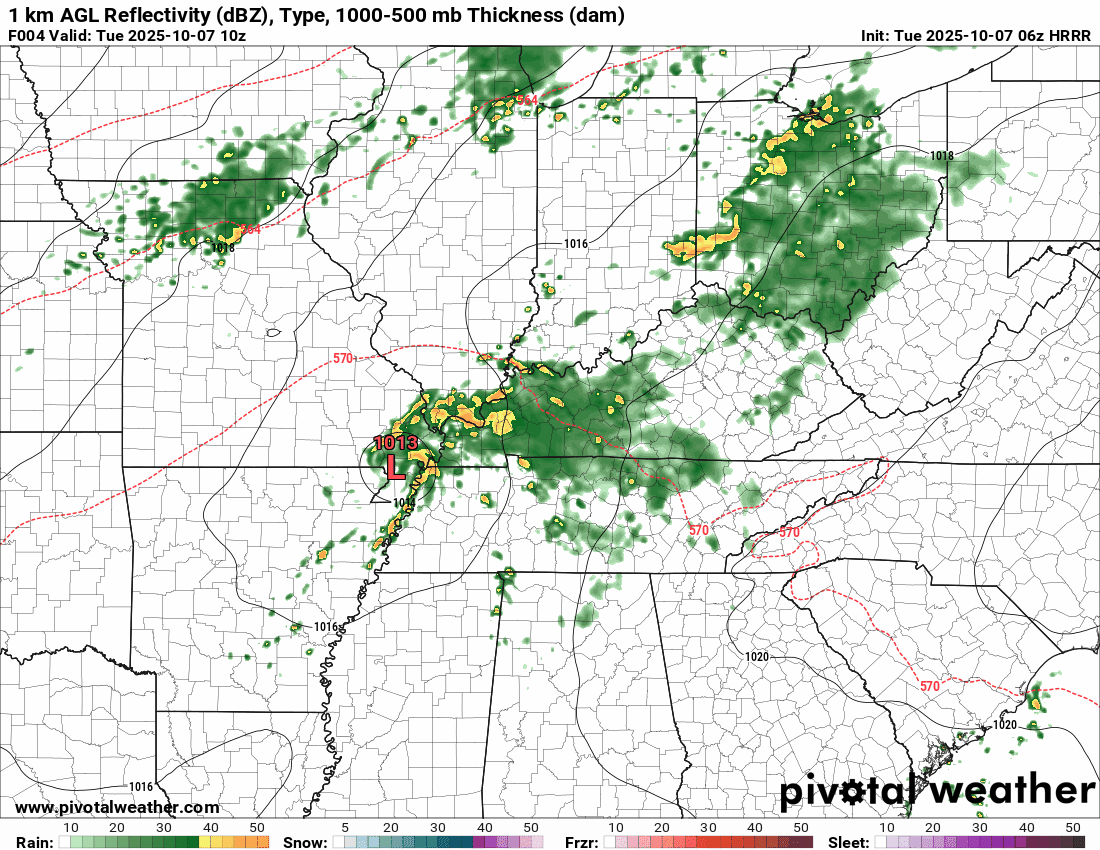
The timestamp (upper left) is in Zulu. 12z=7 am. 18z=1 pm. 00z=7 pm.
Double-click the animation to enlarge it.
Hrrr model
.
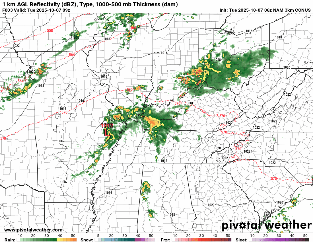
The timestamp (upper left) is in Zulu. 12z=7 am. 18z=1 pm. 00z=7 pm.
Double-click the animation to enlarge it.
NAM 3K model
.
..
.
Click here if you would like to return to the top of the page.
.Average high temperatures for this time of the year are around 78 degrees.
Average low temperatures for this time of the year are around 54 degrees.
Average precipitation during this time period ranges from 1.00″ to 1.25″
Six to Ten Day Outlook.
Blue is below average. Red is above average. The no color zone represents equal chances.
Average highs for this time of the year are in the lower 60s. Average lows for this time of the year are in the lower 40s.

Green is above average precipitation. Yellow and brown favors below average precipitation. Average precipitation for this time of the year is around one inch per week.

.

Average low temperatures for this time of the year are around 51 degrees.
Average precipitation during this time period ranges from 1.00″ to 1.25″
.
Eight to Fourteen Day Outlook.
Blue is below average. Red is above average. The no color zone represents equal chances.

Green is above average precipitation. Yellow and brown favors below average precipitation. Average precipitation for this time of the year is around one inch per week.

.
.
.
We have a new service to complement your www.weathertalk.com subscription. This does NOTreplace www.weathertalk.com It is simply another tool for you to receive severe weather information.
.
https://weathercallservices.com/beau-dodson-weather


Want to receive the daily forecast/other products on your Beau Dodson Weather app?
Did you know you have four options in your www.weathertalk.com account
You will then receive these via your Beau Dodson Weather app.
Just log into your www.weathertalk.com account
Click the NOTIFICATION SETTINGS TAB
Then, turn them on (green) and off (red)
🌪️ Number 1 is the most important one. Severe alerts, tornado alerts, and so on.
Number 2 is the daily video, blog, livestream alerts, and severe weather Facebook threads on severe days or winter storm days.
Number 3 is the daily forecast. I send that out every day during the afternoon hours. It is the seven-day forecast, hazardous weather outlook, fire outlook, and more.
Number 4 is to receive the daily video, blog, and other content on NON-severe weather days (every day without severe threats in other words)
GREEN IS ON
RED IS OFF

I am going to start going live during bigger severe weather events.
Check it out here https://www.youtube.com/user/beaudodson
Click the subscribe button (it’s a free subscription button), and it will alert you when I go live. I will also send out alerts to the app when I go live for an event.

.
Radars and Lightning Data
Interactive-city-view radars. Clickable watches and warnings.
https://wtalk.co/B3XHASFZ
Old legacy radar site (some of you like it better)
https://weatherobservatory.com/weather-radar.htm
If the radar is not updating then try another one. If a radar does not appear to be refreshing then hit Ctrl F5. You may also try restarting your browser.
Backup radar site in case the above one is not working.
https://weathertalk.com/morani
Regional Radar
https://imagery.weathertalk.com/prx/RadarLoop.mp4
** NEW ** Zoom radar with chaser tracking abilities!
ZoomRadar
If the radar is not working, then email me: Email me at beaudodson@usawx.com
.
We do have some sponsors! Check them out.
Roof damage from recent storms? Link – Click here
INTEGRITY ROOFING AND EXTERIORS!
⛈️ Roof or gutter damage from recent storms? Today’s weather is sponsored by Integrity Roofing. Check out their website at this link https://www.ourintegritymatters.com/

![]()
![]()
![]()
Make sure you have three to five ways of receiving your severe weather information.
Weather Talk is one of those ways! Now, I have another product for you and your family.

.
Want to add more products to your Beau Dodson Weather App?
Receive daily videos, weather blog updates on normal weather days and severe weather and winter storm days, your county by county weather forecast, and more!
Here is how to do add those additional products to your app notification settings!
Here is a video on how to update your Beau Dodson Weather payment.
The app is for subscribers. Subscribe at www.weathertalk.com/welcome then go to your app store and search for WeatherTalk
Subscribers, PLEASE USE THE APP. ATT and Verizon are not reliable during severe weather. They are delaying text messages.
The app is under WeatherTalk in the app store.

Apple users click here

Android users click here
.
Radars and Lightning Data
Interactive-city-view radars. Clickable watches and warnings.
https://wtalk.co/B3XHASFZ
Old legacy radar site (some of you like it better)
https://weatherobservatory.com/weather-radar.htm
If the radar is not updating then try another one. If a radar does not appear to be refreshing then hit Ctrl F5. You may also try restarting your browser.
Backup radar site in case the above one is not working.
https://weathertalk.com/morani
Regional Radar
https://imagery.weathertalk.com/prx/RadarLoop.mp4
** NEW ** Zoom radar with chaser tracking abilities!
ZoomRadar
Lightning Data (zoom in and out of your local area)
https://wtalk.co/WJ3SN5UZ
Not working? Email me at beaudodson@usawx.com
National map of weather watches and warnings. Click here.
Storm Prediction Center. Click here.
Weather Prediction Center. Click here.
.

Live lightning data: Click here.
Real time lightning data (another one) https://map.blitzortung.org/#5.02/37.95/-86.99
Our new Zoom radar with storm chases
.
.

Interactive GOES R satellite. Track clouds. Click here.
GOES 16 slider tool. Click here.
College of DuPage satellites. Click here
.

Here are the latest local river stage forecast numbers Click Here.
Here are the latest lake stage forecast numbers for Kentucky Lake and Lake Barkley Click Here.
.
.
Find Beau on Facebook! Click the banner.


 .
.