

.
I have some question-and-answer threads over on the Facebook page. Link to those threads CLICK HERE
Or email me at beaudodsonweather@gmail.com
..

🌪️ Seven-Day Tornado Outlook ⛈️
July 28th through August 3rd
Current risk: None.
Current confidence level: High confidence in the forecast.
Comment: No tornado threats.
.

Seven-Day Hazardous Weather Outlook
1. Is lightning in the forecast? YES. Scattered lightning is likely over the coming days. The lightning threat will continue through at least Thursday.
2. Are organized severe thunderstorms in the forecast? MONITOR. Thunderstorms, during the summer months, can produce isolated gusty winds. Organized severe weather is not anticipated.
A cold front will bring an increased risk of strong thunderstorms on Wednesday and Thursday. Some of the thunderstorms could produce high wind gusts. Monitor updates.
3. Is flash flooding in the forecast? ISOLATED. Slow-moving summer storms can produce torrential downpours that can briefly flood ditches and roadways. This will be a concern through at least Thursday.
4. Will non-thunderstorm winds top 40 mph? NO.
5. Will temperatures rise above 90 degrees? YES. Temperatures are expected to be in the nineties through at least Wednesday. Perhaps on Thursday in some locations. Thursday’s temperatures will depend on just how fast the cold front passes through the region.
6. Will temperatures rise above 100 degrees? NO.
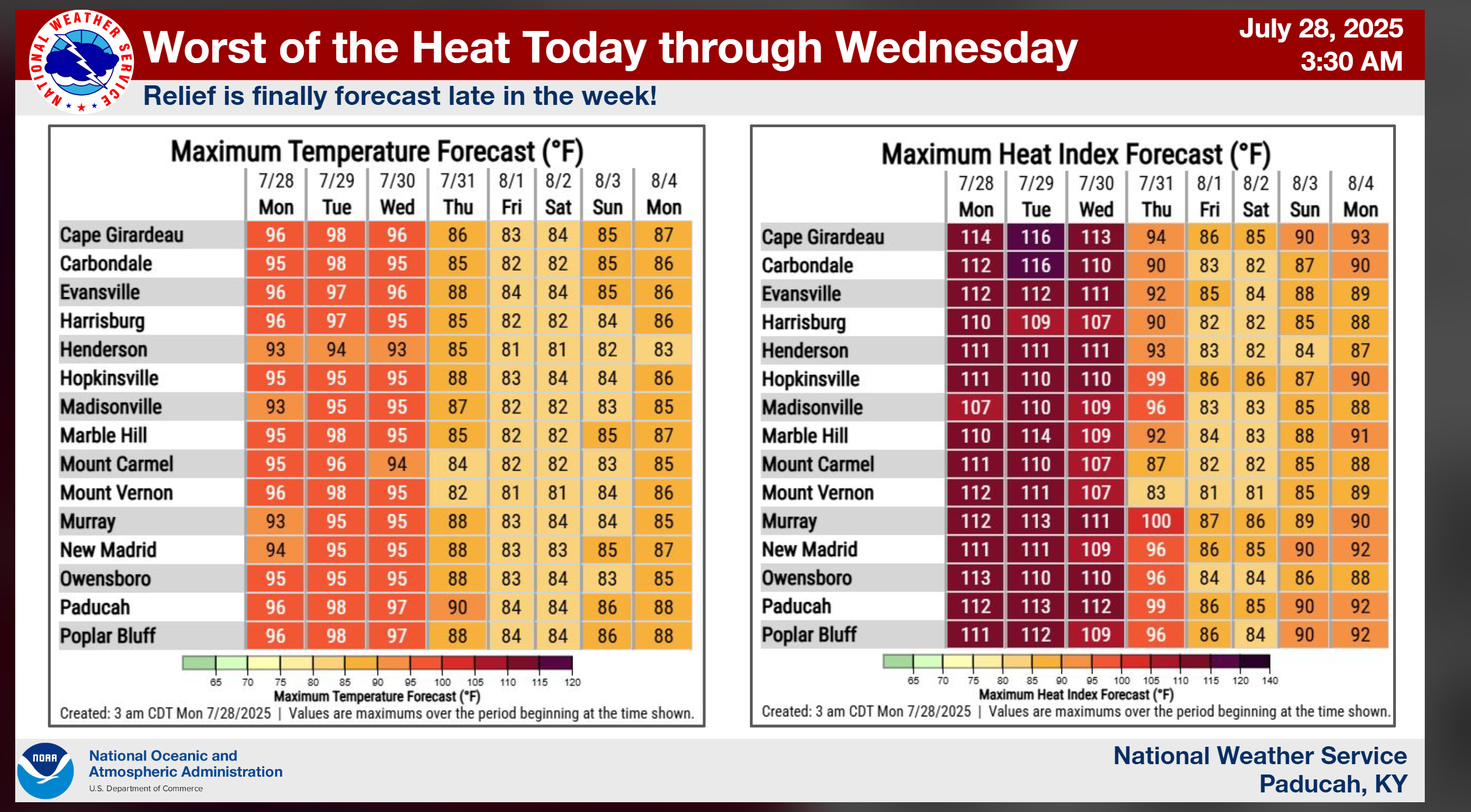
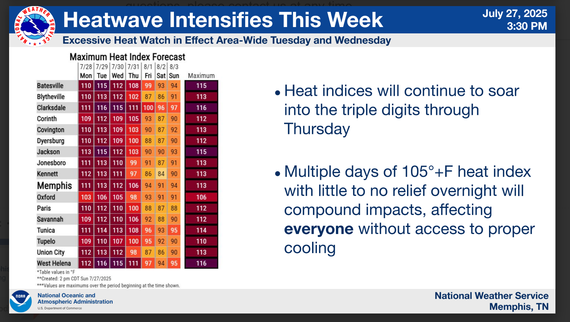
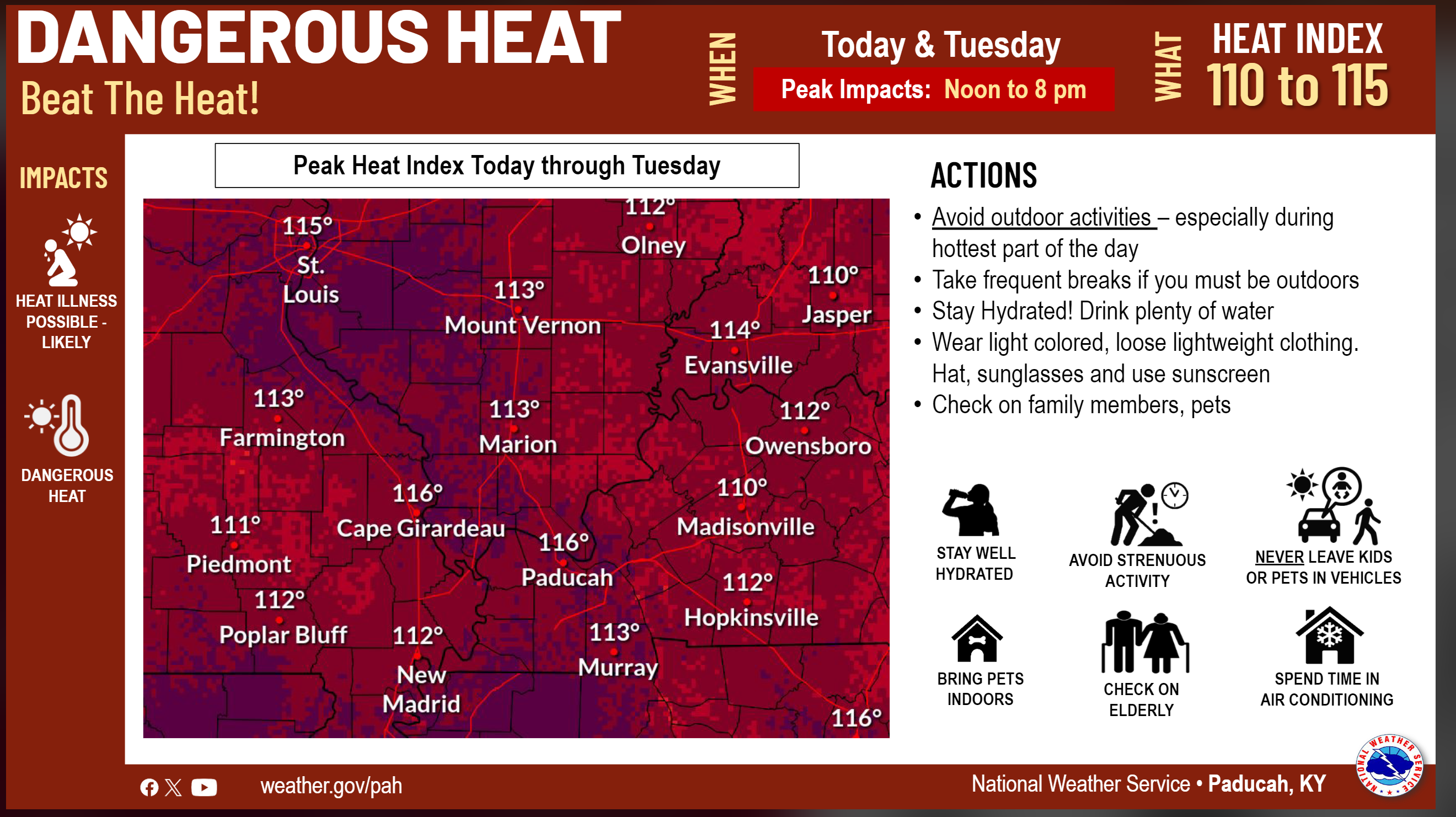
7. Will the heat index (feels like) rise above 100 degrees? YES. Heat index values of 108 to 116 degrees are expected to be in the forecast through Wednesday. Perhaps above 100 in some counties on Thursday (depending on how fast the front moves through the region).
8. Will the heat index rise above 115 degrees? POSSIBLE. It is possible, in some locations, today through Wednesday. Use care during the peak heating hours.
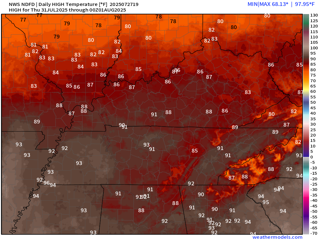
Here is a graphic that shows you high temperatures and heat index values. Find the city nearest to you.
Notice the warmest temperatures will arrive early next week.
Double-click on this image to enlarge.
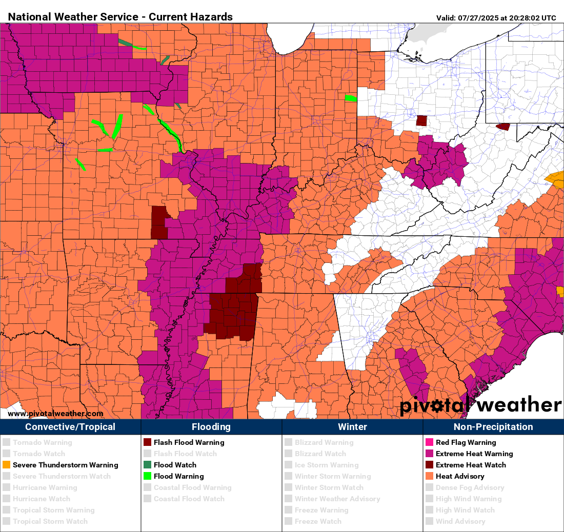
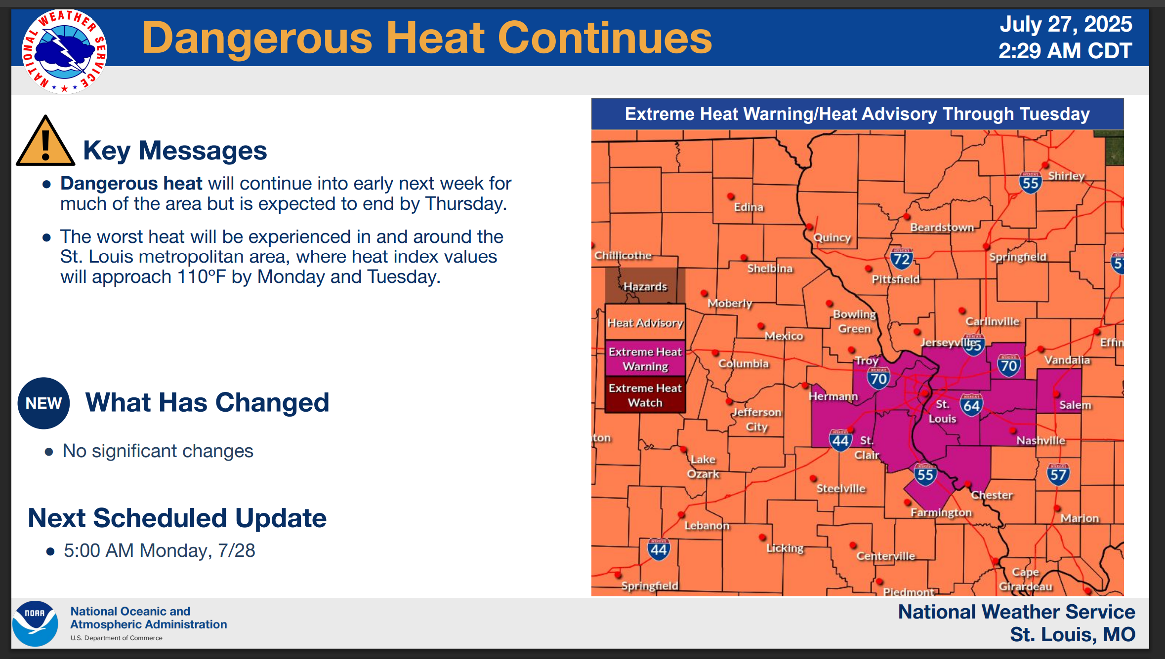
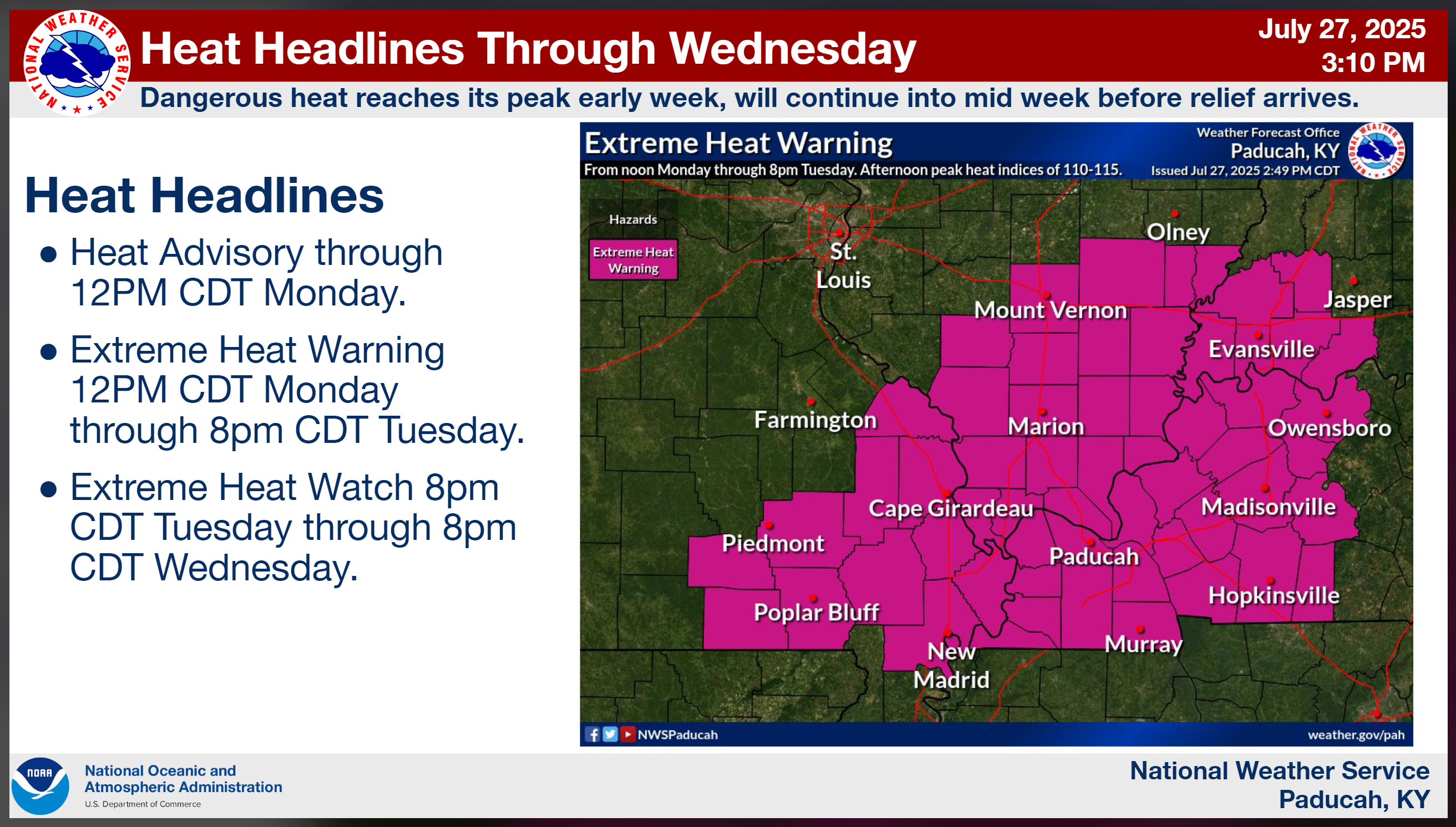
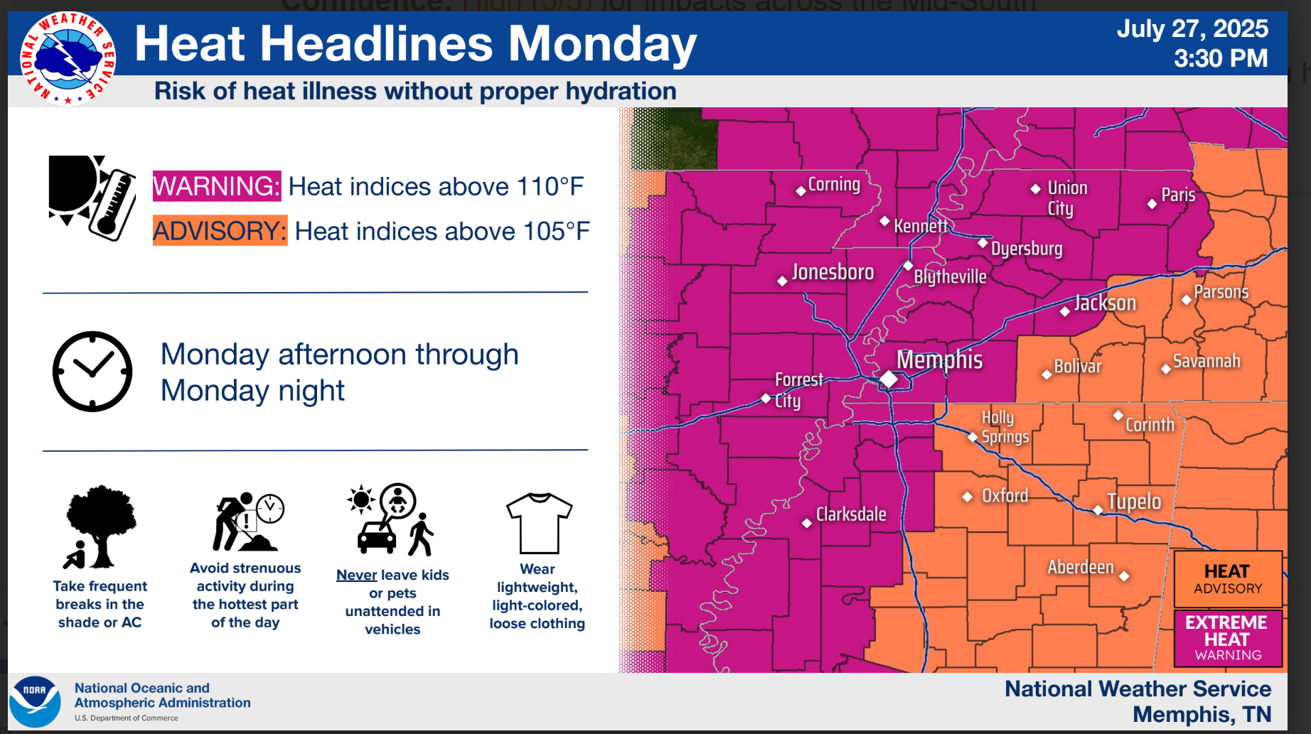
Warnings and advisories.
Double-click on this image to enlarge.
Randolph and Ste. Geneviève Counties are also included in the extreme heat warning.
.
.
A quick forecast glance. Your 48-hour forecast Graphics


.

.

.

Forecast discussion.
- Extreme heat index values are possible today through Wednesday.
- Areas with clouds and precipitation will be cooler. Keep that in mind.
- The hottest air temperatures of the year are likely to occur today through Wednesday.
- Scattered thunderstorms will be possible through Thursday.
- July thunderstorms can produce strong and gusty winds. Frequent cloud-to-ground lightning, as well.
- A strong cold front is expected to push through the region on Wednesday and Thursday. This will bring somewhat cooler air and much less humid air to the area by Thursday and Friday.
- Questions remain on how long the somewhat cooler air will linger.
.

.
Good morning, everyone.
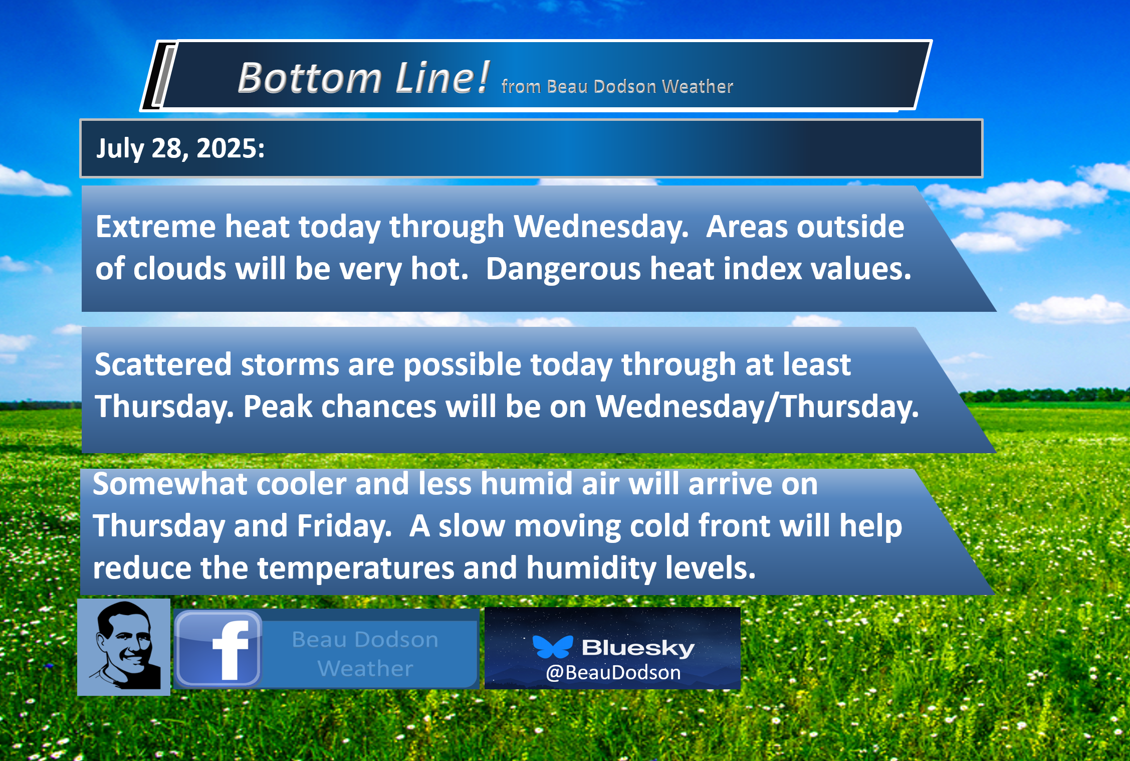
An extreme heat event is expected to persist today through Wednesday.
There are some questions about cloud cover today and scattered thunderstorms. Where the clouds are thicker, heat index values will be lower. This will be the saving grace for some areas.
Areas outside of clouds and rain will experience highs in the mid-to-upper 90s. Heat index values of 108 to 116 degrees are likely. These would be the hottest readings of 2025, thus far.
Use care if you must work outside. Coaches and band directors should consider the weather forecast when scheduling practice.
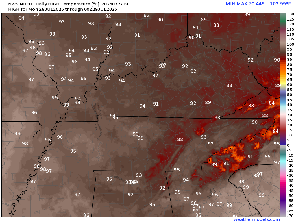
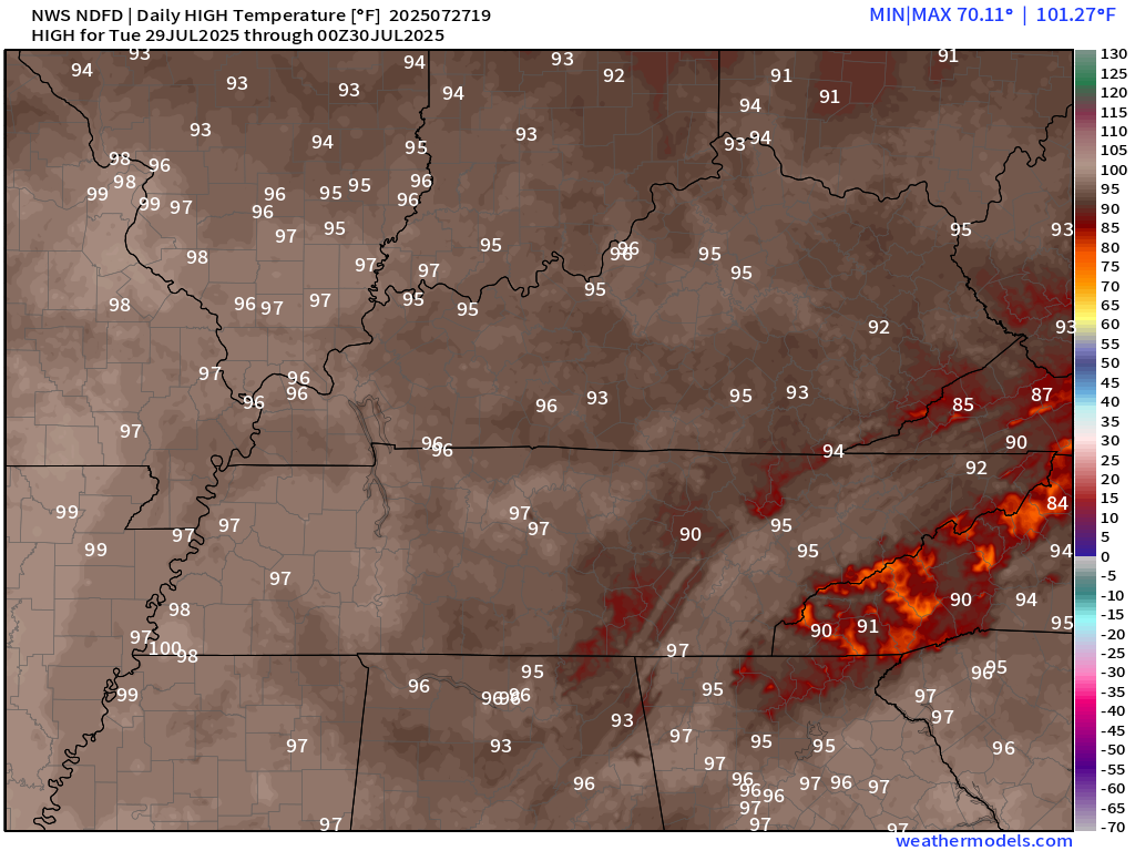
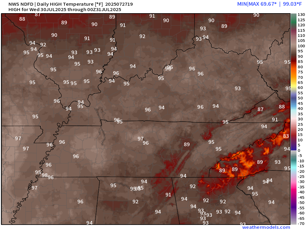
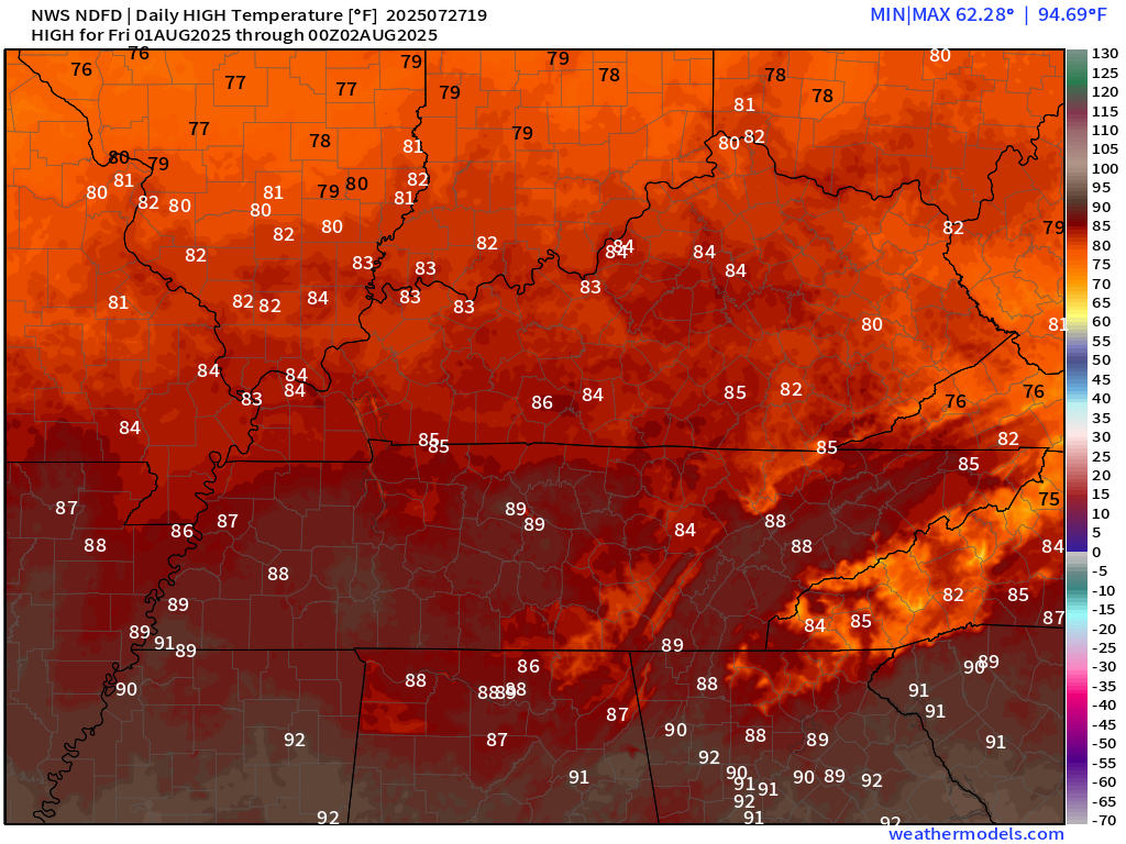
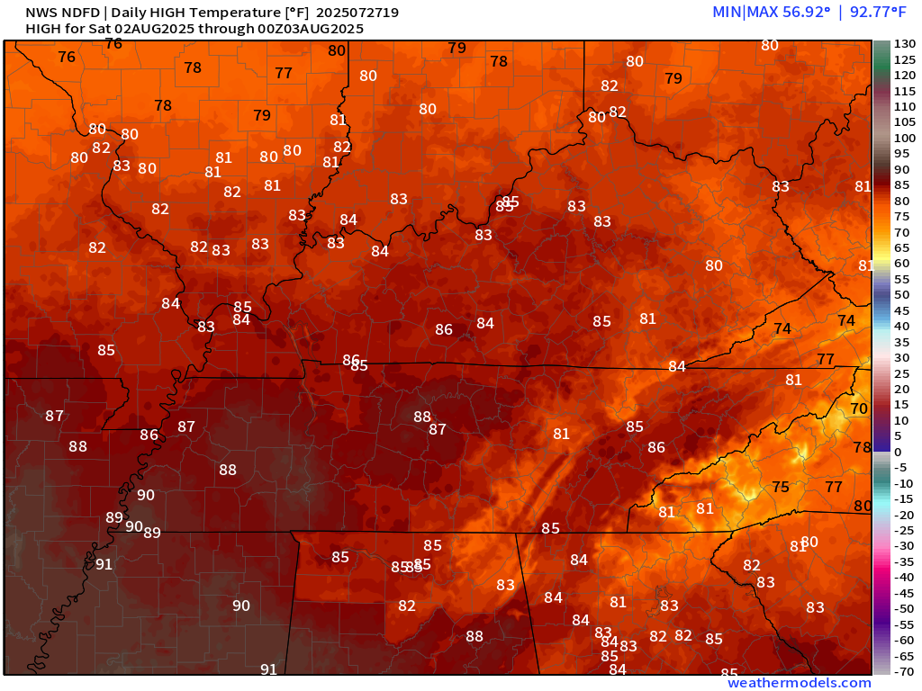
Here are the daily temperature forecasts. Tuesday should be hotter than today.
Keep in mind, heat index values (what your body responds to) will be much higher than this today through at least Wednesday (for some on Thursday, as well).
Today
Tomorrow
Wednesday
Thursday
Friday
Saturday
.
The peak of the heat wave will likely be on Tuesday
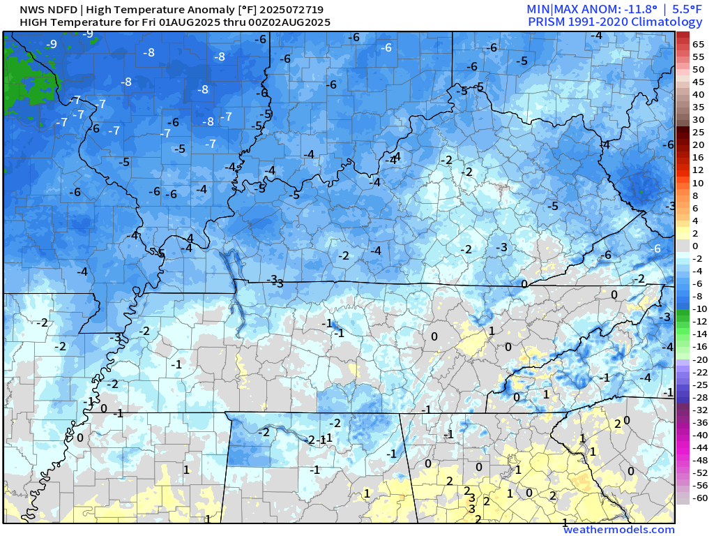
Here are the temperature anomalies. How many degrees above or below average will temperatures be?
Normal highs are around 90 degrees. Normal lows are around 68 degrees.
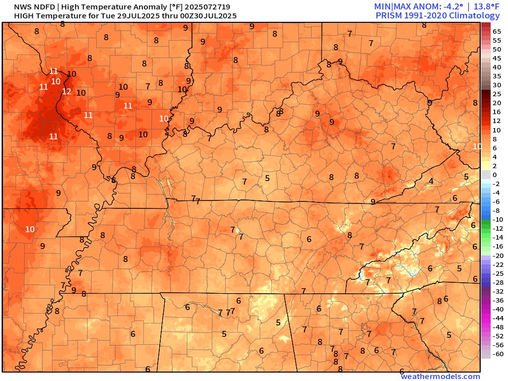
Now, compare that to Friday’s temperature anomaly map. Much cooler by Friday.
.
Somewhat cooler air and much less humid air will arrive on Thursday and Friday. The front will slowly move north to south. Some areas will remain hot on Thursday. Keep that in mind, as well.
The front will deliver highs in the eighties and heat index values below 90 degrees on Thursday (north) and across the area on Friday, Saturday, and Sunday.
There remain questions about how long the somewhat cooler and less humid air will linger in the region. Some of the data shows three or four days, and other data shows more than four days.
Let’s root for the longer-than-four-day solutions. I know everyone is tired of the heat and muggy air.
Summer is not over. The heat will return. The muggy air will return. We still have to get through August and part of September.
Our average temperatures really start to drop as we move into September.
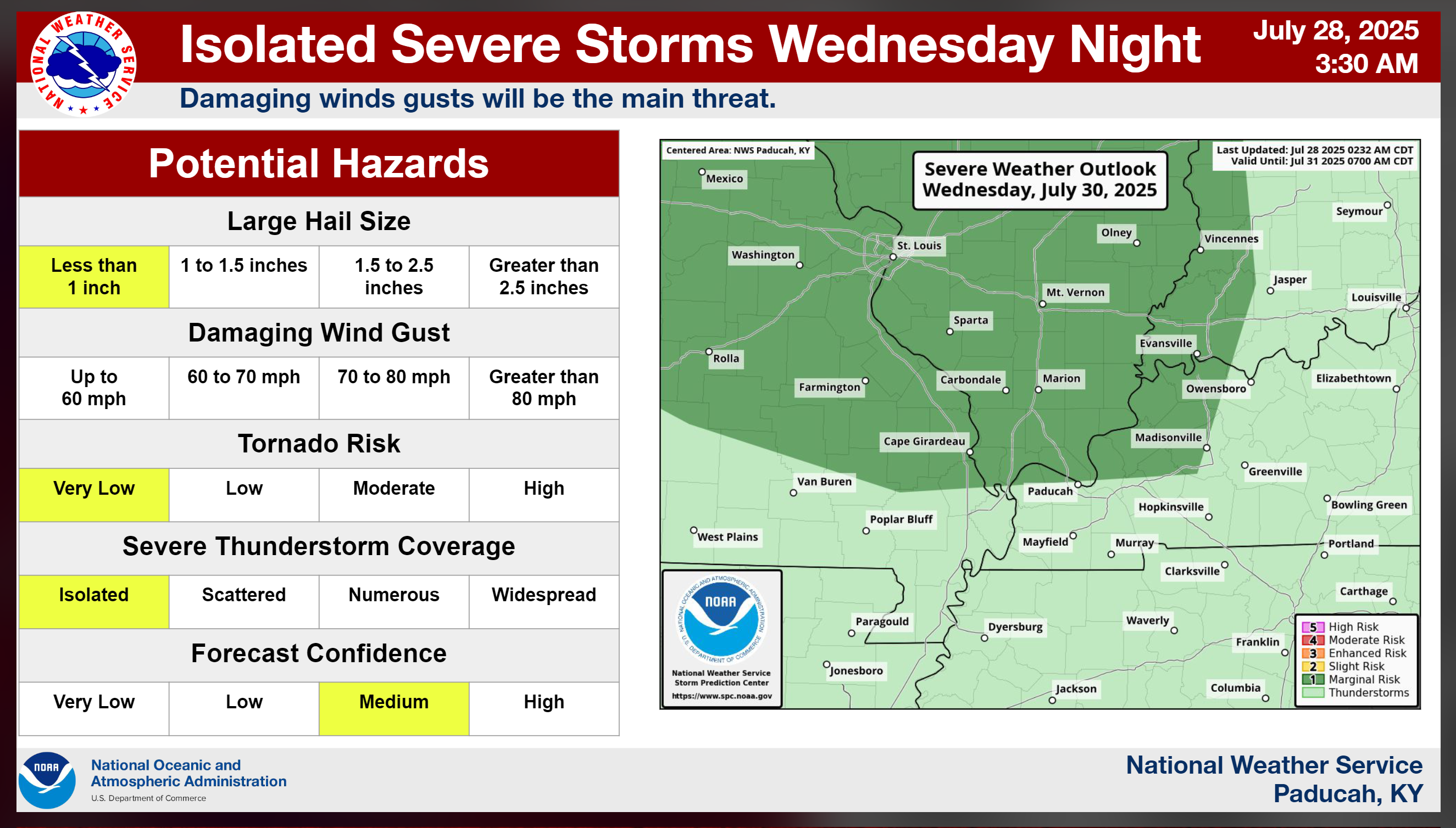
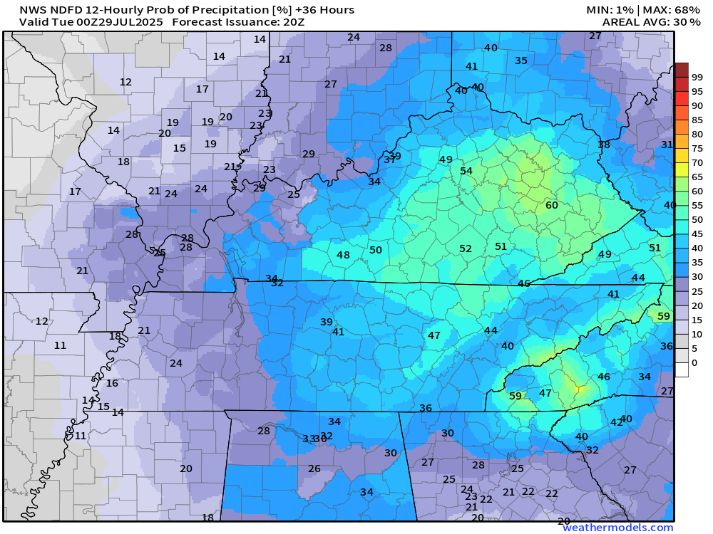
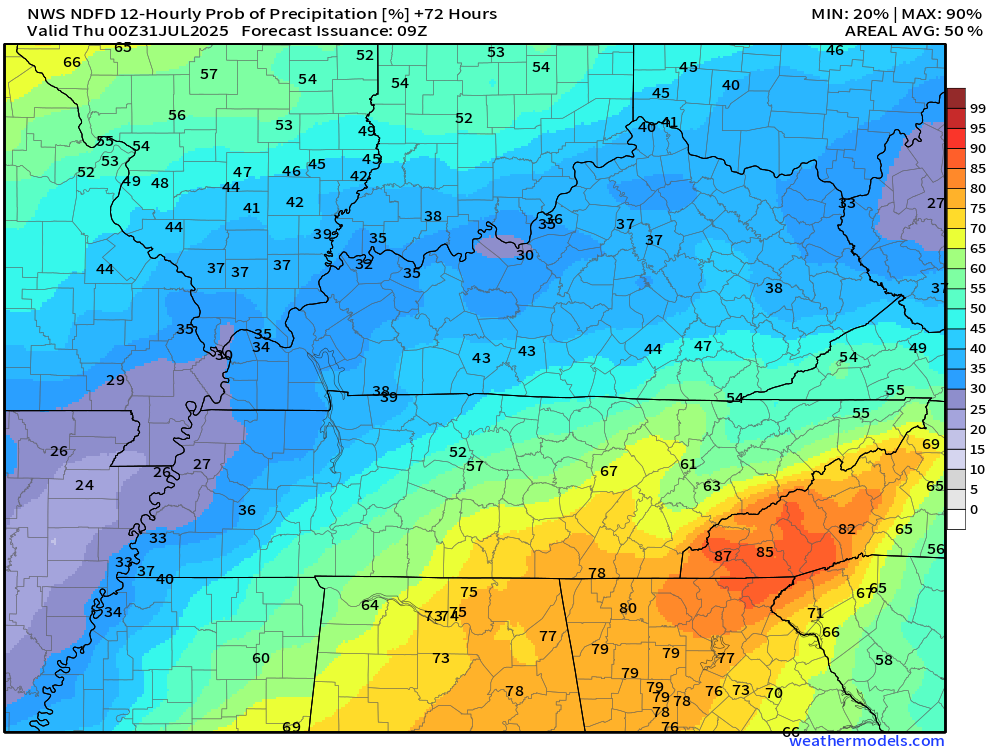
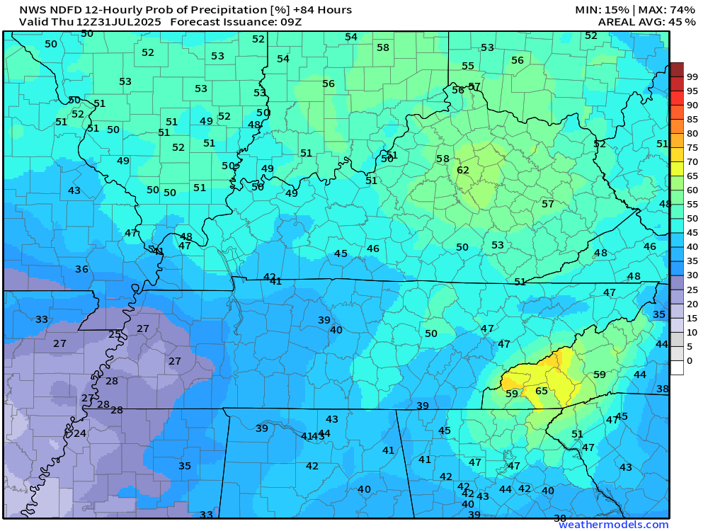
Scattered thunderstorms will be possible today through Thursday. Peak chances will be along a cold front on Wednesday and Thursday.
Some of the thunderstorms will produce locally heavy rain, frequent lightning, and gusty winds.
The Storm Prediction Center has us in a marginal (level 1 risk) on Wednesday.
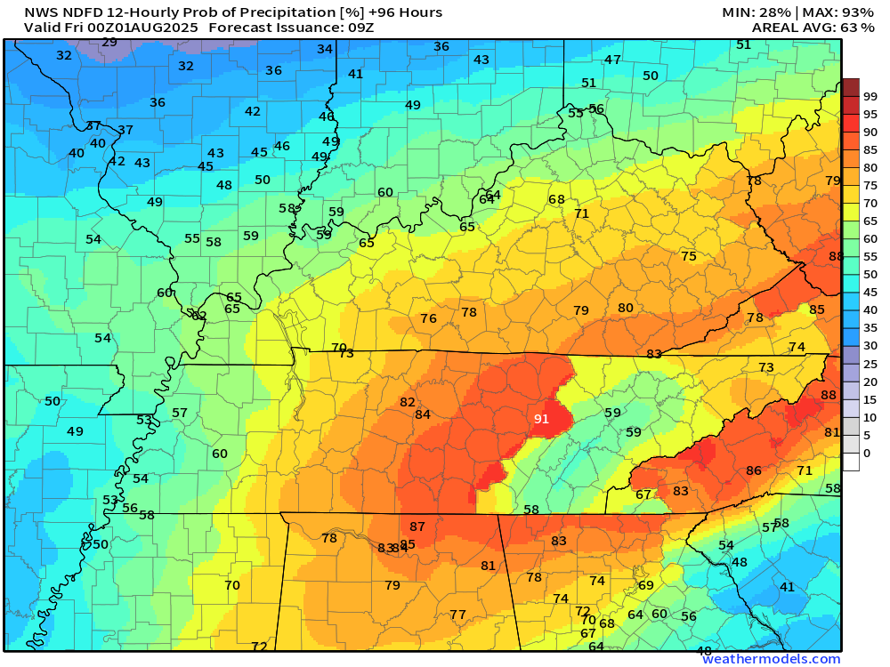
Let’s look at the rain probabilities.
Monday 7 am to 7 pm
.
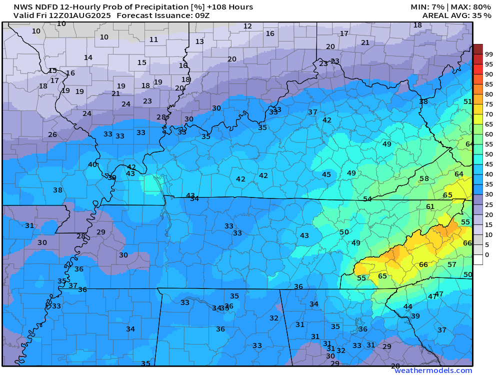
Wednesday 7 am to 7 pm
.
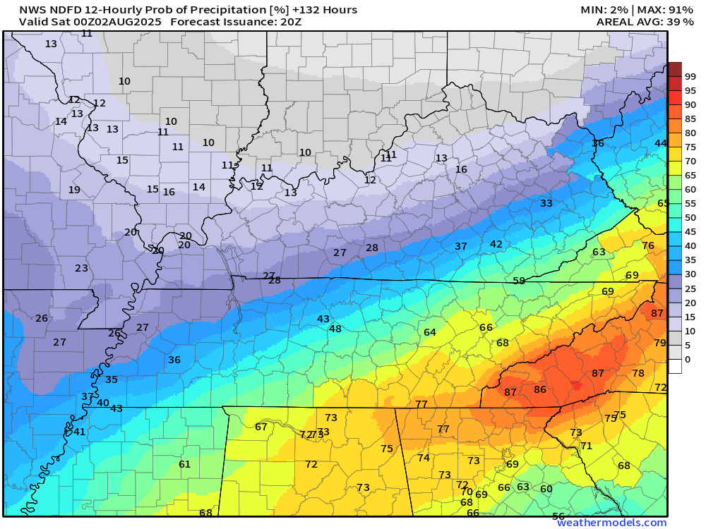
Wednesday 7 pm to Thursday 7 am
.
Thursday 7 am to 7 pm
.
Thursday 7 pm to Friday 7 am
.
Friday 7 am to Friday 7 pm
.
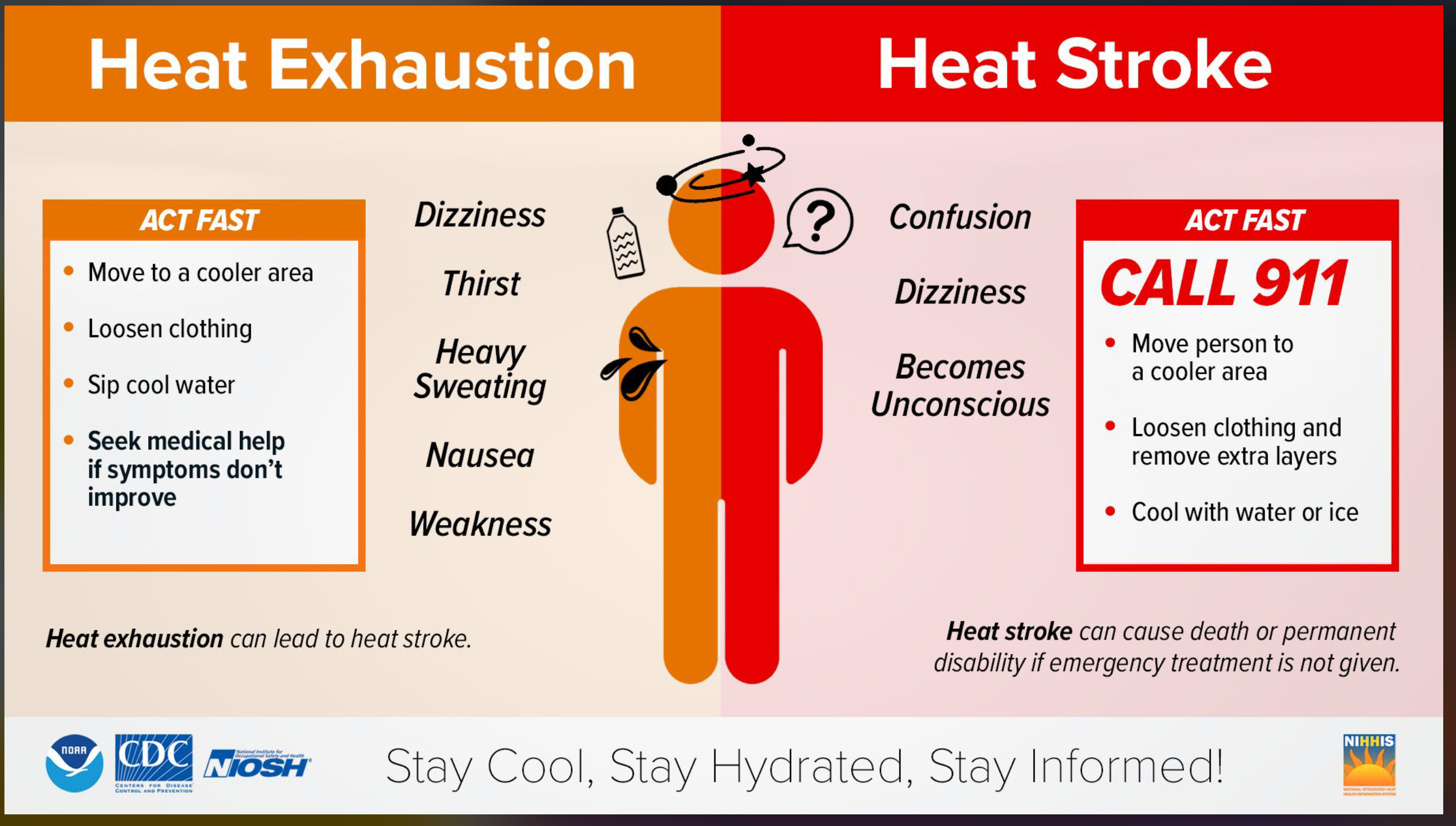
Use care in the heat. Remember the signs of heat illness.
.
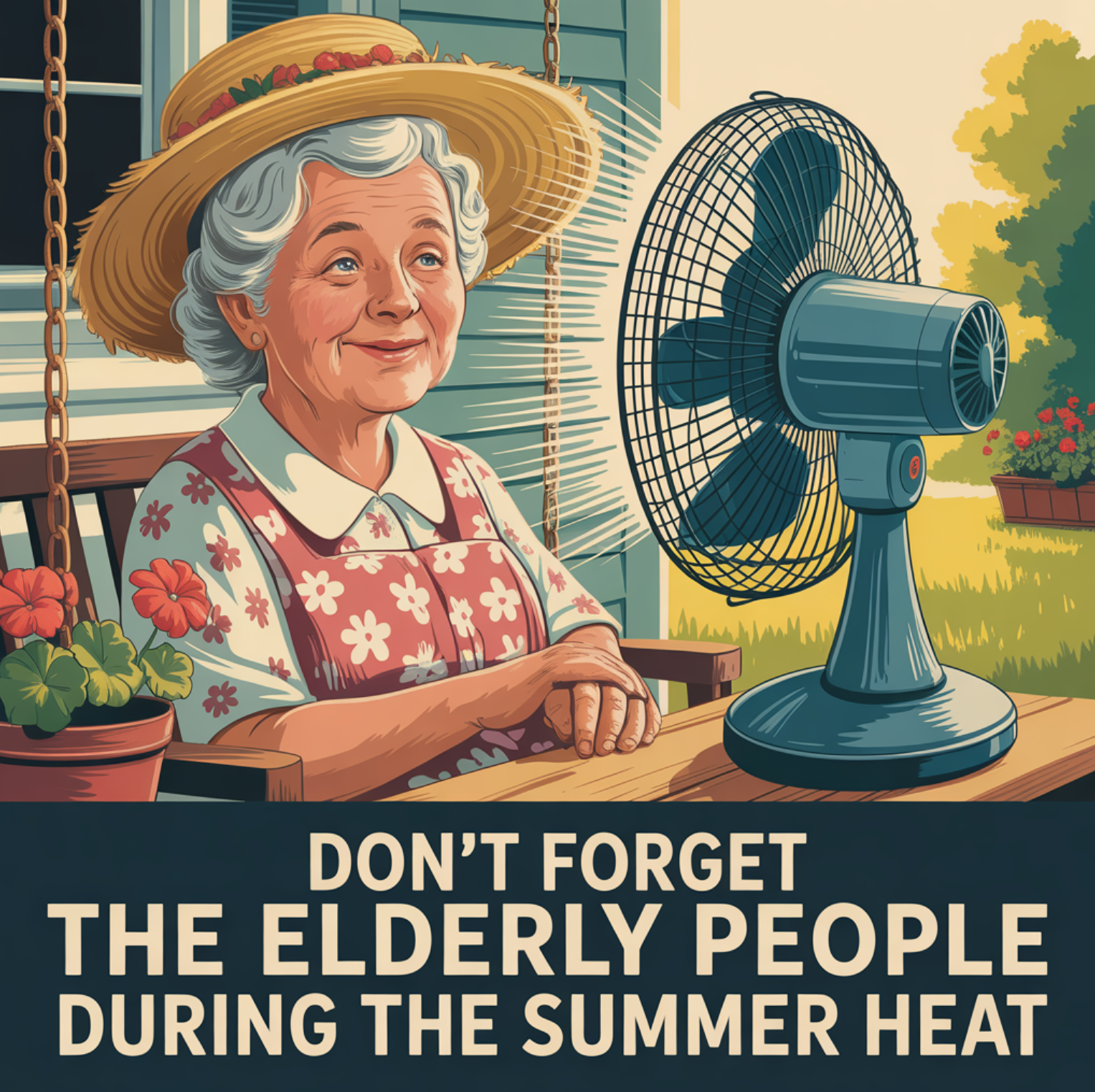
Don’t forget to check on the elderly during this extended period of heat.
.
Change your pets’ water bowls frequently, as well.

.

.
The timestamp (upper left) is in Zulu. 12z=7 am. 18z=1 pm. 00z=7 pm.
Double-click the animation to enlarge it.
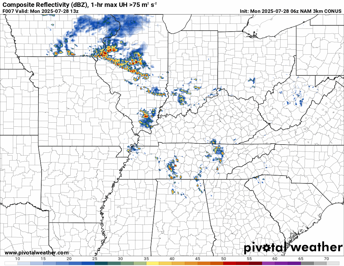
Hrrr model

.
The timestamp (upper left) is in Zulu. 12z=7 am. 18z=1 pm. 00z=7 pm.
Double-click the animation to enlarge it.
NAM 3K model
..
.
Click here if you would like to return to the top of the page.
.Average high temperatures for this time of the year are around 89 degrees.
Average low temperatures for this time of the year are around 69 degrees.
Average precipitation during this time period ranges from 1.00″ to 1.25″
Six to Ten Day Outlook.
Blue is below average. Red is above average. The no color zone represents equal chances.
Average highs for this time of the year are in the lower 60s. Average lows for this time of the year are in the lower 40s.

Green is above average precipitation. Yellow and brown favors below average precipitation. Average precipitation for this time of the year is around one inch per week.

.

Average low temperatures for this time of the year are around 69 degrees.
Average precipitation during this time period ranges from 1.00″ to 1.25″
.
Eight to Fourteen Day Outlook.
Blue is below average. Red is above average. The no color zone represents equal chances.

Green is above average precipitation. Yellow and brown favors below average precipitation. Average precipitation for this time of the year is around one inch per week.

.
.
.
We have a new service to complement your www.weathertalk.com subscription. This does NOTreplace www.weathertalk.com It is simply another tool for you to receive severe weather information.
.
https://weathercallservices.com/beau-dodson-weather


Want to receive the daily forecast/other products on your Beau Dodson Weather app?
Did you know you have four options in your www.weathertalk.com account
You will then receive these via your Beau Dodson Weather app.
Just log into your www.weathertalk.com account
Click the NOTIFICATION SETTINGS TAB
Then, turn them on (green) and off (red)
🌪️ Number 1 is the most important one. Severe alerts, tornado alerts, and so on.
Number 2 is the daily video, blog, livestream alerts, and severe weather Facebook threads on severe days or winter storm days.
Number 3 is the daily forecast. I send that out every day during the afternoon hours. It is the seven-day forecast, hazardous weather outlook, fire outlook, and more.
Number 4 is to receive the daily video, blog, and other content on NON-severe weather days (every day without severe threats in other words)
GREEN IS ON
RED IS OFF

I am going to start going live during bigger severe weather events.
Check it out here https://www.youtube.com/user/beaudodson
Click the subscribe button (it’s a free subscription button), and it will alert you when I go live. I will also send out alerts to the app when I go live for an event.

.

Radars and Lightning Data
Interactive-city-view radars. Clickable watches and warnings.
https://wtalk.co/B3XHASFZ
Old legacy radar site (some of you like it better)
https://weatherobservatory.com/weather-radar.htm
If the radar is not updating then try another one. If a radar does not appear to be refreshing then hit Ctrl F5. You may also try restarting your browser.
Backup radar site in case the above one is not working.
https://weathertalk.com/morani
Regional Radar
https://imagery.weathertalk.com/prx/RadarLoop.mp4
** NEW ** Zoom radar with chaser tracking abilities!
ZoomRadar
If the radar is not working, then email me: Email me at beaudodson@usawx.com
.
We do have some sponsors! Check them out.
Roof damage from recent storms? Link – Click here
INTEGRITY ROOFING AND EXTERIORS!
⛈️ Roof or gutter damage from recent storms? Today’s weather is sponsored by Integrity Roofing. Check out their website at this link https://www.ourintegritymatters.com/

![]()
![]()
![]()
Make sure you have three to five ways of receiving your severe weather information.
Weather Talk is one of those ways! Now, I have another product for you and your family.

.
Want to add more products to your Beau Dodson Weather App?
Receive daily videos, weather blog updates on normal weather days and severe weather and winter storm days, your county by county weather forecast, and more!
Here is how to do add those additional products to your app notification settings!
Here is a video on how to update your Beau Dodson Weather payment.
The app is for subscribers. Subscribe at www.weathertalk.com/welcome then go to your app store and search for WeatherTalk
Subscribers, PLEASE USE THE APP. ATT and Verizon are not reliable during severe weather. They are delaying text messages.
The app is under WeatherTalk in the app store.

Apple users click here

Android users click here
.
Radars and Lightning Data
Interactive-city-view radars. Clickable watches and warnings.
https://wtalk.co/B3XHASFZ
Old legacy radar site (some of you like it better)
https://weatherobservatory.com/weather-radar.htm
If the radar is not updating then try another one. If a radar does not appear to be refreshing then hit Ctrl F5. You may also try restarting your browser.
Backup radar site in case the above one is not working.
https://weathertalk.com/morani
Regional Radar
https://imagery.weathertalk.com/prx/RadarLoop.mp4
** NEW ** Zoom radar with chaser tracking abilities!
ZoomRadar
Lightning Data (zoom in and out of your local area)
https://wtalk.co/WJ3SN5UZ
Not working? Email me at beaudodson@usawx.com
National map of weather watches and warnings. Click here.
Storm Prediction Center. Click here.
Weather Prediction Center. Click here.
.

Live lightning data: Click here.
Real time lightning data (another one) https://map.blitzortung.org/#5.02/37.95/-86.99
Our new Zoom radar with storm chases
.
.

Interactive GOES R satellite. Track clouds. Click here.
GOES 16 slider tool. Click here.
College of DuPage satellites. Click here
.

Here are the latest local river stage forecast numbers Click Here.
Here are the latest lake stage forecast numbers for Kentucky Lake and Lake Barkley Click Here.
.
.
Find Beau on Facebook! Click the banner.


 .
.