

.
I have some question-and-answer threads over on the Facebook page. Link to those threads CLICK HERE
Or email me at beaudodsonweather@gmail.com
I am going to start going live during events.
I have a live stream running now (I am learning how to use the software).
Check it out here https://www.youtube.com/user/beaudodson
Click the subscribe button (it is a free subscribe button), and it will alert you when I go live. I will also send out alerts to the app when I go live for an event.

.

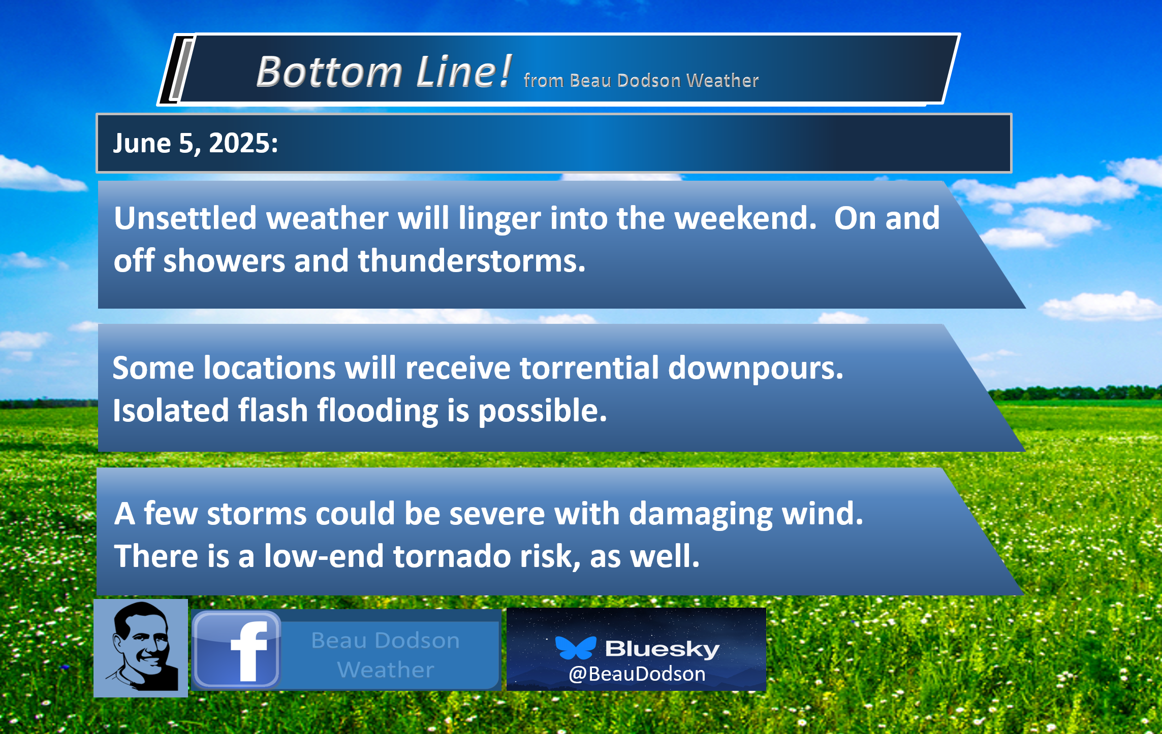
🌪️ Seven-Day Tornado Outlook ⛈️
June 5th through June 12th
Current risk: LOW RISK.
Current confidence level: High confidence in the forecast.
Comment: There is a low risk of tornadoes on Friday and Saturday. The greater concern will be a few reports of damaging wind gusts.
.

Seven-Day Hazardous Weather Outlook
1. Is lightning in the forecast? YES. Lightning is possible today through Saturday. Lightning is possible on Monday and Monday night. I will monitor late next week.
2. Are severe thunderstorms in the forecast? YES. There is a small risk of downburst winds today.
There is a risk of severe thunderstorms on Friday and Saturday. The primary concern will be damaging winds. There is a low risk of an isolated tornado.
3. Is flash flooding in the forecast? ISOLATED ISSUES. Locally heavy thunderstorms are expected today into the weekend. Several rounds of showers and thunderstorms. This could result in brief flooding issues. Ditches overflowing, commonly flooded roadways, and so on.
I increased the rain chances for Saturday. It now appears the front will stall.
4. Will non-thunderstorm winds top 40 mph? NO.
5. Will temperatures rise above 90 degrees? NO.
6. Will the heat index rise above 100 degrees? NO.
.
A quick forecast glance. Your 48-hour forecast Graphics


.

.


Forecast discussion.
- Scattered showers and thunderstorms today through Saturday.
- Locally, extremely heavy rainfall totals.
- A few storms could also be severe over the coming days.
- Saturday is trending wetter.
- Another chance of showers and thunderstorms on Monday/Monday night.
- Watching late next week for more thunderstorms.
.

Good morning,
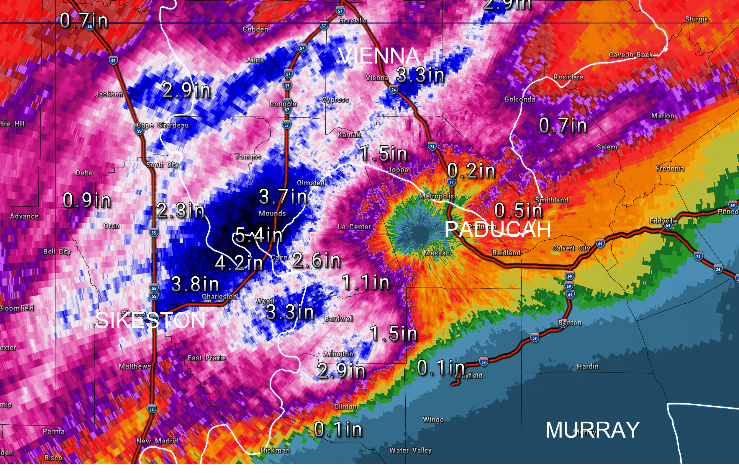
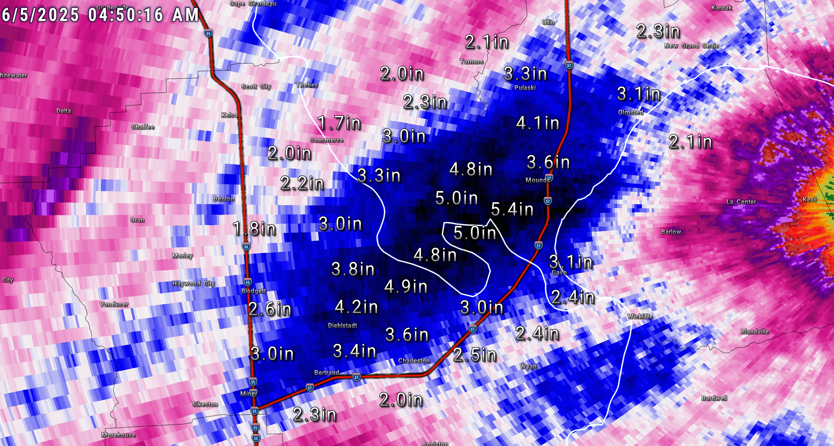
There were some areas with extremely high rainfall totals overnight. This was not a surprise. We expected some big totals from slow-moving thunderstorms.
Check out some of these overnight rainfall numbers.
The heaviest totals fell in Alexander, Pulaski, Scott, and Mississippi Counties.
Over five inches in some locations. This is typical for slow-moving summer thunderstorms. The atmosphere is juiced. Storms tap into the high moisture levels and can drop torrential rain.
.
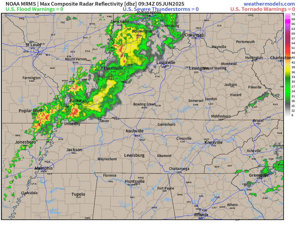
This is what radar looked like at 6 AM. Showers and thunderstorms are moving west to east across the region. Some of the storms were producing torrential downpours.
Avoid flooded roadways.
.
The active weather pattern will continue into today. It also now appears rain chances will linger into Saturday.
We had hoped the front would push south on Saturday, but the latest data keeps it farther north. That means more showers and thunderstorms.
A few storms could produce strong wind gusts today. The overall severe weather risk is low, but not zero.
The primary concern will be downburst winds from collapsing thunderstorms.
A greater risk of severe weather is expected to develop on Friday and Saturday. See below.
The primary concern will be damaging wind gusts. An isolated tornado can’t be ruled out. Monitor your app alerts.
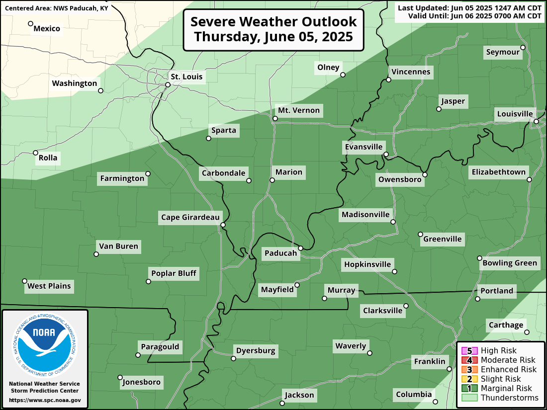
Here is today’s severe weather outlook. The dark green is where the Storm Prediction Center has placed a low-level one risk (marginal). That is the lowest risk they have.
The light green is where storms are possible, but they are expected to remain below severe levels.
.
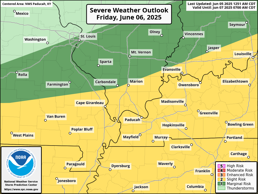
Here is the updated Friday SPC severe weather outlook. A level one and two risk blankets our region. The level one risk is in dark green. The level two risk is in yellow.
There could be adjustments to this graphic. Monitor updates.
It appears peak thunderstorm chances will arrive during the mid-morning hours into the afternoon.
.
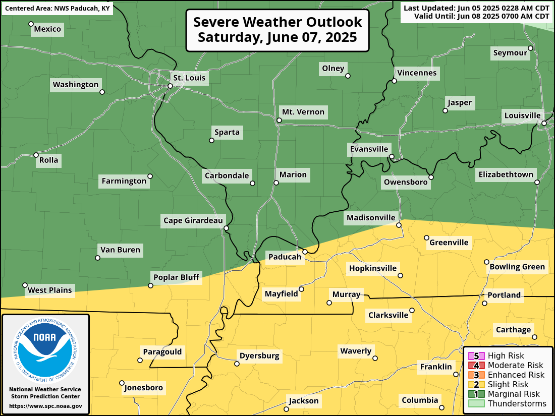
Finally, here is Saturday’s SPC severe weather outlook. A level one and two risk.
There could be adjustments to this graphic. It is still three days out. Monitor updates.
.
Again, rainfall totals will vary wildly. Typical for June.
There will be showers and thunderstorms on the radar from today through Saturday. It won’t rain all the time at any given location. However, precipitation is expected to be visible on the weather radars through the period.
During the summer months, one county could have two to three inches of rain. A neighboring county could remain mostly dry. If you have lived in this area for any length of time, then you will know this.
If thunderstorms train over the same area, then this will enhance rainfall totals.
Generally, additional rainfall totals today through Saturday will range from 1.00″ to 2.00″. Then, there will be pockets of much higher totals.
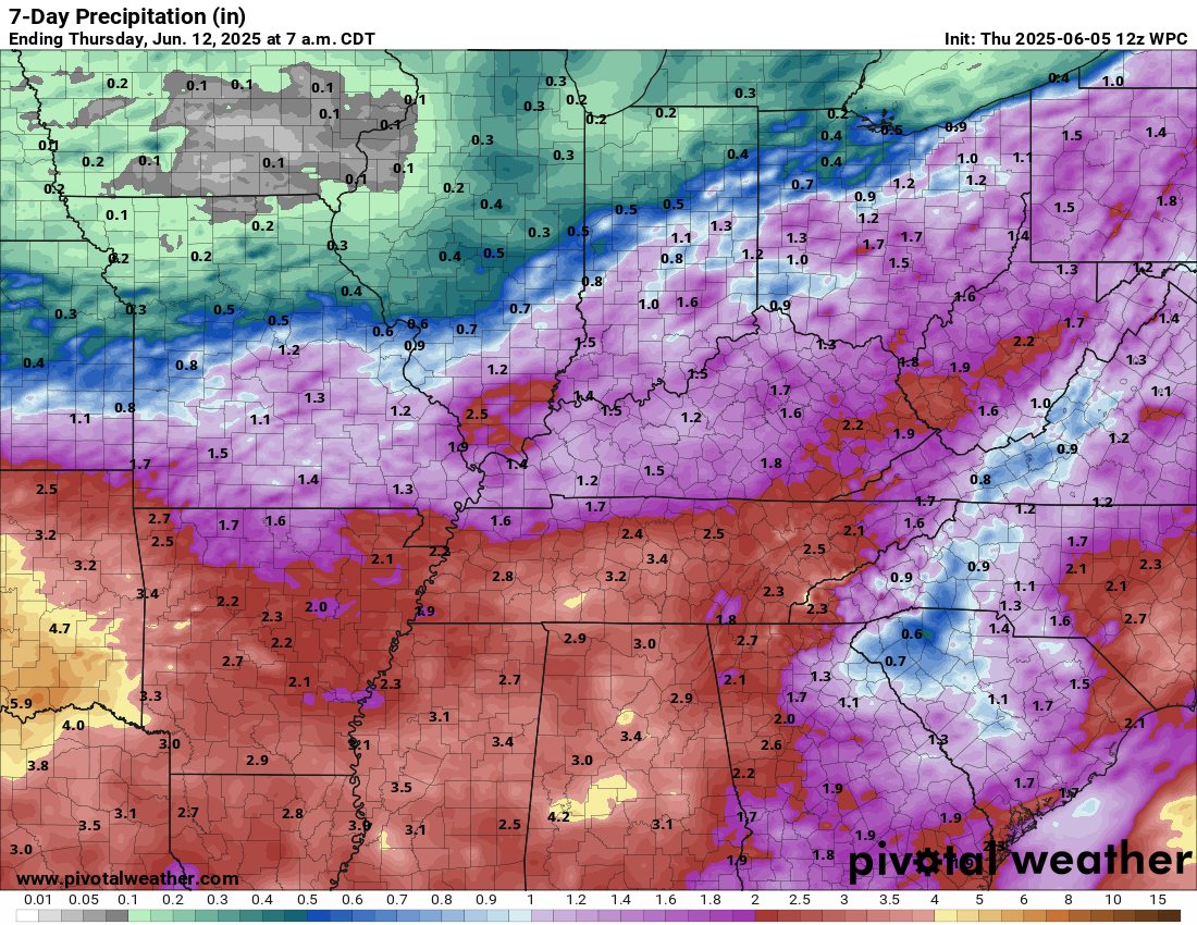
Here is the official WPC/NOAA rainfall outlook.
Double click to enlarge this graphic. This hasn’t changed much over the last few days. Some locations have already received these amounts.
.
As mentioned above, rain chances will continue into Saturday. The front is going to be farther north. We can’t seem to catch a break with these weekend rain events.
Have a plan B, just in case of rain this weekend. Then, you will be prepared.
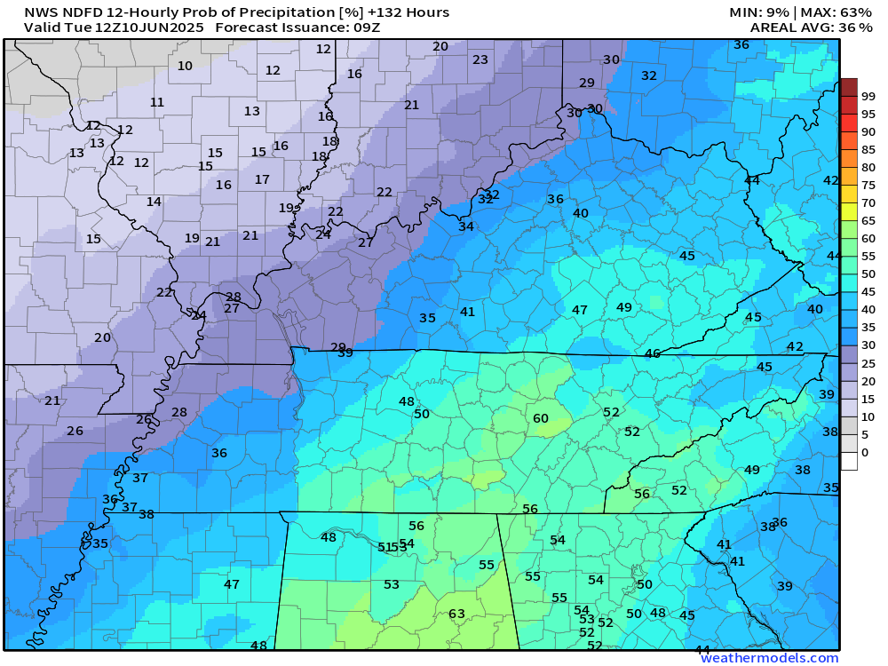
Let’s look at the latest rain probability graphics. This will give you a decent idea of what we are looking at for each twelve-hour period (7 AM to 7 PM and 7 PM to 7 AM).
These graphics display the rain probability (% chances)
Thursday
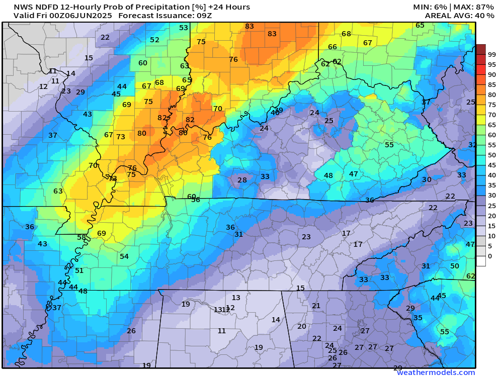
Thursday night
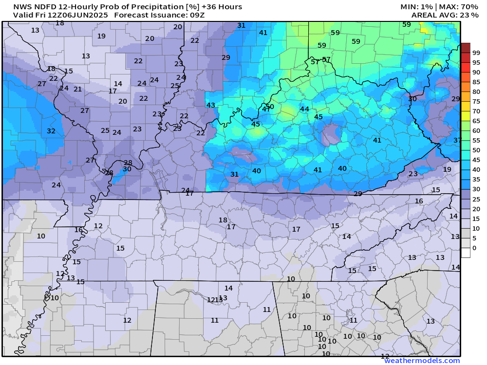
Friday
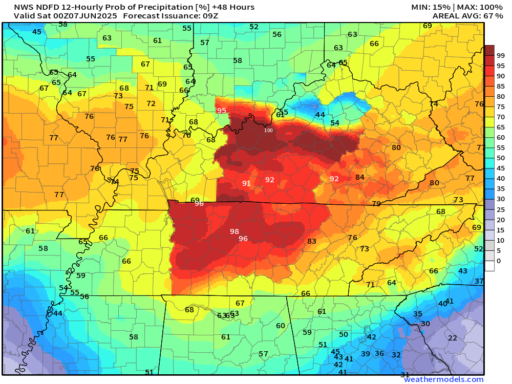
Friday night
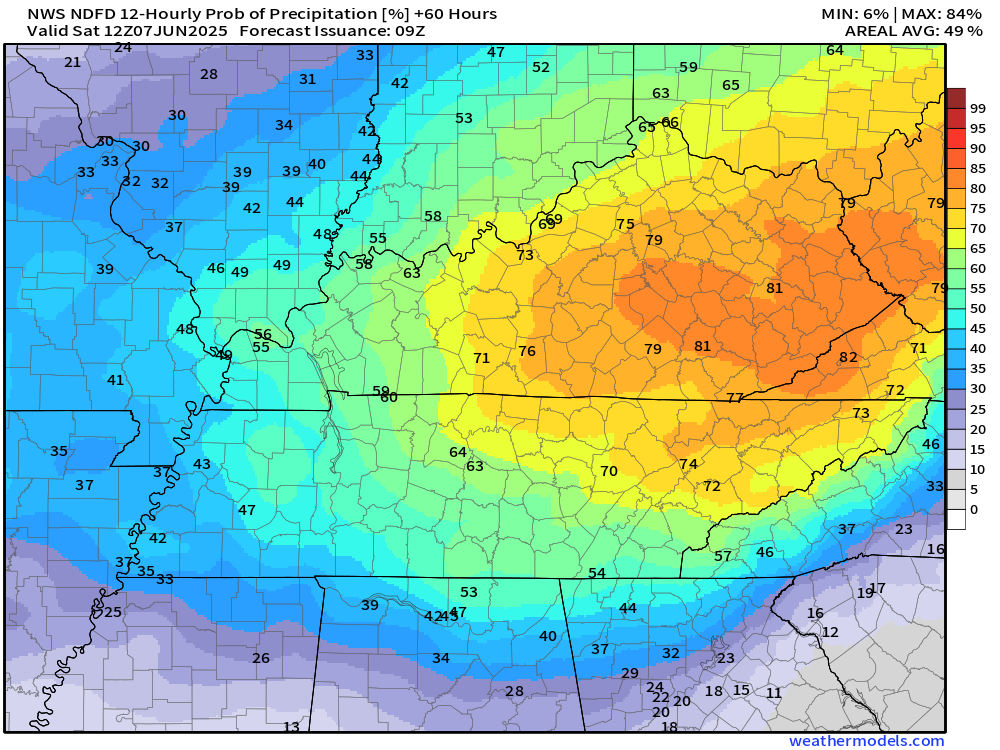
Saturday
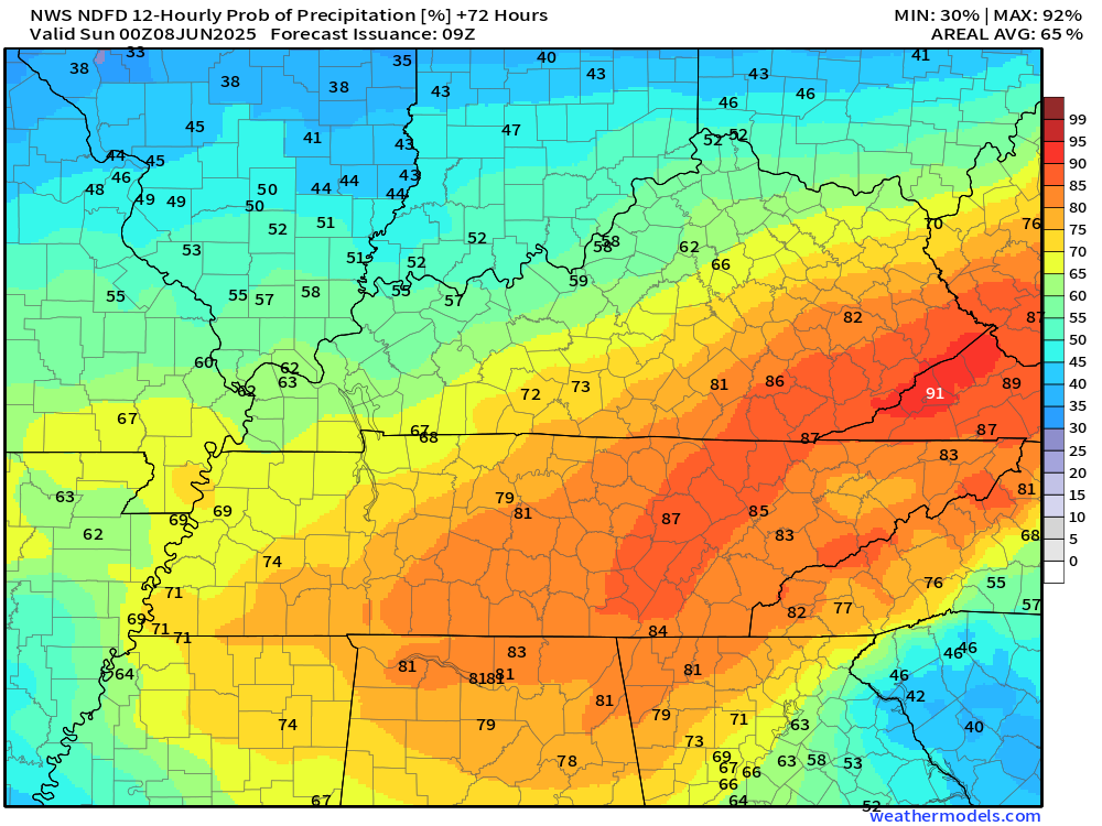
Saturday night
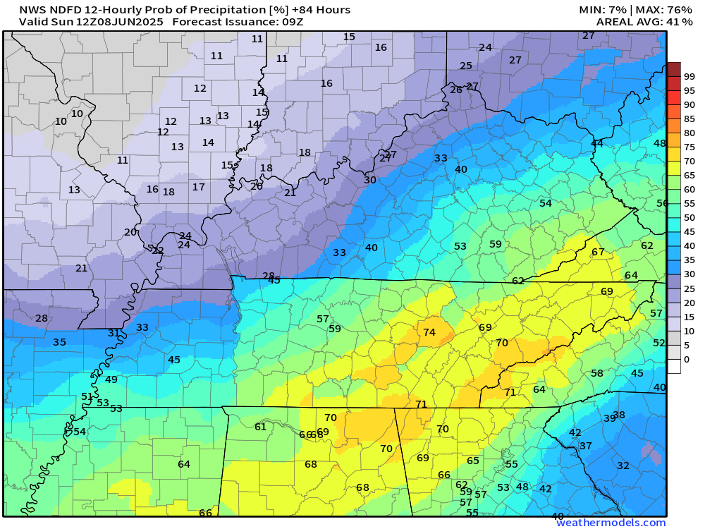
Sunday
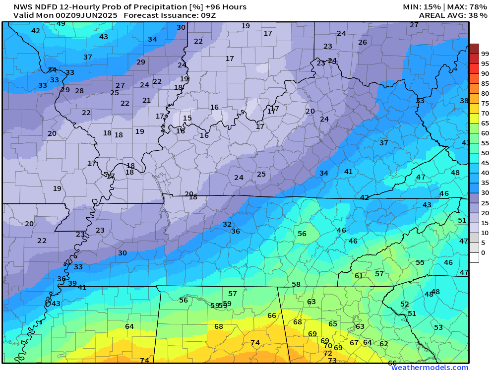
Sunday night
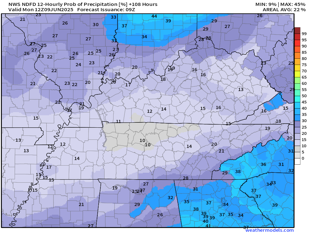
Monday
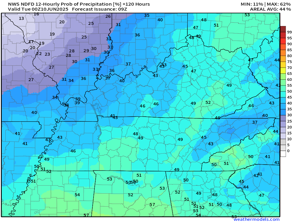
Monday night
.
A front will push through the region on Monday/Monday night. This will bring another round of showers and thunderstorms.
Tuesday and Wednesday should be dry.
I am watching next Friday through Monday for additional thunderstorm complexes. MCS’s.
We are moving towards MCS season.
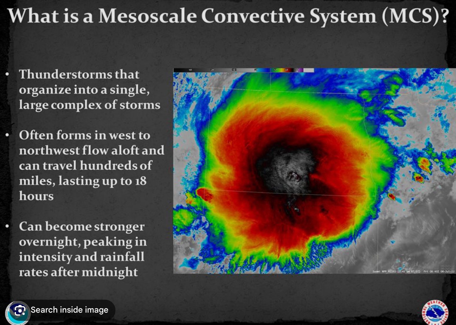
MCS’s are large summer thunderstorm complexes. They bring most of our summer rainfall.
When we enter a northwest jetstream flow, MCS chances increase. That is what I will be monitoring over the coming weeks.
Where does the northwest wind flow pattern develop? That is the question.
MCS’s can bring heavy rain and damaging wind gusts. They are common from June through late July.
It does not take much upper air energy to produce showers and thunderstorms during the month of June. Thus, I will need to closely monitor next week’s forecast. The week after, as well.
.

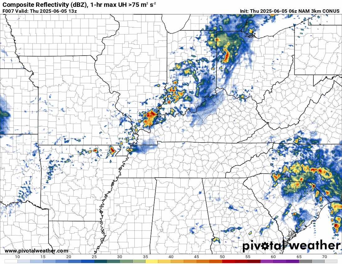
The timestamp (upper left) is in Zulu. 12z=7 am. 18z=1 pm. 00z=7 pm.
Double-click the animation to enlarge it.
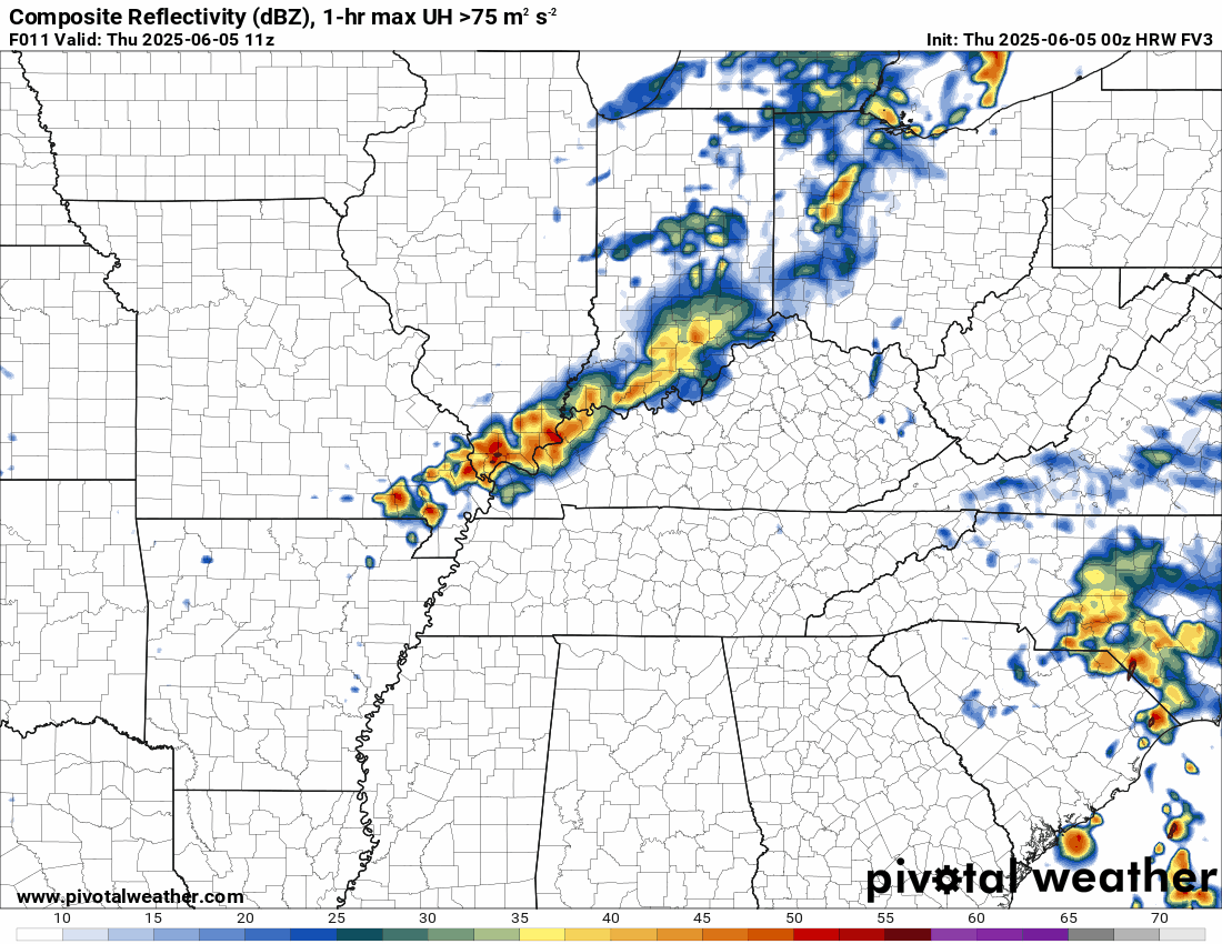
NAM 3K model.
.
Hrrr model. The timestamp (upper left) is in Zulu. 12z=7 am. 18z=1 pm. 00z=7 pm.
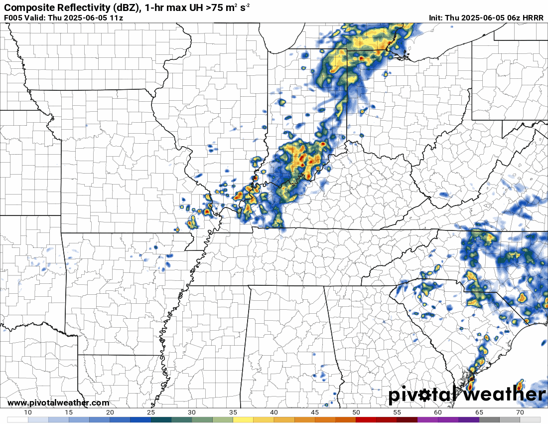
..
.
Click here if you would like to return to the top of the page.
.Average high temperatures for this time of the year are around 83 degrees.
Average low temperatures for this time of the year are around 62 degrees.
Average precipitation during this time period ranges from 1.00″ to 1.40″
Six to Ten Day Outlook.
Blue is below average. Red is above average. The no color zone represents equal chances.
Average highs for this time of the year are in the lower 60s. Average lows for this time of the year are in the lower 40s.

Green is above average precipitation. Yellow and brown favors below average precipitation. Average precipitation for this time of the year is around one inch per week.

.

Average low temperatures for this time of the year are around 63 degrees.
Average precipitation during this time period ranges from 1.20″ to 1.50″
.
Eight to Fourteen Day Outlook.
Blue is below average. Red is above average. The no color zone represents equal chances.

Green is above average precipitation. Yellow and brown favors below average precipitation. Average precipitation for this time of the year is around one inch per week.

.
.
.
We have a new service to complement your www.weathertalk.com subscription. This does NOTreplace www.weathertalk.com It is simply another tool for you to receive severe weather information.
.


.

Radars and Lightning Data
Interactive-city-view radars. Clickable watches and warnings.
https://wtalk.co/B3XHASFZ
Old legacy radar site (some of you like it better)
https://weatherobservatory.com/weather-radar.htm
If the radar is not updating then try another one. If a radar does not appear to be refreshing then hit Ctrl F5. You may also try restarting your browser.
Backup radar site in case the above one is not working.
https://weathertalk.com/morani
Regional Radar
https://imagery.weathertalk.com/prx/RadarLoop.mp4
** NEW ** Zoom radar with chaser tracking abilities!
ZoomRadar
If the radar is not working, then email me: Email me at beaudodson@usawx.com
.
We do have some sponsors! Check them out.
Roof damage from recent storms? Link – Click here
INTEGRITY ROOFING AND EXTERIORS!
⛈️ Roof or gutter damage from recent storms? Today’s weather is sponsored by Integrity Roofing. Check out their website at this link https://www.ourintegritymatters.com/

![]()
![]()
![]()
Make sure you have three to five ways of receiving your severe weather information.
Weather Talk is one of those ways! Now, I have another product for you and your family.

.
Want to add more products to your Beau Dodson Weather App?
Receive daily videos, weather blog updates on normal weather days and severe weather and winter storm days, your county by county weather forecast, and more!
Here is how to do add those additional products to your app notification settings!
Here is a video on how to update your Beau Dodson Weather payment.
The app is for subscribers. Subscribe at www.weathertalk.com/welcome then go to your app store and search for WeatherTalk
Subscribers, PLEASE USE THE APP. ATT and Verizon are not reliable during severe weather. They are delaying text messages.
The app is under WeatherTalk in the app store.

Apple users click here

Android users click here
.
Radars and Lightning Data
Interactive-city-view radars. Clickable watches and warnings.
https://wtalk.co/B3XHASFZ
Old legacy radar site (some of you like it better)
https://weatherobservatory.com/weather-radar.htm
If the radar is not updating then try another one. If a radar does not appear to be refreshing then hit Ctrl F5. You may also try restarting your browser.
Backup radar site in case the above one is not working.
https://weathertalk.com/morani
Regional Radar
https://imagery.weathertalk.com/prx/RadarLoop.mp4
** NEW ** Zoom radar with chaser tracking abilities!
ZoomRadar
Lightning Data (zoom in and out of your local area)
https://wtalk.co/WJ3SN5UZ
Not working? Email me at beaudodson@usawx.com
National map of weather watches and warnings. Click here.
Storm Prediction Center. Click here.
Weather Prediction Center. Click here.
.

Live lightning data: Click here.
Real time lightning data (another one) https://map.blitzortung.org/#5.02/37.95/-86.99
Our new Zoom radar with storm chases
.
.

Interactive GOES R satellite. Track clouds. Click here.
GOES 16 slider tool. Click here.
College of DuPage satellites. Click here
.

Here are the latest local river stage forecast numbers Click Here.
Here are the latest lake stage forecast numbers for Kentucky Lake and Lake Barkley Click Here.
.
.
Find Beau on Facebook! Click the banner.


 .
.