
If you have not signed up for this, then consider doing so.
Weather Call will call you when a warning is issued. This is useful when we have tornadoes at night!
🌪️ NEW SERVICE 🌪️
I have partnered with WeatherCall to bring you an added layer of protection.
.
.
We have a new service to complement your www.weathertalk.com subscription. This does NOT replace www.weathertalk.com. It is simply another tool that allows you to receive severe weather information.
.


.

Radars and Lightning Data
Interactive-city-view radars. Clickable watches and warnings.
https://wtalk.co/B3XHASFZ
Old legacy radar site (some of you like it better)
https://weatherobservatory.com/weather-radar.htm
If the radar is not updating then try another one. If a radar does not appear to be refreshing then hit Ctrl F5. You may also try restarting your browser.
Backup radar site in case the above one is not working.
https://weathertalk.com/morani
Regional Radar
https://imagery.weathertalk.com/prx/RadarLoop.mp4
Zoom National Radar
ZoomRadar
.

.
I have some question-and-answer threads over on the Facebook page. Link to those threads CLICK HERE
Or email me at beaudodsonweather@gmail.com
.

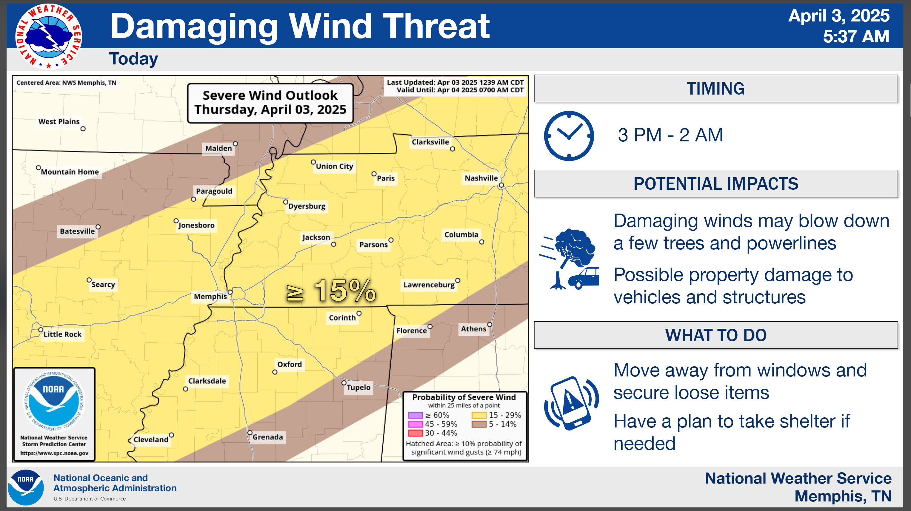
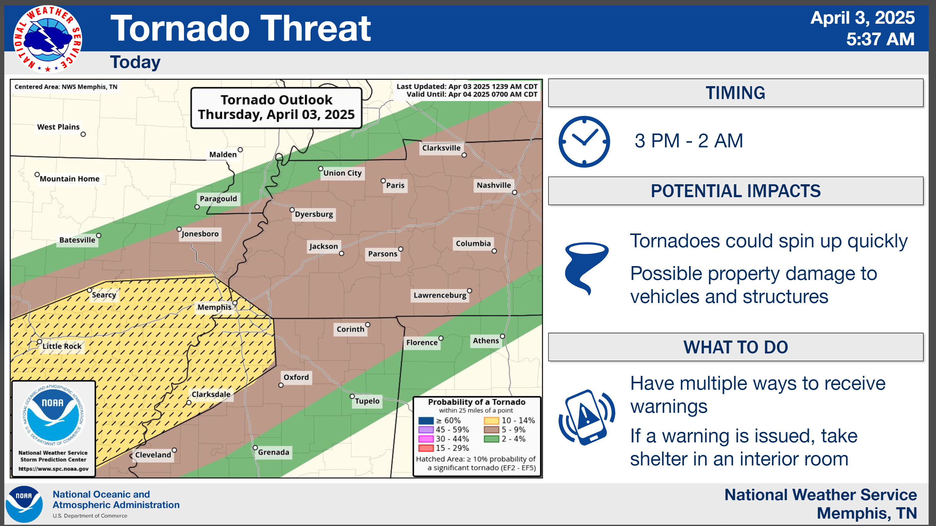
🌪️ Seven-Day Tornado Outlook ⛈️
April 3rd through April 9th
Current risk: YES. There is a risk of tornadoes today into Saturday. Perhaps peak chances will be Friday and Saturday. Monitor updates.
Current confidence level: MEDIUM.
Comment:
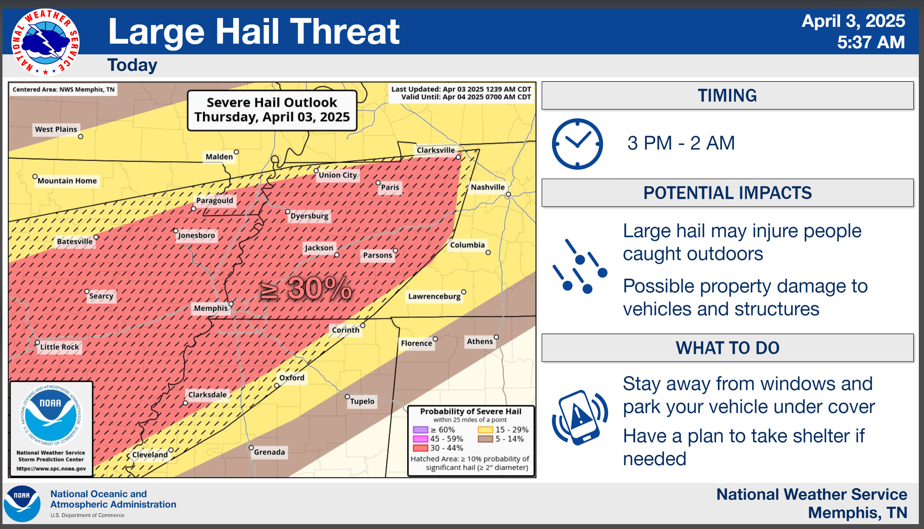
Let’s look at today’s graphics. The risk will be higher tomorrow and perhaps Saturday.
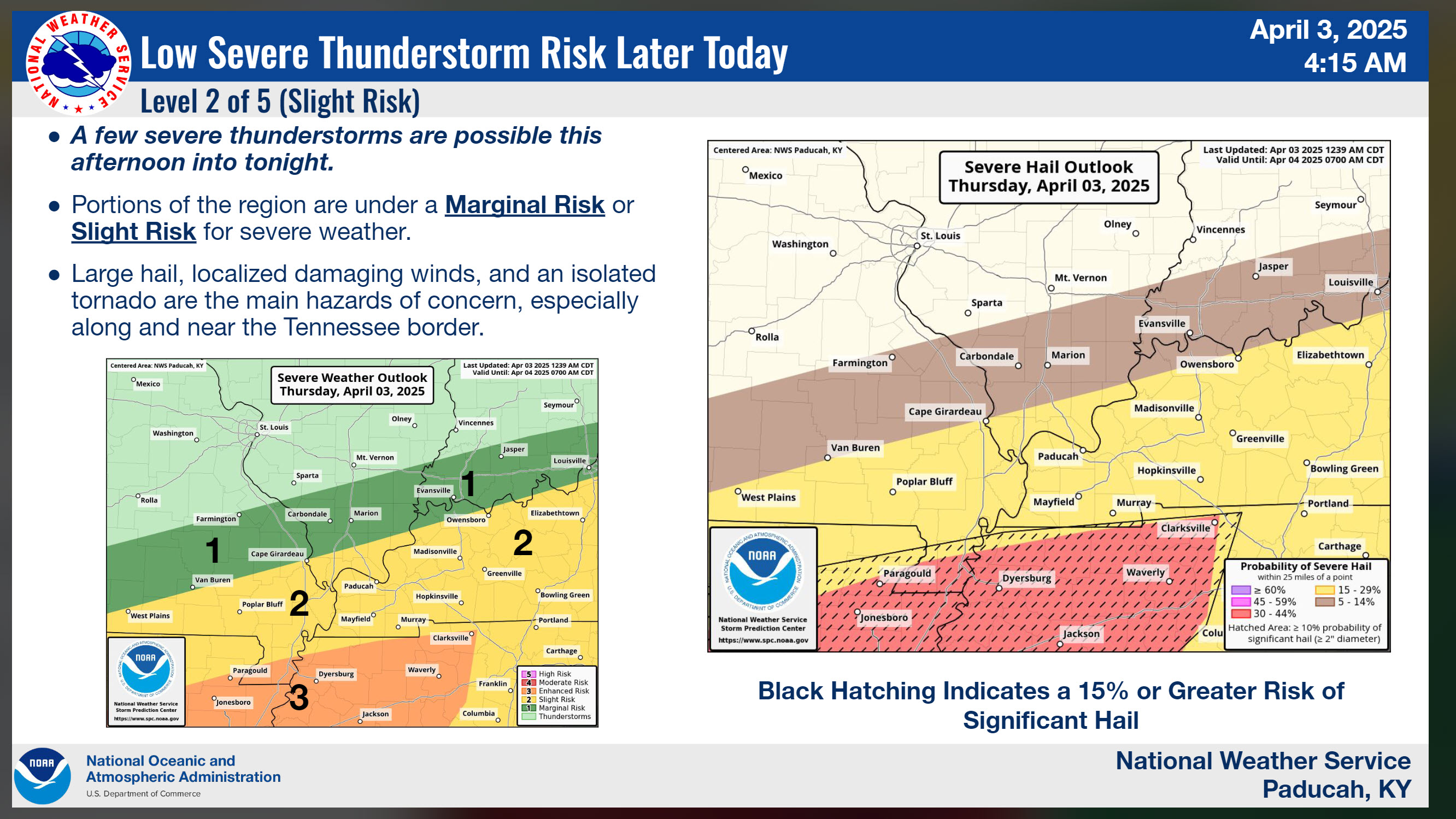
Southern counties for today and tonight.
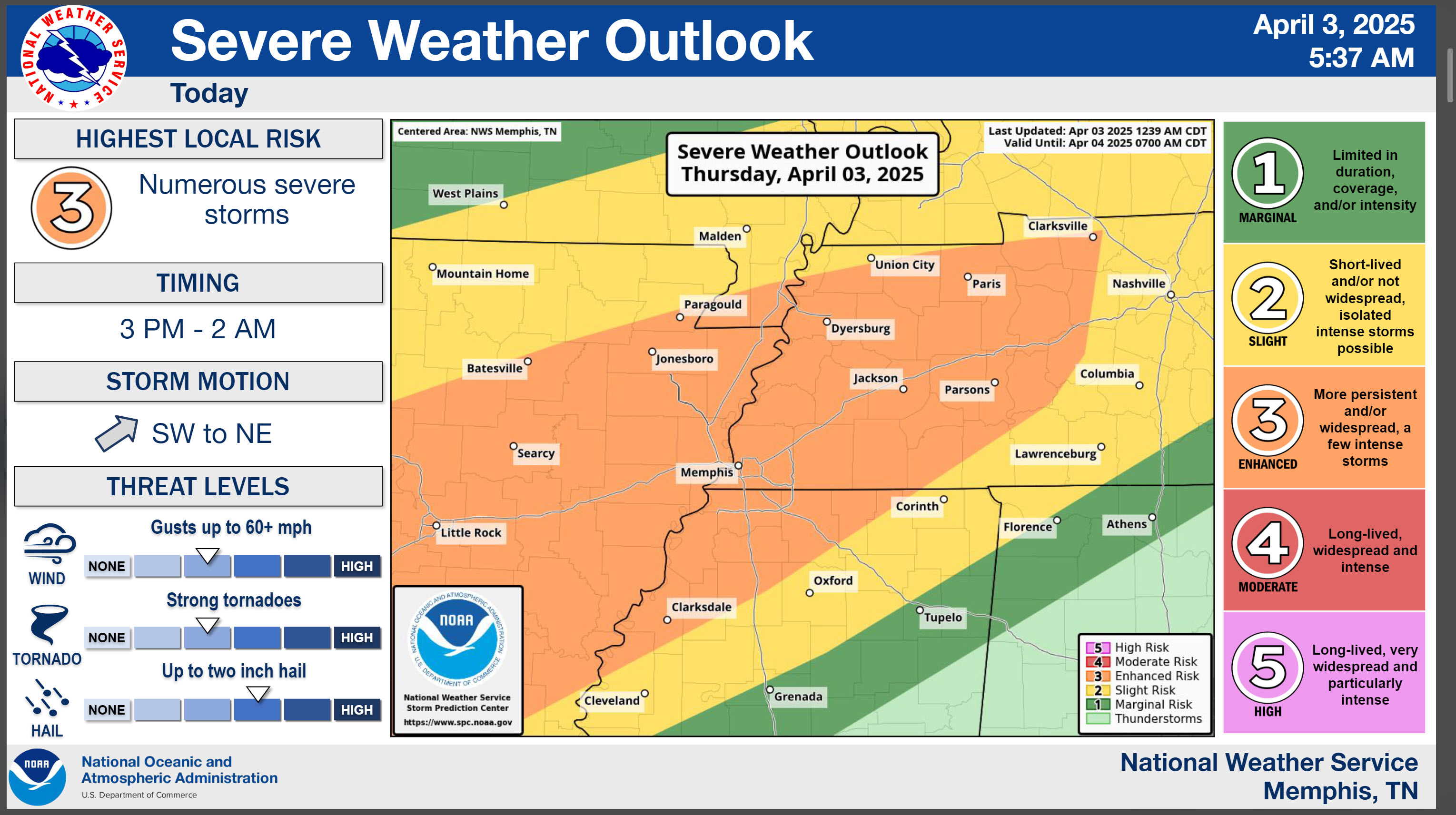
Damaging wind concerns today and tonight
Tornado risk today and tonight
Hail risk today and tonight.
.
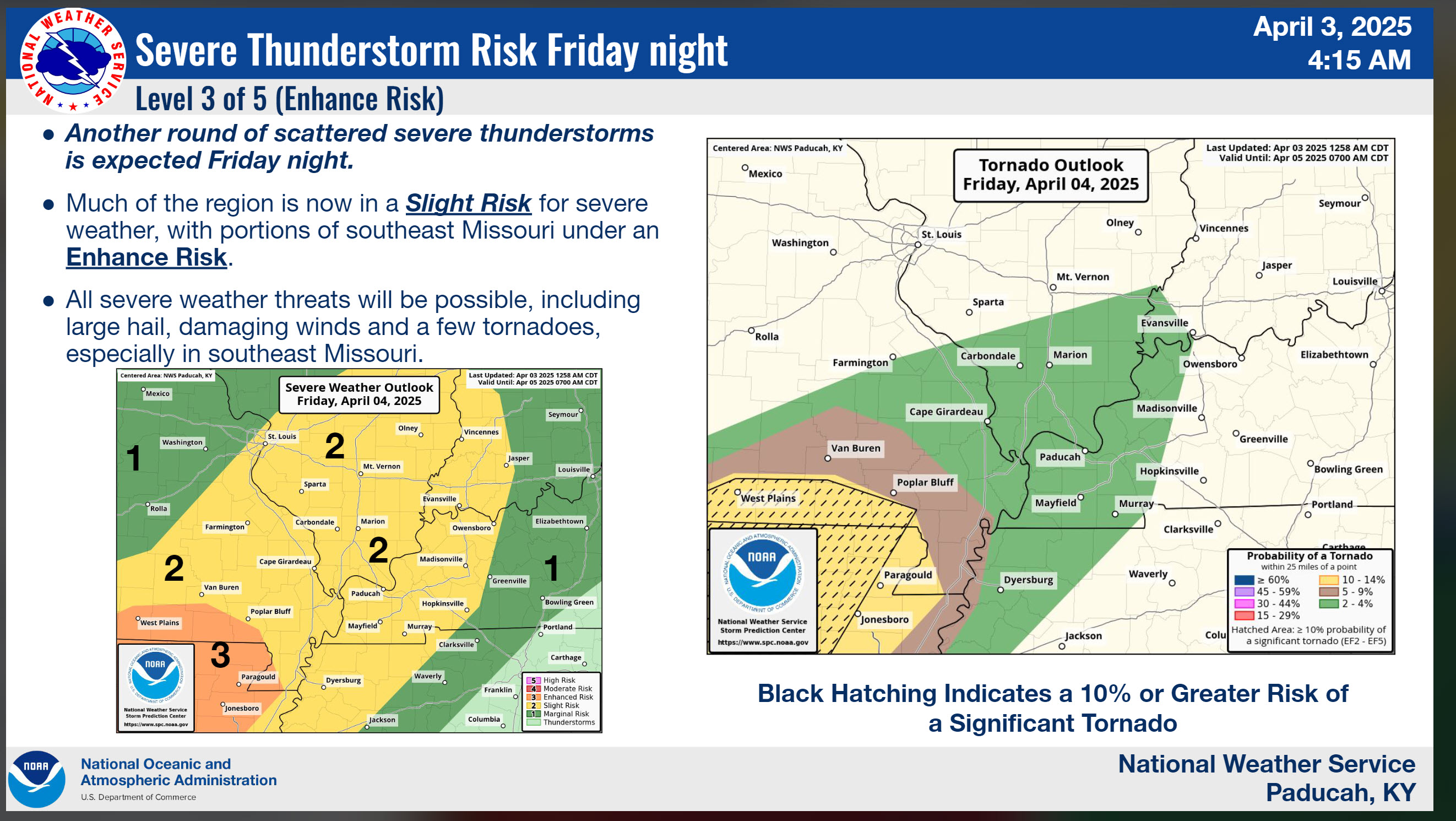
Let’s monitor Friday’s severe risk.
The level three may need to be extended a bit farther northeast. Monitor updates.
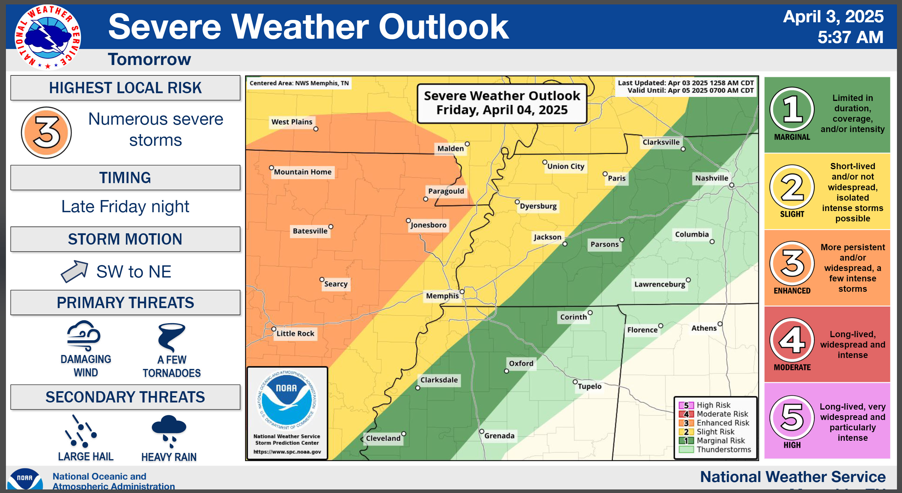
We are monitoring Saturday’s severe weather risk, as well.
.

Seven-Day Hazardous Weather Outlook
1. Is lightning in the forecast? YES. Lightning is likely into Saturday night.
2. Are severe thunderstorms in the forecast? YES. There is a risk of severe weather on Saturday.
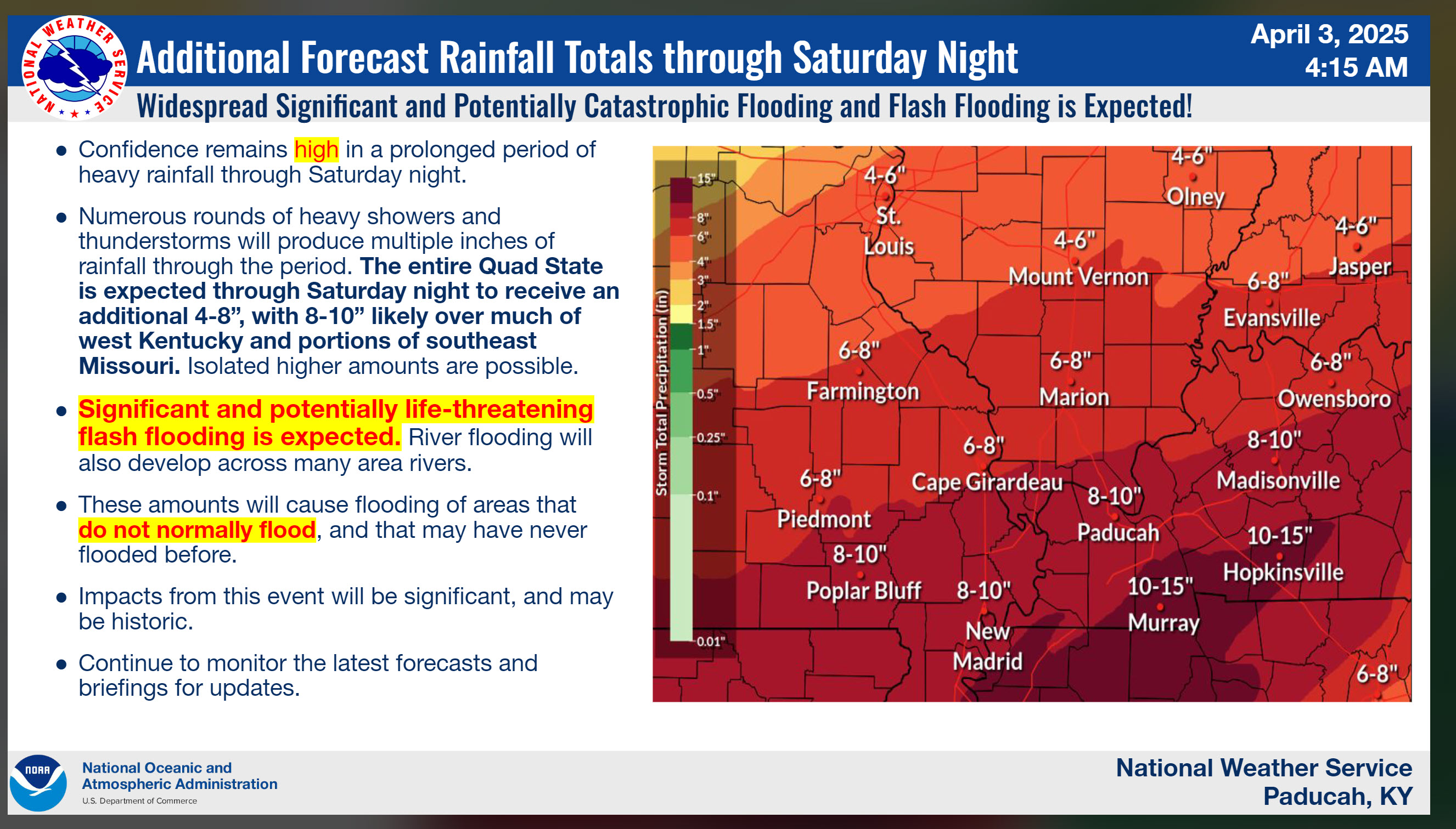
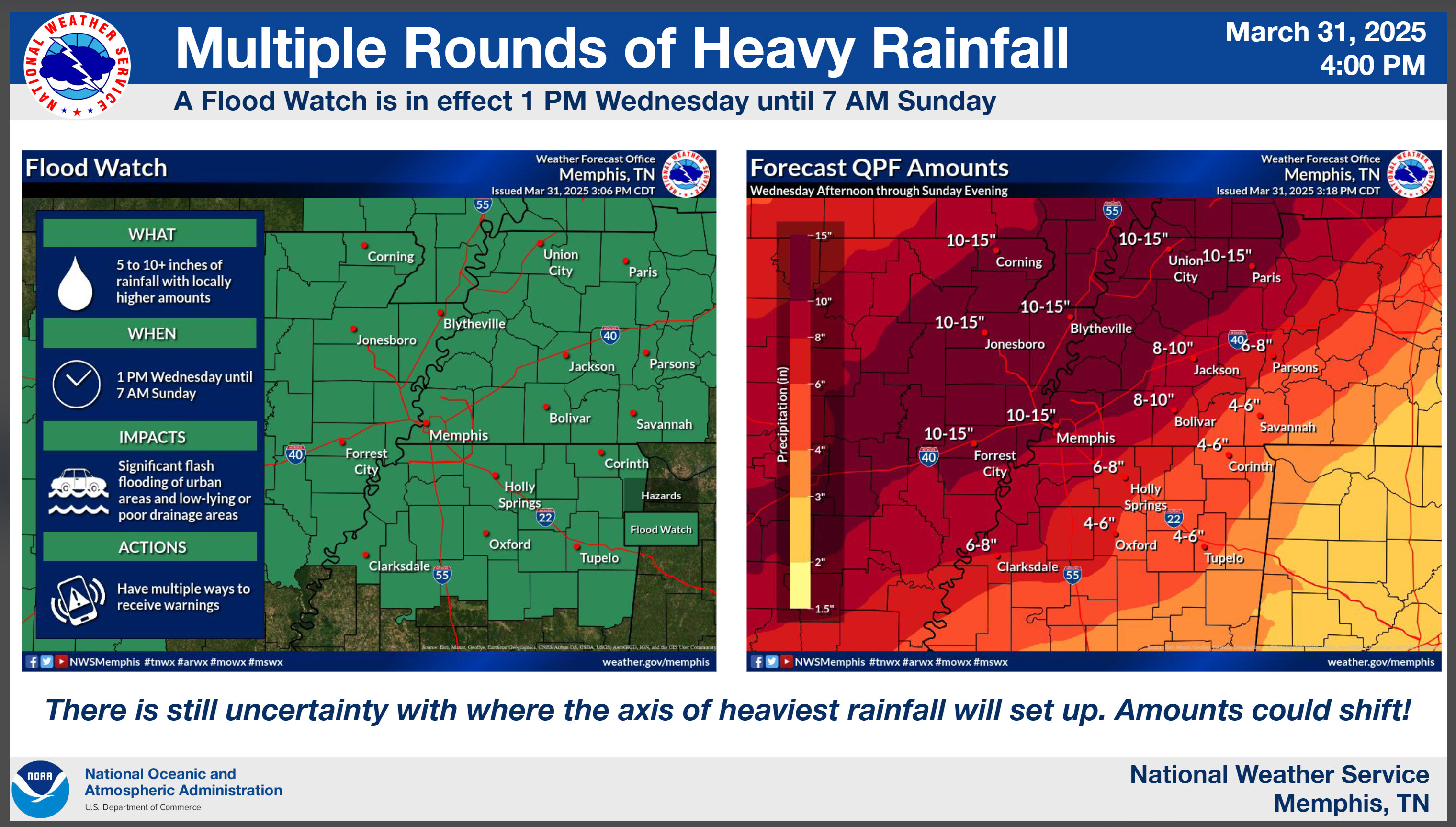
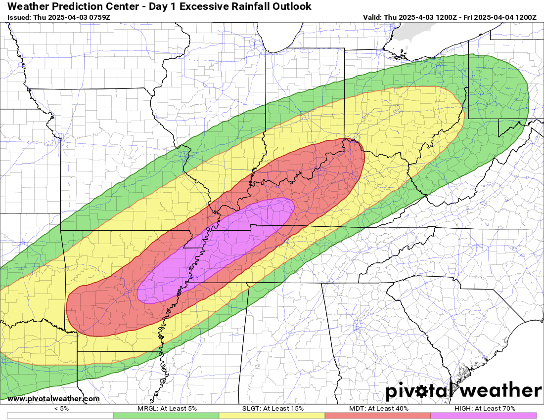
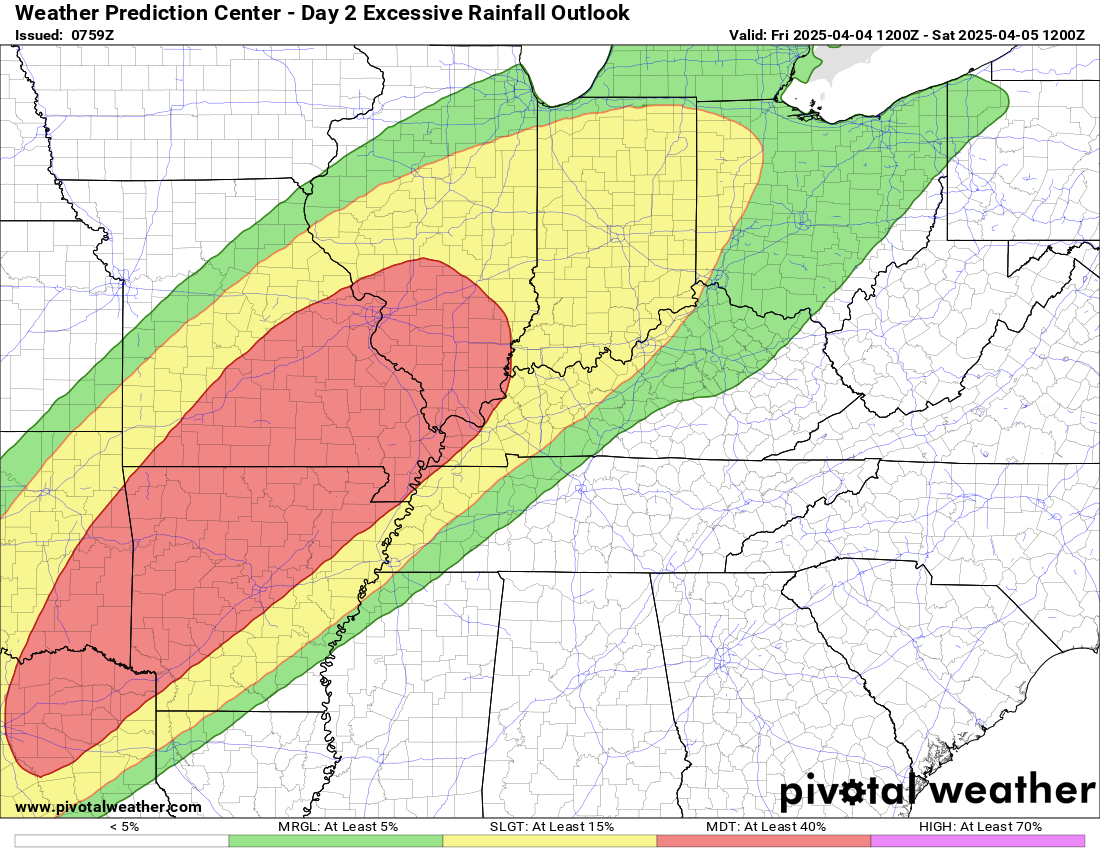
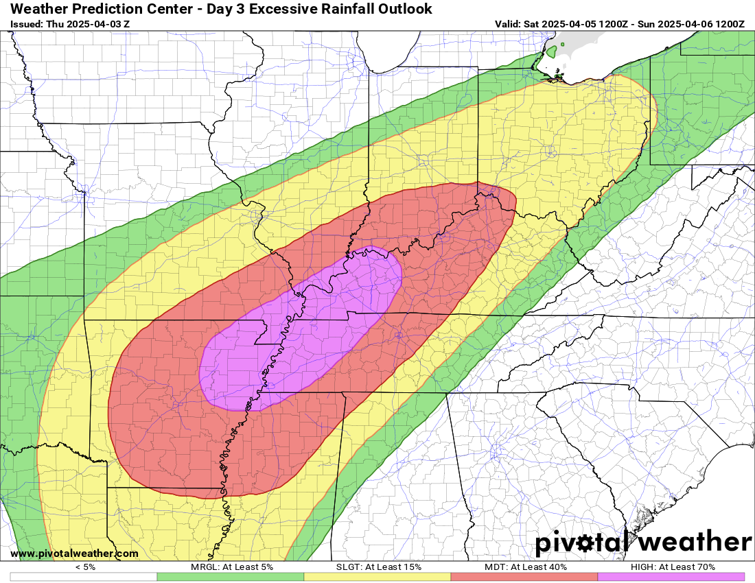
3. Is flash flooding in the forecast? YES. Significant flash flooding is expected. Significant river flooding is likely. Flash flooding is likely Wednesday into Saturday. Locally, very heavy rain is anticipated. Some counties could exceed eight inches of rain. Monitor updates.
I am expecting a widespread 5 to 10 inches of rain. Then, pockets of higher than ten inches will be possible.
This graphic is from the NWS.
Totals will vary, of course. These are extreme numbers.
We will have to see if the 10 to 15-inch band develops. I expect a widespread 5 to 10 inches and then pockets higher than 1o inches.
Remember, with each passing wave of rain, these numbers will decrease. You then add in what has already fallen to the future-cast projections.
.
4. Will non-thunderstorm winds top 40 mph? NO.
5. Will temperatures rise above 90 degrees? NO.
6. Will the heat index rise above 100 degrees? NO.
.
A quick forecast glance. Your 48-hour forecast Graphics


.

.


Forecast discussion.
- An active week of weather ahead. Monitor updates.
- A severe weather threat today into Saturday. Monitor warnings, as always.
- A significant flood and flash flood risk will develop into the weekend.
- Locally, very heavy rain is anticipated into Saturday. Pockets of five to eight+ inches appear likely.
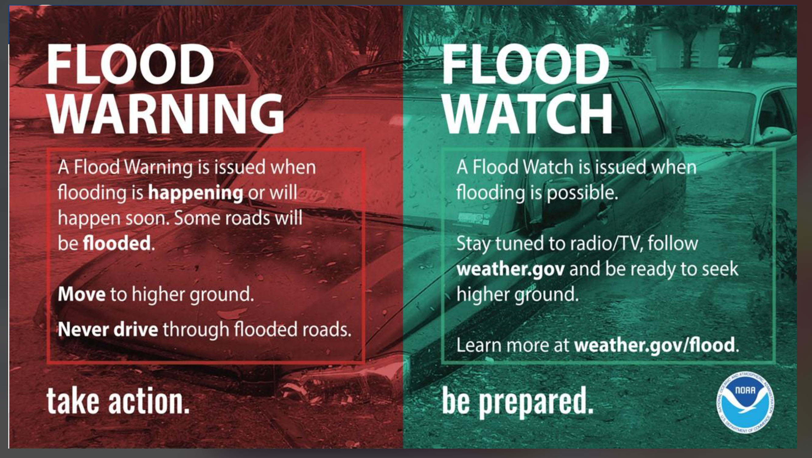
- Monitor watches and warnings. A watch means to pay attention. A WARNING means to seek shelter or take action.
.

.
Good morning,
It was a long 24 hours.
Numerous tornadoes struck the area. There was a lot of damage in some counties. Some fatalities, as well.
Thoughts and prayers go out to everyone impacted.
We have more active weather into Saturday night.
The video covers most of it. Then the info-graphics above.
We are expecting rounds of showers and thunderstorms into Saturday night.
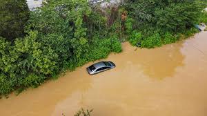
Some very heavy rain totals. Avoid flooded roadways.
Be careful at night in flood-prone areas. Don’t accidentally drive into flood waters.
We also have severe concerns, as mentioned above. Monitor watches and warnings.
Seek shelter if a tornado warning is issued.
I am watching Friday’s threat. The threat may be higher than the Storm Prediction Center shows. They may need to pull the level three risk farther northeast.
I am monitoring that.
Avoid flooded roadways.
Don’t do this. You put yourself and others at risk.
.
Thursday outlook. Another moderate risk.
.
Friday flood outlook. Another moderate risk.
.
Saturday flood outlook. This may be upgraded to a high risk of flooding.
.

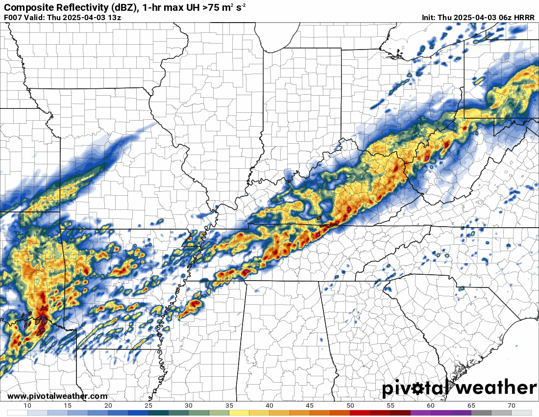
The timestamp (upper left) is in Zulu. 12z=6 am. 18z=12 pm. 00z=6 pm.
Double-click the animation to enlarge it.
Double-click the animation to enlarge it.
This is the Hrrr model.
.
.
.
Click here if you would like to return to the top of the page.
.Average high temperatures for this time of the year are around 62 degrees.
Average low temperatures for this time of the year are around 40 degrees.
Average precipitation during this time period ranges from 0.90″ to 1.20″
Six to Ten Day Outlook.
Blue is below average. Red is above average. The no color zone represents equal chances.
Average highs for this time of the year are in the lower 60s. Average lows for this time of the year are in the lower 40s.

Green is above average precipitation. Yellow and brown favors below average precipitation. Average precipitation for this time of the year is around one inch per week.

.

Average low temperatures for this time of the year are around 42 degrees.
Average precipitation during this time period ranges from 0.90″ to 1.20″
.
Eight to Fourteen Day Outlook.
Blue is below average. Red is above average. The no color zone represents equal chances.

Green is above average precipitation. Yellow and brown favors below average precipitation. Average precipitation for this time of the year is around one inch per week.

.
.
.
We have a new service to complement your www.weathertalk.com subscription. This does NOT replace www.weathertalk.com It is simply another tool for you to receive severe weather information.
.
.
Radars and Lightning Data
Interactive-city-view radars. Clickable watches and warnings.
https://wtalk.co/B3XHASFZ
Old legacy radar site (some of you like it better)
https://weatherobservatory.com/weather-radar.htm
If the radar is not updating then try another one. If a radar does not appear to be refreshing then hit Ctrl F5. You may also try restarting your browser.
Backup radar site in case the above one is not working.
https://weathertalk.com/morani
Regional Radar
https://imagery.weathertalk.com/prx/RadarLoop.mp4
** NEW ** Zoom radar with chaser tracking abilities!
ZoomRadar
If the radar is not working, then email me: Email me at beaudodson@usawx.com
.
We do have some sponsors! Check them out.
Roof damage from recent storms? Link – Click here
INTEGRITY ROOFING AND EXTERIORS!
⛈️ Roof or gutter damage from recent storms? Today’s weather is sponsored by Integrity Roofing. Check out their website at this link https://www.ourintegritymatters.com/

![]()
![]()
![]()
Make sure you have three to five ways of receiving your severe weather information.
Weather Talk is one of those ways! Now, I have another product for you and your family.

.
Want to add more products to your Beau Dodson Weather App?
Receive daily videos, weather blog updates on normal weather days and severe weather and winter storm days, your county by county weather forecast, and more!
Here is how to do add those additional products to your app notification settings!
Here is a video on how to update your Beau Dodson Weather payment.
The app is for subscribers. Subscribe at www.weathertalk.com/welcome then go to your app store and search for WeatherTalk
Subscribers, PLEASE USE THE APP. ATT and Verizon are not reliable during severe weather. They are delaying text messages.
The app is under WeatherTalk in the app store.

Apple users click here

Android users click here
.
Radars and Lightning Data
Interactive-city-view radars. Clickable watches and warnings.
https://wtalk.co/B3XHASFZ
Old legacy radar site (some of you like it better)
https://weatherobservatory.com/weather-radar.htm
If the radar is not updating then try another one. If a radar does not appear to be refreshing then hit Ctrl F5. You may also try restarting your browser.
Backup radar site in case the above one is not working.
https://weathertalk.com/morani
Regional Radar
https://imagery.weathertalk.com/prx/RadarLoop.mp4
** NEW ** Zoom radar with chaser tracking abilities!
ZoomRadar
Lightning Data (zoom in and out of your local area)
https://wtalk.co/WJ3SN5UZ
Not working? Email me at beaudodson@usawx.com
National map of weather watches and warnings. Click here.
Storm Prediction Center. Click here.
Weather Prediction Center. Click here.
.

Live lightning data: Click here.
Real time lightning data (another one) https://map.blitzortung.org/#5.02/37.95/-86.99
Our new Zoom radar with storm chases
.
.

Interactive GOES R satellite. Track clouds. Click here.
GOES 16 slider tool. Click here.
College of DuPage satellites. Click here
.

Here are the latest local river stage forecast numbers Click Here.
Here are the latest lake stage forecast numbers for Kentucky Lake and Lake Barkley Click Here.
.
.
Find Beau on Facebook! Click the banner.


 .
.