

.
I have some question-and-answer threads over on the Facebook page. Link to those threads CLICK HERE
Or email me at beaudodsonweather@gmail.com

.
2:30 PM Video Update
.
2:25 PM
We are waiting on a tornado watch to be issued.
Charge your devices.
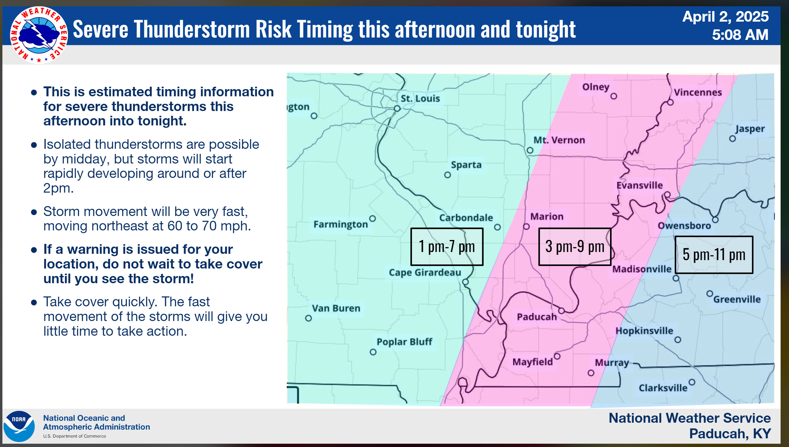
Storms will be moving at speeds of 50 to 80 mph. Very fast. That does not allow much time to seek shelter.
Be prepared.
.
10 AM NWS Update
.
9 AM NWS Paducah, KY Video Briefing
Beau’s Video Update
.
Stay updated on the latest watches and warnings.
I expect there to be numerous app updates. Monitor them. Have a severe weather safety plan.
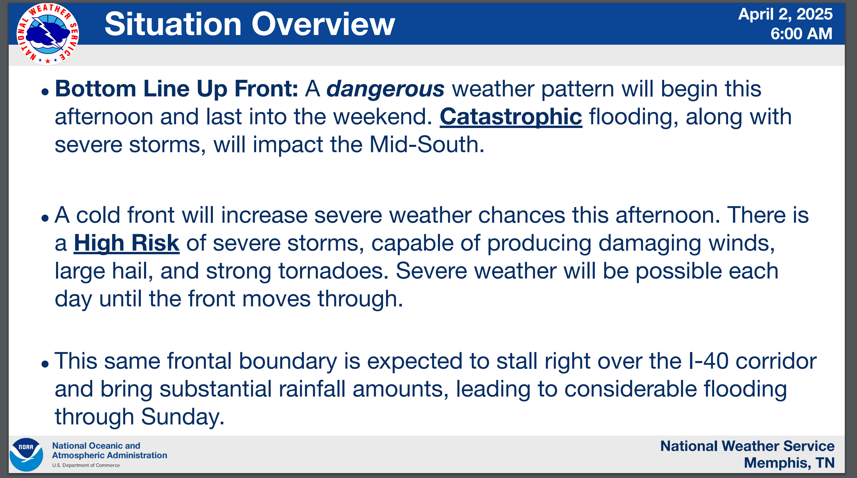
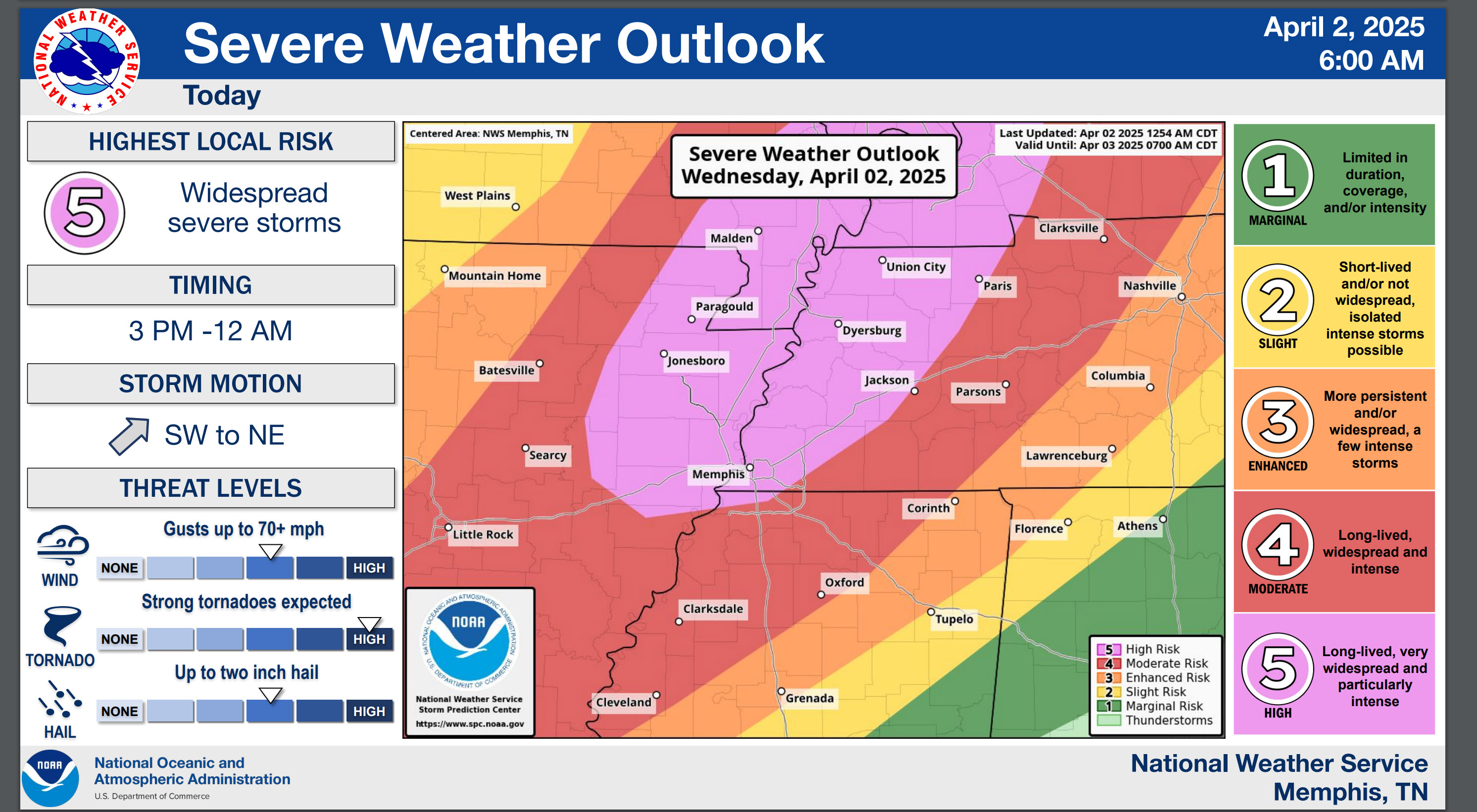
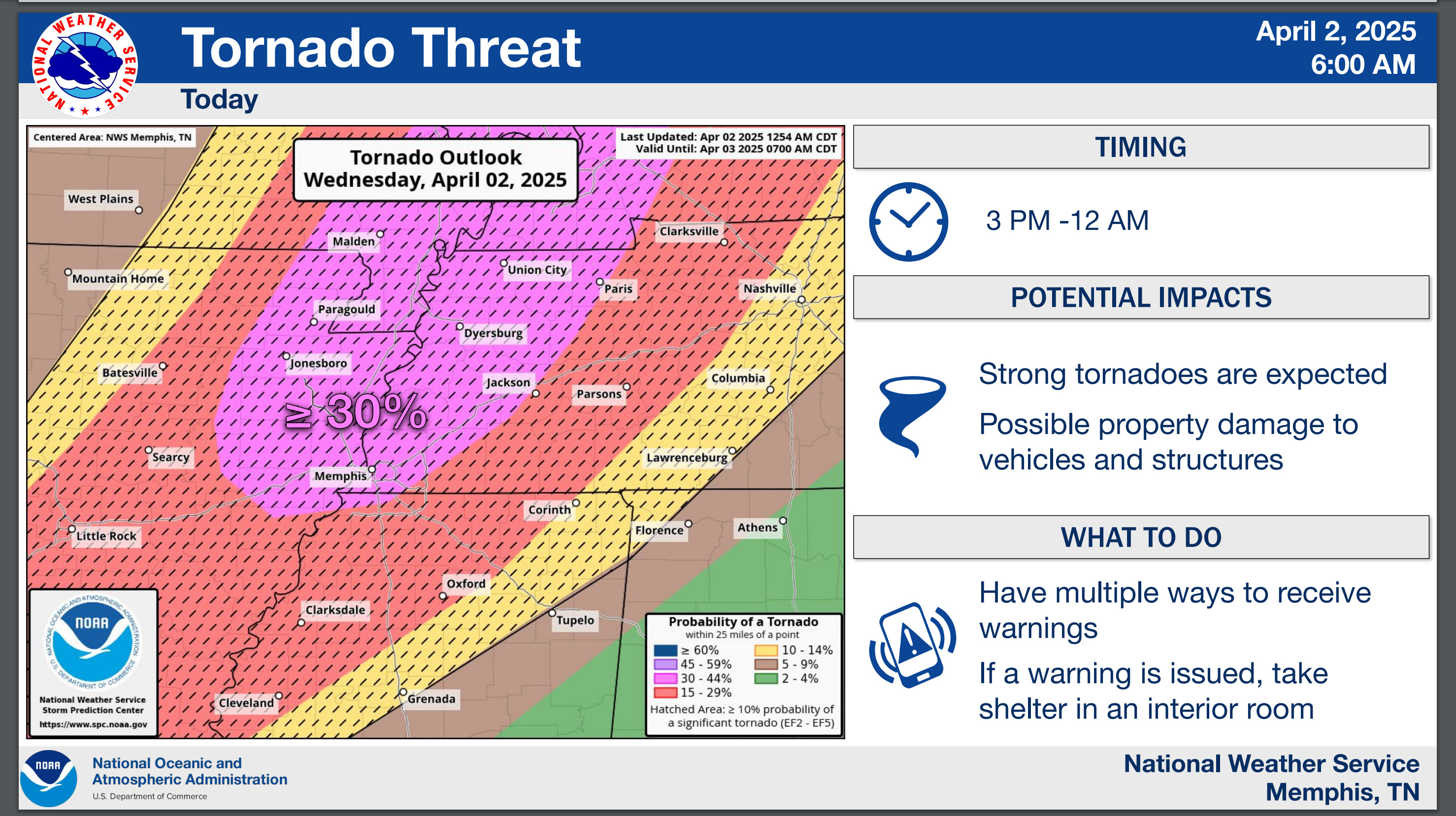
7 AM update
These graphics are from the Memphis, TN NWS
Scroll down for more graphics for the rest of the area.
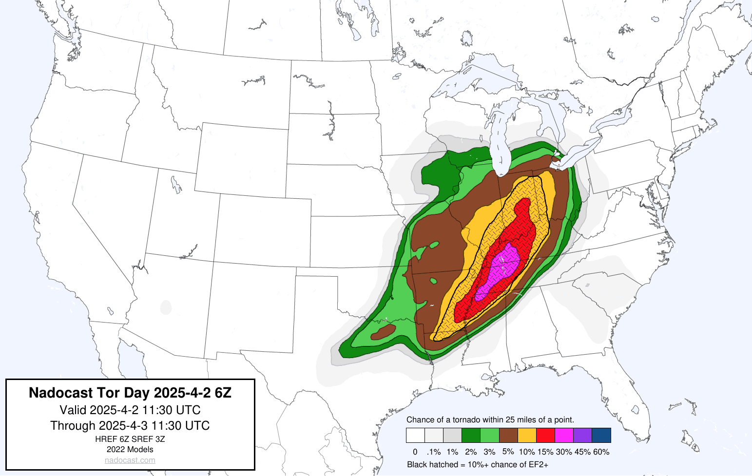
Severe weather outlook
Tornado risk
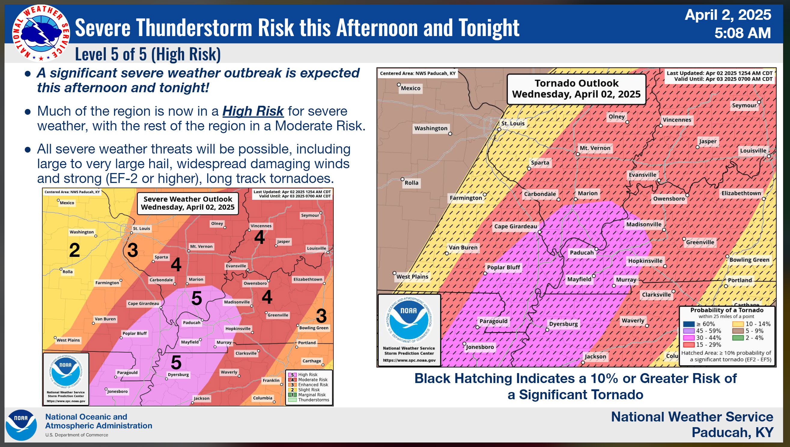
Here are some additional info-graphics.
We have a significant risk of severe weather later today and tonight.
Some of the storms could produce damaging wind, large hail, and tornadoes. We can’t rule out some long-tracked tornadoes. Monitor your severe weather alerts. Have a safety plan.
If we have a solid line of storms, then the tornado risk will be lower. Supercells would have a higher risk of tornadoes.
Supercells tend to be by themselves on the radar. They can pull in more energy.
That is one aspect of the forecast that we will need to monitor. Supercells? Line of storms? That remains the question.
Perhaps we will have a mixture. Both supercells and lines of storms.
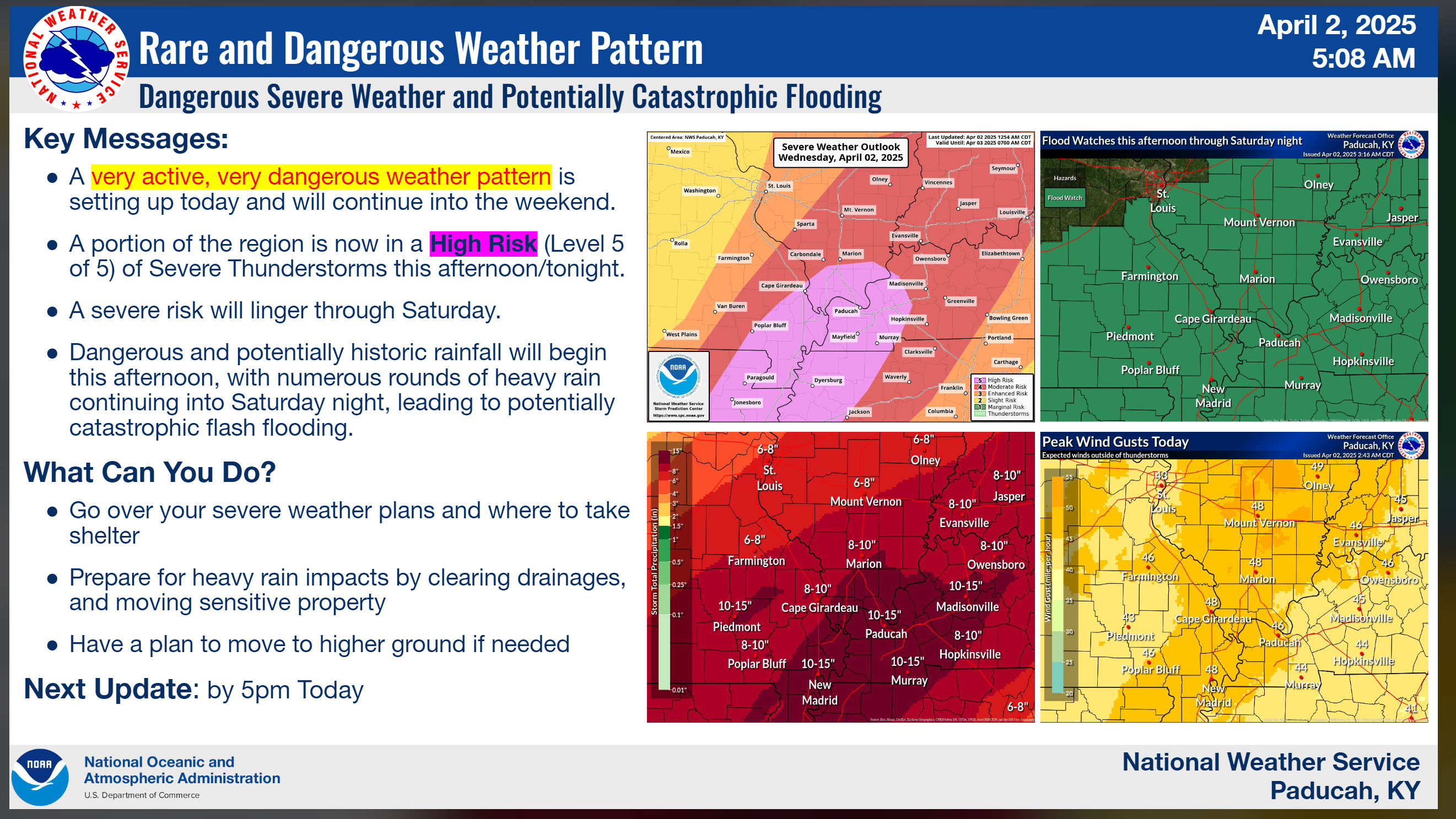
We are concerned about flash flooding, of course.
As you know, some big rainfall totals are possible.
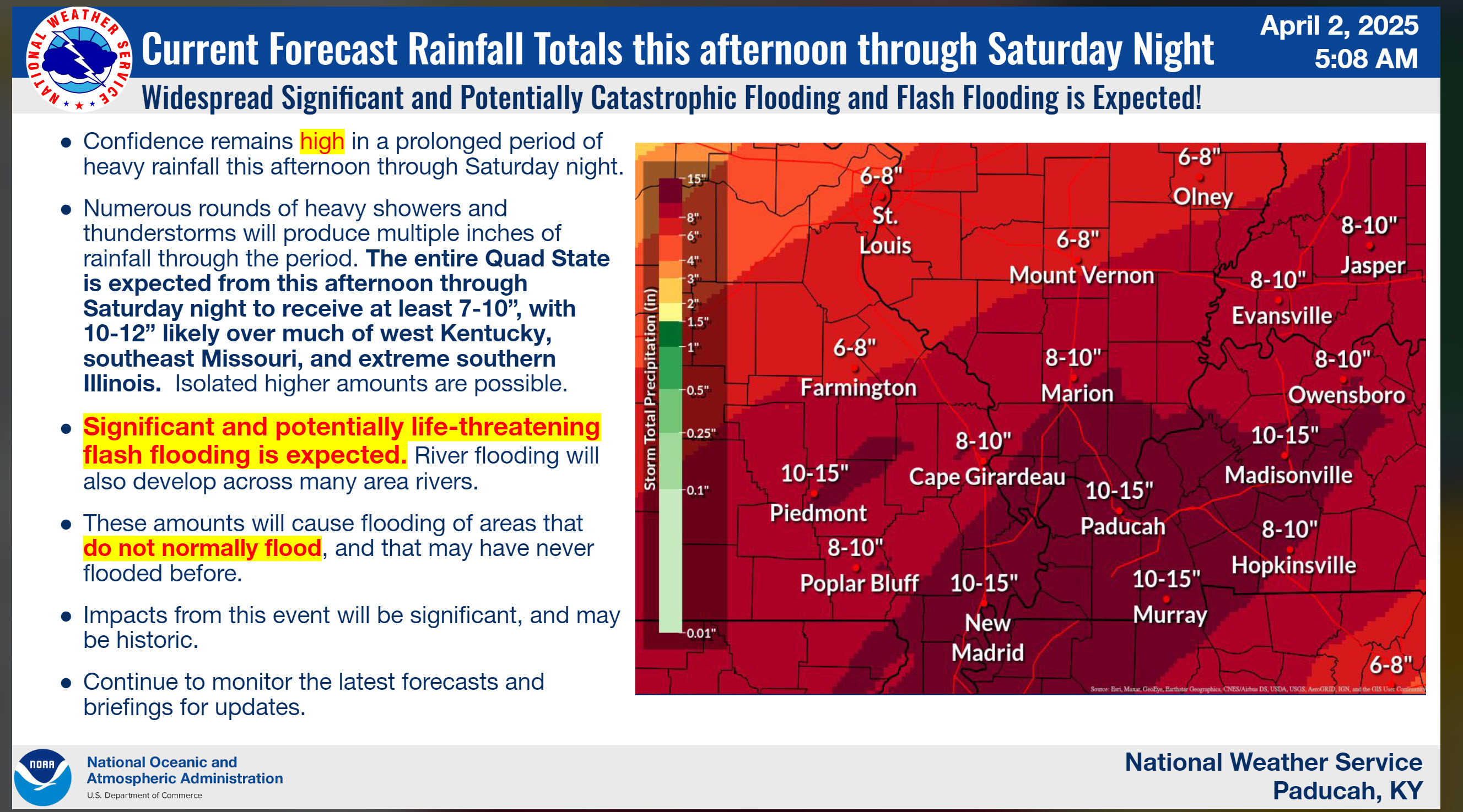
Here is my forecast for each county. Rainfall totals.
Here is the latest rainfall outlook for each county.

Issued Tuesday at noon.

Monitor watches and warnings over the coming days.

This event will begin on Wednesday afternoon and end on Sunday morning.  On and off periods of showers and storms.  It won't rain all the time, but intervals of precipitation.  Some heavy.

Flooding is likely.  There will be periods of training thunderstorms.  Where those training storms occur, you can pick up 2 to 3 inches per hour.  That would enhance the flash flood threat.

The region will experience numerous road closures due to water, especially on Friday and Saturday.

Avoid flooded roadways.

Find your county below, north to south.

Ste Genevieve and Perry County, MO.  Randolph, Jackson, Perry, Franklin, Jefferson, Hamilton, and White County in IL.

The current forecast is for
100% chance of 1 to 3 inches of rain.
90% chance of 3 to 5 inches of rain.
70% chance of 5 to 8 inches of rain.
A 40% chance of 8 to 10 inches of rain.
A 20% chance of greater than 10 inches of rain.

------

Bollinger and Cape Girardeau County in MO. Union, Williamson, Saline, and Gallatin County in IL.  Union, Henderson, and Daviess County in KY.

The current forecast is for
100% chance of 3 to 5 inches of rain.
70% chance of 5 to 8 inches of rain.
A 40% chance of 8 to 10 inches of rain.
A 30% chance of greater than 10 inches of rain.

------

Butler, Stoddard, Scott County in MO. Alexander, Pulaski, Johnson, Pope, Hardin, and Massac County, IL. Ballard, McCracken, Livingston, Crittenden, Webster, McLean, Lyon, Caldwell, Hopkins, and Muhlenberg County.

The current forecast is for
100% chance of 4 to 6 inches of rain.
90% chance of 6 to 8 inches of rain.
70% chance of 8 to 10 inches of rain.
A 50% chance of 10 to 12 inches of rain.
A 40% chance of 12 to 15 inches of rain.
A 20% chance of greater than 15 inches of rain.

------

Dunklin, Pemiscot, New Madrid, and Mississippi County, MO. Lake, Obion, Weakley, and Henry County, TN.  Fulton, Hickman, Carlisle, Graves, Marshall, Calloway, Trigg, Christian, and Todd County in KY.

100% chance of 4 to 6 inches of rain.
90% chance of 6 to 8 inches of rain.
70% chance of 8 to 10 inches of rain.
A 50% chance of 10 to 12 inches of rain.
A 40% chance of 12 to 15 inches of rain.
A 20% chance of greater than 15 inches of rain.


Avoid flooded roadways.

The timestamp (upper left) is in Zulu. 12z=6 am. 18z=12 pm. 00z=6 pm.
Double-click the animation to enlarge it.
Double-click the animation to enlarge it.
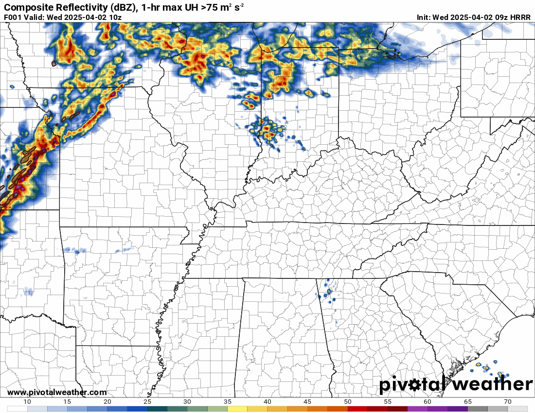
This is the Hrrr model for Wednedsay.
.
If you have not signed up for this, then consider doing so.
Weather Call will call you when a warning is issued. This is useful when we have tornadoes at night!
🌪️ NEW SERVICE 🌪️
I have partnered with WeatherCall to bring you an added layer of protection.
.
.
We have a new service to complement your www.weathertalk.com subscription. This does NOTreplace www.weathertalk.com. It is simply another tool that allows you to receive severe weather information.
.


.

Radars and Lightning Data
Interactive-city-view radars. Clickable watches and warnings.
https://wtalk.co/B3XHASFZ
Old legacy radar site (some of you like it better)
https://weatherobservatory.com/weather-radar.htm
If the radar is not updating then try another one. If a radar does not appear to be refreshing then hit Ctrl F5. You may also try restarting your browser.
Backup radar site in case the above one is not working.
https://weathertalk.com/morani
Regional Radar
https://imagery.weathertalk.com/prx/RadarLoop.mp4
Zoom National Radar
ZoomRadar
The timestamp (upper left) is in Zulu. 12z=6 am. 18z=12 pm. 00z=6 pm.
Double-click the animation to enlarge it.
Double-click the animation to enlarge it.
This is the Hrrr model for Wednedsay.
.
We do have some sponsors! Check them out.
Roof damage from recent storms? Link – Click here
INTEGRITY ROOFING AND EXTERIORS!
⛈️ Roof or gutter damage from recent storms? Today’s weather is sponsored by Integrity Roofing. Check out their website at this link https://www.ourintegritymatters.com/

![]()
![]()
![]()
Make sure you have three to five ways of receiving your severe weather information.
Weather Talk is one of those ways! Now, I have another product for you and your family.

.
Want to add more products to your Beau Dodson Weather App?
Receive daily videos, weather blog updates on normal weather days and severe weather and winter storm days, your county by county weather forecast, and more!
Here is how to do add those additional products to your app notification settings!
Here is a video on how to update your Beau Dodson Weather payment.
The app is for subscribers. Subscribe at www.weathertalk.com/welcome then go to your app store and search for WeatherTalk
Subscribers, PLEASE USE THE APP. ATT and Verizon are not reliable during severe weather. They are delaying text messages.
The app is under WeatherTalk in the app store.

Apple users click here

Android users click here
.
Radars and Lightning Data
Interactive-city-view radars. Clickable watches and warnings.
https://wtalk.co/B3XHASFZ
Old legacy radar site (some of you like it better)
https://weatherobservatory.com/weather-radar.htm
If the radar is not updating then try another one. If a radar does not appear to be refreshing then hit Ctrl F5. You may also try restarting your browser.
Backup radar site in case the above one is not working.
https://weathertalk.com/morani
Regional Radar
https://imagery.weathertalk.com/prx/RadarLoop.mp4
** NEW ** Zoom radar with chaser tracking abilities!
ZoomRadar
Lightning Data (zoom in and out of your local area)
https://wtalk.co/WJ3SN5UZ
Not working? Email me at beaudodson@usawx.com
National map of weather watches and warnings. Click here.
Storm Prediction Center. Click here.
Weather Prediction Center. Click here.
.

Live lightning data: Click here.
Real time lightning data (another one) https://map.blitzortung.org/#5.02/37.95/-86.99
Our new Zoom radar with storm chases
.
.

Interactive GOES R satellite. Track clouds. Click here.
GOES 16 slider tool. Click here.
College of DuPage satellites. Click here
.

Here are the latest local river stage forecast numbers Click Here.
Here are the latest lake stage forecast numbers for Kentucky Lake and Lake Barkley Click Here.
.
.
Find Beau on Facebook! Click the banner.


 .
.