
If you have not signed up for this, then consider doing so.
Weather Call will call you when a warning is issued. This is useful when we have tornadoes at night!
🌪️ NEW SERVICE 🌪️
I have partnered with WeatherCall to bring you an added layer of protection.
.
.
We have a new service to complement your www.weathertalk.com subscription. This does NOT replace www.weathertalk.com. It is simply another tool that allows you to receive severe weather information.
.


.

Radars and Lightning Data
Interactive-city-view radars. Clickable watches and warnings.
https://wtalk.co/B3XHASFZ
Old legacy radar site (some of you like it better)
https://weatherobservatory.com/weather-radar.htm
If the radar is not updating then try another one. If a radar does not appear to be refreshing then hit Ctrl F5. You may also try restarting your browser.
Backup radar site in case the above one is not working.
https://weathertalk.com/morani
Regional Radar
https://imagery.weathertalk.com/prx/RadarLoop.mp4
Zoom National Radar
ZoomRadar
.

.
I have some question-and-answer threads over on the Facebook page. Link to those threads CLICK HERE
Or email me at beaudodsonweather@gmail.com
.

🌪️ Seven-Day Tornado Outlook ⛈️
April 1st to April 7th
Current risk: YES. There is a risk of tornadoes on Wednesday and Wednesday night.
We may have a risk on Thursday into Saturday, as well. This will depend on where the front stalls. Monitor updates.
Current confidence level: MEDIUM.
Comment: A strong storm system will push into the region on Wednesday. The atmosphere appears primed for severe weather.
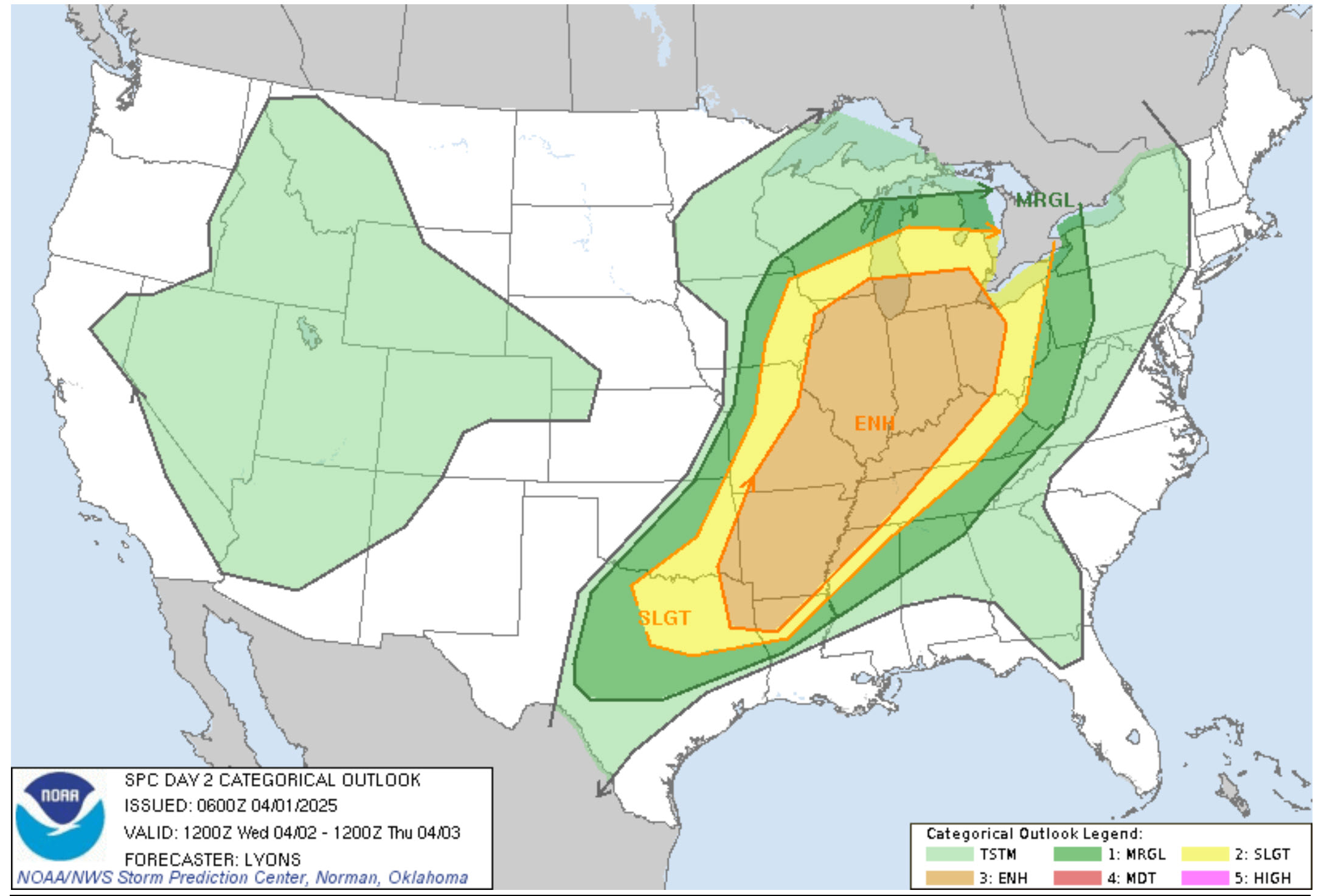
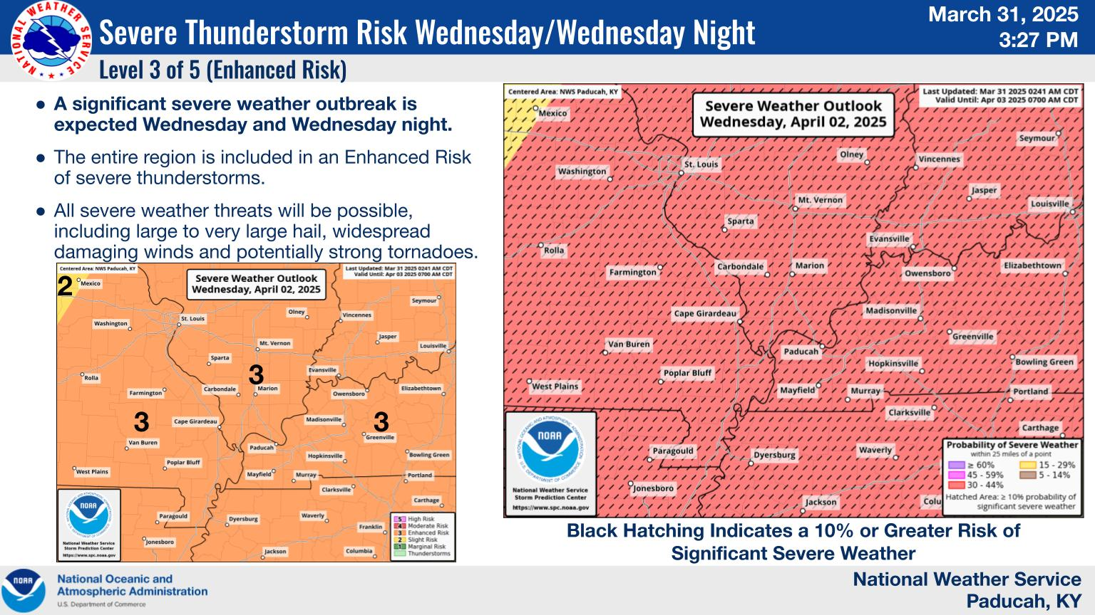
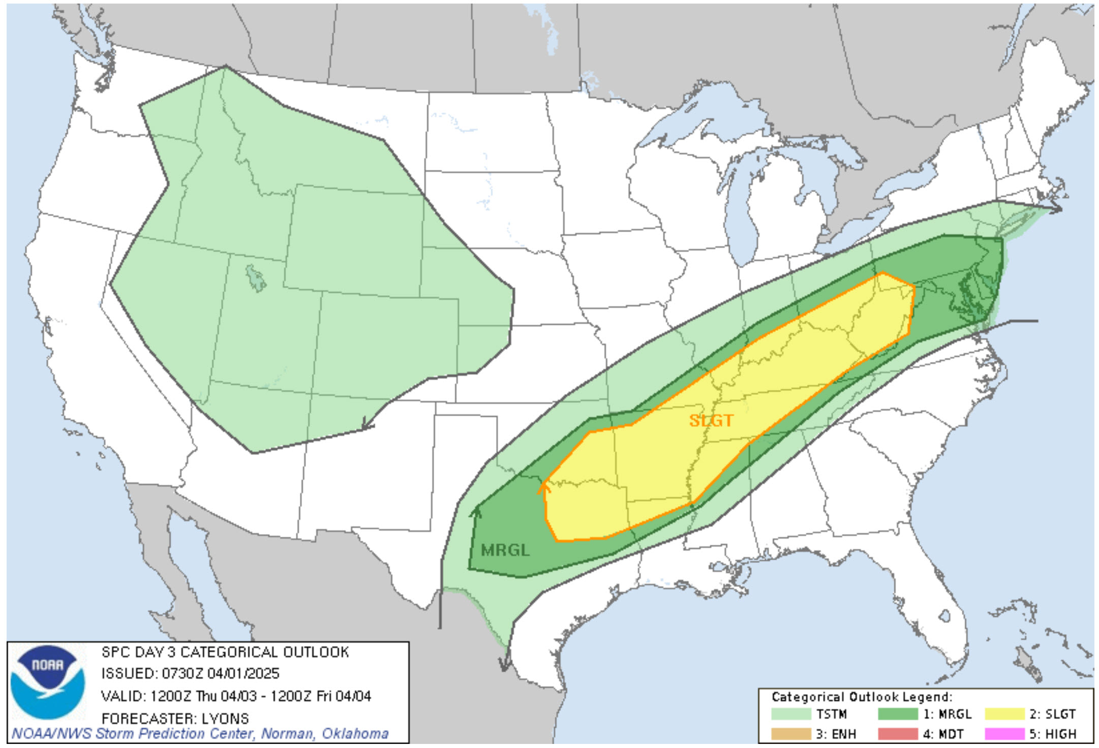
This is the Wednesday severe weather risk. We are in a level three out of five risk. One being the lowest. Five being the highest.
Don’t get too caught up in the colors and numbers. We will have severe weather. Just a matter of how big of an event.
.
The hatched zone means a higher-end severe weather event is possible.
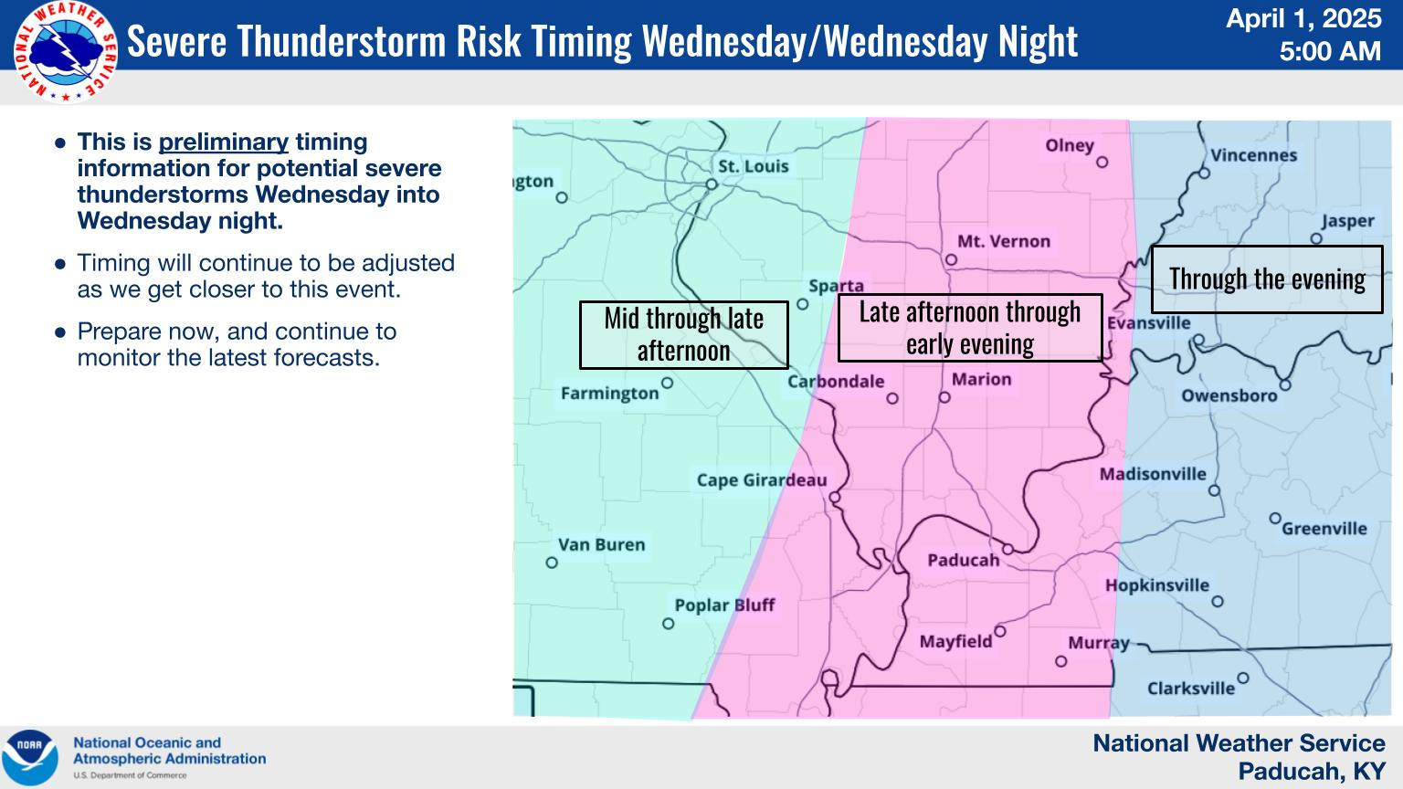
The primary concern will be the afternoon hours into the overnight hours.
This graphic is from the Paducah, Kentucky, NWS/NOAA
.
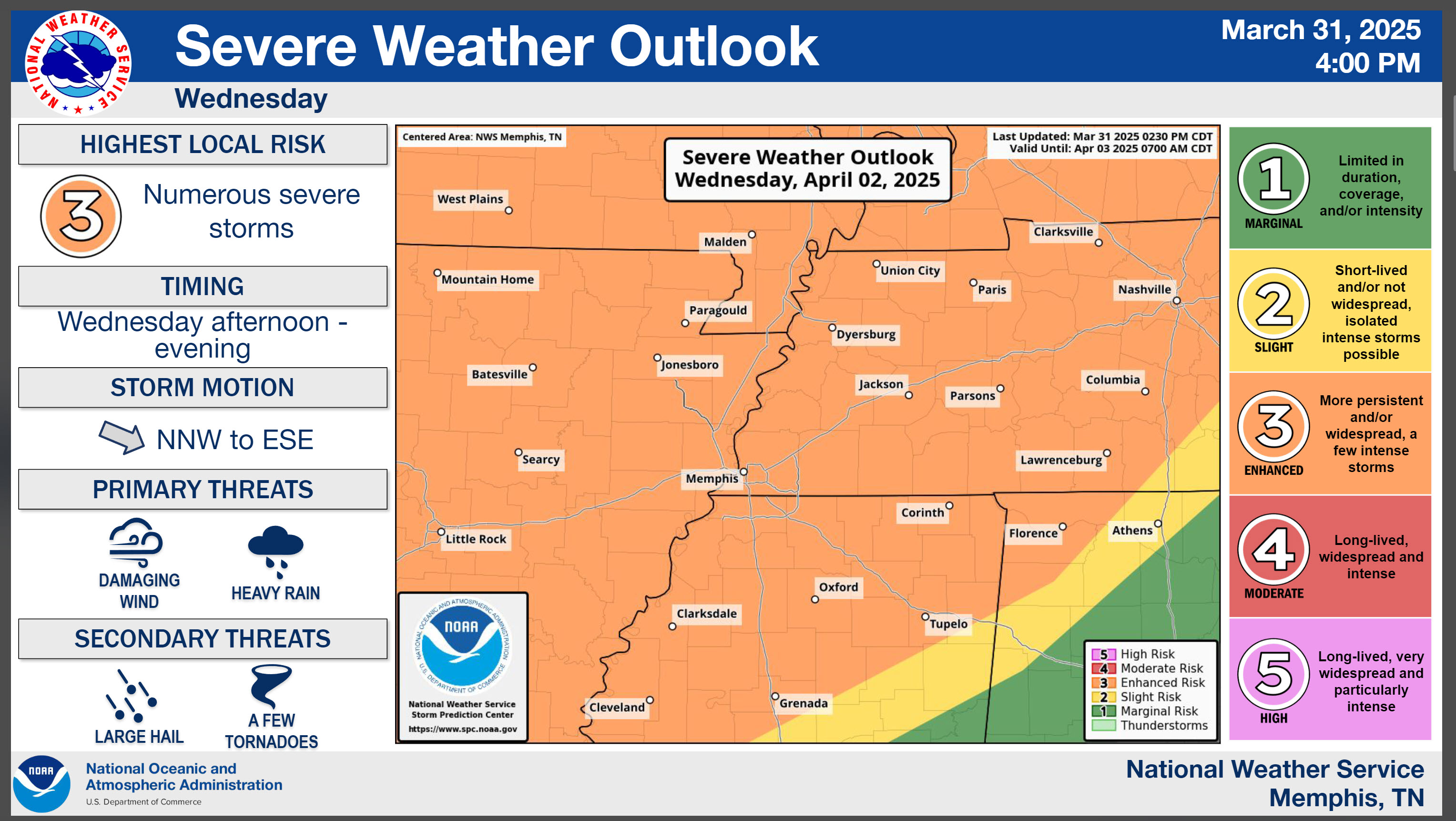
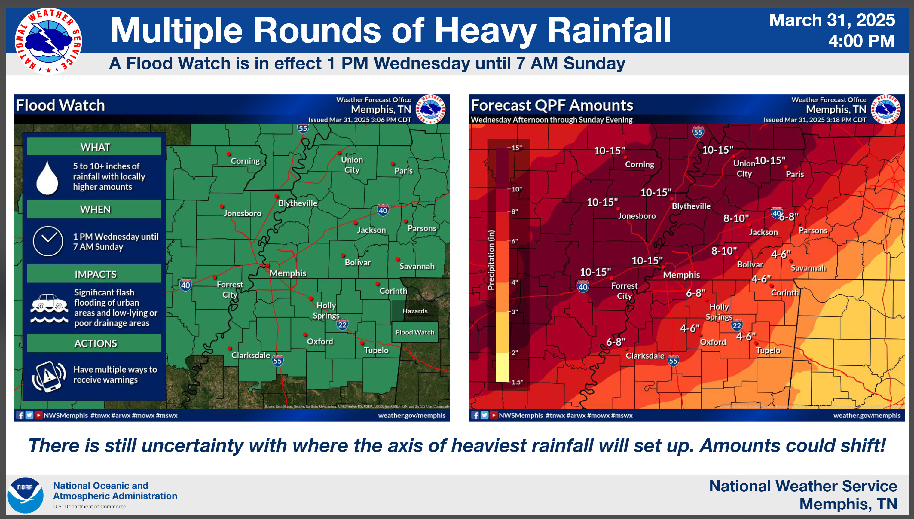
This graphic is from the Memphis, Tennessee, NWS. This covers our southern counties.
Tornado outlook for Wednesday.
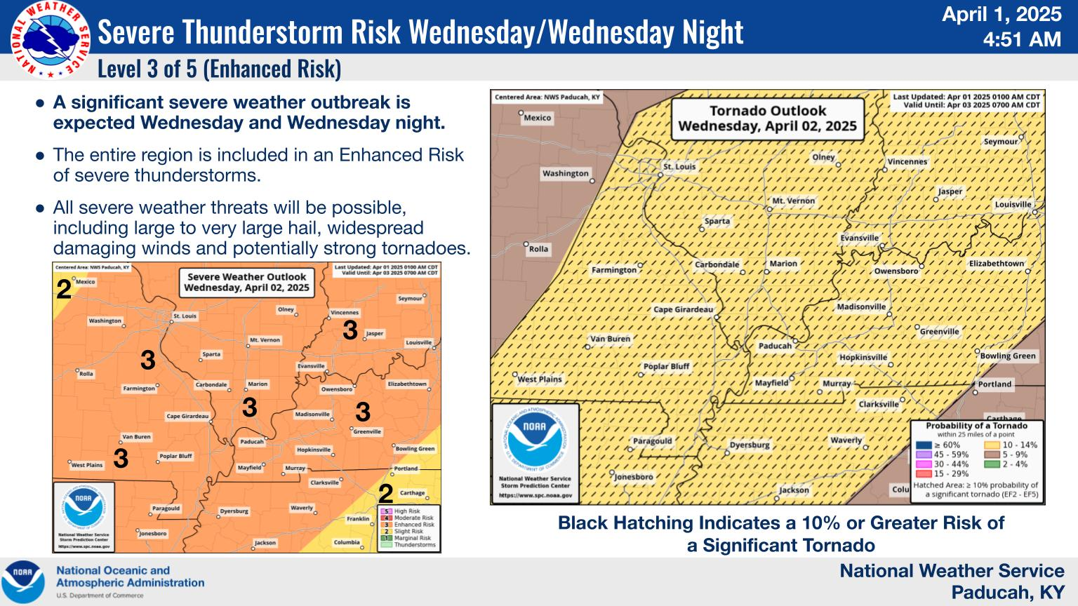
Approximate timing. Adjustments are possible.
.
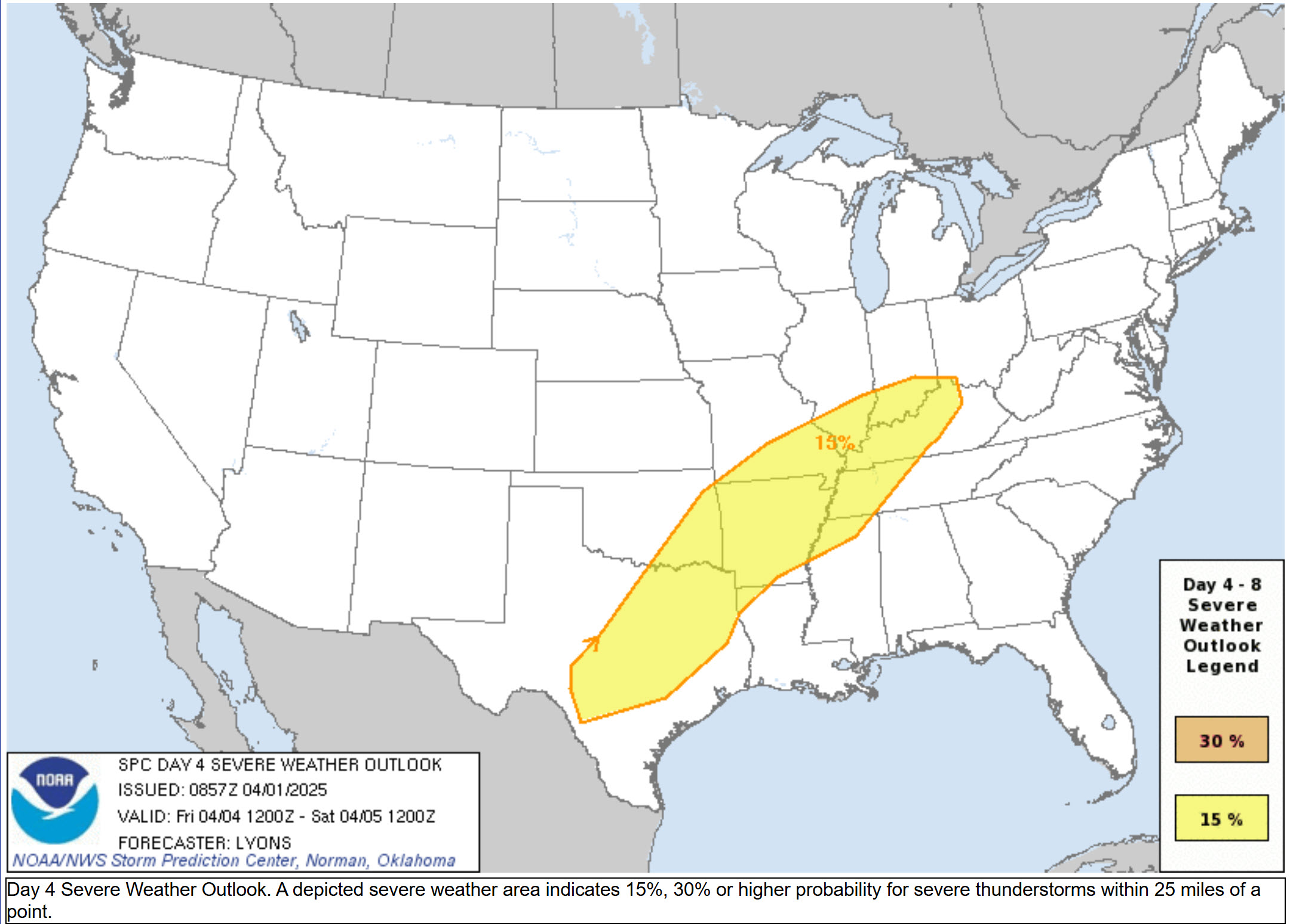
This is the Thursday severe weather risk zone. A level one and two risk. Adjustments in the placement are possible. This will be highly dependent on where the front stalls.
.
Here is the Friday severe weather outlook. A level two risk.
.
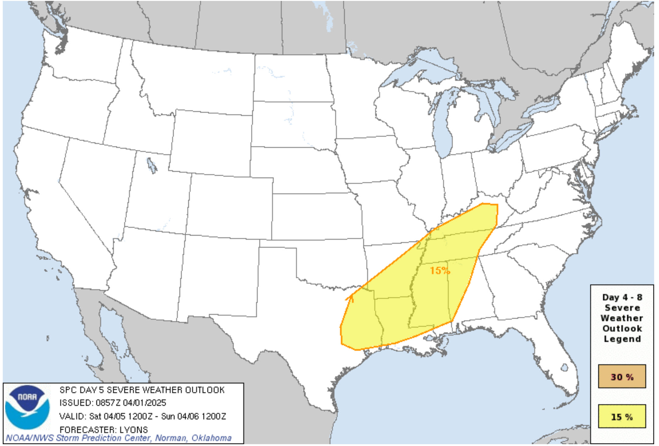
This is the Saturday severe weather outlook. A level two risk.
.
Let’s take it one day at a time. This is a prolonged weather event.
.

Seven-Day Hazardous Weather Outlook
1. Is lightning in the forecast? YES. Lightning is possible tonight into Saturday night. I will monitor Sunday.
2. Are severe thunderstorms in the forecast? YES. There is a risk of severe on Wednesday. Mainly the afternoon and overnight hours.
Another risk Thursday into Saturday. The Thursday into Saturday risk will depend on where the front stalls. Monitor updates.
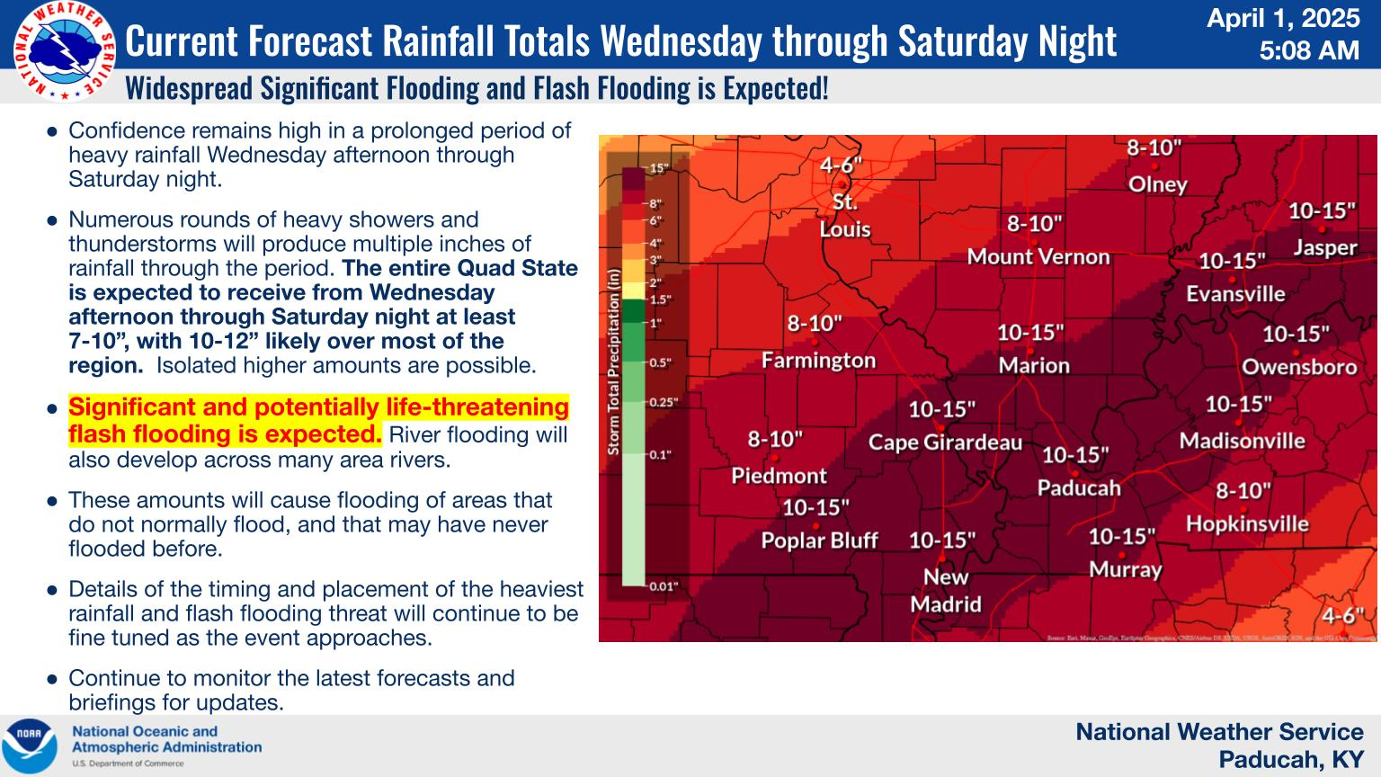
3. Is flash flooding in the forecast? YES. Significant flash flooding is expected. Significant river flooding is likely. Flash flooding is likely Wednesday into Saturday. Locally, very heavy rain is anticipated. Some counties could exceed eight inches of rain. Monitor updates.
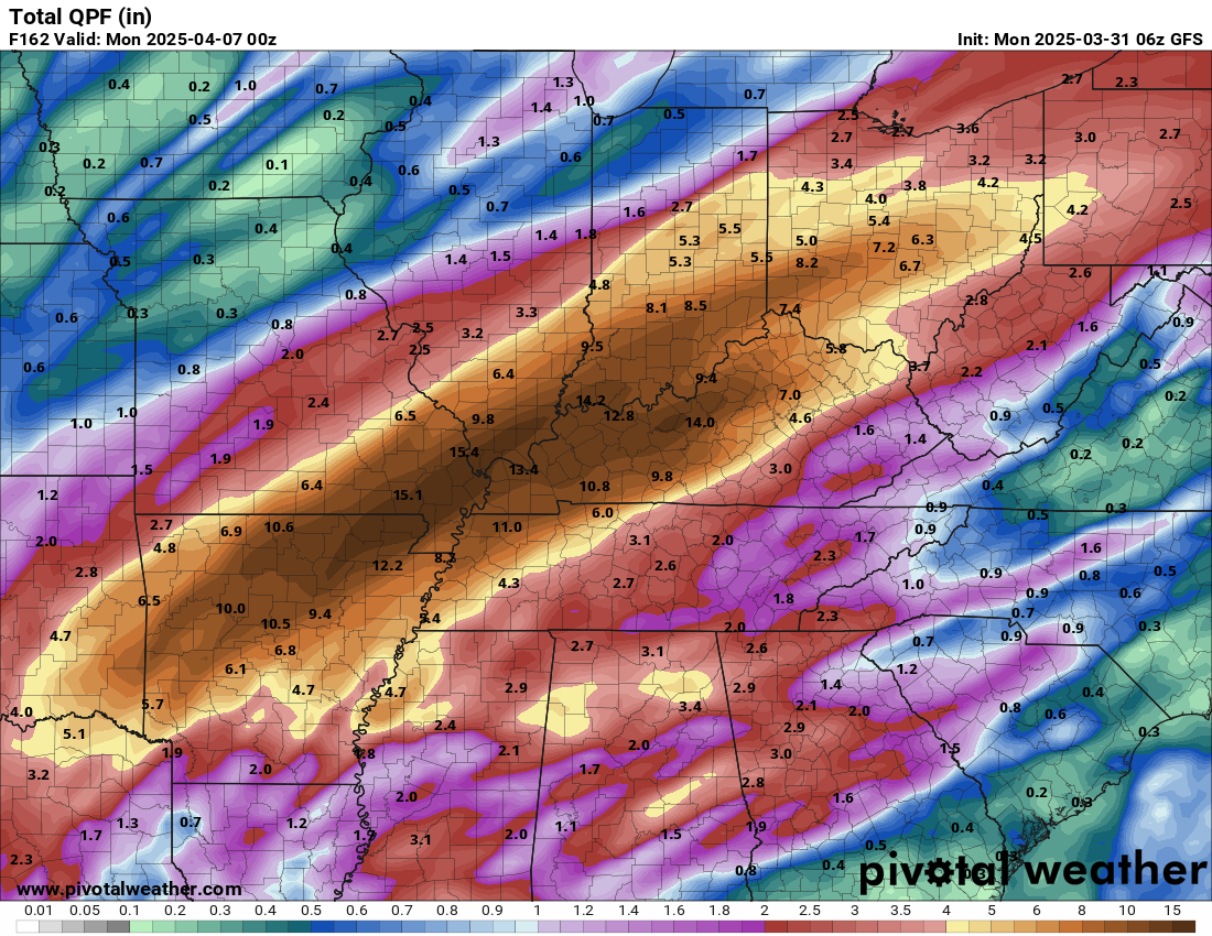
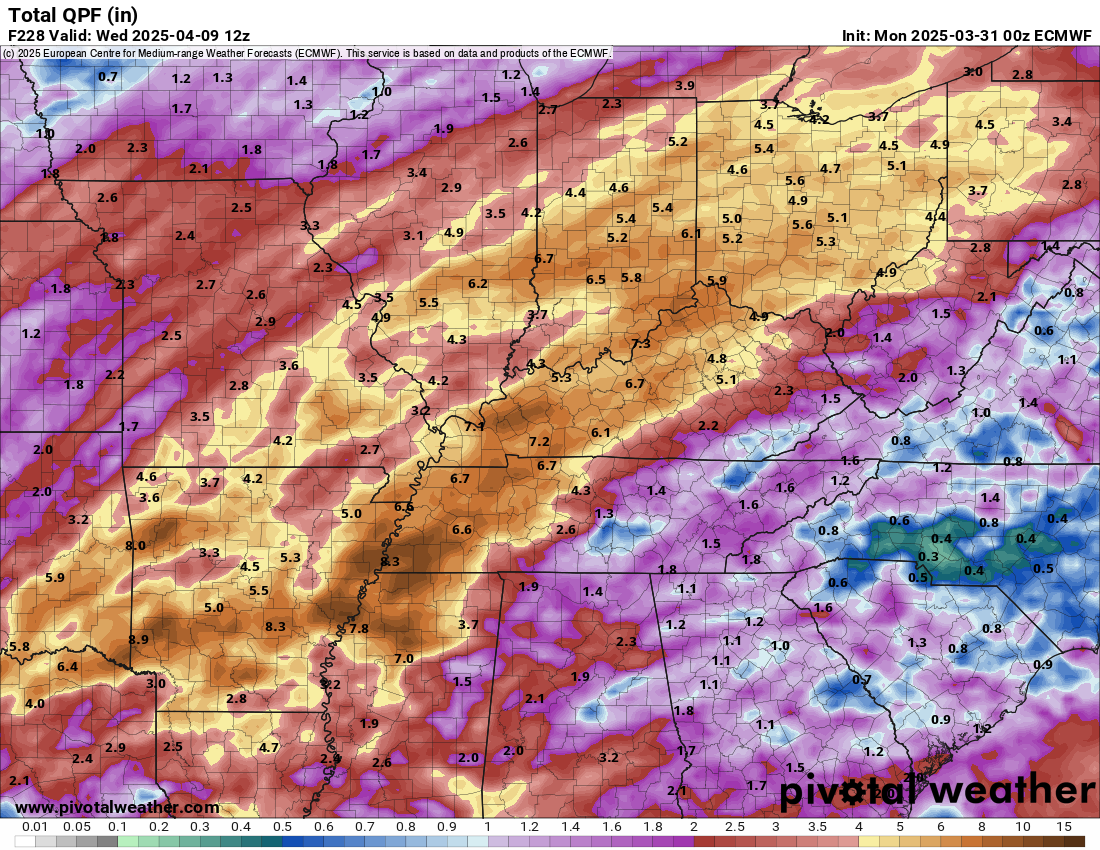
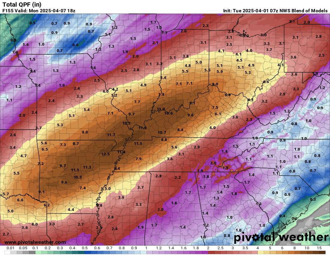
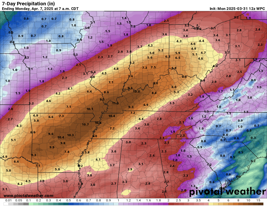
I am expecting a widespread 5 to 10 inches of rain. Then, pockets of higher than ten inches will be possible.
This graphic is from the NWS.
Totals will vary, of course. These are extreme numbers.
We will have to see if the 10 to 15-inch band develops. I expect a widespread 5 to 10 inches and then pockets higher than 1o inches.
.
4. Will non-thunderstorm winds top 40 mph? YES. Gusty winds are likely on Wednesday. Gusts above 40 mph are anticipated. These will be gradient winds. General winds.
5. Will temperatures rise above 90 degrees? NO.
6. Will the heat index rise above 100 degrees? NO.
.
A quick forecast glance. Your 48-hour forecast Graphics


.

.

.
Severe weather outlook. Flood outlook.

Forecast discussion.
- An active week of weather ahead. Monitor updates.
- Gusty winds on Wednesday. General winds will range from 20 to 45 mph.
- I am monitoring late tonight for a low-end risk of severe weather over southeast Missouri and southwest Illinois.
- A severe weather event will likely develop on Wednesday. The focus will be on the afternoon and overnight hours. Monitor updated forecasts for details and timing.
- The guidance indicates the severe threat could continue into Thursday and Friday. I will monitor Saturday.
- A significant flood and flash flood risk will develop Wednesday into Sunday.
- Locally, very heavy rain is anticipated Wednesday into Saturday. Pockets of five to eight+ inches appear likely. We will need to fine-tune the placement of the heavier rain bands.
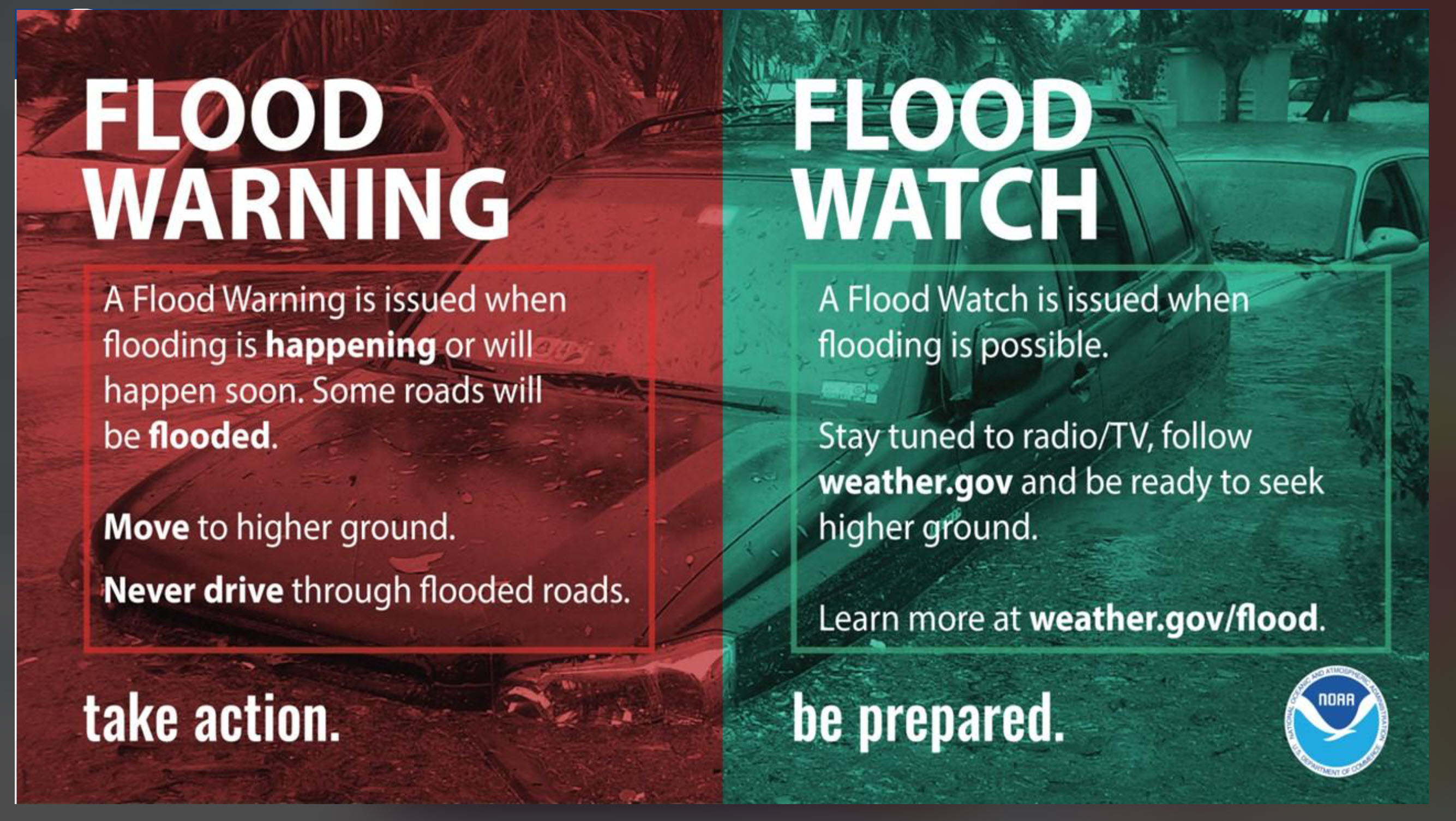
- Monitor watches and warnings. A watch means to pay attention. A WARNING means to seek shelter or take action.
.

.
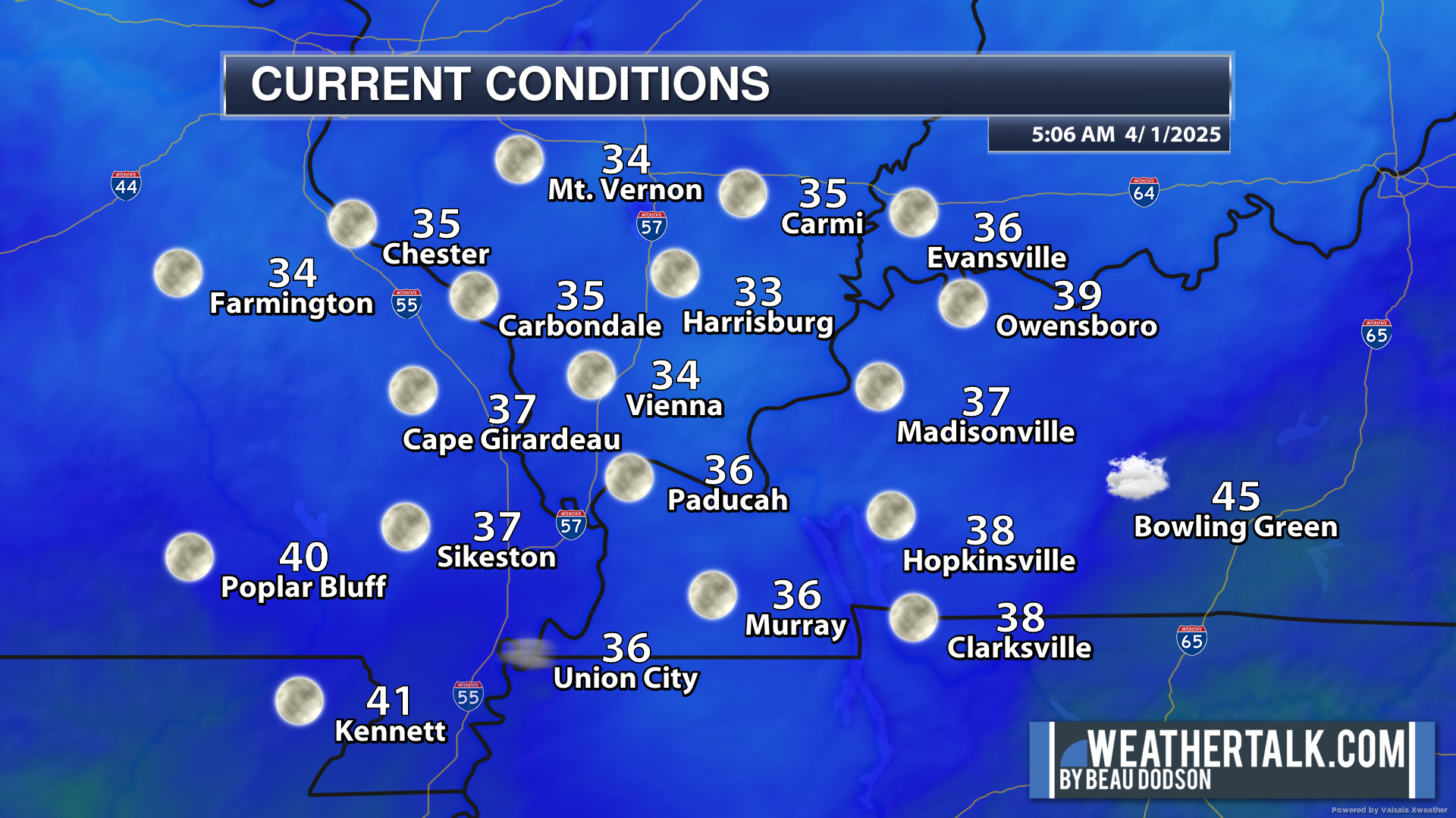
We are waking up to chilly temperatures. Even some patchy frost.
5 AM temperatures.
.
Today will be the quiet before the storm. Most of tonight, as well. Some broken sunshine today. Warmer.
A few showers and storms will develop late tonight. Probabilities are fairly low but not zero. I can’t rule out small hail with any storms that do manage to form. The chance of storms will peak over southeast Missouri and southern Illinois (around 20%).
Overall, tonight will be dry.
A very active weather pattern will develop tomorrow into the weekend.
You will have already heard about the potential for severe weather and flash flooding. Nothing has changed over the past 24 hours.
I am concerned about significant flooding in some areas. A widespread 5 to 10 inches of rain is anticipated across the bulk of our region.
Rain totals could exceed 10 inches. This is an extreme rainfall event.
Flash flooding is likely. Life-threatening flooding is possible.
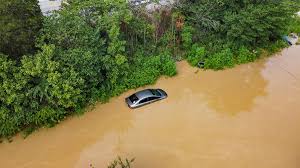
Avoid flooded roadways.
Don’t do this. You put yourself and others at risk.
Why are we experiencing all of this rain?
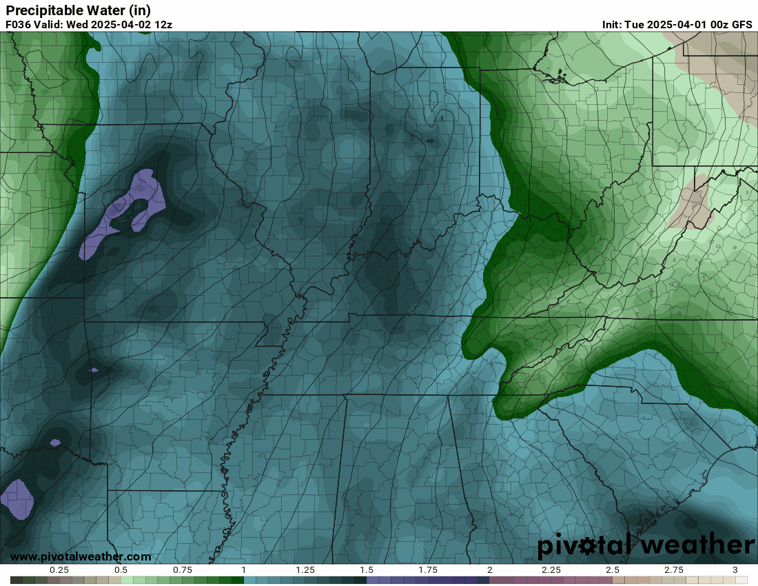
The climatology maps show records amount of Gulf moisture. PWAT values will peg out for this time of the year. PWAT is a measure of moisture.
Here are the PWAT values. Again, PWAT measures moisture in the atmosphere.
The purple zone are extreme moisture numbers. Notice how they stall over our region.
Double-click animations to enlarge them.
.
This is because the Gulf waters are so warm. That warmth represents energy.
Here is the Gulf of Mexico anomaly map.
The red line is the current temperature anomaly. Very warm waters.
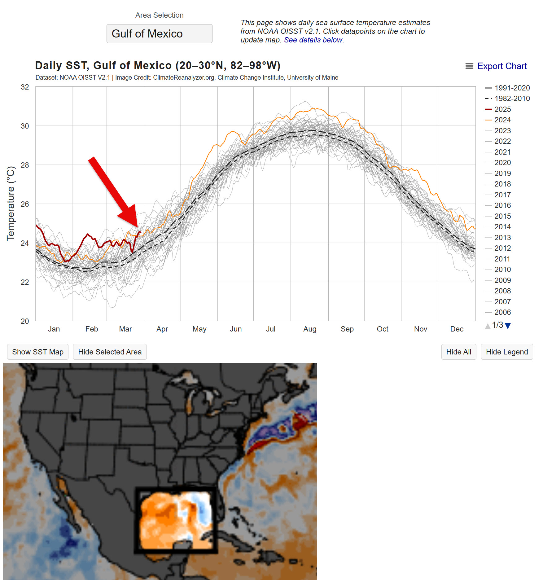
.
All of that energy must go somewhere. This is why we are experiencing severe weather and heavy rain.
Check out the GFS model. Rainfall totals. These are just crazy numbers for a model.
The EC model is extreme but not as extreme as the GFS.
.
Here is the blend of models. You can see the theme. Big numbers.
.
Here is the WPC NOAA forecast, which has big rain totals.
.
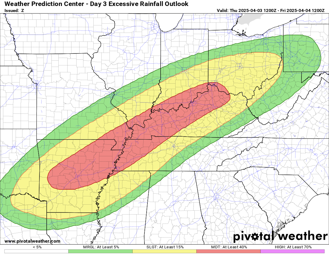
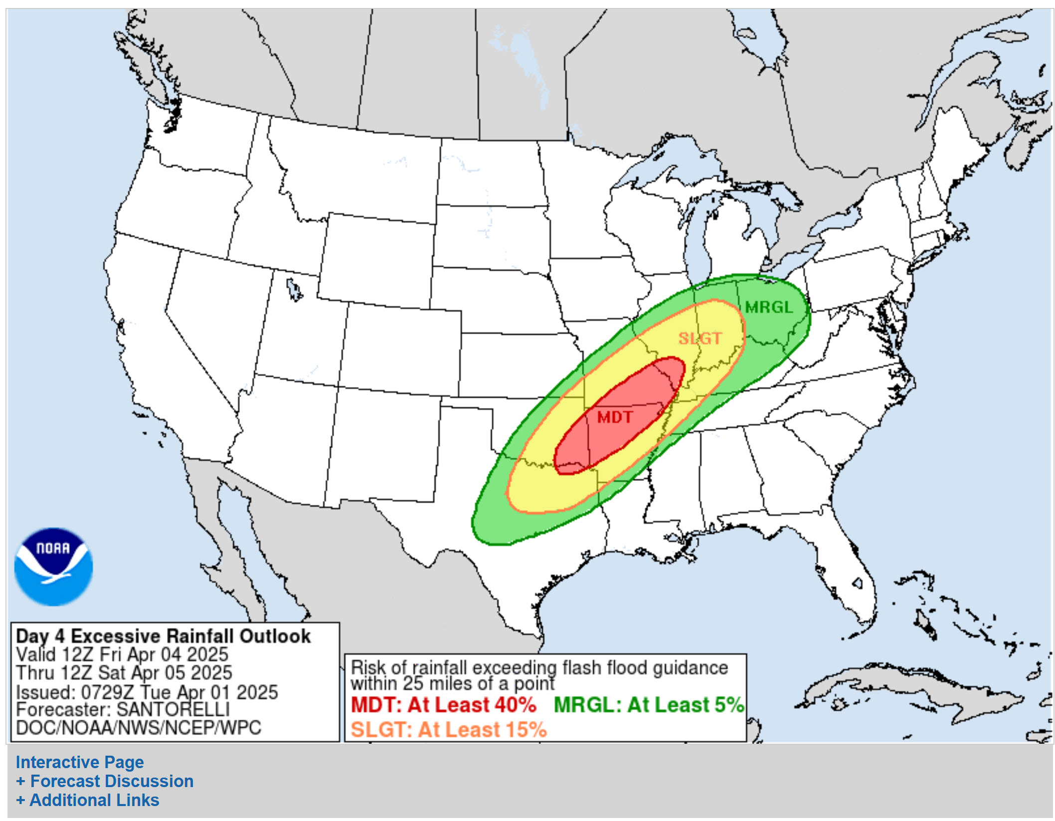
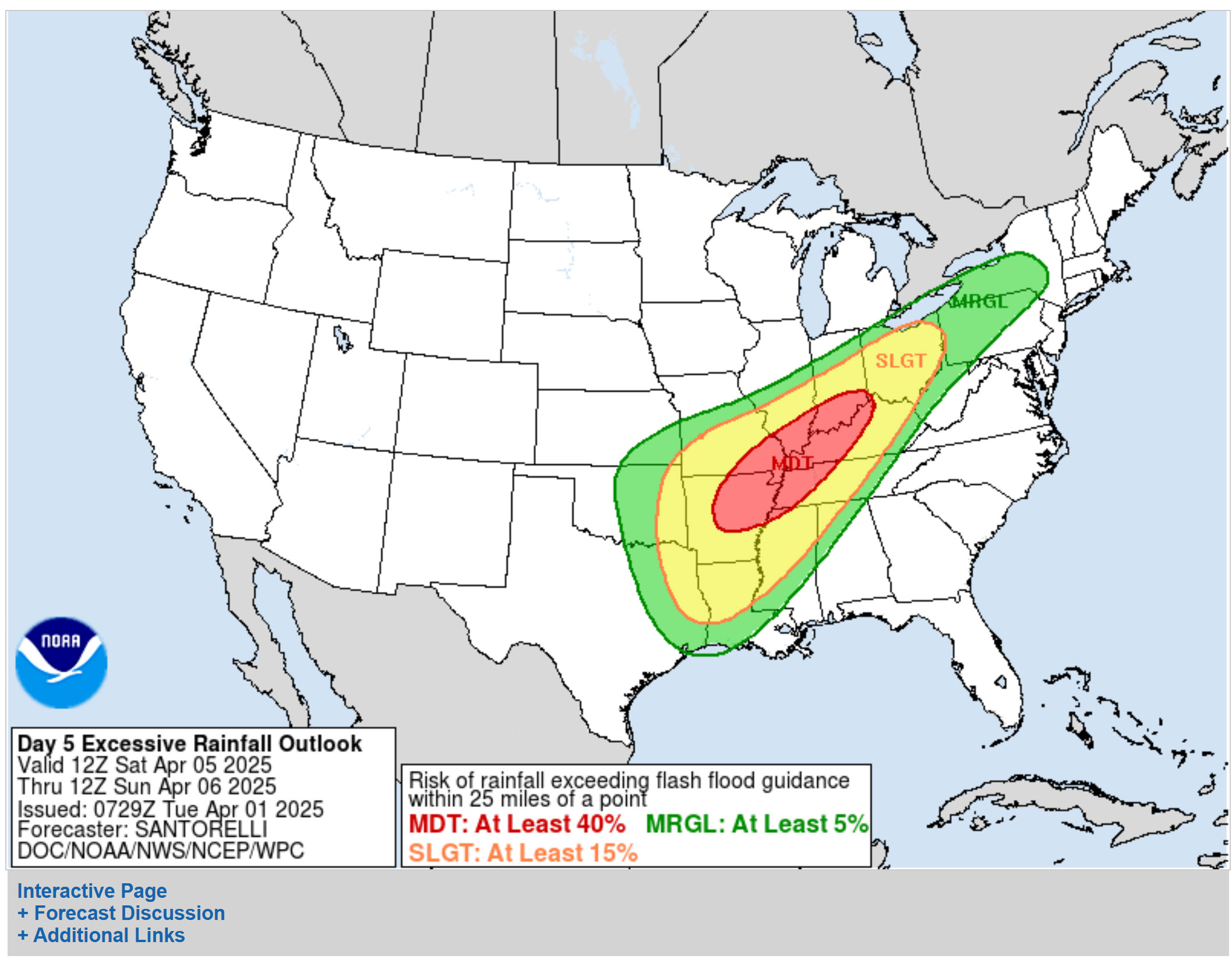
Here is the flood risk outlook from the WPC/NOAA
Wednesday flash flood outlook. We are at a moderate risk.
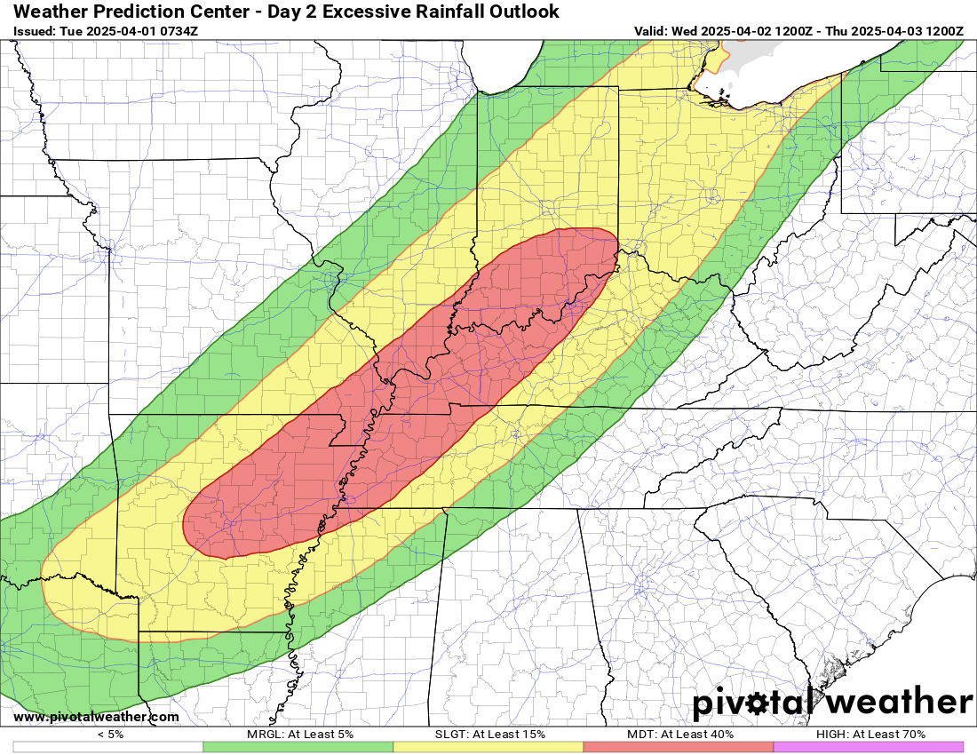
Thursday outlook. Another moderate risk.
Friday flood outlook. Another moderate risk.
Saturday flood outlook. This may be upgraded to a high risk of flooding.
.
Here are some comments from the WPC/NOAA
Strong language from them.
WPC The previous MDT risk inherited from the D4 was relatively maintained, however there was some expansion of the MDT to the northwest to account for a small trend within the forecasted alignment of the quasi-stationary front and amplitude of expected surface wave ejecting out of the southern plains. This period is considered to be a higher-end Moderate, meaning the prospects for a targeted high risk are within reason pending the previous period’s QPF outcome and the convective expectation as we get closer to the D3 time frame. The area of vested interest for a potential upgrade includes that corridor of northeast Arkansas up through western Tennessee, far southeast Missouri, western Kentucky, and slivers of both southern Illinois and Indiana. This setup is shaping up to be a more extreme flooding scenario considering the multi-day prospects and forecasted 72 to 96 hr rainfall totals reaching 10-15+ inches in the hardest hit locations. Be sure to prepare if you live in a flood zone anywhere from Arkansas, northeast through the Ohio/Tennessee Valley’s. Anyone surrounding will want to monitor this setup closely as small changes could have heightened impacts given the forecasted setup.
As mentioned above, in addition to heavy rain, severe weather will be a concern.
.
Discussion
As mentioned above, a few storms may occur late tonight. The concern will be lightning and small hail. I suspect the bulk of the region remains dry tonight.
A higher severe weather risk will develop on Wednesday and Wednesday night. A high-end severe weather event is possible. That means baseball-sized hail, damaging wind, and tornadoes.
Stay weather-aware. Make sure you have multiple ways of receiving your severe weather information.
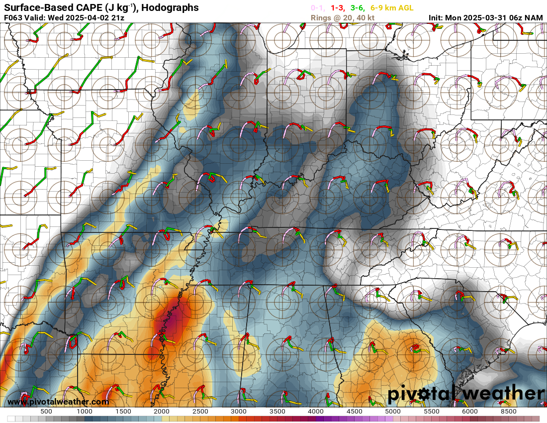
The hodographs are very large for this system.
A hodograph shows us the state of the atmosphere. Those little pink curly lines represent a lot of rotation in the atmosphere.
They are long stretched hodo’s. That is a signal for tornadoes. Some strong and long-tracked. This will need to be closely monitored.
This is for Wednesday and Wednesday night.
.
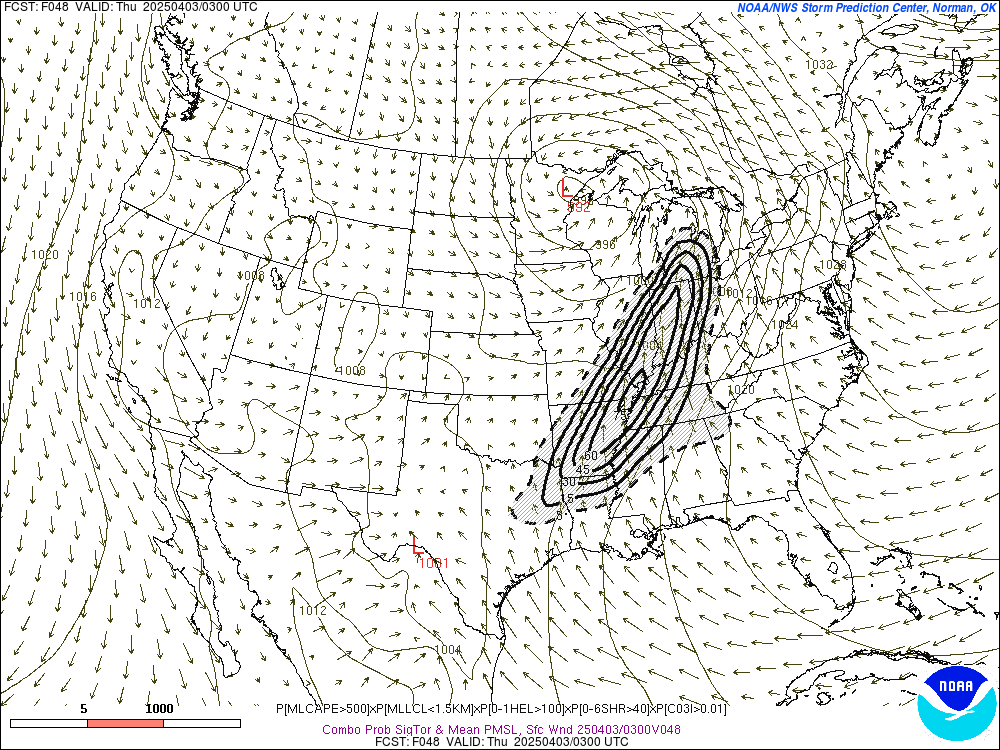
Here are the Significant Tornado Parameter numbers for tomorrow. You can see the colors pop over our region. That means there will be spin in the atmosphere.

.
The SREF tornado ingredients max out over our region on Wednesday afternoon and evening.
Monitor watches and warnings over the coming days.
.
Monitor updates.
Again, as mentioned above, severe storms are possible on Thursday and Friday, as well.
Needless to say, this is a lot of weather to cover.
Please stay abreast of the latest weather information.
Let’s not become storm wary. Stay weather-aware over the coming days.
.

The timestamp (upper left) is in Zulu. 12z=6 am. 18z=12 pm. 00z=6 pm.
Double-click the animation to enlarge it.
Double-click the animation to enlarge it.
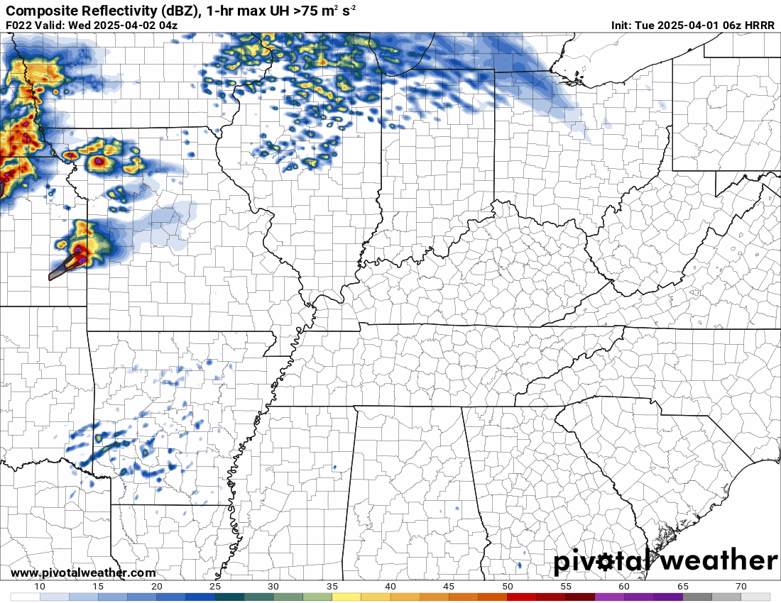
This is the Hrrr model for Wednedsay.
.
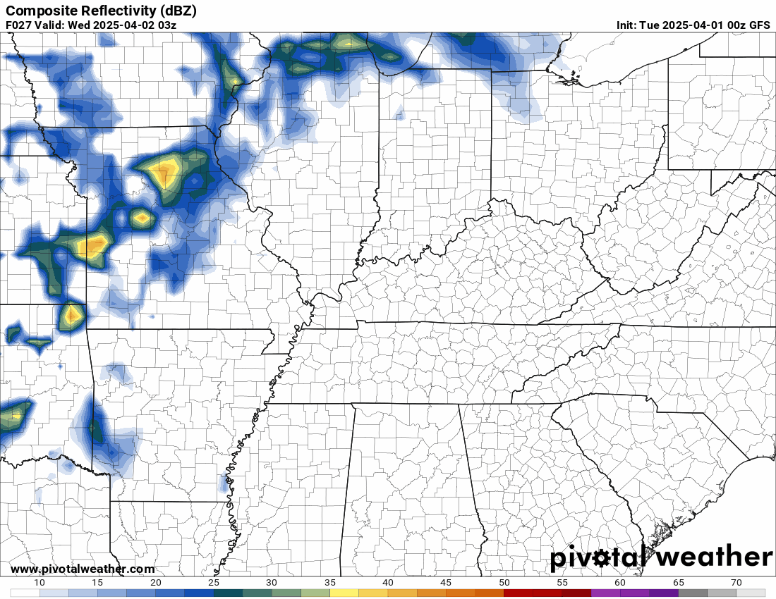
This is the GFS model from Tuesday into Saturday. Round after round of rain. Some heavy.
.

.
Click here if you would like to return to the top of the page.
.Average high temperatures for this time of the year are around 62 degrees.
Average low temperatures for this time of the year are around 40 degrees.
Average precipitation during this time period ranges from 0.90″ to 1.20″
Six to Ten Day Outlook.
Blue is below average. Red is above average. The no color zone represents equal chances.
Average highs for this time of the year are in the lower 60s. Average lows for this time of the year are in the lower 40s.

Green is above average precipitation. Yellow and brown favors below average precipitation. Average precipitation for this time of the year is around one inch per week.

.

Average low temperatures for this time of the year are around 42 degrees.
Average precipitation during this time period ranges from 0.90″ to 1.20″
.
Eight to Fourteen Day Outlook.
Blue is below average. Red is above average. The no color zone represents equal chances.

Green is above average precipitation. Yellow and brown favors below average precipitation. Average precipitation for this time of the year is around one inch per week.

.
.
.
We have a new service to complement your www.weathertalk.com subscription. This does NOT replace www.weathertalk.com It is simply another tool for you to receive severe weather information.
.
.
Radars and Lightning Data
Interactive-city-view radars. Clickable watches and warnings.
https://wtalk.co/B3XHASFZ
Old legacy radar site (some of you like it better)
https://weatherobservatory.com/weather-radar.htm
If the radar is not updating then try another one. If a radar does not appear to be refreshing then hit Ctrl F5. You may also try restarting your browser.
Backup radar site in case the above one is not working.
https://weathertalk.com/morani
Regional Radar
https://imagery.weathertalk.com/prx/RadarLoop.mp4
** NEW ** Zoom radar with chaser tracking abilities!
ZoomRadar
If the radar is not working, then email me: Email me at beaudodson@usawx.com
.
We do have some sponsors! Check them out.
Roof damage from recent storms? Link – Click here
INTEGRITY ROOFING AND EXTERIORS!
⛈️ Roof or gutter damage from recent storms? Today’s weather is sponsored by Integrity Roofing. Check out their website at this link https://www.ourintegritymatters.com/

![]()
![]()
![]()
Make sure you have three to five ways of receiving your severe weather information.
Weather Talk is one of those ways! Now, I have another product for you and your family.

.
Want to add more products to your Beau Dodson Weather App?
Receive daily videos, weather blog updates on normal weather days and severe weather and winter storm days, your county by county weather forecast, and more!
Here is how to do add those additional products to your app notification settings!
Here is a video on how to update your Beau Dodson Weather payment.
The app is for subscribers. Subscribe at www.weathertalk.com/welcome then go to your app store and search for WeatherTalk
Subscribers, PLEASE USE THE APP. ATT and Verizon are not reliable during severe weather. They are delaying text messages.
The app is under WeatherTalk in the app store.

Apple users click here

Android users click here
.
Radars and Lightning Data
Interactive-city-view radars. Clickable watches and warnings.
https://wtalk.co/B3XHASFZ
Old legacy radar site (some of you like it better)
https://weatherobservatory.com/weather-radar.htm
If the radar is not updating then try another one. If a radar does not appear to be refreshing then hit Ctrl F5. You may also try restarting your browser.
Backup radar site in case the above one is not working.
https://weathertalk.com/morani
Regional Radar
https://imagery.weathertalk.com/prx/RadarLoop.mp4
** NEW ** Zoom radar with chaser tracking abilities!
ZoomRadar
Lightning Data (zoom in and out of your local area)
https://wtalk.co/WJ3SN5UZ
Not working? Email me at beaudodson@usawx.com
National map of weather watches and warnings. Click here.
Storm Prediction Center. Click here.
Weather Prediction Center. Click here.
.

Live lightning data: Click here.
Real time lightning data (another one) https://map.blitzortung.org/#5.02/37.95/-86.99
Our new Zoom radar with storm chases
.
.

Interactive GOES R satellite. Track clouds. Click here.
GOES 16 slider tool. Click here.
College of DuPage satellites. Click here
.

Here are the latest local river stage forecast numbers Click Here.
Here are the latest lake stage forecast numbers for Kentucky Lake and Lake Barkley Click Here.
.
.
Find Beau on Facebook! Click the banner.


 .
.