
.

.
I have some question-and-answer threads over on the Facebook page. Link to those threads CLICK HERE
Or email me at beaudodsonweather@gmail.com
.

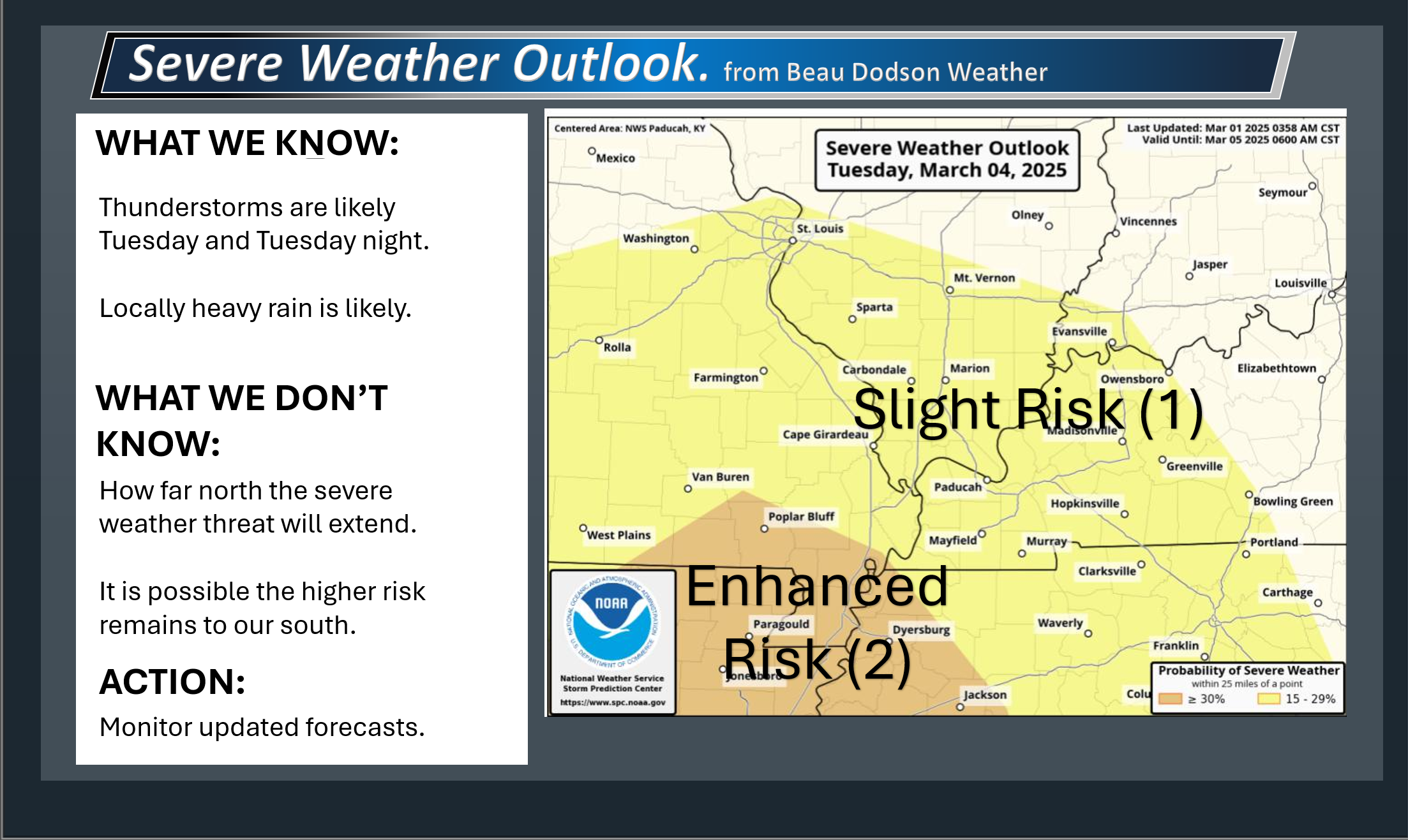
Seven-Day Tornado Outlook
March 1st through March 7th
RISK LEVEL: MONITOR
Confidence: Low.
Comment: I am closely monitoring Tuesday afternoon and evening. There may not be high enough dew points to raise tornado concerns. Most data shows that richer/higher moisture levels and instability remain to our south. That said, wind fields will be very strong (wind shear). If dew points were a bit higher, then I would be more concerned.
Confidence in the tornado threat remains low. I will know more tomorrow.
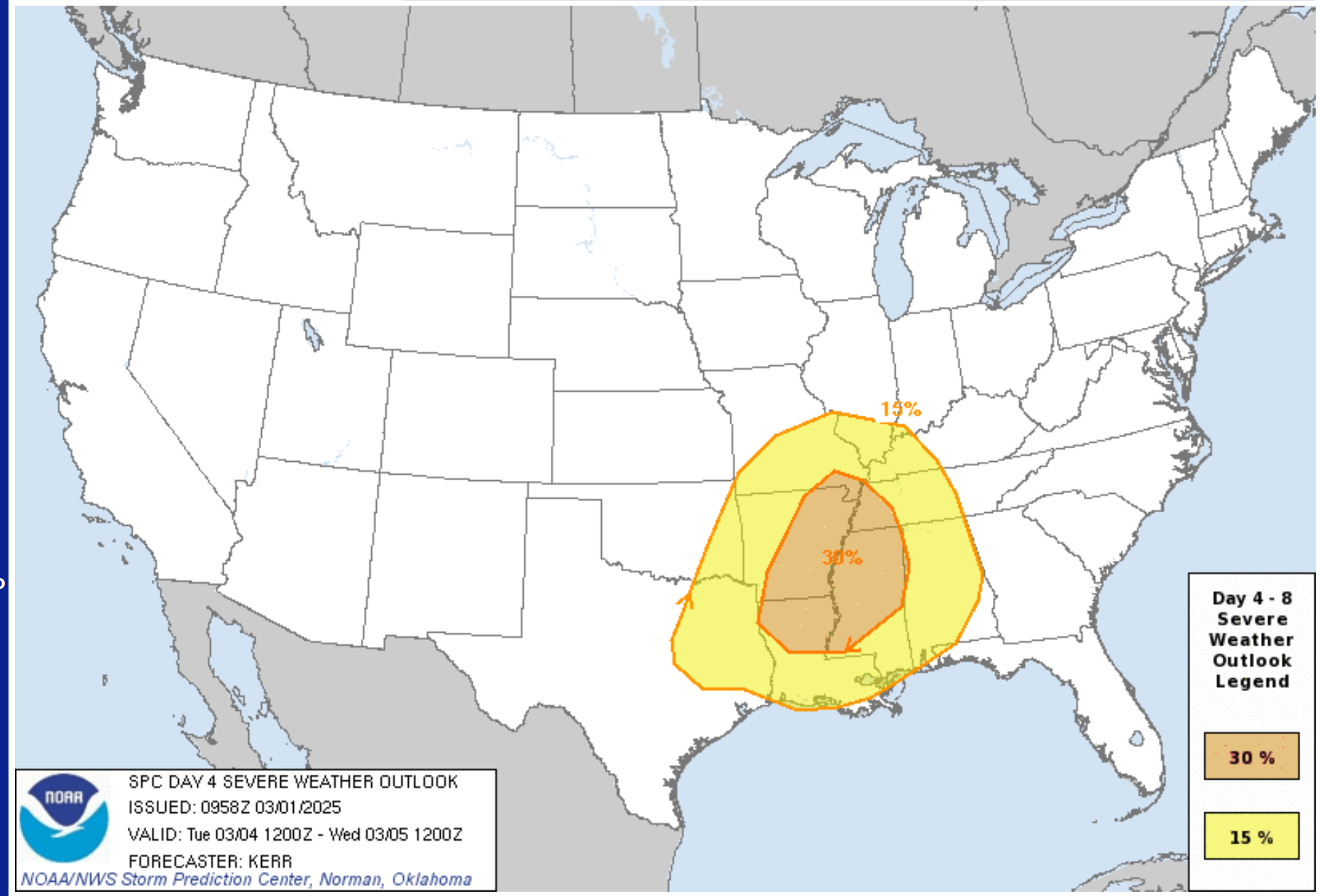
Here is a National Weather Service/NOAA graphic. Again, there remain questions about the extent of the threat.
.
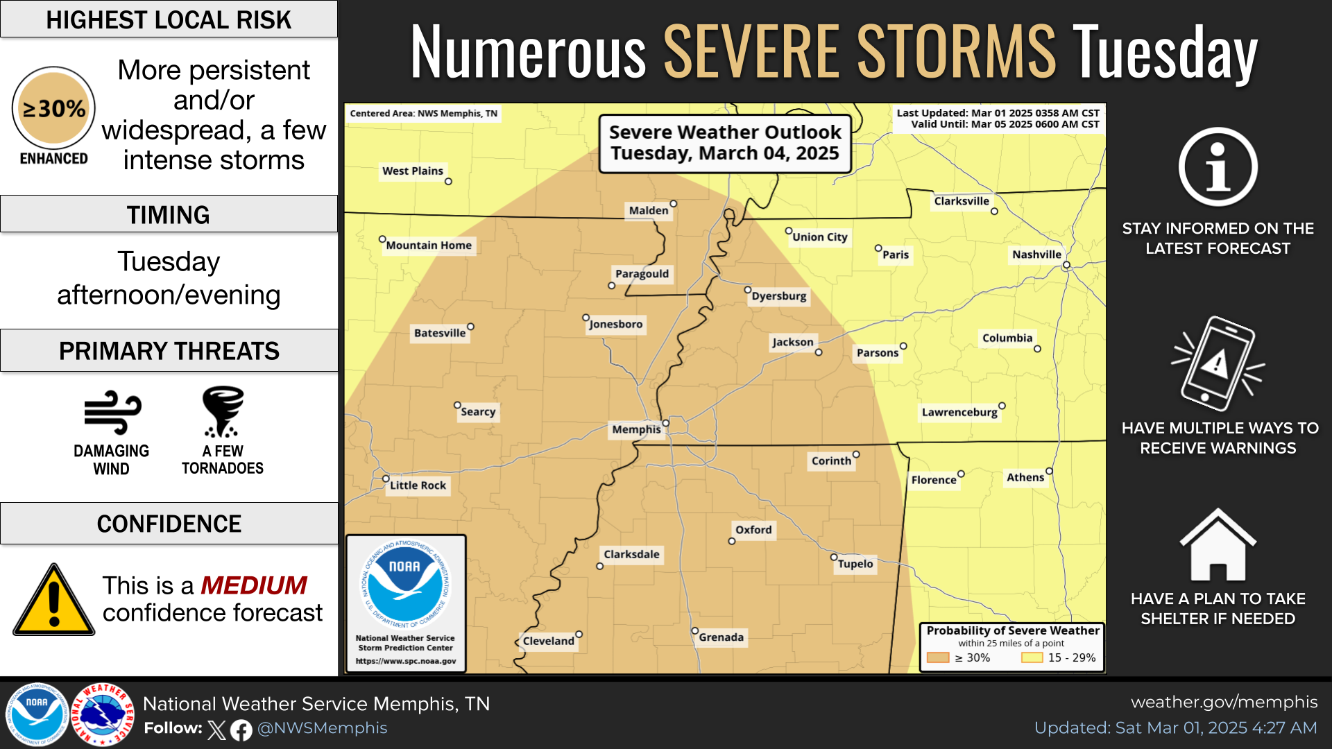
This next graphic is from the Memphis NOAA office
Again, I would caution that the northern portion of this graphic is questionable (the Bootheel and northwest Tennessee). SPC already trimmed it back some. More adjustments are likely.
.
.
Seven-Day Hazardous Weather Outlook
1. Is lightning in the forecast? YES. Lightning is possible Monday night into Tuesday night. Mostly on Tuesday and Tuesday night.
2. Are severe thunderstorms in the forecast? POSSIBLE. There is a threat of severe weather on Tuesday. Mainly Tuesday afternoon and evening.
3. Is flash flooding in the forecast? POSSIBLE. Locally heavy rain is possible on Tuesday. This could lead to some drainage issues. Field flooding, ditches flooding, sharp rises on streams. Commonly flooded roadways could have issues. Widespread flash flooding is unlikely. Local issues are possible.
4. Will non-thunderstorm winds top 40 mph? LOW RISK. Gusty winds are possible on Tuesday/Tuesday night.
5. Will temperatures drop below 10 degrees? NO.
6. Will the wind chill dip below 0 degrees? NO.
7. Is measurable snow and/or sleet in the forecast? NO.
8. Is freezing rain/ice in the forecast? NO.
.
A quick forecast glance. Your 48-hour forecast Graphics


.

.


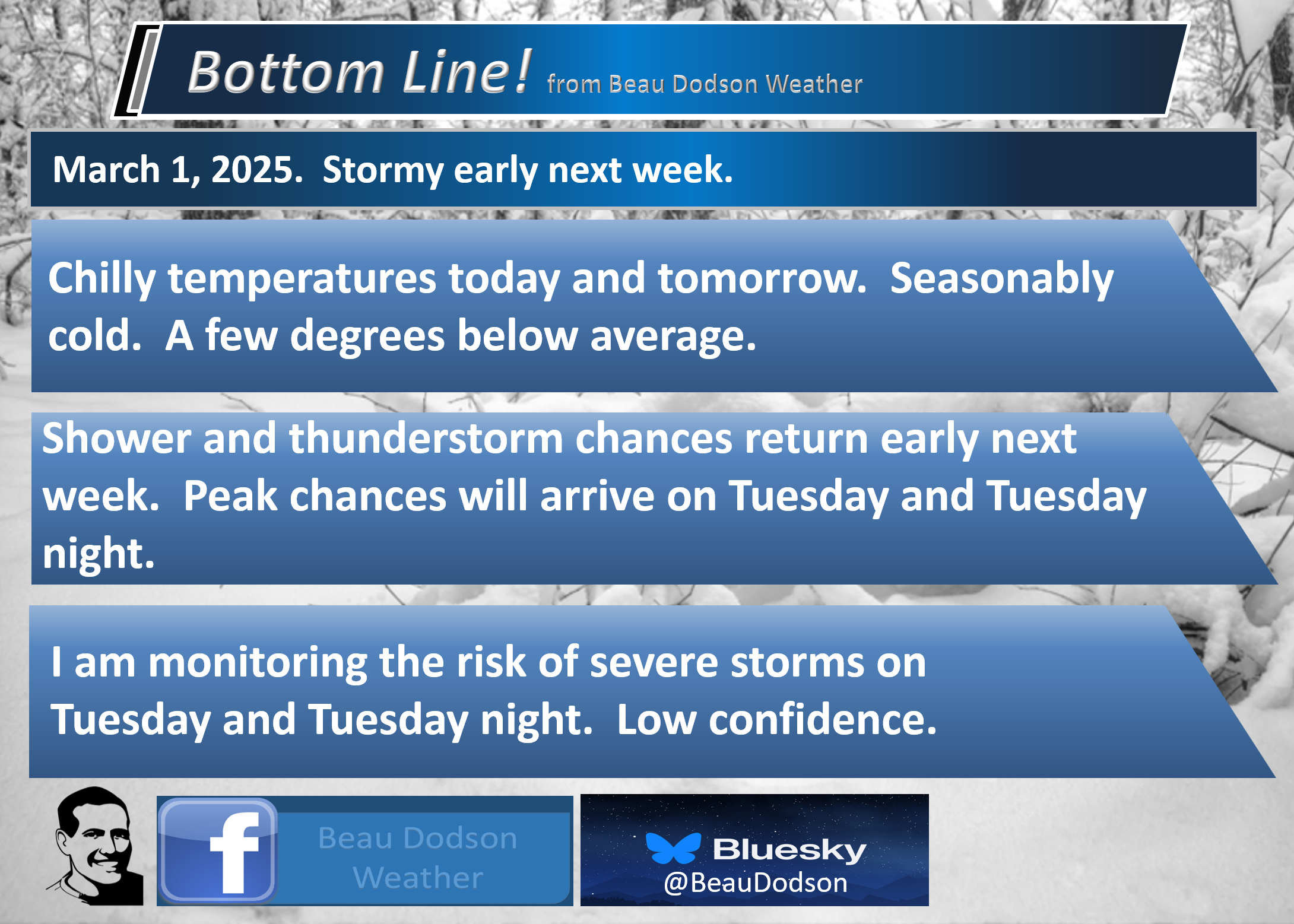
Forecast discussion.
- Chilly today and tomorrow. Dry.
- Warmer air returns by Monday and Tuesday.
- A few showers are possible on Monday and Monday night.
- Showers and thunderstorms are likely on Tuesday and Tuesday night. Locally heavy downpours are likely. Severe thunderstorms are possible (but confidence in the severe weather risk remains low).
.

.
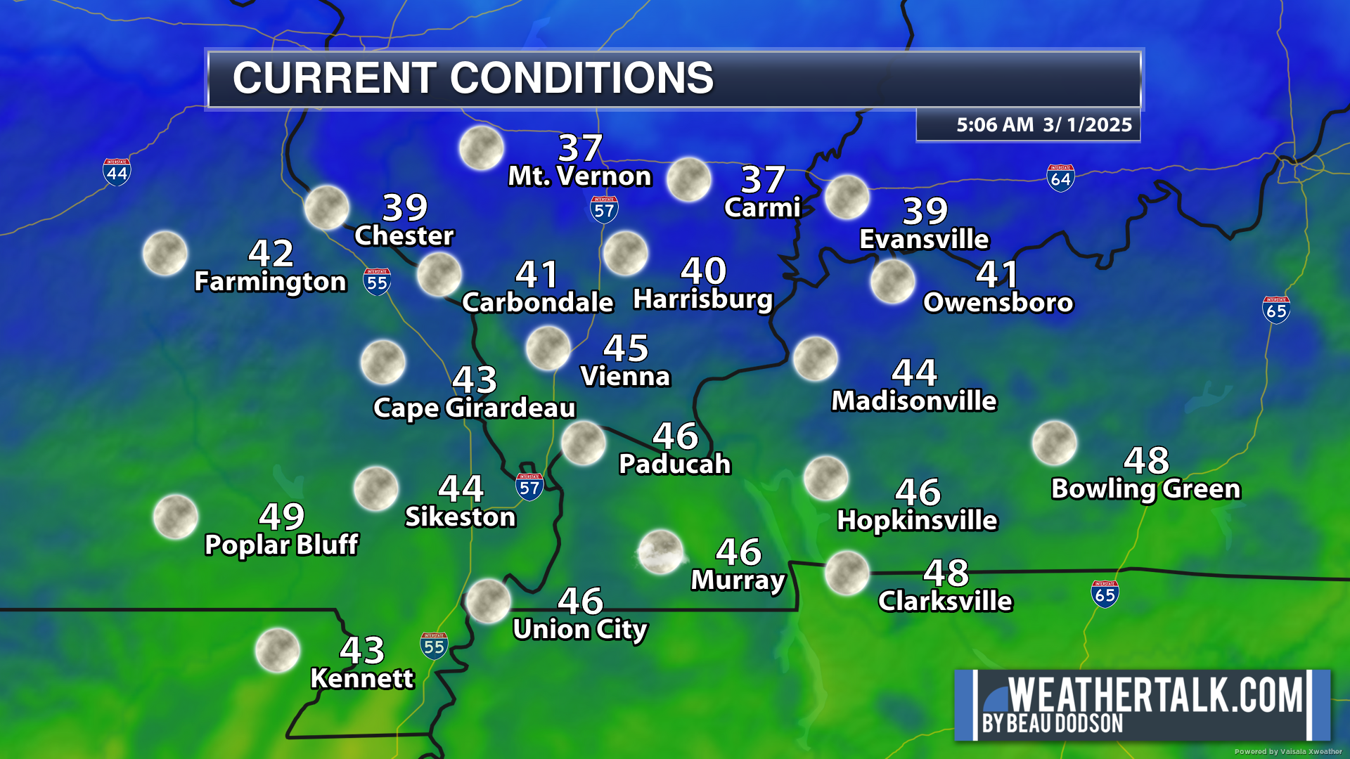
We are waking up to cool temperatures. Nothing extreme.
.
.
Today will be chilly. Tonight and tomorrow, as well. This round of chilly temperatures will be short-lived.
Temperatures will begin to warm by Monday and Tuesday.
Dry conditions today and tomorrow.
A larger storm system will push into our region on Monday and Tuesday.
A few showers are possible on Monday and Monday night as a weak system moves across the region.
The stronger system will arrive on Tuesday and Tuesday night.
Data continues to speed the front up. It now looks as if it will reach southeast Missouri by the late morning or early afternoon hours. Then, it will push eastward through the afternoon and evening hours.
A band of showers and thunderstorms will accompany the front.
Locally heavy rain and lightning are likely with this band.
I continue to monitor the threat of severe weather, but confidence remains low.
Several ingredients are lacking for a more significant severe weather event.
Dew points appear to struggle. The dew point is a measure of moisture. Low dew points would inhibit the severe weather threat.
Instability (CAPE) appears limited, as well.
The higher severe weather probabilities may remain to our south.
The Storm Prediction Center/NOAA continues to shift its outlook. That is not unusual. They usually shift it around as the event draws closer.
For now, I continue to monitor the data. I will know more tomorrow. I will send out some app alerts this weekend, as well. Watch for those.
Here is the current severe weather outlook for next Tuesday. A level two and three risk zone.
.
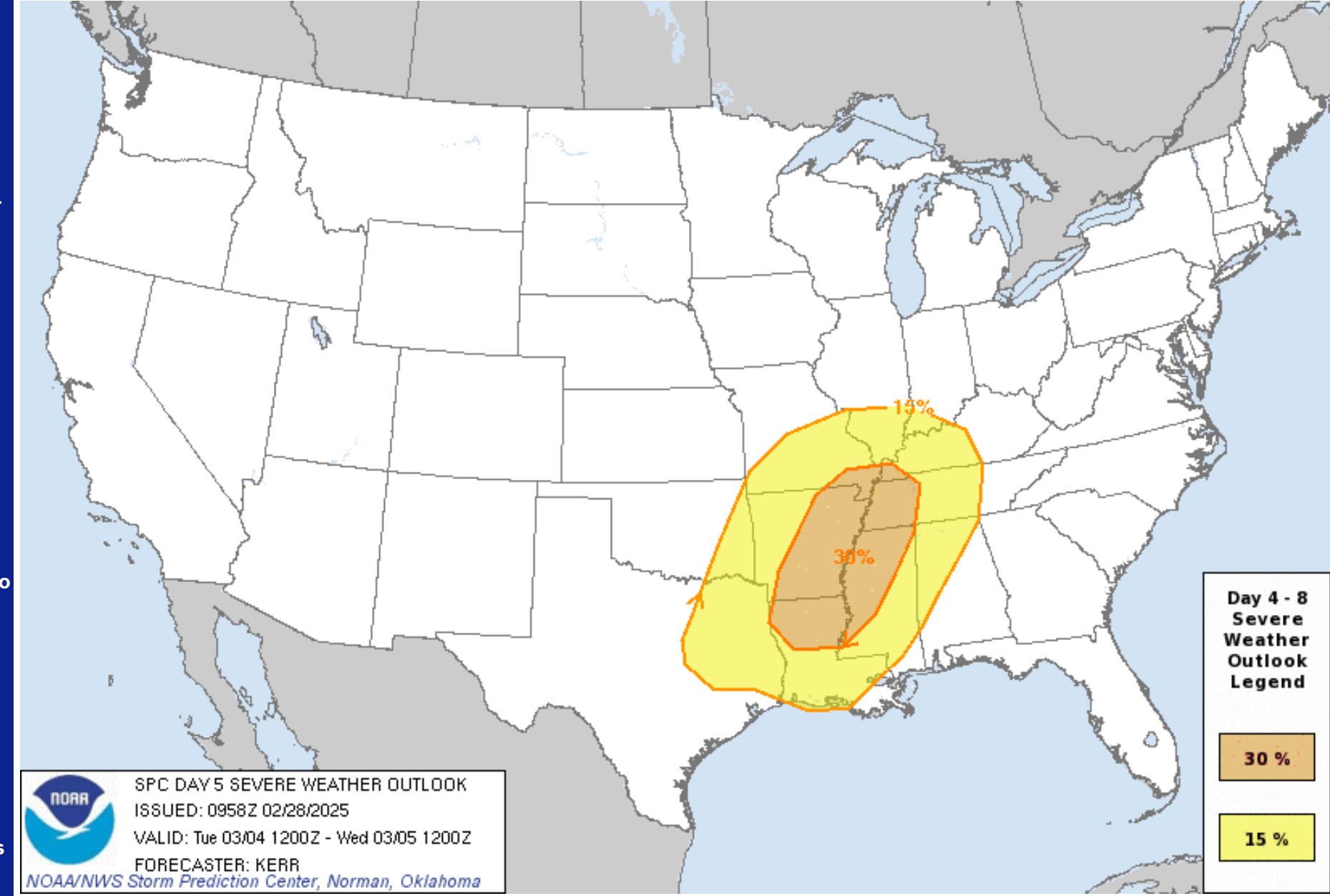
Compare that graphic to yesterday’s outlook. The level three risk has shifted south and west.
This event is still five days out, so there will still be shifts in their outlook.
.
Again, confidence in severe weather is low for our local area.
.
The Memphis, Tennessee, NWS/NOAA posted this update on their page.
They have confidence as medium in their area. They are farther south.
.
There are questions about the dew points/moisture.
There are several ingredients you need for severe thunderstorms and tornadoes.
- Lift (cold front/warm front).
- Instability (unstable air mass)
- Wind shear. An increase in wind speed with height. A turning of wind direction with height.
- Moisture. Higher dew points.
For severe weather, I usually watch for 58 or above in the dew point department.
For a more significant severe weather outbreak, I usually look for a wider warm sector. This does raise some questions about the extent of the risk in our local area. I will be monitoring trends.
If these numbers begin to increase, then the threat will increase. We are still a few days out.
That blue color represents higher dew points. Notice that they stay to our south in the current data. Again, this raises questions about the severe threat locally. I believe the threat to our south will be higher.
GFS model. Dew point forecast for Tuesday afternoon.

.

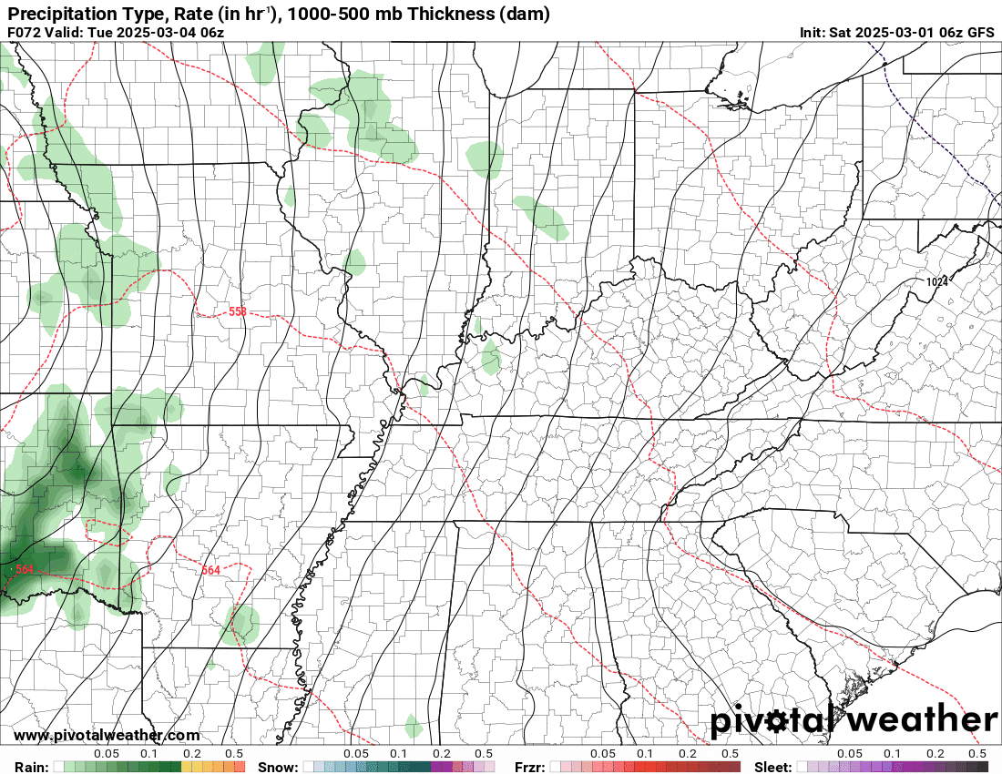
This is what radar might look like Monday into Wednesday
Here is the GFS future-cast radar.
Double-click the animation to enlarge it.
The timestamp (upper left) is in Zulu. 12z=6 am. 18z=12 pm. 00z=6 pm.
You can see the line of showers and thunderstorms racing across our region on Tuesday.
.
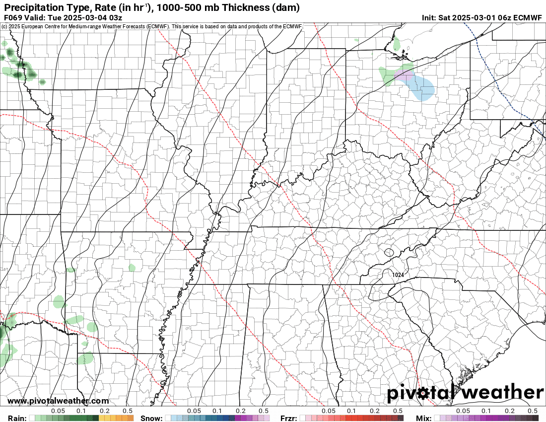
The EC model.
A similar look.
You can see the line of showers and thunderstorms racing across our region on Tuesday.
.
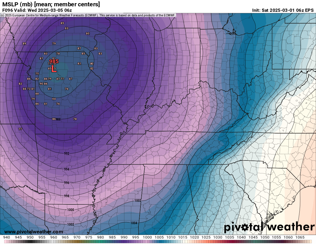
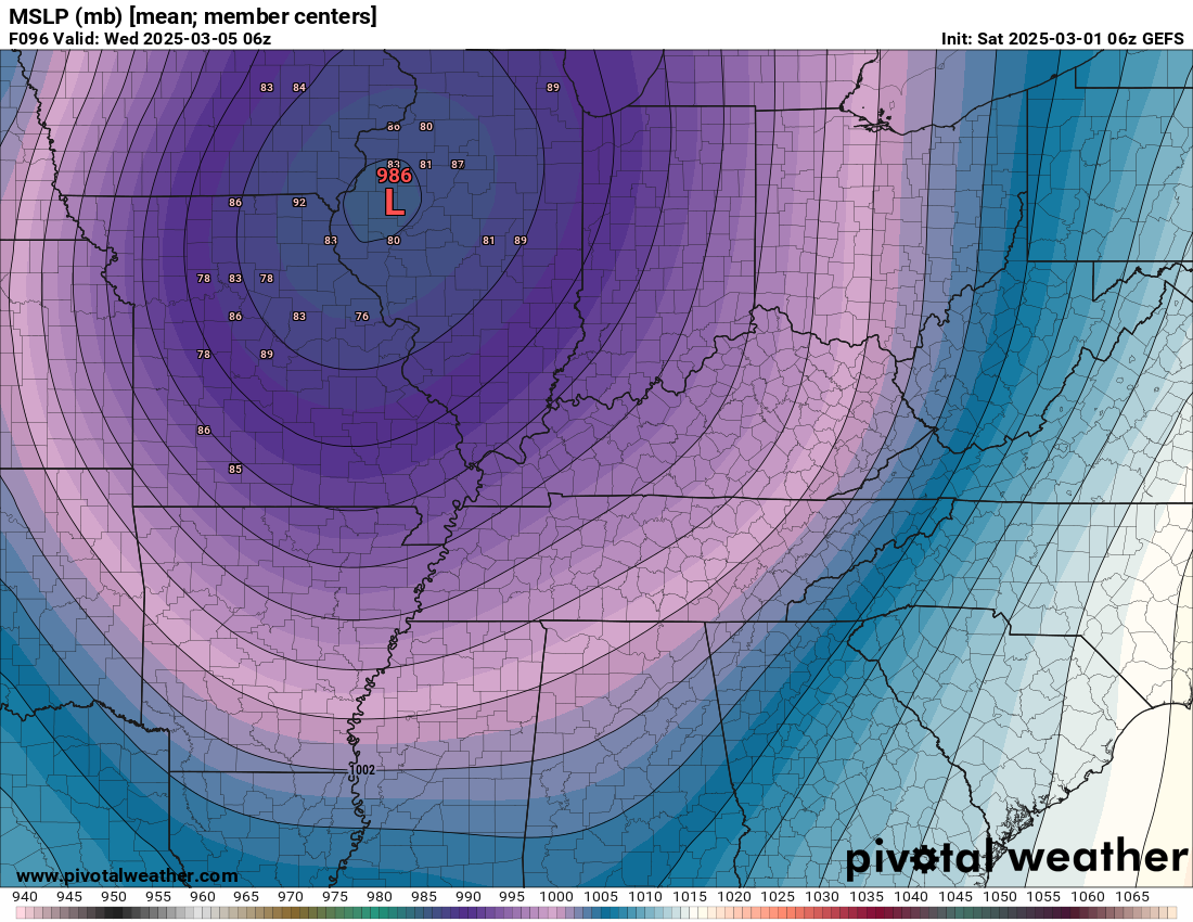
Here are the EC and GEFS ensembles. This is where the low-pressure center should track.
A track into northeast Missouri would place our region in the warm sector. That is where thunderstorms occur.
The cold sector is on the north-northwest side of the low (the red L).
EC model.
.
GEFS
.
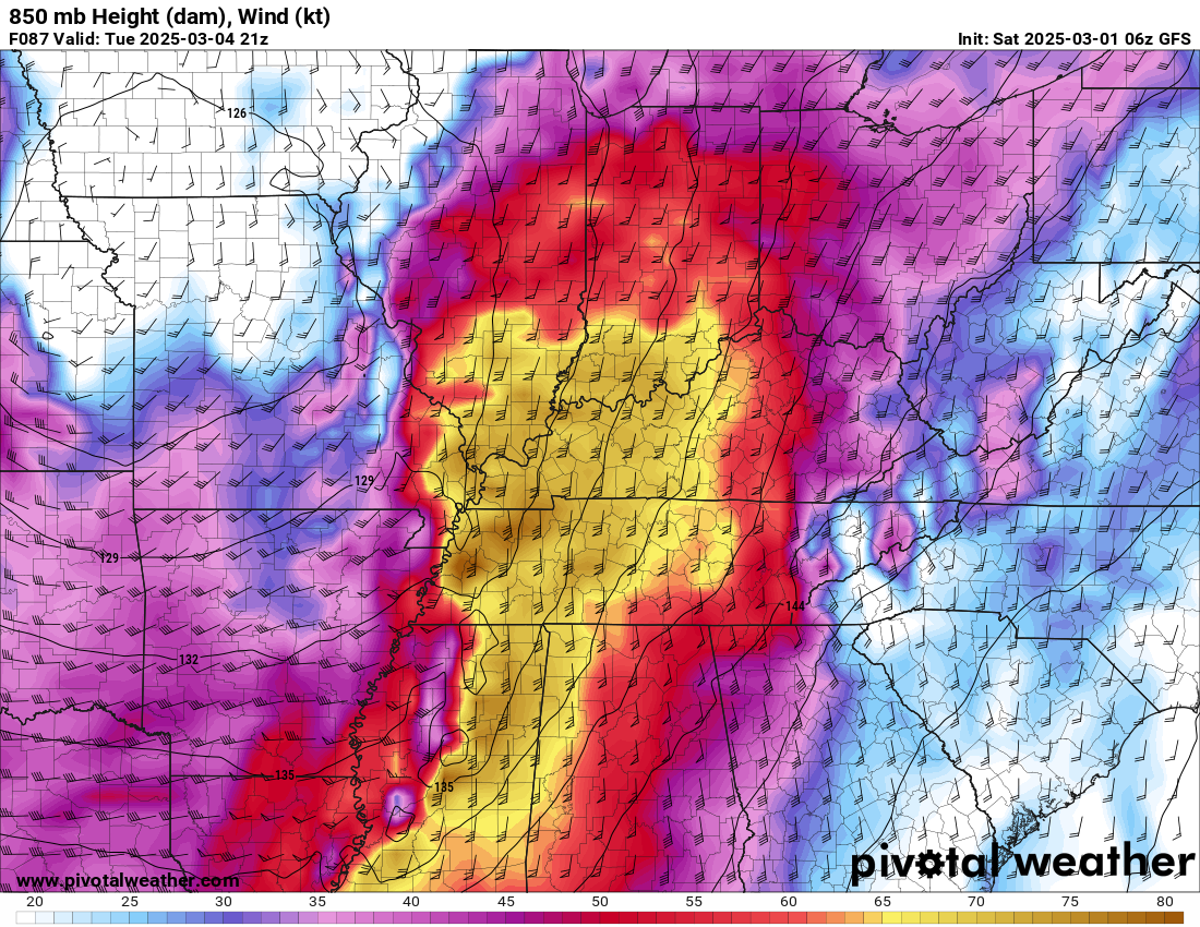
The GFS model shows a strong level-level jetstream. Strong wind fields/wind shear. This is a signal for severe weather.
GFS model. These are very strong low-level winds. Above 75 mph, several thousand feet aloft.
.
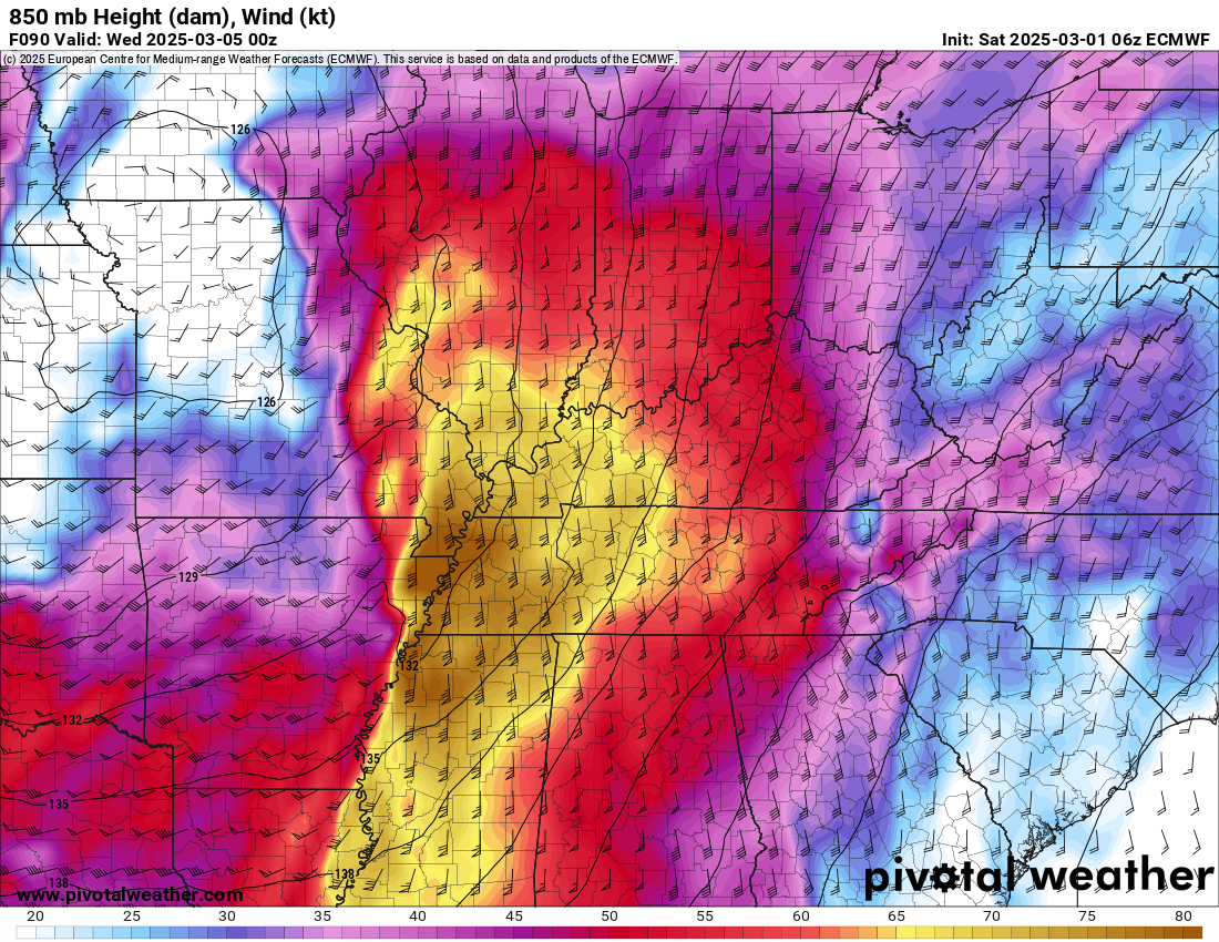
EC model 850 MB winds. Low level jetstream.
.
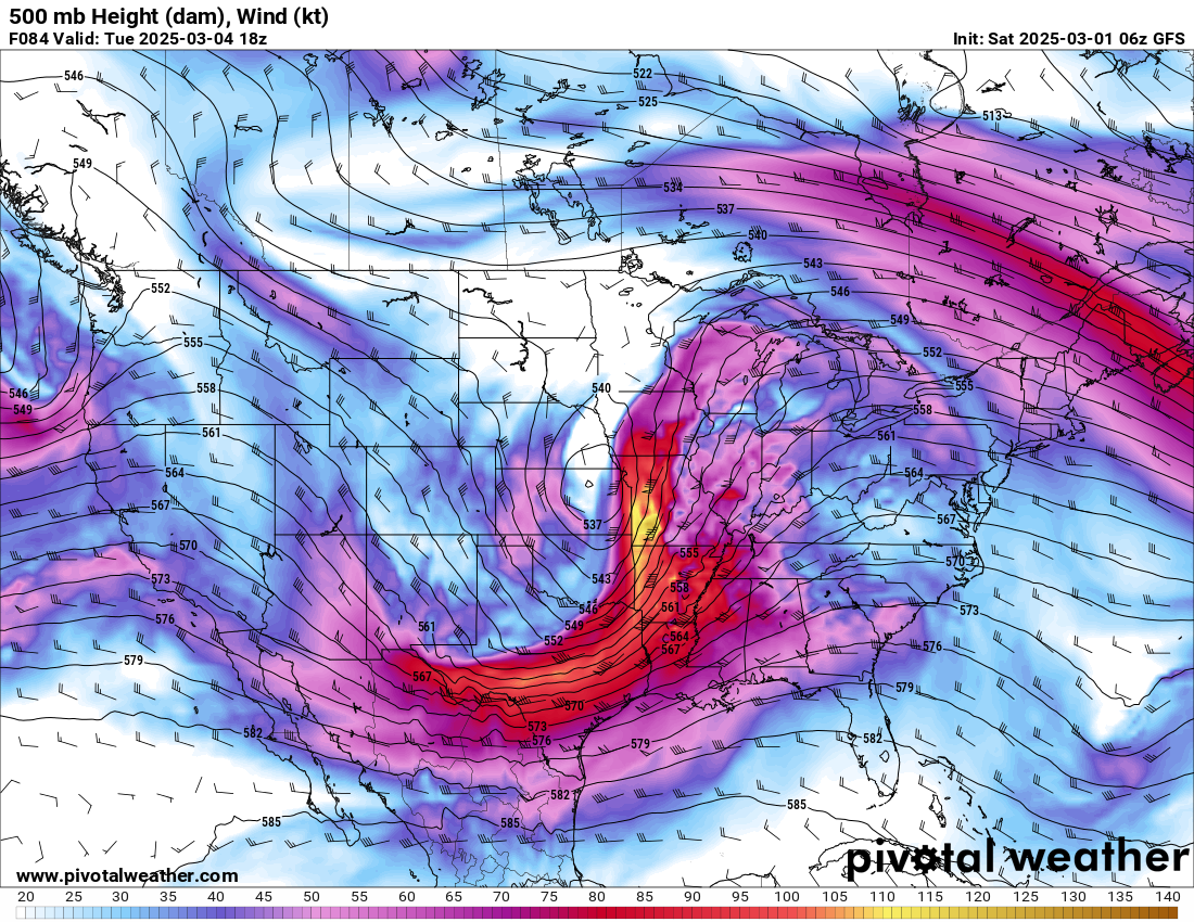
Looking higher up in the atmosphere. This is the 500 MB level jetstream. This is another signal for severe weather.
You can see the yellow streak of higher wind speeds moving into our region. Strong jetstream wind fields are a signal for severe weather.
Notice how the black lines diverge over our region. That shows a strong lifting motion.
.
Monitor updates.
.
.
.
.

Radars and Lightning Data
Interactive-city-view radars. Clickable watches and warnings.
https://wtalk.co/B3XHASFZ
Old legacy radar site (some of you like it better)
https://weatherobservatory.com/weather-radar.htm
If the radar is not updating then try another one. If a radar does not appear to be refreshing then hit Ctrl F5. You may also try restarting your browser.
Backup radar site in case the above one is not working.
https://weathertalk.com/morani
Regional Radar
https://imagery.weathertalk.com/prx/RadarLoop.mp4
** NEW ** Zoom radar with chaser tracking abilities!
ZoomRadar
If the radar is not working, then email me: Email me at beaudodson@usawx.com
.
We do have some sponsors! Check them out.
Connected and Protected.
They Specialize in Audio, Video, Networking, Security, Cameras, Electrical, New Construction, Remodels, and retrofitting Jobs. Experience the future of smart living and unmatched security with Connected & Protected Solutions today.
Link – Click here

.
Roof damage from recent storms? Link – Click here
INTEGRITY ROOFING AND EXTERIORS!
⛈️ Roof or gutter damage from recent storms? Today’s weather is sponsored by Integrity Roofing. Check out their website at this link https://www.ourintegritymatters.com/

![]()
![]()

.
Click here if you would like to return to the top of the page.
.Average high temperatures for this time of the year are around 50 degrees.
Average low temperatures for this time of the year are around 30 degrees.
Average precipitation during this time period ranges from 0.90″ to 1.20″
Six to Ten Day Outlook.
Blue is below average. Red is above average. The no color zone represents equal chances.
Average highs for this time of the year are in the lower 60s. Average lows for this time of the year are in the lower 40s.

Green is above average precipitation. Yellow and brown favors below average precipitation. Average precipitation for this time of the year is around one inch per week.

.

Average low temperatures for this time of the year are around 31degrees.
Average precipitation during this time period ranges from 0.90″ to 1.20″
.
Eight to Fourteen Day Outlook.
Blue is below average. Red is above average. The no color zone represents equal chances.

Green is above average precipitation. Yellow and brown favors below average precipitation. Average precipitation for this time of the year is around one inch per week.

.
![]()
Make sure you have three to five ways of receiving your severe weather information.
Weather Talk is one of those ways! Now, I have another product for you and your family.

.
.
https://weathercallservices.com/beau-dodson-weather


Want to add more products to your Beau Dodson Weather App?
Receive daily videos, weather blog updates on normal weather days and severe weather and winter storm days, your county by county weather forecast, and more!
Here is how to do add those additional products to your app notification settings!
Here is a video on how to update your Beau Dodson Weather payment.
The app is for subscribers. Subscribe at www.weathertalk.com/welcome then go to your app store and search for WeatherTalk
Subscribers, PLEASE USE THE APP. ATT and Verizon are not reliable during severe weather. They are delaying text messages.
The app is under WeatherTalk in the app store.

Apple users click here

Android users click here
.
Radars and Lightning Data
Interactive-city-view radars. Clickable watches and warnings.
https://wtalk.co/B3XHASFZ
Old legacy radar site (some of you like it better)
https://weatherobservatory.com/weather-radar.htm
If the radar is not updating then try another one. If a radar does not appear to be refreshing then hit Ctrl F5. You may also try restarting your browser.
Backup radar site in case the above one is not working.
https://weathertalk.com/morani
Regional Radar
https://imagery.weathertalk.com/prx/RadarLoop.mp4
** NEW ** Zoom radar with chaser tracking abilities!
ZoomRadar
Lightning Data (zoom in and out of your local area)
https://wtalk.co/WJ3SN5UZ
Not working? Email me at beaudodson@usawx.com
National map of weather watches and warnings. Click here.
Storm Prediction Center. Click here.
Weather Prediction Center. Click here.
.

Live lightning data: Click here.
Real time lightning data (another one) https://map.blitzortung.org/#5.02/37.95/-86.99
Our new Zoom radar with storm chases
.
.

Interactive GOES R satellite. Track clouds. Click here.
GOES 16 slider tool. Click here.
College of DuPage satellites. Click here
.

Here are the latest local river stage forecast numbers Click Here.
Here are the latest lake stage forecast numbers for Kentucky Lake and Lake Barkley Click Here.
.
.
Find Beau on Facebook! Click the banner.


 .
.