We have a few sponsors that are helping cover new technology costs! Check them out.
Heating problems?
One Hour Heating and Air – Click Here

Connected and Protected.
They Specialize in Audio, Video, Networking, Security, Cameras, Electrical, New Construction, Remodels, and retrofitting Jobs. Experience the future of smart living and unmatched security with Connected & Protected Solutions today.
Link – Click here

Roof damage from recent storms? Link – Click here


Click one of the links below to take you directly to that section
![]()
![]()
![]()
![]()
![]()
.

.
Seven Day Hazardous Weather Outlook
1. Is lightning in the forecast? YES. Thursday and Thursday night.
2. Are severe thunderstorms in the forecast? NOT AT THIS TIME. I will monitor Thursday.
3. Is flash flooding in the forecast? POSSIBLE. Locally heavy rain Thursday and Thursday night could cause some nuisance flooding issues. Ditches overflowing and field flooding. I can’t rule out a flood watch and/or some flood advisories. Especially if thunderstorms are embedded within the rain shield.
4. Will non-thunderstorm winds top 40 mph? NO.
6. Will the wind chill dip below 10 degrees? NO.
7. Is measurable snow and/or sleet in the forecast? NO.
8. Is freezing rain in the forecast? NO.
.

.
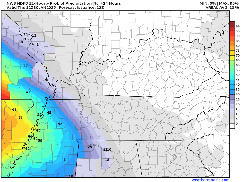
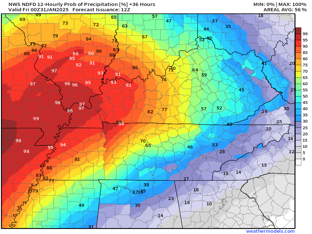
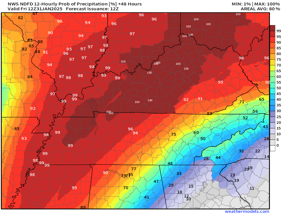
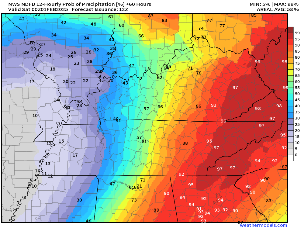
The images below are from NOAA’s Weather Prediction Center.
24-hour precipitation outlook..
 .
.
.
48-hour precipitation outlook.
.
.
Field and Brush Fire weather risk level.
Wednesday: 4. Low risk.
Wednesday night: 4. Low risk.
Thursday: 2. Very low risk.
Thursday night: 2. Very low risk.
Fire Weather Discussion
Expect moderate afternoon RH values today ranging from 35% to 50%. Dispersion looks to be fairly poor today with light winds. Tomorrow night rain chances begin to increase from southwest to northeast.Widespread wetting rains are forecast Thursday night through Friday, with rainfall totals approaching 1.5-2.5 inches.
A Haines Index of 6 means a high potential for an existing fire to become large or exhibit erratic fire behavior, 5 means medium potential, 4 means low potential, and anything less than 4 means very low potential.
.

Notes:
THE FORECAST WILL TO VARY FROM LOCATION TO LOCATION.
Scroll down to see your local forecast details.
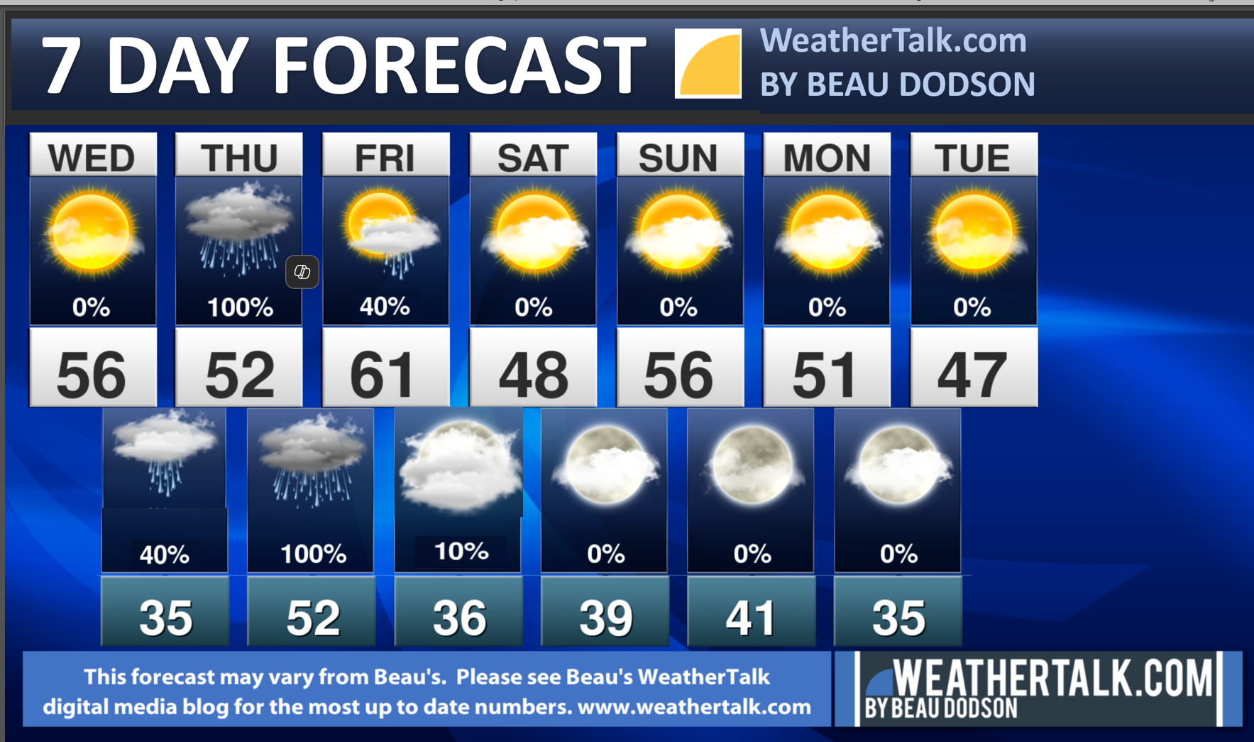
Seven-day forecast for southeast Missouri, southern Illinois, western Kentucky, and western Tennessee.
This is a BLEND for the region. Scroll further down to see the region by region forecast.
Beau’s Seven Day Video Outlook
.
A quick glance. 48-hour forecast Graphics


![]()
.
Wednesday Forecast: Partly to mostly sunny.
What is the chance of precipitation?
Far northern southeast Missouri ~ 0%
Southeast Missouri ~ 0%
The Missouri Bootheel ~ 0%
I-64 Corridor of southern Illinois ~ 0%
Southern Illinois ~ 0%
Extreme southern Illinois (southern seven counties) ~ 0%
Far western Kentucky (Purchase area) ~ 0%
The Pennyrile area of western KY ~ 0%
Northwest Kentucky (near Indiana border) ~ 0%
Northwest Tennessee ~ 0%
Coverage of precipitation:
Timing of the precipitation:
Temperature range:
Far northern southeast Missouri 54° to 56°
Southeast Missouri 55° to 56°
The Missouri Bootheel 56° to 58°
I-64 Corridor of southern Illinois 50° to 52°
Southern Illinois 52° to 55°
Extreme southern Illinois (southern seven counties) 54° to 56°
Far western Kentucky 54° to 56°
The Pennyrile area of western KY 54° to 56°
Northwest Kentucky (near Indiana border) 54° to 56°
Northwest Tennessee 54° to 56°
Winds will be from this direction: Northwest 7 to 14 mph
Wind chill or heat index (feels like) temperature forecast: 25° to 30° during the morning. In the 40s and 50s during the afternoon.
What impacts are anticipated from the weather? None
Should I cancel my outdoor plans? No
UV Index: 3. Moderate
Sunrise: 7:01 AM
Sunset: 5:17 PM
.
Wednesday Night Forecast: Increasing clouds. A chance of showers over mainly southeast Missouri.
What is the chance of precipitation?
Far northern southeast Missouri ~ 20%
Southeast Missouri ~ 30%
The Missouri Bootheel ~ 40%
I-64 Corridor of southern Illinois ~ 10%
Southern Illinois ~ 10%
Extreme southern Illinois (southern seven counties) ~ 10%
Far western Kentucky (Purchase area) ~ 20%
The Pennyrile area of western KY ~ 10%
Northwest Kentucky (near Indiana border) ~ 10%
Northwest Tennessee ~ 30%
Coverage of precipitation: Scattered
Timing of the precipitation: After midnight (increasing from the southwest moving northeast)
Temperature range:
Far northern southeast Missouri 34° to 38°
Southeast Missouri 36° to 38°
The Missouri Bootheel 36° to 40°
I-64 Corridor of southern Illinois 30° to 32°
Southern Illinois 32° to 34°
Extreme southern Illinois (southern seven counties) 34° to 36°
Far western Kentucky 34° to 36°
The Pennyrile area of western KY 34° to 36°
Northwest Kentucky (near Indiana border) 33° to 36°
Northwest Tennessee 36° to 38°
Winds will be from this direction: Light wind at 5 mph
Wind chill or heat index (feels like) temperature forecast: 28° to 38°
What impacts are anticipated from the weather? Wet roadways
Should I cancel my outdoor plans? No
Moonrise: 7:24 AM
Moonset: 5:34 PM
The phase of the moon: New
.
Thursday Forecast: Widespread rain developing from southwest to northeast. A chance of a thunderstorm.
What is the chance of precipitation?
Far northern southeast Missouri ~ 90%
Southeast Missouri ~ 100%
The Missouri Bootheel ~ 100%
I-64 Corridor of southern Illinois ~ 90%
Southern Illinois ~ 100%
Extreme southern Illinois (southern seven counties) ~ 100%
Far western Kentucky (Purchase area) ~ 100%
The Pennyrile area of western KY ~ 100%
Northwest Kentucky (near Indiana border) ~ 80%
Northwest Tennessee ~ 100%
Coverage of precipitation: Widespread
Timing of the precipitation: Any given point of time.
Temperature range:
Far northern southeast Missouri 50° to 52°
Southeast Missouri 52° to 55°
The Missouri Bootheel 56° to 60°
I-64 Corridor of southern Illinois 50° to 54°
Southern Illinois 52° to 54°
Extreme southern Illinois (southern seven counties) 54° to 58°
Far western Kentucky 54° to 58°
The Pennyrile area of western KY 54° to 58°
Northwest Kentucky (near Indiana border) 52° to 55°
Northwest Tennessee 54° to 58°
Winds will be from this direction: Southeast 10 to 20 mph
Wind chill or heat index (feels like) temperature forecast: 25° to 30° during the morning. In the 40s and 50s during the afternoon.
What impacts are anticipated from the weather? Wet roadways. Lightning. Locally heavy rain. Some low-end flooding issues possible.
Should I cancel my outdoor plans? Have a plan B and monitor the Beau Dodson Weather Radars.
UV Index: 2. Low
Sunrise: 7:00 AM
Sunset: 5:18 PM
.
Thursday Night Forecast: Cloudy. Showers and thunderstorms likely.
What is the chance of precipitation?
Far northern southeast Missouri ~ 90%
Southeast Missouri ~ 100%
The Missouri Bootheel ~ 100%
I-64 Corridor of southern Illinois ~ 90%
Southern Illinois ~ 100%
Extreme southern Illinois (southern seven counties) ~ 100%
Far western Kentucky (Purchase area) ~ 100%
The Pennyrile area of western KY ~ 100%
Northwest Kentucky (near Indiana border) ~ 100%
Northwest Tennessee ~ 100%
Coverage of precipitation: Widespread
Timing of the precipitation: Any given point of time.
Temperature range:
Far northern southeast Missouri 45° to 50°
Southeast Missouri 46° to 50°
The Missouri Bootheel 48° to 50°
I-64 Corridor of southern Illinois 46° to 48°
Southern Illinois 46° to 48°
Extreme southern Illinois (southern seven counties) 48° to 50°
Far western Kentucky 48° to 50°
The Pennyrile area of western KY 48° to 50°
Northwest Kentucky (near Indiana border) 48° to 50°
Northwest Tennessee 50° to 52°
Winds will be from this direction: South southeast at 10 to 20 mph.
Wind chill or heat index (feels like) temperature forecast: 35° to 45°
What impacts are anticipated from the weather? Wet roadways. Lightning possible. Locally heavy rain.
Should I cancel my outdoor plans? Have a plan B and monitor the Beau Dodson Weather Radars
Moonrise: 7:58 AM
Moonset: 6:47 PM
The phase of the moon: Waxing Crescent
.
Friday Forecast: A chance of showers. The rain will be ending.
What is the chance of precipitation?
Far northern southeast Missouri ~ 20%
Southeast Missouri ~ 20%
The Missouri Bootheel ~ 20%
I-64 Corridor of southern Illinois ~ 30%
Southern Illinois ~ 30%
Extreme southern Illinois (southern seven counties) ~ 30%
Far western Kentucky (Purchase area) ~ 30%
The Pennyrile area of western KY ~ 40%
Northwest Kentucky (near Indiana border) ~ 40%
Northwest Tennessee ~ 30%
Coverage of precipitation: Scattered
Timing of the precipitation: Mainly during the morning.
Temperature range:
Far northern southeast Missouri 55° to 60°
Southeast Missouri 55° to 60°
The Missouri Bootheel 58° to 60°
I-64 Corridor of southern Illinois 55° to 60°
Southern Illinois 55° to 60°
Extreme southern Illinois (southern seven counties) 55° to 60°
Far western Kentucky 55° to 60°
The Pennyrile area of western KY 56° to 60°
Northwest Kentucky (near Indiana border) 55° to 60°
Northwest Tennessee 56° to 60°
Winds will be from this direction: West southwest at 10 to 20 mph. Gusty.
Wind chill or heat index (feels like) temperature forecast: 38° to 48° during the morning. In the 50s during the afternoon.
What impacts are anticipated from the weather? Wet roadways.
Should I cancel my outdoor plans? No, but monitor the Beau Dodson Weather Radars.
UV Index: 3. Moderate.
Sunrise: 6:59 AM
Sunset: 5:19 PM
.
Friday Night Forecast: Partly cloudy.
What is the chance of precipitation?
Far northern southeast Missouri ~ 0%
Southeast Missouri ~ 0%
The Missouri Bootheel ~ 0%
I-64 Corridor of southern Illinois ~ 0%
Southern Illinois ~ 0%
Extreme southern Illinois (southern seven counties) ~ 0%
Far western Kentucky (Purchase area) ~ 0%
The Pennyrile area of western KY ~ 0%
Northwest Kentucky (near Indiana border) ~ 0%
Northwest Tennessee ~ 0%
Coverage of precipitation:
Timing of the precipitation:
Temperature range:
Far northern southeast Missouri 30° to 32°
Southeast Missouri 34° to 38°
The Missouri Bootheel 38° to 40°
I-64 Corridor of southern Illinois 30° to 32°
Southern Illinois 32° to 34°
Extreme southern Illinois (southern seven counties) 32° to 34°
Far western Kentucky 32° to 34°
The Pennyrile area of western KY 32° to 34°
Northwest Kentucky (near Indiana border) 32° to 34°
Northwest Tennessee 32° to 34°
Winds will be from this direction: Northwest at 10 to 20 mph
Wind chill or heat index (feels like) temperature forecast: 22° to 32°
What impacts are anticipated from the weather?
Should I cancel my outdoor plans? No
Moonrise: 6:25 AM
Moonset: 8:00 PM
The phase of the moon: Waxing Crescent
.
Click here if you would like to return to the top of the page.

Do you have any suggestions or comments? Email me at beaudodson@usawx.com
.
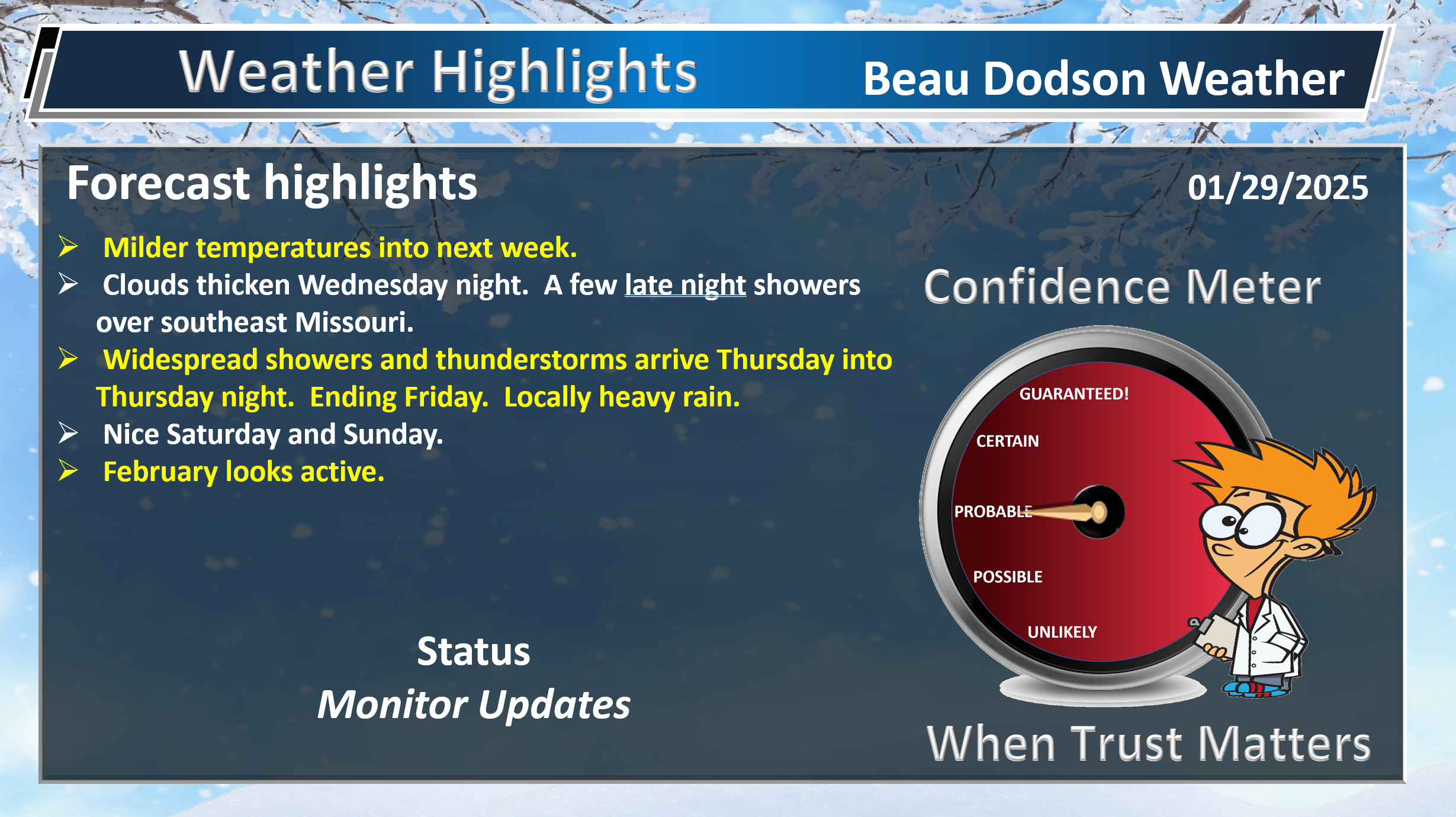
Weather Highlights and Forecast Discussion
-
- Mild temperatures over the coming days. Watching colder air next week, but confidence is low.
- Widespread rain arrives late Wednesday night into Thursday night. Ending Friday. The system has sped up. Locally heavy rain. A few thunderstorms.
- A few storms could be strong, but the risk of severe weather is low.
- Some nuisance flooding is possible.
- February looks active.
.
Beau’s Forecast Discussion
Radars and Lightning Data
Interactive-city-view radars. Clickable watches and warnings.
https://wtalk.co/B3XHASFZ
Old legacy radar site (some of you like it better)
https://weatherobservatory.com/weather-radar.htm
If the radar is not updating then try another one. If a radar does not appear to be refreshing then hit Ctrl F5. You may also try restarting your browser.
Backup radar site in case the above one is not working.
https://weathertalk.com/morani
Regional Radar
https://imagery.weathertalk.com/prx/RadarLoop.mp4
** NEW ** Zoom radar with chaser tracking abilities!
ZoomRadar
Lightning Data (zoom in and out of your local area)
https://wtalk.co/WJ3SN5UZ
.
Good day, everyone
We have some active weather ahead of us. Widespread rain. A few storms.
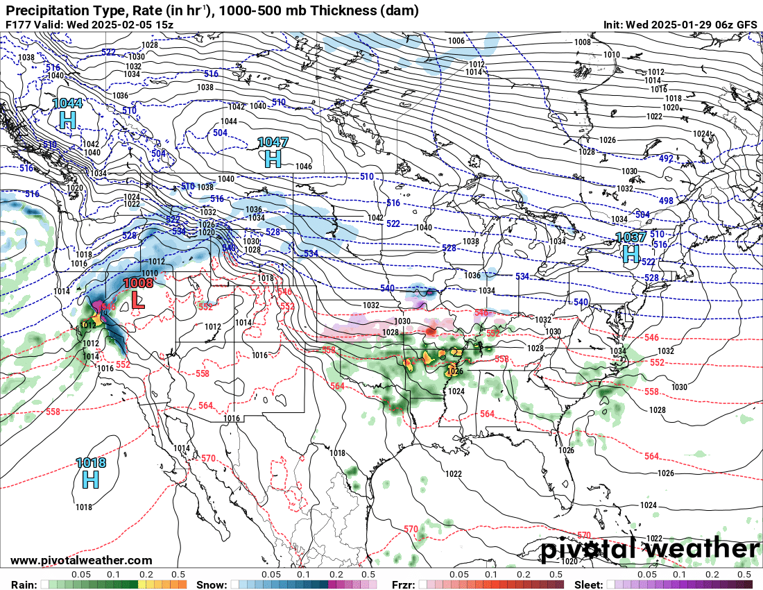
An area of low pressure is developing to our west. This will pull moisture northward tonight into tomorrow night.
Rain will develop over Texas and Oklahoma today. It will rapidly expand into Louisiana, Arkansas, and Missouri tonight. Moving northeast.
The system continues to speed up a bit. The rain will arrive in southeast Missouri tonight and then overspread the region tomorrow.
The rain will continue into Thursday night. Ending on Friday.
Locally heavy rain is likely with this system.
Models have shown a fairly consistent signal for a widespread one to two inches of rain. Then, pockets of two to three inches. Locally higher.
This is enough rain to cause some flooding concerns. Mainly nuisance flooding.
Commonly flooded roadways could have issues. Field flooding possible. Sharp rises on streams. Ditches may overflow.
Avoid flooded roadways.
The National Weather Service thought about issuing a flood watch, but they held off. Mainly because of confidence in the placement of the heaviest rain.
A flood watch has been issued for portions of Missouri and Arkansas. Outside of my forecast zone.
Double click images to enlarge them.
Here is what the WPC/NOAA is forecasting for rain totals. That red band is two inches or higher. That zips right across our region.
Double click the image to enlarge it.
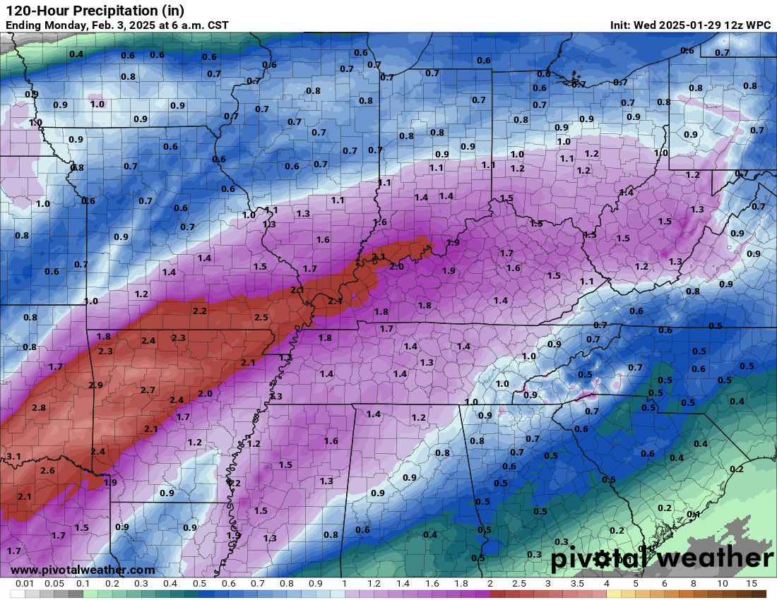
The NAM model is a bit farther north with the heaviest rain, but it is the outlier. It has been consistently farther north with the heavier rain placement. I am not sure why, but the NAM model seems to struggle with these systems.
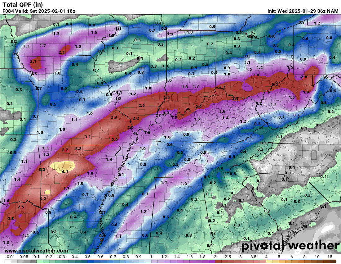
The GFS and EC model line up more with the official rainfall forecast from the WPC. This lines up with my forecast, as well.
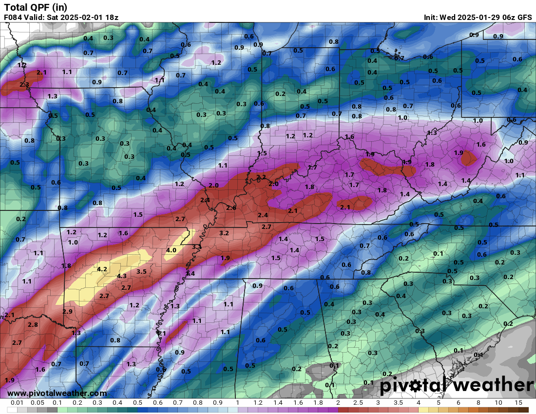
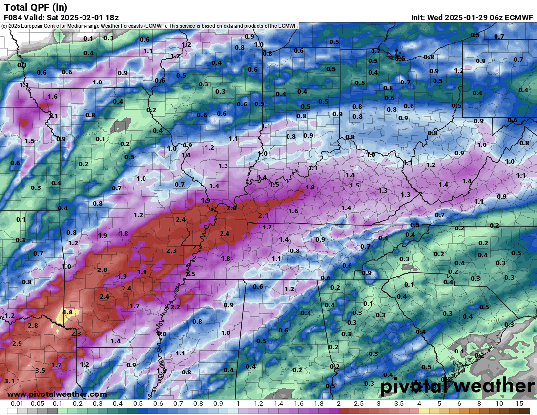
So, you get the general idea on rainfall totals. A few embedded thunderstorms are possible, as well.
Again, this could be enough rain to cause some nuisance flooding. Ditches overflowing, field flooding, commonly flooded roadways that flood could flood.
The ground is still thawing from our recent cold weather. That could mean a bit more runoff than normal.
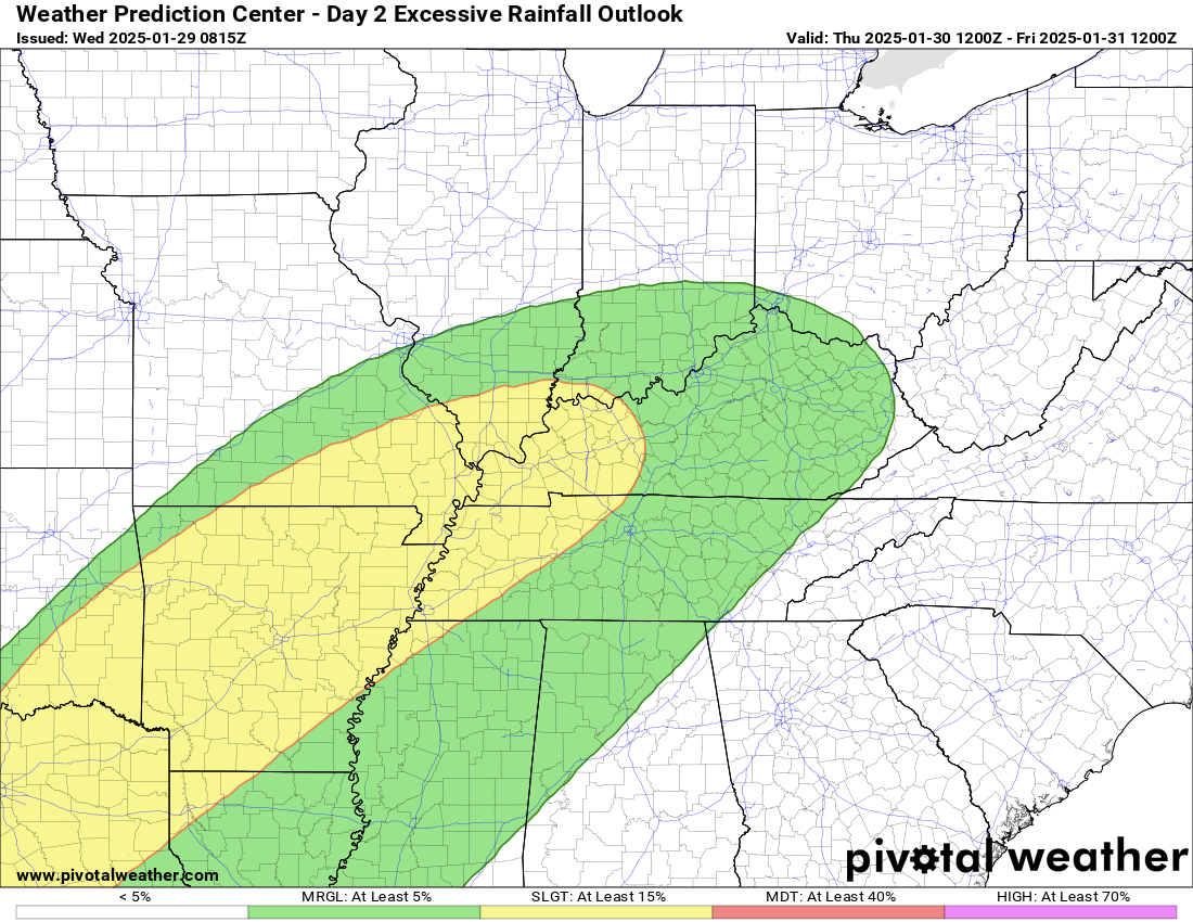
We are in a marginal and slight risk of excessive rainfall. NOAA/WPC issues this product.
This just means that some areas could have enough rain to cause low end flooding issues.
Severe thunderstorms are currently not anticipated.
I will keep a close eye on where the SPC places the marginal risk of severe weather.
It could come close to our southern counties. Especially if the systems shifts slightly northward.
The concern would be damaging wind gusts. For now, I am not concerned. I will update if anything changes.
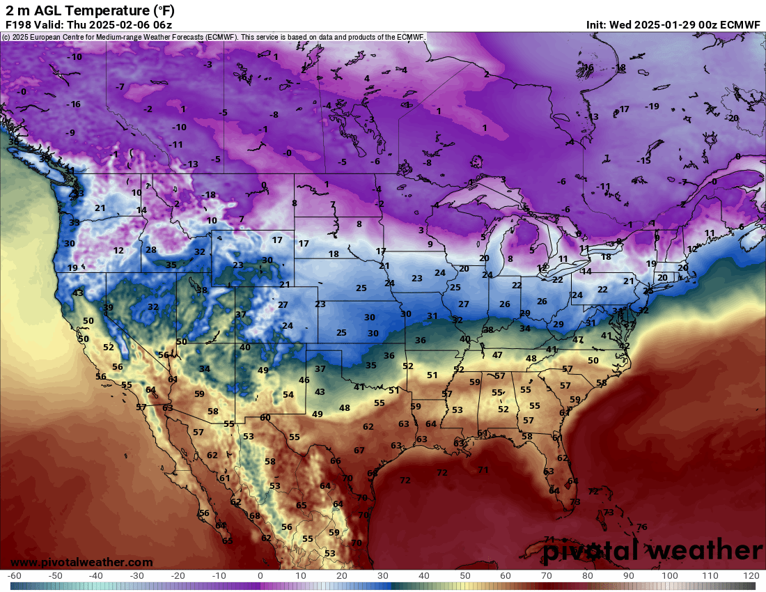
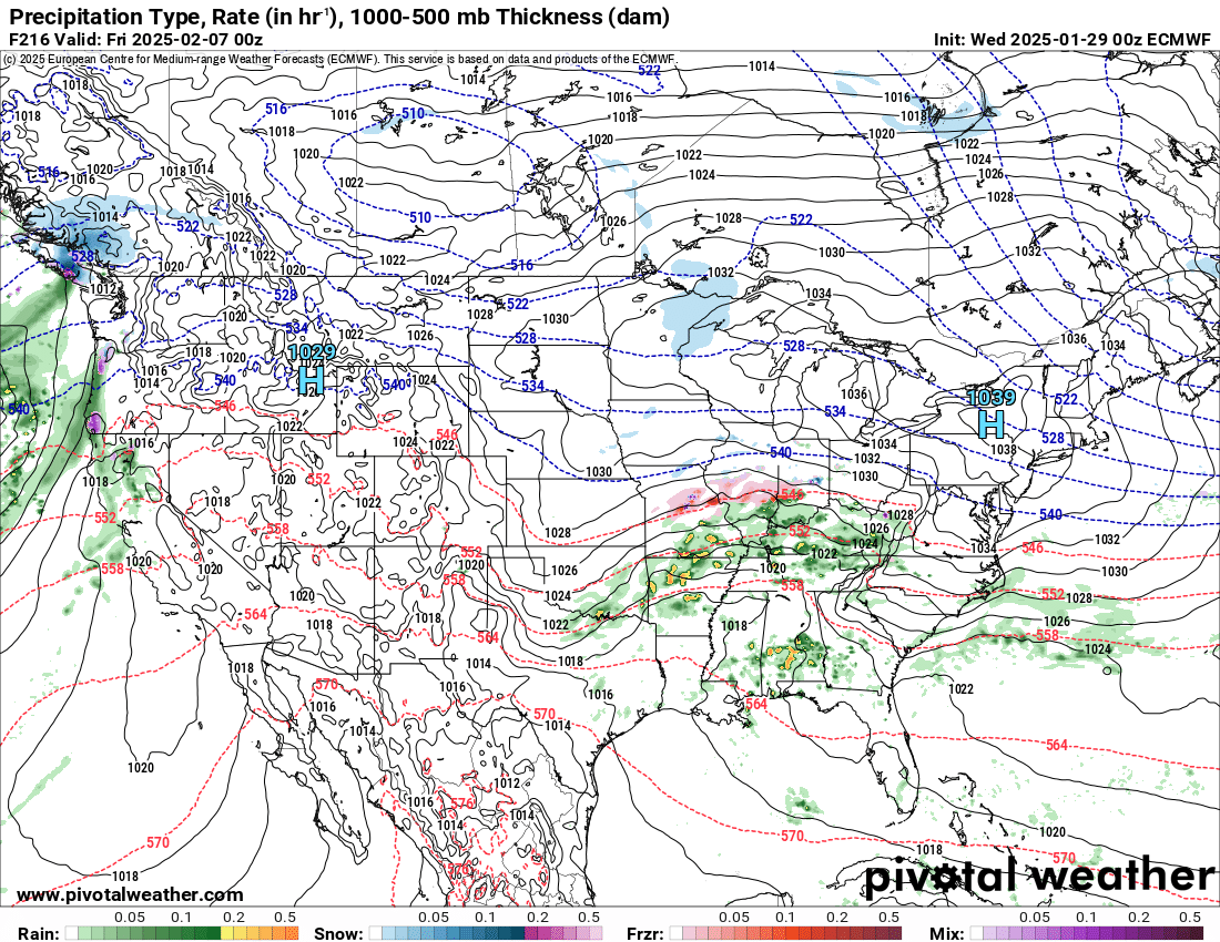
I am watching another system around February 6th.
There remain questions about how far south an Arctic front will shift. Where it shifts is where the snow and ice will occur.,
This is a classic ice storm setup. Just a question of where.
Check out the GFS and EC model temperatures. You can see that Arctic front.
That shallow cold air is where overrunning moisture could produce sleet and ice.
Double click the image to enlarge it.
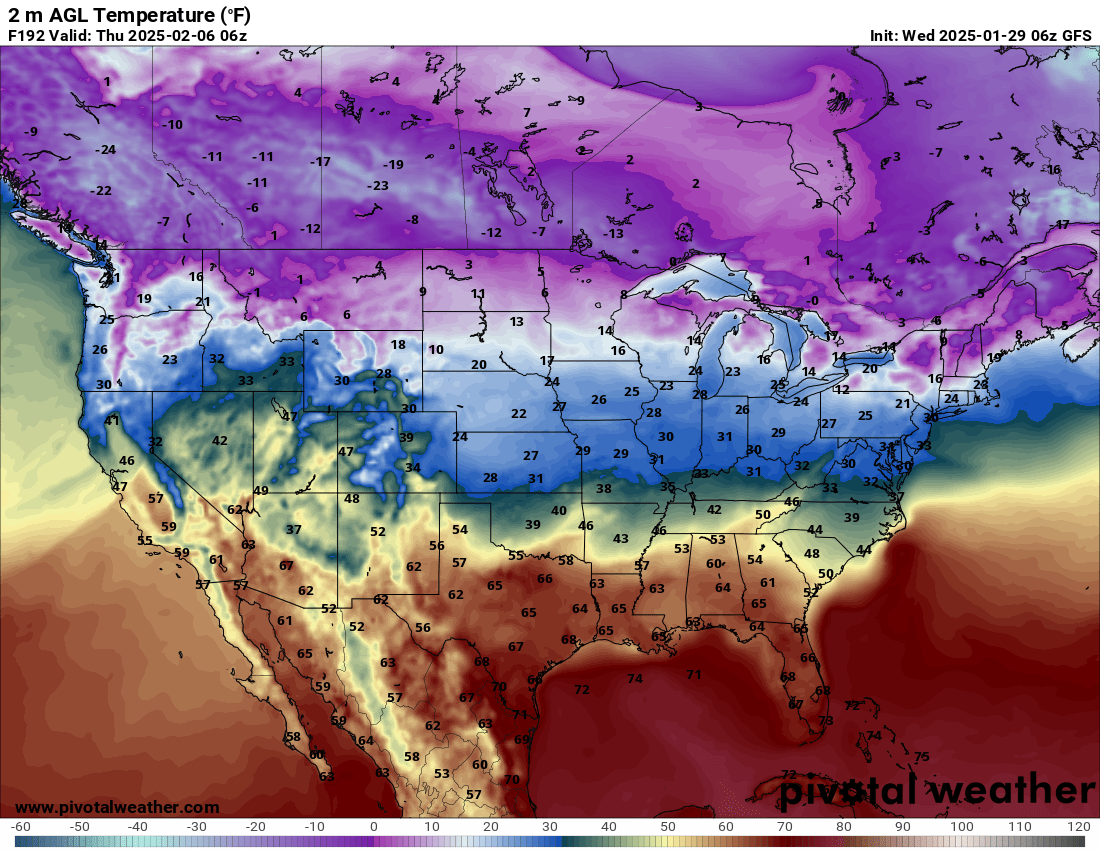
EC
Here are the four primary models.
Hrrr high-res model
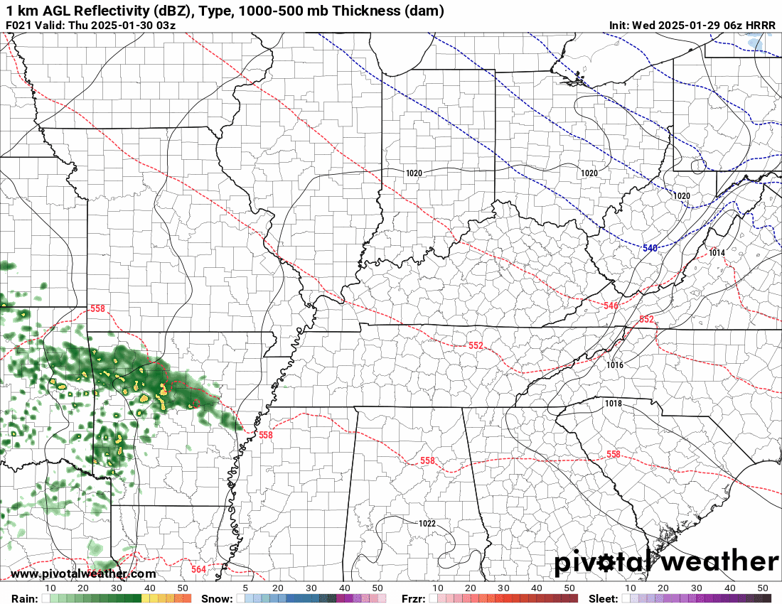
.
Canadian model shows rain.

GFS model shows a wintry mix.
EC model shows a wintry mix and rain.
.
I continue to watch the cold air well to our north over the next two weeks.
At times, that cold air could ooze its way southward.
Whether we have snow or ice in February remains a question. Models have backed off a bit on the cold air.
I will need to watch trends for now.
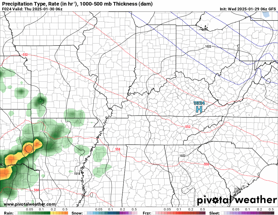
.Let’s Look At The Future-cast Radar
Time stamp is in Zulu. 00z=6 pm. 06z=12 am. 12z=6 am. 18z=12 pm.
GFS American Model. Double click the animation to enlarge it.
This is the rain event tonight into tomorrow night.
.
And the EC European model
This is the rain event tonight into tomorrow night.

.![]()
.
Click here if you would like to return to the top of the page.
This outlook covers southeast Missouri, southern Illinois, western Kentucky, and far northwest Tennessee.

.
Today’s Storm Prediction Center’s (SPC) Severe Weather Outlook
Light green is where thunderstorms may occur but should be below severe levels.
Dark green is a level one risk. Yellow is a level two risk. Orange is a level three (enhanced) risk. Red is a level four (moderate) risk. Pink is a level five (high) risk.
One is the lowest risk. Five is the highest risk.
A severe storm is one that produces 58 mph wind or higher, quarter or larger size hail, and/or a tornado.
Explanation of tables. Click here.
Day One Severe Weather Outlook

Day One Severe Weather Outlook. Zoomed in on our region.

.
Day One Tornado Probability Outlook

Day One Regional Tornado Outlook. Zoomed in on our region.

.
Day One Large Hail Probability Outlook

Day One Regional Hail Outlook. Zoomed in on our region.

.
Day One High wind Probability Outlook

Day One Regional Wind Outlook. Zoomed in on our region.

.
Tomorrow’s severe weather outlook. Day two outlook.

Day Two Outlook. Zoomed in on our region.

.
Day Three Severe Weather Outlook

.
![]()
..![]()

.
Click here if you would like to return to the top of the page.
.Average high temperatures for this time of the year are around 44 degrees.
Average low temperatures for this time of the year are around 27 degrees.
Average precipitation during this time period ranges from 0.90″ to 1.20″
Six to Ten Day Outlook.
Blue is below average. Red is above average. The no color zone represents equal chances.
Average highs for this time of the year are in the lower 60s. Average lows for this time of the year are in the lower 40s.

Green is above average precipitation. Yellow and brown favors below average precipitation. Average precipitation for this time of the year is around one inch per week.

.

Average low temperatures for this time of the year are around 27 degrees.
Average precipitation during this time period ranges from 0.90″ to 1.20″
.
Eight to Fourteen Day Outlook.
Blue is below average. Red is above average. The no color zone represents equal chances.

Green is above average precipitation. Yellow and brown favors below average precipitation. Average precipitation for this time of the year is around one inch per week.

.
![]()
Make sure you have three to five ways of receiving your severe weather information.
Weather Talk is one of those ways! Now, I have another product for you and your family.

.
.
https://weathercallservices.com/beau-dodson-weather


Want to add more products to your Beau Dodson Weather App?
Receive daily videos, weather blog updates on normal weather days and severe weather and winter storm days, your county by county weather forecast, and more!
Here is how to do add those additional products to your app notification settings!
Here is a video on how to update your Beau Dodson Weather payment.
The app is for subscribers. Subscribe at www.weathertalk.com/welcome then go to your app store and search for WeatherTalk
Subscribers, PLEASE USE THE APP. ATT and Verizon are not reliable during severe weather. They are delaying text messages.
The app is under WeatherTalk in the app store.

Apple users click here

Android users click here
.

Radars and Lightning Data
Interactive-city-view radars. Clickable watches and warnings.
https://wtalk.co/B3XHASFZ
Old legacy radar site (some of you like it better)
https://weatherobservatory.com/weather-radar.htm
If the radar is not updating then try another one. If a radar does not appear to be refreshing then hit Ctrl F5. You may also try restarting your browser.
Backup radar site in case the above one is not working.
https://weathertalk.com/morani
Regional Radar
https://imagery.weathertalk.com/prx/RadarLoop.mp4
** NEW ** Zoom radar with chaser tracking abilities!
ZoomRadar
Lightning Data (zoom in and out of your local area)
https://wtalk.co/WJ3SN5UZ
Not working? Email me at beaudodson@usawx.com
National map of weather watches and warnings. Click here.
Storm Prediction Center. Click here.
Weather Prediction Center. Click here.
.

Live lightning data: Click here.
Real time lightning data (another one) https://map.blitzortung.org/#5.02/37.95/-86.99
Our new Zoom radar with storm chases
.
.

Interactive GOES R satellite. Track clouds. Click here.
GOES 16 slider tool. Click here.
College of DuPage satellites. Click here
.

Here are the latest local river stage forecast numbers Click Here.
Here are the latest lake stage forecast numbers for Kentucky Lake and Lake Barkley Click Here.
.
.
Find Beau on Facebook! Click the banner.


 .
.