
Click one of the links below to take you directly to that section
![]()
![]()
![]()
![]()
![]()
![]()
![]()
.

.
Seven Day Hazardous Weather Outlook
1. Is lightning in the forecast? LOW RISK. Sunday night.
2. Are severe thunderstorms in the forecast? NO.
3. Is flash flooding in the forecast? NO.
4. Will non-thunderstorm winds top 40 mph? NO.
5. Will temperatures drop below 32 degrees? YES. Temperatures will drop below freezing tonight. Temperatures will drop below freezing Tuesday, Wednesday, and Thursday night of next week. I will monitor next Friday.
6. Will the wind chill dip below 10 degrees? YES. Wind chill values this morning will be below ten degrees.
7. Is measurable snow and/or sleet in the forecast? NOT AT THIS TIME
8. Is freezing rain/ice in the forecast? NOT AT THIS TIME .
.
Want to add more products to your WeatherTalk account? Receive daily videos, blog updates, your counties weather forecast, and more!
Here is how to do that!
If you have not updated your WeatherTalk payment, then please do so.
We still have several expired credit cards.
Here is how to fix that.
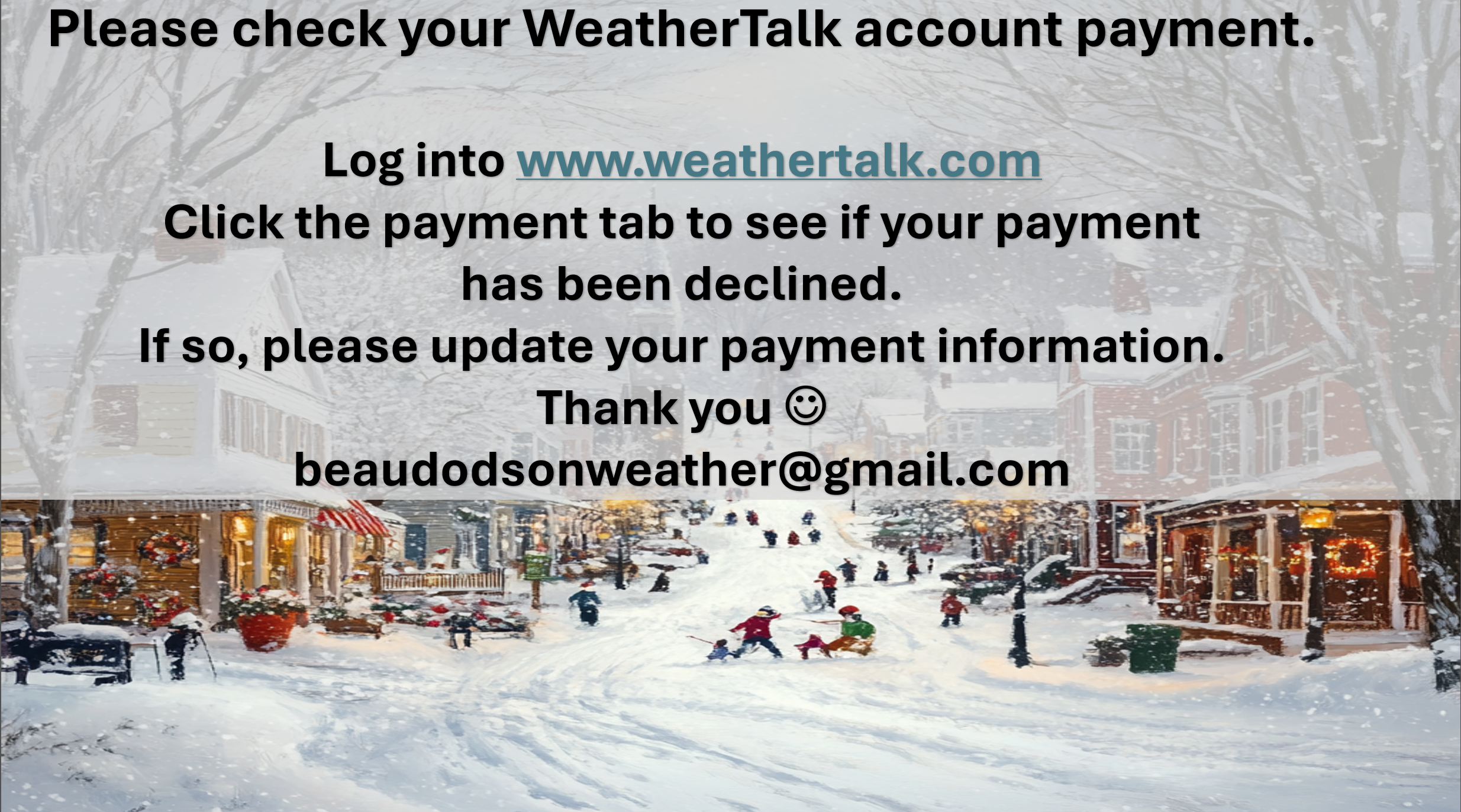
Here is a video on how to update your payment.
.
Fire weather risk level.
Friday: 4. Low risk.
Friday night: 4. Low risk.
Saturday: 3. Very low risk.
Sunday night: 4. Low risk.
Fire Weather Discussion
Mixing heights today will be 2200-2800 feet, with light winds, poor dispersion and minimum afternoon humidity around 30-35%. Mixing heights Saturday will be near to below 1700 feet with afternoon humidity of 35-45% and poor dispersion. Wetting rains will arrive Sunday night.
A Haines Index of 6 means a high potential for an existing fire to become large or exhibit erratic fire behavior, 5means medium potential, 4 means low potential, and anything less than 4 means very low potential.
.

THE FORECAST IS GOING TO VARY FROM LOCATION TO LOCATION.
Scroll down to see your local forecast details.
Seven-day forecast for southeast Missouri, southern Illinois, western Kentucky, and western Tennessee.
This is a BLEND for the region. Scroll down to see the region by region forecast.
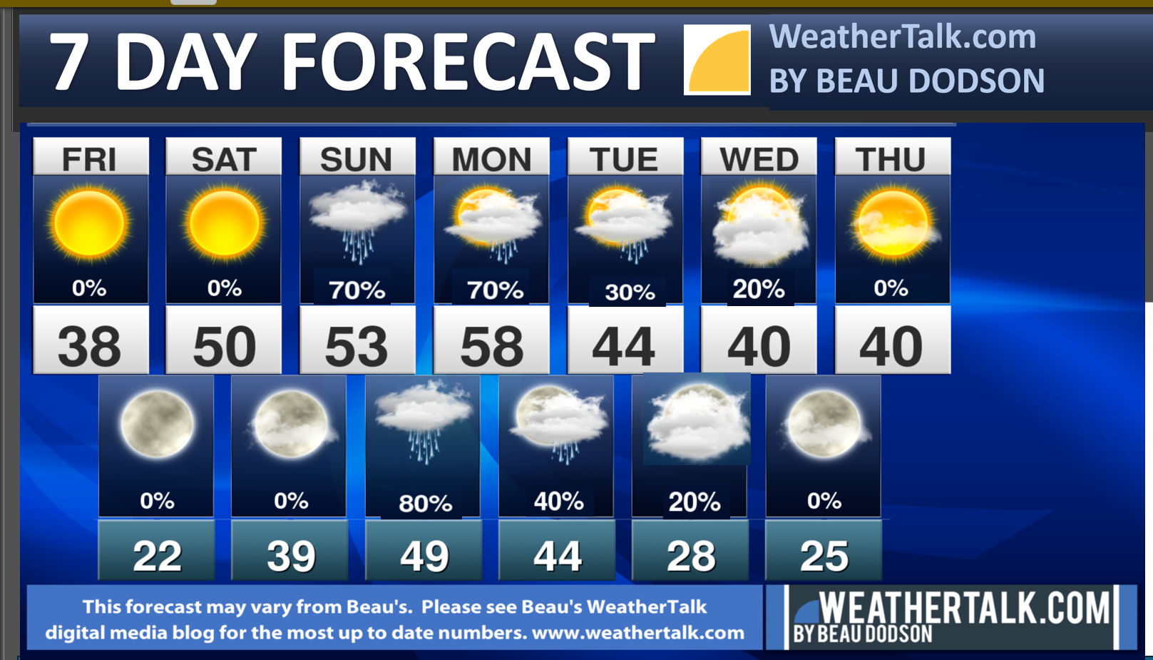
Beau’s Seven Day Video Outlook
.
48-hour forecast Graphics


.
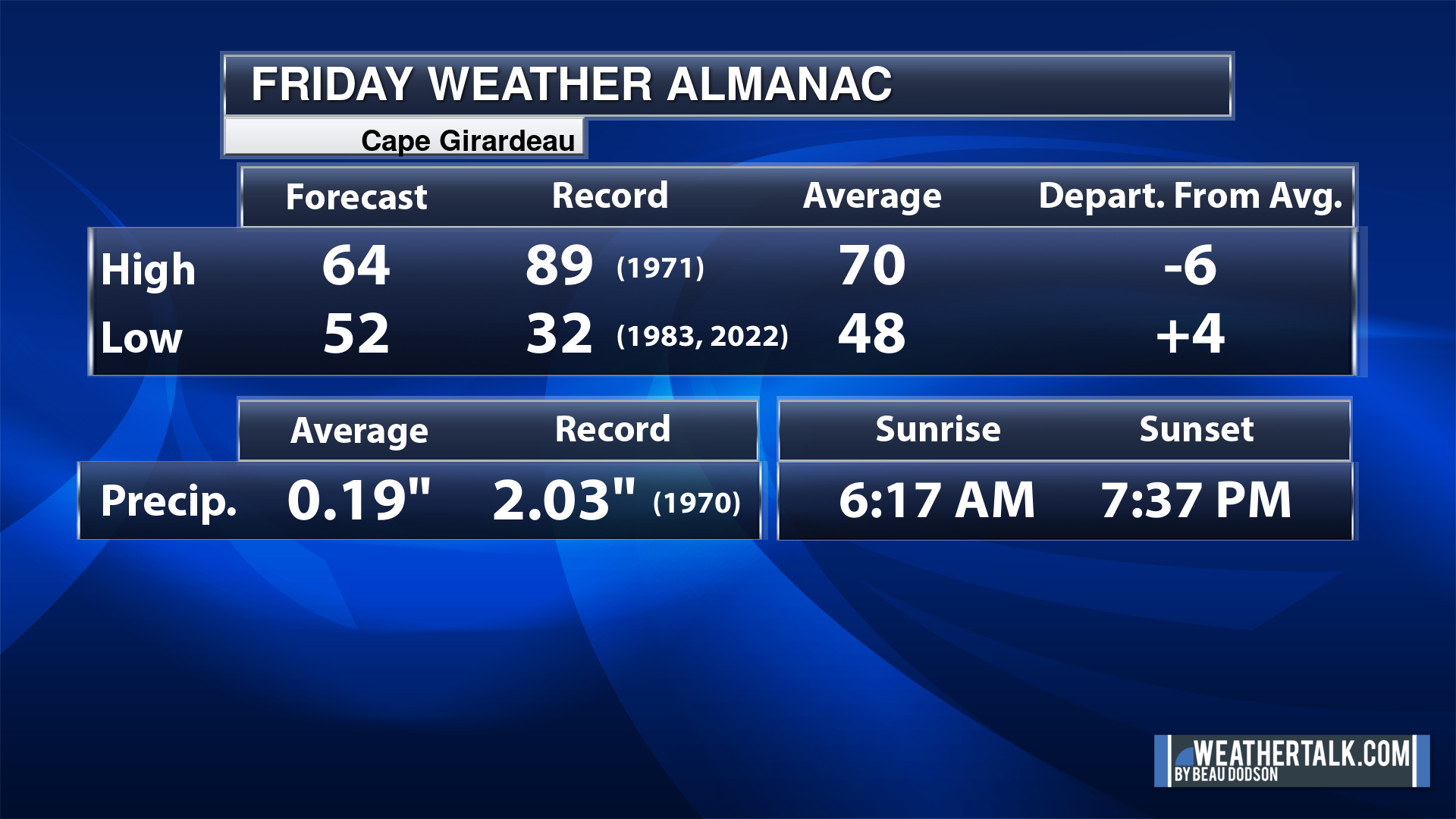
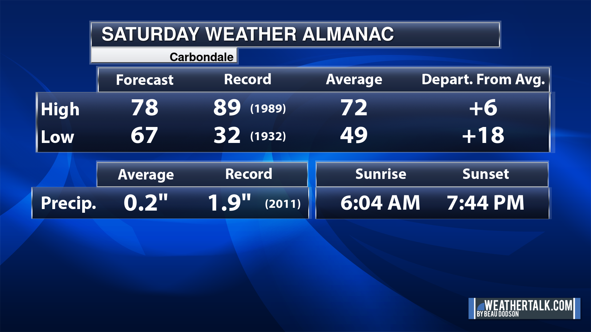
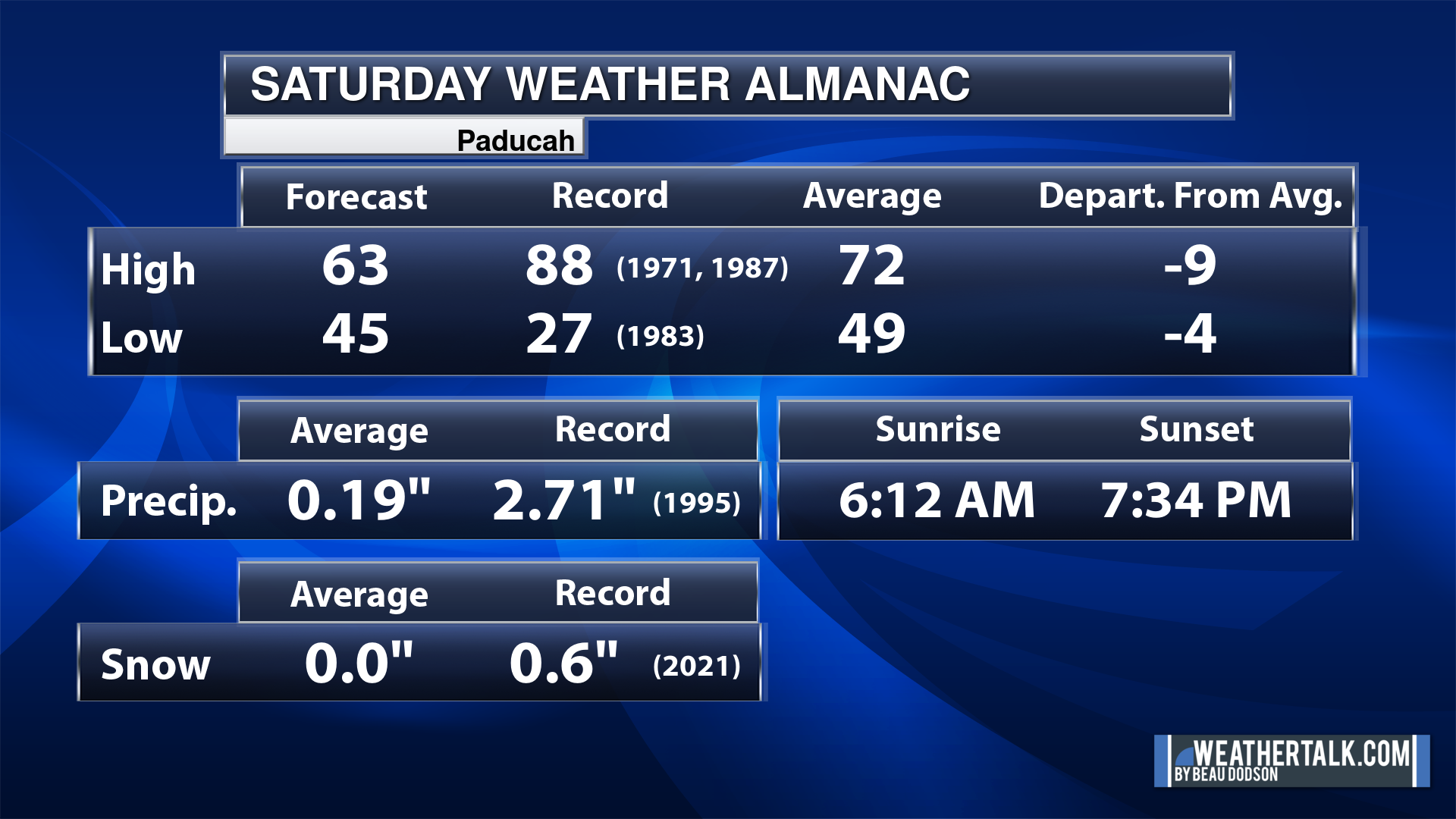
Today’s Local Almanacs (for a few select cities). Your location will be comparable.
Note, the low is this morning’s low and not tomorrows.
The forecast temperature shows you today’s expected high and this morning’s low.
The graphic shows you the record high and record low for today. It shows you what year that occurred, as well.
It then shows you what today’s average temperature is.
It shows you the departures (how may degrees above or below average temperatures will be ).
It shows you the average precipitation for today. Average comes from thirty years of rain totals.
It also shows you the record rainfall for the date and what year that occurred.
The sunrise and sunset are also shown.


![]()
.
.
Friday Forecast: Mostly sunny during the morning. Some afternoon clouds. Cold.
What is the chance of precipitation?
Far northern southeast Missouri ~ 0%
Southeast Missouri ~ 0%
The Missouri Bootheel ~ 0%
I-64 Corridor of southern Illinois ~ 0%
Southern Illinois ~ 0%
Extreme southern Illinois (southern seven counties) ~ 0%
Far western Kentucky (Purchase area) ~ 0%
The Pennyrile area of western KY ~ 0%
Northwest Kentucky (near Indiana border) ~ 0%
Northwest Tennessee ~ 0%
Coverage of precipitation:
Timing of the precipitation:
Temperature range:
Far northern southeast Missouri ~ 34° to 38°
Southeast Missouri ~ 34° to 38°
The Missouri Bootheel ~ 36° to 40°
I-64 Corridor of southern Illinois ~ 33° to 36°
Southern Illinois ~ 34° to 38°
Extreme southern Illinois (southern seven counties) ~ 34° to 38°
Far western Kentucky ~ 34° to 38°
The Pennyrile area of western KY ~ 36° to 40°
Northwest Kentucky (near Indiana border) ~ 36° to 38°
Northwest Tennessee ~ 34° to 38°
Winds will be from this direction: Becoming southwest 7 to 14 mph
Wind chill or heat index (feels like) temperature forecast: 15° to 30° (coldest before 9 am)
What impacts are anticipated from the weather?
Should I cancel my outdoor plans?
UV Index: 2. Low.
Sunrise: 6:56 AM
Sunset: 4:37 PM
.
Friday Night Forecast: Partly cloudy. Cold.
What is the chance of precipitation?
Far northern southeast Missouri ~ 0%
Southeast Missouri ~ 0%
The Missouri Bootheel ~ 0%
I-64 Corridor of southern Illinois ~ 0%
Southern Illinois ~ 0%
Extreme southern Illinois (southern seven counties) ~ 0%
Far western Kentucky (Purchase area) ~ 0%
The Pennyrile area of western KY ~ 0%
Northwest Kentucky (near Indiana border) ~ 0%
Northwest Tennessee ~ 0%
Coverage of precipitation:
Timing of the precipitation:
Temperature range:
Far northern southeast Missouri ~ 18° to 22°
Southeast Missouri ~ 24° to 26°
The Missouri Bootheel ~ 24° to 28°
I-64 Corridor of southern Illinois ~ 18° to 22°
Southern Illinois ~20° to 24°
Extreme southern Illinois (southern seven counties) ~ 22° to 24°
Far western Kentucky ~ 22° to 24°
The Pennyrile area of western KY ~ 22° to 25°
Northwest Kentucky (near Indiana border) ~ 22° to 24°
Northwest Tennessee ~ 24° to 28°
Winds will be from this direction: Southwest 6 to 12 mph
Wind chill or heat index (feels like) temperature forecast: 10° to 20°
What impacts are anticipated from the weather?
Should I cancel my outdoor plans?
Moonrise: 11:26 AM
Moonset: 10:00 PM
The phase of the moon: Waxing Crescent
.
Saturday Forecast: Mostly sunny during the morning. Some afternoon clouds. Not as cold.
What is the chance of precipitation?
Far northern southeast Missouri ~ 0%
Southeast Missouri ~ 0%
The Missouri Bootheel ~ 0%
I-64 Corridor of southern Illinois ~ 0%
Southern Illinois ~ 0%
Extreme southern Illinois (southern seven counties) ~ 0%
Far western Kentucky (Purchase area) ~ 0%
The Pennyrile area of western KY ~ 0%
Northwest Kentucky (near Indiana border) ~ 0%
Northwest Tennessee ~ 0%
Coverage of precipitation:
Timing of the precipitation:
Temperature range:
Far northern southeast Missouri ~ 52° to 55°
Southeast Missouri ~ 50° to 52°
The Missouri Bootheel ~ 52° to 54°
I-64 Corridor of southern Illinois ~ 48° to 52°
Southern Illinois ~ 48° to 50°
Extreme southern Illinois (southern seven counties) ~ 48° to 50°
Far western Kentucky ~ 48° to 50°
The Pennyrile area of western KY ~ 48° to 50°
Northwest Kentucky (near Indiana border) ~ 48° to 50°
Northwest Tennessee ~ 48° to 52°
Winds will be from this direction: South 10 to 15 mph
Wind chill or heat index (feels like) temperature forecast: 44° to 52° (colder before 8 am)
What impacts are anticipated from the weather?
Should I cancel my outdoor plans?
UV Index: 2. Low.
Sunrise: 6:57 AM
Sunset: 4:37 PM
.
Saturday Night Forecast: Increasing clouds.
What is the chance of precipitation?
Far northern southeast Missouri ~ 0%
Southeast Missouri ~ 0%
The Missouri Bootheel ~ 10%
I-64 Corridor of southern Illinois ~ 0%
Southern Illinois ~ 0%
Extreme southern Illinois (southern seven counties) ~ 0%
Far western Kentucky (Purchase area) ~ 0%
The Pennyrile area of western KY ~ 0%
Northwest Kentucky (near Indiana border) ~ 0%
Northwest Tennessee ~ 0%
Coverage of precipitation:
Timing of the precipitation:
Temperature range:
Far northern southeast Missouri ~ 36° to 40°
Southeast Missouri ~ 36° to 40°
The Missouri Bootheel ~ 35° to 40°
I-64 Corridor of southern Illinois ~ 35° to 38°
Southern Illinois ~ 35° to 40°
Extreme southern Illinois (southern seven counties) ~ 35° to 40°
Far western Kentucky ~ 35° to 40°
The Pennyrile area of western KY ~ 35° to 40°
Northwest Kentucky (near Indiana border) ~ 35° to 40°
Northwest Tennessee ~ 35° to 40°
Winds will be from this direction: South southwest 10 to 20 mph. Gusty.
Wind chill or heat index (feels like) temperature forecast: 32° to 38°
What impacts are anticipated from the weather?
Should I cancel my outdoor plans? No
Moonrise: 11:55 AM
Moonset: 11:10 PM
The phase of the moon: Waxing Crescent
.
Sunday Forecast: Mostly cloudy. A chance of showers.
What is the chance of precipitation?
Far northern southeast Missouri ~ 30%
Southeast Missouri ~ 30%
The Missouri Bootheel ~ 70%
I-64 Corridor of southern Illinois ~ 30%
Southern Illinois ~ 40%
Extreme southern Illinois (southern seven counties) ~ 60%
Far western Kentucky (Purchase area) ~ 60%
The Pennyrile area of western KY ~ 60%
Northwest Kentucky (near Indiana border) ~ 40%
Northwest Tennessee ~ 70%
Coverage of precipitation: Scattered (increasing coverage as we move through the day)
Timing of the precipitation: Any given point of time, but more likely late at night
Temperature range:
Far northern southeast Missouri ~ 55° to 60°
Southeast Missouri ~ 55° to 00°
The Missouri Bootheel ~ 55° to 00°
I-64 Corridor of southern Illinois ~ 55° to 00°
Southern Illinois ~ 55° to 00°
Extreme southern Illinois (southern seven counties) ~ 55° to 00°
Far western Kentucky ~ 55° to 00°
The Pennyrile area of western KY ~ 55° to 00°
Northwest Kentucky (near Indiana border) ~ 55° to 00°
Northwest Tennessee ~ 55° to 00°
Winds will be from this direction: South 10 to 25 mph
Wind chill or heat index (feels like) temperature forecast: 50° to 55°
What impacts are anticipated from the weather? Wet roadways.
Should I cancel my outdoor plans? No, but monitor updates and the Beau Dodson Weather Radars (link bottom of the page)
UV Index: 1. Low.
Sunrise: 6:57 AM
Sunset: 4:37 PM
.
Sunday Night Forecast: Cloudy. A chance of showers. A thunderstorm is possible.
What is the chance of precipitation?
Far northern southeast Missouri ~ 60%
Southeast Missouri ~ 70%
The Missouri Bootheel ~ 90%
I-64 Corridor of southern Illinois ~ 80%
Southern Illinois ~ 80%
Extreme southern Illinois (southern seven counties) ~ 90%
Far western Kentucky (Purchase area) ~ 90%
The Pennyrile area of western KY ~ 90%
Northwest Kentucky (near Indiana border) ~ 90%
Northwest Tennessee ~ 100%
Coverage of precipitation: Widespread
Timing of the precipitation: Any given point of time.
Temperature range:
Far northern southeast Missouri ~ 44° to 48°
Southeast Missouri ~ 44° to 48°
The Missouri Bootheel ~ 48° to 50°
I-64 Corridor of southern Illinois ~ 44° to 48°
Southern Illinois ~ 46° to 48°
Extreme southern Illinois (southern seven counties) ~ 46° to 48°
Far western Kentucky ~ 46° to 48°
The Pennyrile area of western KY ~ 46° to 48°
Northwest Kentucky (near Indiana border) ~ 44° to 48°
Northwest Tennessee ~ 48° to 60°
Winds will be from this direction: South southwest 10 to 20 mph.
Wind chill or heat index (feels like) temperature forecast: 44° to 48°
What impacts are anticipated from the weather? Wet roadways. Lightning.
Should I cancel my outdoor plans? Have a plan B and monitor the Beau Dodson Weather Radars.
Moonrise: 12:22 PM
Moonset:
The phase of the moon: First Quarter
.
Monday Forecast: Mostly cloudy. A chance of showers.
What is the chance of precipitation?
Far northern southeast Missouri ~ 20%
Southeast Missouri ~ 20%
The Missouri Bootheel ~ 30%
I-64 Corridor of southern Illinois ~ 30%
Southern Illinois ~ 40%
Extreme southern Illinois (southern seven counties) ~ 40%
Far western Kentucky (Purchase area) ~ 40%
The Pennyrile area of western KY ~ 70%
Northwest Kentucky (near Indiana border) ~ 70%
Northwest Tennessee ~ 60%
Coverage of precipitation: Numerous
Timing of the precipitation: Any given point of time
Temperature range:
Far northern southeast Missouri ~ 56° to 60°
Southeast Missouri ~ 56° to 60°
The Missouri Bootheel ~ 56° to 60°
I-64 Corridor of southern Illinois ~ 56° to 60°
Southern Illinois ~ 56° to 60°
Extreme southern Illinois (southern seven counties) ~ 56° to 60°
Far western Kentucky ~ 56° to 60°
The Pennyrile area of western KY ~ 56° to 60°
Northwest Kentucky (near Indiana border) ~ 56° to 60°
Northwest Tennessee ~ 56° to 60°
Winds will be from this direction: South southwest 10 to 20 mph
Wind chill or heat index (feels like) temperature forecast: 55° to 60°
What impacts are anticipated from the weather? Wet roadways. A small chance of lightning.
Should I cancel my outdoor plans? Have a plan B and monitor the Beau Dodson Weather Radars
UV Index: 1. Low.
Sunrise: 6:58 AM
Sunset: 4:37 PM
.
Monday Night Forecast: Mostly cloudy. A chance of showers.
What is the chance of precipitation?
Far northern southeast Missouri ~ 20%
Southeast Missouri ~ 20%
The Missouri Bootheel ~ 20%
I-64 Corridor of southern Illinois ~ 30%
Southern Illinois ~ 30%
Extreme southern Illinois (southern seven counties) ~ 40%
Far western Kentucky (Purchase area) ~ 40%
The Pennyrile area of western KY ~ 60%
Northwest Kentucky (near Indiana border) ~ 40%
Northwest Tennessee ~ 40%
Coverage of precipitation: Scattered
Timing of the precipitation: Any given point of time.
Temperature range:
Far northern southeast Missouri ~ 34° to 38°
Southeast Missouri ~ 34° to 38°
The Missouri Bootheel ~ 44° to 46°
I-64 Corridor of southern Illinois ~ 34° to 38°
Southern Illinois ~ 36° to 40°
Extreme southern Illinois (southern seven counties) ~ 38° to 42°
Far western Kentucky ~ 38° to 42°
The Pennyrile area of western KY ~38° to 42°
Northwest Kentucky (near Indiana border) ~ 36° to 40°
Northwest Tennessee ~ 38° to 42°
Winds will be from this direction: West northwest at 8 to 16 mph
Wind chill or heat index (feels like) temperature forecast: 34° to 38°
What impacts are anticipated from the weather? Wet roadways.
Should I cancel my outdoor plans? No, but monitor the Beau Dodson Weather Radars.
Moonrise: 12:48 PM
Moonset: 12:19 AM
The phase of the moon: Waxing Gibbous
.
Tuesday Forecast: Partly cloudy. A chance of showers.
What is the chance of precipitation?
Far northern southeast Missouri ~ 10%
Southeast Missouri ~ 10%
The Missouri Bootheel ~ 20%
I-64 Corridor of southern Illinois ~ 20%
Southern Illinois ~ 20%
Extreme southern Illinois (southern seven counties) ~ 30%
Far western Kentucky (Purchase area) ~ 30%
The Pennyrile area of western KY ~ 30%
Northwest Kentucky (near Indiana border) ~ 30%
Northwest Tennessee ~ 30%
Coverage of precipitation: Widely scattered
Timing of the precipitation: Any given point of time
Temperature range:
Far northern southeast Missouri ~ 45° to 50°
Southeast Missouri ~ 45° to 50°
The Missouri Bootheel ~ 45° to 50°
I-64 Corridor of southern Illinois ~ 45° to 50°
Southern Illinois ~ 45° to 50°
Extreme southern Illinois (southern seven counties) ~ 45° to 50°
Far western Kentucky ~ 45° to 50°
The Pennyrile area of western KY ~ 45° to 50°
Northwest Kentucky (near Indiana border) ~ 45° to 50°
Northwest Tennessee ~ 45° to 50°
Winds will be from this direction: North northwest 8 to 16 mph
Wind chill or heat index (feels like) temperature forecast: 40° to 45°
What impacts are anticipated from the weather? Wet roadways.
Should I cancel my outdoor plans? No, but monitor the Beau Dodson Weather Radars
UV Index: 2. Low.
Sunrise: 6:59 AM
Sunset: 4:37 PM
.
Tuesday Night Forecast: Partly cloudy. A slight chance of rain or snow.
What is the chance of precipitation?
Far northern southeast Missouri ~ 10%
Southeast Missouri ~ 10%
The Missouri Bootheel ~ 10%
I-64 Corridor of southern Illinois ~ 20%
Southern Illinois ~ 20%
Extreme southern Illinois (southern seven counties) ~ 20%
Far western Kentucky (Purchase area) ~ 20%
The Pennyrile area of western KY ~ 20%
Northwest Kentucky (near Indiana border) ~ 20%
Northwest Tennessee ~ 20%
Coverage of precipitation: Isolated
Timing of the precipitation: Any given point of time
Temperature range:
Far northern southeast Missouri ~ 22° to 25°
Southeast Missouri ~ 22° to 25°
The Missouri Bootheel ~ 26° to 28°
I-64 Corridor of southern Illinois ~ 22° to 25°
Southern Illinois ~ 22° to 25°
Extreme southern Illinois (southern seven counties) ~ 24° to 26°
Far western Kentucky ~ 24° to 26°
The Pennyrile area of western KY ~ 24° to 26°
Northwest Kentucky (near Indiana border) ~ 22° to 25°
Northwest Tennessee ~ 24° to 26°
Winds will be from this direction: North northwest 7 to 14 mph
Wind chill or heat index (feels like) temperature forecast: 18° to 24°
What impacts are anticipated from the weather? Monitor
Should I cancel my outdoor plans? No, but monitor updates
Moonrise: 1:14 PM
Moonset: 1:29 AM
The phase of the moon: Waxing Gibbous
.
Wednesday Forecast: Partly sunny.
What is the chance of precipitation?
Far northern southeast Missouri ~ 10%
Southeast Missouri ~ 10%
The Missouri Bootheel ~ 10%
I-64 Corridor of southern Illinois ~ 10%
Southern Illinois ~ 10%
Extreme southern Illinois (southern seven counties) ~ 10%
Far western Kentucky (Purchase area) ~ 10%
The Pennyrile area of western KY ~ 10%
Northwest Kentucky (near Indiana border) ~ 10%
Northwest Tennessee ~ 10%
Coverage of precipitation:
Timing of the precipitation:
Temperature range:
Far northern southeast Missouri ~ 38° to 42°
Southeast Missouri ~ 38° to 42°
The Missouri Bootheel ~ 38° to 42°
I-64 Corridor of southern Illinois ~ 38° to 42°
Southern Illinois ~ 38° to 42°
Extreme southern Illinois (southern seven counties) ~ 38° to 42°
Far western Kentucky ~ 38° to 42°
The Pennyrile area of western KY ~38° to 42°
Northwest Kentucky (near Indiana border) ~ 38° to 42°
Northwest Tennessee ~ 38° to 42°
Winds will be from this direction: North northwest 6 to 12 mph
Wind chill or heat index (feels like) temperature forecast: 34° to 40°
What impacts are anticipated from the weather?
Should I cancel my outdoor plans? No
UV Index: 2. Low.
Sunrise: 7:00 AM
Sunset: 4:38 PM
.
Wednesday Night Forecast: Partly cloudy.
What is the chance of precipitation?
Far northern southeast Missouri ~ 10%
Southeast Missouri ~ 10%
The Missouri Bootheel ~ 10%
I-64 Corridor of southern Illinois ~ 10%
Southern Illinois ~ 10%
Extreme southern Illinois (southern seven counties) ~ 10%
Far western Kentucky (Purchase area) ~ 10%
The Pennyrile area of western KY ~ 10%
Northwest Kentucky (near Indiana border) ~ 10%
Northwest Tennessee ~ 10%
Coverage of precipitation:
Timing of the precipitation:
Temperature range:
Far northern southeast Missouri ~ 20° to 24°
Southeast Missouri ~ 20° to 24°
The Missouri Bootheel ~ 20° to 24°
I-64 Corridor of southern Illinois ~ 20° to 24°
Southern Illinois ~ 20° to 24°
Extreme southern Illinois (southern seven counties) ~ 20° to 24°
Far western Kentucky ~ 20° to 24°
The Pennyrile area of western KY ~ 20° to 24°
Northwest Kentucky (near Indiana border) ~ 20° to 24°
Northwest Tennessee ~ 20° to 24°
Winds will be from this direction: North northwest 5 to 10 mph
Wind chill or heat index (feels like) temperature forecast: 20° to 24°
What impacts are anticipated from the weather?
Should I cancel my outdoor plans? No
Moonrise: 1:43 PM
Moonset: 2:41 AM
The phase of the moon: Waxing Gibbous
.
Click here if you would like to return to the top of the page.

Do you have any suggestions or comments? Email me at beaudodson@usawx.com
Make sure you have three to five ways of receiving your severe weather information.
Weather Talk is one of those ways.

.
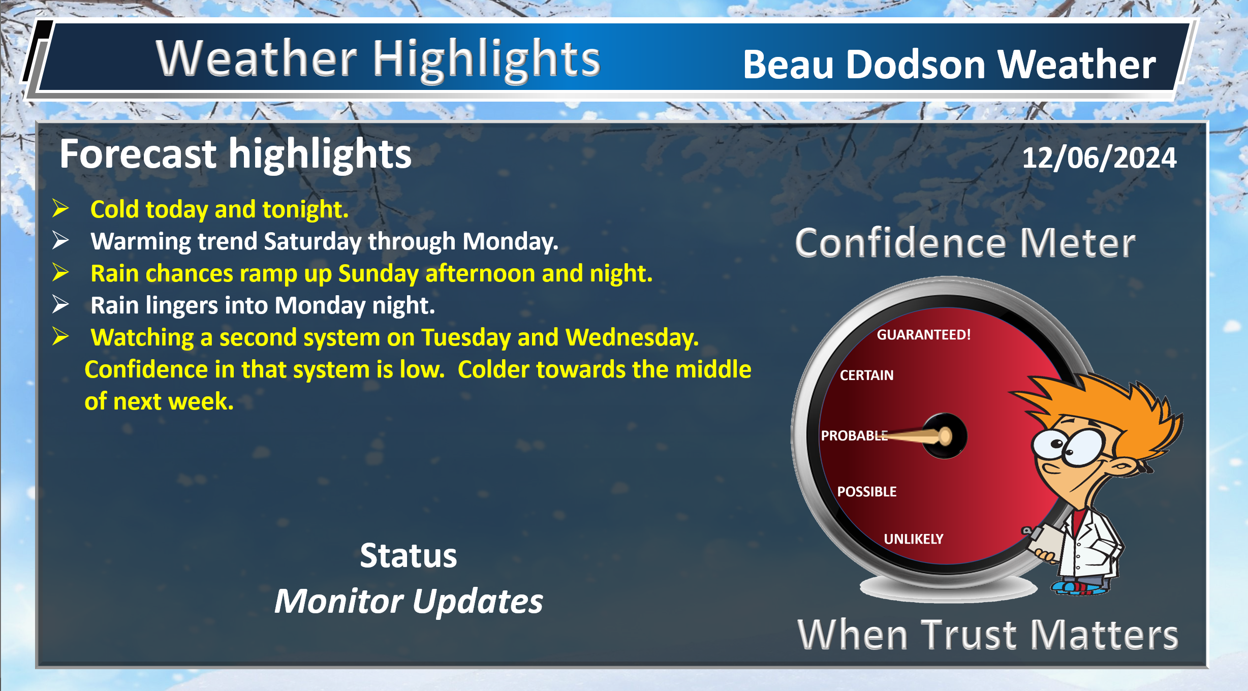
Weather Highlights and Forecast Discussion
-
- Cold today. A bitterly cold morning.
- Cold tonight.
- A warming trend Saturday into Monday.
- Rain chances return Sunday into Monday night. Peak chances will be Sunday afternoon and night.
- I will monitor precipitation chances Tuesday and Wednesday.
Beau’s Forecast Discussion
As a reminder.
Kids at the bus stop this week will need to be bundled up. Wind chill values today and tomorrow will range from the single digits to the teens. Brrr.
.
Good morning, everyone.
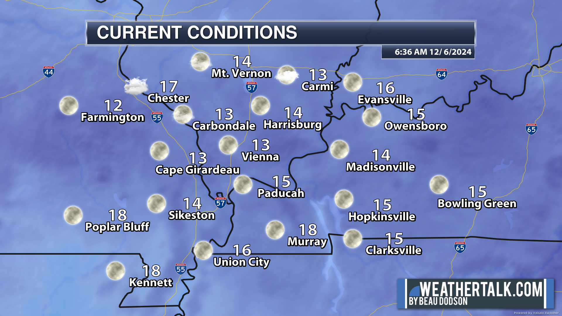
It is cold this morning. Temperatures are still falling as I type this. Our northern counties will approach 10 degrees. Brrr.
Widespread teens this morning.
Here is the 6 am temperature map.
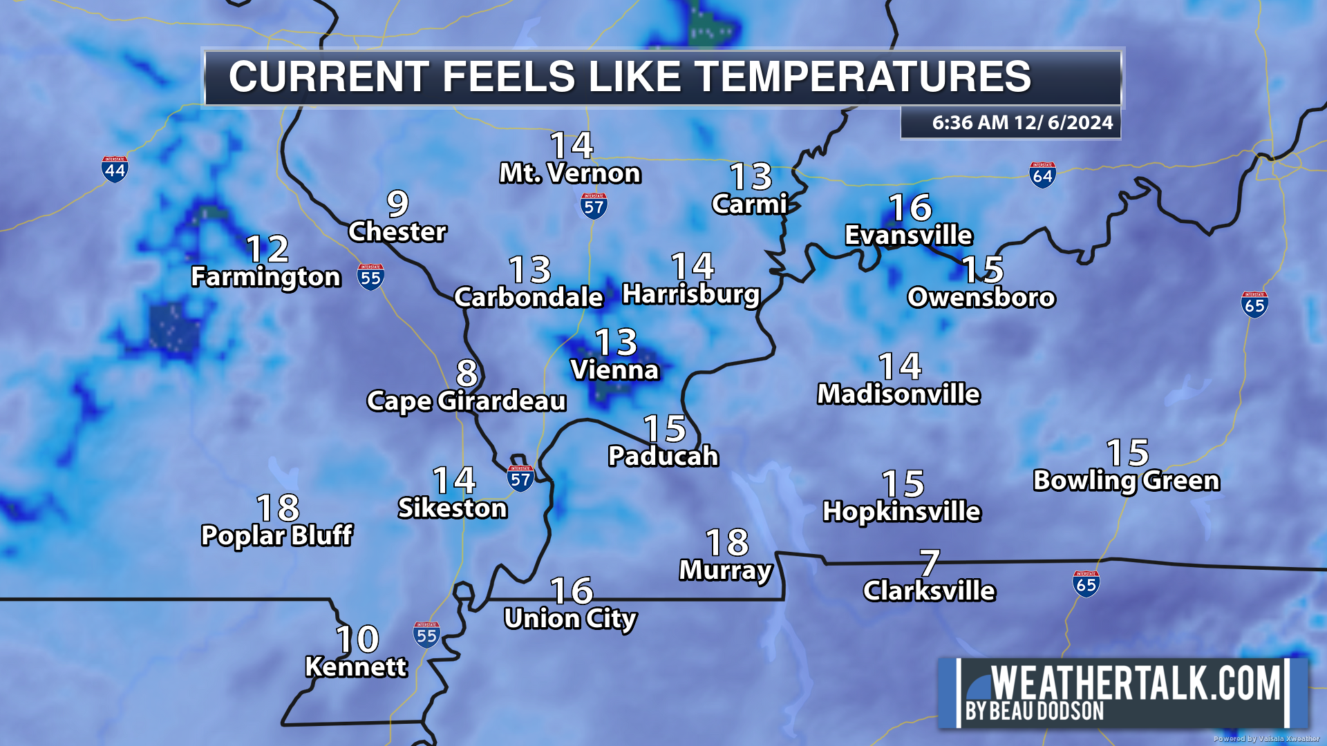
6 AM Wind Chill Temperatures. Double brrr!
It will remain cold today with widespread 30s for highs.
Normal highs for this time of the year are around 50 degrees. We will be well below that today.
The good news is that a warming trend will arrive on Saturday and continue into Monday.
As a matter of fact, some locations could top out near 60 on Monday with southerly winds.
Rain will accompany the warming trend (as is usually the case in autumn and winter).
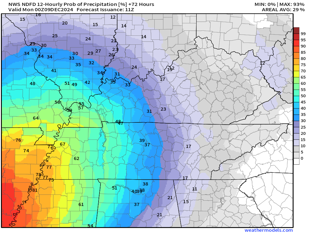
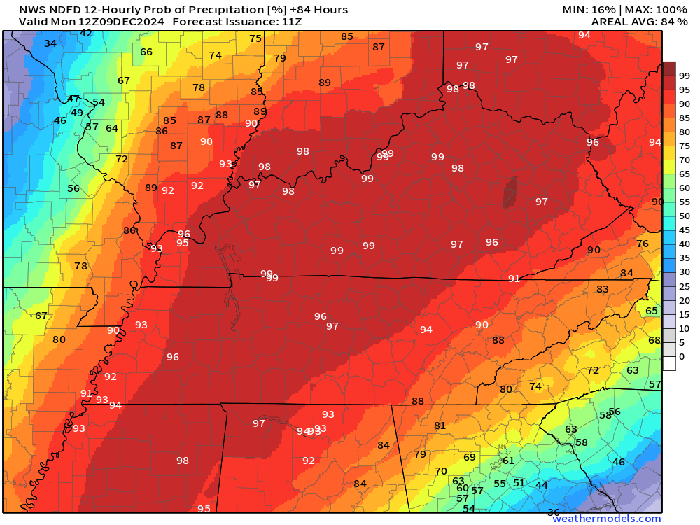
Showers will arrive across the Missouri Bootheel and northwest Tennessee late Sunday morning or afternoon. The rain will then spread north northeast.
See the future-cast radars below.
The system has slowed by about four to eight hours from previous forecasts.
Widespread rain will arrive Sunday night into Monday. I can’t rule out a rumble of thunder, but no severe storms.
Showers will likely linger into Monday and Monday night (esp eastern counties).
Rainfall totals will vary (see below).
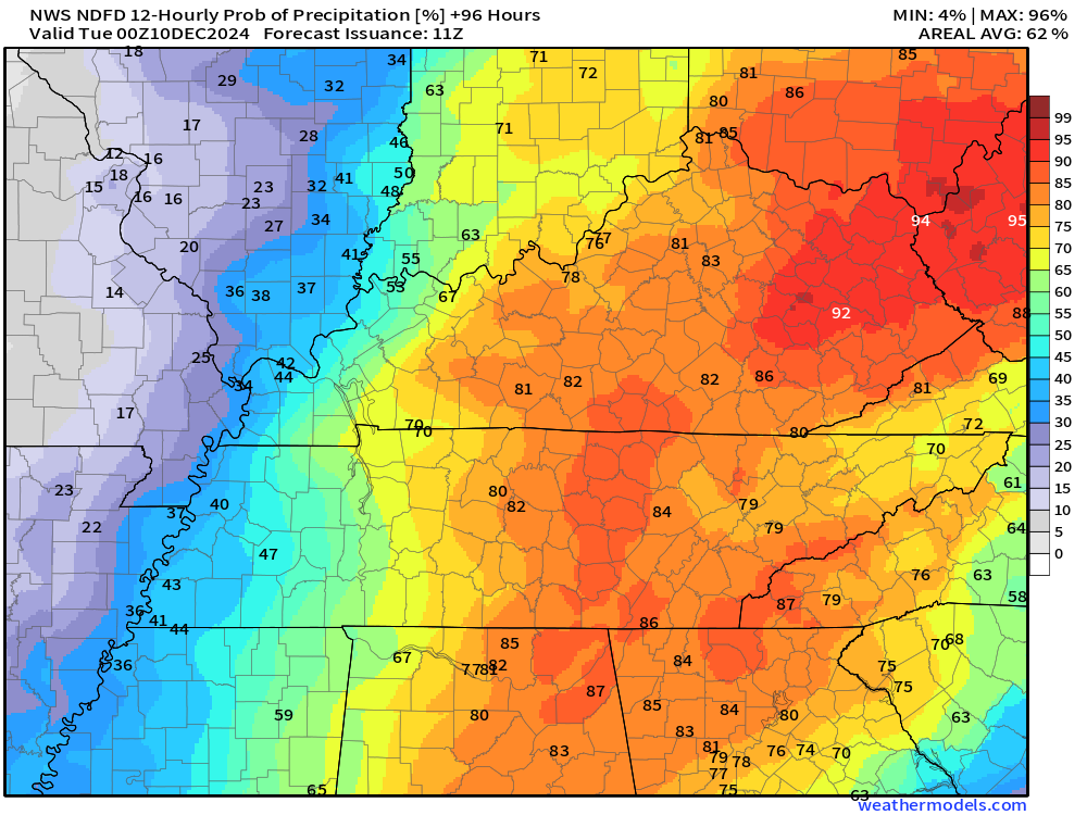
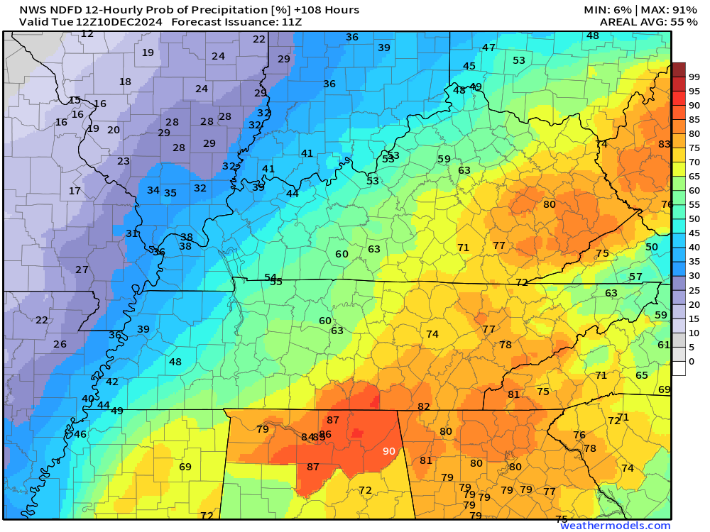
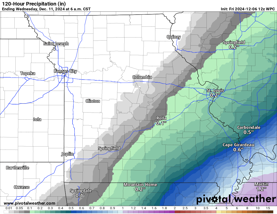
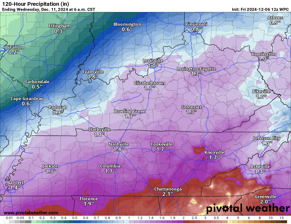
Sunday and Monday Rainfall Totals
Rainfall totals of 0.25″ to 1.25″ are anticipated. Totals have decreased just a bit from previous forecasts.
Our far western and northwestern counties may not receive much rainfall. Especially if the system continues to shift slightly farther east.
Notice the tight gradient. The system has shifted slightly off to the east.
Double click graphics to enlarge them.
Central and eastern view of anticipated rainfall totals.
.
Tuesday and Wednesday of next week.
Occasionally, models show a second system arriving with more precipitation on Tuesday and Wednesday. For now, confidence in that happening is low. It might be too progressive. I will monitor trends in the guidance. They are swinging wildly from run to run.
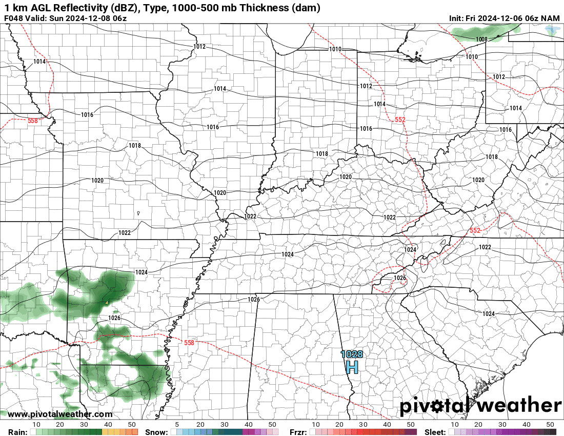
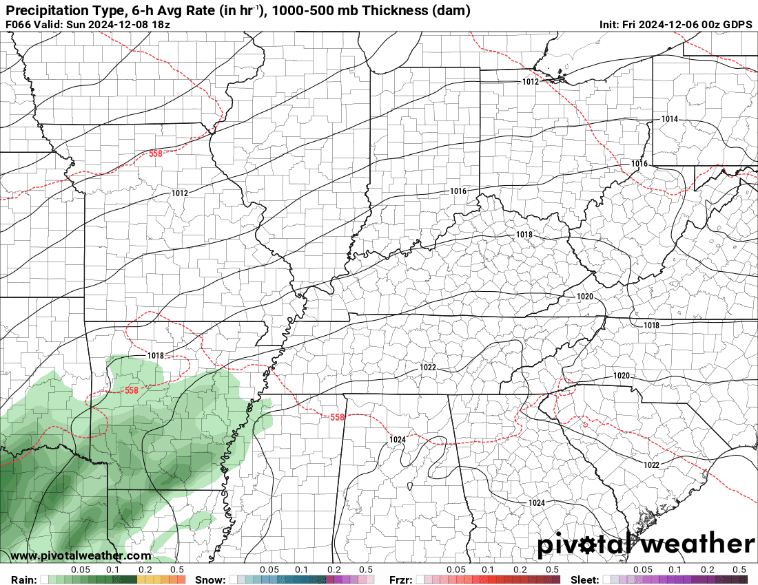
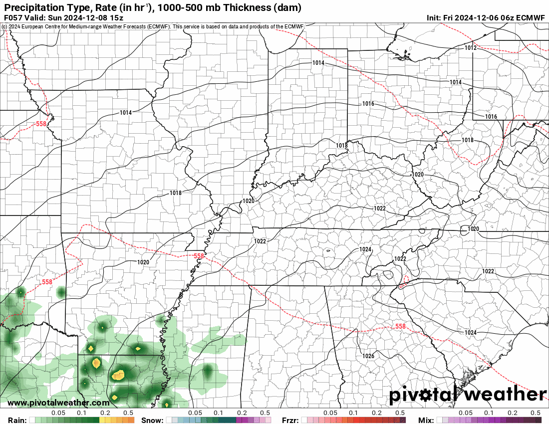
.Let’s look at the future-cast radars. These show the Sunday/Monday rain evebt.

Time stamp is in Zulu. 00z=6 pm. 06z=12 am. 12z=6 am. 18z=12 pm.
The NAM model shows those showers developing throughout today into tonight.
Double click images and animations to enlarge them.
Here is the Canadian model.
.
Time stamp is in Zulu. 00z=6 pm. 06z=12 am. 12z=6 am. 18z=12 pm.
The European EC model shows those showers developing throughout today into tonight.
Double click images and animations to enlarge them.
.
And the American GFS model
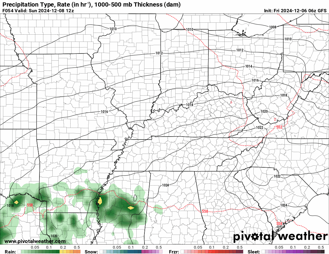
Notice that the GFS model is father east with the Sunday/Monday system. It clips our region. It is the outlier. Let’s see if it corrects past west in today’s runs.
.
![]()
.
Click here if you would like to return to the top of the page.
This outlook covers southeast Missouri, southern Illinois, western Kentucky, and far northwest Tennessee.

.
Today’s Storm Prediction Center’s (SPC) Severe Weather Outlook
Light green is where thunderstorms may occur but should be below severe levels.
Dark green is a level one risk. Yellow is a level two risk. Orange is a level three (enhanced) risk. Red is a level four (moderate) risk. Pink is a level five (high) risk.
One is the lowest risk. Five is the highest risk.
A severe storm is one that produces 58 mph wind or higher, quarter or larger size hail, and/or a tornado.
Explanation of tables. Click here.
Day One Severe Weather Outlook

Day One Severe Weather Outlook. Zoomed in on our region.

.
Day One Tornado Probability Outlook

Day One Regional Tornado Outlook. Zoomed in on our region.

.
Day One Large Hail Probability Outlook

Day One Regional Hail Outlook. Zoomed in on our region.

.
Day One High wind Probability Outlook

Day One Regional Wind Outlook. Zoomed in on our region.

.
Tomorrow’s severe weather outlook. Day two outlook.

Day Two Outlook. Zoomed in on our region.

.
Day Three Severe Weather Outlook

.

.
The images below are from NOAA’s Weather Prediction Center.
24-hour precipitation outlook..
 .
.
.
48-hour precipitation outlook.
. .
.
![]()
..![]()

.
Click here if you would like to return to the top of the page.
.Average high temperatures for this time of the year are around 52 degrees.
Average low temperatures for this time of the year are around 32 degrees.
Average precipitation during this time period ranges from 0.80″ to 1.60″
Six to Ten Day Outlook.
Blue is below average. Red is above average. The no color zone represents equal chances.
Average highs for this time of the year are in the lower 60s. Average lows for this time of the year are in the lower 40s.

Green is above average precipitation. Yellow and brown favors below average precipitation. Average precipitation for this time of the year is around one inch per week.

.

Average low temperatures for this time of the year are around 30 degrees.
Average precipitation during this time period ranges from 0.80″ to 1.60″
.
Eight to Fourteen Day Outlook.
Blue is below average. Red is above average. The no color zone represents equal chances.

Green is above average precipitation. Yellow and brown favors below average precipitation. Average precipitation for this time of the year is around one inch per week.

.
![]()
The app is for subscribers. Subscribe at www.weathertalk.com/welcome then go to your app store and search for WeatherTalk
Subscribers, PLEASE USE THE APP. ATT and Verizon are not reliable during severe weather. They are delaying text messages.
The app is under WeatherTalk in the app store.

Apple users click here

Android users click here
.

Radars and Lightning Data
Interactive-city-view radars. Clickable watches and warnings.
https://wtalk.co/B3XHASFZ
If the radar is not updating then try another one. If a radar does not appear to be refreshing then hit Ctrl F5. You may also try restarting your browser.
Backup radar site in case the above one is not working.
https://weathertalk.com/morani
Regional Radar
https://imagery.weathertalk.com/prx/RadarLoop.mp4
** NEW ** Zoom radar with chaser tracking abilities!
ZoomRadar
Lightning Data (zoom in and out of your local area)
https://wtalk.co/WJ3SN5UZ
Not working? Email me at beaudodson@usawx.com
National map of weather watches and warnings. Click here.
Storm Prediction Center. Click here.
Weather Prediction Center. Click here.
.

Live lightning data: Click here.
Real time lightning data (another one) https://map.blitzortung.org/#5.02/37.95/-86.99
Our new Zoom radar with storm chases
.
.

Interactive GOES R satellite. Track clouds. Click here.
GOES 16 slider tool. Click here.
College of DuPage satellites. Click here
.

Here are the latest local river stage forecast numbers Click Here.
Here are the latest lake stage forecast numbers for Kentucky Lake and Lake Barkley Click Here.
.
.
Find Beau on Facebook! Click the banner.


 .
.