
Click one of the links below to take you directly to that section
.
Seven Day Hazardous Weather Outlook
1. Is lightning in the forecast? NO.
2. Are severe thunderstorms in the forecast? NO.
3. Is flash flooding in the forecast? NO.
4. Will non-thunderstorm winds top 40 mph? NO.
5. Will temperatures drop below 32 degrees? NO.
6. Will the wind chill dip below 10 degrees? NO.
7. Is measurable snow and/or sleet in the forecast? NO.
8. Is freezing rain/ice in the forecast? NO.
Freezing rain is rain that falls and instantly freezes on objects such as trees and power lines Freezing fog possible, as well.
Fire weather risk level.
Friday: 4. Low risk.
Friday night: 4. Low risk.
Saturday: 4. Low risk.
Saturday night: 4. Low risk.
Sunday: 4. Low risk.
Fire Weather Discussion
Minimum relative humidity values will drop into the 30 to 40 percent range today and Saturday. Winds will continue to be light, with afternoon mixing heights in the 3400 to 4200 foot range both days. Dispersion will remain poor due to the light winds.
A Haines Index of 6 means a high potential for an existing fire to become large or exhibit erratic fire behavior, 5 means medium potential, 4 means low potential, and anything less than 4 means very low potential.
.
THE FORECAST IS GOING TO VARY FROM LOCATION TO LOCATION.
Scroll down to see your local forecast details.
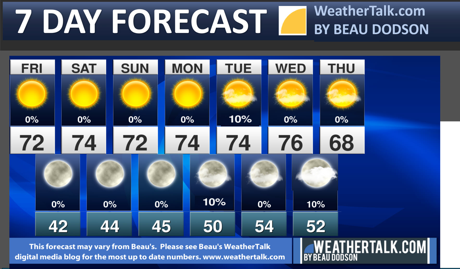
Seven-day forecast for southeast Missouri, southern Illinois, western Kentucky, and western Tennessee.
This is a BLEND for the region. Scroll down to see the region by region forecast.
Seven Day Video
Long Range Video
48-hour forecast Graphics


.
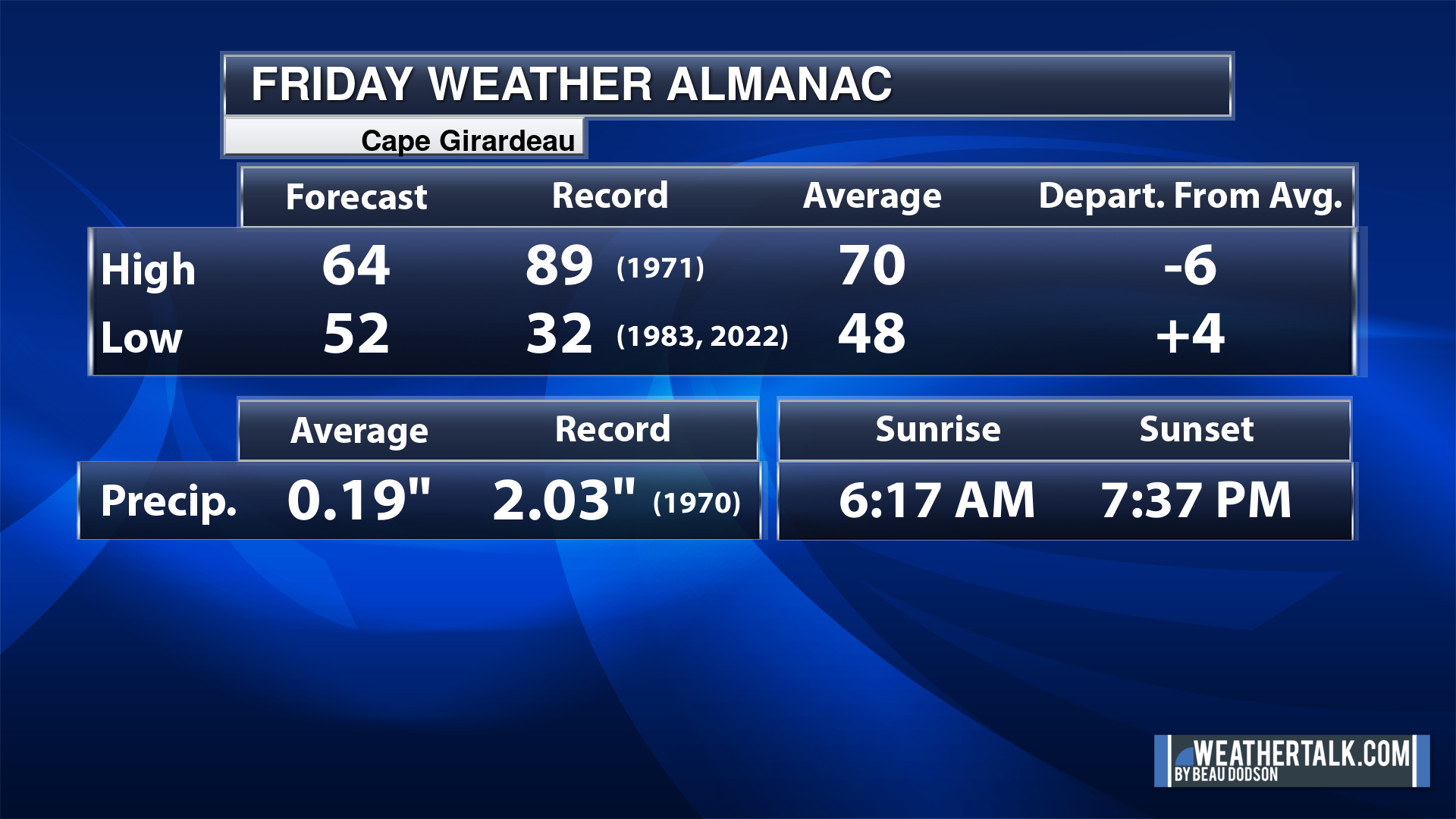
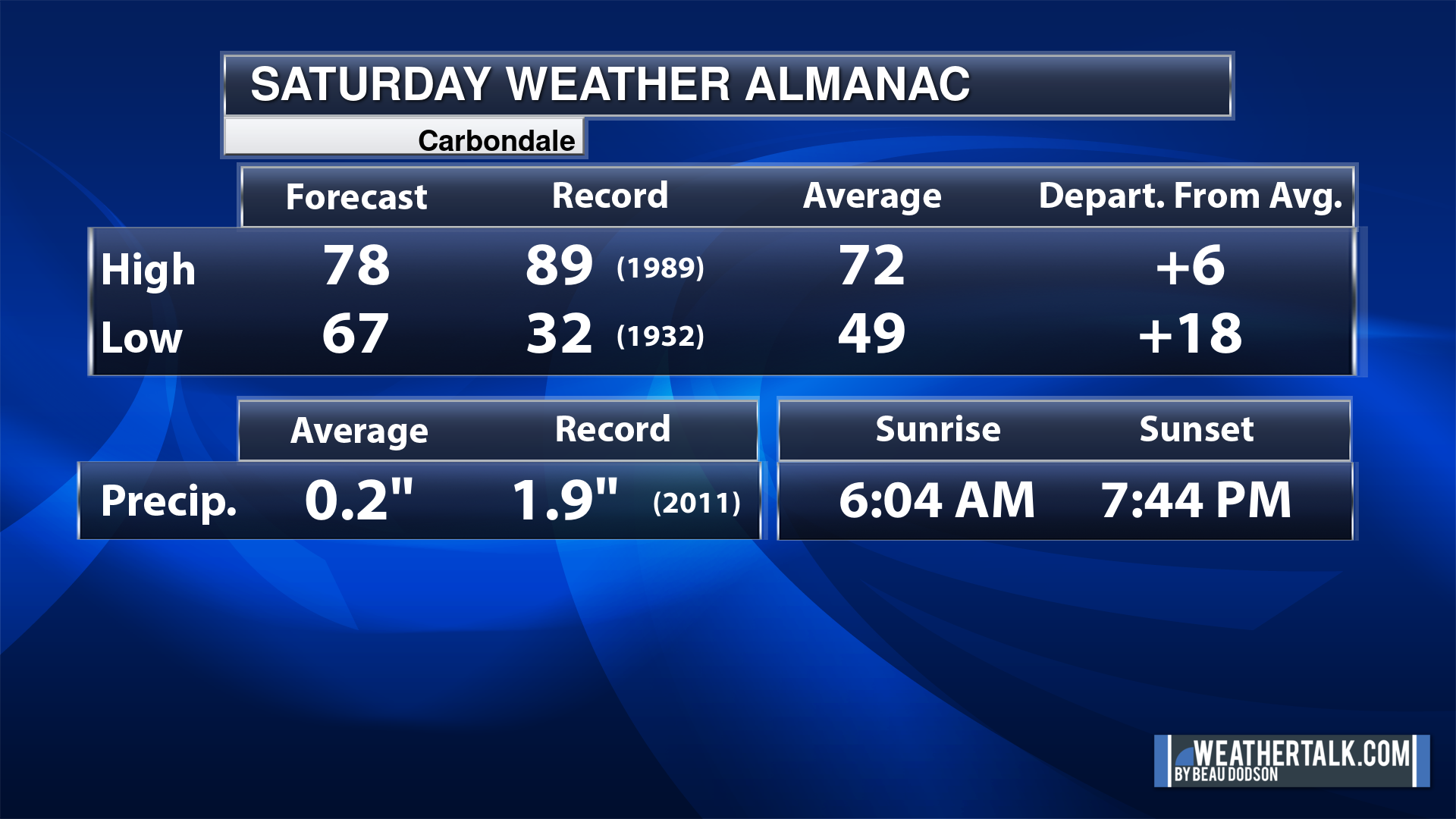
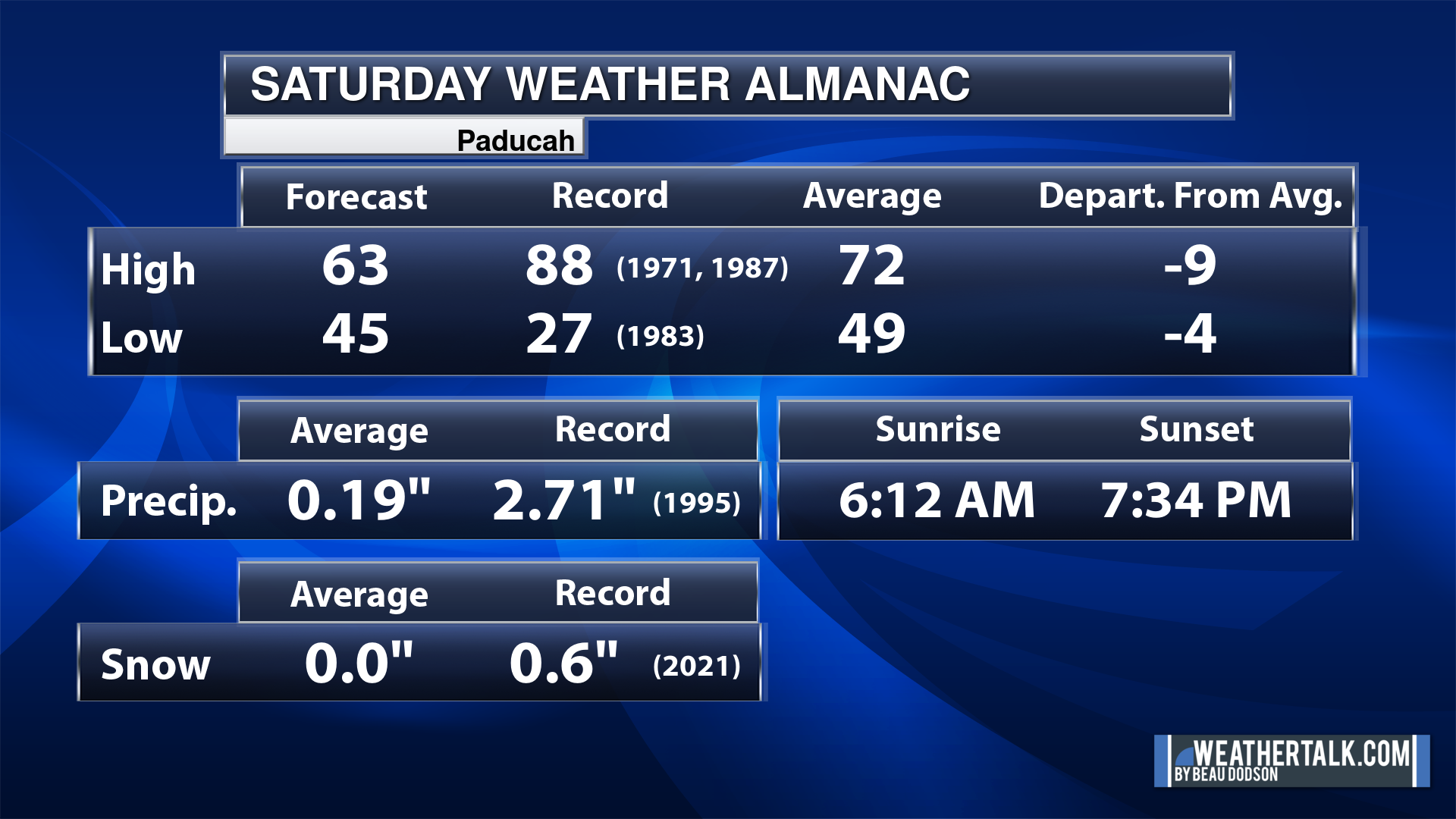
Today’s Local Almanacs (for a few select cities). Your location will be comparable.
Note, the low is this morning’s low and not tomorrows.
The forecast temperature shows you today’s expected high and this morning’s low.
The graphic shows you the record high and record low for today. It shows you what year that occurred, as well.
It then shows you what today’s average temperature is.
It shows you the departures (how may degrees above or below average temperatures will be ).
It shows you the average precipitation for today. Average comes from thirty years of rain totals.
It also shows you the record rainfall for the date and what year that occurred.
The sunrise and sunset are also shown.


.
Friday Forecast: Mostly sunny.
What is the chance of precipitation?
Far northern southeast Missouri ~ 0%
Southeast Missouri ~ 0%
The Missouri Bootheel ~ 0%
I-64 Corridor of southern Illinois ~ 0%
Southern Illinois ~ 0%
Extreme southern Illinois (southern seven counties) ~ 0%
Far western Kentucky (Purchase area) ~ 0%
The Pennyrile area of western KY ~ 0%
Northwest Kentucky (near Indiana border) ~ 0%
Northwest Tennessee ~ 0%
Coverage of precipitation:
Timing of the precipitation:
Temperature range:
Far northern southeast Missouri ~ 68° to 70°
Southeast Missouri ~ 68° to 70°
The Missouri Bootheel ~ 68° to 70°
I-64 Corridor of southern Illinois ~ 68° to 70°
Southern Illinois ~ 68° to 70°
Extreme southern Illinois (southern seven counties) ~ 68° to 70°
Far western Kentucky ~ 68° to 70°
The Pennyrile area of western KY ~ 68° to 70°
Northwest Kentucky (near Indiana border) ~ 68° to 70°
Northwest Tennessee ~ 68° to 70°
Winds will be from this direction: South at 5 mph.
Wind chill or heat index (feels like) temperature forecast: 68° to 70°
What impacts are anticipated from the weather?
Should I cancel my outdoor plans? No
UV Index: 5. Moderate.
Sunrise: 7:07 AM
Sunset: 6:14 PM
.
Friday Night Forecast: Mostly clear.
What is the chance of precipitation?
Far northern southeast Missouri ~ 0%
Southeast Missouri ~ 0%
The Missouri Bootheel ~ 0%
I-64 Corridor of southern Illinois ~ 0%
Southern Illinois ~ 0%
Extreme southern Illinois (southern seven counties) ~ 0%
Far western Kentucky (Purchase area) ~ 0%
The Pennyrile area of western KY ~ 0%
Northwest Kentucky (near Indiana border) ~ 0%
Northwest Tennessee ~ 0%
Coverage of precipitation:
Timing of the precipitation:
Temperature range:
Far northern southeast Missouri ~ 38° to 42°
Southeast Missouri ~ 40° to 42°
The Missouri Bootheel ~ 40° to 44°
I-64 Corridor of southern Illinois ~ 38° to 42°
Southern Illinois ~ 40° to 42°
Extreme southern Illinois (southern seven counties) ~ 40° to 42°
Far western Kentucky ~ 40° to 42°
The Pennyrile area of western KY ~ 40° to 44°
Northwest Kentucky (near Indiana border) ~ 40° to 42°
Northwest Tennessee ~ 40° to 44°
Winds will be from this direction: South 5 to 10 mph.
Wind chill or heat index (feels like) temperature forecast: 38° to 44°
What impacts are anticipated from the weather?
Should I cancel my outdoor plans? No.
Moonrise: 6:54 PM
Moonset: 8:32 AM
The phase of the moon: Waning Gibbous
.
Saturday Forecast: Mostly sunny.
What is the chance of precipitation?
Far northern southeast Missouri ~ 0%
Southeast Missouri ~ 0%
The Missouri Bootheel ~ 0%
I-64 Corridor of southern Illinois ~ 0%
Southern Illinois ~ 0%
Extreme southern Illinois (southern seven counties) ~ 0%
Far western Kentucky (Purchase area) ~ 0%
The Pennyrile area of western KY ~ 0%
Northwest Kentucky (near Indiana border) ~ 0%
Northwest Tennessee ~ 0%
Coverage of precipitation:
Timing of the precipitation:
Temperature range:
Far northern southeast Missouri ~ 70° to 75°
Southeast Missouri ~ 70° to 75°
The Missouri Bootheel ~ 70° to 75°
I-64 Corridor of southern Illinois ~ 70° to 75°
Southern Illinois ~ 70° to 75°
Extreme southern Illinois (southern seven counties) ~ 70° to 75°
Far western Kentucky ~ 70° to 75°
The Pennyrile area of western KY ~ 70° to 75°
Northwest Kentucky (near Indiana border) ~ 70° to 75°
Northwest Tennessee ~ 70° to 75°
Winds will be from this direction: South 4 to 8 mph.
Wind chill or heat index (feels like) temperature forecast: 70° to 75°
What impacts are anticipated from the weather?
Should I cancel my outdoor plans? No
UV Index: 5. Moderate.
Sunrise: 7:07 AM
Sunset: 6:12 PM
.
Saturday Night Forecast: Mostly clear.
What is the chance of precipitation?
Far northern southeast Missouri ~ 0%
Southeast Missouri ~ 0%
The Missouri Bootheel ~ 0%
I-64 Corridor of southern Illinois ~ 0%
Southern Illinois ~ 0%
Extreme southern Illinois (southern seven counties) ~ 0%
Far western Kentucky (Purchase area) ~ 0%
The Pennyrile area of western KY ~ 0%
Northwest Kentucky (near Indiana border) ~ 0%
Northwest Tennessee ~ 0%
Coverage of precipitation:
Timing of the precipitation:
Temperature range:
Far northern southeast Missouri ~ 42° to 45°
Southeast Missouri ~ 40° to 44°
The Missouri Bootheel ~ 42° to 44°
I-64 Corridor of southern Illinois ~ 42° to 44°
Southern Illinois ~ 40° to 44°
Extreme southern Illinois (southern seven counties) ~ 40° to 44°
Far western Kentucky ~ 42° to 44°
The Pennyrile area of western KY ~ 42° to 44°
Northwest Kentucky (near Indiana border) ~ 40° to 44°
Northwest Tennessee ~ 42° to 44°
Winds will be from this direction: South 5 to 10 mph.
Wind chill or heat index (feels like) temperature forecast: 40° to 44°
What impacts are anticipated from the weather?
Should I cancel my outdoor plans? No.
Moonrise: 7:35 PM
Moonset: 9:51 AM
The phase of the moon: Waning Gibbous
.
Sunday Forecast: Mostly sunny.
What is the chance of precipitation?
Far northern southeast Missouri ~ 0%
Southeast Missouri ~ 0%
The Missouri Bootheel ~ 0%
I-64 Corridor of southern Illinois ~ 0%
Southern Illinois ~ 0%
Extreme southern Illinois (southern seven counties) ~ 0%
Far western Kentucky (Purchase area) ~ 0%
The Pennyrile area of western KY ~ 0%
Northwest Kentucky (near Indiana border) ~ 0%
Northwest Tennessee ~ 0%
Coverage of precipitation:
Timing of the precipitation:
Temperature range:
Far northern southeast Missouri ~ 73° to 76°
Southeast Missouri ~ 73° to 76°
The Missouri Bootheel ~ 73° to 76°
I-64 Corridor of southern Illinois ~ 73° to 76°
Southern Illinois ~ 73° to 76°
Extreme southern Illinois (southern seven counties) ~ 73° to 76°
Far western Kentucky ~ 73° to 76°
The Pennyrile area of western KY ~ 73° to 76°
Northwest Kentucky (near Indiana border) ~ 73° to 76°
Northwest Tennessee ~ 73° to 76°
Winds will be from this direction: South 5 to 10 mph.
Wind chill or heat index (feels like) temperature forecast: 73° to 76°
What impacts are anticipated from the weather?
Should I cancel my outdoor plans? No
UV Index: 5. Moderate.
Sunrise: 7:08 AM
Sunset: 6:11 PM
.
Sunday Night Forecast: Mostly clear.
What is the chance of precipitation?
Far northern southeast Missouri ~ 0%
Southeast Missouri ~ 0%
The Missouri Bootheel ~ 0%
I-64 Corridor of southern Illinois ~ 0%
Southern Illinois ~ 0%
Extreme southern Illinois (southern seven counties) ~ 0%
Far western Kentucky (Purchase area) ~ 0%
The Pennyrile area of western KY ~ 0%
Northwest Kentucky (near Indiana border) ~ 0%
Northwest Tennessee ~ 0%
Coverage of precipitation:
Timing of the precipitation:
Temperature range:
Far northern southeast Missouri ~ 44° to 46°
Southeast Missouri ~ 44° to 46°
The Missouri Bootheel ~ 44° to 46°
I-64 Corridor of southern Illinois ~ 44° to 46°
Southern Illinois ~ 44° to 46°
Extreme southern Illinois (southern seven counties) ~ 44° to 46°
Far western Kentucky ~ 44° to 46°
The Pennyrile area of western KY ~ 44° to 46°
Northwest Kentucky (near Indiana border) ~ 44° to 46°
Northwest Tennessee ~ 44° to 46°
Winds will be from this direction: South 5 to 10 mph.
Wind chill or heat index (feels like) temperature forecast: 44° to 46°
What impacts are anticipated from the weather?
Should I cancel my outdoor plans? No.
Moonrise: 8:25 PM
Moonset: 11:07 AM
The phase of the moon: Waning Gibbous
.
Monday Forecast: Mostly sunny.
What is the chance of precipitation?
Far northern southeast Missouri ~ 0%
Southeast Missouri ~ 0%
The Missouri Bootheel ~ 0%
I-64 Corridor of southern Illinois ~ 0%
Southern Illinois ~ 0%
Extreme southern Illinois (southern seven counties) ~ 0%
Far western Kentucky (Purchase area) ~ 0%
The Pennyrile area of western KY ~ 0%
Northwest Kentucky (near Indiana border) ~ 0%
Northwest Tennessee ~ 0%
Coverage of precipitation:
Timing of the precipitation:
Temperature range:
Far northern southeast Missouri ~ 73° to 76°
Southeast Missouri ~ 73° to 76°
The Missouri Bootheel ~ 73° to 76°
I-64 Corridor of southern Illinois ~ 73° to 76°
Southern Illinois ~ 73° to 76°
Extreme southern Illinois (southern seven counties) ~ 73° to 76°
Far western Kentucky ~ 73° to 76°
The Pennyrile area of western KY ~ 73° to 76°
Northwest Kentucky (near Indiana border) ~ 73° to 76°
Northwest Tennessee ~ 73° to 76°
Winds will be from this direction: South southeast 5 to 10 mph.
Wind chill or heat index (feels like) temperature forecast: 73° to 76°
What impacts are anticipated from the weather?
Should I cancel my outdoor plans? No
UV Index: 5. Moderate.
Sunrise: 7:09 AM
Sunset: 6:10 PM
.
Monday Night Forecast: Becoming partly cloudy. A slight chance of light rain (north)
What is the chance of precipitation?
Far northern southeast Missouri ~ 10%
Southeast Missouri ~ 10%
The Missouri Bootheel ~ 0%
I-64 Corridor of southern Illinois ~ 10%
Southern Illinois ~ 10%
Extreme southern Illinois (southern seven counties) ~ 0%
Far western Kentucky (Purchase area) ~ 0%
The Pennyrile area of western KY ~ 0%
Northwest Kentucky (near Indiana border) ~ 10%
Northwest Tennessee ~ 0%
Coverage of precipitation: None to isolated
Timing of the precipitation: After midnight
Temperature range:
Far northern southeast Missouri ~ 48° to 52°
Southeast Missouri ~ 48° to 52°
The Missouri Bootheel ~ 48° to 52°
I-64 Corridor of southern Illinois ~ 48° to 52°
Southern Illinois ~ 48° to 52°
Extreme southern Illinois (southern seven counties) ~ 48° to 52°
Far western Kentucky ~ 48° to 52°
The Pennyrile area of western KY ~ 48° to 52°
Northwest Kentucky (near Indiana border) ~ 48° to 52°
Northwest Tennessee ~ 48° to 52°
Winds will be from this direction: South southeast 5 to 10 mph.
Wind chill or heat index (feels like) temperature forecast: 48° to 52°
What impacts are anticipated from the weather?
Should I cancel my outdoor plans? No.
Moonrise: 9:22 PM
Moonset: 12:16 PM
The phase of the moon: Waning Gibbous
.
Tuesday Forecast: Some morning clouds. Becoming mostly sunny. A slight chance of morning showers (north)
What is the chance of precipitation?
Far northern southeast Missouri ~ 10%
Southeast Missouri ~ 10%
The Missouri Bootheel ~ 0%
I-64 Corridor of southern Illinois ~ 10%
Southern Illinois ~ 10%
Extreme southern Illinois (southern seven counties) ~ 0%
Far western Kentucky (Purchase area) ~ 0%
The Pennyrile area of western KY ~ 0%
Northwest Kentucky (near Indiana border) ~ 10%
Northwest Tennessee ~ 0%
Coverage of precipitation: None to isolated
Timing of the precipitation: Before noon
Temperature range:
Far northern southeast Missouri ~ 74° to 76°
Southeast Missouri ~ 74° to 76°
The Missouri Bootheel ~ 74° to 76°
I-64 Corridor of southern Illinois ~ 74° to 76°
Southern Illinois ~ 74° to 76°
Extreme southern Illinois (southern seven counties) ~ 74° to 76°
Far western Kentucky ~ 74° to 76°
The Pennyrile area of western KY ~ 74° to 76°
Northwest Kentucky (near Indiana border) ~ 74° to 76°
Northwest Tennessee ~ 74° to 76°
Winds will be from this direction: South southeast 6 to 12 mph.
Wind chill or heat index (feels like) temperature forecast: 74° to 76°
What impacts are anticipated from the weather?
Should I cancel my outdoor plans? No
UV Index: 5. Moderate.
Sunrise: 7:10 AM
Sunset: 6:08 PM
.
Tuesday Night Forecast: Mostly clear.
What is the chance of precipitation?
Far northern southeast Missouri ~ 0%
Southeast Missouri ~ 0%
The Missouri Bootheel ~ 0%
I-64 Corridor of southern Illinois ~ 0%
Southern Illinois ~ 0%
Extreme southern Illinois (southern seven counties) ~ 0%
Far western Kentucky (Purchase area) ~ 0%
The Pennyrile area of western KY ~ 0%
Northwest Kentucky (near Indiana border) ~ 0%
Northwest Tennessee ~ 0%
Coverage of precipitation:
Timing of the precipitation:
Temperature range:
Far northern southeast Missouri ~ 50° to 54°
Southeast Missouri ~ 50° to 54°
The Missouri Bootheel ~ 50° to 54°
I-64 Corridor of southern Illinois ~ 50° to 54°
Southern Illinois ~ 50° to 54°
Extreme southern Illinois (southern seven counties) ~ 50° to 54°
Far western Kentucky ~50° to 54°
The Pennyrile area of western KY ~ 50° to 54°
Northwest Kentucky (near Indiana border) ~ 50° to 54°
Northwest Tennessee ~ 50° to 54°
Winds will be from this direction: west southwest 5 to 10 mph.
Wind chill or heat index (feels like) temperature forecast: 50° to 54°
What impacts are anticipated from the weather?
Should I cancel my outdoor plans? No.
Moonrise: 10:26 PM
Moonset: 1:14 PM
The phase of the moon: Waning Gibbous
.
Wednesday Forecast: Mostly sunny. Some afternoon clouds are possible.
What is the chance of precipitation?
Far northern southeast Missouri ~ 0%
Southeast Missouri ~ 0%
The Missouri Bootheel ~ 0%
I-64 Corridor of southern Illinois ~ 0%
Southern Illinois ~ 0%
Extreme southern Illinois (southern seven counties) ~ 0%
Far western Kentucky (Purchase area) ~ 0%
The Pennyrile area of western KY ~ 0%
Northwest Kentucky (near Indiana border) ~ 0%
Northwest Tennessee ~ 0%
Coverage of precipitation:
Timing of the precipitation:
Temperature range:
Far northern southeast Missouri ~ 75° to 80°
Southeast Missouri ~ 75° to 80°
The Missouri Bootheel ~ 75° to 80°
I-64 Corridor of southern Illinois ~ 75° to 80°
Southern Illinois ~ 75° to 80°
Extreme southern Illinois (southern seven counties) ~ 75° to 80°
Far western Kentucky ~ 75° to 80°
The Pennyrile area of western KY ~ 75° to 80°
Northwest Kentucky (near Indiana border) ~ 75° to 80°
Northwest Tennessee ~ 75° to 80°
Winds will be from this direction: West southwest 6 to 12 mph. Gusts to 15 mph.
Wind chill or heat index (feels like) temperature forecast: 75° to 80°
What impacts are anticipated from the weather?
Should I cancel my outdoor plans? No
UV Index: 4. Moderate.
Sunrise: 7:11 AM
Sunset: 6:07 PM
.
Wednesday Night Forecast: Partly cloudy.
What is the chance of precipitation?
Far northern southeast Missouri ~ 0%
Southeast Missouri ~ 0%
The Missouri Bootheel ~ 0%
I-64 Corridor of southern Illinois ~ 0%
Southern Illinois ~ 0%
Extreme southern Illinois (southern seven counties) ~ 0%
Far western Kentucky (Purchase area) ~ 0%
The Pennyrile area of western KY ~ 0%
Northwest Kentucky (near Indiana border) ~ 0%
Northwest Tennessee ~ 0%
Coverage of precipitation:
Timing of the precipitation:
Temperature range:
Far northern southeast Missouri ~ 45° to 50°
Southeast Missouri ~ 45° to 50°
The Missouri Bootheel ~ 45° to 50°
I-64 Corridor of southern Illinois ~ 45° to 50°
Southern Illinois ~ 45° to 50°
Extreme southern Illinois (southern seven counties) ~ 45° to 50°
Far western Kentucky ~45° to 50°
The Pennyrile area of western KY ~ 45° to 50°
Northwest Kentucky (near Indiana border) ~ 45° to 50°
Northwest Tennessee ~ 45° to 50°
Winds will be from this direction: North northwest 6 to 12 mph. Gusts to 15 mph.
Wind chill or heat index (feels like) temperature forecast: 45° to 50°
What impacts are anticipated from the weather?
Should I cancel my outdoor plans? No.
Moonrise: 11:32 PM
Moonset: 2:01 PM
The phase of the moon: Waning Gibbous
.
Thursday Forecast: Mostly sunny.
What is the chance of precipitation?
Far northern southeast Missouri ~ 0%
Southeast Missouri ~ 0%
The Missouri Bootheel ~ 0%
I-64 Corridor of southern Illinois ~ 0%
Southern Illinois ~ 0%
Extreme southern Illinois (southern seven counties) ~ 0%
Far western Kentucky (Purchase area) ~ 0%
The Pennyrile area of western KY ~ 0%
Northwest Kentucky (near Indiana border) ~ 0%
Northwest Tennessee ~ 0%
Coverage of precipitation:
Timing of the precipitation:
Temperature range:
Far northern southeast Missouri ~ 64° to 68°
Southeast Missouri ~ 64° to 68°
The Missouri Bootheel ~ 64° to 68°
I-64 Corridor of southern Illinois ~ 64° to 68°
Southern Illinois ~ 64° to 68°
Extreme southern Illinois (southern seven counties) ~ 64° to 68°
Far western Kentucky ~ 64° to 68°
The Pennyrile area of western KY ~ 64° to 68°
Northwest Kentucky (near Indiana border) ~ 64° to 68°
Northwest Tennessee ~ 64° to 68°
Winds will be from this direction: North 5 to 10 mph
Wind chill or heat index (feels like) temperature forecast: 64° to 68°
What impacts are anticipated from the weather?
Should I cancel my outdoor plans? No
UV Index: 4. Moderate.
Sunrise: 7:12 AM
Sunset: 6:06 PM
.
Thursday Night Forecast: Mostly clear.
What is the chance of precipitation?
Far northern southeast Missouri ~ 0%
Southeast Missouri ~ 0%
The Missouri Bootheel ~ 0%
I-64 Corridor of southern Illinois ~ 0%
Southern Illinois ~ 0%
Extreme southern Illinois (southern seven counties) ~ 0%
Far western Kentucky (Purchase area) ~ 0%
The Pennyrile area of western KY ~ 0%
Northwest Kentucky (near Indiana border) ~ 0%
Northwest Tennessee ~ 0%
Coverage of precipitation:
Timing of the precipitation:
Temperature range:
Far northern southeast Missouri ~ 38° to 42°
Southeast Missouri ~ 38° to 42°
The Missouri Bootheel ~ 38° to 42°
I-64 Corridor of southern Illinois ~ 38° to 42°
Southern Illinois ~ 38° to 42°
Extreme southern Illinois (southern seven counties) ~ 38° to 42°
Far western Kentucky ~ 38° to 42°
The Pennyrile area of western KY ~ 38° to 42°
Northwest Kentucky (near Indiana border) ~ 38° to 42°
Northwest Tennessee ~ 38° to 42°
Winds will be from this direction: North 5 to 10 mph
Wind chill or heat index (feels like) temperature forecast: 38° to 42°
What impacts are anticipated from the weather?
Should I cancel my outdoor plans? No.
Moonrise: —–
Moonset: 2:39 PM
The phase of the moon: Last Quarter
.
Click here if you would like to return to the top of the page.
-
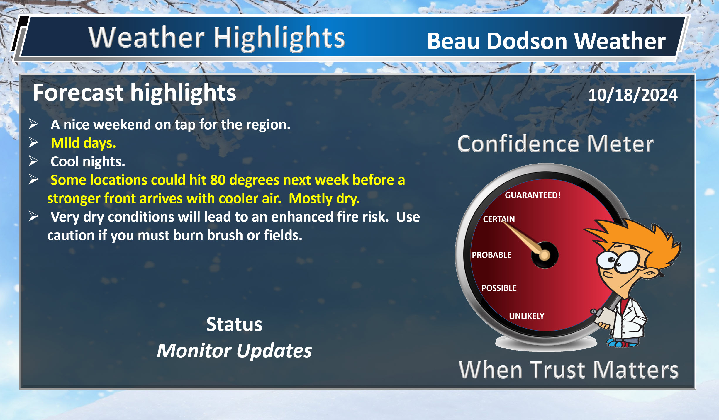
- Mild days. Cool nights.
- Weak disturbance Monday and Tuesday. Slight chance of rain.
- Some locations could hit 80 next week.
- Another mostly dry or dry cold front Wednesday night.
- Use care if you are burning brush, leaves, or fields.
Weather advice:
Do you have any suggestions or comments? Email me at beaudodson@usawx.com
Make sure you have three to five ways of receiving your severe weather information.
Weather Talk is one of those ways.
.
Beau’s Forecast Discussion
The weather pattern will remain calm through at least Monday.
More dry weather. It remains quite dry across the region. The last time we had measurable rain was in late September. Flash drought is developing, again.
If you must burn fields or brush, then use care. Use care with combines, as well.
A warming trend will begin Friday and last into next week. Widespread seventies return. It will also be dry into early next week. No significant weather to monitor.
A weak system will pass through the region Monday and Tuesday. That should bring an increase in clouds. Maybe isolated light showers. For now, I left the forecast dry. I will monitor it.
Much of next week looks calm, as well.
I can’t rule out some 80s next week. Warm, again.
I keep watching the end of the month for one or two stronger storm systems. Perhaps showers and thunderstorms. For now, that is in the long long range and confidence is low.
Don’t forget, our second severe weather season is approaching. Typically, late October into November produce systems with severe weather. That does include tornadoes. Our deadliest tornadoes tend to be in the autumn and winter.
Stay weather-wise.
The myth of winter forecasting.
Quite a few of you have been asking me about the upcoming winter.
I always give you my honest opinion. Each year, I repeat what is written below.
Some of this is borrowed from the late great John Dee from Wisconsin.
First off, I want to say that I do have friends in the weather community that enjoy posting a winter forecast. Mostly for fun and entertainment purposes. This is nothing against them.
You can already find winter forecasts online. That includes the Farmers Almanac (which has been proven to be inaccurate).
Despite assertions the almanacs are 80-85% accurate, studies have shown their long-range predictions are sometimes little better than a coin flip. One study cited by Popular Mechanics reported the Farmer’s Almanac was right about 52% of the time.
In other words, your guess is as good as theirs. Flip a coin.
Dick Frymire’s winter forecast is another one that usually makes its rounds.
When I was a child, my grandmother would cut his forecast out of the Paducah Sun. We would hang it on the refrigerator. It was always a snowy forecast. It was rarely correct. It was for fun and entertainment.
I want to clarify the distinction between seasonal forecasting and short-term weather forecasting. All weather predictions involve some degree of uncertainty. For forecasts covering the next 24 to 48 hours, you might rely on 90% scientific methods and 10% guesswork. However, for forecasts extending to days 7, 8, 9, or 10, that ratio shifts to about 50% science and 50% guess. When it comes to seasonal forecasting, the scientific basis is much weaker, often resembling creative writing dressed up with meteorological jargon.
In other words, take the winter outlooks with a grain of salt. They are fun and entertaining to read. But, they don’t offer up much more value than that.
Key point.
We can NOT accurately forecast what you really want to know. Will there be big snowstorms? Will there be big ice storms? Will there be major river flooding? Will there be tornado outbreaks?
It is not meteorologically possible to forecast SPECIFIC events weeks and months from now.
Let me repeat that! It is not meteorologically possible to forecast specific events weeks and months from now.
On October 17th, if someone tells you there will be four inches of snow on January 15th, then they are throwing darts and guessing. There is no skill involved in that forecast.
We do not have the capability to forecast specific events that far out. I wish we could, but we can’t.
If is the same with some computer AI driven weather apps that show you a day twenty forecast. It is impossible to forecast specifics that far out.
So what can we forecast?
With that said, one significant factor influencing seasonal weather patterns in the U.S. is El Niño, the phenomenon of warmer-than-average surface waters in the central and eastern Pacific Ocean. El Niño is linked to various weather anomalies worldwide, sometimes unjustly blamed for certain conditions. In recent years, many snow enthusiasts have come to view El Niño unfavorably, as it’s often associated with poor snowfall in the Midwest. However, scientists are learning that each El Niño event has unique characteristics, and they can have varying impacts based on their strength.
Historically, it was widely believed that El Niño leads to warmer temperatures across our region. Drier, as well. However, recent observations suggest that weak El Niños can actually bring below-average temperatures to much of the eastern U.S., including many Midwest areas. For example, during the winter of 2003-2004, weak El Niño conditions resulted in a colder and snowier January and February for the Midwest.
On the flip side, strong El Niños typically correlate with above-average temperatures and below-average snowfall in our region., with stronger events often leading to more pronounced impacts.
El Niño’s counterpart, La Niña, also brings its own weather anomalies.
We are expecting this winter to be a La Nina winter.
Weak La Niñas can lead to near to below-average temperatures across the midwest, while stronger La Niñas tend to diminish this effect. Interestingly, strong La Niñas can produce warmer conditions in the southern Midwest, but these anomalies rarely extend far north.
La Nina’s can lead to above average precipitation in the Ohio Valley.
La Nina’s typically mean that our region will experience a slightly higher risk of freezing rain and sleet. It means that we will have a slightly higher risk of severe weather/tornadoes.
It does not mean we will have an ice storm or tornado outbreak. It simply means the chances are increased.
Last year was an El Nino winter. The three previous years were La Nina winters.
One simple method we use to predict winter weather involves looking at long-term averages for a region. The longer the timeframe considered, the closer the numbers will trend toward the norm for temperature and precipitation. For example, a single day might show extreme temperature variations or precipitation levels significantly above average. However, when averaging over multiple days, weeks, or even a year, those extremes tend to balance out.
Weather patterns are inherently cyclical—droughts and floods don’t last indefinitely, and temperature extremes will eventually revert to normal. The longer a particular anomaly persists, the more likely it is to reverse.
Another approach we employ examines several past seasons for anomalies and assesses whether there’s been an imbalance in the last 5 to 15 years. For instance, if our region has experienced several winters with below-average snowfall, one could argue there’s a greater likelihood of a more snow-filled winter in the near future unless climate patterns shift significantly. Which, they seem to be.
Those climate changes throw monkey wrenches into seasonal forecasts. Patterns become increasingly chaotic.
So, where does this leave us? First, I hope to emphasize that many seasonal forecasts are largely speculative; your guess may be just as valid as any meteorologist’s. While some statistical patterns might suggest certain weather trends, predicting a season’s outcome with confidence remains elusive.
I do believe the science will eventually evolve and lead to seasonal outlooks becoming more accurate. For now, however, we just aren’t there.
When you ask me if we will have a snowy winter, the honest answer is we don’t know. There is not a way to accurately forecast specifics months in advance.
The best we can do is give you generalities. Will temperatures average above or below normal. Will precipitation average above or below average.
The current outlook for October, November, and December is below average precipitation with near to above average temperatures.
There are signals for several solid cold shots in December.
January and February may deliver above average precipitation. With near average temperatures.
![]()
.
Click here if you would like to return to the top of the page.
This outlook covers southeast Missouri, southern Illinois, western Kentucky, and far northwest Tennessee.
.
Today’s Storm Prediction Center’s (SPC) Severe Weather Outlook
Light green is where thunderstorms may occur but should be below severe levels.
Dark green is a level one risk. Yellow is a level two risk. Orange is a level three (enhanced) risk. Red is a level four (moderate) risk. Pink is a level five (high) risk.
One is the lowest risk. Five is the highest risk.
A severe storm is one that produces 58 mph wind or higher, quarter or larger size hail, and/or a tornado.
Explanation of tables. Click here.
Day One Severe Weather Outlook

Day One Severe Weather Outlook. Zoomed in on our region.

.
Day One Tornado Probability Outlook

Day One Regional Tornado Outlook. Zoomed in on our region.

.
Day One Large Hail Probability Outlook

Day One Regional Hail Outlook. Zoomed in on our region.

.
Day One High wind Probability Outlook

Day One Regional Wind Outlook. Zoomed in on our region.

.
Tomorrow’s severe weather outlook. Day two outlook.

Day Two Outlook. Zoomed in on our region.

.
Day Three Severe Weather Outlook

.

.
The images below are from NOAA’s Weather Prediction Center.
24-hour precipitation outlook..
 .
.
.
48-hour precipitation outlook.
. .
.
![]()
_______________________________________
.

Click here if you would like to return to the top of the page.
Again, as a reminder, these are models. They are never 100% accurate. Take the general idea from them.
What should I take from these?
- The general idea and not specifics. Models usually do well with the generalities.
- The time-stamp is located in the upper left corner.
.
What am I looking at?
You are looking at computer model data. Meteorologists use many different models to forecast the weather.
Occasionally, these maps are in Zulu time. 12z=7 AM. 18z=1 PM. 00z=7 PM. 06z=1 AM
Green represents light rain. Dark green represents moderate rain. Yellow and orange represent heavier rain.
.
This animation is the NAM Model.
This graphic shows you what this particular model believes the radar may look like. Each model may be a little different. The more models that agree, the higher the confidence in the forecast outcome.
Occasionally, these maps are in Zulu time. 12z=7 AM. 18z=1 PM. 00z=7 PM. 06z=1 AM
Double click images to enlarge them.
.
This animation is the Hrrr Model.
This graphic shows you what this particular model believes the radar may look like. Each model may be a little different. The more models that agree, the higher the confidence in the forecast outcome.
Green is rain. Yellow and orange are heavier rain. Pink is a wintry mix. Blue is snow. Dark blue is heavier snow.
Occasionally, these maps are in Zulu time. 12z=7 AM. 18z=1 PM. 00z=7 PM. 06z=1 AM
Double click images to enlarge them.
.
This animation is the WRF Model.
This graphic shows you what this particular model believes the radar may look like. Each model may be a little different. The more models that agree, the higher the confidence in the forecast outcome.
Green is rain. Yellow and orange are heavier rain. Pink is a wintry mix. Blue is snow. Dark blue is heavier snow.
Occasionally, these maps are in Zulu time. 12z=7 AM. 18z=1 PM. 00z=7 PM. 06z=1 AM
Double click images to enlarge them.
.
This animation is the GFS Model.
This graphic shows you what this particular model believes the radar may look like. Each model may be a little different. The more models that agree, the higher the confidence in the forecast outcome.
Green is rain. Yellow and orange are heavier rain. Pink is a wintry mix. Blue is snow. Dark blue is heavier snow.
Occasionally, these maps are in Zulu time. 12z=7 AM. 18z=1 PM. 00z=7 PM. 06z=1 AM
Double click images to enlarge them.
.
This animation is the EC Model.
This graphic shows you what this particular model believes the radar may look like. Each model may be a little different. The more models that agree, the higher the confidence in the forecast outcome.
Green is rain. Yellow and orange are heavier rain. Pink is a wintry mix. Blue is snow. Dark blue is heavier snow.
Occasionally, these maps are in Zulu time. 12z=7 AM. 18z=1 PM. 00z=7 PM. 06z=1 AM
Double click images to enlarge them.
.
..![]()

.
Click here if you would like to return to the top of the page.
.Average high temperatures for this time of the year are around 72 degrees.
Average low temperatures for this time of the year are around 49 degrees.
Average precipitation during this time period ranges from 0.80″ to 1.60″
Six to Ten Day Outlook.
Blue is below average. Red is above average. The no color zone represents equal chances.
Average highs for this time of the year are in the lower 60s. Average lows for this time of the year are in the lower 40s.

Green is above average precipitation. Yellow and brown favors below average precipitation. Average precipitation for this time of the year is around one inch per week.

.

Average low temperatures for this time of the year are around 47 degrees.
Average precipitation during this time period ranges from 0.80″ to 1.60″
.
Eight to Fourteen Day Outlook.
Blue is below average. Red is above average. The no color zone represents equal chances.

Green is above average precipitation. Yellow and brown favors below average precipitation. Average precipitation for this time of the year is around one inch per week.

.
![]()
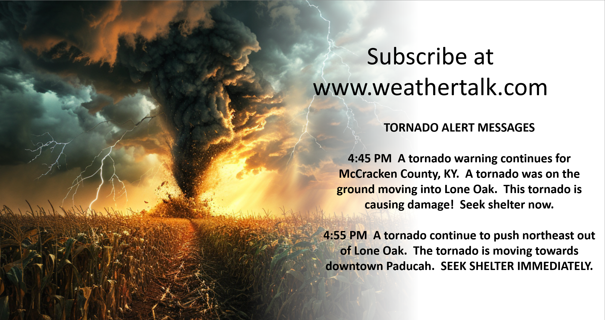
The app is for subscribers. Subscribe at www.weathertalk.com/welcome then go to your app store and search for WeatherTalk
Subscribers, PLEASE USE THE APP. ATT and Verizon are not reliable during severe weather. They are delaying text messages.
The app is under WeatherTalk in the app store.
Apple users click here
Android users click here
.

Radars and Lightning Data
Interactive-city-view radars. Clickable watches and warnings.
https://wtalk.co/B3XHASFZ
If the radar is not updating then try another one. If a radar does not appear to be refreshing then hit Ctrl F5. You may also try restarting your browser.
Backup radar site in case the above one is not working.
https://weathertalk.com/morani
Regional Radar
https://imagery.weathertalk.com/prx/RadarLoop.mp4
** NEW ** Zoom radar with chaser tracking abilities!
ZoomRadar
Lightning Data (zoom in and out of your local area)
https://wtalk.co/WJ3SN5UZ
Not working? Email me at beaudodson@usawx.com
National map of weather watches and warnings. Click here.
Storm Prediction Center. Click here.
Weather Prediction Center. Click here.
.

Live lightning data: Click here.
Real time lightning data (another one) https://map.blitzortung.org/#5.02/37.95/-86.99
Our new Zoom radar with storm chases
.
.

Interactive GOES R satellite. Track clouds. Click here.
GOES 16 slider tool. Click here.
College of DuPage satellites. Click here
.

Here are the latest local river stage forecast numbers Click Here.
Here are the latest lake stage forecast numbers for Kentucky Lake and Lake Barkley Click Here.
.
.
Find Beau on Facebook! Click the banner.







 .
.