Good morning/afternoon, everyone!
Well, we knew summer wasn’t over. The heat has returned.
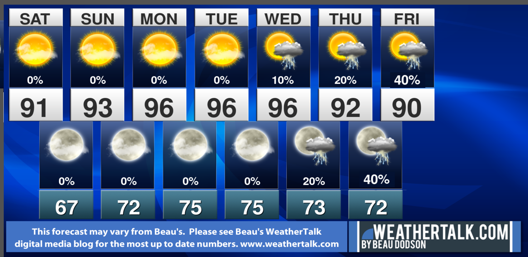
You can expect highs in the low 90s today. A few clouds over southeast Missouri and southwest Illinois.
The heat will intensify over the coming days. You can expect middle 90s Sunday and then middle to upper 90s Monday through Wednesday. Some locations will hit 100 degrees Monday and Tuesday.
The good news, in all of this, is that dew points won’t be all that high. Yes, it will be humid. But, not extreme. Heat index values will likely range from 95 to 100 degrees Sunday and then 100 to 108 degrees Monday and Tuesday. A bit lower Wednesday.
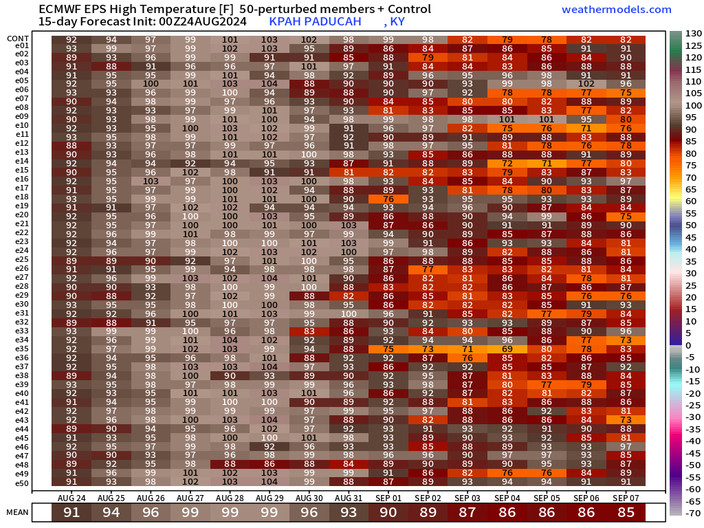
Check out the EC ensemble model heat matrix graphic.
The veridical lines represent one model run. They run the model over 50 times. Then, the bottom number near the calendar date is the average of all the models.
You don’t see a heat matrix like this very often. The EC ensemble members point to some locations hitting 100 degrees Monday and Tuesday of this week. Perhaps the hottest actual air temps of the summer (not the hottest heat index values).
Look in the long range. It will turn cooler by next weekend.
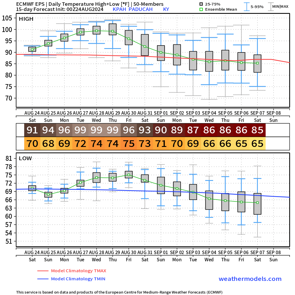
Another view of the EC model ensembles. Showing the high and low temperatures for the coming days.
What is the probability of hitting 100 degrees?
There is a low end chance of a thunderstorm Wednesday.
A cold front pushes into the region Thursday night and Friday. This will bring at least scattered showers and thunderstorms.
The official seven day rainfall forecast does not hold much promise for drought breaking rains.
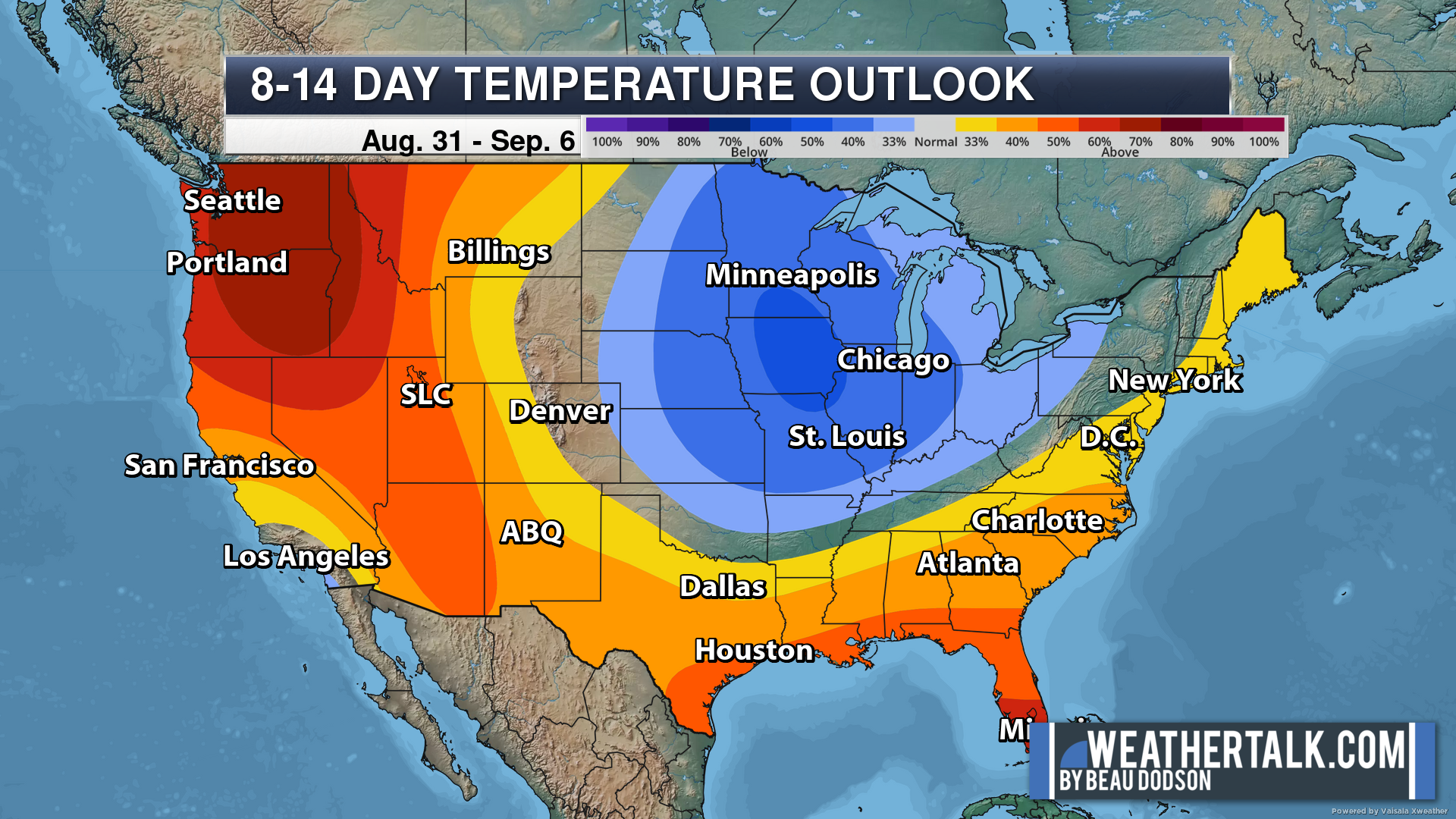
Temperatures will cool down Friday into the following week. Below average readings are possible as we start September.
The blue indicates where below average temperatures are most likely to occur. The dark blue represents higher probabilities of below average temperatures. We will be ready for a cool down by the end of this new work week!
The rain probabilities will likely need adjusting.
48-hour forecast Graphics


.
Click here if you would like to return to the top of the page.
.Average high temperatures for this time of the year are around 90 degrees.
Average low temperatures for this time of the year are around 70 degrees.
Average precipitation during this time period ranges from 0.80″ to 1.60″
Six to Ten Day Outlook.
Blue is below average. Red is above average. The no color zone represents equal chances.
Average highs for this time of the year are in the lower 60s. Average lows for this time of the year are in the lower 40s.

Green is above average precipitation. Yellow and brown favors below average precipitation. Average precipitation for this time of the year is around one inch per week.

.

Average low temperatures for this time of the year are around 68 degrees.
Average precipitation during this time period ranges from 0.80″ to 1.60″
.
Eight to Fourteen Day Outlook.
Blue is below average. Red is above average. The no color zone represents equal chances.

Green is above average precipitation. Yellow and brown favors below average precipitation. Average precipitation for this time of the year is around one inch per week.

.
![]()
The app is for subscribers. Subscribe at www.weathertalk.com/welcome then go to your app store and search for WeatherTalk
Subscribers, PLEASE USE THE APP. ATT and Verizon are not reliable during severe weather. They are delaying text messages.
The app is under WeatherTalk in the app store.
Apple users click here
Android users click here
.

Radars and Lightning Data
Interactive-city-view radars. Clickable watches and warnings.
https://wtalk.co/B3XHASFZ
If the radar is not updating then try another one. If a radar does not appear to be refreshing then hit Ctrl F5. You may also try restarting your browser.
Backup radar site in case the above one is not working.
https://weathertalk.com/morani
Regional Radar
https://imagery.weathertalk.com/prx/RadarLoop.mp4
** NEW ** Zoom radar with chaser tracking abilities!
ZoomRadar
Lightning Data (zoom in and out of your local area)
https://wtalk.co/WJ3SN5UZ
Not working? Email me at beaudodson@usawx.com
National map of weather watches and warnings. Click here.
Storm Prediction Center. Click here.
Weather Prediction Center. Click here.
.

Live lightning data: Click here.
Real time lightning data (another one) https://map.blitzortung.org/#5.02/37.95/-86.99
Our new Zoom radar with storm chases
.
.

Interactive GOES R satellite. Track clouds. Click here.
GOES 16 slider tool. Click here.
College of DuPage satellites. Click here
.

Here are the latest local river stage forecast numbers Click Here.
Here are the latest lake stage forecast numbers for Kentucky Lake and Lake Barkley Click Here.
.
.
Find Beau on Facebook! Click the banner.


 .
.