
Click one of the links below to take you directly to that section
![]()
![]()
![]()
![]()
![]()
![]()
![]()
.

.
Seven Day Hazardous Weather Outlook
1. Is lightning in the forecast? POSSIBLE. Lightning is possible tonight. Low end chances and that will mainly be over our northern counties. Especially near the I-64 corridor.
Small lightning chances as we move through Friday through Thursday. Mainly isolated heat of the day thunderstorms. Typical summer pattern.
I will keep an eye on a cold front approaching from the north northwest late next week.
2. Are severe thunderstorms in the forecast? NOT AT THIS TIME. I will keep an eye on tonight over our far northern counties as a complex of storms attempts to push southward. A few intense storms can’t be ruled out before they dissipate.
3. Is flash flooding in the forecast? NOT AT THIS TIME.
4. Will non-thunderstorm winds top 40 mph? NO.
5. Will temperatures rise above 100 degrees? NO.
6. Will the heat index (feels like temperature) exceed 100 degrees? POSSIBLE. High temperatures will rise into the 90s today into at least Sunday. I can’t rule out some 100+ degree heat index values. Watching Sunday in particular.
7. Will the heat index (feels like temperature) exceed 110 degrees? NO.
8. Will the wind chill dip below 10 degrees? NO.
9. Is measurable snow and/or sleet in the forecast? NO.
10. Is freezing rain/ice in the forecast? NO.
Freezing rain is rain that falls and instantly freezes on objects such as trees and power lines Freezing fog possible, as well.
.

Fire weather risk level.
Thursday through Thursday night: 5. Medium risk.
Friday: 4. Low risk.
Friday night: 4. Low risk.
Fire Weather Discussion
Surface high pressure will keep the Quad State dry again today with relatively light winds and poor dispersion. An approaching cold front could bring a few thunderstorms to the northern half of the area late tonight, and then over the southern half of the area Friday afternoon. Dry surface high pressure will dominate again Saturday with dry conditions and weak northeast winds. South winds return Sunday and will continue through next week. Hot and humid conditions are expected through this period along with daily chances of thunderstorms.
A Haines Index of 6 means a high potential for an existing fire to become large or exhibit erratic fire behavior, 5 means medium potential, 4 means low potential, and anything less than 4 means very low potential.
.

THE FORECAST IS GOING TO VARY FROM LOCATION TO LOCATION.
Scroll down to see your local forecast details.
Seven-day forecast for southeast Missouri, southern Illinois, western Kentucky, and western Tennessee.
This is a BLEND for the region. Scroll down to see the region by region forecast.
48-hour forecast Graphics


.
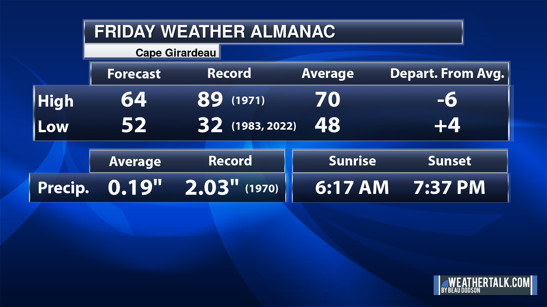
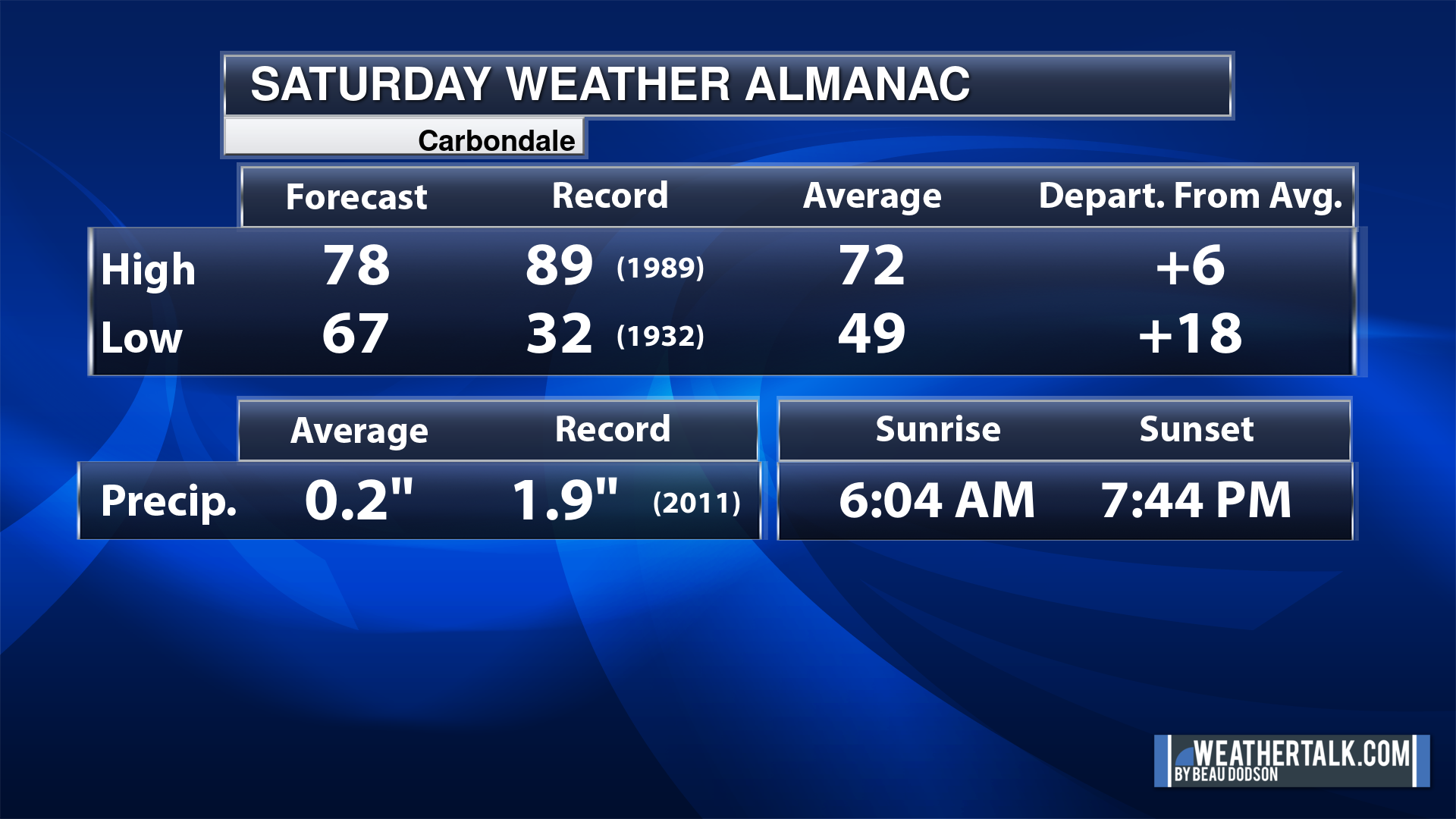
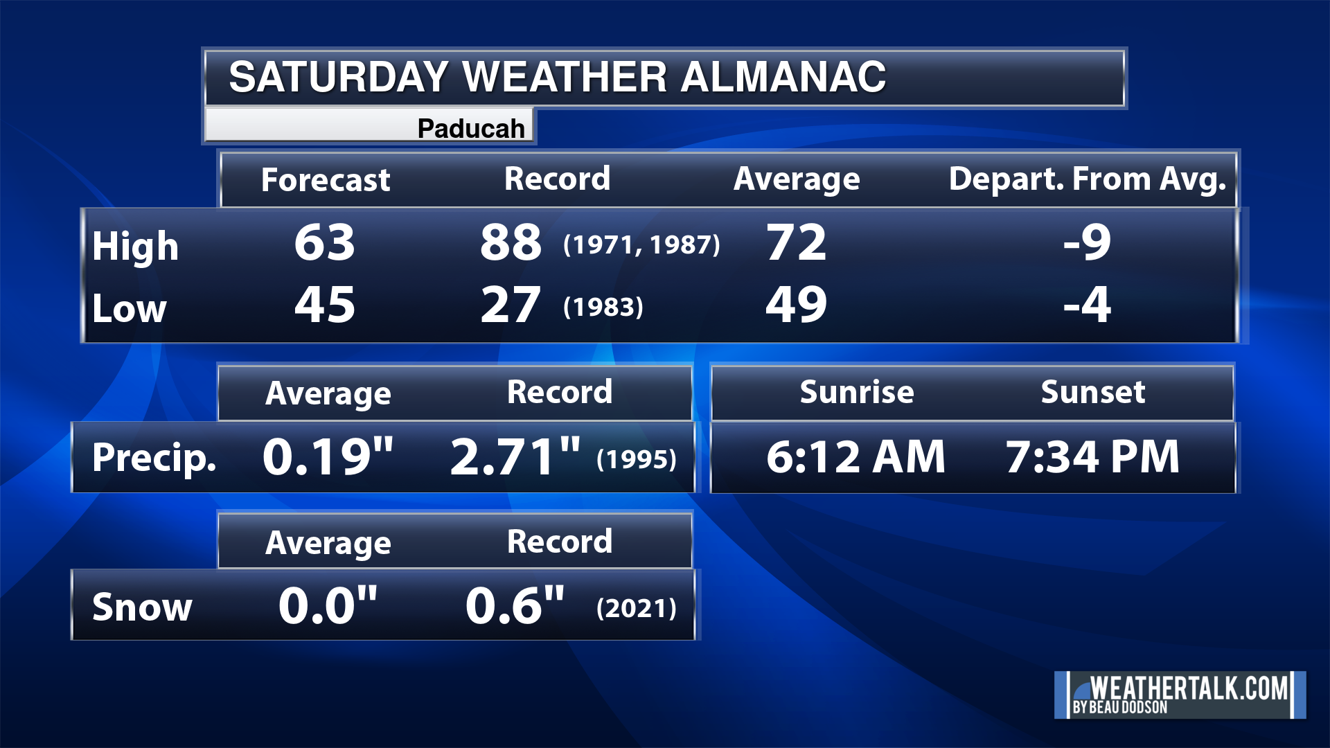
Today’s Local Almanacs (for a few select cities). Your location will be comparable.
Note, the low is this morning’s low and not tomorrows.
The forecast temperature shows you today’s expected high and this morning’s low.
The graphic shows you the record high and record low for today. It shows you what year that occurred, as well.
It then shows you what today’s average temperature is.
It shows you the departures (how may degrees above or below average temperatures will be ).
It shows you the average precipitation for today. Average comes from thirty years of rain totals.
It also shows you the record rainfall for the date and what year that occurred.
The sunrise and sunset are also shown.


![]()
.
.
Thursday Forecast: Mostly sunny. Warmer. More humid. Some clouds far north with a slight chance of thunderstorms. after 5 pm (mainly near the I-64 corridor).
What is the chance of precipitation?
Far northern southeast Missouri ~ 10%
Southeast Missouri ~ 0%
The Missouri Bootheel ~ 0%
I-64 Corridor of southern Illinois ~ 10%
Southern Illinois ~ 0%
Extreme southern Illinois (southern seven counties) ~ 0%
Far western Kentucky (Purchase area) ~ 0%
The Pennyrile area of western KY ~ 0%
Northwest Kentucky (near Indiana border) ~ 0%
Northwest Tennessee ~ 0%
Coverage of precipitation: Isolated if any at all (far north)
Timing of the precipitation: After 4 PM
Far northern southeast Missouri ~ 90° to 94°
Southeast Missouri ~ 90° to 94°
The Missouri Bootheel ~ 90° to 94°
I-64 Corridor of southern Illinois ~ 90° to 94°
Southern Illinois ~ 90° to 94°
Extreme southern Illinois (southern seven counties) ~ 90° to 94°
Far western Kentucky ~ 90° to 94°
The Pennyrile area of western KY ~ 90° to 94°
Northwest Kentucky (near Indiana border) ~ 90° to 94°
Northwest Tennessee ~ 90° to 94°
Winds will be from this direction: South at 5 mph.
Wind chill or heat index (feels like) temperature forecast: 90° to 94°
What impacts are anticipated from the weather?
Should I cancel my outdoor plans? No
UV Index: 10 – very high
Sunrise: 5:34 AM
Sunset: 8:17 PM
.
Thursday Night Forecast: Partly cloudy. Some clouds far north with a chance of a thunderstorm. an area of storms will approach from northeast MO and central IL. It will move south and dissipate. It may live long enough to bring some thunderstorms into our northern counties near the I-64 corridor.
What is the chance of precipitation?
Far northern southeast Missouri ~ 30%
Southeast Missouri ~ 20%
The Missouri Bootheel ~ 0%
I-64 Corridor of southern Illinois ~ 30%
Southern Illinois ~ 20%
Extreme southern Illinois (southern seven counties) ~ 10%
Far western Kentucky (Purchase area) ~ 0%
The Pennyrile area of western KY ~ 0%
Northwest Kentucky (near Indiana border) ~ 20%
Northwest Tennessee ~ 0%
Coverage of precipitation: Isolated (mainly far north)
Timing of the precipitation: Before 12 am
Temperature range:
Far northern southeast Missouri ~ 65° to 70°
Southeast Missouri ~ 65° to 70°
The Missouri Bootheel ~ 65° to 70°
I-64 Corridor of southern Illinois ~ 65° to 70°
Southern Illinois ~ 65° to 70°
Extreme southern Illinois (southern seven counties) ~ 65° to 70°
Far western Kentucky ~ 65° to 70°
The Pennyrile area of western KY ~ 65° to 70°
Northwest Kentucky (near Indiana border) ~ 65° to 70°
Northwest Tennessee ~ 65° to 70°
Winds will be from this direction: Southwest 2 to 5 mph.
Wind chill or heat index (feels like) temperature forecast: 65° to 70°
What impacts are anticipated from the weather? Wet roadways and lightning.
Should I cancel my outdoor plans? No
Moonrise: 12:24 PM
Moonset: 12:54 AM
The phase of the moon: First Quarter
.
Friday Forecast: Partly sunny. Hot. A slight chance of thunderstorms.
What is the chance of precipitation?
Far northern southeast Missouri ~ 20%
Southeast Missouri ~ 20%
The Missouri Bootheel ~ 20%
I-64 Corridor of southern Illinois ~ 20%
Southern Illinois ~ 20%
Extreme southern Illinois (southern seven counties) ~ 20%
Far western Kentucky (Purchase area) ~ 20%
The Pennyrile area of western KY ~ 20%
Northwest Kentucky (near Indiana border) ~ 20%
Northwest Tennessee ~ 20%
Coverage of precipitation: Widely scattered
Timing of the precipitation: Mainly during the afternoon
Far northern southeast Missouri ~ 90° to 94°
Southeast Missouri ~ 90° to 94°
The Missouri Bootheel ~ 90° to 94°
I-64 Corridor of southern Illinois ~ 90° to 94°
Southern Illinois ~ 90° to 94°
Extreme southern Illinois (southern seven counties) ~ 90° to 94°
Far western Kentucky ~ 90° to 94°
The Pennyrile area of western KY ~ 90° to 94°
Northwest Kentucky (near Indiana border) ~ 90° to 94°
Northwest Tennessee ~ 90° to 94°
Winds will be from this direction: West northwest at 6 to 12 mph.
Wind chill or heat index (feels like) temperature forecast: 92° to 95°
What impacts are anticipated from the weather? Wet roadways and lightning.
Should I cancel my outdoor plans? No
UV Index: 10 – very high
Sunrise: 5:34 AM
Sunset: 8:18 PM
.
Friday Night Forecast: Mostly clear. A slight chance of evening storms.
What is the chance of precipitation?
Far northern southeast Missouri ~ 10%
Southeast Missouri ~ 10%
The Missouri Bootheel ~ 10%
I-64 Corridor of southern Illinois ~ 10%
Southern Illinois ~ 10%
Extreme southern Illinois (southern seven counties) ~ 10%
Far western Kentucky (Purchase area) ~ 10%
The Pennyrile area of western KY ~ 10%
Northwest Kentucky (near Indiana border) ~ 10%
Northwest Tennessee ~ 10%
Coverage of precipitation: Isolated
Timing of the precipitation: Before 10 pm
Temperature range:
Far northern southeast Missouri ~ 65° to 70°
Southeast Missouri ~ 65° to 70°
The Missouri Bootheel ~ 65° to 70°
I-64 Corridor of southern Illinois ~ 65° to 70°
Southern Illinois ~ 65° to 70°
Extreme southern Illinois (southern seven counties) ~ 65° to 70°
Far western Kentucky ~ 65° to 70°
The Pennyrile area of western KY ~ 65° to 70°
Northwest Kentucky (near Indiana border) ~ 65° to 70°
Northwest Tennessee ~ 65° to 70°
Winds will be from this direction: Light wind.
Wind chill or heat index (feels like) temperature forecast: 65° to 70°
What impacts are anticipated from the weather? Isolated wet roadways and lightning.
Should I cancel my outdoor plans? No
Moonrise: 1:21 PM
Moonset: 1:15 AM
The phase of the moon: Waxing Gibbous
.
Saturday Forecast: Mostly sunny. Hot.
What is the chance of precipitation?
Far northern southeast Missouri ~ 0%
Southeast Missouri ~ 0%
The Missouri Bootheel ~ 0%
I-64 Corridor of southern Illinois ~ 0%
Southern Illinois ~ 0%
Extreme southern Illinois (southern seven counties) ~ 0%
Far western Kentucky (Purchase area) ~ 0%
The Pennyrile area of western KY ~ 0%
Northwest Kentucky (near Indiana border) ~ 0%
Northwest Tennessee ~ 0%
Coverage of precipitation:
Timing of the precipitation:
Far northern southeast Missouri ~ 90° to 94°
Southeast Missouri ~ 90° to 94°
The Missouri Bootheel ~ 90° to 94°
I-64 Corridor of southern Illinois ~ 90° to 94°
Southern Illinois ~ 90° to 94°
Extreme southern Illinois (southern seven counties) ~ 90° to 94°
Far western Kentucky ~ 90° to 94°
The Pennyrile area of western KY ~ 90° to 94°
Northwest Kentucky (near Indiana border) ~ 90° to 94°
Northwest Tennessee ~ 90° to 94°
Winds will be from this direction: Northeast 5 to 10 mph.
Wind chill or heat index (feels like) temperature forecast: 92° to 95°
What impacts are anticipated from the weather?
Should I cancel my outdoor plans? No
UV Index: 10 – very high
Sunrise: 5:34 AM
Sunset: 8:18 PM
.
Saturday Night Forecast: Mostly clear.
What is the chance of precipitation?
Far northern southeast Missouri ~ 0%
Southeast Missouri ~ 0%
The Missouri Bootheel ~ 0%
I-64 Corridor of southern Illinois ~ 0%
Southern Illinois ~ 0%
Extreme southern Illinois (southern seven counties) ~ 0%
Far western Kentucky (Purchase area) ~ 0%
The Pennyrile area of western KY ~ 0%
Northwest Kentucky (near Indiana border) ~ 0%
Northwest Tennessee ~ 0%
Coverage of precipitation:
Timing of the precipitation:
Temperature range:
Far northern southeast Missouri ~ 68° to 72°
Southeast Missouri ~ 68° to 72°
The Missouri Bootheel ~ 68° to 72°
I-64 Corridor of southern Illinois ~ 68° to 72°
Southern Illinois ~ 68° to 72°
Extreme southern Illinois (southern seven counties) ~ 68° to 72°
Far western Kentucky ~ 68° to 72°
The Pennyrile area of western KY ~ 68° to 72°
Northwest Kentucky (near Indiana border) ~ 68° to 72°
Northwest Tennessee ~ 68° to 72°
Winds will be from this direction: Light wind.
Wind chill or heat index (feels like) temperature forecast: 68° to 72°
What impacts are anticipated from the weather?
Should I cancel my outdoor plans? No
Moonrise: 2:18 PM
Moonset: 1:36 AM
The phase of the moon: Waxing Gibbous
.
Sunday Forecast: Mostly sunny. Hot. A slight chance of thunderstorms.
What is the chance of precipitation?
Far northern southeast Missouri ~ 20%
Southeast Missouri ~ 20%
The Missouri Bootheel ~ 20%
I-64 Corridor of southern Illinois ~ 20%
Southern Illinois ~ 20%
Extreme southern Illinois (southern seven counties) ~ 20%
Far western Kentucky (Purchase area) ~ 20%
The Pennyrile area of western KY ~ 20%
Northwest Kentucky (near Indiana border) ~ 20%
Northwest Tennessee ~ 20%
Coverage of precipitation: Isolated
Timing of the precipitation: After 12 pm
Far northern southeast Missouri ~ 94° to 98°
Southeast Missouri ~ 94° to 98°
The Missouri Bootheel ~ 94° to 98°
I-64 Corridor of southern Illinois ~ 94° to 98°
Southern Illinois ~ 94° to 98°
Extreme southern Illinois (southern seven counties) ~ 94° to 98°
Far western Kentucky ~ 94° to 98°
The Pennyrile area of western KY ~ 94° to 98°
Northwest Kentucky (near Indiana border) ~ 94° to 98°
Northwest Tennessee ~ 94° to 98°
Winds will be from this direction: South southeast 5 to 10 mph.
Wind chill or heat index (feels like) temperature forecast: 98° to 104°
What impacts are anticipated from the weather? Hot weather conditions. Use care, as always. Wet roadways. Lightning.
Should I cancel my outdoor plans? No
UV Index: 10 – very high
Sunrise: 5:34 AM
Sunset: 8:18 PM
.
Sunday Night Forecast: Mostly clear. A slight chance of an evening thunderstorm.
What is the chance of precipitation?
Far northern southeast Missouri ~ 10%
Southeast Missouri ~ 10%
The Missouri Bootheel ~ 10%
I-64 Corridor of southern Illinois ~ 10%
Southern Illinois ~ 10%
Extreme southern Illinois (southern seven counties) ~ 10%
Far western Kentucky (Purchase area) ~ 10%
The Pennyrile area of western KY ~ 10%
Northwest Kentucky (near Indiana border) ~ 10%
Northwest Tennessee ~ 10%
Coverage of precipitation: None to isolated
Timing of the precipitation: Before 12 am
Temperature range:
Far northern southeast Missouri ~ 70° to 75°
Southeast Missouri ~ 70° to 75°
The Missouri Bootheel ~ 70° to 75°
I-64 Corridor of southern Illinois ~ 70° to 75°
Southern Illinois ~ 70° to 75°
Extreme southern Illinois (southern seven counties) ~ 70° to 75°
Far western Kentucky ~ 70° to 75°
The Pennyrile area of western KY ~ 70° to 75°
Northwest Kentucky (near Indiana border) ~ 70° to 75°
Northwest Tennessee ~ 70° to 75°
Winds will be from this direction: Light wind.
Wind chill or heat index (feels like) temperature forecast: 70° to 75°
What impacts are anticipated from the weather? Wet roadways and lightning.
Should I cancel my outdoor plans? No
Moonrise: 3:16 PM
Moonset: 1:57 AM
The phase of the moon: Waxing Gibbous
.
Click here if you would like to return to the top of the page.

-
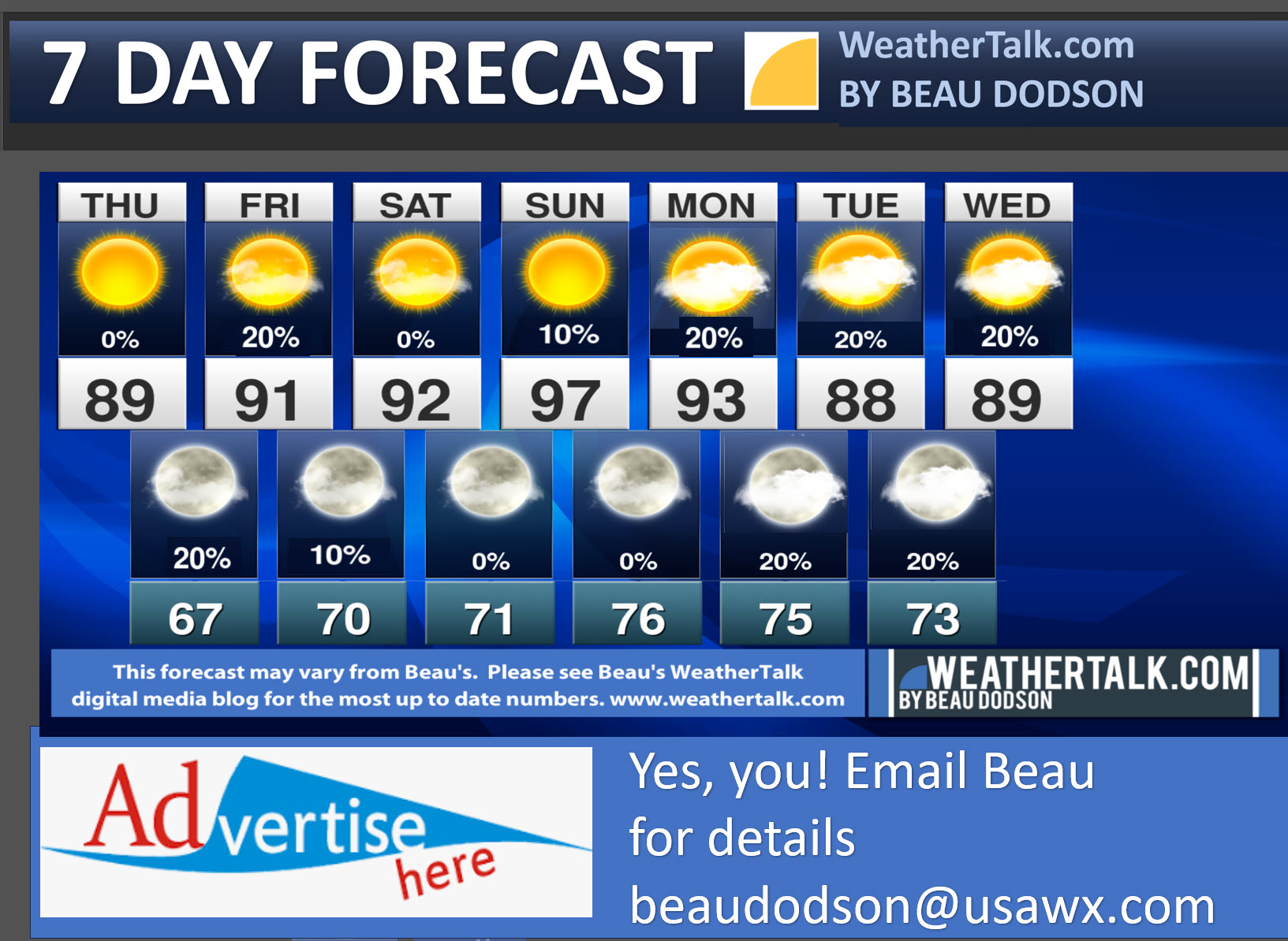
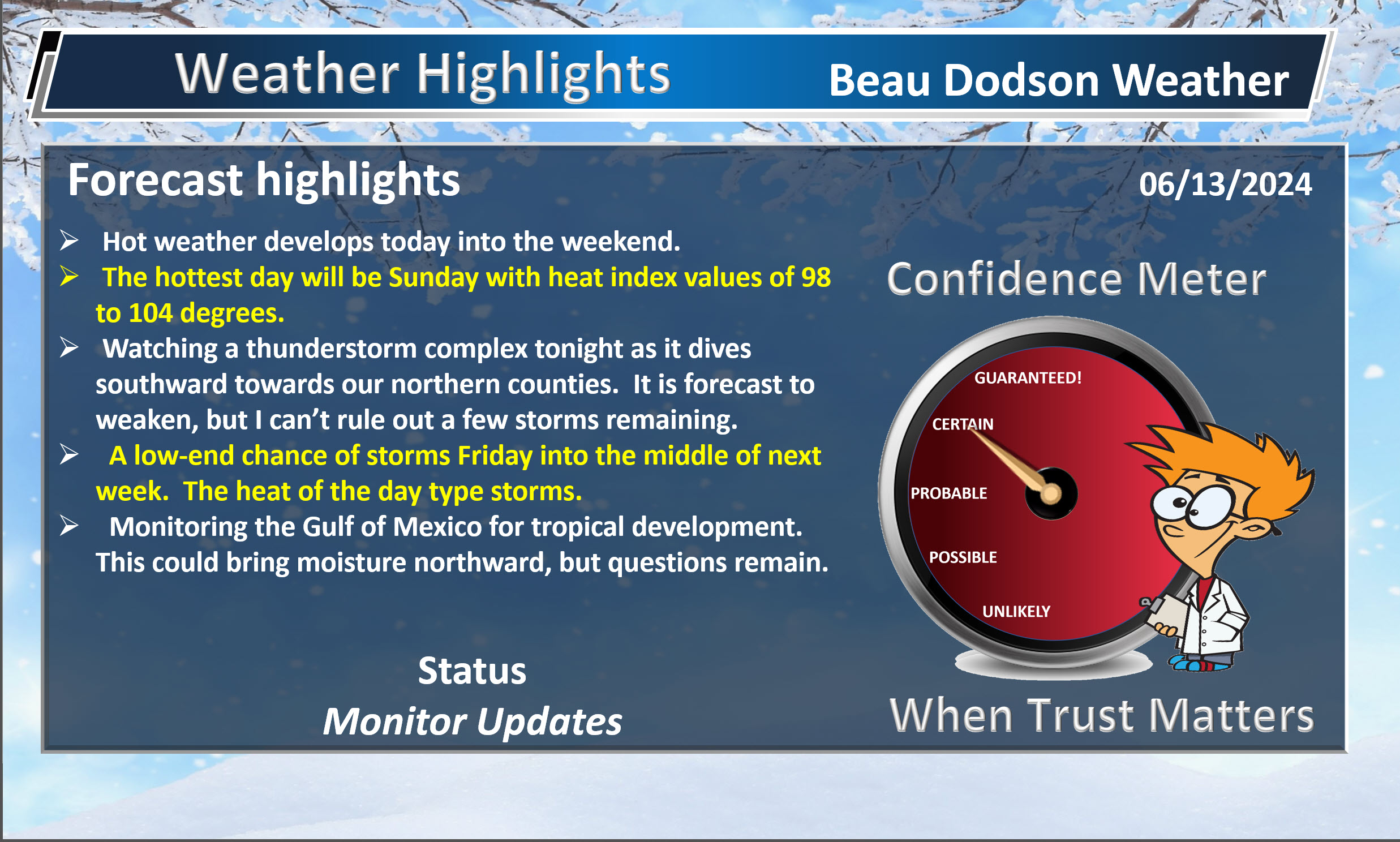
- Hot weather has arrived.
- The hottest day in the short-term will be Sunday with highs in the middle 90s and heat index values of 98 to 104 degrees. Use care, always.
- Watching thunderstorm chances tonight over our northern counties.
- Slight thunderstorm chances area-wide Friday into next week.
- Watching a cold front late next week with showers and storms. Cooler drier air behind the front. Medium confidence there will be a front. Low confidence in how far south it will dive.
Weather advice:
Do you have any suggestions or comments? Email me at beaudodson@usawx.com
Make sure you have three to five ways of receiving your severe weather information.
Weather Talk is one of those ways.
.
Beau’s Forecast Discussion
Good day, everyone.
We have experienced some nice weather over the past few days. Perfect spring weather. I hope you were able to enjoy it.
We are now going to enter a period of hot and muggy weather. Summer-like weather.
You can expect daily highs in the upper 80s to middle 90s into next week. Our only hope of some relief would be clouds and isolated thunderstorms. That would lower temps by a bit.
Of course, any rain would make it feel muggier. There is also a lot of moisture in the ground that still has to evaporate from recent heavy rains.
The moisture in the ground will make it feel muggier, as well. At the same time, that high level of moisture will help shave a few degrees off the thermometer. If we were in drought, then we would like be forecasting upper 90s to low 100s.
As it stands, we are facing a typical summer (late spring) heat wave with widespread upper 80s and 90s. Heat index values will mostly be in the 90s, but Sunday’s heat index values will likely jump into the 98 to 104 degree range. Muggy. Air you wear!
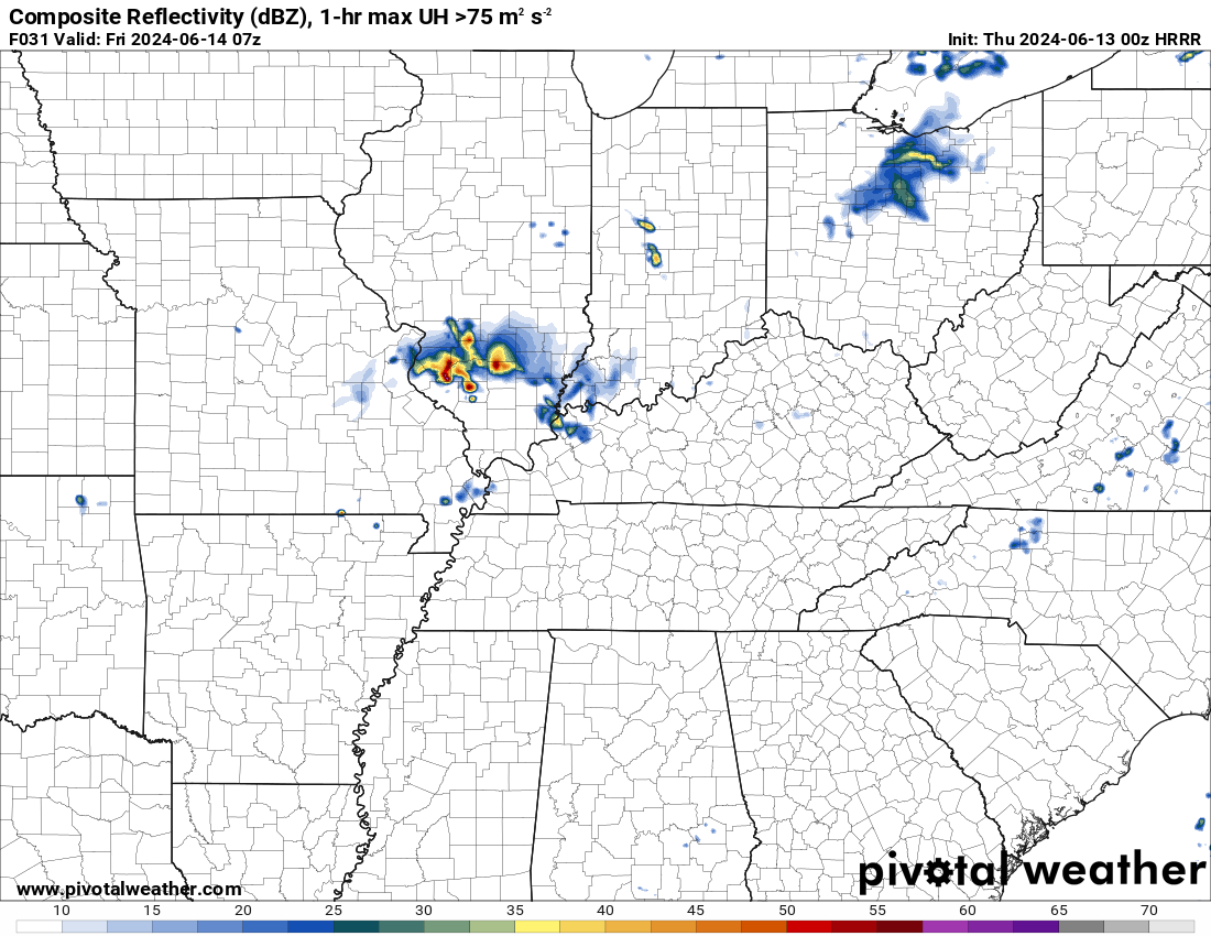
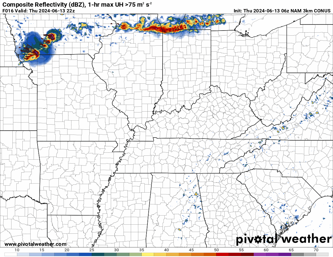
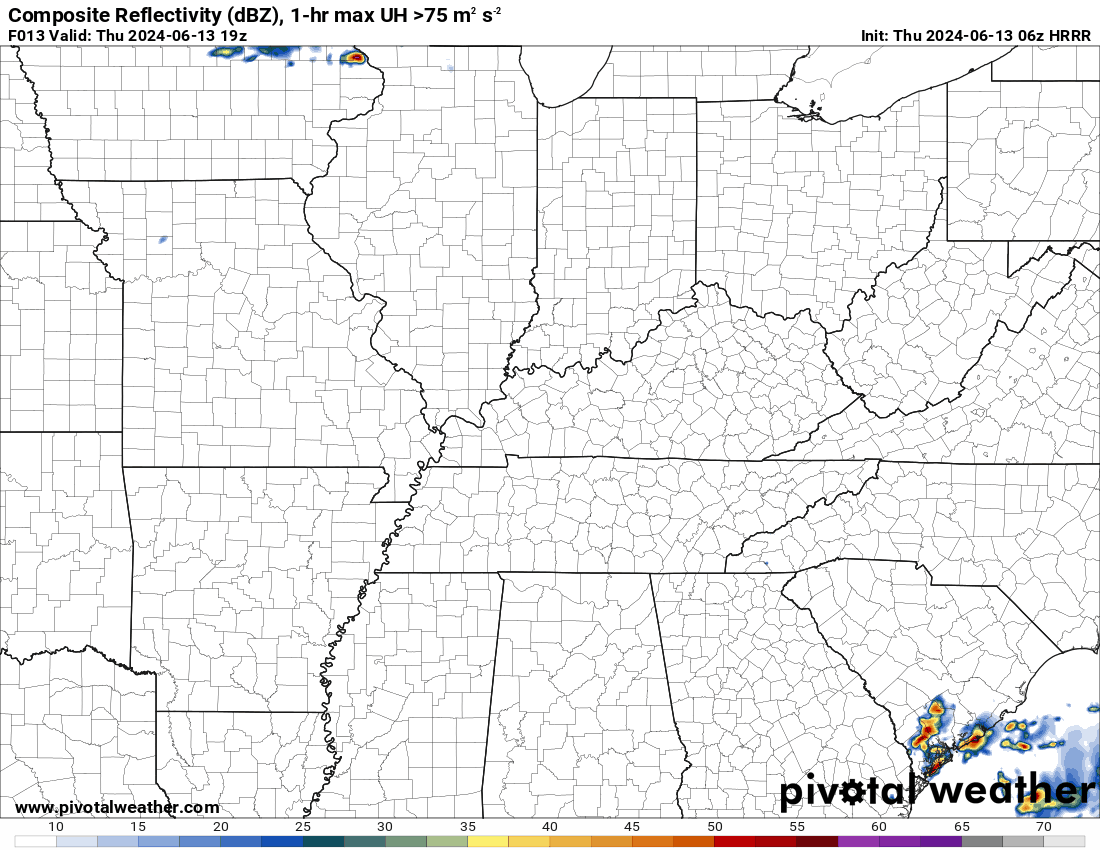
A cold front will nudge into the region tonight and tomorrow. This weak cold front will spark an outbreak of severe thunderstorms over northern Missouri and northern and central Illinois today and tonight.
That line of storms will rapidly dive southward towards our region tonight. With time, however, it will weaken and dissipate. It will run out of energy to work with.
You can see that idea on these three charts. This is tonight into tomorrow morning. Watch how the storms dissipate and weaken with time.
5 PM this evening.
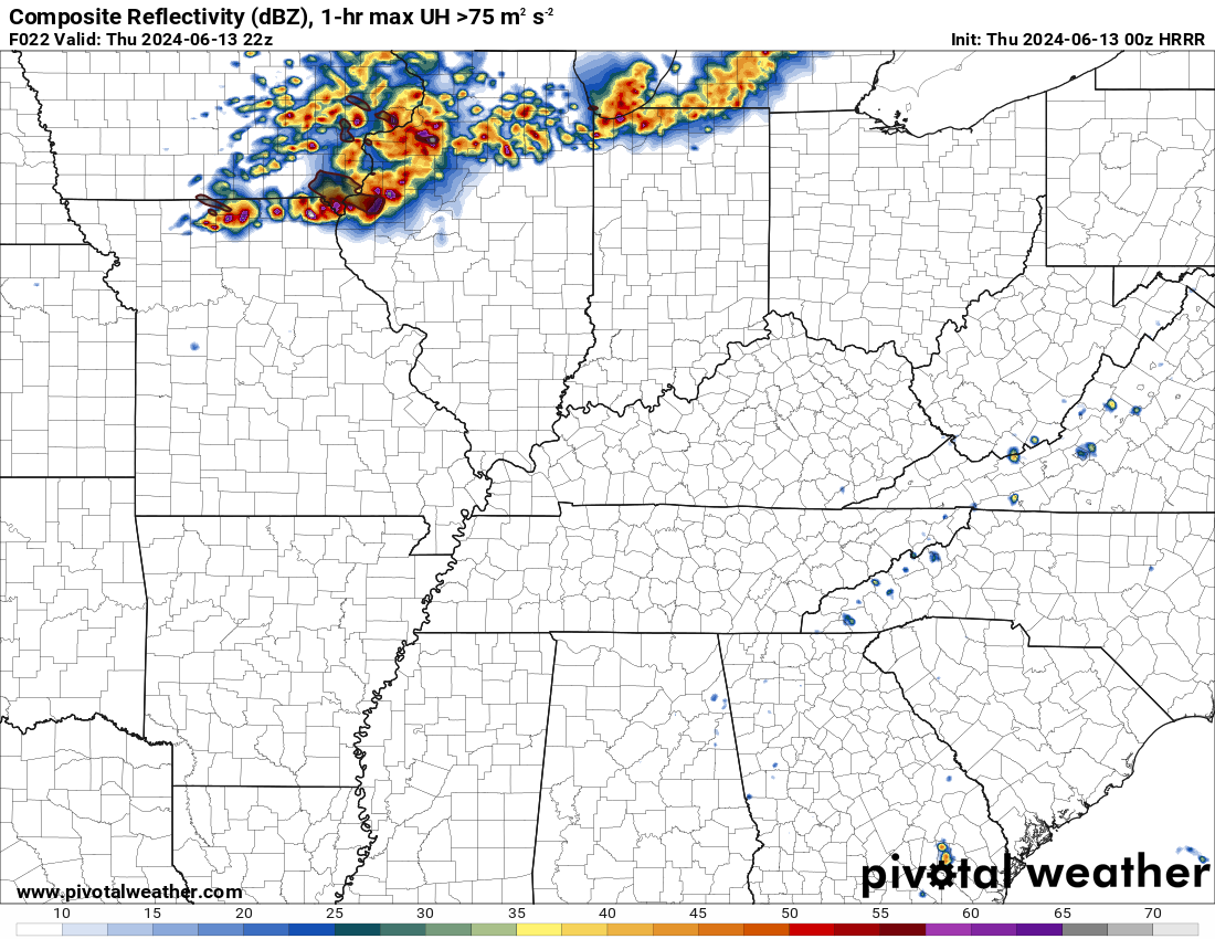
2 AM tonight
5 AM tomorrow
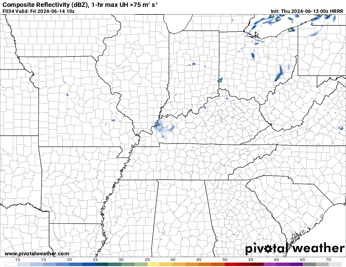
I do have a chance of thunderstorms over northern portions of southeast Missouri and northern portions of southern Illinois tonight. The storms may linger just long enough to clip my northern counties. But, again, the entire system will dissipate with time.
Friday will be hot and humid. An isolated thunderstorm may redevelop along the weak dying cold front.
I have low-end thunderstorm chances Sunday through Thursday of next week, as well. Typical summer like pop-up thunderstorms that can produce very heavy rain and gusty winds over small areas. I do not expect widespread showers and thunderstorms during this time period.
THe peak time for thunderstorm development will be during the afternoon and early evening hours. This is when instability will be at its highest.
Most areas will remain dry, hot, and muggy.
I am monitoring July. We are calling for a top ten hottest Julys on record for the United States as a whole. A bold prediction, but the forecast charts back this up.
The updated July forecast replects the potential for extreme heat over portons of the central United States. Numerous days with 90s and 100s. Especially in the red zone.
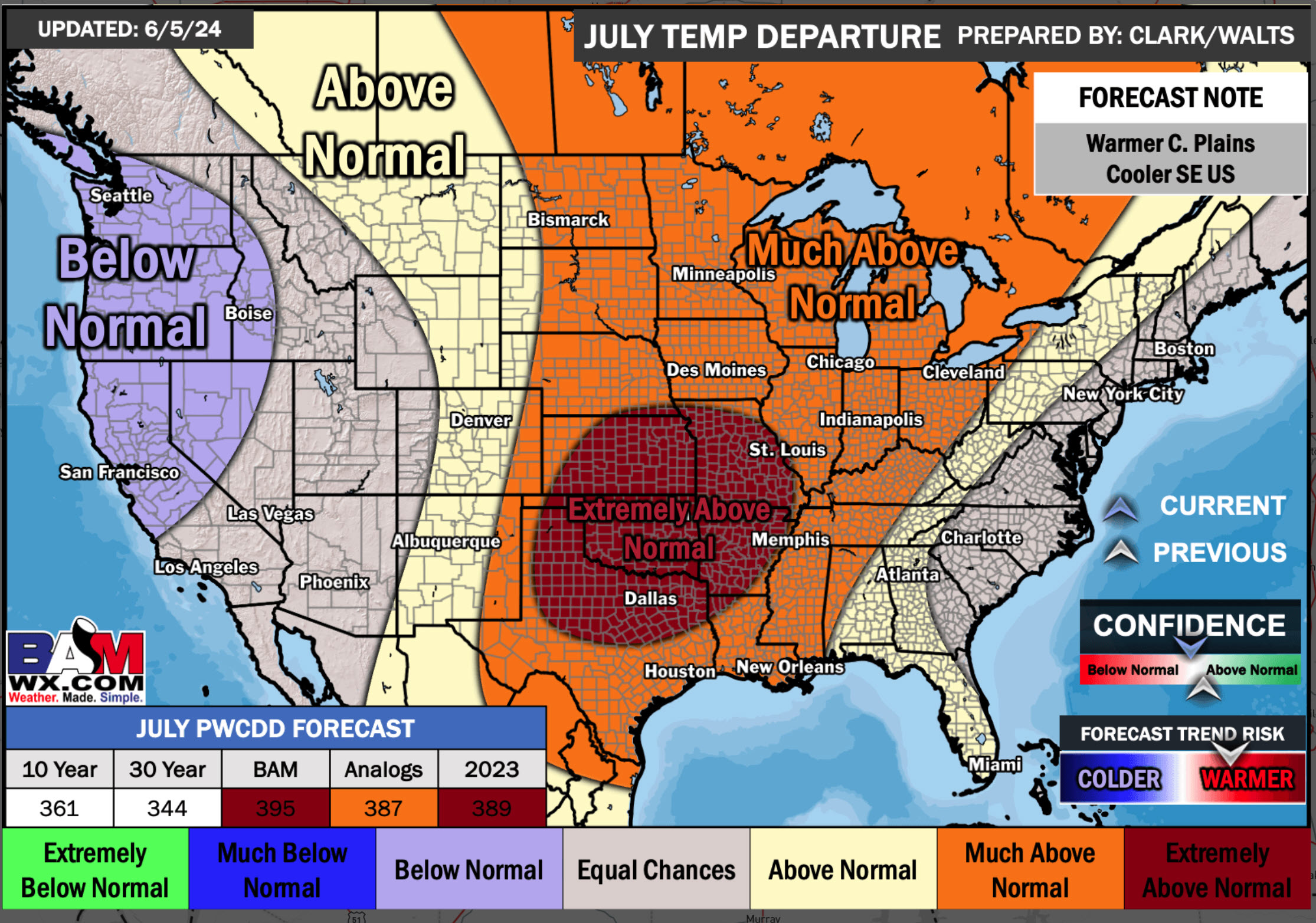
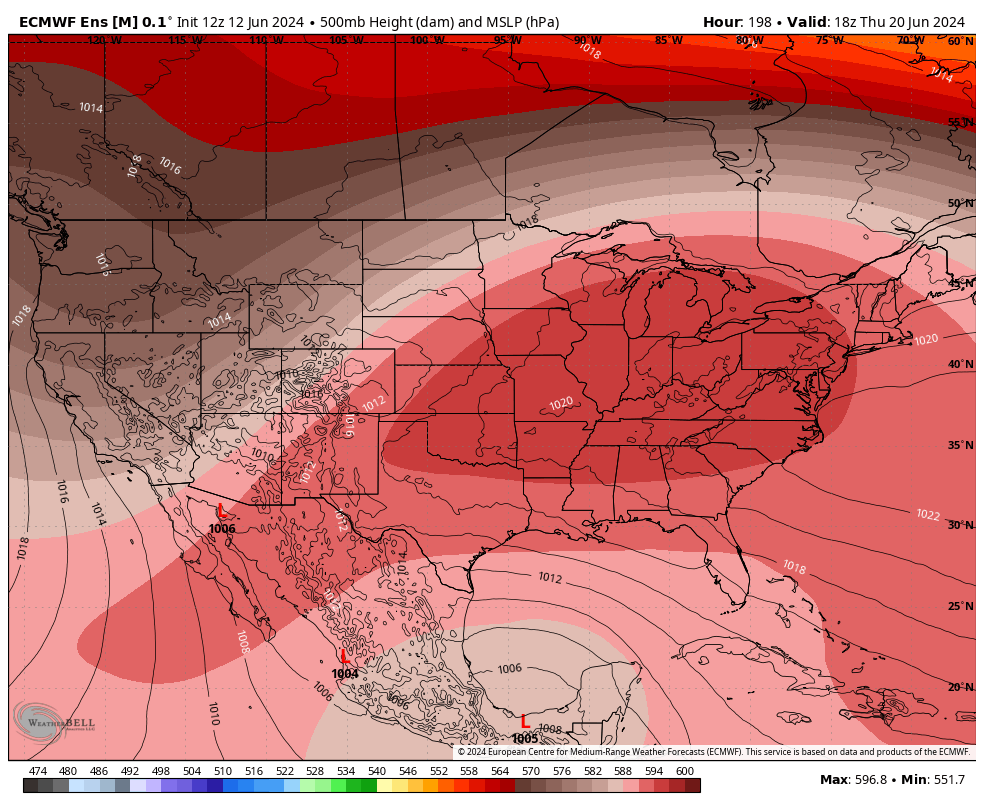
This heat will be because of a ridge of high pressure. Storm chasers call this the “death ridge” because it can shut down thunderstorm chances.
Models are showing a high chance of a heat wave next week in the region. The orange colors represent the heat ridge of high pressure. Probabilities of this are high.
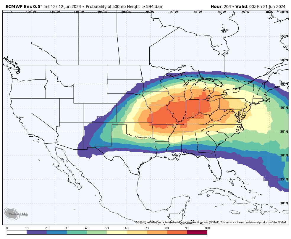
Another graphic showing the high pressure ridge over the central and eastern half of the United States.
If the ridge nudges southwest, over time, then we will return to a stormy pattern.
Thunderstorm often develop along the edge of the high pressure. These clusters of storms can be severe and are called MCS’s. They can produce Derecho’s, as well. Derecho’s can produce very high wind and hail over large areas.
We call this the ring of fire.
Thunderstorms often follow the 588 line on the 500 mb charts. That could happen late next week as the ridge moves southwest.
I will be watching for a cold front and thunderstorms around June 22nd to 24th. This GEFS model map for the 23rd shows the 588 line over our region and the center of the ridge down in Arizona and New Mexico. This could lead to higher chances of thunderstorms.
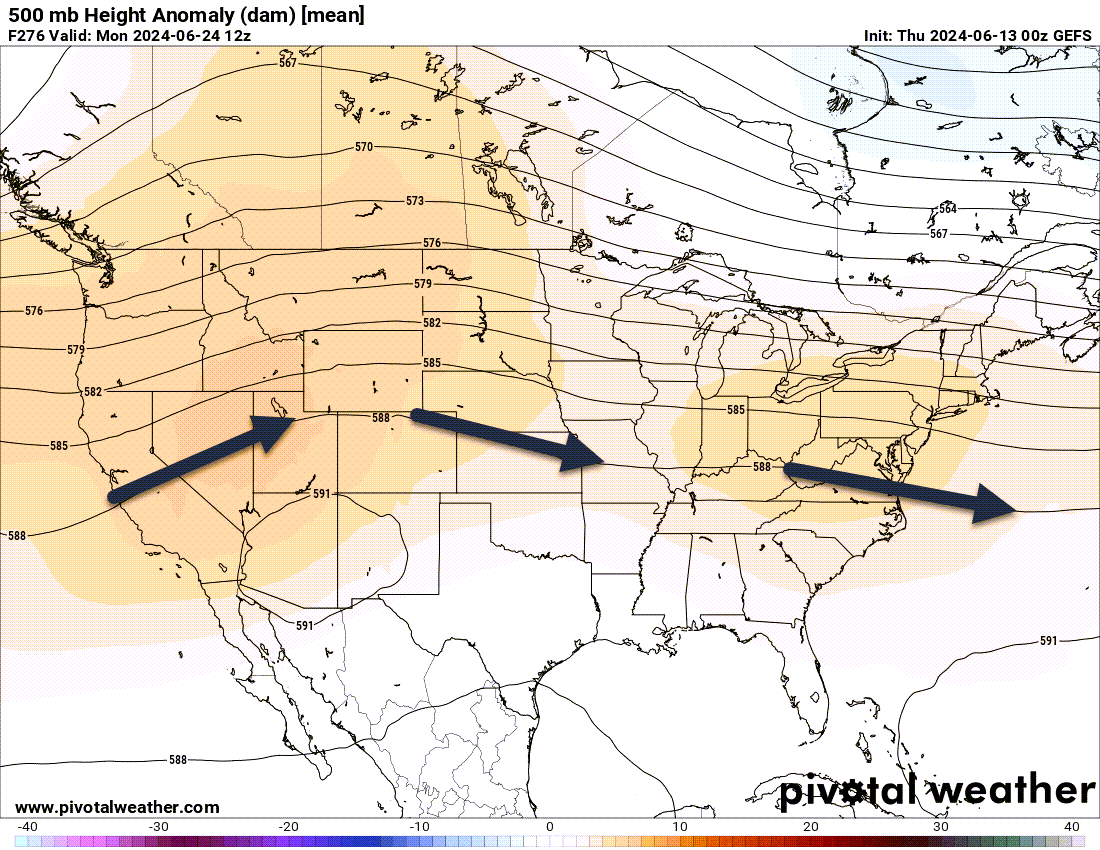
We will have to see if the high pressure stays parked over our region or if it nudges southeast and southwest of us. Typically, they move around.
That will likely be the deciding factor in our summer forecast. Where the high pressure ridge develops and parks itself.
Our summer forecast has been for a hot one. Analogs include 1988 and 2012.
The wild card in the summer forecast will be the tropics. Any tropical development could bring beneficial rains to our region. Dying Gulf of Mexico tropical storms and hurricanes are no stranger to our region.
We are forecasting a hyper-active hurricane season with numerous named systems.
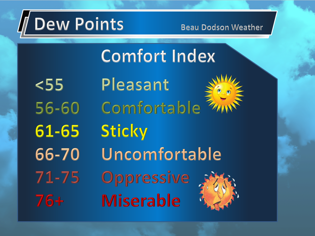
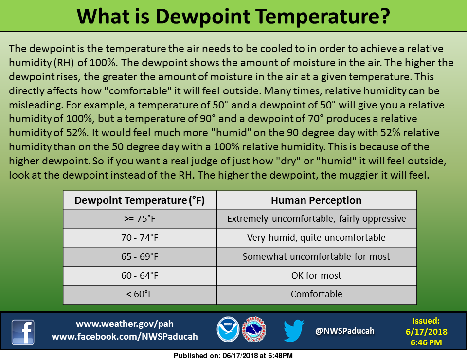
It will become increasinly muggy over the coming days. This is because of dew points.
Today’s dew points
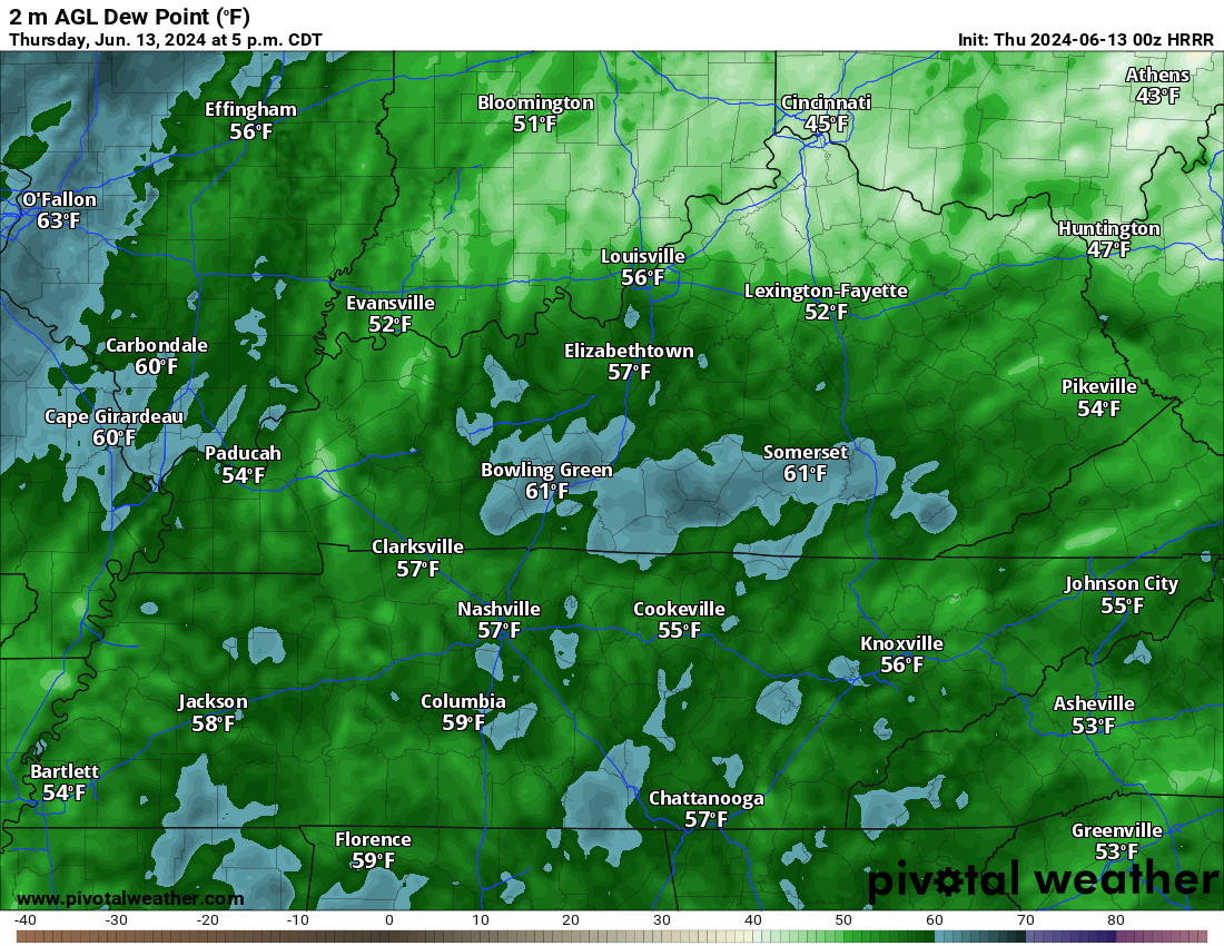
Sunday dew points (see the difference)
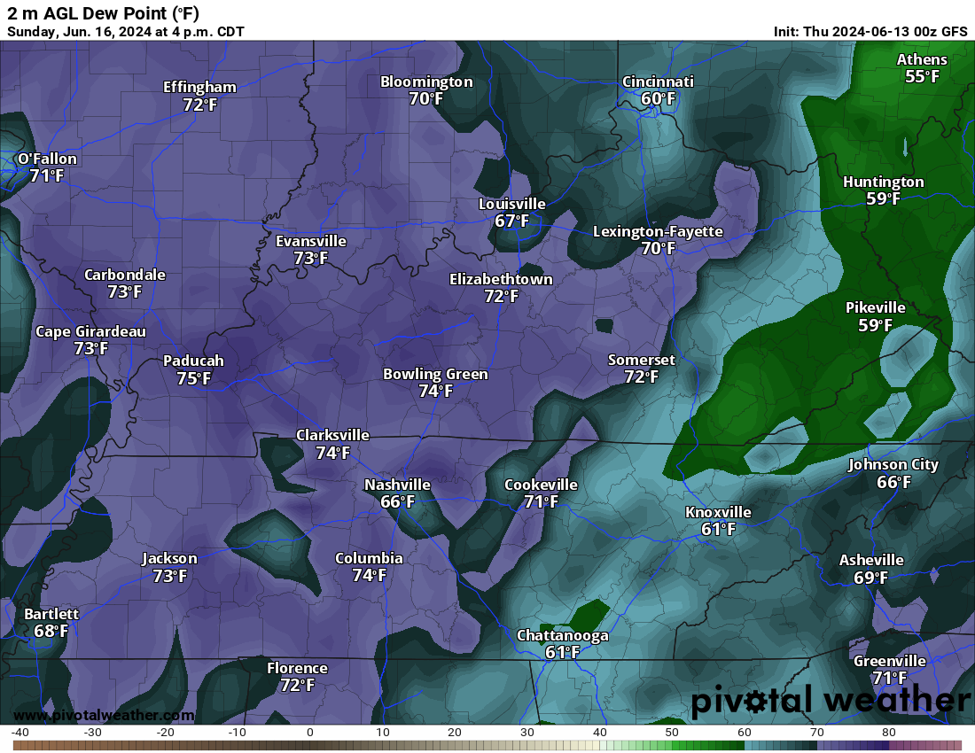
Air you wear!
You will hear me mention dew points frequently during the summer months and during severe weather.
What are dew points? Dew points are what make it feel muggy outside. They will slowly be on the rise as we move through the work-week.
A lot of people talk about humidity, but it is the dew point that makes the difference in how it feels outside.
These conditions won’t initially trigger a heat advisory or any National Weather Service products, but it is a good time to start thinking about heat safety.
Heat Safety


![]()
.
Click here if you would like to return to the top of the page.
This outlook covers southeast Missouri, southern Illinois, western Kentucky, and far northwest Tennessee.

.
Today’s Storm Prediction Center’s (SPC) Severe Weather Outlook
Light green is where thunderstorms may occur but should be below severe levels.
Dark green is a level one risk. Yellow is a level two risk. Orange is a level three (enhanced) risk. Red is a level four (moderate) risk. Pink is a level five (high) risk.
One is the lowest risk. Five is the highest risk.
A severe storm is one that produces 58 mph wind or higher, quarter or larger size hail, and/or a tornado.
Explanation of tables. Click here.
Day One Severe Weather Outlook

Day One Severe Weather Outlook. Zoomed in on our region.

.
Day One Tornado Probability Outlook

Day One Regional Tornado Outlook. Zoomed in on our region.

.
Day One Large Hail Probability Outlook

Day One Regional Hail Outlook. Zoomed in on our region.

.
Day One High wind Probability Outlook

Day One Regional Wind Outlook. Zoomed in on our region.

.
Tomorrow’s severe weather outlook. Day two outlook.

Day Two Outlook. Zoomed in on our region.

.
Day Three Severe Weather Outlook

.

.
The images below are from NOAA’s Weather Prediction Center.
24-hour precipitation outlook..
 .
.
.
48-hour precipitation outlook.
. .
.
![]()
_______________________________________
.

Click here if you would like to return to the top of the page.
Again, as a reminder, these are models. They are never 100% accurate. Take the general idea from them.
What should I take from these?
- The general idea and not specifics. Models usually do well with the generalities.
- The time-stamp is located in the upper left corner.
.
What am I looking at?
You are looking at computer model data. Meteorologists use many different models to forecast the weather.
Occasionally, these maps are in Zulu time. 12z=7 AM. 18z=1 PM. 00z=7 PM. 06z=1 AM
Green represents light rain. Dark green represents moderate rain. Yellow and orange represent heavier rain.
.
This animation is the NAM Model.
This graphic shows you what this particular model believes the radar may look like. Each model may be a little different. The more models that agree, the higher the confidence in the forecast outcome.
Occasionally, these maps are in Zulu time. 12z=7 AM. 18z=1 PM. 00z=7 PM. 06z=1 AM
Double click images to enlarge them.
.
This animation is the FV3 Model.
This graphic shows you what this particular model believes the radar may look like. Each model may be a little different. The more models that agree, the higher the confidence in the forecast outcome.
Green is rain. Yellow and orange are heavier rain. Pink is a wintry mix. Blue is snow. Dark blue is heavier snow.
Occasionally, these maps are in Zulu time. 12z=7 AM. 18z=1 PM. 00z=7 PM. 06z=1 AM
Double click images to enlarge them.
.
This animation is the HRRR Model.
This graphic shows you what this particular model believes the radar may look like. Each model may be a little different. The more models that agree, the higher the confidence in the forecast outcome.
Green is rain. Yellow and orange are heavier rain. Pink is a wintry mix. Blue is snow. Dark blue is heavier snow.
Occasionally, these maps are in Zulu time. 12z=7 AM. 18z=1 PM. 00z=7 PM. 06z=1 AM
Double click images to enlarge them.
.
This animation is the GFS Model.
This graphic shows you what this particular model believes the radar may look like. Each model may be a little different. The more models that agree, the higher the confidence in the forecast outcome.
Green is rain. Yellow and orange are heavier rain. Pink is a wintry mix. Blue is snow. Dark blue is heavier snow.
Occasionally, these maps are in Zulu time. 12z=7 AM. 18z=1 PM. 00z=7 PM. 06z=1 AM
Double click images to enlarge them.
.
This animation is the EC Model.
This graphic shows you what this particular model believes the radar may look like. Each model may be a little different. The more models that agree, the higher the confidence in the forecast outcome.
Green is rain. Yellow and orange are heavier rain. Pink is a wintry mix. Blue is snow. Dark blue is heavier snow.
Occasionally, these maps are in Zulu time. 12z=7 AM. 18z=1 PM. 00z=7 PM. 06z=1 AM
Double click images to enlarge them.
.
..![]()

.
Click here if you would like to return to the top of the page.
.Average high temperatures for this time of the year are around 75 degrees.
Average low temperatures for this time of the year are around 54 degrees.
Average precipitation during this time period ranges from 0.80″ to 1.60″
Six to Ten Day Outlook.
Blue is below average. Red is above average. The no color zone represents equal chances.
Average highs for this time of the year are in the lower 60s. Average lows for this time of the year are in the lower 40s.

Green is above average precipitation. Yellow and brown favors below average precipitation. Average precipitation for this time of the year is around one inch per week.

.

Average low temperatures for this time of the year are around 54 degrees.
Average precipitation during this time period ranges from 0.80″ to 1.60″
.
Eight to Fourteen Day Outlook.
Blue is below average. Red is above average. The no color zone represents equal chances.

Green is above average precipitation. Yellow and brown favors below average precipitation. Average precipitation for this time of the year is around one inch per week.

.
![]()
The app is for subscribers. Subscribe at www.weathertalk.com/welcome then go to your app store and search for WeatherTalk
Subscribers, PLEASE USE THE APP. ATT and Verizon are not reliable during severe weather. They are delaying text messages.
The app is under WeatherTalk in the app store.

Apple users click here

Android users click here
.

Radars and Lightning Data
Interactive-city-view radars. Clickable watches and warnings.
https://wtalk.co/B3XHASFZ
If the radar is not updating then try another one. If a radar does not appear to be refreshing then hit Ctrl F5. You may also try restarting your browser.
Backup radar site in case the above one is not working.
https://weathertalk.com/morani
Regional Radar
https://imagery.weathertalk.com/prx/RadarLoop.mp4
** NEW ** Zoom radar with chaser tracking abilities!
ZoomRadar
Lightning Data (zoom in and out of your local area)
https://wtalk.co/WJ3SN5UZ
Not working? Email me at beaudodson@usawx.com
National map of weather watches and warnings. Click here.
Storm Prediction Center. Click here.
Weather Prediction Center. Click here.
.

Live lightning data: Click here.
Real time lightning data (another one) https://map.blitzortung.org/#5.02/37.95/-86.99
Our new Zoom radar with storm chases
.
.

Interactive GOES R satellite. Track clouds. Click here.
GOES 16 slider tool. Click here.
College of DuPage satellites. Click here
.

Here are the latest local river stage forecast numbers Click Here.
Here are the latest lake stage forecast numbers for Kentucky Lake and Lake Barkley Click Here.
.
.
Find Beau on Facebook! Click the banner.


 .
.